

Page 1

GETTING STARTED GUIDE
GeoExplorer® 2005 series
Page 2

Page 3

GETTING STARTED GUIDE
GeoExplorer® 2005 series
Version 1.00
Revision A
Part Number 46506-40-ENG
October 2005
Page 4

Contact Information
Trimble Navigation Limited, Mapping & GIS Business Area,
7401 Church Ranch Blvd, Westminster, 80021.
www.trimble.com.
Copyright and Trademarks
© 2002–2005, Trimble Navigation Limited. All rights
reserved.
Trimble, the Globe & Triangle logo, GeoExplorer, and GPS
Pathfinder are trademarks of Trimble Navigation Limited,
registered in the United States Patent and Trademark Office
and other countries. BoB, EVEREST, GeoBeacon, GeoXH,
GeoXM, GeoXT, GPS Analyst, GPScorrect, H-Star,
TerraSync, VRS, and Zephyr are trademarks of Trimble
Navigation Limited. Microsoft, Windows, Windows Mobile
and ActiveSync are either registered trademarks or
trademarks of Microsoft Corporation in the United States
and/or other countries. The Bluetooth word mark and logos
are owned by the Bluetooth SIG, Inc. and any use of such
marks by Trimble Navigation Limited is under license. All
other trademarks are the property of their respective
owners.
This product is covered by the following US patents:
5,187,450; 5,311,149; 5,402,450; 5,493,588; 5,815,539; 6,377,891;
6,587,788; and 6,807,485.
Release Notice
This is the October 2005 release (Revision A) of the
GeoExplorer 2005 Series Getting Started Guide, part number
46506-40-ENG. It applies to version 5.10 of the GeoExplorer
series operating system and firmware. The GeoExplorer
series handheld’s operating system is based on the
Microsoft Windows Mobile Version 5.0 software for Pocket
PC (5.1.1702).
Legal Notices
Limited Warranty Terms and Conditions
Product Limited Warranty
Subject to the terms and conditions set forth herein,
Trimble Navigation Limited (“Trimble”) warrants that for a
period of (1) year from date of purchase this Trimble
product (the “Product”) will substantially conform to
Trimble's publicly available specifications for the Product
and that the hardware and any storage media components
of the Product will be substantially free from defects in
materials and workmanship.
Product Software
Product software, whether built into hardware circuitry as
firmware, provided as a standalone computer software
product, embedded in flash memory, or stored on magnetic
or other media, is licensed and not sold. If accompanied by a
separate end user license agreement, use of any such
software will be subject to the terms of such end user license
agreement (including any differing limited warranty terms,
exclusions and limitations), which shall control over the
terms and conditions set forth in this limited warranty).
Software Updates
During the limited warranty period you will be entitled to
receive such Fix Updates and Minor Updates to the Product
software that Trimble releases and makes commercially
available and for which it does not charge separately, subject
to the procedures for delivery to purchasers of Trimble
products generally. If you have purchased the Product from
an authorized Trimble distributor rather than from Trimble
directly, Trimble may, at its option, forward the software Fix
Update or Minor Update to the Trimble distributor for final
distribution to you. Major Upgrades, new products, or
substantially new software releases, as identified by Trimble
are expressly excluded from this update process and limited
warranty. Receipt of software updates shall not serve to
extend the limited warranty period.
For purposes of this warranty the following definitions shall
apply: (1) “Fix Update” means an error correction or other
update created to fix a previous software version that does
not substantially conform to its published specifications; (2)
“Minor Update” occurs when enhancements are made to
current features in a software program; and (3) “Major
Upgrade” occurs when significant new features are added to
software, or when a new product containing new features
replaces the further development of a current product line.
Trimble reserves the right to determine, in its sole
discretion, what constitutes a significant new feature and
Major Upgrade.
Warranty Remedies
If the Trimble Product fails during the warranty period for
reasons covered by this Limited Warranty and you notify
Trimble of such failure during the warranty period, Trimble
at its option will repair OR replace the nonconforming
Product, OR refund the purchase price paid by you for the
Product, upon your return of the Product to Trimble in
accordance with Trimble's standard return material
authorization procedures.
How to Obtain Warranty Service
To obtain warranty service for the Product, please contact
your Trimble dealer. Alternatively, you may contact Trimble
to request warranty service at +1-408-481-6940 (24 hours a
day) or e-mail your request to
trimble_support@trimble.com. Please be prepared to
provide:
– your name, address, and telephone numbers
– proof of purchase
– this Trimble warranty card
– a description of the nonconforming Product including
the model number
– an explanation of the problem.
The customer service representative may need additional
information from you depending on the nature of the
problem.
Warranty Exclusions and Disclaimer
This Product limited warranty shall only apply in the event
and to the extent that (i) the Product is properly and
correctly installed, configured, interfaced, maintained,
stored, and operated in accordance with Trimble's
applicable operator's manual and specifications, and; (ii) the
Product is not modified or misused. This Product limited
warranty shall not apply to, and Trimble shall not be
responsible for defects or performance problems resulting
from (i) the combination or utilization of the Product with
hardware or software products, information, data, systems,
interfaces or devices not made, supplied or specified by
Tri mbl e; (ii) the operation of the Product under any
tion other than, or in addition to, Trimble's
specifica
standard specifications for its products; (iii) the
unauthorized, installation, modification, or use of the
Product; (iv) damage caused by: accident, lightning or other
electrical discharge, fresh or salt water immersion or spray;
or exposure to environmental conditions for which the
Product is not intended; or (v) normal wear and tear on
consumable parts (e.g., batteries). Trimble does not warrant
or guarantee the results obtained through the use of the
Product. NOTICE REGARDING PRODUCTS EQUIPPED
WITH GPS TECHNOLOGY: TRIMBLE IS NOT
Page 5

RESPONSIBLE FOR THE OPERATION OR FAILURE OF
OPERATION OF GPS SATELLITES OR THE AVAILABILITY
OF GPS SATELLITE SIGNALS.
THE FOREGOING LIMITED WARRANTY TERMS STATE
TRIMBLE'S ENTIRE LIABILITY, AND YOUR EXCLUSIVE
REMEDIES, RELATING TO PERFORMANCE OF THE
TRIMBLE PRODUCT. EXCEPT AS OTHERWISE
EXPRESSLY PROVIDED HEREIN, THE PRODUCT AND
ACCOMPANYING DOCUMENTATION AND MATERIALS
ARE PROVIDED “AS-IS” AND WITHOUT EXPRESS OR
IMPLIED WARRANTY OF ANY KIND, BY EITHER
TRIMBLE OR ANYONE WHO HAS BEEN INVOLVED IN ITS
CREATION, PRODUCTION, INSTALLATION, OR
DISTRIBUTION, INCLUDING, BUT NOT LIMITED TO, THE
IMPLIED WARRANTIES OF MERCHANTABILITY AND
FITNESS FOR A PARTICULAR PURPOSE, TITLE, AND
NONINFRINGEMENT. THE STATED EXPRESS
WARRANTIES ARE IN LIEU OF ALL OBLIGATIONS OR
LIABILITIES ON THE PART OF TRIMBLE ARISING OUT
OF, OR IN CONNECTION WITH, ANY PRODUCT.
SOME STATES AND JURISDICTIONS DO NOT ALLOW
LIMITATIONS ON DURATION OR THE EXCLUSION OF
AN IMPLIED WARRANTY, SO THE ABOVE LIMITATION
MAY NOT APPLY TO YOU.
Limitation of Liability
TRIMBLE'S ENTIRE LIABILITY UNDER ANY PROVISION
HEREIN SHALL BE LIMITED TO THE AMOUNT PAID BY
YOU FOR THE PRODUCT. TO THE MAXIMUM EXTENT
PERMITTED BY APPLICABLE LAW, IN NO EVENT SHALL
TRIMBLE OR ITS SUPPLIERS BE LIABLE FOR ANY
INDIRECT, SPECIAL, INCIDENTAL OR CONSEQUENTIAL
DAMAGE WHATSOEVER UNDER ANY CIRCUMSTANCE
OR LEGAL THEORY RELATING IN ANYWAY TO THE
PRODUCTS, SOFTWARE AND ACCOMPANYING
DOCUMENTATION AND MATERIALS, (INCLUDING,
WITHOUT LIMITATION, DAMAGES FOR LOSS OF
BUSINESS PROFITS, BUSINESS INTERRUPTION, LOSS OF
DATA, OR ANY OTHER PECUNIARY LOSS), REGARDLESS
OF WHETHER TRIMBLE HAS BEEN ADVISED OF THE
POSSIBILITY OF ANY SUCH LOSS AND REGARDLESS OF
THE COURSE OF DEALING WHICH DEVELOPS OR HAS
DEVELOPED BETWEEN YOU AND TRIMBLE. BECAUSE
SOME STATES AND JURISDICTIONS DO NOT ALLOW
THE EXCLUSION OR LIMITATION OF LIABILITY FOR
CONSEQUENTIAL OR INCIDENTAL DAMAGES, THE
ABOVE LIMITATION MAY NOT APPLY TO YOU.
PLEASE NOTE: THE ABOVE TRIMBLE LIMITED
WARRANTY PROVISIONS WILL NOT APPLY TO
PRODUCTS PURCHASED IN THOSE JURISDICTIONS,
SUCH AS COUNTRIES OF THE EUROPEAN ECONOMIC
COMMUNITY, IN WHICH PRODUCT WARRANTIES ARE
OBTAINED FROM THE LOCAL DISTRIBUTOR. IN SUCH
CASE, PLEASE CONTACT YOUR TRIMBLE DEALER
FOR APPLICABLE WARRANTY INFORMATION.
Registration
To receive information regarding updates and new
products, please contact your local dealer or visit the
Trimble website at www.trimble.com/register. Upon
registration you may select the newsletter, upgrade or new
product information you desire.
Notices
Class B Statement – Notice to Users. This equipment has
been tested and found to comply with the limits for a Class
B digital device, pursuant to Part 15 of the FCC rules. These
limits are designed to provide reasonable protection against
harmful interference in a residential installation. This
equipment generates, uses, and can radiate radio frequency
energy and, if not installed and used in accordance with the
instructions, may cause harmful interference to radio
communication. However, there is no guarantee that
interference will not occur in a particular installation. If this
equipment does cause harmful interference to radio or
television reception, which can be determined by turning
the equipment off and on, the user is encouraged to try to
correct the interference by one or more of the following
measures:
– Reorient or relocate the receiving antenna.
– Increase the separation between the equipment and the
receiver.
– Connect the equipment into an outlet on a circuit
different from that to which the receiver is connected.
– Consult the dealer or an experienced radio/TV
technician for help.
Changes and modifications not expressly approved by the
manufacturer or registrant of this equipment can void your
authority to operate this equipment under Federal
Communications Commission rules.
This device contains Bluetooth and wireless LAN radios and
has been evaluated under FCC Bulletin OET 65C and found
compliant with the requirements as set forth in CFR 47
Section 2.1093 addressing RF Exposure from radio
frequency devices. The radiated output power of this device
is far below the FCC radio frequency exposure limits.
The maximum SAR values measured from the device is:
802.11b wireless LAN: 0.043mW/g.
The external antenna connector provided in this device is
for GPS antennas only.
Accessories
The following accessories have been approved for use with
this device: P/N 53500-00 (support module) and
P/N 53550-00 (serial clip).
Canada
This digital apparatus does not exceed the Class B limits for
radio noise emissions from digital apparatus as set out in
the radio interference regulations of the Canadian
Department of Communications.
Le présent appareil numérique n’émet pas de bruits
radioélectriques dépassant les limites applicables aux
appareils numériques de Classe B prescrites dans le
règlement sur le brouillage radioélectrique édicté par le
Ministère des Communications du Canada.
Europe
This product has been tested and found to comply
with the requirements for a Class B device
pursuant to European Council Directive 1999/5/EC
on R&TTE, thereby satisfying the requirements for CE
Marking and sale within the European Economic Area
(EEA). These requirements are designed to provide
reasonable protection against harmful interference when
the equipment is operated in a residential or commercial
environment.
Australia and New Zealand
This product conforms with the regulatory
requirements of the Australian Communications
Authority (ACA) EMC and Radiocommunications
framework, thus satisfying the requirements for C-Tick
Marking and sale within Australia and New Zealand.
Page 6

Notice to Our European Union Customers
For product recycling instructions and more information,
please go to www.trimble.com/ev.shtml.
Recycling in Europe: To recycle Trimble WEEE
(Waste Electrical and Electronic Equipment,
products that run on electrical power), Call +31 497
53 24 30, and ask for the “WEEE Associate”.
Or, mail a request for recycling instructions to:
Trimble Europe BV
c/o Menlo Worldwide Logistics
Meerheide 45
5521 DZ Eersel, NL
Taiwan – Battery Recycling Requirements
The product contains an internal Lithium-ion
battery. Taiwanese regulations require that waste
batteries are recycled.
廢電池請回收
End User License Agreement
IMPORTANT, READ CAREFULLY. THIS END USER
LICENSE AGREEMENT (“AGREEMENT”) IS A LEGAL
AGREEMENT BETWEEN YOU AND TRIMBLE
NAVIGATION LIMITED (“Trimble”) and applies to the
computer software provided with the Trimble product
purchased by you (whether built into hardware circuitry as
firmware, embedded in flash memory or a P CMCIA card, or
stored on magnetic or other media), or provided as a standalone computer software product, and includes any
accompanying written materials such as a user's guide or
product manual, as well as any “online” or electronic
documentation (“Software”). This Agreement will also apply
to any Software error corrections, updates and upgrades
subsequently furnished by Trimble, unless such are
accompanied by different license terms and conditions,
which will govern their use. You have acquired a Trimble
Product (“Device”) that includes Software, some of which
was licensed by Trimble from an affiliate of Microsoft
Corporation (collectively “MS”). The Software licensed from
MS, as well as associated media, printed materials, and
“online” or electronic documentation (“MS Software”), are
protected under this Agreement. The Software is also
protected by copyright laws and international copyright
treaties, as well as other intellectual property laws and
treaties. The Software is licensed, not sold.
BY CLICKING “YES” IN THE ACCEPTANCE BOX, OR BY
INSTALLING, COPYING OR OTHERWISE USING THE
SOFTWARE, YOU AGREE TO BE BOUND BY THE TERMS
OF THIS AGREEMENT. IF YOU DO NOT AGREE TO THE
TERMS OF THIS AGREEMENT, DO NOT USE THE DEVICE
OR COPY THE SOFTWARE. INSTEAD, PROMPTLY
RETURN THE UNUSED SOFTWARE AND
ACCOMPANYING TRIMBLE PRODUCT TO THE PLACE
FROM WHICH YOU OBTAINED THEM FOR A FULL
REFUND. ANY USE OF THE SOFTWARE, INCLUDING,
BUT NOT LIMITED TO USE ON THE DEVICE, WILL
CONSTITUTE YOUR AGREEMENT TO THIS AGREEMENT
(OR RATIFICATION OF ANY PREVIOUS CONSENT).
The MS Software includes software already installed on the
Device (“Device Software”) and MS software contained on
the CD-ROM disk (“Companion CD”).
1 SOFTWARE PRODUCT LICENSE
1.1 License Grant. Subject to the terms and conditions of
this Agreement, Trimble grants you a non-exclusive right to
use one copy of the Software in a machine- readable form
only as installed on the Device. Such use is limited to use
with the Device for which it was intended, as set forth in the
product documentation. The Device Software is licensed
with the Device as a single integrated product. The Device
Software installed in read only memory (“ROM”) of the
Device may only be used as part of the Device into which it
was embedded. You may use the installation Software from
a computer solely to download the Software to one Device.
In no event shall the installation Software be used to
download the Software onto more than one Device. A
license for the Software may not be shared or used
concurrently on different computers or Devices.
1.2 Companion CD. A Companion CD is included with
your Device and you may install and use the Microsoft®
ActiveSync® component on one (1) or more computers to
exchange information with one (1) or more computing
devices that contain a compatible version of the Microsoft
Windows Mobile™ Version 5.0 operating system. For other
software component(s) contained on the Companion CD,
you may install and use such components only in
accordance with the terms of the printed or online end user
license agreement(s) provided with such component(s). In
the absence of an end user license agreement for particular
component(s) of the Companion CD, you may install and
use only one (1) copy of such component(s) on the Device or
a single computer with which you use the Device.
1.3 Phone Functionality. If the Device Software includes
phone functionality, all or certain portions of the Device
Software may be inoperable if you do not have and maintain
a service account with an appropriate wireless
telecommunication carrier to whom Trimble may distribute
its Devices (“Mobile Operator”),or if the Mobile Operator's
network facilities are not op erating or configured to op erate
with the Device.
1.4 Microsoft Outlook 2002. If Microsoft Outlook® 2002 is
included with your Device, the following terms apply to
your use of the Microsoft Outlook 2002: (i) regardless of the
information contained in the “Software Installation and
Use” section of the online end user license agreement, you
may install one (1) copy of Microsoft Outlook 2002 on
one(1) computer to use, exchange data, share data, access
and interact with the Device, and (ii) the EULA for Microsoft
Outlook 2002 is between Trimble and the end user- not
between the PC manufacturer and the end user.
1.5 Upgrade Software. In the event that any upgrades to
MS Software are provided under this Agreement, then the
following shall apply : Trimble is distributing the
accompanying Software in this format exclusively for
installation as an upgrade to previously distributed Devices
preinstalled with one of the following:
1 - Microsoft Windows Mobile 2003 Software for Pocket
PC, Professional Edition with Microsoft Outlook® 2002:
2 - Microsoft Windows Mobile 2003 Software for Pocket
PC, Premium Edition with Microsoft Outlook 2002:
3 - Microsoft Windows Mobile 2003 Software for Pocket
PC, Professional Edition;
4 - Microsoft Windows Mobile 2003 Software for Pocket
PC, Premium Edition;
5 - Microsoft Windows Mobile 2003 Software for Pocket
PC, Premium with Phone Edition (GSM/GPRS) with
Microsoft Outlook 2002;
6 - Microsoft Windows Mobile 2003 Software for Pocket
PC, Premium with Phone Edition (GSM/GPRS);
7 - Microsoft Windows Mobile 2003 Software for Pocket
PC, Premium with Phone Edition (CDMA/1xRTT) with
Microsoft Outlook 2002;
8 - Microsoft Windows Mobile 2003 Software for Pocket
PC, Premium with Phone Edition (CDMA/1xRTT).
Accordingly, you may follow the applicable instructions
accompanying this Software and install one (1) copy of the
Software on one (1) Device presently containing a licensed
Page 7

copy of a predecessor version of the Software (unless this
Agreement indicates that this Software copy has been
licensed for installation on multiple Devices). NO
REPRESENTATION OR WARRANTY IS MADE BY MS
WITH RESPECT TO THE COMPATIBILITY OF THIS
SOFTWARE WITH ANY DEVICE OR ANY OTHER
EXISTING SOFTWARE OR DATA OF ANY KIND
CONTAINED ON SUCH DEVICES, AND MS SHALL NOT BE
RESPONSIBLE IN ANY REGARD WITH RESPECT TO ANY
LOSS, CORRUPTION, MODIFICATION OR
INACCESSIBILITY OF ANY DATA, APPLICATIONS OR
OTHER SOFTWARE RESULTING FROM THE
INSTALLATION OF THE SOFTWARE ON ANY DEVICE.
1.6 Security Updates/Digital Rights Management. Content
providers are using the digital rights management
technology contained in this MS Software (“DRM”) to
protect the integrity of their content (“Secure Content”) so
that their intellectual property, including copyright, in such
content is not misappropriated. Portions of this Software
and third party applications such as media pl ayers use DRM
to play Secure Content (“DRM Software”). If the DRM
Software's security has been compromised, owners of
Secure Content (“Secure Content Owners”) may request
that MS revoke the DRM Software's right to copy, display
and/or play Secure Content. Revocation does not alter the
DRM Software's ability to play unprotected content. A list of
revoked DRM Software is sent to your computer whenever
you download a license for Secure Content from the
Internet. You therefore agree that MS may, in conjunction
with such license, also download revocation lists onto your
computer on behalf of Secure Content Owners. MS will not
retrieve any personally identifiable information, or any
other information, from your computer by downloading
such revocation lists. Secure Content Owners may also
require you to upgrade some of the DRM components in
this Software (“DRM Upgrades”) before accessing their
content. When you attempt to play such content, MS DRM
SOFTWARE will notify you that a DRM Upgrade is required
and then ask for your content before the DRM Upgrade is
downloaded. Third party DRM Software may do the same. If
you decline the upgrade, you will not be able to access
content that requires the DRM Upgrade; however, you will
still be able to access unprotected content and Secure
Content that does not require the upgrade.
1.7 Consent to Use of Data. You agree that MS, Microsoft
Corporation, their affiliates and/or their designated agent
may collect and use technical information gathered in any
manner as part of product support services related to the
Device Software. MS, Microsoft Corporation, their affiliates
and/or their designated agent may use this information
solely to improve their products or to provide customized
services or technologies to you. MS, Microsoft Corporation,
their affiliates and/or their designated agent may disclose
this information to others, but not in a form that personally
identifies you.
1.8 Internet Gaming/Update Features. If the Device
Software provides, and you choose to utilize, the Internet
gaming or update features within the Device Software, it is
necessary to use certain computer system, hardware, and
software information to implement the features. By using
these features, you explicitly authorize MS, Microsoft
Corporation and/or their designated agent to use this
information solely to improve their products or to provide
customized services or technologies to you. MS or Microsoft
Corporation may disclose this information to others, but
not in a form that personally identifies you.
1.9 Internet-Based Services Components. The Device
Software may contain components that enable and
facilitate the use of certain Internet-based services. You
acknowledge and agree that MS, Microsoft Corporation,
their affiliates and/or their designated agent may
automatically check the version of the Device Software
and/or its components that you are utilizing and may
provide upgrades or supplements to the Device Software
that may be automatically downloaded to your Device.
1.10 Additional Software/Services. The Device Software
may permit Trimble, MS, Microsoft Corporation, their
affiliates and/or their designated agent to provide or make
available to you Software updates, supplements, add-on
components, or Internet-based services components of the
Software after the date you obtain your initial copy of the
Software (“Supplemental Components”).
1.10.1 If Trimble provides or makes available to you
Supplemental Components and no other end user
license agreement terms are provided along with the
Supplemental Components, then the terms of this
Agreement shall apply.
1.10.2 If MS, Microsoft Corporation, their affiliates
and/or their designated agent make available
Supplemental Components, and no other end user
license agreement terms are provided, then the terms of
this Agreement shall apply, except that the MS,
Microsoft Corporation or affiliate entity providing the
Supplemental Component(s) shall be the licensor of the
Supplemental Component(s)
1.10.3 Trimble, MS, Microsoft Corporation, their
affiliates and/or their designated agent reserve the right
to discontinue any Internet-based services provided to
you or made available to you through the use of the
Device Software.
1.11 Links to Third Party Sites. The Device Software may
provide you with the ability to link to third party sites
through the use of the Device Software. The third party sites
are not under the control of MS, Microsoft Corporation,
their affiliates and/or their designated agent. Neither MS
nor Microsoft Corporation nor their affiliates nor their
designated agents are responsible for (i) the contents of any
third party sites, any links contained in third party sites, or
any changes or updates to third party sites, or (ii)
webcasting or any other form of transmission received from
any third party sites. If the Device Software provides links to
third party sites, those links are provided to you only as a
convenience, and the inclusion of any link does not imply an
endorsement of the third party site by MS, Microsoft
Corporation, their affiliates and/or their designated agent.
1.12 Other Rights and Limitations. (1) The Software
contains valuable trade secrets proprietary to Trimble and
its suppliers. To the extent permitted by relevant law, you
shall not, nor allow any third party to copy, decompile,
disassemble or otherwise reverse engineer the Software, or
attempt to do so, provided, however, that to the extent any
applicable mandatory laws (such as, for example, national
laws implementing EC Directive 91/250 on the Legal
Protection of Computer Programs) give you the right to
perform any of the aforementioned activities without
Trimble's consent in order to gain certain information about
the Software for purposes specified in the respective
statutes (i.e., interoperability), you hereby agree that, before
exercising any such rights, you shall first request such
information from Trimble in writing detailing the purpose
for which you need the information. Only if and after
Trimble, at its sole discretion, partly or completely denies
your request, may you exercise such statutory rights. (2)
This Software is licensed as a single product. You may not
separate its component parts for use on more than one
computer. (3) You may not rent, lease, or lend the Software.
(4) No service bureau work, multiple-user license or timesharing arrangement is permitted. For purposes of this
Agreement "service bureau work" shall be deemed to
Page 8

include, without limitation, use of the Software to process or
to generate output data for the benefit of, or for purposes of
rendering services to any third party over the Internet or
other communications network. (5) You may permanently
transfer all of your rights under this Agreement only as part
of a permanent sale or transfer of the Device, provided you
retain no copies, you transfer all of the Software (including
all component parts, the media and printed materials, any
upgrades, this Agreement, and, if applicable, the
Certificate(s) of Authority) and the recipient agrees to the
terms of this Agreement. If the Software portion is an
upgrade, any transfer must include all prior versions of the
Software. If the Device Software includes phone
functionality, you may not permanently transfer any of your
rights under this Agreement with regard to the Device
Software or Companion CD, except as permitted by the
applicable Mobile Operator and in accordance with the
preceding terms governing transferability. (6) You
acknowledge that the Software and underlying technology
are subject to U.S. and EU Export jurisdiction. You agree to
comply with all applicable international and national laws
that apply to the Software and underlying technology,
including U.S. Export Administration Regulations, as well as
end-user, end-use and destination restrictions issued by U.S.
and other governments. For additional information see
http://www.microsoft.com/exporting. (7) Without
prejudice as to any other rights, Trimble may terminate this
Agreement without notice if you fail to comply with the
terms and conditions of this Agreement. In such event, you
must destroy all copies of the Software and all of its
component parts. (8) If the MS Software includes speech
and/or handwriting recognition component(s), you should
understand that speech and handwriting recognition are
inherently statistical processes and that errors can occur in
the component's recognition of your handwriting, and the
final conversion into text. Neither Trimble nor any of its
suppliers shall be liable for any damages arising out of errors
in the speech and handwriting recognition process. (9) The
package for the Device may contain multiple versions of this
Agreement, such as multiple translations and/or multiple
media versions (e.g., in the user documentation and in the
software). Even if you receive multiple versions of this
Agreement, you are licensed to use only one (1) copy of the
Device Software.
1.13 Notice Regarding the MPEG-4 Visual Standard. The MS
Software may include MPEG-4 visual decoding technology.
MPEG LA, L.L.C. requires the following notice: USE OF THIS
SOFTWARE IN ANY MANNER THAT COMPLIES WITH
THE MPEG-4 VISUAL STANDARD IS PROHIBITED,
EXCEPT FOR USE DIRECTLY RELATED TO (A) DATA OR
INFORMATION (i) GENERATED BY AND OBTAINED
WITHOUT CHARGE FROM A CONSUMER NOT THEREBY
ENGAGED IN A BUSINESS ENTERPRISE, AND (ii) FOR
PERSONAL USE ONLY; AND (B) OTHER USES
SPECIFICALLY AND SEPARATELY LICENSED BY MPEG
LA, L.L.C. If you have any questions regarding this notice,
please contact MPEG LA, L.L.C., 250 Steele Street, Suite 300,
Denver, Colorado 80206; Telephone 303-331-1880; fax 303331-1879.
1.14 If the Device Software is provided by Trimble separate
from the Device on media such as a ROM chip, CD ROM
disk(s) or via web download or other means, and is labeled
“For Upgrade Purposes Only” you may install one (1) copy of
such Device Software onto the Device as a replacement
copy for the existing Device Software and use it accordance
with this Agreement, including any additional end user
license agreement terms accompanying the upgrade Device
Software.
1.15 If any software component(s) provided by Trimble
separate from the Device on CD ROM disc(s) or via web
download or other means, and labeled “For Upgrade
Purposes Only,” you may (i) install and use one (1) copy of
such component(s) on the computer(s) you use to exchange
data with the Device as a replacement copy for the existing
Companion CD component(s).
1.16 Copyright. All title and copyrights in and to the
Software (including but not limited to any images,
photographs, animations, video, audio, music, text and
“applets,” incorporated into the Software), the
accompanying printed materials, and any copies of the
Software are owned by Trimble, or MS (including Microsoft
Corporation), and their respective suppliers. You may not
copy the printed materials accompanying the Software. All
title and intellectual property rights in and to the content
which may be accessed through use of the Software is the
property of the respective content owner and may be
protected by applicable copyright or other intellectual
property laws and treaties. This Agreement grants you no
rights to use such content. You shall not remove, cover or
alter any of Trimble's patent, copyright or trademark notices
placed upon, embedded in or displayed by the Software or
on its packaging and related materials. All rights not
specifically granted in this Agreement are reserved by
Trimble, MS (including Microsoft Corporation), and their
respective suppliers.
1.17 U.S. Government Restricted Rights. The Software is
provided with “RESTRICTED RIGHTS”. Use, duplication, or
disclosure by the United States Government is subject to
restrictions as set forth in this Agreement, and as provided
in DFARS 227.7202-1(a) and 227.7202-3(a) (1995), DFARS
252.227-7013(c)(1)(ii) (OCT 1988), FAR 12.212(a) (1995), FAR
52.227-19, or FAR 52.227-14(ALT III), as applicable.
Microsoft Corporation has contractually obligated Trimble
to include the following disclaimers in this Agreement:
Product Support. The Product support for the Software is
not provided by MS, its parent corporation, Microsoft
Corporation, or their affiliates or their affiliates or
subsidiaries. For product support, please refer to Trimble
support number provided in the documentation for the
Device. Should you have any questions concerning this
Agreement, or if you desire to contact Trimble for any other
reason, please refer to the address provided in the
documentation for the Device.
No Liability for Certain Damages. EXCEPT AS PROHIBITED
BY LAW, MICROSOFT CORPORATION AND ITS
AFFILIATES SHALL HAVE NO LIABILITY FOR ANY
INDIRECT, SPECIAL, CONSEQUENTIAL OR INCIDENTAL
DAMAGES ARISING FROM OR IN CONNECTION WITH
THE USE OR PERFORMANCE OF THE MS SOFTWARE.
THIS LIMITATION SHALL APPLY EVEN IF ANY REMEDY
FAILS ITS ESSENTIAL PURPOSE.
2 LIMITED WARRANTY.
2.1 Limited Warranty. Trimble warrants that the Software
will perform substantially in accordance with the
accompanying written materials for a period of ninety (90)
days from the date of receipt. This limited warranty gives
you specific legal rights, you may have others, which vary
from state/jurisdiction to state/jurisdiction. The above
limited warranty does not apply to error corrections,
updates or upgrades of the Software after expiration of the
ninety (90) day limited warranty period, which are provided
"AS IS" and without warranty unless otherwise specified in
writing by Trimble. Because the Software is inherently
complex and may not be completely free of
nonconformities, defects or errors, you are advised to verify
your work. Trimble does not warrant that the Software will
Page 9

operate error free or uninterrupted, will meet your needs or
expectations, or that all nonconformities can or will be
corrected.
2.2 Customer Remedies. Trimble's and its suppliers' entire
liability, and your sole remedy, with respect to the Software
shall be either, at Trimble's option, (a) repair or replacement
of the Software, or (b) return of the license fee paid for any
Software that does not meet Trimble's limited warranty.
This limited warranty is void if failure of the Software has
resulted from (1) accident, misuse, abuse, or misapplication;
(2) alteration or modification of the Software without
Trimble's authorization; (3) interaction with software or
hardware not supplied or supported by Trimble; (4) your
improper, inadequate or unauthorized installation,
maintenance or storage; or (5) if you violate the terms of this
Agreement. Any replacement Software will be warranted for
the remainder of the original warranty period or thirty (30)
days, whichever is longer.
2.3 NO OTHER WARRANTIES. TO THE MAXIMUM
EXTENT PERMITTED BY APPLICABLE LAW, TRIMBLE
AND ITS SUPPLIERS DISCLAIM ALL OTHER
WARRANTIES, TERMS AND CONDITIONS, EITHER
EXPRESS OR IMPLIED, BY STATUTE, COMMON LAW OR
OTHERWISE, INCLUDING BUT NOT LIMITED TO,
IMPLIED WARRANTIES, TERMS AND CONDITIONS OF
MERCHANTABILITY AND FITNESS FOR A PARTICULAR
PURPOSE, TITLE, AND NONINFRINGEMENT WITH
REGARD TO THE SOFTWARE, ITS SATISFACTORY
QUALITY AND THE PROVISION OF OR FAILURE TO
PROVIDE SUPPORT SERVICES. TO THE EXTENT
ALLOWED BY APPLIC ABLE LAW, IMPLIED WARRANTIES,
TERMS AND CONDITIONS ON THE SOFTWARE ARE
LIMITED TO NINETY (90) DAYS. Y0U MAY HAVE OTHER
LEGAL RIGHTS WHICH VARY FROM
STATE/JURISDICTION TO STATE/JURISDICTION.
2.4 LIMITATION OF LIABILITY. TO THE MAXIMUM
EXTENT PERMITTED BY APPLICABLE LAW, IN NO
EVENT SHALL TRIMBLE OR ITS SUPPLIERS BE LIABLE
FOR ANY SPECIAL, INCIDENTAL, INDIRECT,
CONSEQUENTIAL OR PUNITIVE DAMAGES HOWEVER
CAUSED AND REGARDLESS OF THE THEORY OF
LIABILIY (INCLUDING, WITHOUT LIMITATION,
DAMAGES FOR LOSS OF BUSINESS PROFITS, BUSINESS
INTERRUPTION, LOSS OF BUSINESS INFORMATION, OR
ANY OTHER PECUNIARY LOSS) ARISING OUT OF THE
USE OR INABILITY TO USE THE SOFTWARE, OR THE
PROVISION OF OR FAILURE TO PROVIDE SUPPORT
SERVICES, EVEN IF TRIMBLE HAS BEEN ADVISED OF
THE POSSIBILITY OF SUCH DAMAGES AND
NOTWITHSTANDING ANY FAILURE OF ESSENTIAL
PURPOSE OF ANY EXCLUSIVE REMEDY PROVIDED IN
THIS AGREE MENT.
IN NO EVENT SHALL THE TOTAL CUMULATIVE
LIABILITY OF TRIMBLE AND ITS SUPPLIERS IN
CONNECTION WITH THIS AGREEMENT OR THE
SOFTWARE, WHETHER BASED ON CONTRACT,
WARRANTY, TORT (INCLUDING NEGLIGENCE), STRICT
LIABILITY OR OTHERWISE, EXCEED THE ACTUAL
AMOUNT PAID TO TRIMBLE FOR THE SOFTWARE
LICENSE GIVING RISE TO THE CLAIM. BECAUSE SOME
STATES AND JURISDICTIONS DO NOT ALLOW THE
EXCLUSION OR LIMITATION OF LIABILITY FOR
CONSEQUENTIAL OR INCIDENTAL DAMAGES, THE
ABOVE LIMITATION MAY NOT APPLY TO YOU.
2.5 PLEASE NOTE: THE FOREGOING TRIMBLE LIMITED
WARRANTY PROVISIONS MAY NOT APPLY TO SOFTWARE
PRODUCT LICENSES PURCHASED IN THOSE
JURISDICTIONS (SUCH AS COUNTRIES OF THE EUROPEAN
UNION) IN WHICH PRODUCT WARRANTIES ARE
OBTAINED FROM THE LOCAL DISTRIBUTOR. IN SUCH
CASES, PLEASE CONTACT YOUR TRIMBLE DEALER FOR
APPLICABLE WARRANTY INFORMATION.
2.6 Without prejudice to any other rights, Trimble or MS
may terminate this Agreement if you fail to comply with the
terms and conditions of this Agreement. In such event, you
must destroy all copies of the Software and all of its
component parts.
3 GENERAL.
3.1 This Agreement shall be governed by the laws of the
State of California and applicable United States Federal law
without reference to “conflict of laws” principles or
provisions. The United Nations Convention on Contracts for
the International Sale of Goods will not apply to this
Agreement. Jurisdiction and venue of any dispute or court
action arising from or related to this Agreement or the
Software shall lie exclusively in or be transferred to the
courts the County of Santa Clara, California, and/or the
United States District Court for the Northern District of
California. You hereby consent and agree not to contest,
such jurisdiction, venue and governing law.
3.2 Section 3.1 notwithstanding, if you acquired this
product in Canada, this Agreement is governed by the laws
of the Province of Ontario, Canada. In such case each of the
parties to this Agreement irrevocably attorns to the
jurisdiction of the courts of the Province of Ontario and
further agrees to commence any litigation that may arise
under this Agreement in the courts located in the Judicial
District of York, Province of Ontario. If you acquired this
product in the European Union, this Agreement is governed
by the laws of The Netherlands, excluding its rules
governing conflicts of laws and excluding the United
Nations Convention on the International Sale of Goods. In
such case each of the parties to this Agreement irrevocably
attorns to the jurisdiction of the courts of The Netherlands
and further agrees to commence any litigation that may
arise under this Agreement in the courts of The Hague, The
Netherlands.
3.3 Trimble reserves all rights not expressly granted by this
Agreement.
3.4 Official Language. The official language of this
Agreement and of any documents relating thereto is
English. For purposes of interpretation, or in the event of a
conflict between English and versions of this Agreement or
related documents in any other language, the English
language version shall be controlling.
Page 10

Page 11

Safety Information
Safety Information 2
Air travel
The GeoExplorer 2005 series handheld contains a Bluetooth radio
and a WLAN (wireless LAN) radio. Aviation authority regulations can
restrict the use of radios on board aircraft. You may be required to
turn off the handheld or radios.
• To turn off the handheld, press and hold the Power button for 15
seconds.
• To turn off the Bluetooth and WLAN radios only, see Enabling
Flight mode, page 54.
Battery safety
The internal rechargeable Lithium-ion battery is supplied partially
charged. Charge the battery completely before using it for the first
time (see Power, page 34). If the battery has been stored for longer
than six months, charge it before use.
C
WARNING – The GeoExplorer 2005 series handheld is powered by an
internal rechargable Lithium-ion battery. Charge and use the battery
only in strict accordance with the instructions provided.
To prevent injury or damage:
- Never attempt to remove, replace, or repair the battery yourself.
- Do not damage the battery.
- Do not store or leave your device near a heat source such as near a
fireplace or other heat-generating appliance, or otherwise expose it
to temperatures in excess of 70°C (158°F) such as on a vehicle
dashboard. When heated to excessive temperatures, battery cells could
explode or vent, posing a risk of fire.
- Do not use the handheld if the battery appears to be leaking.
- If the battery requires attention, send the handheld to your local
Trimble Service center.
- Discharge the handheld before disposing of the battery. When
disposing of the battery, be sure to do so in an environmentally
sensitive manner. Adhere to any local and national regulations
concerning battery disposal or recycling.
GeoExplorer 2005 Series Getting Started Guide ix
Page 12

Safety Information
AC adaptor safety
An international adaptor kit is provided with the GeoExplorer 2005
series handheld. To charge the handheld’s internal battery, use the
international adaptor kit connected to the support module
(see Power, page 34).
C
WARNING – To use AC adaptors safely:
- Use only the AC adaptor intended for the GeoExplorer 2005 series
handheld. Using any other AC adaptor can damage your product
and may void your warranty. Do not use the AC adaptor with any
other product.
- Make certain that the input voltage on the adaptor matches the
voltage and frequency in your location.
- Make certain that the adaptor has prongs compatible with your
outlets.
- AC adaptors are designed for indoor use only. Avoid using the AC
adaptor in wet outdoor areas.
- Unplug the AC adaptor from power when not in use.
- Do not short the output connector.
- There are no user-serviceable parts in this product.
- Should damage to the AC adaptor occur, replace it with a new Trimble
AC adaptor (P/N 61234-00).
x GeoExplorer 2005 Series Getting Started Guide
Page 13

SD card use
The GeoExplorer 2005 series handheld provides a Secure Digital (SD)
memory card slot, providing an alternative storage location to the
flash disk.
Safety Information
C
C
WARNING – The presence of any dust or moisture in the SD slot may
adversely affect the device and void your Trimble warranty. To prevent
dust or moisture entering the SD slot:
- Make certain that the SD door is attached correctly when you are
using the handheld outdoors.
- When inserting or removing an SD card, place the handheld on a
dust-free indoor surface.
WARNING – Static electricity can harm electronic components inside
your device. To prevent static damage:
- Discharge static electricity from your body before you touch any of
your device’s electronic components, such as a memory module. You
can do so by touching an unpainted metal surface.
GeoExplorer 2005 Series Getting Started Guide xi
Page 14

Safety Information
xii GeoExplorer 2005 Series Getting Started Guide
Page 15

Contents
Safety Information ix
Air travel . . . . . . . . . . . . . . . . . . . . . . . . . . . . . . . . . . . . . .ix
Battery safety . . . . . . . . . . . . . . . . . . . . . . . . . . . . . . . . . . .ix
AC adaptor safety . . . . . . . . . . . . . . . . . . . . . . . . . . . . . . . . x
SD card use . . . . . . . . . . . . . . . . . . . . . . . . . . . . . . . . . . . .xi
About this Manual 1
Further information. . . . . . . . . . . . . . . . . . . . . . . . . . . . . . . 1
System Components 2
What’s in the box?. . . . . . . . . . . . . . . . . . . . . . . . . . . . . . . . 2
Accessories . . . . . . . . . . . . . . . . . . . . . . . . . . . . . . . . . . . . 3
Pre-installed software. . . . . . . . . . . . . . . . . . . . . . . . . . . . . . 4
Parts of the GeoExplorer 2005 series handheld. . . . . . . . . . . . . . 5
Getting Started 8
Charge the battery. . . . . . . . . . . . . . . . . . . . . . . . . . . . . . . . 8
Turn on and suspend . . . . . . . . . . . . . . . . . . . . . . . . . . . . . . 9
Align the touch screen . . . . . . . . . . . . . . . . . . . . . . . . . . . . . 9
Turn on the backlight. . . . . . . . . . . . . . . . . . . . . . . . . . . . . . 9
Set the time zone . . . . . . . . . . . . . . . . . . . . . . . . . . . . . . . 10
Install and activate software . . . . . . . . . . . . . . . . . . . . . . . . 10
Use GPS . . . . . . . . . . . . . . . . . . . . . . . . . . . . . . . . . . . . . 10
Windows Mobile Basics 11
Parts of the screen. . . . . . . . . . . . . . . . . . . . . . . . . . . . . . . 11
Accessing help . . . . . . . . . . . . . . . . . . . . . . . . . . . . . . . . . 12
Using the stylus . . . . . . . . . . . . . . . . . . . . . . . . . . . . . . . . 12
Entering text . . . . . . . . . . . . . . . . . . . . . . . . . . . . . . . . . . 13
GeoExplorer 2005 Series Getting Started Guide xiii
Page 16

Contents
ActiveSync Connections 15
Connecting the handheld to a computer . . . . . . . . . . . . . . . . 15
Using ActiveSync technology . . . . . . . . . . . . . . . . . . . . . . . . 17
Installing Software 19
Installing TerraSync software . . . . . . . . . . . . . . . . . . . . . . . . 19
Installing ArcPad software. . . . . . . . . . . . . . . . . . . . . . . . . . 20
Installing the GPScorrect extension. . . . . . . . . . . . . . . . . . . . 20
Using the GPS Analyst extension . . . . . . . . . . . . . . . . . . . . . 20
Using GPS 21
What is GPS? . . . . . . . . . . . . . . . . . . . . . . . . . . . . . . . . . . 21
Getting a clear view of the sky . . . . . . . . . . . . . . . . . . . . . . . 22
GPS COM ports . . . . . . . . . . . . . . . . . . . . . . . . . . . . . . . . 22
Configuring a GPS application . . . . . . . . . . . . . . . . . . . . . . . 23
Using your GPS application . . . . . . . . . . . . . . . . . . . . . . . . . 24
GPS Connector. . . . . . . . . . . . . . . . . . . . . . . . . . . . . . . . . 28
Antennas . . . . . . . . . . . . . . . . . . . . . . . . . . . . . . . . . . . . 29
Maintaining Accuracy . . . . . . . . . . . . . . . . . . . . . . . . . . . . 29
Power 34
Safety warnings . . . . . . . . . . . . . . . . . . . . . . . . . . . . . . . . 34
Charging the internal Lithium-ion battery . . . . . . . . . . . . . . . 35
Using external power . . . . . . . . . . . . . . . . . . . . . . . . . . . . . 36
Suspend mode . . . . . . . . . . . . . . . . . . . . . . . . . . . . . . . . . 38
Conserving power . . . . . . . . . . . . . . . . . . . . . . . . . . . . . . . 39
Memory 40
SD memory cards . . . . . . . . . . . . . . . . . . . . . . . . . . . . . . . 40
Backing up data . . . . . . . . . . . . . . . . . . . . . . . . . . . . . . . . 42
Resetting the handheld. . . . . . . . . . . . . . . . . . . . . . . . . . . . 43
xiv GeoExplorer 2005 Series Getting Started Guide
Page 17

Contents
Internet and Network Connections 44
Connection methods . . . . . . . . . . . . . . . . . . . . . . . . . . . . . 44
Setting up connections. . . . . . . . . . . . . . . . . . . . . . . . . . . . 45
Connecting to the Internet . . . . . . . . . . . . . . . . . . . . . . . . . 48
Connecting to work . . . . . . . . . . . . . . . . . . . . . . . . . . . . . . 49
Managing connections . . . . . . . . . . . . . . . . . . . . . . . . . . . . 50
Using the Bluetooth Radio 51
Bluetooth hosts and clients . . . . . . . . . . . . . . . . . . . . . . . . . 51
Deactivating the Bluetooth radio . . . . . . . . . . . . . . . . . . . . . 52
Enabling Bluetooth wireless connections . . . . . . . . . . . . . . . . 53
Bonding with a Bluetooth device . . . . . . . . . . . . . . . . . . . . . 54
Setting up Bluetooth connections . . . . . . . . . . . . . . . . . . . . . 55
Connecting to a Bluetooth service as a client. . . . . . . . . . . . . . 57
Providing Bluetooth services as a host . . . . . . . . . . . . . . . . . . 60
Using the WLAN Radio 63
Wireless LAN access points . . . . . . . . . . . . . . . . . . . . . . . . . 63
Setting up a wireless LAN connection . . . . . . . . . . . . . . . . . . 64
Connecting to a network using wireless LAN connectivity . . . . . 65
Enabling Flight mode . . . . . . . . . . . . . . . . . . . . . . . . . . . . . 65
Disabling the WLAN radio . . . . . . . . . . . . . . . . . . . . . . . . . 65
Using Cabled Ethernet 66
Connecting to the Internet or a network. . . . . . . . . . . . . . . . . 66
Connecting to an office computer. . . . . . . . . . . . . . . . . . . . . 67
Using the Optional Serial Clip 68
Attaching the serial clip . . . . . . . . . . . . . . . . . . . . . . . . . . . 69
Connecting to external devices . . . . . . . . . . . . . . . . . . . . . . 69
GeoExplorer 2005 Series Getting Started Guide xv
Page 18

Contents
Personalizing your Handheld 71
Today . . . . . . . . . . . . . . . . . . . . . . . . . . . . . . . . . . . . . . . 71
Device Lock . . . . . . . . . . . . . . . . . . . . . . . . . . . . . . . . . . . 72
Sounds and Notifications . . . . . . . . . . . . . . . . . . . . . . . . . . 73
Screen . . . . . . . . . . . . . . . . . . . . . . . . . . . . . . . . . . . . . . 74
Power. . . . . . . . . . . . . . . . . . . . . . . . . . . . . . . . . . . . . . . 75
Backlight. . . . . . . . . . . . . . . . . . . . . . . . . . . . . . . . . . . . . 75
Use and Care 77
Servicing . . . . . . . . . . . . . . . . . . . . . . . . . . . . . . . . . . . . . 77
Cleaning . . . . . . . . . . . . . . . . . . . . . . . . . . . . . . . . . . . . . 77
Storage . . . . . . . . . . . . . . . . . . . . . . . . . . . . . . . . . . . . . . 77
Troubleshooting 78
Battery issues. . . . . . . . . . . . . . . . . . . . . . . . . . . . . . . . . . 78
GPS / real-time correction issues . . . . . . . . . . . . . . . . . . . . . 79
Connection issues . . . . . . . . . . . . . . . . . . . . . . . . . . . . . . . 81
Touch screen issues . . . . . . . . . . . . . . . . . . . . . . . . . . . . . . 85
Index 87
xvi GeoExplorer 2005 Series Getting Started Guide
Page 19

About this Manual 2
Welcome to the GeoExplorer 2005 Series Getting Started Guide. This
manual describes how to use a Trimble
handheld.
The GeoExplorer 2005 series includes the GeoXH
™
GeoXM
handhelds. These handhelds combine a Trimble GPS
receiver with a field computer running Microsoft
Windows Mobile
™
Version 5.0 software for Pocket PC.
The GeoXM handheld provides reliable accuracy within 1 to 3
meters. The GeoXT and GeoXH handhelds use EVEREST
rejection technology to provide submeter accuracy. In addition, the
GeoXH handheld enables you to use H-Star
subfoot (30 cm) postprocessed accuracy for static GPS positions. For
more information, see Maintaining Accuracy, page 29.
Further information
For more information on... refer to…
®
ESRI
ArcPad™ software www.esri.com/arcpad, or ArcPad
documentation
GPS www.trimble.com/gps/
GPS Connector software GPS Connector help
GPS Controller software GPS Controller help
GPScorrect™ extension for ESRI
ArcPad software
Messaging (Inbox) Pocket PC help
Internet Explorer Pocket PC help
Microsoft ActiveSync
Specifications and accessories for
GeoExplorer 2005 series handhelds
TerraSync™ software www.trimble.com/terrasync.shtml, or the
®
technology ActiveSync help
GPScorrect help, or
www.trimble.com/gpscorrect.shtml
www.trimble.com/geoxm.shtml,
www.trimble.com/geoxt.shtml, or
www.trimble.com/geoxh.shtml
TerraSync Software Getting Started Guide
®
GeoExplorer® 2005 series
™
, GeoXT™, and
®
™
multipath
™
technology to provide
GeoExplorer 2005 Series Getting Started Guide 1
Page 20
System Components 3
This section lists the components of the GeoExplorer 2005 series
system.
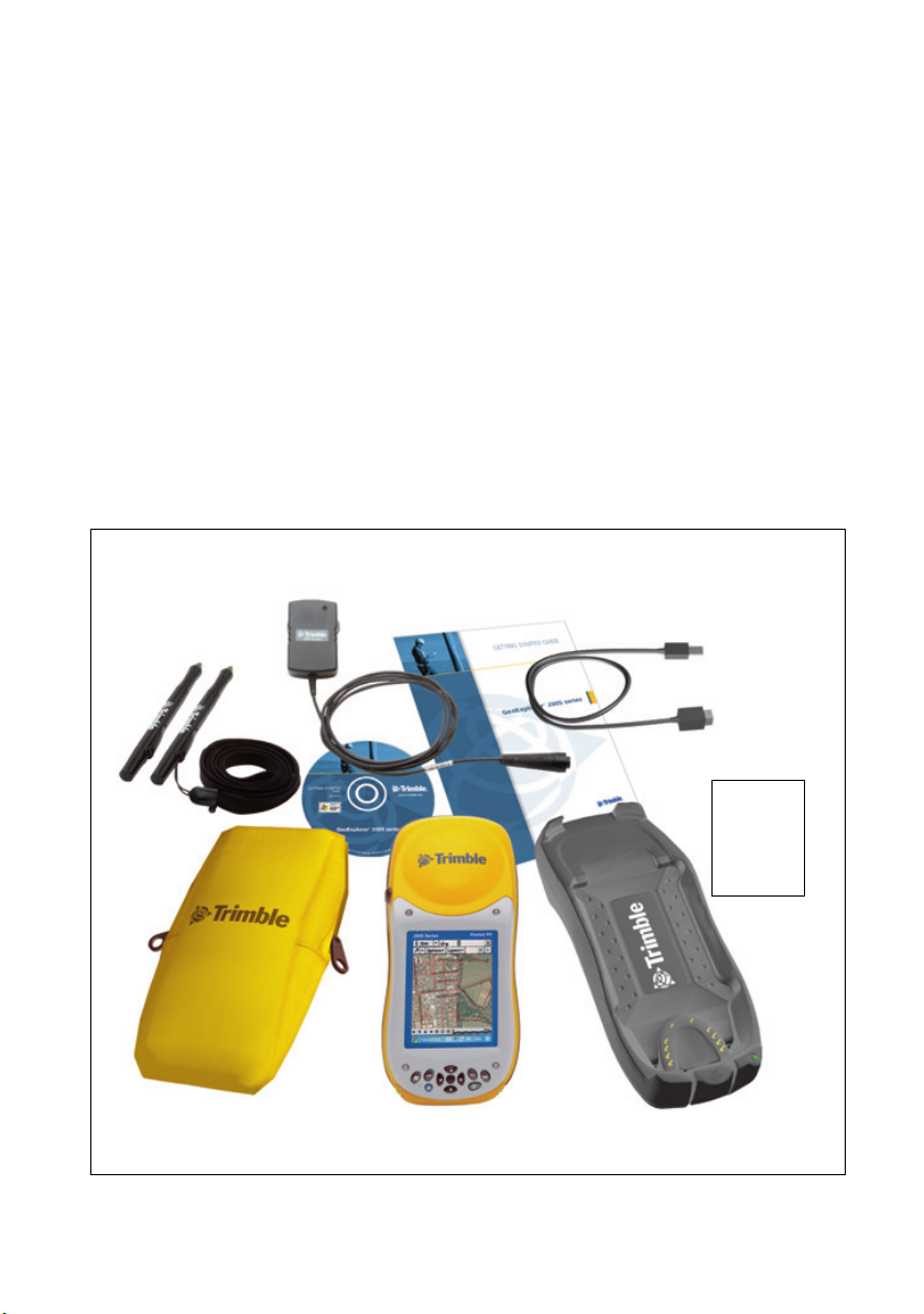
What’s in the box?
When you receive your GeoExplorer 2005 series handheld, check that
you have received all the components, as detailed on the packing list.
The standard components are shown below. Depending on the
system that you have purchased, you may have received additional
components.
Getting Started Guide
and Getting Started Disc
AC power adaptor
USB data cable
Screen protectors
(pack of 10)
Stylus (x2)
Pouch
GeoExplorer 2005
series handheld
2 GeoExplorer 2005 Series Getting Started Guide
Support
module
Page 21

Inspecting the system
Inspect all contents for visible damage (scratches, dents) and if any
components appear damaged, notify the shipping carrier. Keep the
shipping and packaging material for the carrier’s inspection.
Accessories
The following optional accessories are available:
System Components
• Power/serial clip
• Vehicle power adaptor
• External power kit
• Pole-mountable ground
plane
• Baseball cap with antenna
sleeve
• Screen protectors (10 pack)
• Stylus kit
• Backpack kit
1
Requires power / serial clip (sold separately)
2
Compatible with GeoXM/XT/XH handhelds for improved accuracy.
3
Compatible with GeoXH handheld for improved accuracy.
1
• Hard carry case
• Null modem cable
• GeoBeacon™ receiver (receives
differential corrections from a
beacon network)
• Range pole
• Range pole bracket
• External patch antennas
• Hurricane antenna kit
• Zephyr™ antenna kit
1
2
2
3
For more information, visit the Trimble website at
www.trimble.com/geoxm.shtml, www.trimble.com/geoxt.shtml, or
www.trimble.com/geoxh.shtml.
GeoExplorer 2005 Series Getting Started Guide 3
Page 22
System Components
Pre-installed software
The following software is pre-installed on the GeoExplorer 2005
series handheld:
Software Function
ActiveSync Synchronize information between the handheld and a
computer.
Calculator Perform basic arithmetic functions.
Calendar Keep track of appointments and arrange meetings.
Contacts Keep track of your friends and colleagues.
File Explorer View and manage files.
GPS Located in Settings / System, it allows you to configure
the NMEA port (COM2) to be used with more than one
application.
GPS Connector Configure communications between the handheld’s
integrated GPS receiver and external devices.
GPS Controller Configure and view status information for the
integrated GPS receiver.
Internet Explorer Browse the World Wide Web.
Messaging (Inbox) Write, send, and receive e-mail messages.
Notes Create handwritten, typed, or recorded notes.
Pictures and Videos Take, view, and edit pictures, as well as record and
launch video clips.
PowerPoint Mobile View slide show presentations.
Excel Mobile Create and edit Excel spreadsheets.
Word Mobile Create and edit Word documents.
Tasks Keep track of your tasks.
Windows Media Play Windows Media or MP3 audio and video files.
4 GeoExplorer 2005 Series Getting Started Guide
Page 23
System Components
Parts of the GeoExplorer 2005 series handheld
The following pages show the main features of the handheld.
Integrated GPS receiver
• High-performance
• Integrated SBAS (WAAS / EGNOS /
MSAS) receiver
• EVEREST multipath rejection technology
(GeoXT and GeoXH only)
• H-Star technology (GeoXH only) for
improved accuracy with shorter
occupation times
External antenna connector
Connection to an optional external GPS
antenna.
Integrated Bluetooth and WLAN
radios
• Connect to external devices using
Bluetooth™ wireless technology.
• Connect to networks and the Internet
using Wireless Local Area Network
(WLAN) connectivity.
Pocket PC
Field computer running Windows Mobile
Version 5.0 software for Pocket PC.
dvanced TFT color display
16-bit color (65,536 colors)
Interactive touch screen
¼ VGA display
Backlight
Keypad
Provides 11 buttons for fast, easy access to
common actions, including OK and Start.
Also provides Display and Power buttons,
and buttons for navigation (see page 7).
Microphone
Run Notes and use the Recording toolbar
to record.
SD card slot
Provides removable storage using SD (Secure Digital)
memory cards (see page 40).
GeoExplorer 2005 Series Getting Started Guide 5
Page 24
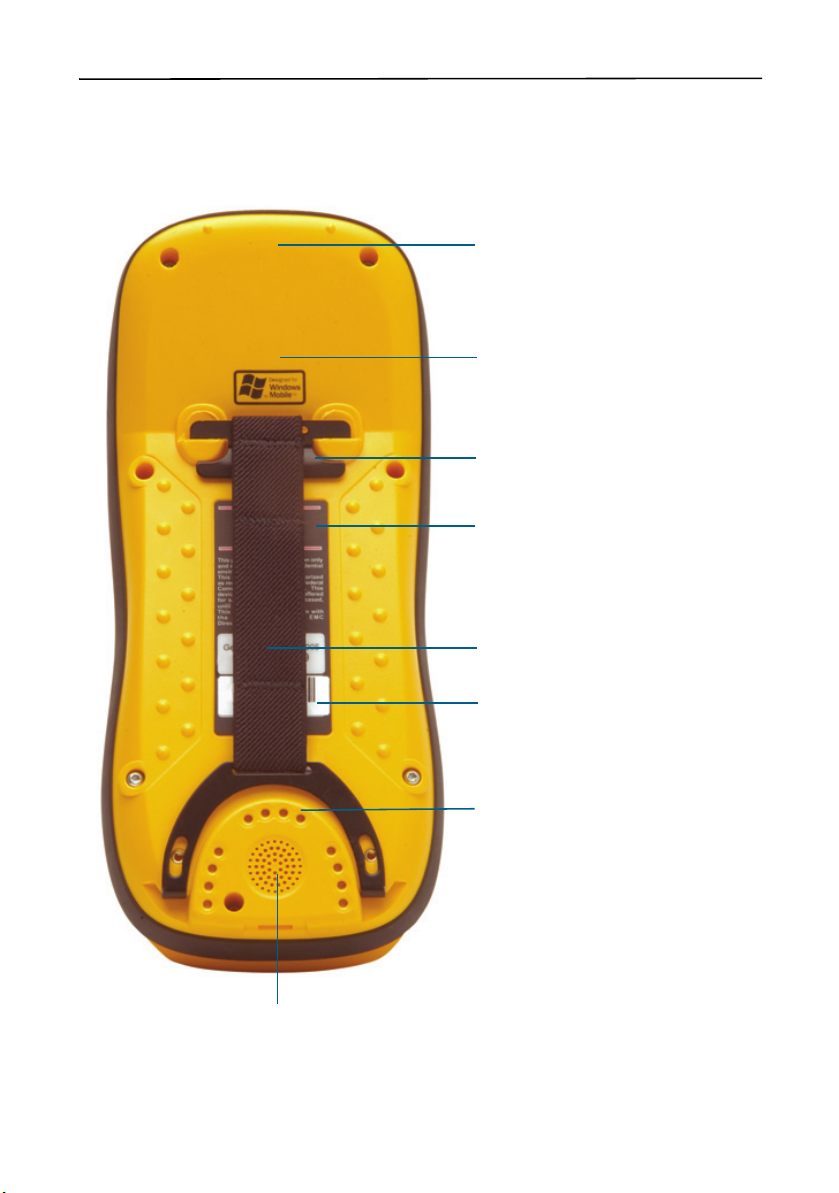
System Components
GPS COM ports
NMEA, TSIP, and real-time
communication with integrated GPS
receiver.
CPU
416 MHz Intel PXA-270 X-Scale
processor.
Main memory
64 MB RAM.
Flash Disk
• Internal flash memory
• Non-volatile
• 512 MB
Speaker
6 GeoExplorer 2005 Series Getting Started Guide
Handstrap
Internal battery
All-day operation with GPS.
Communication swipes
Place handheld in support module to:
• charge the battery
• provide USB or cabled Ethernet
connection to a computer
Attach optional serial clip to:
• charge battery
• provide external power
• connect to an external device such
as a GeoBeacon receiver or mobile
phone
Page 25
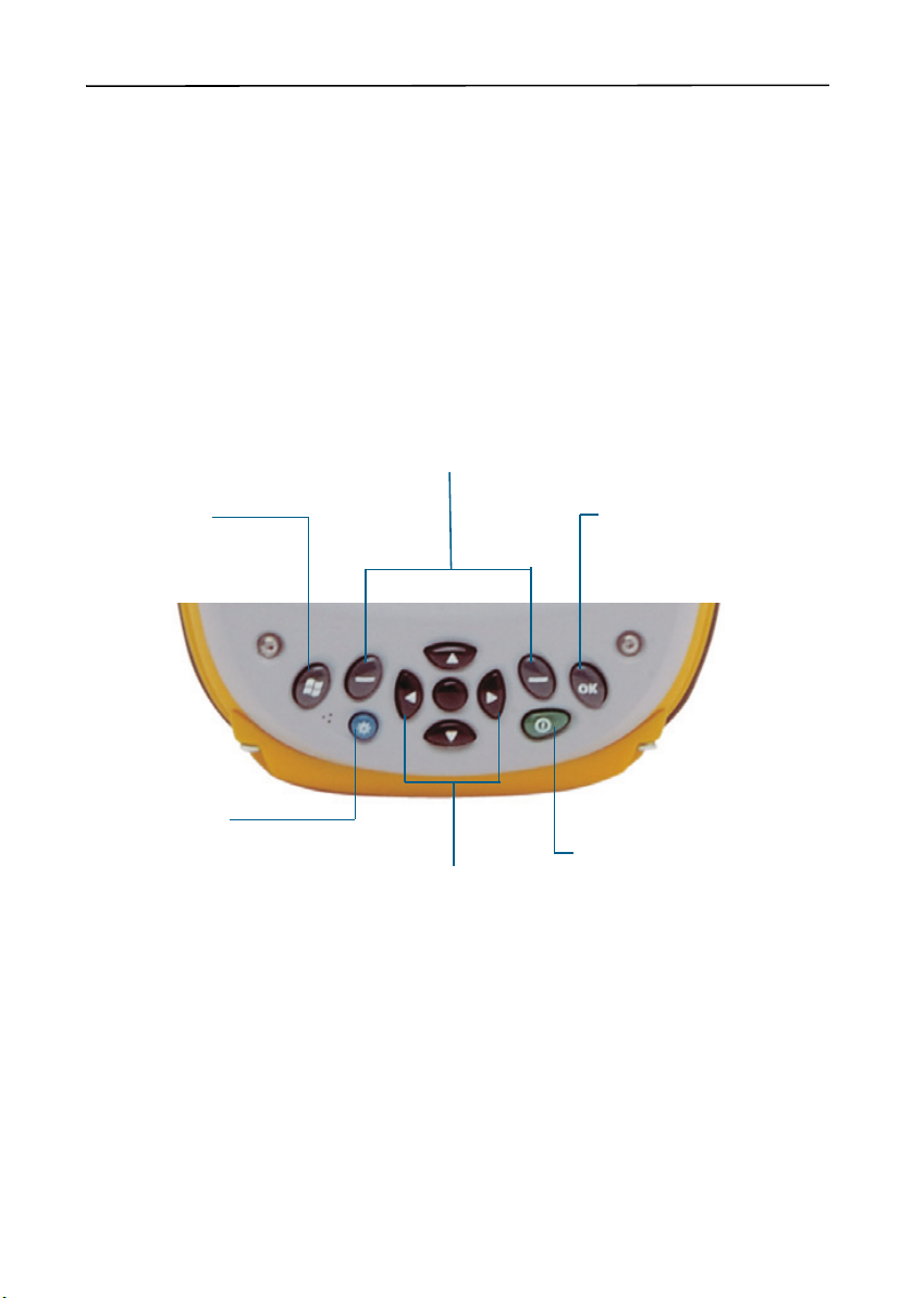
System Components
Keypad
Provides 11 buttons for fast, easy access to common actions. The
diagram below provides information about each button.
Application buttons
Perform application-specific actions.
• Left button: performs the same action as the softkey
on the left of the menu bar.
• Right button: performs the same action as the
softkey on the right of the menu bar
When no softkeys are shown in the menu bar, pressing
either application key has no effect.
Start button
Displays the
drop-down menu.
Display button
Press to turn on or
turn off the backlight.
Press the Display
button and the Start
button at the same
time to align the touch
screen (see page 9).
Start
Navigation buttons
Provide directional controls for
moving around the screen.
• Arrow buttons: move up,
down, left, and right.
• Action button: performs an
application-specific action,
usually Enter.
OK button
Press to select OK, Enter, or to
close an application.
Power button
Press to turn on the handheld, or
to put it into Suspend mode.
A 5-second press performs a soft
reset.
A 15-second press performs a
soft reset and powers off the
handheld.
GeoExplorer 2005 Series Getting Started Guide 7
Page 26
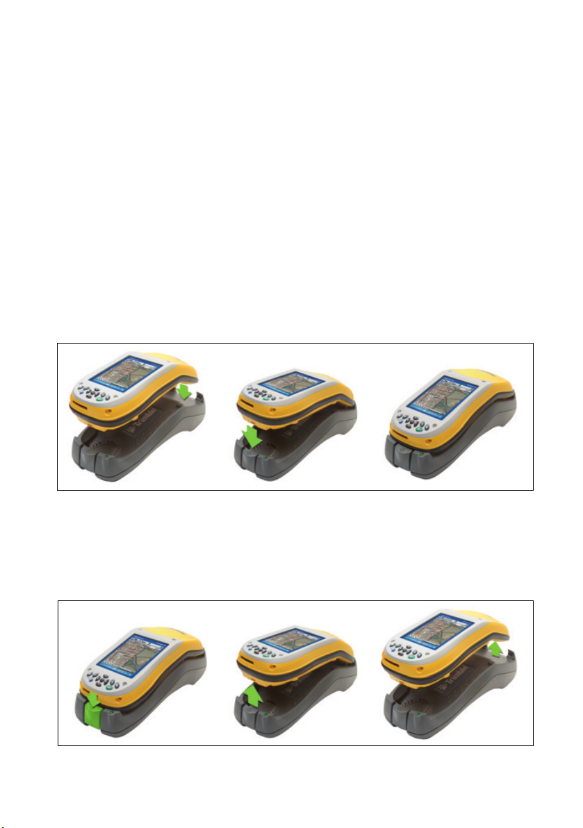
Getting Started 4
Follow the steps below to get started with the GeoExplorer 2005
series handheld. For information on using Windows Mobile
software, see Windows Mobile Basics, page 11.
Charge the battery
Before using the handheld for the first time, you must charge the
battery.
Connect one end of the AC adaptor cable to the support module and
the other to an AC power outlet. Put the handheld in the support
module as shown below.
Leave to charge for up to eight hours. For more information, see
Power, page 34.
To remove the handheld from the support module, press the release
button on the support module, then lift the bottom of the handheld
upward.
8 GeoExplorer 2005 Series Getting Started Guide
Page 27

Turn on and suspend
Press and release the Power button to turn on or to
suspend the handheld.
For more information, see Suspend mode, page 38.
Align the touch screen
The first time you turn on your handheld, you are prompted to align
the touch screen. Follow the on-screen instructions to align the touch
screen.
If at any time the touch screen does not respond properly to stylus
taps, realign it. To begin the alignment sequence, press the
button and the
Start button at the same time and follow the
on-screen instructions.
Turn on the backlight
Getting Started
Display
The touch screen is visible in all conditions,
including bright sunlight. Press the
Display
button to turn the backlight on or off.
To adjust the backlight, use the Backlight control
(see Backlight, page 75).
The
Display button overrides settings in the Backlight control. To
turn on the backlight again, use the
Display button.
GeoExplorer 2005 Series Getting Started Guide 9
Page 28

Getting Started
Set the time zone
To set the clock to your local time, the
handheld uses the GPS time reported
by the integrated GPS receiver and the
time zone that you specify. In the Today
screen, tap the clock icon . The Clock
Settings screen appears. Tap the Time
tab, select the Home option and then
select the correct time zone.
Install and activate software
Connect the handheld to a computer and use ActiveSync technology
to install or activate any software you need. For more information,
see Installing Software, page 19.
Use GPS
The integrated GPS receiver is switched off
until an application opens one of the GPS
COM ports. To use GPS, take the handheld
outside to a location with a clear view of the
sky. From the To da y screen, tap the GPS
softkey in the menu bar. The skyplot of the
default GPS software appears. Depending on
the software you have installed, this will be GPS Controller,
TerraSync, or the GPScorrect extension for ESRI ArcPad software. For
more information, see Using GPS, page 21.
10 GeoExplorer 2005 Series Getting Started Guide
Page 29
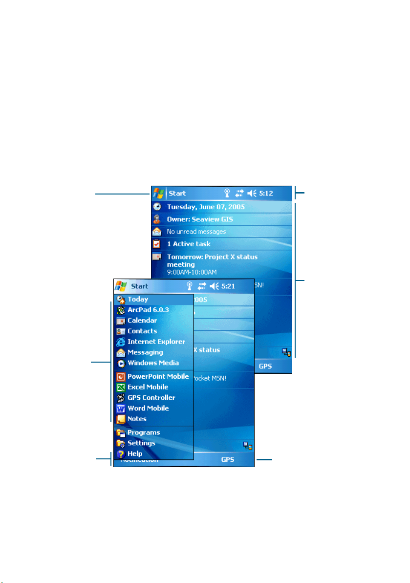
Windows Mobile Basics 5
The GeoExplorer 2005 series handheld’s operating system is based
on the Windows Mobile Version 5.0 software for Pocket PC.
Parts of the screen
The main parts of the screen are shown below.
Start button
Start
Tap to open the
where you can access
programs and system controls.
Start menu
Tap any item on
the menu to open
it.
Menu bar
Contains softkeys
providing access to
applications, menus,
and notifications.
menu,
Title bar
Contains status
icons for important
system functions.
Today screen
Summarizes your
appointments, tasks,
notes, and e-mails
for the day. Tap any
item to open it.
GPS softkey
Tap the GPS softkey, or press
the right application button
on the keypad, to open the
skyplot of the default GPS
software.
11 GeoExplorer 2005 Series Getting Started Guide
Page 30

Windows Mobile Basics
Accessing help
To access help, tap / Help or, if available, tap in the application
window. If there is an application running, context-sensitive help for
the current screen appears. To view the main Help Contents page, tap
the Contents softkey in the menu bar.
Help files installed on the handheld work in the same way as a Web
page. Tap hyperlinks to navigate around the help and use to
retrace your steps. Tap View /Contents to return to the Contents page
for the application, and tap View / All Installed Help to return to the
main Contents page.
Using the stylus
To interact with the handheld, use the stylus to tap on the touch
screen. There are three types of action you can perform with the
stylus:
Action Definition
Tap Touch the screen once with the stylus to open items
Tap and hold Tap and hold the stylus on an item to see a list of
Drag Hold the stylus on the screen and drag across the
and select options.
actions available for that item. On the pop-up menu
that appears, tap the action you want to perform.
screen to select text and images. Drag in a list to select
multiple items.
The stylus also provides a screwdriver under the cap that you can use
to remove and reattach the SD door (see SD memory cards, page 40).
12 GeoExplorer 2005 Series Getting Started Guide
Page 31

Entering text
The handheld does not have a physical keyboard. To enter text, use
an on-screen keyboard. Alternatively, you can write directly onto the
screen.
You can select how you want to enter text using the Input Panel. The
Input Panel automatically appears in the menu bar of any
application. The default selection is the on-screen keyboard.
To change the text input method:
1. In the menu bar, tap the arrow on the Input Panel button. (You
may have to activate and then hide the keyboard for the arrow to
appear.)
A list of input methods pops up. The currently selected method is
indicated by a check mark.
2. Tap the method you want to use to select it.
Using the on-screen keyboard
To activate the on-screen keyboard, tap
the keyboard icon on the Input
Panel displayed in the menu bar. The
on-screen keyboard appears.
Windows Mobile Basics
To enter text, tap the appropriate keys
on the on-screen keyboard. When you
Input panel showing
have finished entering text in a field,
tap to accept the text you have
entered and move to the next field.
To hide the keyboard, tap the keyboard icon again.
GeoExplorer 2005 Series Getting Started Guide 13
keyboard icon
Page 32

Windows Mobile Basics
Writing on screen
When you select Transcriber, you can write directly onto the screen
using the stylus. The Microsoft Transcriber software converts your
handwriting to text. You can use it to enter notes in a text editor such
as Notes.
To select Transcriber:
1. Tap the arrow on the Input Panel button displayed in the menu
bar. A list of input methods pops up.
2. Tap Tran scriber. The Transcriber Intro dialog appears.
3. Tap
OK.
The Transcriber icon appears in the menu bar, and the
Transcriber keyboard appears above the menu bar.
Transcriber keyboard
Input panel showing
Transcriber icon
Transcriber has a number of tools and modes that allow you to
customize how it works. These tools and modes are controlled from
the Transcriber keyboard. For more information, refer to the
Transcriber Help.
14 GeoExplorer 2005 Series Getting Started Guide
Page 33

ActiveSync Connections 6
You can use Microsoft ActiveSync technology to connect the
GeoExplorer 2005 series handheld to an office computer and
exchange information between the two devices.
This section provides information on:
• using ActiveSync technology
• connecting the handheld to a computer
ActiveSync version 4.0 and later is compatible with the GeoExplorer
2005 series handheld.
Note – If you do not have ActiveSync version 4.0 or later installed on
your computer, you can install it from the GeoExplorer 2005 Series
Getting Started Disc. To download the latest version, or a translated
version of ActiveSync, you can download it from the Microsoft website at
www.microsoft.com/windowsmobile.
Connecting the handheld to a computer
You can connect the handheld to a computer using the following:
• the support module connected to a USB port on a computer
• a Bluetooth wireless connection
Once the handheld and computer are physically connected, use
ActiveSync technology to establish a relationship between the two
devices.
Note – ActiveSync version 4.0 does not support connections to an office
computer using the serial clip, or a wireless LAN or cabled Ethernet
connection. For information on using these types of connections, see
Using the Optional Serial Clip, page 68, Using the WLAN Radio, page 63,
and Using Cabled Ethernet, page 66.
GeoExplorer 2005 Series Getting Started Guide 15
Page 34

ActiveSync Connections
Support module USB cabled connection
The support module provides a fast, simple USB connection between
the GeoExplorer 2005 series handheld and a computer. To connect to
a computer using a USB connection:
1. Connect the USB data cable to the USB port on the support
module.
Place the handheld in the support module. For information about
how to do this, see Getting Started, page 8.
2. Connect the other end of the USB data cable to a USB port on the
computer.
Bluetooth wireless connection
You can use the GeoExplorer 2005 series handheld’s integrated
Bluetooth radio to establish a wireless serial connection to a
Bluetooth-enabled office computer. See Using the Bluetooth Radio,
page 51.
16 GeoExplorer 2005 Series Getting Started Guide
Page 35

Using ActiveSync technology
You can use ActiveSync technology to:
• Synchronize information between a computer and the handheld
so that you have the latest information in all locations.
• Change synchronization settings so that synchronization occurs
automatically.
• Copy files between the handheld and a computer.
• Install software applications onto the handheld.
Note – If you do not have ActiveSync version 4.0 or later installed on
your computer, you can install it from the GeoExplorer 2005 Series
Getting Started Disc. To download the latest version, or a translated
version of ActiveSync, you can download it from the Microsoft website at
www.microsoft.com/windowsmobile.
To use ActiveSync technology:
1. If necessary, install ActiveSync version 4.0 or later on the
computer.
2. Connect the handheld to the computer (see page 15). The
Synchronization Setup Wizard appears automatically.
ActiveSync Connections
GeoExplorer 2005 Series Getting Started Guide 17
Page 36

ActiveSync Connections
Note – If the connection is not made automatically, check that the
connection has been enabled in the ActiveSync software and on the
handheld. For more information, see Troubleshooting, page 78.
3. Follow the instructions on the office computer screen to connect
the handheld to the computer. You can establish two types of
connections with ActiveSync: a partnership or a guest
relationship.
Information about a partnership is stored permanently on the
computer. You can use a partnership to synchronize files between
the handheld and a computer. If you are going to connect to the
same computer regularly, you should establish a partnership. A
guest relationship lasts only as long as the handheld and the
computer are connected.
4. If you selected a
partnership, use the
ActiveSync software
to configure the
synchronization
settings for your
selected applications
( for example,
Messaging or
Calendar).
For more information,
refer to the ActiveSync
Help.
B
18 GeoExplorer 2005 Series Getting Started Guide
Tip – If you have GPS Pathfinder® Office software version 3.10 or later
installed on your office computer, you can configure the Connection
Manager utility in the GPS Pathfinder Office software to automatically
detect when you connect a GeoExplorer 2005 series handheld to the
computer. This will enable you to automatically transfer data from
TerraSync software, differentially correct the data, and then export it to
a GIS. For more information, refer to the GPS Pathfinder Office Help.
Page 37

Installing Software 7
The GeoExplorer 2005 series handheld supports software designed to
run on Windows Mobile-based devices. You may also be able to
install and run some software designed for other operating systems.
To install software on the handheld, first establish an ActiveSync
connection to a computer (see ActiveSync Connections, page 15).
Then follow the installation instructions that are provided with the
software. If no instructions are provided, run the program file (.exe
file) on a computer:
• If the file is an installer, the installation wizard will begin. Follow
the instructions on the screen. Once the software is installed on
the computer, the installer will automatically transfer it to the
handheld.
• If the file is not an installer, an error message appears, stating that
the program is valid but designed for a different type of computer.
Use ActiveSync technology to copy the file to the Program Files
folder on the handheld.
Note – If an SD (Secure Digital) memory card is inserted in the
handheld, the card appears as an installation location option. Trimble
recommends that you install software to the handheld’s flash disk, not to
an SD memory card. If you install software to a card and then remove
the card from the handheld, the software will not be available for use.
Installing TerraSync software
You can install version 2.52 or later of the TerraSync software on a
GeoExplorer 2005 series handheld.
To install the TerraSync software, either insert the TerraSync Software
CD in the CD-ROM drive of a computer and use the menus provided,
or run the downloaded setup file. To obtain a serial number for
installation, you must register your copy of the software online.
Detailed installation instructions are provided in the Te rraS yn c
Software Release Notes.
GeoExplorer 2005 Series Getting Started Guide 19
Page 38

Installing Software
Installing ArcPad software
You can install version 6.0.3 of the ESRI ArcPad software on a
GeoExplorer 2005 series handheld. Detailed installation instructions
for ESRI ArcPad are provided in the ArcPad documentation.
Note – You must install the ArcPAD 6.0.3 QFE patch after installing the
software. This patch fixes display issues seen in Windows Mobile
software. For more information, visit http://support.esri.com/index.cfm,
select the Downloads tab and then select the Patches and Service Packs
link.
Installing the GPScorrect extension
You can install version 1.11 or later of the Trimble GPScorrect
extension for ESRI ArcPad software on a GeoExplorer 2005 series
handheld. Make sure you install version 6.0.3 of the ArcPad sofware
before you install the GPScorrect extension.
To install the GPScorrect extension, either insert the Trimble
GPScorrect Extension for ESRI ArcPad Software CD in the CD-ROM
drive of a computer and use the menus provided, or run the
downloaded setup file. Detailed installation instructions are provided
in the GPScorrect Extension Release Notes.
Using the GPS Analyst extension
You can also use the GeoExplorer 2005 series handheld with the
™
Trimble GPS Analyst
the GeoExplorer handheld to a Tablet PC or laptop running version
1.20 or later of the GPS Analyst extension and use the handheld as
your GPS receiver. Run ArcMap software, and use the GPS Analyst
extension to collect GPS data.
20 GeoExplorer 2005 Series Getting Started Guide
extension for ESRI ArcGIS software. Connect
Page 39

Using GPS 8
The GeoExplorer 2005 series handheld provides an integrated GPS
receiver that enables you to use GPS data.
Note – Before you can use GPS, you may need to configure the
application to connect to GPS (see Configuring a GPS application,
page 23).
This section provides information on:
• getting a clear view of the sky (see page 22)
• GPS COM ports (see page 22)
• configuring a GPS application to connect to GPS (see page 23)
• configuring GPS quality control settings to suit your requirements
and the current GPS conditions (see page 24)
• using mission planning to identify the best times of the day for
working with GPS (see page 26)
• using real-time differential corrections for better accuracy
(see page 28)
• the level of accuracy provided by GeoExplorer 2005 series
handhelds (see page 29)
• factors that affect accuracy and how to improve accuracy
(see page 30)
• differential GPS (see page 32)
What is GPS?
The Global Positioning System (GPS) is a satellite-based positioning
system operated by the U.S. Department of Defense (DoD). A
constellation of operational NAVSTAR satellites orbit the earth every
12 hours, providing worldwide, all-weather, 24-hour time and
position information.
For more information about how GPS works, visit the Trimble
website at www.trimble.com/gps/.
GeoExplorer 2005 Series Getting Started Guide 21
Page 40

Using GPS
Getting a clear view of the sky
To receive signals from GPS satellites, the receiver must have a clear
view of the sky. GPS does not work indoors. Hold the handheld with
the screen toward you. The internal antenna is located above the
screen under the Trimble logo. You do not have to hold the handheld
perfectly level, but keep the antenna facing upward, not downward or
sideways.
Anything that blocks light also blocks signals. Satellite signals can be
blocked by people, buildings, heavy tree cover, large vehicles, or
powerful transmitters. GPS signals can go through leaves, plastic, and
glass, but these all weaken the signal.
GPS COM ports
The integrated GPS receiver has three COM ports for communicating
with software on the handheld and with external devices.
Using GPS is as simple as opening the appropriate GPS COM port.
Each port is used for a particular type of communication:
Port Function Description
COM2 NMEA Outputs NMEA-0183 messages. NMEA is a standard
GPS communication protocol used by most GPS
applications.
The handheld outputs the following NMEA messages:
GGA, GLL, GSA, GSV, RMC, VTG, ZDA. All messages are
output at a one second interval.
COM3 TSIP Outputs and receives TSIP messages. TSIP (Trimble
Standard Interface Protocol) is used by Trimble GPS
applications, and is also supported by some other GPS
applications.
COM4 Real-time Receives RTCM real-time correction messages. If you
are using an external correction source connected to
COM1 or a Bluetooth port, the corrections must be
redirected to COM4. For more information, see Using
real-time corrections from other sources, page 28.
Note – COM1 is a standard serial port that connects to external devices.
For more information, see Using the Optional Serial Clip, page 68.
22 GeoExplorer 2005 Series Getting Started Guide
Page 41

Using GPS
Configuring a GPS application
The first time you use GPS software on the handheld, you may need
to specify which GPS COM port to connect to. Specify COM2 if the
software uses NMEA, or COM3 if the software uses TSIP. If you are
not sure which protocol to use, check the documentation for the
software.
If you are using … do this …
GPS Controller Run GPS Controller. The software automatically activates the
integrated GPS receiver on COM3.
TerraSync Run Terrasync. The software automatically activates the
integrated GPS receiver on COM3.
ArcPad with the
GPScorrect extension
ArcPad 1. In ArcPad, tap the
1. Within ArcPad, tap the
activates the integrated GPS receiver on COM3.
2. If you want to configure GPS and real-time, or view status
information, run the GPScorrect extension. In the Trimble
toolbar, tap the
2. In the Protocol field select NMEA 0183.
3. Tap the GPS tab and from the Port field select COM2.
4. Tap
5. Tap the
OK.
GPS button . The software activates the
integrated GPS receiver.
GPS button . The software
GPScorrect button.
Tools button .
B
NMEA application Configure the software to connect to GPS on COM2, then use
the Connect or Activate GPS command.
TSIP application Configure the software to connect to GPS on COM3, then use
the Connect or Activate GPS command.
Tip – ArcPad can also connect using the TSIP protocol.
However, if you use the NMEA protocol, you can run
GPS Controller at the same time for advanced GPS and
real-time configuration and status information.
Only software that is running on the handheld can connect directly to
a GPS COM port. To supply GPS data to an external device, use GPS
Connector to redirect the output from the appropriate GPS COM
port to the serial port (COM1) or to a Bluetooth port. Then configure
the external device to connect to that serial or Bluetooth port. For
more information, see GPS Connector, page 28.
GeoExplorer 2005 Series Getting Started Guide 23
Page 42

Using GPS
Using your GPS application
By default, the handheld is configured to receive satellite signals in
most conditions. The GPS Controller software is pre-installed on all
GeoExplorer 2005 series handhelds to enable you to check the
current GPS status, or to configure the integrated GPS receiver.
To run GPS Controller, do one of the following:
• From the Today screen, tap the GPS softkey in the menu bar.
• Tap / Programs / GPS Controller.
Note – GPS Controller duplicates the status and setup features of
TerraSync software and the GPScorrect extension for ESRI ArcPad
software. If one of these applications is installed, it runs instead of GPS
Controller when you tap the GPS softkey in the menu bar of the Today
screen. For more information about these applications, refer to the
documentation for the application.
Use the graphical Skyplot section or the
Satellite Info section to view detailed
GPS information, and to adjust the
quality and yield of the GPS positions
you are receiving.
The GPS Controller software includes a
Plan section for mission planning (see
Planning a data collection session,
page 26) and a Real-time section for
configuring and monitoring real-time
correction sources (see Using real-time
corrections from other sources,
page 28).
For more information on any GPS Controller section or function,
refer to the GPS Controller Help.
24 GeoExplorer 2005 Series Getting Started Guide
Page 43

Using GPS
Configuring GPS settings
Use the GPS Settings form in the GPS Controller software to configure
the settings you require for GPS positions.
To open the GPS Settings form, do one of the following:
• Ta p GPS Settings in the Setup section.
• Tap in the Skyplot, Satellite Info, or Plan section.
Selecting predefined settings using the GPS slider
Use the GPS slider to select predefined settings.
To use the slider, select the slider check box. The slider control
appears on the GPS slider, and some fields in the form become
read-only. The values in these fields change as the slider control
position changes.
Drag the slider control to the left to decrease the GPS precision and
include more satellites in GPS position calculations. Drag it to the
right to increase the GPS precision and exclude satellites that do not
meet the precision requirements from GPS position calculations. For
more information, see Factors that affect accuracy, page 30.
Selecting custom GPS settings
To select custom GPS settings, clear the slider check box. The slider
control disappears from the GPS slider, and the remaining fields
change to editable numeric fields. To specify the required GPS
settings, enter values in these fields.
Configuring velocity filtering
You can use velocity filtering to smooth GPS positions when
collecting lines or areas in high multipath environments. To apply
velocity filtering, you must:
1. Configure Velocity Filtering to Auto on the GPS Settings form.
2. Use real-time corrections, or collect data with SuperCorrect set to
On in the TerraSync software or GPScorrect extension.
GeoExplorer 2005 Series Getting Started Guide 25
Page 44

Using GPS
Resetting GPS
Trimble GPS applications all have options to reset the receiver to:
• delete the almanac
• delete information stored on the last known position
• restart the receiver
• reset the GPS receiver to factory defaults
Planning a data collection session
To maximize productivity, plan GPS
data collection around the times of the
day when satellite geometry is best.
The GPS Controller software includes a
Plan section with an animated skyplot
and DOP (satellite geometry) graph for
your position for the next 12 hours.
In the Plan section, you can check the
planning skyplot as you play a session,
then use the timeline to zoom in on
times when geometry is poor. As you
adjust GPS settings, the Plan section is
updated, so you can see the effect of
different quality control settings.
Note – If TerraSync software or the GPScorrect extension for ArcPad is
installed, use the planning feature in that application instead of the GPS
Controller software.
26 GeoExplorer 2005 Series Getting Started Guide
Page 45

Using GPS
Using SBAS corrections
The GeoExplorer 2005 series handheld has an integrated receiver
that uses Satellite Based Augmentation Systems (SBAS) correction
messages to improve the accuracy and integrity of GPS data.
The receiver tracks SBAS satellites according to their geographical
location:
• Wide Area Augmentation System (WAAS) satellites between
40° W and 180° W, and between 10° N and 90° N.
• European Geostationary Navigation Overlay Service (EGNOS)
satellites between 40° W and 60° E, and between 10° N and 90° N.
• MTSAT Satellite-based Augmentation System (MSAS) satellites
between 120° E and 165° E.
You can use the default zones, or configure the receiver to use
particular SBAS satellites in the Integrated SBAS Settings form.
To use SBAS corrections:
1. In the GPS Controller software,
open the Real-time section and tap
the
Setup button .
2. In the Choice 1 field, select
Integrated SBAS. To select
particular satellites, tap the
button next to the Choice 1 field.
Setup
3. In the Choice 2 field, specify
whether to use uncorrected
positions, or to stop using GPS
positions, if corrections are not
available.
4. Tap
OK.
Note – If TerraSync software or the GPScorrect extension for ArcPad is
installed, configure real-time settings in that application instead of the
GPS Controller software.
GeoExplorer 2005 Series Getting Started Guide 27
Page 46

Using GPS
Using real-time corrections from other sources
You can use corrections from an external correction source, such as a
GeoBeacon receiver, a DGPS radio, or a mobile phone. The external
correction source can be connected to a Bluetooth port or to the
optional serial clip (COM1). Use the GPS Controller software to set up
and monitor the real-time input source that you want to use.
Note – If TerraSync software or the GPScorrect extension for ArcPad is
installed, configure real-time settings in that application instead of the
GPS Controller software.
The integrated GPS receiver communicates only through its GPS
COM ports (COM2, COM3, and COM4). Input from an external
correction source connected to COM1 or to a Bluetooth port must be
redirected to the real-time GPS COM port (COM4). Trimble
applications, such as GPS Controller, handle the redirection
automatically. If you are using any other application to set up and
monitor real-time sources, use GPS Connector to redirect the input
to COM4 (see below).
GPS Connector
The GPS Connector software is
pre-installed on all GeoExplorer 2005
series handhelds. To o p e n GP S
Connector, tap
/ Settings / Connections / GPS
Connector.
The GPS Connector software lets you
connect the GPS COM ports to COM1
or Bluetooth ports and configure port
settings such as the baud rate. GPS
Connector software has a graphical
display that shows all active
connections, and a text display that
shows connection messages.
28 GeoExplorer 2005 Series Getting Started Guide
Page 47

Use the GPS Connector software to
output NMEA or TSIP messages from
the integrated GPS receiver to another
device, such as an external data
collector.
Note – If you are using a Bluetooth port,
enable and configure the Bluetooth Serial
Port service before you connect to the
port.
The connections that you create in the
GPS Connector software are only active
while the software is running.
Connections created by the GPS
Connector software are labeled GPS Connector in the status screen
and end when you exit the software.
For more information, refer to the GPS Connector Help.
Antennas
Using GPS
The GeoExplorer 2005 series handheld has an internal antenna,
which is suitable for use in most conditions. You can also connect a
Hurricane or an external patch antenna for when you work in a
vehicle. For improved yield under canopy, you can use a patch
antenna with a Hurricane antenna or a ground plane.
If you have a GeoXH handheld, you can connect an external Zephyr
antenna for improved accuracy when you collect data using H-Star
technology (see Maintaining Accuracy below).
Maintaining Accuracy
GeoExplorer 2005 series handhelds are high performance GPS
receivers that calculate very accurate GPS positions. The GeoXM
handheld provides reliable accuracy within 1 to 3 meters. The GeoXT
and GeoXH handhelds use EVEREST multipath rejection technology
to provide submeter accuracy.
GeoExplorer 2005 Series Getting Started Guide 29
Page 48

Using GPS
Note – All accuracy figures are for both real-time and postprocessed
differentially corrected positions, unless otherwise stated.
In addition, the GeoXH handheld enables you to use H-Star
technology to provide to obtain 30 cm (subfoot) postprocessed
accuracy for static GPS positions. Using an external Zephyr antenna,
the GeoXH receiver is capable of providing postprocessed accuracy of
20 cm (8 inches) or better for static GPS positions.
Note – Accuracy estimates for streaming (dynamic) GPS positions may
be larger than 20 cm (using the external Zephyr antenna) or 30 cm
(using the internal antenna).
Factors that affect accuracy
As discussed above, the accuracy that you obtain from your
GeoExplorer 2005 series handheld is affected by the receiver model,
the type of antenna used, whether the data is differentially corrected
in real-time or after data collection, and whether you are logging a
point feature using static GPS positions, or a line or area feature using
streaming GPS positions.
The table below lists several other factors that affect the accuracy
obtained from your receiver, and recommends ways to minimize
their effect.
Factor Description To Maximize Accuracy
Number of
visible
satellites
Multipath Multipath is when GPS
30 GeoExplorer 2005 Series Getting Started Guide
The accuracy of your data
increases with the number of
satellites being used to
calculate the position.
satellite signals are reflected
off nearby objects, such as
buildings or cars, causing an
erroneous signal to be
received by the GPS antenna.
This can cause errors of several
meters.
You need at least four satellites to
calculate an accurate 3-dimensional
position. Trimble data collection
software only logs GPS positions when
four or more satellites are visible.
Tracking more satellites can help to
lower DOP values.
To reduce multipath, collect data in an
open environment away from large
reflective surfaces and with a clear
view of the sky. In high multipath
environments, record velocity data and
use velocity filtering when
postprocessing the data.
Page 49

Factor Description To Maximize Accuracy
Poor satellite
geometry
Dilution of Precision (DOP) is a
measure of the quality of GPS
positions, based on the spread
(geometry) of the satellites in
the sky that are used to
compute the positions. When
satellites are widely spaced
relative to each other, the
PDOP value is lower, and
position accuracy is greater. If
the view of the sky is partially
blocked, or if all of the
satellites are in one area of
the sky, the geometry and
DOP may be poor.
Set your GPS application to ignore
positions with a poor DOP value.
You can choose to filter positions
based on PDOP (Position Dilution of
Precision) or HDOP (Horizonal Dilution
of Precision). PDOP is a measure of the
horizontal and vertical quality of the
GPS positions, whereas HDOP is just a
measure of the horizontal precision (x
and y coordinates).
Select HDOP rather than PDOP if you
want to ensure positions are accurate
horizontally, and when vertical
accuracy is less important
Trimble recommends a maxiumum
PDOP setting of 6, or a maximum
HDOP setting of 4.
Weak
satellite
signals
Signal-to-Noise Ratio (SNR) is a
measure of the strength of the
satellite signal relative to the
background noise. Accuracy
Set your GPS application to ignore
satellites with a weak SNR.
Trimble recommends a minimum SNR
setting of 39 dBHz.
degrades as the signal
strength decreases. Weak
signals may be caused by
signals coming through
vegetation, multipath signals,
or low satellite elevation.
Satellite
elevation
When a satellite is low on the
horizon, satellite signals must
travel farther through the
atmosphere. This results in a
lower signal strength and
Set the elevation field in your data
collection software to ignore satellites
that are low in the sky.
Trimble recommends a minimum
elevation setting of 15°.
delayed reception by the GPS
receiver, which can cause
errors in calculating the
position.
Occupation
time at a
point
Occupation time is the time
spent at a point logging GPS
positions.
For point features, remain at the
feature and log a number of GPS
positions to obtain an averaged
position.
When collecting line and area features,
collect them using averaged vertices.
Using GPS
GeoExplorer 2005 Series Getting Started Guide 31
Page 50

Using GPS
Differential GPS
Use differential GPS to correct errors in your collected data.
Differential GPS (DGPS) requires two or more receivers. One receiver,
called the reference station, is located at a known point to determine
the GPS measurement errors and compute corrections to these
errors. An unlimited number of mobile GPS receivers, called rovers,
collect GPS data at unknown locations within the vicinity of the
reference station. Errors common at both the reference and rover
receivers are corrected with DGPS either in real time or during
postprocessing.
Real-time DGPS
In real-time DGPS, the reference station calculates and broadcasts
the error for each satellite as each measurement is received, enabling
you to immediately see differentially corrected data on the map
displayed in the data collection software.
Real-time DGPS sources include external beacon and radio sources,
as well as Satellite Based Augmentation Systems (SBAS) such as
WAAS in the US and EGNOS in Europe, and Virtual Reference Station
™
(VRS
stations in a network to calculate the DGPS corrections which are
then delivered to the user from a Geostationary satellite (SBAS) or
from a radio or cell phone (VRS).
) systems. SBAS and VRS systems use multiple reference
Factors that affect real-time DGPS accuracy include how often the
corrections are updated, and whether the coordinate system used by
the correction source matches the coordinate system used by the
GPS receiver.
Postprocessed DGPS
In postprocessed DGPS, the collected GPS data is transferred to an
office computer, and measurements from the reference station are
downloaded. Postprocessing software such as the GPS Pathfinder
Office software or the Trimble GPS Analyst extension for ESRI ArcGIS
software is used to differentially correct the collected data.
32 GeoExplorer 2005 Series Getting Started Guide
Page 51

Using GPS
Postprocessed DGPS typically uses only one reference station,
however, when differentially correcting data collected with GeoXH
receivers using H-Star technology, you can select multiple reference
stations to correct the file against for improved accuracy.
Factors that affect the accuracy of postprocessed DGPS include the
distance between the reference station and the location where the
rover data was collected, the accuracy of the reference station
position, and the logging interval at the reference station.
For more information, refer to the documentation provided with your
postprocessing software.
Postprocessed real-time DGPS
Postprocessed DGPS positions are generally more accurate than
DGPS positions obtained in real time. If you collect SuperCorrect
records, or H-Star data with the ProXH receiver, as well as GPS
positions using the TerraSync software or the GPScorrect extension,
or using applications developed using the GPS Pathfinder Tools SDK,
you can postprocess your files in the GPS Pathfinder Office software
or the Trimble GPS Analyst extension to improve accuracy.
Note – For more information about GPS and DGPS, review the All About
GPS tutorial available from the Trimble website at
www.trimble.com/gps.
GeoExplorer 2005 Series Getting Started Guide 33
Page 52

Power 9
When fully charged, the internal battery of the handheld provides
enough power for a full working day using GPS. To extend the time
between charges, use the optional vehicle power adaptor
(P/N 61235-00) or the external power kit (P/N 57123-00). Use the
support module with the AC adaptor (P/N 61234-00) supplied with
the international adaptor kit to recharge the internal battery.
Safety warnings
Battery safety
C
WARNING – The GeoExplorer 2005 series handheld is powered by an
internal rechargable Lithium-ion battery. Charge and use the battery
only in strict accordance with the instructions provided.
To prevent injury or damage:
- Never attempt to remove, replace, or repair the battery yourself.
- Do not damage the battery.
- Do not store or leave your device near a heat source such as near a
fireplace or other heat-generating appliance, or otherwise expose it
to temperatures in excess of 70°C (158°F) such as on a vehicle
dashboard. When heated to excessive temperatures, battery cells
could explode or vent, posing a risk of fire.
- Do not use the handheld if the battery appears to be leaking.
- If the battery requires attention, send the handheld to your local
Trimble Service center.
- Discharge the handheld before disposing of the battery. When
disposing of the battery, be sure to do so in an environmentally
sensitive manner. Adhere to any local and national regulations
concerning battery disposal or recycling.
34 GeoExplorer 2005 Series Getting Started Guide
Page 53

AC adaptor safety
Power
C
WARNING – To use AC adaptors safely:
- Use only the AC adaptor intended for the GeoExplorer 2005 series
handheld. Using any other AC adaptor can damage your product
and may void your warranty. Do not use the AC adaptor with any
other product.
- Make certain that the input voltage on the adaptor matches the
voltage and frequency in your location.
- Make certain that the adaptor has prongs compatible with your
outlets.
- AC adaptors are designed for indoor use only. Avoid using the AC
adaptor in wet outdoor areas.
- Unplug the AC adaptor from power when not in use.
- Do not short the output connector.
- There are no user-serviceable parts in this product.
- Should damage to the AC adaptor occur, replace it with a new Trimble
AC adaptor (P/N 61234-00).
Charging the internal Lithium-ion battery
The rechargeable Lithium-ion battery is supplied partially charged.
Charge the battery completely before using it for the first time. If the
battery has been stored for longer than six months, charge it before
use. Trimble recommends charging the battery for eight hours to
recharge it fully.
An international adaptor kit is provided with the GeoExplorer 2005
series handheld. To charge the handheld’s internal battery, use the
international adaptor kit connected to either the support module or
the optional serial clip.
Note – The GeoExplorer 2005 series handheld is not compatible with the
AC adaptor or support module supplied with previous versions of the
handheld (and vice versa). You must use the AC power adaptor
(P/N 61234-00) and support module (P/N 53500-00) provided with the
GeoExplorer 2005 series handheld.
GeoExplorer 2005 Series Getting Started Guide 35
Page 54

Power
To charge the internal battery using the support module:
1. Use the AC power adaptor to connect the
support module to mains power.
2. Place the handheld in the support
module.
3. Leave for up to eight hours to recharge.
Note – The Power settings screen always shows 100% power for the
backup battery. The handheld does not have a backup battery installed.
Using the support module with the AC power adaptor recharges the
internal battery. In the office, leave the GeoExplorer 2005 series
handheld in the support module to conserve the battery.
If you are not going to use the handheld for some time, either keep
the handheld connected to mains power to continually charge it, or
fully charge the handheld and switch it off. See Storage, page 77.
Using external power
Use the optional serial clip
to connect the GeoExplorer
2005 series handheld to an
external power source.
Depending on the optional
accessories that you have
purchased, you can use
mains power, the external
power kit, or a vehicle’s
battery to supply power to
the handheld.
To connect to an external power source:
1. Attach the serial clip (P/N 53550-00) to the handheld.
2. Plug the appropriate cable into the power port on the serial clip.
36 GeoExplorer 2005 Series Getting Started Guide
Page 55

Note – The GeoExplorer 2005 series handheld is not compatible with the
serial clip supplied with previous versions of the handheld. You must use
the gray serial clip (P/N 53550-00) provided with the GeoExplorer 2005
series handheld.
3. Connect the other end of the cable to the external power source.
To use power from … connect this … to …
AC power source (mains power) AC power adaptor supplied
with the handheld
external power kit battery adaptor cable from optional
external power kit
(P/N 57123-00)
vehicle battery optional vehicle power
adaptor (P/N 61235-00)
AC power outlet
Lithium-ion battery
provided as part of
external power kit
vehicle’s cigarette
lighter socket
Note – You must use the vehicle power adaptor (P/N 61235-00) or the
Lithium-ion battery supplied with the external power kit (P/N 57123-00)
provided with the GeoExplorer 2005 series handheld. These
components are not compatible with previous versions of the
GeoExplorer series handheld. Likewise, the GeoExplorer 2005 series
handheld is not compatible with the 12V vehicle power adaptor or the
12V lead acid camcorder battery supplied with the external power kit
used with previous versions of the handheld.
Power
Recharging from an external power source
By default, the GeoExplorer 2005 series handheld recharges its
internal battery from any external power source that is connected.
Recharging the battery draws more power from the external source
than is used to power the handheld.
GeoExplorer 2005 Series Getting Started Guide 37
Page 56

Power
Suspend mode
When you press the Power button to turn off the handheld, the
handheld goes into Suspend mode. This is a low-power mode that
maintains the main memory contents but does not allow you to
operate any of the handheld’s functions. The handheld appears to be
turned off. The integrated GPS receiver is turned off and any
application using GPS is disconnected.
To turn on the handheld when it is in Suspend mode, press the
Power button. The handheld is ready for operation. There may be a
delay of up to 30 seconds while the integrated GPS receiver
automatically reactivates.
You can configure the handheld to automatically enter Suspend
mode when it has been idle for a specified time. By default, the
handheld is set to enter Suspend mode if the handheld is not used for
three minutes.
To change the time to enter Suspend mode:
1. Tap / Settings / System / Power.
2. Tap the Advanced tab.
3. From the On battery power group,
select the Turn off device if not used
for check box and select the idle time
from the drop-down list.
4. Tap
38 GeoExplorer 2005 Series Getting Started Guide
OK.
Page 57

Conserving power
Although the handheld battery can operate for a full day without
recharging, you should try to conserve battery power as much as
possible. Follow these tips to reduce power consumption:
Power saving tips
B
• Set the handheld to automatically enter Suspend mode when idle. For
more information, see Suspend mode, page 38.
• Turn off the integrated Bluetooth or WLAN radios whenever you are
not using them. For more information, see Using the Bluetooth Radio,
page 51 and Using the WLAN Radio, page 63.
• Do not use the backlight, unless required. To turn off the backlight,
press the
automatically turn off if the handheld has been idle for a specified
time. For more information, see Backlight, page 75.
• Disconnect from the integrated GPS receiver when GPS data is not
required, using the application’s Disconnect or Deactivate GPS option.
When you disconnect from GPS, the integrated GPS receiver switches
off and stops drawing power.
Note – Do not disconnect from GPS if you will be reconnecting within
about five minutes. A GPS application can take up to 30 seconds to
reactivate the integrated GPS receiver, so disconnecting to save power
can cost time.
Display button. You can also set the backlight to
Power
GeoExplorer 2005 Series Getting Started Guide 39
Page 58

Memory 10
The handheld has two types of memory:
• main memory is similar to the RAM in a computer, and is used
for running programs.
• flash disk is similar to the hard disk in a computer, and is used
for storing programs and data.
Windows Mobile Version 5.0-based
devices have persistent storage. All
registry settings and data are stored
on the non-volatile disk memory.
RAM is not accessible for saving data,
and is only used for running
programs.
To check the memory capacity on the
handheld, tap / Settings /
System / Memory. The Storage and
Program columns show the current
memory available, and the total
memory (disk and RAM) that is
already in use.
SD memory cards
To save data in an alternative location to the flash disk, the
handheld has a Secure Digital (SD) Memory Card slot. You can use
SD memory cards to make copies of information and to securely
transfer data to and from another device with an SD slot.
C
40 GeoExplorer 2005 Series Getting Started Guide
WARNING – Static electricity can harm electronic components inside
your device. To prevent static damage:
- Discharge static electricity from your body before you touch any of
your device’s electronic components, such as a memory module. You
can do so by touching an unpainted metal surface.
Page 59

Memory
Note – Do not store data to an SD memory card that you will require if
the card is removed, for example an application. Data saved to an SD
memory card is only available when the card is inserted in the
handheld.
To insert an SD memory card:
Place the handheld on a dust-free indoor surface.
C
WARNING – The presence of any dust or moisture in the SD slot may
adversely affect the device and void your Trimble warranty. To prevent
dust or moisture entering the SD slot:
- Make certain that the SD door is attached correctly when you are
using the handheld outdoors.
- When inserting or removing an SD card, place the handheld on a
dust-free indoor surface.
1. Unscrew the stylus cap to access the screwdriver.
SD card
screwdriver
cap
2. Use the screwdriver to undo both screws on the SD door.
3. Insert the SD memory card into the SD slot.
Note – The GeoExplorer 2005 series handheld does not support SDIO
(SD input/output) cards.
4. Reattach the SD door, insert both screws and tighten. Ensure that
it is attached correctly.
5. Replace the stylus cap.
To remove an SD memory card:
1. Remove the SD door (see steps 1 to 2 above).
2. To eject the SD card from the SD card slot, push the card in.
GeoExplorer 2005 Series Getting Started Guide 41
Page 60

Memory
The card pops out.
3. Remove the card and, if you want to, insert a new SD card.
4. Reattach the SD door, insert both screws and tighten.
5. Replace the stylus cap.
Backing up data
Documents and program files that are stored on the flash disk are not
affected by power loss or resetting. However, you can still lose data if
you accidentally delete or overwrite it.
C
CAUTION – Windows Mobile Version 5.0 software does not include a
Recycle Bin. When you delete files from the flash disk, they are deleted
permanently.
To protect your data, Trimble recommends that you regularly copy
important data to your office computer or to an SD memory card.
To back up files:
1. Connect the handheld to the computer using ActiveSync
technology.
2. In ActiveSync, click
Explore. Windows Explorer opens, showing
the contents of the handheld.
3. Browse to the location of the files that you want to back up.
4. Select the files that you want to back up, and then copy them to
the computer or to your SD memory card.
To restore files from a backup on a computer:
1. Connect the handheld to the computer using ActiveSync
technology.
2. Copy files from the backup copy on the computer or your SD
memory card to the handheld, overwriting the existing files.
42 GeoExplorer 2005 Series Getting Started Guide
Page 61

Resetting the handheld
If the handheld stops responding to the stylus, or the screen goes
blank, you may need to reset it.
Memory
B
Tip – If the screen is blank, low contrast may be the cause. Press the
Display button to turn on the backlight.
To reset the GeoExplorer 2005 series handheld, hold down the Power
button for 5 seconds to perform a soft reset.
If that does not work, hold down the
perform a soft reset and turn off the handheld. Then press the
Power button for 15 seconds to
Power
button to turn it on again
Note – Files stored on the flash disk are not affected by a reset.
GeoExplorer 2005 Series Getting Started Guide 43
Page 62

Internet and Network Connections 11
You can connect to the Internet and your corporate network to
browse the Internet or intranet, send and receive e-mail and instant
messages, and access files on the network.
This section provides information on:
• connection methods
• setting up a dial-up modem connection (see page 45)
• setting up a VPN server connection (see page 46)
• setting up a mail service (see page 47)
• connecting to the Internet (see page 48)
• connecting to work (see page 49)
• managing connections by ending, removing or changing existing
connections (see page 50)
Connection methods
You can connect to the Internet or a network using an external
modem or mobile phone connected to the handheld using
Bluetooth technology or the optional serial clip.
The simplest connection method is a wireless LAN (Local Area
Network) connection using the GeoExplorer 2005 series handheld’s
integrated WLAN radio (see Connecting to the Internet, page 48 and
Connecting to work, page 49). For more information, see Setting up
a wireless LAN connection, page 64.
You can also connect to the internet or a network using cabled
Ethernet. For more information, see Using Cabled Ethernet, page 66.
44 GeoExplorer 2005 Series Getting Started Guide
Page 63

Setting up connections
The GeoExplorer 2005 series handheld has two groups of connection
settings: My ISP and My Work Network. My ISP settings are used to
connect your device to the Internet, and My Work Network settings
can be used to connect to any other private network, such as a
corporate intranet you use at work.
You can set up a connection to store the configuration details for
connecting to a particular computer or network, so that you do not
have to enter these details each time you connect.
Set up a new dial-up modem connection or a Virtual Private Network
(VPN) for each computer or network that you want to access
remotely.
Setting up a dial-up modem connection
Before you begin, obtain the following information from your
Internet Service provider or wireless service provider:
• ISP server phone number or access point
• user name and password
To set up a dial-up connection to an ISP or network:
1. Tap / Settings / Connections /
Connections.
2. From either the My ISP list or the My
Work Network list, tap Add a new
modem connection.
Internet and Network Connections
3. Enter a name for the connection.
4. From the Select a modem list, select a
modem and then tap
Next.
5. Enter the dial-up phone number for
the connection.
6. If required, enter the user name,
password and domain provided by
the ISP or network administrator.
GeoExplorer 2005 Series Getting Started Guide 45
Page 64

Internet and Network Connections
7. You should not need to configure advanced settings. However, if
you want to change the connection preferences, tap
Advanced.
B
8. Tap
9. Tap
Tip – If you cannot connect with the default configuration or TCP/IP
settings, contact your ISP or network administrator.
OK.
Finish.
Setting up a VPN server connection
A Virtual Private Network (VPN) connection helps you to securely
connect to servers, such as a corporate network, using the Internet.
Before you begin, obtain the following information from your
network administrator:
• user name and password
• domain name
• TCP/IP settings
• host name or IP address of the VPN server
To set up a VPN server connection to a network:
1. Tap / Settings / Connections / Connections.
2. From the My Work Network list, tap Add a new VPN server
connection.
3. Follow the instructions in the Make New Connection wizard.
To view additional information for any screen in the wizard,
tap .
4. Tap
46 GeoExplorer 2005 Series Getting Started Guide
Finish.
Page 65

Internet and Network Connections
Setting up a mail service
To connect to a mail server for sending and receiving e-mail, you
need to create a mail service in the Messaging software. If you need to
connect to different mailboxes, set up and name a different service
for each connection.
Note – The Messaging software supports only the POP3 and IMAP4
protocols for incoming mail, and SMTP for outgoing mail.
To set up a mail service:
1. Tap / Messaging.
2. Tap Menu / Tools / New Account.
3. In the Name field, enter a unique
name for the account. Tap
4. Follow the steps in the Setup wizard,
using the connection details
supplied by your ISP or network
administrator.
Note – You cannot change the account
name later.
Next.
B
Tip – To receive TerraSync data files by e-mail, tap Options and in the
last page select the Get full copy of messages option from the
drop-down list, as well as the Get attachments option if it is displayed.
5. Tap Finish.
6. Tap
OK to download mail immediately, using a previously
configured dial-up or wireless network connection.
GeoExplorer 2005 Series Getting Started Guide 47
Page 66

Internet and Network Connections
Connecting to the Internet
Connect to the Internet using either:
• the wireless LAN connection you have set up and the handheld’s
internal WLAN radio.
• the dial-up modem connection you have set up and an external
modem or mobile phone connected to the handheld using
Bluetooth technology or the optional serial clip.
To automatically connect to the Internet, start using the desired
program, for example Internet Explorer Mobile.
To manually connect to the Internet:
1. Set up either a wireless LAN connection (see page 64) or a dial-up
modem connection (see page 45).
2. If you are using a wireless connection, remove the handheld from
the support module.
3. If you are using a dial-up modem connection, connect to the
external modem or mobile phone using either a Bluetooth
connection (see Bonding with a Bluetooth device, page 54), or the
optional serial clip (see Connecting to external devices, page 69).
4. Go to the Connection settings page,
tap and hold the connection you
want to use, and tap Connect.
If required, enter your user name,
password, and domain, and then tap
Connect.
5. Start using the desired program. For
example, start Internet Explorer
Mobile to browse the Web or an
intranet. Use Messaging to send and
receive e-mail. For more
information, refer to the Help.
48 GeoExplorer 2005 Series Getting Started Guide
Page 67

Connecting to work
Connect to a work network or intranet using either:
• the wireless LAN connection you have set up and the handheld’s
internal WLAN radio.
• the dial-up modem or VPN server connection you have set up and
an external modem or mobile phone connected to the handheld
using Bluetooth technology or the optional serial clip.
To automatically connect to the network, start using the desired
program, for example Windows Explorer Mobile.
Note – If you have set up more than one wireless network connection,
you may need to manually select the connection you want to use .
To manually connect to work:
1. Set up a wireless LAN connection (see page 64), a VPN server
connection (see page 46), or a dial-up modem connection
(see page 45).
2. Remove the handheld from the support module.
3. Establish a physical connection between the handheld and the
network. If you are using:
– a wireless LAN connection, bring the handheld within range of
the network so that the handheld’s internal WLAN radio can
locate it.
– an external modem or mobile phone, connect it to the
handheld using either a Bluetooth connection (see Bonding
with a Bluetooth device, page 54), or the optional serial clip
(see Connecting to external devices, page 69).
4. Go to the Connection settings page, tap and hold the connection
you want to use and then tap Connect.
5. If required, enter your user name, password, and domain and then
tap
Connect.
6. Start using the desired program. For example, Windows Explorer
Mobile to locate files on the network. For more information, refer
to the Help.
Internet and Network Connections
GeoExplorer 2005 Series Getting Started Guide 49
Page 68

Internet and Network Connections
Managing connections
You can change connection settings or remove existing connections.
You can also end a connection at any time.
Ending a connection
To minimize mobile phone or Internet provider connection charges
and to free resources on the handheld, end a connection when you
have finished using it.
To end a connection when connected using a modem or VPN, tap
on the title bar and then tap
Changing connection settings
To change settings for a dial-up modem or VPN server connection:
1. Tap / Settings / Connections / Connections.
2. From the My Work Network list, tap Manage existing connections.
3. Depending on the type of connection, tap either the Modem or
VPN tab.
Disconnect.
4. Select the connection and then tap
Deleting a connection
To delete a dial-up modem or VPN server connection:
1. Tap / Settings / Connections / Connections.
2. From either the My ISP or My Work Network list, tap Manage
existing connections.
3. Depending on the type of connection, tap either the Modem or
VPN tab.
4. Tap and hold the connection you want to remove, and tap Delete.
B
50 GeoExplorer 2005 Series Getting Started Guide
Tip – To delete a wireless LAN connection, see page 64.
Edit.
Page 69

Using the Bluetooth Radio 12
The GeoExplorer 2005 series handheld has an integrated Bluetooth
radio that you can use to establish a wireless connection to other
Bluetooth devices that are within range.
Using a Bluetooth connection, you can communicate with devices
such as mobile phones, desktop computers, handhelds, and digital
cameras. You can also communicate with peripheral devices that use
Bluetooth adaptors instead of serial or USB connections.
This section provides information on:
• Bluetooth hosts and clients (see page 51)
• deactivating the Bluetooth radio (see page 52)
• enabling Bluetooth wireless connections (see page 53)
• bonding with other Bluetooth devices (see page 54)
• connecting to a Bluetooth service as a client (see page 57)
• providing Bluetooth services as a host (see page 60)
Bluetooth hosts and clients
The handheld can be used as a client or as a host, and can act as both
at the same time.
To communicate using a Bluetooth connection, a client device scans
the Bluetooth radio frequency to “discover” other Bluetooth devices.
Once it has discovered a host, the client selects the service that it will
use. A service defines what type of information can be transferred to
or from the host, and how. A client can connect to a number of
different services provided by different hosts. The network created by
all of a client’s connections to hosts is called a piconet. A client can
connect to up to seven other devices, but the number of connections
affects the speed of the connections.
GeoExplorer 2005 Series Getting Started Guide 51
Page 70

Using the Bluetooth Radio
The following diagram shows the handheld connected to different
types of devices using Bluetooth. The arrows indicate the direction of
the flow of data from the host to the client device.
host
client
host
Deactivating the Bluetooth radio
The GeoExplorer 2005 series handheld is shipped with Bluetooth
wireless technology activated. To use the Bluetooth radio, you need
to turn it on (see Enabling Bluetooth wireless connections, page 53).
You may need to deactivate the Bluetooth radio in the handheld if the
country in which you are working does not approve the use of
Bluetooth wireless technology. If you are unsure about whether the
GeoExplorer 2005 series handheld’s Bluetooth radio is approved for
use in your country, check with your local Trimble Distributor.
Use the Bluetooth Activation Manager software to deactivate the
Bluetooth radio, or to reactivate the Bluetooth radio if it has been
deactivated.
host
host
The Bluetooth Activation Manager software runs on an office
computer. The latest copy of the software is available for download
from the Internet. To download the software, go to
52 GeoExplorer 2005 Series Getting Started Guide
Page 71

Using the Bluetooth Radio
www.trimble.com/support.shtml, click one of the GeoExplorer 2005
series links (GeoXH 2005 series, GeoXT 2005 series, or GeoXM 2005
series), click Downloads and then select the Bluetooth Activation
Manager.
Enabling Bluetooth wireless connections
The GeoExplorer 2005 series handheld is shipped with Bluetooth
wireless technology activated.
Use the Bluetooth control to turn on the integrated Bluetooth radio,
scan for and bond with other Bluetooth devices, and configure host
services on the GeoExplorer 2005 series handheld.
To open the Bluetooth control, tap / Settings / Connections /
Bluetooth.
Turning on the Bluetooth radio
To use the GeoExplorer 2005 series
handheld as a Bluetooth host or client,
you must turn on the Bluetooth radio.
To turn on the Bluetooth radio:
1. Tap / Settings /
Connections / Bluetooth.
B
2. In the Mode tab, select the Turn on
Bluetooth option. This enables the
integrated Bluetooth radio.
Note – If the integrated Bluetooth radio
is deactivated, the message
Bluetooth hardware
Tip – To conserve power, turn off the Bluetooth radio when it is not in
use.
No
appears.
GeoExplorer 2005 Series Getting Started Guide 53
Page 72

Using the Bluetooth Radio
Enabling Flight mode
Aviation authority regulations can restrict the use of radios on board
aircraft. You may be required to turn off the handheld or radios.
When Flight mode is enabled, the handheld cannot send or receive
Bluetooth or WLAN signals.
To enable Flight mode, do one of the following:
• Tap / Settings / System / Power / Wireless tab. Select Wireless
signals off (Flight mode).
• Tap in the title bar and then tap Turn on flight mode.
Making the handheld discoverable
If you want to set up a bond with another Bluetooth device, or if you
want to use the handheld as a host device, you need to make the
handheld Discoverable. A discoverable device can be detected by
other devices when they scan.
To make the handheld discoverable:
1. Tap / Settings / Connections / Bluetooth.
2. In the Mode tab, select the Make this device discoverable to other
devices check box.
Bonding with a Bluetooth device
Creating a bond between the handheld and another Bluetooth device
helps to exchange information securely between the devices. Once a
bond is created, the handheld and the other Bluetooth device only
need to have their Bluetooth radios turned on to exchange
information; they do not need to be in discoverable mode.
To bond with a Bluetooth device:
1. Make sure that the handheld and the Bluetooth device you want
to bond with are within five meters of each other, and that
Bluetooth is in Discoverable mode on both devices.
2. Tap
Devices tab.
54 GeoExplorer 2005 Series Getting Started Guide
/ Settings / Connections / Bluetooth and then tap the
Page 73

Using the Bluetooth Radio
3. In the Devices list, tap New
Partnership. The handheld searches
for other Bluetooth devices and
displays them in the list.
4. Tap the name of the device you
want to bond with and then tap
Next.
5. In the Passkey field, enter a passkey
of between 1 and 16 characters and
tap
Next.
6. Enter the same PIN on the other
device.
7. In the Display Name field, change the name of the device if
required.
8. Select the services you want to use with this device. For more
information, see the table on page 58.
B
9. Tap
Tip – You only need to create a bond once between two devices.
Finish.
Setting up Bluetooth connections
For e-mail and Internet access, you can use Bluetooth wireless
technology to connect to a Bluetooth-enabled mobile phone or
modem.
If the handheld is running TerraSync software, you can use Bluetooth
wireless technology to connect the handheld to a VRS
Reference Station) network. A mobile phone provides the modem.
To set up a Bluetooth dial-up connection to the Internet:
1. On the mobile phone, enable Bluetooth as required and make the
phone Discoverable (see page 54).
2. On the handheld, tap / Settings / Connections / Connections.
GeoExplorer 2005 Series Getting Started Guide 55
™
(Virtual
Page 74

Using the Bluetooth Radio
3. Select Add a new modem
connection.
4. Enter the name for the connection
and select Bluetooth for the
modem type. Tap
5. If the device has not already been
bonded, select New Partnership to
bond with the device.
6. Select the mobile phone from the
Select a Bluetooth Device list and
then enter a passkey.
7. Select the Dialup Networking
service (if it is not already selected) and tap
8. Tap Connections / Manage existing connections then tap and hold
the connection you just created and then select Connect.
9. The phone should now dial the configured number.
To set up a Bluetooth direct dial connection to a VRS network:
1. Create a bond between the handheld and the mobile phone you
intend to connect to (see Bonding with a Bluetooth device,
page 54).
Next.
Finish.
2. On the handheld, tap
Connections / Bluetooth and then
tap the DUN (Dial-Up Networking)
tab.
3. On the DUN tab, click and hold the
name of the mobile phone that you
have bonded with and then select
Activate.
A green symbol appears beside the
name of the mobile phone.
56 GeoExplorer 2005 Series Getting Started Guide
/ Settings /
Page 75

Using the Bluetooth Radio
The Bluetooth dial-up connection is enabled. You can now select
the mobile phone as an option in the TerraSync software.
4. Run the TerraSync software and set up an external real-time
correction source:
a. As the connection method, select Direct Dial.
b. As the modem type, select Bluetooth DUN Modem.
The next time you connect to the VRS network, the handheld uses a
Bluetooth connection to the mobile phone to dial into the VRS.
For more information, refer to the TerraSync S oftware Reference
Manual.
Connecting to a Bluetooth service as a client
You can use the GeoExplorer 2005 series handheld as a Bluetooth
client. A Bluetooth client uses services offered by Bluetooth host
devices that are within range.
For example, you can connect the handheld to a mobile phone that
has an internal modem, so that you can access the Internet. The
mobile phone is the host (because it is providing the Dial-up
Networking (DUN) service) and the handheld is a client using that
service.
Another example is connecting the handheld to a Trimble
GeoBeacon receiver to receive real-time differential GPS corrections
from a DGPS beacon network. The GeoBeacon receiver is the host
and the handheld is a client using that service.
GeoExplorer 2005 Series Getting Started Guide 57
Page 76

Using the Bluetooth Radio
The GeoExplorer 2005 series handheld can connect to the following
services:
Service Description
ActiveSync Enables an ActiveSync connection to a computer. To use
Dial-Up Network
(DUN)
Beam Objects Allows the handheld and host to beam files, contacts,
Serial Port Emulates an RS-232 serial (COM) port on the handheld.
an ActiveSync service, enable the Bluetooth port on the
computer and then configure ActiveSync to use this
port. Bond with a device (see page 54) that has an
ActiveSync service, making sure that you select the
ActiveSync check box in the Bonded Devices tab of the
Bluetooth control. Then tap
and tap Menu / Connect via Bluetooth.
Connects the handheld to a mobile phone or modem
for dial-up network or Internet access. Bond with a
Bluetooth service (see page 54), tap
Connections / Connections and then add a new dial-up
connection. From the list of modems, select the
Bluetooth mobile phone or modem that you have
connected to.
tasks, and appointments.
/ Programs / ActiveSync
/ Settings /
Setting up a client serial port service
A serial port service creates a virtual serial port on the
GeoExplorer 2005 series handheld. You can use this port to connect
to another Bluetooth device, just as you would use a physical COM
port and a cable to connect to a physical serial port. Like a physical
port, the virtual serial port sends and receives data using the RS-232
serial communication protocol.
Unlike other Bluetooth connections, you do not need to bond with
the other device before you set up the client serial port connection.
This means you can set up serial port connections with devices that
otherwise you would not be able to bond with, such as the
GeoBeacon receiver, which does not have a keypad for entering a PIN.
For information about host serial port services, see Providing
Bluetooth services as a host, page 60.
58 GeoExplorer 2005 Series Getting Started Guide
Page 77

Using the Bluetooth Radio
To set up a client serial port service:
1. Make sure that the host Bluetooth device is Discoverable.
2. Make the handheld Discoverable
(see page 54) and then in the
Bluetooth control, tap the Serial
Ports tab.
3. Add a new client serial port, or
change the settings for an existing
one.
– To change the settings for an
existing client serial port, tap
and hold the name of the serial
port in the Client Serial Ports list.
– To add a new client serial port,
tap New in the Client Serial Ports
list. The list immediately shows any bonded devices that have
a serial port profile exposed. The Searching icon appears, and
the handheld scans for any other Bluetooth devices that are
within range and that expose the serial port profile. Tap the
name of the serial port you want to set up and then tap
Next.
4. The Setup the Bluetooth device
dialog appears. The name of the
host device is in the Name field.
Edit the Name field if required.
5. From the Port list, select an
available COM or BSP port on the
handheld. The next available port is
selected as the default.
Note – If the application that will use
this service cannot recognize BSP ports,
select a COM port.
GeoExplorer 2005 Series Getting Started Guide 59
Page 78

Using the Bluetooth Radio
6. Normally, the host device handles authentication and encryption.
If you require these options, and the host cannot be configured,
select the Authentication and Encryption check boxes.
7. Tap
Finish. The client serial port you have just set up is listed
under New in the Client Serial Ports list, with the assigned port
indicated.
Applications on the handheld can now use the client serial port you
have set up. If the host requires authentication, you must enter a PIN
to connect.
Providing Bluetooth services as a host
You can use the predefined Bluetooth host services on the handheld,
or create additional serial port services.
To provide a host service, turn on the Bluetooth radio (see page 53)
and make the device Discoverable (see page 54). If the service is a
serial port service, you may need to add or configure the service (see
Setting up a host serial port service below). Other host services do
not require any configuration because they use either pre-assigned
ports, or use the My Documents folder for file transfers. Other
services already have authentication and encryption enabled.
The GeoExplorer 2005 series handheld provides the following host
services:
Service Description
Basic
Imaging
File Transfer Allows a client to browse, copy, paste, and delete files and folders
Note – File transfers are not supported between two GeoExplorer 2005 series
handhelds, as the client file transfer profile is not supported. The handheld
supports file transfers as a host device only.
Beam Object Allows the handheld and the client to beam files, contacts, tasks,
Serial Port Emulates an RS-232 serial (COM) port on the handheld. For more
Allows the client to preview, browse, and copy JPEG image files,
and to send JPEG files to the handheld.
on the handheld.
and appointments.
information, see Setting up a host serial port service below.
60 GeoExplorer 2005 Series Getting Started Guide
Page 79

Using the Bluetooth Radio
Setting up a host serial port service
A serial port service creates a virtual serial port on the
GeoExplorer 2005 series handheld, enabling you to connect to
another Bluetooth device without using a physical COM port and
cable. Like a physical port, the virtual serial port sends and receives
data using the RS-232 serial communication protocol.
Note – Trimble GPS field applications, such as the GPS Controller and
TerraSync software, can connect to BSP ports as well as to COM ports.
However, some other applications do not recognize BSP ports. If a client
device is unable to connect to a serial port service that uses a BSP port,
configure the service to use a COM port instead.
To add or configure a host serial port service:
1. Make sure that the client Bluetooth device is Discoverable.
2. Make the handheld Discoverable (see page 54) and then tap the
Serial Ports tab.
3. Add a new host serial port, or change the settings for an existing
one.
– To change the settings for an existing host serial port, tap and
hold the name of the serial port in the Host Serial Ports list.
– To add a new host serial port, tap New in the Host Serial Ports
list.
4. The Setup the Bluetooth Device dialog
appears.
5. In the Name field, enter a unique
name, or for an existing host serial
port, edit the name if required.
6. From the Port list, select an available
COM or BSP port on the handheld.
By default, the next available port is
selected.
GeoExplorer 2005 Series Getting Started Guide 61
Page 80

Using the Bluetooth Radio
7. The Authentication check box is selected by default. When the
host connects to this service, the Enter PIN dialog appears. Enter a
PIN in this dialog and then enter the same PIN on the client.
Note – Authentication helps to ensure that your data remains secure.
However, if you enable authentication, only client devices that support
PIN entry will be able to connect to the service.
8. The Encryption check box is selected by default, so that data
transferred using this service will be encrypted.
9. Tap
port is listed in the Host Serial Ports list, with the assigned port
indicated.
Applications on the handheld can now
use the COM or BSP port that you
selected for this service. For example,
to provide NMEA messages from the
integrated GPS receiver to a Bluetooth
client, use the GPS Connector software
to redirect the NMEA output on COM2
to the virtual serial port or Bluetooth
port that you have assigned to this
service.
Finish to return to the Serial Ports tab. The new host serial
B
62 GeoExplorer 2005 Series Getting Started Guide
Tip – Trimble recommends that you establish the Bluetooth connection
before you supply data to a service.
Page 81

Using the WLAN Radio 13
The GeoExplorer 2005 series handheld has an integrated Wireless
Local Area Network (WLAN) radio that you can use to receive data
anywhere within the range of a wireless LAN access point.
This section provides information on:
• wireless LAN access points
• setting up a wireless LAN connection
• connecting to a network using a wireless LAN connection
• enabling Flight mode
• disabling the WLAN radio
Wireless LAN access points
Wireless LAN is sometimes refered to as wireless Ethernet.
A wireless LAN connection can be used to connect to the Internet (at
broadband speeds), and to connect to 802.11b standard Ethernet
networks within range of an available wireless LAN access point.
Access points are also known as “hotspots”.
When a wireless LAN is detected, the access point icon on the
title bar is animated, and a notification message appears.
GeoExplorer 2005 Series Getting Started Guide 63
Page 82

Using the WLAN Radio
Setting up a wireless LAN connection
Use the Network Cards settings page to set up wireless LAN
connections to networks.
To set up a wireless LAN connection:
1. Tap / Settings / Connections /
Network Cards.
2. Select the Wireless tab.
Any networks that you have already
configured are displayed in the list
of preferred networks.
3. To add a new network, tap Add New.
To change the settings for an
existing network, tap the network.
4. Enter the name of the network and
other connection details.
– To use authentication, tap the
Network Key tab and select the authentication method from
the Authentication list.
– To use data encryption, select an encryption method from the
Data encryption list.
– To automatically use a network key, tap The key is
automatically provided. Otherwise, enter the network key.
– For increased security, tap the 802.1x tab and configure
additional authentication information.
5. Tap
OK to return to the Configure Wireless Networks page.
6. From the Networks to access drop-down list, select the types of
network you want to connect to. Options are All Available, Only
access points or Only computer-to-computer.
7. Tap
OK.
To delete a wireless LAN connection, tap and hold the connection in
the Wireless tab and select Delete.
64 GeoExplorer 2005 Series Getting Started Guide
Page 83

Using the WLAN Radio
Connecting to a network using wireless LAN connectivity
To automatically connect to a network or access point using the
wireless LAN connection you have set up:
1. Remove the handheld from the support module, as the handheld
prioritizes a USB connection over a wireless LAN connection.
2. Bring the handheld within range of the network or access point.
3. Start using the desired program, for example Windows Explorer
Mobile.
If you are within range of more than one network or access point that
you have set up wireless LAN connections to, you may need to
manually select the connection you want to use (see Connecting to
the Internet, page 48 and Connecting to work, page 49).
Enabling Flight mode
When Flight mode is enabled, the handheld cannot send or receive
Bluetooth or WLAN signals.
To enable Flight mode, do one of the following:
• Tap / Settings / System / Power / Wireless tab. Select Wireless
signals off (Flight mode).
• Tap in the title bar and then tap Turn on flight mode.
Disabling the WLAN radio
The GeoExplorer 2005 series handheld is shipped with the integrated
WLAN radio enabled. You can disable (that is, turn off ) the radio, for
example, if you want to conserve power.
To disable or re-enable the WLAN radio:
1. Tap / Settings / Connections / Wireless Network.
2. Tap the To ol s softkey and select Disable Radio.
GeoExplorer 2005 Series Getting Started Guide 65
Page 84

Using Cabled Ethernet 14
The GeoExplorer 2005 series handheld provides the option of
connecting the handheld to the Internet, a network, or an office
computer using a cabled Ethernet connection.
Note – ActiveSync version 4.0 does not support connections to an office
computer using cabled Ethernet technology. If you want to synchronize
the handheld and an office computer, you will need to use a support
module USB or a Bluetooth connection (see ActiveSync Connections,
page 15).
Connecting to the Internet or a network
You can use a cabled Ethernet connection to connect the handheld
to a network port (or “hub”) and transfer files to and from the
network. You can also use the network port to browse the Internet.
For most network connections, you will be able to connect directly to
the network, without first setting up the connection using the
software on the handheld.
To connect to a network using a cabled Ethernet connection:
1. Place the GeoExplorer 2005 series handheld in the support
module.
2. Detach the USB cable from the support module, if it is connected.
3. Connect one end of a standard straight-through cable to the
RJ-45 socket on the support module, and the other end of the
cable to the network port.
The handheld automatically connects to the network, and a
dialog appears on the handheld indicating the connection is
active.
4. To go to a location on the network, tap / Programs / File
Explorer and use the input panel to enter the path and filename of
the folder.
66 GeoExplorer 2005 Series Getting Started Guide
Page 85

Connecting to an office computer
You can use a cabled Ethernet connection to connect the handheld
to an office computer and transfer files to and from the computer.
Note – If you want to synchronize the handheld and an office
computer, you will need to use a support module USB or a Bluetooth
connection (see ActiveSync Connections, page 15).
To connect to a computer using a cabled Ethernet connection:
1. Place the GeoExplorer 2005 series handheld in the support
module.
2. Detach the USB cable from the support module, if it is connected.
3. Connect one end of a standard cross-over cable to the RJ-45
socket on the support module, and the other end of the cable to
the computer.
4. Configure the handheld to connect to the computer.
To configure the cabled Ethernet connection to a computer:
1. Tap / Settings / Connections / Network Cards.
2. Select the Network Adaptors tab.
Using Cabled Ethernet
3. From the list of adaptors, tap the
SMC LAN91C111 adaptor.
The settings page for the selected
adaptor appears.
4. If required, change the server
information to match your
requirements.
5. Tap
OK.
A message appears indicating that
the new settings will be applied the
next time the adaptor is used, and
that you must reset the handheld. Tap
6. Press and hold the
Power button for five seconds to perform a
soft reset and activate the new settings.
GeoExplorer 2005 Series Getting Started Guide 67
OK.
Page 86

Using the Optional Serial Clip 15
The optional serial clip (P/N 53550-00) attaches to the
communication swipes on the back of the handheld. When the serial
clip is attached, it adds a serial port (COM1) to the GeoExplorer 2005
series handheld.
Note – The GeoExplorer 2005 series handheld is not compatible with the
serial clip supplied with previous versions of the handheld. You must use
the gray serial clip (P/N 53550-00) provided with the GeoExplorer 2005
series handheld.
You can use the serial clip to:
• supply external power from the external power kit or a vehicle’s
battery (see Using external power, page 36).
• recharge the internal battery from an external power source
(see Using external power, page 36).
• receive differential corrections from an external real-time
correction source, such as a Trimble GeoBeacon or
Beacon-on-a-Belt (BoB
• receive GPS data from a Trimble GPS Pathfinder series or GPS
Pathfinder Pro series receiver
• connect to an external modem or mobile phone for wireless
Internet access
• connect to other external devices, such as a laser rangefinder
™
) receiver, or a DGPS radio
• connect to a computer to supply GPS data ( for example, when
running the Trimble GPS Analyst extension for ESRI ArcGIS
software on a laptop)
Note – When connecting to an office computer using the serial clip, you
cannot use ActiveSync technology to establish the connection or
synchronize data. To use ActiveSync, you need to use a support module
USB or a Bluetooth connection (see ActiveSync Connections, page 15) .
68 GeoExplorer 2005 Series Getting Started Guide
Page 87

Attaching the serial clip
The serial clip must be screwed onto the handheld.
Note – When the serial clip is attached, you cannot place the handheld
in the support module.
To attach the serial clip to the handheld:
1. Line up the communication swipes on the handheld with the pins
on the serial clip.
2. Lower the handheld onto the serial clip.
3. Use the screws supplied with the serial clip to secure it to the
handheld.
screw
Using the Optional Serial Clip
Connecting to external devices
You can use the serial clip instead of the support module to connect
to a computer. The serial clip also provides a serial port to connect to
other devices.
To connect to an external device:
1. Attach the serial clip to the handheld.
2. Plug the null modem cable into the serial (COM) port on the serial
clip.
GeoExplorer 2005 Series Getting Started Guide 69
Page 88

Using the Optional Serial Clip
3. Connect the other end of the cable to the serial port on the
external device.
To connect to a device that does not
have a serial port, such as an external
modem or mobile phone, use a cable
that has a DE9 connector on one end,
and the appropriate connector for the
other device on the other end. A
suitable cable may be supplied with
the external device.
For more information about using an
external modem or mobile phone to
access the Internet, see Internet and
Network Connections, page 44.
70 GeoExplorer 2005 Series Getting Started Guide
Page 89

Personalizing your Handheld 16
Use the controls in the Settings screen to customize the handheld.
The following are examples of the controls that are available.
Today
Use the Today control to change the display theme that controls the
appearance of the Today screen, and to customize which items
appear on the Toda y screen.
Appearance
You can use a theme to customize the background picture on the
To da y screen, the color of the title and menu bars, menus, and
messages.
To change the display theme:
1. Tap / Settings / Personal / To da y.
2. Tap the Appearance tab.
3. Do one of the following:
– To use a predefined theme, select
it from the list.
– To select the picture that you
want to display in the To da y
screen background, select the Use
this picture as the background
check box. Then tap
search for a file on the handheld.
Browse to
4. Tap
OK.
GeoExplorer 2005 Series Getting Started Guide 71
Page 90

Personalizing your Handheld
Items
You can choose the items that appear on the To d ay screen, and the
order that they appear in.
To change the items that appear on the Today screen:
1. Tap / Settings / Personal / To da y.
2. Tap the Items tab.
3. Select or clear the check boxes to
display or hide the To da y screen
items.
4. Use the
buttons to change where the
selected item appears on the Tod ay
screen.
Move Up and Move Down
5. Tap
Device Lock
Use the Device Lock option on the Today screen to lock the screen.
Stylus taps on the screen will not work while the device is locked. Tap
the Unlock softkey in the menu bar and then tap
device.
Alternatively, you can help to keep your data secure by requiring a
password each time the handheld is turned on. Tap
/ Settings / Personal / Password to set a password or to change
password settings.
OK.
Unlock to unlock the
72 GeoExplorer 2005 Series Getting Started Guide
Page 91

Personalizing your Handheld
Sounds and Notifications
Use the Sounds and Notifications control to set preferences for the
speaker volume and system sounds. To open the Sounds and
Notifications control:
• Tap / Settings / Personal / Sounds and Notifications.
To turn sounds on or off:
1. Tap the Sounds tab.
2. Select or clear the check boxes to
enable or disable categories of
sounds.
3. If you select the Screen taps or
Hardware buttons check boxes, select
the Soft or Loud option to control the
volume of the sounds.
4. Tap OK.
You can use predefined schemes to
customize sounds, or you can create
your own sound schemes.
To specify a sound scheme:
1. Tap the Notifications tab.
2. From the Select an event drop-down
list, select an event.
3. Select from the available options the
type of notification you want to
receive for the selected event.
4. Tap
OK.
GeoExplorer 2005 Series Getting Started Guide 73
Page 92

Personalizing your Handheld
Screen
Use the Screen control to align the touch screen or to change the
appearance of text on the screen. To open the Screen control:
• Tap / Settings / System / Screen.
To change the screen settings:
1. Tap the General tab.
2. To change the orientation of the
screen, select an option in the
Orientation group.
3. To start the alignment sequence for
the touch screen, tap
For more information, see page 9.
4. Tap
To enable ClearType:
Using ClearType font smoothing can
make text easier to read on the screen.
1. Tap the ClearType tab and select the Enable ClearType check box.
OK.
Align Screen.
2. Tap
To change the size of text on screen:
OK.
1. Tap the Text Size tab.
2. Tap and drag the slider control to the
left to make text smaller, or to the
right to make text larger.
The example text below the slider
shows how the text will appear on
screen.
3. Tap
74 GeoExplorer 2005 Series Getting Started Guide
OK.
Page 93

Personalizing your Handheld
Power
Use the Battery tab to check the battery level, the Wireless tab to turn
off all wireless signals from the handheld, and the Advanced tab to set
the idle time before Suspend mode is activated. For more
information, see Enabling Flight mode, page 54 and Suspend mode,
page 38.
Backlight
The backlight makes the screen easier to read in low light, but uses
extra power. Use the Backlight control to configure power-saving
settings for the backlight. To open the Backlight control:
• Tap / Settings / System / Backlight.
To turn off the backlight:
1. To automatically turn off the
backlight when the handheld is idle
and is using battery power, tap the
Battery Power tab. Select the Turn off
backlight check box and select a time
from the drop-down list.
2. To automatically turn off the
backlight when the handheld is idle
and is using external power, tap the
External Power tab. Select the Turn
off backlight check box and select a
time from the drop-down list.
Note – The
Display button on the handheld overrides settings in the
Backlight control. To turn on the backlight again, use the
button.
3. Tap
OK.
GeoExplorer 2005 Series Getting Started Guide 75
Display
Page 94

Personalizing your Handheld
To change the brightness:
1. Tap the Brightness tab.
2. Tap and drag the slider control to the
left to make the backlight darker, or
to the right to make the backlight
brighter.
3. Tap
OK.
76 GeoExplorer 2005 Series Getting Started Guide
Page 95

Use and Care 17
When using the GeoExplorer 2005 series handheld:
• Keep the outer surface free of dirt and dust.
• Keep the communication swipes, the external antenna port,
and the SD card slot free of dirt and dust (see SD memory
cards, page 40).
• Protect the touch screen from pressure and sharp or abrasive
objects. Trimble recommends applying a screen protector to
the device.
Servicing
If the handheld requires servicing, contact your local dealer.
Cleaning
To clean the handheld, wipe it with a clean dry cloth. Do not
immerse the handheld in water.
Storage
If you are not going to use the handheld for three months or more,
Trimble recommends that you turn the handheld off instead of
leaving it in Suspend mode, and store in a cool place.
To prepare the GeoExplorer 2005 series handheld for storage:
1. Transfer any data that you need to a desktop computer.
2. Hold down the
(about 15 seconds).
To use the GeoExplorer 2005 series handheld after storage:
1. Press the Power button to turn on the handheld.
2. Recharge the internal battery using the support module
(see Charging the internal Lithium-ion battery, page 35).
Power button until the handheld turns off
GeoExplorer 2005 Series Getting Started Guide 77
Page 96

Troubleshooting 18
This section describes problems that can occur when using the
GeoExplorer 2005 series handheld and explains how to solve them.
The following categories of problems are covered:
• Battery issues
• GPS/real-time correction issues (see page 79)
• Connection issues
– ActiveSync connections (see page 81)
– Bluetooth wireless technology (see page 82)
– Network connections (see page 84)
– Wireless LAN connections (see page 83)
• Touch screen issues (see page 85)
For information on the latest support issues, visit the Trimble
website at www.trimble.com/geoxm.shtml,
www.trimble.com/geoxt.shtml, or www.trimble.com/geoxh.shtml,
and click the Support link.
Battery issues
Problem Cause and Solution
Handheld does
not turn on
Battery power
percentage bar
not shown in
Power control
78 GeoExplorer 2005 Series Getting Started Guide
Battery is flat
Recharge the internal battery (see Charging the internal
Lithium-ion battery, page 35).
Battery has 0% power
Recharge the internal battery (see Charging the internal
Lithium-ion battery, page 35). Once the battery level is above 0%,
the battery power percentage bar reappears. Tap
System / Power / Battery to view the level of power remaining in
the battery.
/ Settings /
Page 97

GPS / real-time correction issues
Problem Cause and Solution
No GPS
position
Not receiving
SBAS real-time
corrections
The integrated GPS receiver is not activated
Use the application’s Connect or Activate GPS command to open the
GPS COM port and activate the integrated GPS receiver. For more
information, see Using GPS, page 21.
Incorrect configuration of serial COM port
When supplying GPS to an external device using the COM 1 serial clip,
set the baud rate to the high-speed TSIP setting: 38400, 8, 1, Odd.
GPS COM port is already in use
Only one application at a time can have the port open (unless you
have configured NMEA on COM 2 to be assigned to a COM port using
the GPS Connector utility). Exit the program that is using the GPS
COM port and then retry in your program.
Using wrong GPS COM port
Connect to COM2 if the application uses NMEA messages, or COM3
for TSIP messages. For information on which protocol to use, check
the documentation for the application.
Not enough satellites are visible
Move to a location where the receiver has a clear view of the sky and
ensure the antenna is not obstructed.
Alternatively, adjust the GPS settings to increase productivity. For
more information, refer to the Help provided with your GPS
Controller or TerraSync software, or the GPScorrect or GPS Analyst
extension.
External antenna connected but not receiving data
The handheld can take up to two seconds to detect that an optional
external antenna has been connected or disconnected
SBAS satellite is obstructed from view
Check the location of the SBAS satellite in the Skyplot section of the
GPS Controller or TerraSync software, or the GPScorrect or GPS
Analyst extension, and move to a different location if possible.
You are outside the WAAS, EGNOS, or MSAS coverage area
WAAS corrections are available in the Northern hemisphere between
40° West and 180° West. EGNOS corrections are available in the
Northern hemisphere between 30° West and 60° East. MSAS
corrections are available between 120° E and 165° E. If you have
selected satellites not available at your location, you cannot use SBAS
corrections.
Troubleshooting
GeoExplorer 2005 Series Getting Started Guide 79
Page 98

Troubleshooting
Problem Cause and Solution
Not receiving
real-time
corrections
from external
source
No physical connection
Connect the external real-time source to COM1 using the optional
serial clip (P/N 53550-00), or to a Bluetooth port on the handheld.
Not connected to real-time COM port correctly
In the Real-time section in the GPS Controller or TerraSync software,
or the GPScorrect or GPS Analyst extension, select the serial (COM) or
Bluetooth (BSP) port that the real-time source is connected to.
If you are using a non-Trimble application, use GPS Connector to
create a connection between the COM or BSP port and the integrated
GPS receiver’s real-time GPS COM port (COM4).
Incorrect port settings
Change the port settings to match those used by the external source.
No GPS positions
You cannot use real-time corrections until the GPS receiver is
computing positions. In the application, make sure that the
integrated GPS receiver is activated, enough satellites are available,
and the satellite geometry (PDOP) is good enough to compute
positions.
No Bluetooth connection to external correction source
The Bluetooth external correction source is more than ten meters
from the handheld, or is obstructed. Move the devices closer
together, in a direct line of sight, to re-connect.
Integrated SBAS selected as second real-time choice
If the SBAS status is Waiting, the integrated GPS receiver may
incorrectly change the status of the preferred real-time choice to
Waiting as well. To avoid this, select Wait for real-time or Use
uncorrected GPS as your second choice.
NMEA data
includes
autonomous
Integrated GPS receiver outputs autonomous positions when
real-time corrections are unavailable.
Configure your NMEA application to filter out non-DGPS positions.
positions
80 GeoExplorer 2005 Series Getting Started Guide
Page 99

Connection issues
ActiveSync connections
Problem Cause and Solution
Cannot connect
to computer
using ActiveSync
For more
information
No physical connection
Use the USB port on the support module or a Bluetooth wireless
connection to connect the handheld to the computer.
Connection not initiated automatically
Remove the handheld from the support module, and then place it
in the support module again. Alternatively, in the ActiveSync
software on your computer, tap File / Get Connected.
Connection not enabled in ActiveSync on computer
In the ActiveSync software on your computer, click
File / Connection Settings and make sure that the correct port for
Bluetooth is selected. If you are using the support module, make
sure that the Allow USB connection check box is selected from the
drop-down list. If you are using a Bluetooth connection, open the
Bluetooth control on the handheld, view the partnership from the
Devices tab, and in the services list make sure that the ActiveSync
check box is selected.
Connection not enabled in ActiveSync on handheld
On the handheld, tap
PC. Make sure that the Enable PC sync using this connection check
box is selected, and that the correct options are selected.
ActiveSync does not recognize the GeoExplorer 2005 series
handheld
Restart the desktop computer. Remove the handheld from the
support module, reset it (see Resetting the handheld, page 43) and
then replace it in the support module.
An incompatible version of ActiveSync software is installed
ActiveSync version 4.0 and later is compatible with the
GeoExplorer 2005 series handheld. If you do not have ActiveSync
version 4.0 or later installed on your computer, you can install it
from the GeoExplorer 2005 Series Getting Started Disc.You can also
download the latest version from the Microsoft website at
www.microsoft.com/windowsmobile.
For more troubleshooting information when using ActiveSync visit
the Trimble website at www.trimble.com/geoxt_ts.asp
Troubleshooting
/ Programs /ActiveSync /Tools /Options /
GeoExplorer 2005 Series Getting Started Guide 81
Page 100

Troubleshooting
Bluetooth wireless technology
Problem Cause and Solution
Cannot discover
a nearby
Bluetooth device
Cannot detect a
host serial port
service
The COM or BSP
that you
assigned to a
serial port
service is not
available in your
application
The integrated Bluetooth radio is not activated
The handheld’s Bluetooth radio has been deactivated. If Bluetooth
wireless technology is allowed where you are working, use the
Bluetooth Activation Manager software to re-activate the radio
(see Deactivating the Bluetooth radio, page 52).
The device is out of range
Move the devices closer to each other and then scan again.
Bluetooth is not enabled on one or both devices
Make sure that the Bluetooth radio is turned on, on both the
handheld (see Enabling Bluetooth wireless connections, page 53)
and the other Bluetooth device.
The device has not been made Discoverable
Make sure that the Bluetooth device has been made Discoverable.
Bluetooth radio has lost the connection
Turn off the Bluetooth radio on the handheld and then turn on the
Bluetooth radio (see Enabling Bluetooth wireless connections,
page 53).
GeoExplorer 2005 series handheld can only discover one host serial
port service
Although multiple host serial port services can be configured on a
handheld, when another handheld is connected as a client, the
client handheld can only detect the first serial port service
configured on the host. To avoid this, make sure the host serial
port service you want to use is the first host serial port service
listed on the host.
The application cannot recognize ports if they are added after the
application opens
Exit from the application, add the port and then run the
application again.
The application cannot recognize BSP ports
Use a COM port instead of a Bluetooth Serial Port (BSP) for this
service.
82 GeoExplorer 2005 Series Getting Started Guide
 Loading...