

Page 1

Page 2

TF640
Sonar+GPS+Compass
GPS
Compass
Sonar
1
TF630
Sonar+GPS
GPS
Compass
Sonar
FEATURES
GPS Data: show Distance to target, Distance
to Home, Speed of boat, Time to Board,
Satellite number, Latitude/longitude of
boat, Heading, Bear, Course memory, Time
of day, Main battery, etc
Compass indicator of the instant boat
heading direction on screen (a red “+” on
screen indicates the target)
Indicator of the position and distance to
target waypoint and HOME
Boat arriving alarm
Signal lost alarming
Indication of satellite condition by color bar:
GPS and Compass
red(0~3 satellites); Yellow(3~6); Blue(>6 )
20 RF channels allow dierent users
operating at the same region without radio
interference
Detailed waypoint information including
icon, name, depth, date, etc.
Zoom in/Out route display
Adopt brand new wireless digital sonar
system
Color Line separates sh and structure from
the bottom and denes bottom hardness
Display target depth reading above each sh
symbol as a guide for quick and precise lure
Sonar
presentations
Sonar alarm: sh/shallow/low battery
3 background colors
Built-in temp sensor in transducer
Windows style of menu system
Full one year warranty, extended warranties
Others
available.
Page 3

ZOUT KEYPAD
Key function
MENU
POWER ZIN ENTER
MENU Open Menu settings( Basic, Sonar Setting and GPS Setting).
ZOUT Used to zoom out GPS route on the screen.
ZIN Used to zoom in GPS route on the screen.
Used to switch between main menus or some sub menus.
PAG E
KEYPAD Selects items on menus; increase & decrease a value of option.
ENTER
POWER Turns unit on/o. Also be use to quit a menu setting.
For example, there are total 500 waypoints listed in 50pages.
PAGE key can be used to switch between the 50pages.
Finalizes menu selections; conrm a setting.
ENTER key is also used to quickly enter into GPS Operation menu.
PAG E
2
Page 4
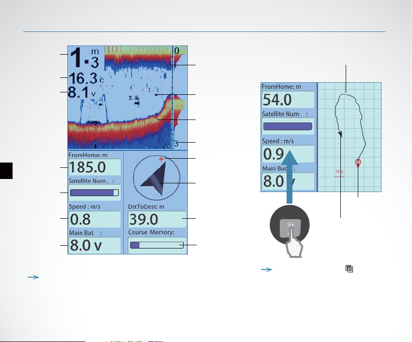
What’s on the display
Depth
readout
Water temp
Voltage of
bait boat
3
Distance
to Home
Satellite
number
Speed
of boat
Voltage of
display
Surface
clutter
Fish symbol
Structure
Depth range
at bottom
Target waypoint
Indicator of
Boat heading
direction
(TF640 only)
Distance to
target
Course
memory
Route of boat
Home Point
Indicator of Boat
heading direction
Note: for TF630, the Compass (indicator of
boat heading direction) is not displayed.
Note: you can use the key to
switch between Compass and Route
display.
Page 5
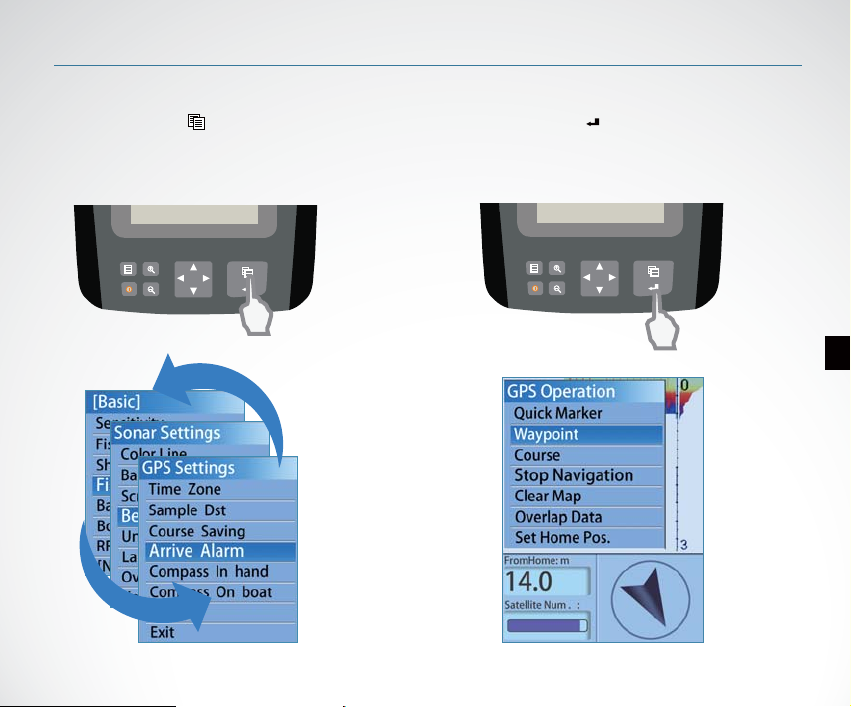
Menu Operation
Switch Menus
you can use the key to
switch between main menus.
Quickly enter into 【GPS operation】
you can use the key to quickly
enter into【GPS Operation】 menu.
4
Page 6
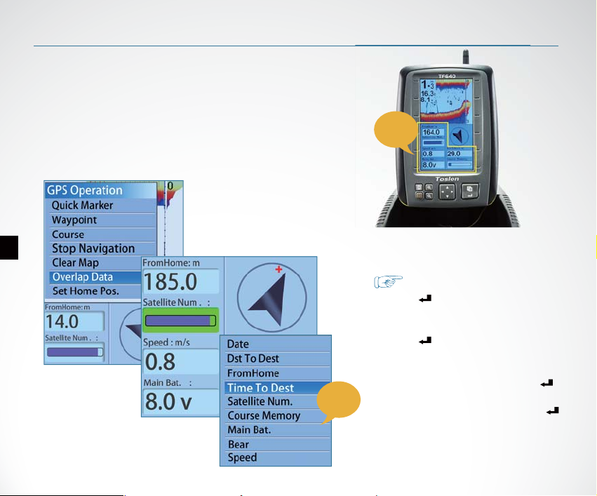
Overlap Data
In the GPS data area of the display, you can
choose to show any of the following options:
FromHome, Distance to Home, Speed of boat,
Time to Board, Satellite number,
Latitude/longitude of boat, Heading, Bear,
Course memory, Time of day, Main battery, etc.
Overlap Data determins which option will be displayed.
5
GPS
option
GPS
data
area
How to set the Overlap Data?
1)Press Key, appears
【GPS Operation】 menu.
2)Use keypad to choose【Overlap Data】
3)Press Key, you will nd one of
option become Green.
4) Use keypad to choose an option which
you hope to change, then press key,
the GPS option menu appears.
5)Choose an GPS option and press
Key , then the selected opition is
successfully changed to new option.
Page 7
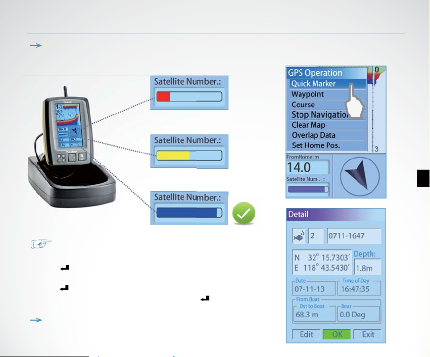
Note: please start using the device only when the Satellite Number bar become
blue, which means the GPS signal is strong enough.
How to creat a waypoint?
When the boat run to a certain position:
1) Press Key, appears 【GPS Operation】menu.
2) Use keypad to choose 【Quick Marker】
Press Key, appears the waypoint detail.
3) Set the options and choose 【OK】, then Press Key .
Then the waypoint was successfully created and saved in waypoint list.
Note: you can set dierent icon, number, name, depth, etc for
each waypoint.
Start Using
6
Page 8
Start Using
7
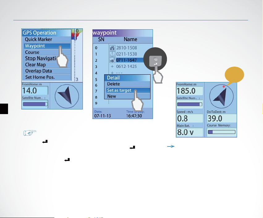
1)Press Key, appears 【GPS Operation】 menu.
2)Use keypad to choose【Waypoint】, then press Key.
3)In the appeared waypoint list, use keypad to choose a
waypoint. Press Key.
4)On the waypoint 【Detail】, choose【Set as Target】
Now, the selected waypoint was successfully set as target waypoint.
How to choose a waypoint as target?
target
waypoint
Note: as soon as a waypoint was
set as target, a red ”+” will appear
on the compass area which represents
the target waypoint.
Page 9
How to know how far
the boat has run away?
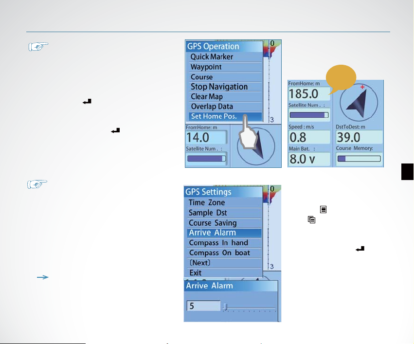
Before you start running the boat,
please set the current position (shore)
of boat as HOME Pos:
1)Press Key, appears 【GPS
Operation】 menu.
2)Use keypad to choose【Set Home
Pos.】, then press Key.
Now, on the screen, the option
【FromHome】will be the distance
the boat has run away.
How to change the radius of
arrive alarm?
The default radius of arrive alarm is
5m, which means the unit will sound
alarm as soon as the boat is 5m far
from the target waypoint.
To acheive a more accurate position,
you can set it to a smaller value, for
example, 2m.
Note: if the radius of arrive alarm is
set too small, for example 1m, the
boat may not be positioned to the
target waypoint under poor GPS
singal.
Start Using
Distance
8
1)Press Key, then repeatlly
press key to switch to【GPS
Settings】 menu.
2)Use keypad to choose【Arrive
Alarm】, then press Key.
3) Use keypad to increase/decrease
the value of【Arrive Alarm】
Page 10
Menu List
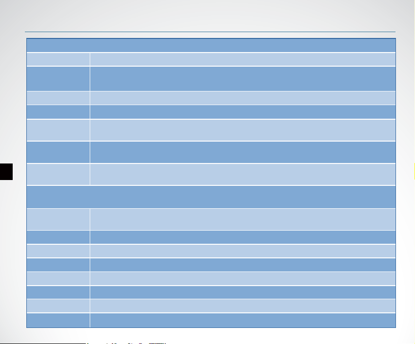
Basic
Sensitivity Controls the level of details shown on the display.
Fish ID. Sens
Shallow Alarm
Fish Alarm Fish Alarm sounds when the shnder detects what it determines to be a sh.
Battery Alarm
Boat VTG.
Alarm
9
RF Channel
Color Line
Backlight adjust the brightness of backlight.
Screen BkGnd Set the display mode of screen (blue, white, black).
Beeper Set if the sonar unit sound a tone or not when a key is pressed.
Units set the units of measure for all depth-related readouts.
Language Select the display language for menus.
Overlap Data Used to select data shown on the sonar page (water depth, temperature, voltage).
Keel Oset Adjust the digital depth readout to indicate depth from the waterline or boats keel.
Adjust the threshold of sh size display. higher setting allows weak returns being displayed
as sh, while a low setting will prevent weak sonar returns being displayed as sh.
Shallow Alarm sounds when the depth becomes equal to or less than the menu setting.
Battery Alarms sounds when the input battery voltage of display is equal to or less than
the menu setting.
Battery Alarms sounds when the input battery voltage of display is equal to or less than
the menu setting.
Set dierent RF channel to allow more than one users operating the device in the same
region without any radio interference.
Sonar Setting
Separates strong sonar echoes from weak sonar echoes. That makes it easier for you to
distinguish sh for structure from the bottom.
Page 11
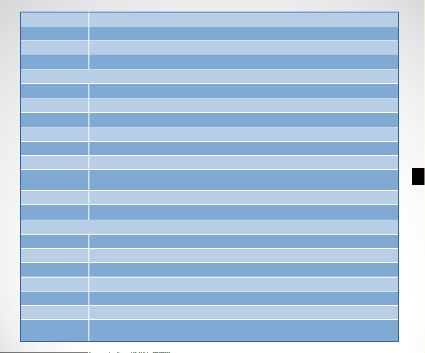
Baud Rate Used to control data transmission with external device.
System Reset Used to restore original factory setting.
Simulator Used to let you practicing using the Fishnder as if you were on the water.
System Info Show system information of device.
GPS Setting
GPS Filter Determines in what satellite condition the device will stop GPS navigation automatically.
Dst. Unit Selects the units of measure for all distance-related readouts.
Spd. Unit Selects the units of speed of boat.
Time Zone
Sample Dst
Course Saving
Arrive Alarm
Compass in hand Used for compass calibration of the display.
Compass on boat
Selects time zone for using in dierent countries.
Set how long the distance per GPS data sampling.
Set the method of course saving when the course memory is full.
Arrive alarms sounds when the distance from boat to target waypoint is equal or less
than the menu setting.
Used for compass calibration of the boat.
GPS Operation
Quick Marker Used to quickly save an waypoint. You can set an icon, name, date, etc for the waypoint.
Waypoint List of waypoints which you have created. These waypoints can be edit or delete.
Course List of route which you can choose to edit or set as target.
Stop Navigation
Clear Map Used to clear the route display on the screen.
Olverlap Data Determines what GPS data will be shown on the display.
Set Home Pos
Used to stop current navigation.
Set the current position of boat as HOME position. This is necessary when you hope to
know how far the boat has run.
10
Page 12
11
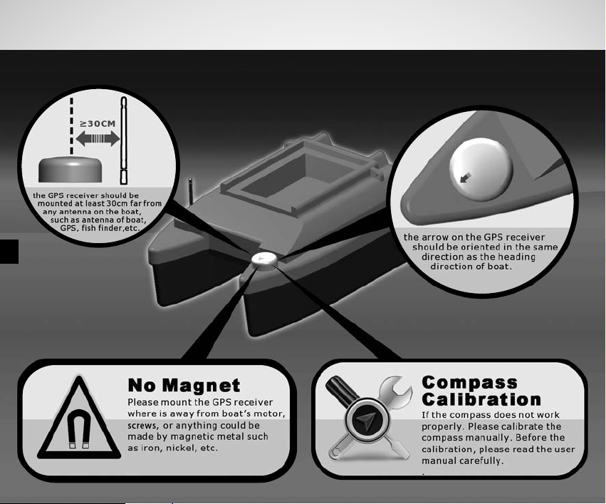
GPS Receiver Mounting
Page 13
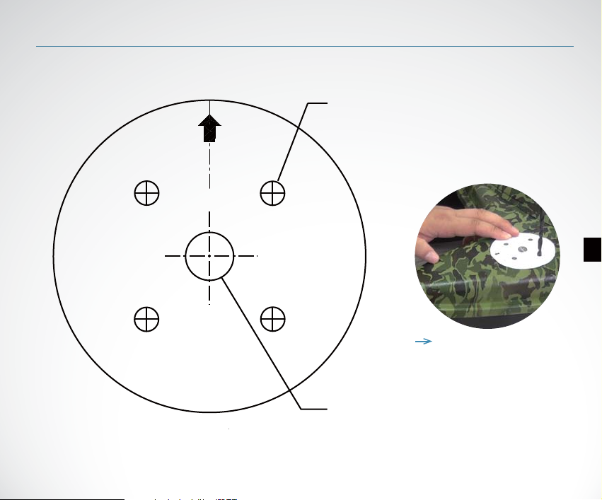
Paper card of GPS Receiver Mounting
Drill size 3/16" (4.75 mm)
Drill four places.
Drill size 1/2"
(12.7mm) if needed.
12
Note: please use the
paper card to guide the
GPS receiver mounting.
Page 14
Page 15

 Loading...