

Page 1
User Guide
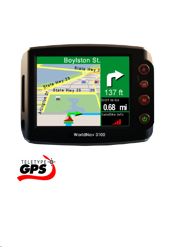
WorldNav 3100
© 2007 TeleType Co.
Page 2

WorldNav 3100
© 2007 TeleType Co.
All rights reserved. No parts of this work may be reproduced
in any form or by any means - graphic, electronic, or
mechanical, including photocopying, recording, taping, or
information storage and retrieval systems - without the
written permission of the publisher.
Products that are referred to in this document may be either
trademarks and/or registered trademarks of the respective
owners. The publisher and the author make no claim to
these trademarks.
While every precaution has been taken in the preparation of
this document, the publisher and the author assume no
responsibility for errors or omissions, or for damages
resulting from the use of information contained in this
document or from the use of programs and source code that
may accompany it. In no event shall the publisher and the
author be liable for any loss of profit or any other
commercial damage caused or alleged to have been
caused directly or indirectly by this document.
Printed: May 2007 in (Boston, MA USA)
Page 3

Table of Contents
Contents
1
Part I
Part II
1
2
3
4
5
6
7
8
9
Introduction
...................................................................... 6Disclaimer 1
...................................................................... 8Welcome 2
...................................................................... 8In the Box 3
...................................................................... 9Your WorldNav 3100 GPS System 4
...................................................................... 10Quick Start Method 5
Getting Started
...................................................................... 16Main Menu Review
...................................................................... 19Navigation Overview
...................................................................... 20Set Home Address
...................................................................... 28Routing to an Intersection
...................................................................... 33Routing Using POIs
...................................................................... 38Finding a My Point
...................................................................... 40Finding or Routing To an Address
...................................................................... 44History
...................................................................... 45Reroute and Clear Route
6
16
10
...................................................................... 46Your GPS Settings
© 2007 TeleType Co.
Page 4

WorldNav 3100
2
Part III
1
2
3
4
Part IV
1
2
3
4
5
6
7
Part V
1
2
Working with My Points
...................................................................... 48Create a My Point
...................................................................... 48Mark My Point at Current Position
...................................................................... 51Editing My Points
...................................................................... 54Deleting a My Point
Navigation Preferences
...................................................................... 57Choosing a System of Units
...................................................................... 59Selecting Route Preferences
...................................................................... 61Selecting Navigation Panel Preferences
...................................................................... 63Setting the POI Preferences
...................................................................... 66Auto Zoom
...................................................................... 68Changing the Voice
...................................................................... 69Changing the Time
Special Features
...................................................................... 722D/3D Views
...................................................................... 74Day/Night Mode
48
57
72
3
4
© 2007 TeleType Co.
...................................................................... 76Trip Information
...................................................................... 77Map Information
Page 5

Contents
3
5
6
7
Part VI
1
2
3
4
5
6
Part VII
1
2
3
4
5
...................................................................... 78Simulating a Route
...................................................................... 80Changing the Adapter Fuse
...................................................................... 81Main Menu
Media Players
...................................................................... 83MP3 Player
...................................................................... 85Movie Player
...................................................................... 86Picture Viewer
...................................................................... 87Media Transfer
...................................................................... 89Map Transfer
...................................................................... 89Extra Media Storage
Hardware Settings
...................................................................... 92Settings Menu
...................................................................... 93Brightness
...................................................................... 95Volume
...................................................................... 96Battery
...................................................................... 98Unit Charging
83
92
6
Part VIII
...................................................................... 98Calibration
Power and Battery Charging
© 2007 TeleType Co.
102
Page 6

WorldNav 3100
4
Part IX
Part X
Index
Device Specifications
Troubleshooting Questions
105
107
111
© 2007 TeleType Co.
Page 7

Part
I
Page 8

WorldNav 3100
6
1 Introduction
1.1 Disclaimer
Use the WorldNav 3100 at your own risk. To reduce
the risk of unsafe operation, please carefully review
and understand this user manual.
It is the user's responsibility to use this product
prudently. This product is intended to be used only as
a navigational aid and must not be used for any
purpose requiring precise measurement of direction,
distance, location, or topography. Statistics provided
such as trip time are best estimates and may not
accurately reflect true conditions.
The Global Positioning System (GPS) is operated by
the United States Government, which is solely
responsible for its accuracy and maintenance. The
system is subject to changes which could affect the
accuracy and performance of all GPS equipment.
For use in vehicles, it is the sole responsibility of the
owner/operator of the TeleType GPS WorldNav 3100
to place and secure the GPS unit so that it will not
interfere with the vehicle operating controls and safety
devices, obstruct the driver's view of driving
conditions, or cause damage or personal injury in the
event of an accident. Do not mount the TeleType GPS
WorldNav 3100 in a place where the driver or
passengers are likely to impact it in an accident or
collision. The mounting hardware supplied by
TeleType Co. is not warranted against collision
© 2007 TeleType Co.
Page 9

Introduction
damage or the consequences thereof.
When used in vehicles, it is the sole responsibility of
the driver of the vehicle to operate the vehicle in a safe
manner, to maintain full surveillance of all driving
conditions at all times, and not become distracted by
the GPS system to the exclusion of safe driving
practices. It is unsafe to operate the controls of the
GPS system while you are driving. Failure by the
driver of a vehicle equipped with a TeleType GPS
system to pay full attention to operation of the vehicle
and road conditions while the vehicle is in motion
could result in an accident or collision with property
damage and personal injury.
IN NO EVENT SHALL TELETYPE CO BE LIABLE
FOR ANY INCIDENTAL, SPECIAL, INDIRECT OR
CONSEQUENTIAL DAMAGES, WHETHER
RESULTING FROM THE USE, MISUSE, OR
INABILITY TO USE THIS PRODUCT OR FROM
DEFECTS IN THE PRODUCT. SOME STATES DO
NOT ALLOW THE EXCLUSION OF INCIDENTAL OR
CONSEQUENTIAL DAMAGES, SO THE ABOVE
LIMITATIONS MAY NOT APPLY TO YOU.
7
© 2007 TeleType Co.
Page 10

WorldNav 3100
8
1.2 Welcome
Congratulations on purchasing the TeleType
WorldNav 3100! This document will provide you with
information on how to use the GPS.
1.3 In the Box
Upon receiving your WorldNav 3100, open the box to
find the following items:
·
WorldNav 3100 Touch Screen GPS
·
Car Power cord
·
USB Sync cable for computer connectivity cord
·
Windshield mount
·
Dash mount adapter
·
Carrying bag
·
User Guide
·
Quick Start Guide
© 2007 TeleType Co.
Page 11
Introduction
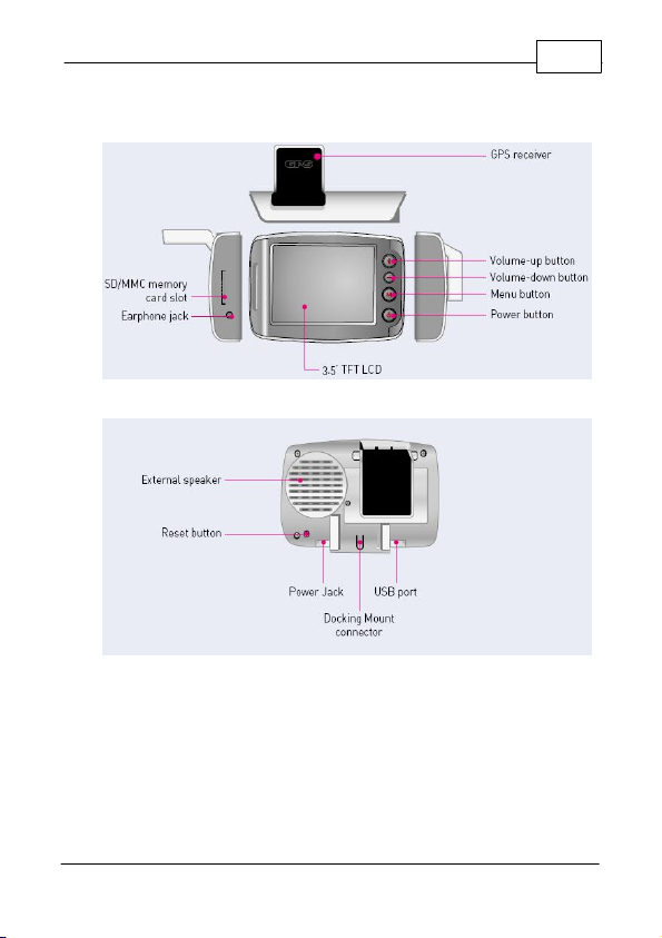
1.4 Your WorldNav 3100 GPS System
Front of your WorldNav 3100
Back of your WorldNav 3100
9
© 2007 TeleType Co.
Page 12
WorldNav 3100
10
1.5 Quick Start Method
1. Plug in the WorldNav 3100 to the 12v car power
lighter in your vehicle. In order to charge the unit
while driving, plug the power cord into the hole on
the bottom right side of the GPS. The GPS will
charge when your car is on. If the WorldNav does
not turn on immediately, press the Reset button
located on the back of the GPS. The reset button
will not erase any of your saved history or points.
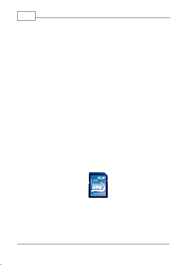
2. Your WorldNav includes a pre-configured Secure
Digital card with maps and points of interest
pre-installed. The card has already been inserted
into the GPS. Removing the card will result in the
GPS becoming non-operational. If in addition you
have purchased an expansion SD Card, to insert
your Secure Digital Card in the side of the GPS,
make sure the metal connection points on the
card match with those visible inside the device. To
remove the card press down on the card, it will
pop up and you can then remove the card from
the slot.
Secure Digital Card
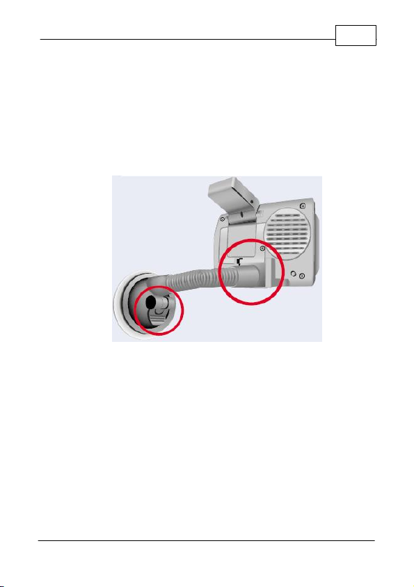
3. Attach your GPS system to the windshield by
putting the suction cup on the window (moisten
cup if necessary) and then by using the flip button
next to the suction cup to achieve suction. Rest
the GPS on the dash to help stabilize it against
© 2007 TeleType Co.
Page 13
Introduction
11
vibration.
4. Flip the built-in receiver up and pointed towards
your windshield. The WorldNav 3100 will
automatically lock into your GPS position; there is
no configuration required. The GPS will know your
direction of travel only once you begin to move.
Mounted WorldNav 3100
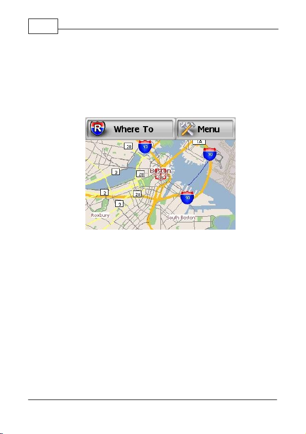
5. From the Main Menu Screen select <Navigation>.
© 2007 TeleType Co.
Page 14
WorldNav 3100
12
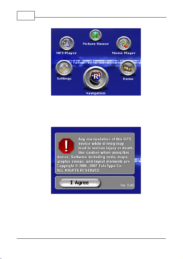
Device Main Menu Screen
6. Press the <I Agree> button to start using the GPS
Device.
Disclaimer Screen
7. If the GPS has not yet locked into position, you
will see <Where To> and <Menu> at the top of the
map screen. The map will display your last
position centered in the "target" [+] area.
© 2007 TeleType Co.
Page 15

Introduction
13
Press <Where To> on the screen to get to the
navigation screen.
Main Mapping Screen
7. Put in your destination by Address, Intersection or
POI (point of interest).
8. The map route from your current location to the
selected location should be displayed.
© 2007 TeleType Co.
Page 16
WorldNav 3100
14
Routing from your last known position
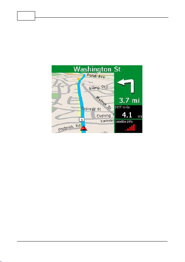
9. If the GPS is locked into position you will hear
"GPS position fixed, ready to navigate." The
<Where To> and <Menu> buttons will disappear.
Sample Routing Screen with Navigation Panel
© 2007 TeleType Co.
Page 17

Part
II
Page 18
WorldNav 3100
Main Menu Screen One
16
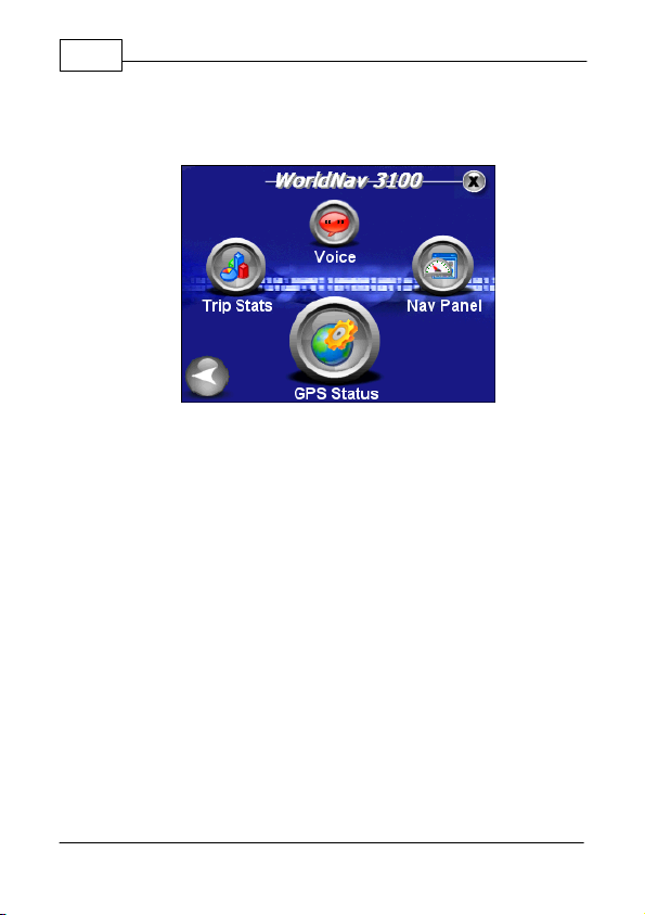
2 Getting Started
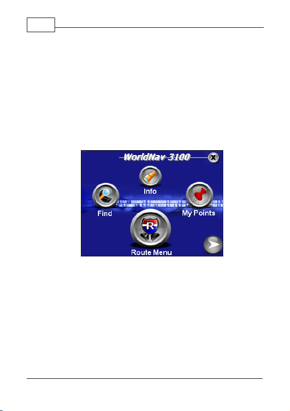
2.1 Main Menu Review
The WorldNav 3100 main menu is accessed anytime
you press the <Menu> button on the touch screen.
There are twelve entries on the Main Menu which are
spread out over 3 screens:
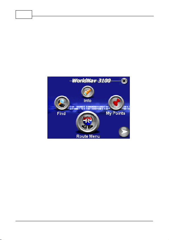
·
Find—lets you into the Find Wizard, situated on two
separate screens, in which you can locate an
Address, Point of Interest (POI), Home,
Intersection, listed My Point or view your Find
History.
·
Info—provides information on your current location.
·
My Points—allows you to mark or manage your My
Points (favorites) and set your Home address.
© 2007 TeleType Co.
Page 19
Getting Started
Main Menu Screen Two
·
Route Menu—lets you into the Route Menu, situated
on two separate screens, in which you can view a
route, create a new route, clear an existing route,
reroute, start a simulation route or select route
settings where you can indicate your preference of
quickest path, shortest path, avoid highways, or
truck route. (Details in Section 4.2)
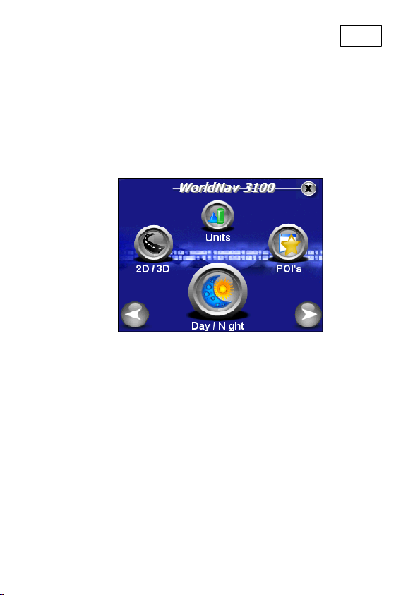
·
2D/3D—to change between two and three
dimensional views. Note: You will not see the
names of most roadways on the 3D view but the
map will look more realistic.
·
Units—lets you choose to navigate in either English
or Metric units.
17
·
POI's—puts you into the POI Display Menu screen
to adjust the Restaurant display, Transport display
and Other POI display.
© 2007 TeleType Co.
Page 20
WorldNav 3100
Main Menu Screen Three
18
·
Day/Night—switches from a night screen to a day
screen and vice versa.
·
Trip Stats—shows you trip statistics such as total
time and distance traveled.
·
Voice—allows user to change the voice of the
WorldNav 3100.
·
Nav Panel—lets you set two identifying panels on
your navigation screen including distance to go,
speed, odometer, heading, satellite info and arrival
time.
·
GPS Status—provides GPS information such as
latitude, longitude, elevation, speed, heading,
date/time and strength of signal.
© 2007 TeleType Co.
Page 21

Getting Started
2.2 Navigation Overview
Now that you are familiar with WorldNav 3100 features
you are ready to begin navigating. When you turn on
your device the GPS will search to acquire satellite
signal. Once you have picked up signal you can
simply press <Where To> and enter a destination to
navigate from your current location. If you are indoors
or unable to pick up satellite signal, you may want to
set your home address manually. You can also create
routes by entering start and end addresses for later
use.
When you are driving, the screen will display your
location in route and you will be given voice
instructions for when and where to turn. Your
destination will be indicated on the map with a
checkered flag. Once you have reached your
destination the route will be cleared and will be ready
to navigate to your next destination.
19
© 2007 TeleType Co.
Page 22
WorldNav 3100
20
2.3 Set Home Address
When you travel away from home it is convenient to
be able to route "Home" easily. You need to set your
home address in the "My Points" Submenu by
pressing <Set Home>. Follow these directions.
Main Mapping Screen
1. Press <Where To> on the main mapping screen,
which will take you to the Find Wizard Menu. You
will be prompted to select one of the following:
POI, Address, Home, Intersection, History or My
Points. Select <Address>. Note: You can also get
to the Find Wizard Menu when you press <Find>
in the main menu.
© 2007 TeleType Co.
Page 23
Getting Started
Find Wizard Menu
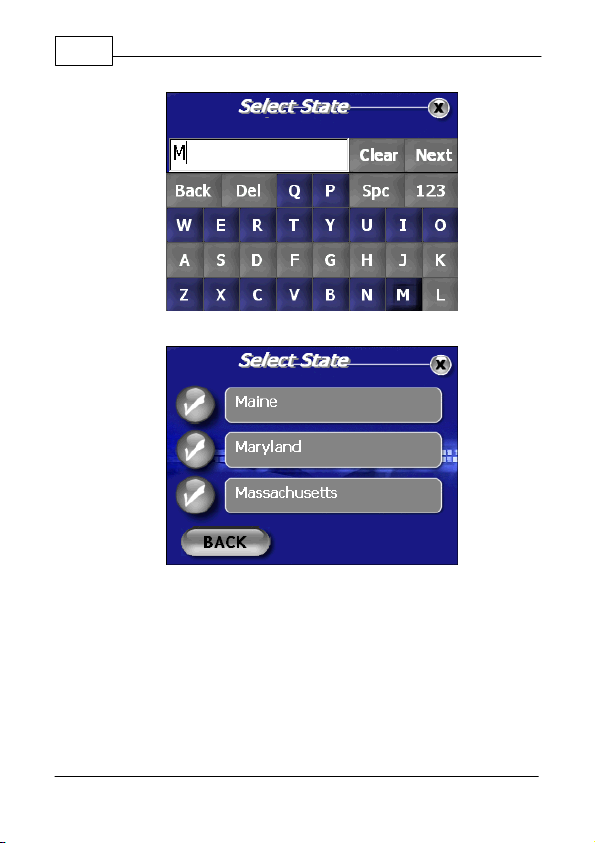
2. You will now be asked to enter the address of
your destination. The WorldNav is equipped with
Smart Search Technology that will automatically
generate possible States, Cities and Street names
based on the first few letters of your entry. The
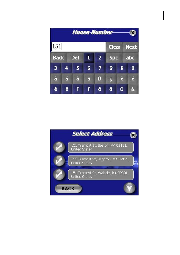
following illustrates the address search for 151
Tremont St, Boston, MA. Note: To select a result,
simply touch the check mark icon next to your
selection.
21
© 2007 TeleType Co.
Page 24
WorldNav 3100
22
Start to Enter State
Select from Possible States
© 2007 TeleType Co.
Page 25

Getting Started
Start to Enter City
Select from Possible Cities
23
© 2007 TeleType Co.
Page 26

WorldNav 3100
24
Start to Enter Street Name
Select from Possible Streets
© 2007 TeleType Co.
Page 27
Getting Started
House Number
3. The WorldNav 3100 will generate search results
based on your entry. Select your destination by
touching the appropriate check mark.
25
Select Address
4. The Start Address will automatically display your
current location. If you would like to modify your
Route at this point, you can touch the magnifying
© 2007 TeleType Co.
Page 28
WorldNav 3100
26
lens icon located to the left of the End Address.
This will take you back to the Find Wizard where
you can enter a new destination. Once your
desired End Address is displayed, press
<Create Route>.
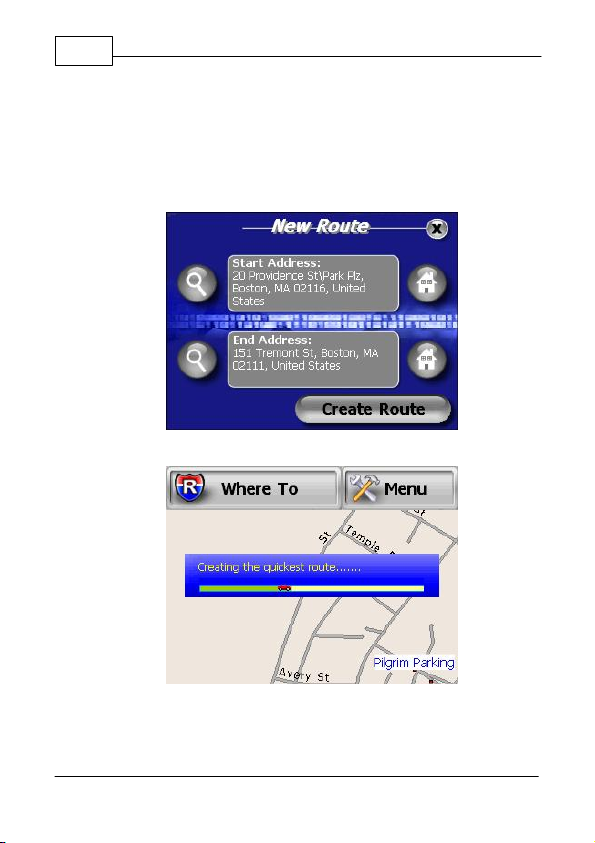
Route Start and End Addresses
Creating Route
5. Drive. The GPS will prompt you at turns and you
© 2007 TeleType Co.
Page 29

Getting Started
can follow the distance remaining or whatever
other parameters you chose in the Navigation
Panel. You can also see the turn by turn
maneuver list by pressing <Route> and then
<View Route>.
View Route Results
27
© 2007 TeleType Co.
Page 30
WorldNav 3100
28
2.4 Routing to an Intersection
This allows you to create a route to a street
intersection if you don't know the exact address of
where you are going. Note: Intersections are for
streets only. The intersection feature cannot be used
for highways or freeway intersections (exits).
1. Press the <Menu> button and then the <Find>
button.
Main Menu and Find
2. This will put you into the Find Wizard where you
can use the right arrow icon to scroll to the
second screen and then press the icon labeled
<Intersection>. Note: In this illustration the
WorldNav will locate the intersection of Beacon
and Park Street.
© 2007 TeleType Co.
Page 31

Getting Started
Find Wizard Menu
3. You will be prompted to enter the first street
beginning with the state, the city and finally the
street name. Press <Next> between adding the
various components of the address until you get to
street name. You make your selection by
touching the check mark next to the street name
in the list of possible streets.
29
Selecting First Intersection Street
© 2007 TeleType Co.
Page 32

WorldNav 3100
30
4. You will now be asked to type the name of the
Second Street you are looking for. After you
enter the Street name press <Find>.
Entering Second Intersection Street
5. Look at the list of possible selections. Pick one
and press the check mark icon to see the
intersection on a map.
© 2007 TeleType Co.
Page 33

Getting Started
Select Correct Intersection
31
6. You can now display the route to this intersection
from your current location simply by pressing
<Create Route>.
Create Route Details
7. You will automatically be taken into driving mode
and guided to your destination. If you would like
to view the route you can select <View Route>
from the Route Menu at any time.
© 2007 TeleType Co.
Page 34

WorldNav 3100
32
View Route
© 2007 TeleType Co.
Page 35

Getting Started
2.5 Routing Using POIs
A POI is a point of interest (or a business) such as a
restaurant or gas station.
1. Select <Menu> and then <Find>.
Find Wizard
2. In the Find Wizard, select <POI> or point of
interest.
3. You can now touch the right and left arrow icons
in order to select your POI search option. You
may choose from <Anywhere> , <By Phone
Number> or <By Nearest>. When your preferred
Route option is displaying in the text field, press
<OK>. Note: The search <By Phone Number>
option will only generate results for the Premium
WorldNav.
33
© 2007 TeleType Co.
Page 36

WorldNav 3100
34
POI Search Option Screen
4. Select <By nearest> for the purposes of this
tutorial. Use this when you don't know the address
or need to find something close by.
5. Select a category such as Automotive, Food &
Drink, Business, Education, etc. If you are
unsure, select the category "All."
© 2007 TeleType Co.
Select POI Category
Page 37

Getting Started
6. Select <Food & Drink> for the purposes of this
tutorial by touching the check mark icon to the left
of the category.
7. You may now browse all Food & Drink
subcategories to search from by touching the
down arrow icon located in the bottom right hand
corner of the screen. You may also select <All>
for to search all types.
Select POI Subcategory
8. You will be prompted to enter a POI name to
search. You may skip the entry of a name to view
all results from this category. Press <Next>.
35
© 2007 TeleType Co.
Page 38

WorldNav 3100
36
Search POI by Name
9. The generated results will be listed according to
the distance they are from your current location.
Distance and direction of each POI is displayed.
Select a POI from an existing result by touching
the corresponding check mark.
Select POI
10. After selecting a POI you will be brought to the
© 2007 TeleType Co.
Page 39

Getting Started
37
Find Result Screen where you can select an
action to take. Using the right and left arrow icons
you will choose <Show>, <Mark> or <Route To>
POI Options
© 2007 TeleType Co.
Page 40

WorldNav 3100
38
2.6 Finding a My Point
If you have created a My Point (to be explained later),
you can find it in the Find Wizard Menu.
1. Press <Menu>, right arrow icon, then
<My Points>.
Find Wizard Menu
2. You are brought to the Manage My Points Screen.
Press the corresponding check mark to proceed.
© 2007 TeleType Co.
Page 41

Getting Started
Manage My Points
3. Press the right and left arrow icons to choose to
either <Show> or <Route To> your My Point.
Press <OK>.
39
Finding a My Point
© 2007 TeleType Co.
Page 42

WorldNav 3100
40
2.7 Finding or Routing To an Address
Press <Menu>, then <Find> to get to the Find Wizard
Menu.
Find Wizard Menu
1. Press the <Address> button. You will be
prompted to enter an address in the usual fashion
beginning with the State. The Smart Search
feature will generate results for each component
of your address entry based on the first few letters
you type.
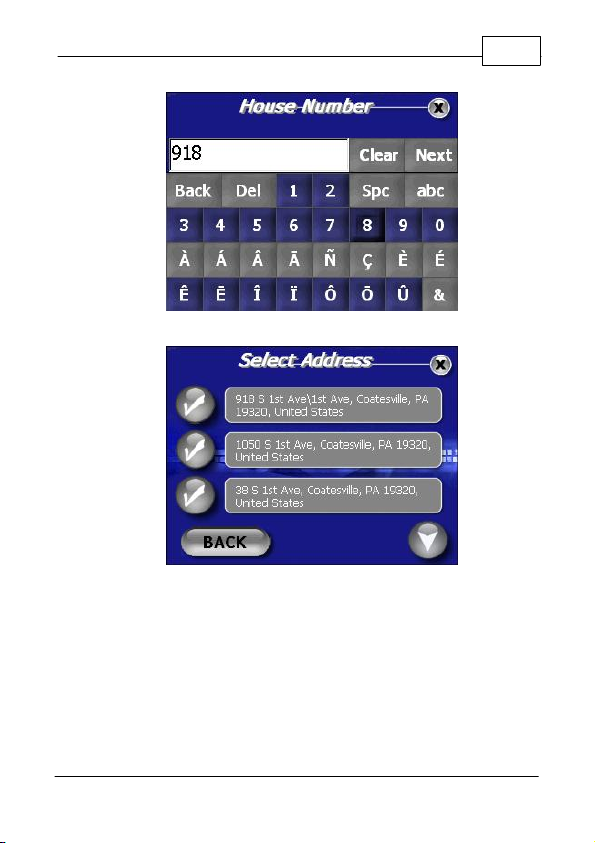
2. For street names that include direction (N, S, SE,
NW, etc...) and/or numbers, (5th Ave, 32nd St,
etc...), you will need to switch between the alpha
and numerical keyboard displays. This can be
done by simply pressing the <123Ñ> and
respective <abc> key once. As an example we
will look up 918 S 1st Ave, Coatesville, PA.
© 2007 TeleType Co.
Page 43

Getting Started
Enter Direction then Press <123Ñ>
Enter Numerical Portion then Press <abc>
41
© 2007 TeleType Co.
Page 44

WorldNav 3100
42
Continue Street Entry
Select Street Name
3. Continue entering the street address by entering
the House Number and then press <Next> and
select the address from the results.
© 2007 TeleType Co.
Page 45
Getting Started
Enter House Number
Select Address from Results
43
© 2007 TeleType Co.
Page 46

WorldNav 3100
44
2.8 History
You may view your Find History by selecting <Find>,
right arrow, and then <History>. From here you may
press a corresponding check mark to show the
address, delete a listing, or view more listings within
the history. Press the recycle bin icon to delete the
entire history.
History of Previous Routes
© 2007 TeleType Co.
Page 47

Getting Started
2.9 Reroute and Clear Route
The <Reroute> function is intended for manual use in
case you prefer to create a new route without waiting
for the GPS to reroute you to a new path. If you are
on a route and have strayed more than 300 feet from
it, press <Menu>, <Route Menu>, right arrow icon, and
finally press <Reroute>. Your position must be locked/
motionless when you activate this function. It will
create a new route based on your current position. If
you want to clear the route you have created, press
<Clear Route>. Note that the GPS will automatically
determine a new route for you to follow if you stray
from the original path.
Select Reroute
45
© 2007 TeleType Co.
Page 48

WorldNav 3100
46
2.10 Your GPS Settings
GPS Information.
menu and then scroll to the third by pressing the right
arrow icon twice. Press <GPS Status>. This will bring
you to the GPS information screen showing your
latitude, longitude, elevation, speed, heading (direction
of travel), date/time, the total number and strength of
satellite signals. Note: See Section 4.7 to adjust time.
Press <Menu> to get to the main
GPS Information Screen
© 2007 TeleType Co.
Page 49

Part
III
Page 50

WorldNav 3100
48
3 Working with My Points
3.1 Create a My Point
A "My Point" is a position marker that can be used to
help create a route or mark a position for future
reference. You can think of the My Points area as a
listing of your favorite places. You can create My
Points regardless of whether the GPS device is active
or inactive. If you are centered on a position that you
would like to create a My Point for, press <Menu> ,
<My Points> and then <Mark Position>. The Mark
Position Screen will come up allowing you to enter a
name, and then you may assign an icon to your new
My Point from the icon gallery. The position will now
be saved as a My Point.
3.2 Mark My Point at Current Position
Press <Menu> and then <My Points>.
© 2007 TeleType Co.
My Points Menu
Page 51

Working with My Points
1. Press <Mark Position> to mark your current
position.
2. Enter the name for your current position and
select an icon to represent the position.
Naming a My Point
49
Selecting a My Point Icon
© 2007 TeleType Co.
Page 52

WorldNav 3100
50
3. Your current position will now be recorded as a
My Point and will appear on the screen as the
icon you selected.
© 2007 TeleType Co.
Page 53

Working with My Points
3.3 Editing My Points
To edit your My Points, press <Menu> and then <My
Points>. This will take you to the My Points menu.
1. Select <Manage>. This will take you to a screen
entitled "Manage My Points". Select the "i" icon
next to the My Point you wish to edit.
Editing your My Points
2. Change the name of the My Point by pressing the
<Name> field and type the new name when
prompted. You can also press the <Icon> field
which will bring you to the icon gallery where you
can assign a new Icon to illustrate your My Point.
51
© 2007 TeleType Co.
Page 54

WorldNav 3100
52
My Point Details
3. When you are finished with any edits to that
particular My Point, press <Back>.
4. To view your edited My Point press the check
mark icon next to it. This will bring you to the Find
Result Screen. With the "Show" option displayed
in the text field, press <OK.>. This will take you to
the map with your My Point centered on the
screen.
© 2007 TeleType Co.
Page 55

Working with My Points
Find Result - Show My Point
My Point on Map
53
© 2007 TeleType Co.
Page 56

WorldNav 3100
54
3.4 Deleting a My Point
1. Press <Menu> , <My Points>, <Manage My
Points> and then press the "i" icon next to the My
Point you wish you delete.
Manage My Points Menu
2. In the My Points Details, press <Delete>. The
selection will now be removed from the list of My
Points.
© 2007 TeleType Co.
Page 57

Working with My Points
My Point Details
55
© 2007 TeleType Co.
Page 58

Part
IV
Page 59

Navigation Preferences
4 Navigation Preferences
4.1 Choosing a System of Units
Specify whether the WorldNav should display
measurements in Metric or English units.
Main Menu - Units
1. Press <Menu>, right arrow icon and then select
<Units>.
2. You can switch between Metric and English units
by pressing the arrow icons. Select one and then
press <OK>.
57
© 2007 TeleType Co.
Page 60

WorldNav 3100
58
System of Units
© 2007 TeleType Co.
Page 61

Navigation Preferences
4.2 Selecting Route Preferences
This allows you to have your routes selected as the
quickest path, the shortest path or a route that avoids
major highways.
1. Press <Menu>, <Route Menu>, right arrow, and
then <Settings>.
Route Menu
2. You will be brought to the Route Settings Screen
where you can select your route preferences.
Enabled Auto-Zoom and Allowing Toll Roads are
indicated by a blue check mark. You can deselect
these options by pressing the icon once. A grey
"x" icon will display when the feature is not
activated.
59
© 2007 TeleType Co.
Page 62

WorldNav 3100
60
Route Settings
You also have the choice of four Route methods. Use
the right and left arrow icons to choose from:
Quickest Path - fastest route regardless of distance
Shortest Path - shortest distance regardless of speed
Avoid Highways - no highways included in route
Truck Route - creates route favoring freeways
3. When the Route Setting screen displays your
desired routing preferences, press <OK> to apply.
© 2007 TeleType Co.
Page 63

Navigation Preferences
4.3 Selecting Navigation Panel Preferences
The name of the next street you must turn onto is
displayed at the top of the Nav Panel. The distance to
your next turn, as well as a directional arrow, are
shown on the upper right section. A checkered flag will
appear in the same section when you reach your
destination. The two other information areas in the
bottom right of the Nav Panel can be customized.
1. Press <Menu>, scroll to the third Menu screen by
using the right arrow icons, and then press <Nav
Panel>. You can choose two values to be display
in the Navigation panel in either the Upper or
Lower Panel.
61
Navigation Panel Preferences
2. In the Navigation Panel Menu, you can scroll the
Upper and the Lower panel to select one of the
following trip information items:
© 2007 TeleType Co.
Page 64

WorldNav 3100
62
·
·
·
·
·
·
·
·
·
Arrival time:
DIST to go:
Heading - Degree:
Estimated time of arrival.
Distance to go.
Directional heading
focused on degrees, such as 270º
Heading - Text:
Directional heading focused
on text, such as West
Odometer:
Satellite Info:
Speed:
Time:
Nav Panel:
Odometer.
GPS signal strength.
Ground speed.
GPS (UTC) time.
Choose from Big Map, Big Panel
or Hide Panel. (Big Map devotes more space
to the map area with a narrower Nav Panel.
Big Panel displays a wider Nav Panel with a
reduced map size. Hide Panel displays no
Navigation stats.)
© 2007 TeleType Co.
Navigation Panel While Driving
Page 65

Navigation Preferences
4.4 Setting the POI Preferences
Choose the types of POIs that you would like to
appear on the map. For the purposes of this tutorial,
let's decide the restaurant types you like.
1. Press <Menu>, right arrow icon, and then
<POI's>.
Select POI's
2. Select <Restaurant>.
63
© 2007 TeleType Co.
Page 66

WorldNav 3100
64
POI Display Menu
3. Scroll the menu using the up and down arrow
icons to view the restaurant options. The choices
listed will appear next to a grey "x" icon. This
indicates that the item is not selected. To select
an item, tap the icon once. It will now appear as a
blue check mark. This indicates that the particular
item is now selected. You may unselect the same
item by tapping the blue check mark icon, which
will then return to the unselected grey state. Once
all of your selections are highlighted, press <OK>.
© 2007 TeleType Co.
Page 67

Navigation Preferences
Restaurant POI Display Preferences
4. You can do the same for Transport display and
General POI display. Only the items you select
will be displayed on the map. For example, if you
unselect all preferences except for the restaurant
category, only your selected restaurant POI's will
be displayed on the map.
65
© 2007 TeleType Co.
Page 68

WorldNav 3100
66
4.5 Auto Zoom
Auto-Zoom will automatically change your map zoom
level depending on your speed. It will zoom in when
you slow down and zoom out when you speed up.
1. Press <Menu>, <Route Menu>, right arrow icon
and then <Settings>.
Route Menu
2. Press the corresponding icon next to <Enable
Auto-Zoom> to turn on/off the Auto Zoom feature.
A blue highlighted check mark icon indicates a
feature is turned on. A grey "x" icon indicates a
feature is turned off.
© 2007 TeleType Co.
Page 69

Navigation Preferences
Auto Zoom
67
© 2007 TeleType Co.
Page 70

WorldNav 3100
68
4.6 Changing the Voice
Select the Voice that guides you during travel. Press
<Menu>, <Route Menu>, use the right arrow icons to
scroll to the third screen and then press <Voice>.
This takes you to the Voice Selection screen where
you select the voice you would like to hear while
navigating. Use the right and left arrow icons to make
your selection. When your preferred voice is
displaying in the text field press <OK>.
Voice Selection Screen
© 2007 TeleType Co.
Page 71

Navigation Preferences
4.7 Changing the Time
The GPS has preset time to U.S. East Coast. To
change that the time your GPS position must be
locked in.
1. Press <Menu>, use the right arrow icons to get to
the third Menu screen and then press <GPS
Status>
Select GPS Status
2. The GPS Information screen will appear. Tap on
the Date/Time field to adjust the time.
69
© 2007 TeleType Co.
Page 72

WorldNav 3100
70
GPS Information Screen
3. Click on the + and – buttons to change the hour
accordingly.
© 2007 TeleType Co.
Page 73

Part
V
Page 74

WorldNav 3100
72
5 Special Features
5.1 2D/3D Views
Your map can be shown in two dimensions where the
streets are clearly marked. This looks like a regular
map. For 3D mode, only the main streets are labeled
but the map more clearly displays what your route
looks while driving.
© 2007 TeleType Co.
Routing in 3D Mode
Page 75

Special Features
Routing in 2D Mode
73
To change from either Routing Mode press <Menu>,
right arrow icon and select "<2D/3D>. From the 2D &
3D View Screen you are able to use the right and left
arrow icons to display your desired setting. Press
<OK> to apply your preference.
Select View Mode
© 2007 TeleType Co.
Page 76

WorldNav 3100
74
5.2 Day/Night Mode
Your map has the ability to have a black background
and blue streets for night vision and a white
background with gray streets for day vision.
Select <Menu>, right arrow icon and then select
<Day/Night>. You can also select <Auto Mode> which
automatically switches from day to night (and vice
versa) based on your current GPS position (lat/long).
When your preferred mode is displayed in the text field
press <OK> to apply the setting.
Select Night Vision
© 2007 TeleType Co.
Page 77

Special Features
Night Mode Map
75
© 2007 TeleType Co.
Page 78

WorldNav 3100
76
5.3 Trip Information
Review trip statistics including speed, distance to go,
estimated time of arrival, time, odometer and trip timer
simultaneously.
Press <Menu>, then use the right arrow icon to get to
the third Menu screen and then press <Trip Stats> to
see the Trip Statistics screen.
Trip Statistics Screen
© 2007 TeleType Co.
Page 79

Special Features
5.4 Map Information
If you press <Menu> and then <Info> the GPS will
display the best estimate of your current location.
Map Information Screen
77
© 2007 TeleType Co.
Page 80

WorldNav 3100
78
5.5 Simulating a Route
You can simulate a previously created route to preview
what it will look like while you are driving.
1. Press <Menu>, <Route Menu>, right arrow icon
and then press <Simulator>.
Select Simulator
2. The simulation will automatically begin.
© 2007 TeleType Co.
Page 81

Special Features
Simulation Mode
3. To end the simulation, simply tap the screen
once. You may resume the simulation mode by
touching <GO> located on the left side of the
screen.
79
Press GO to Resume Simulation
© 2007 TeleType Co.
Page 82

WorldNav 3100
80
5.6 Changing the Adapter Fuse
In the event that the power cable fails to power the
GPS you can replace the fuse. The end of the car
power lighter adapter unscrews, revealing a fuse just
inside the cover. Replace the fuse with a functioning
fuse. Replacement fuses (2 Amps) are readily
available from electronics stores.
Replacing the adapter fuse
© 2007 TeleType Co.
Page 83

Special Features
5.7 Main Menu
Pressing the <Main Menu> hardware button allows
you to exit the navigation program but does not shut
off the GPS altogether. You may want to use this
function to allow access to the Hardware Setup, MP3
Player, Video player, Picture Viewer, or Feature
Demo.
Hardware Menu Button
81
Main Menu
© 2007 TeleType Co.
Page 84

Part
VI
Page 85

Media Players
6 Media Players
6.1 MP3 Player
1. Ready to play music or heard a podcast? Press
the <Main Menu> hardware button, and then
press the <MP3 Player> button.
MP3 Player Button
2. Below is a diagram of all the MP3 player buttons
and their functions.
83
© 2007 TeleType Co.
Page 86

WorldNav 3100
84
MP3 Player
© 2007 TeleType Co.
Page 87

Media Players
6.2 Movie Player
1. Want to see a movie when you're not driving?
Press the <Main Menu> hardware button, and
then press the <Movie Player> button.
Movie Player Button
2. Below is a diagram of all the movie player buttons
and their functions.
85
Movie Player
© 2007 TeleType Co.
Page 88

WorldNav 3100
86
6.3 Picture Viewer
1. Would you like to share your favorite pictures
while traveling? Press the <Main Menu>
hardware button, and then press the <Picture
Viewer> button.
Picture Viewer Button
2. Below is a diagram of all the picture viewer
buttons and their functions.
© 2007 TeleType Co.
Picture Viewer
Page 89

Media Players
6.4 Media Transfer
You can use a SD card reader to install MP3s, videos,
and pictures on your WorldNav 3100. If you don't
have a SD reader you can use the provided USB
cable.
1. Plug the WorldNav 3100 into your computer with
the included USB cable.
2. You will see two folder prompts come up:
87
Auto Play Window
3. Since the drive letters are different on every
computer, select the option <Open folder to view
files using Windows Explorer> in both windows.
© 2007 TeleType Co.
Page 90

WorldNav 3100
88
4. You will need to use the window which has the
following folders:
a. Movie
b. Music
c. Picture
Movie, Music, and Picture folders
5. Close the other window by pressing the <X> in the
upper right corner.
6. Copy the MP3 files you would like from your
computer into the folder ‘Music,’ picture files into
the folder ‘Picture,’ and video files into the folder ‘
Movie.’
© 2007 TeleType Co.
Page 91

Media Players
6.5 Map Transfer
The WorldNav 3100 does not require map transfer.
To be informed of future updates, please register your
WorldNav 3100 at:
www.TeleType.com/Register
6.6 Extra Media Storage
For additional media storage of music, videos, and
pictures, you can choose to use an extra SD card.
Please note that while using the extra SD Storage
card, you will not be able to use the WorldNav 3100
for navigation. You may also copy the entire contents
of the WorldNav SD card to a higher capacity SD card
of your choice that has more available memory. (Do
not use cards labeled as high capacity.)
1. Insert your own SD storage card into your
computer using your own SD card reader.
Secure Digital Card
89
2. Create the following three folders on your SD
storage card:
a. Movie
b. Music
c. Picture
© 2007 TeleType Co.
Page 92

WorldNav 3100
90
Movie, Music, and Picture folders
3. Copy the MP3 files you would like from your
computer into the folder ‘Music,’ picture files into
the folder ‘Picture,’ and video files into the folder ‘
Movie.’
4. Turn off the WorldNav 3100 and remove the SD
card that is inserted on the left side of the GPS.
6. Insert your own SD storage card into the
WorldNav 3100 and reset the device using the
hardware reset button.
7. You can now use the music, video, and picture
viewer to access the media files on your SD
storage card. Remember, while using the extra
SD Storage card, you will not be able to use the
WorldNav 3100 for navigation.
© 2007 TeleType Co.
Page 93

Part
VII
Page 94

WorldNav 3100
92
7 Hardware Settings
7.1 Settings Menu
Here you can change the brightness and volume,
calibrate the screen, and check the battery life.
Hardware Settings Button
© 2007 TeleType Co.
Hardware Settings Menu
Page 95

Hardware Settings
7.2 Brightness
1. Press the <Main Menu> hardware button and then
<Settings>.
Main Menu - Settings
2. Select the <Backlight> tab and adjust the slider to
change screen brightness. A lower Backlight
setting will conserve the battery life.
93
© 2007 TeleType Co.
Page 96

WorldNav 3100
94
Brightness Screen
© 2007 TeleType Co.
Page 97

Hardware Settings
7.3 Volume
1. Press the <Main Menu> hardware button and then
<Settings>.
Main Menu - Settings
2. Select the <Volume> tab and adjust the slider to
increase or decrease the volume.
95
Volume Screen
© 2007 TeleType Co.
Page 98

WorldNav 3100
96
7.4 Battery
1. Press the <Main Menu> hardware button and then
the <Settings> button.
Main Menu - Settings
2. Select the <Battery> tab. The bar shows you how
much battery life is remaining. If the device is
showing 1/4 or less power remaining you should
use the car power cord while driving to recharge
the device.
© 2007 TeleType Co.
Page 99

Hardware Settings
Battery Screen
When the remaining power in the battery is 20~30 %
of its full capacity, a warning window is displayed. In
such a case, immediately recharge the battery.
97
© 2007 TeleType Co.
Page 100

WorldNav 3100
98
7.5 Unit Charging
Your WorldNav GPS has been tested for functionality.
During the shipping process the battery may have
become discharged.
1. Plug the power cord into the bottom of the GPS
in the hole marked DC 12V. Do not plug the cord
into the Audio jack.
2. Press <Reset> button located on the back of
the GPS.
3. As you drive, the battery will charge.
The WorldNav 3100 can be charged with an AC/DC
adapter or the included car power jack. AC/DC
adapters (part # 3020) can be purchased on the
TeleType website. Note: If you buy an A/C adapter be
sure to choose one that offers 12 volts, 1 amp power.
Using lower than 1 amp will not allow the battery to recharge.
7.6 Calibration
1. If you touch the screen and the wrong letter
appears, you may need to calibrate the GPS.
Press the <Main Menu> hardware button and then
<Settings>.
© 2007 TeleType Co.
 Loading...