

Page 1

Camera and Gimbal
This section provides the technical
specifications of the camera and
explains the gimbal’s operation modes.
2015 DJI. All Rights Reserved.
©
30
Page 2
Camera and Gimbal
Camera Prole
The on-board camera uses the 1/2.3 inch CMOS sensor to capture video (up to 30fps with the Phantom 3
Standard) and 12 megapixel stills. You may choose to record the video in either MOV or MP4 format. Available
picture shooting modes include burst, continuous, and time-lapse mode. A live preview of what the camera sees
can be monitored on the WiFi connected mobile device via the DJI Pilot app.
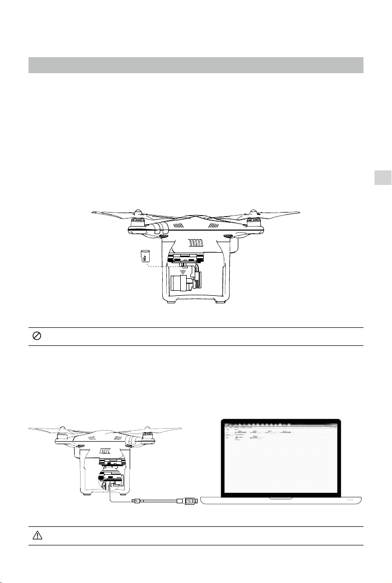
Camera Micro-SD Card Slot
To store your photos and videos, insert the Micro-SD card into the slot, as shown below, before turning on
the Phantom 3 Standard. The Phantom 3 Standard comes with a 16 GB Micro-SD card and supports MicroSD cards up to 64 GB. A UHS-1 Micro-SD card is recommended due to their fast read and write speeds
allowing you to save high-resolution video data.
Gimbal Camera
Do not remove the Micro-SD card from the Phantom 3 Standard when it is turned on.
Camera Data Port
Turn on the Phantom 3 Standard and connect a USB cable to the Camera Data Port to download photos and
videos to your computer.
The aircraft must be turned on before attempting to access the les on the Micro-SD card.
2015 DJI. All Rights Reserved.
©
31
Page 3
Phantom 3 Standard User Manual
Camera Operation
Use the Shutter and Video Recording buttons on the remote controller to shoot the images or videos
through the DJI Pilot app. For more information about how to use these buttons, refer to “Controlling the
Camera Page 24”.
Gimbal
Gimbal Prole
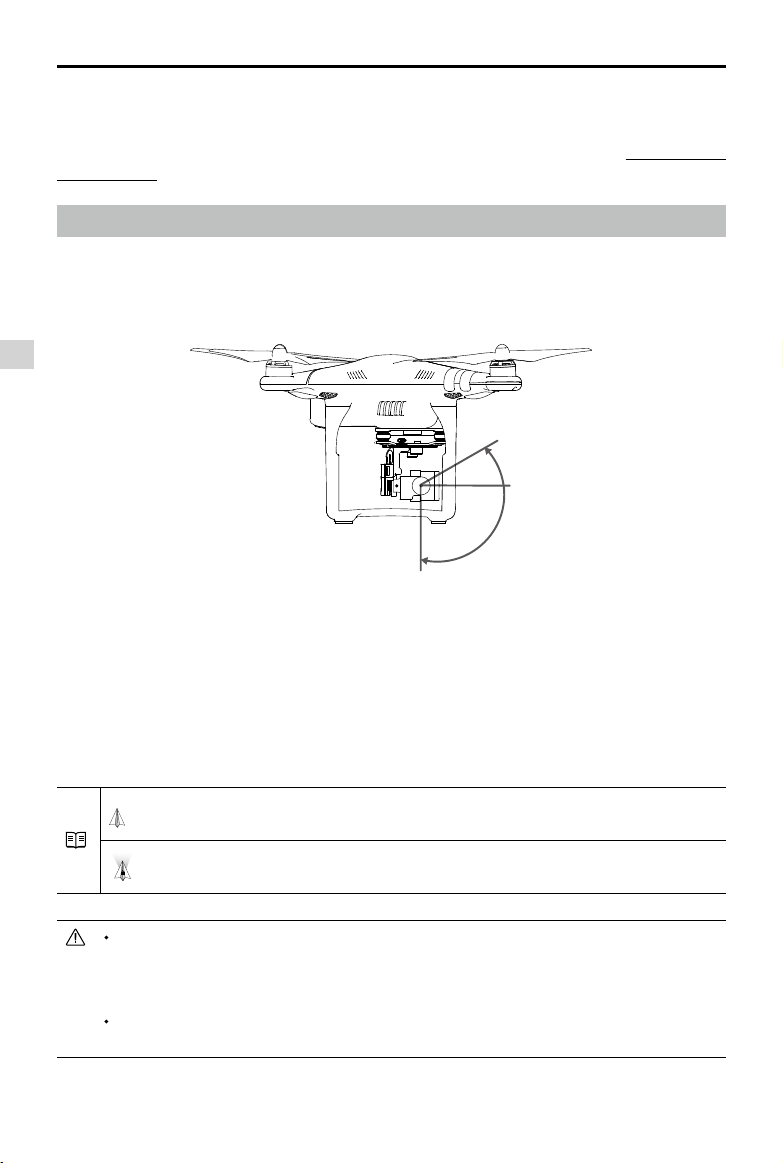
The 3-axis gimbal provides a steady platform for the attached camera, allowing you to capture clear,
stable images and video. The gimbal can tilt the camera within a 120˚ range.
Gimbal Camera
30°
0°
-90°
Use the gimbal dial on the remote controller to control the tilt movement of the camera.
Gimbal Operation Modes
Two gimbal operation modes are available. Switch between the different operation modes on the camera
settings page of the DJI Pilot app. Note that your mobile device must be connected to the remote
controller for changes to take eect. Refer to the table below for details:
Follow Mode
FPV Mode
A gimbal motor error may occur in these situations: (1) the aircraft is placed on uneven ground
or the gimbal’s motion is obstructed (2) the gimbal has been subjected to an excessive
external force, such as a collision. Please take off from flat, open ground and protect the gimbal
at all times.
Flying in heavy fog or clouds may make the gimbal wet, leading to temporary failure. The
gimbal will recover full functionality after it dries.
2015 DJI. All Rights Reserved.
©
32
The angle between gimbal’s orientation and aircraft’s nose remains
constant at all times.
The gimbal will synchronize with the movement of the aircraft to provide a
rst-person perspective ying experience.
Page 4
Phantom 3 Standard User Manual
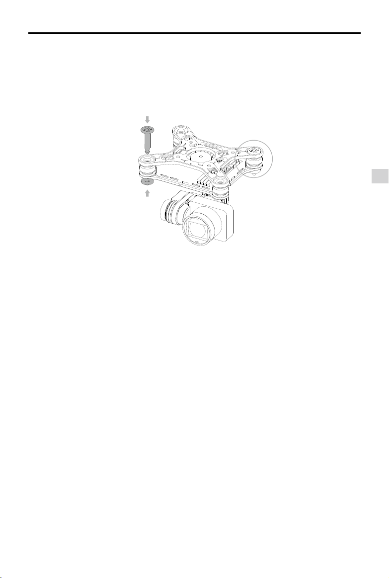
Anti-Drop Kit
The anti-drop kit helps keep the gimbal and camera connected to the aircraft. Two pins have been
mounted prior to shipping. If new or additional pins are required, see the diagram below. Press Part
through the hole of the vibration absorber and into the center hole of Part ②, then lock them together
①
as shown ③. Mounting the anti-drop kit pins diagonally from each other is recommended.
①
③
②
Gimbal Camera
2015 DJI. All Rights Reserved.
©
33
Page 5

DJI Pilot App
This section introduces the four main
functions of the DJI Pilot app.
2015 DJI. All Rights Reserved.
©
34
Page 6

DJI Pilot App
The DJI Pilot app is a mobile application designed specically for the Phantom 3 series. Use this app to control the
gimbal, camera, and other aircraft functions. The app also features Map, Academy, and User Center, which are used
for conguring your aircraft and sharing your photos and videos with others. It is recommended that you use a
tablet for the best experience.
United States
Mountain View
DJI Pilot App
CAMERA
DIRECTOR
STORE DISCOVERY
Camera
The Camera page contains a live HD video feed from the Phantom 3 Standard’s camera. You can also congure
various camera parameters from the Camera page.
[8][7][6][5][4][3][2][1]
MODE
[17]
[16]
[15]
[14]
[13]
P-GPS
H:
CL
M
39
Safe to Fly (GPS)
D:
M
1039
[9]
4821
ISO 100
1/320
EV 0
JPEG
[10]
V.S:
H.S:
M/S
24.2
M/S
M
1.2
8.3
[11][12]
2015 DJI. All Rights Reserved.
©
35
Page 7
Phantom 3 Standard User Manual
[1] Flight Mode
: The text next to this icon indicates the current ight mode.
Tap to configure the MC (Main Controller) Settings. These settings allow you to modify flight limits and
set the gain values.
[2] GPS Signal Strength
: This icon shows the current strength of GPS signals. Green bars indicate adequate GPS
strength.
[3] IOC Settings
CL : This icon displays the IOC setting when the aircraft has entered F-mode. Tap to view the IOC
settings menu and select the desired IOC setting.
[4] System Status
DJI Pilot App
: This icon indicates the current aircraft system status and GPS signal strength.
[5] Battery Level Indicator
: The battery level indicator provides a dynamic display of the battery level. The colored
zones on the battery level indicator represent the power levels needed to carry out dierent functions.
[6] Remote Controller Signal
: This icon shows the strength of remote controller’s signal.
[7] HD Video Link Signal Strength
:
This icon shows the strength of the HD video downlink connection between the aircraft and
the remote controller.
[8] Battery Level
: This icon shows the current battery level.
Tap to view the battery information menu, set the various battery warning thresholds, and view the
battery warning history.
[9] General Settings
: Tap this icon to view the General Settings page. From this page, you can set flight parameters,
reset the camera, enable the quick view feature, adjust the gimbal roll value, and toggle the flight
route display.
[10] Camera Operation Bar
Shutter and Recording Settings
: Tap to enter various camera value settings, including color space for the recording, resolution of
the videos, image size and so on.
Shutter
: Tap this button to take a single photo. Press and hold this button to select single shot, triple shot
or time-lapsed shooting modes.
2015 DJI. All Rights Reserved.
©
36
Page 8
Phantom 3 Standard User Manual
Record
: Tap once to start recording video, then tap again to stop recording. You can also press the
Video Recording Button on the remote controller, which has the same functionality.
Playback
: Tap to enter the playback page. You can preview photos and videos as soon as they are
captured.
Camera Settings
: Tap to set ISO, shutter and auto exposure values of the camera.
[11] Vision Positioning (only available on Phantom 3 Advaned and Professional)
: This icon shows the distance between the surface and the Vision Positioning System’s sensors.
[12] Flight Telemetry
D:
H:
M
39
1039
V.S:
M
8.3
M/S
H.S:
24.2
M/S
M
1.2
The Vision Positioning Status icon is highlighted when the Vision Positioning is in operation.
Flight attitude is indicated by the ight attitude icon.
(1) The red arrow shows which direction the aircraft is facing.
(2) Light blue and dark blue areas indicate pitch.
(3) The angle of the boundary between the light blue and dark blue areas indicates the roll angle.
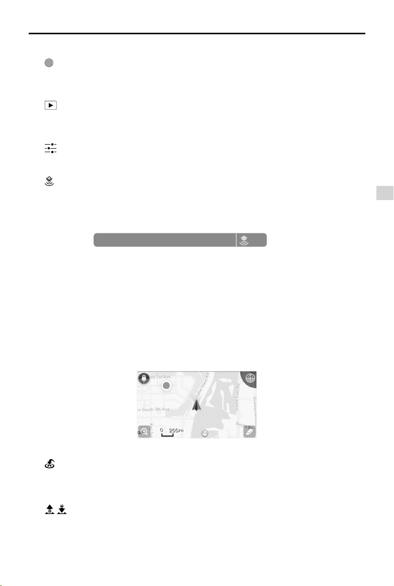
[13] Map
Display the ight path of the current ight. Tap to switch from the Camera GUI to the Map GUI.
[14] Return to Home (RTH)
: Initiate RTH home procedure. Tap to have the aircraft return to the last recorded home point.
DJI Pilot App
[15] Auto Takeo/Landing
/ : Tap to initiate auto takeo or landing.
2015 DJI. All Rights Reserved.
©
37
Page 9

Phantom 3 Standard User Manual
[16] Livestream
: Livestream icon indicates the current video feed is broadcasting live on YouTube. Be sure the
mobile data service is available on the mobile device.
[17] Back
: Tap to return to the main GUI.
Director
Director is an automatic video editor built into the DJI Pilot app. After recording several video clips, simply
tap “Director” from the app’s home screen. You can then select a template and a specified number of
clips, which are automatically combined to create a short lm that can be shared immediately.
Store
DJI Pilot App
Tap “Store” to visit the official DJI Online Store to see the latest information about DJI products and easily
buy new products.
Discovery
Sync pictures and videos to your mobile device, view flight logs, and check your DJI account status in
"Discovery". Use your registered DJI account to login to "Discovery".
2015 DJI. All Rights Reserved.
©
38
Page 10

Flight
This section describes safe flight
practices and ight restrictions.
2015 DJI. All Rights Reserved.
©
39
Page 11

Flight
Once pre-flight preparation is complete, it is recommended that you use the flight simulator in the DJI Pilot
app to hone your flight skills and practice flying safely. Ensure that all flights are carried out in an open
area.
Flight Environment Requirements
1. Do not use the aircraft in severe weather conditions. These include wind speeds exceeding 10 m/s ,
snow, rain and fog.
2. Only fly in open areas. Tall structures and large metal structures may affect the accuracy of the onboard compass and GPS system.
3. Avoid obstacles, crowds, high voltage power lines, trees, and bodies of water.
4. Minimize interference by avoiding areas with high levels of electromagnetism, including base stations
and radio transmission towers.
5. Aircraft and battery performance is subject to environmental factors such as air density and
temperature.Be very careful when flying at altitudes greater than 19, 685 feet (6000 meters) above sea
Flight
level, as the performance of the battery and aircraft may be aected.
6. The Phantom 3 Standard cannot operate within the polar areas.
Flight Limits and No-Fly Zones
All unmanned aerial vehicle (UAV) operators should abide by all regulations set forth by government and
regulatory agencies including the ICAO and the FAA. For safety reasons, flights are limited by default,
which helps users operate this product safely and legally. Flight limitations include height limits, distance
limits, and No-Fly Zones.
When operating in P-mode, height limits, distance limits, and No-Fly Zones function concurrently to
manage flight safety. In A-mode, only height limits are in effect, which by default prevent the aircraft
altitude from exceeding 1640 feet (500 m) .
Maximum ight altitude & Radius Limits
Maximum ight altitude and radius limits may be changed in the DJI Pilot app. Be aware that the maximum ight
altitude cannot exceed 1640 feet (500 meters). In accordance with these settings, your Phantom 3 Standard will y
in a restricted cylinder, as shown below:
Max Radius
Home Point
Height of aircraft
when turned on
2015 DJI. All Rights Reserved.
©
40
Maximum Flight Altitude
Page 12

Phantom 3 Standard User Manual
GPS Signal Strong Blinking Green
Flight Limits DJI Pilot app Aircraft Status Indicator
Maximum Flight
Altitude
Max Radius
GPS Signal Weak Blinking Yellow
Maximum
Flight
Altitude
Max Radius No limits
If you fly out of the limit, you can still control the Phantom 3, but cannot fly it any father. If the
Phantom 3 flies out of the max radius in Ready to Fly (non-GPS) mode, it will fly back within
range automatically.
If the Phantom 3 flies out of the max radius in Ready to Fly (non-GPS) mode, it will fly back
within range automatically.
Aircraft's altitude cannot
exceed the specied value.
Flight distance must be within
the max radius.
Flight Limits DJI Pilot app Aircraft Status Indicator
Height is restricted to 400
feet. (120m) and under.
Warning: Height limit
reached.
Warning: Height
limit reached.
Warning: Distance
limit reached.
None.
Rapid red ashing
when close to the
max radius limit.
None.
Flight
No-Fly Zones
All No-Fly Zones are listed on the DJI official website at http://flysafe.dji.com/no-fly. No-Fly Zones are
divided into Airports and Restricted Areas. Airports include major airports and flying fields where manned
aircraft operate at low altitudes. Restricted Areas include border lines between countries or sensitive
institute. The details of the No-Fly Zones are explained as follow:
Airport
(1) Airport No-Fly Zone are comprised of Take-off Restricted zones and Restricted Altitude Zones. Each
zone features circles of various sizes.
(2) R1 miles (value of the R1 depends on the size and shape of the airport) around the airport is a Take-
o restricted zone, inside of which take o is prevented.
(3) From R1 mile to R1 + 1 mile around the airport the flight altitude is limited to a 15 degree inclination.
Starting at 65 feet (20 meters) from the edge of airport and radiating outward. The flight altitude is
limited to 1640 feet (500 meters) at R1+1 mile
(4) When the aircraft enters within 320 feet (100 meters) of No-Fly Zones, a warning message will appear
on the DJI Pilot app.
2015 DJI. All Rights Reserved.
©
41
Page 13

Phantom 3 Standard User Manual
R1
66 feet
1 mile
R2
1640
feet
66 feet
320 feet
Restricted Area
Flight
(1) Restricted Areas does not have ight altitude restrictions.
(2) R miles around the designated restriction area is a Take-off Restricted area. Aircraft cannot take off
R2
1 mile
R1
within this zone. The value of R varies based on the denition of the restricted areas.
(3) A “warning zone” has been set around the Restricted Area. When the aircraft approaches within 0.6
miles (1 km) of this zone, a warning message will appear on the DJI Pilot app.
100m R
2015 DJI. All Rights Reserved.
©
42
Page 14

GPS Signal Strong Blinking Green
Zone Restriction DJI Pilot App Prompt
Warning: You are in a No-fly
zone. Take o prohibited.
Warning: You are in a no-fly zone.
Automatic landing has begun.
R1: Warning: You are in a
restricted zone. Descending to
safe altitude.
R2: Warning: You are in a
restricted zone. Maximum ight
altitude is restricted to between
20m and 500m. Fly cautiously.
No-y Zone
Restricted-
altitude ight
zone
Motors will not start.
If the aircraft enters the
restricted area in A-mode, but is
switched to P-mode, the aircraft
will automatically descend, land,
and stop its motors.
If the aircraft enters the restricted
area in A-mode, but is switched
to P-mode, it will descend to an
appropriate altitude and hover
15 feet below the altitude limit.
Phantom 3 Standard User Manual
Aircraft
Status
Indicator
Red ashing
Flight
Warning zone
Free zone
Semi-automatic descent: All stick commands are available except the throttle stick command
during the descent and landing process. Motors will stop automatically after landing.
When flying in a safety zone, the aircraft's status indicator will blink red rapidly and continue
for 3 seconds, then switch to indicate current flying status and continue for 5 seconds at which
point it will switch back to blinking red.
For safety reasons, please do not fly close to airports, highways, railway stations, railway lines,
city centers, or other sensitive areas. Fly the aircraft only within your line of sight.
No flight restriction applies, but
there will be a warning .
No restrictions. None. None.
Warning: You are approaching a
restricted zone, Fly cautiously.
2015 DJI. All Rights Reserved.
©
43
Page 15

Phantom 3 Standard User Manual
Preight Checklist
1. Remote controller, Intelligent Flight Battery, and mobile device are fully charged.
2. Propellers are mounted correctly and rmly.
3. Micro-SD card has been inser ted, if necessary.
4. Gimbal is functioning normally.
5. Motors can start and are functioning normally.
6. The DJI Pilot app is successfully connected to the aircraft.
Calibrating the Compass
IMPORTANT: Always calibrate the compass in every new flight location. The compass is very sensitive
to electromagnetic interference, which can produce abnormal compass data and lead to poor flight
performance or ight failure. Regular calibration is required for optimal performance.
Do not calibrate your compass where there is any possibility of strong magnetic interference.
Flight
Sources of potential interference include magnetite, parking structures, and subterranean
metal structures
Do not carry ferromagnetic materials with you during calibration such as keys or cellular
phones.
Do not calibrate in direct proximity to large metal objects.
DO NOT calibrate indoors.
Calibration Procedures
Choose an open area to carry out the following procedures.
1. Ensure that the compass is calibrated. If you did not calibrate the compass as part of your pre-flight
preparations, or if you have moved to a new location since the last calibration, tap the Aircraft Status
Bar in the app and select “Calibrate”, then follow the on-screen instructions.
2. Hold the aircraft horizontally and rotate 360 degrees. The Aircraft Status Indicators will display a solid
green light.
2015 DJI. All Rights Reserved.
©
44
Page 16

Phantom 3 Standard User Manual
3. Hold the aircraft vertically, with nose pointing downward, and rotate it 360 degrees around the center
axis. Recalibrate the compass if the Aircraft Status Indicator glows solid red.
If the Aircraft Status Indicator blinks red and yellow after the calibration procedure, move your
aircraft to a dierent location and try again.
Calibrate the compass before each flight. Launch the DJI Pilot app and follow the on-screen
instructions to calibrate the compass. DO NOT calibrate the compass near metal objects such
as a metal bridge, cars, scaolding.
Flight
When to Recalibrate
1.When compass data is abnormal and the Aircraft Status Indicator is blinking green and yellow.
2.When ying in a new location or in a location that is dierent from the most recent ight.
3.When the mechanical or physical structure of the Phantom 3 Standard has been changed.
4.When severe drifting occurs in ight, i.e. Phantom 3 Standard does not y in straight line.
Auto Takeo and Auto Landing
Auto Takeo
Use auto takeoff only if the Aircraft Status Indicators are blinking green. Follow the steps below to use the
auto takeo feature:
1. Launch the DJI Pilot app, and enter “Camera” page.
2. Ensure the S1 switch on the remote controller is at the upper position.
3. Complete all steps on the pre-ight checklist.
4. Tap“ ”, and conrm that conditions are safe for ight. Slide the icon to conrm and takeo.
5. Aircraft takes o and hovers at (1.5 meters) above ground.
Aircraft Status Indicator blinks rapidly when it is using the Vision Position System for stabilization.
The aircraft will automatically hover below 3 meters. It is recommended to wait until there is
sucient GPS lock before using the Auto Take-o feature.
2015 DJI. All Rights Reserved.
©
45
Page 17

Phantom 3 Standard User Manual
Auto-Landing
Use auto-landing only if the Aircraft Status Indicators are blinking green. Follow the steps below to use the
auto-landing feature:
1. Ensure the aircraft is in P- mode.
2. Check the landing area condition before tapping “ ”, to begin landing. Then follow the on-screen
instructions.
Starting/Stopping the Motors
Starting the Motors
A Combination Stick Command (CSC) is used to start the motors. Push both sticks to the bottom
inner or outer corners to start the motors. Once the motors have started spinning, release both sticks
simultaneously.
Flight
OR
Stopping the Motors
There are two methods to stop the motors.
Method 1: When Phantom 3 Standard has landed, push the throttle down , then conduct the same CSC that was
used to start the motors, as described above . Motors will stop immediately. Release both sticks once motors stop.
Method 2: When the aircraft has landed, push and hold the throttle down. The motors will stop after three
seconds.
OR
Method 1
Do not perform a CSC when the aircraft is in midair, otherwise the motors will suddently stop.
Flight Test
Takeo/Landing Procedures
1. Place the aircraft in an open, at area with the battery level indicators facing towards you.
2. Turn on the remote controller and your mobile device, then turn on the Intelligent Flight Battery.
3. Launch the DJI Pilot app and enter the Camera page.
4. Wait until the Aircraft Indicators blink green. This means the Home Point is recorded and it is now safe
to y. If they ash yellow, the Home Point has not been recorded.
5. Push the throttle up slowly to take o or use Auto Takeo.
6. Shoot photos and videos using the DJI Pilot app.
7. To land, hover over a level surface and gently pull down on the throttle to descend.
8. After landing, execute the CSC command or hold the throttle at its lowest position until the motors stop.
9. Turn o the Intelligent Flight Battery rst, then the Remote Controller.
Method 2
2015 DJI. All Rights Reserved.
©
46
Page 18

Phantom 3 Standard User Manual
When the Aircraft Status Indicators blink yellow rapidly during flight, the aircraft has entered Failsafe
mode.
A low battery level warning is indicated by the Aircraft Status Indicators blinking red slowly or
rapidly during ight.
Watch our video tutorials for more ight information.
Video Suggestions and Tips
1. Go through the full pre-ight checklist before each ight.
2. Select the desired gimbal operation mode in the DJI Pilot app.
3. Only shoot video when ying in P-mode.
4. Always y in good weather and avoid ying in rain or heavy wind.
5. Choose the camera settings that suit your needs. Settings include photo format and exposure compensation.
6. Perform ight tests to establish ight routes and preview scenes.
7. Push the control sticks gently to keep the aircraft’s movement smooth and stable.
Flight
2015 DJI. All Rights Reserved.
©
47
Page 19

FAQ
2015 DJI. All Rights Reserved.
©
48
Page 20

Troubleshooting (FAQ)
Can I remove the camera and attach my own?
No. The cameras that come with both models are permanently attached. Attempting to remove, replace, or
modify the camera may damage the product and will void your warranty.
Can I charge my Remote Controller and Intelligent Flight Battery at the same time?
While the Remote Controller charger and Intelligent Flight Battery charger have been integrated into one
unit for your convenience, it is recommended that you only charge one item at a time. We recommend that
you never charge both items using the same charger at the same time.
What are the buttons on the back of my Remote Controller for?
The two buttons on the back of the Remote Controller can be customized and assigned to function as you
choose through the DJI Pilot app. Refer to the manual for more information.
How far can I y my Phantom 3?
The signal transmission distance will vary depending on environmental conditions, but the Phantom 3
series can reach distances of up to 1.2 miles (2 kilometers) away from the pilot.
What app should I use with my Phantom 3?
The Phantom 3 is compatible with the DJI Pilot app for iOS and Android, which is already used with the DJI
. The app will detect which aircraft is connected and automatically adjust accordingly.
Inspire
Which mobile devices are compatible with the app?
The DJI Pilot app is only compatible with devices running iOS 8.0 or later or Android v4.1.2 or later.
The following devices are recommended:
iOS: iPhone 5s, iPhone 6, iPhone 6 Plus, iPad Air, iPad Air Wi-Fi + Cellular, iPad mini 2, iPad mini 2 Wi-Fi
+ Cellular, iPad Air 2, iPad Air 2 Wi-Fi + Cellular, iPad mini 3, and iPad mini 3 Wi-Fi + Cellular. This app is
optimized for iPhone 5s, iPhone 6, and iPhone 6 Plus
Android: Samsung S5, Note 3, Sony Z3 EXPERIA, Google Nexus 7 II, Google Nexus 9, Mi 3, Nubia Z7 mini
Support for additional Android devices will become available as testing and development continues.
FAQ
2015 DJI. All Rights Reserved.
©
49
Page 21

Phantom 3 Standard User Manual
How do I use the Director automatic video editor?
Director is an automatic video editor built into the DJI Pilot app. After recording several video clips, simply
tap “Director” from the app’s home screen. You can then select a template and a specified number of
clips, which are automatically combined to create a short lm that can be shared immediately.
How do I change the control mode of my Phantom 3?
By default, the Remote Controller is set to Mode 2. This means that the right control stick controls the
movement of the aircraft and the left control stick controls the throttle and orientation of the aircraft. These
controls can be changed to Mode 1 or set to a customized configuration in the DJI Pilot app. This is only
recommended for advanced users.
Can I use a Phantom 2 Remote Controller with the Phantom 3?
No. The Phantom 2 Remote Controller operates on a different frequency. The Phantom 2 Remote Controller
operates at 5.8 GHz and the new Phantom 3 Remote Controller operates at 2.4 GHz.
Can I use a Phantom 2 Intelligent Flight Battery with the Phantom 3?
FAQ
No. The Phantom 3 uses a newly designed Intelligent Flight Battery with greater power. The Phantom 3 has
a 4 cell battery with a capacity of 4480 mAh and a voltage of 15.2 V.
My Phantom 3 does not turn o right away, is something wrong?
This is normal. After you attempt to power off the Intelligent Flight Battery, it may remain on for a few
seconds as any video data is saved to the Micro SD card. This helps prevent your data from being lost or
corrupted.
Do I have to buy the Remote Controller separately?
No, there is no need to buy a separate Remote Controller. Your Phantom 3 comes with a Remote Controller
that is already linked to the aircraft.
Does my Phantom 3 support dual Remote Controllers?
No. The included Remote Controller can be used to control both the aircraft and the gimbal tilt at the same
time.
What does the “P, A, F” switch on the Remote Controller do?
This switch, called the Flight Mode Switch, allows you to toggle dierent ight modes:
P-mode, or Positioning mode, indicates that both GPS and the Vision Positioning System are active and
your Phantom 3 will attempt to stabilize using both.
In A-mode, or Attitude mode, the aircraft does not use GPS or the Vision Positioning System. Only the
barometer is used for stabilization. The aircraft can still return to the Home Point as long as a sufficient GPS
signal is available.
F-mode, or Function mode, activates Intelligent Orientation Control (IOC) functionality. Refer to the IOC
section in the Appendix of the User Manual.
By default, only P-mode may be used. Refer to your user manual for instructions on unlocking the other
modes.
2015 DJI. All Rights Reserved.
©
50
Page 22

Phantom 3 Standard User Manual
What is the Phantom 3 ight time?
Flight times will vary depending on environmental conditions and usage patterns, but the Intelligent Flight
Battery is designed to provide up to 23 minutes of uninterrupted ight time when fully charged.
How can I restore a video le if the power is turned o during recording?
Do not remove the Micro-SD card from the camera. If it has been removed, place it back in the camera.
Turn the Phantom 3 on and wait approximately 30 seconds as the video le is restored.
How can I ensure that my pictures and videos will be synchronized to my iOS album?
You may need to adjust the settings of your mobile device. Open the Settings menu, select the Privacy
tab, select the Photos tab, and then toggle the switch next to the DJI Pilot app icon. If the Pilot app has not
been granted access to your albums, the photos and videos cannot be synchronized.
What should I do to land my Phantom 3 smoothly as possible?
Hover the aircraft over a flat, level surface. Slowly pull the throttle stick down until the aircraft touches the
ground.
Why is the discharge time of the battery not zero, even though I have never used it?
Every battery is tested prior to being packaged and shipped. This affects the discharge time of a new
battery and is the reason that the discharge time is not zero. The battery is safe to use.
Can the mobile device holder be used on the Phantom 2 series Remote Controller?
No, it cannot.
FAQ
How to safely operate the aircraft when encountering compass error?
A compass error may occur when the aircraft is flying close to strong electric magnetic sources (e.g.
power transmission lines). Aircraft Status Indicators blink red and yellow rapidly when a compass error
occurs and the DJI Pilot app will display one of the following messages:
• Compass error, calibration required
This warning message indicates the aircraft is receiving abnormal compass readings. It is recommended
to power o the aircraft and re-calibrate the compass at a dierent location and then resume the ight.
• Compass error, exit P-GPS Mode
This warning message indicates that the aircraft is drifting severely. Bring the aircraft to a higher altitude
to gain enough GPS satellite locks when this warning message is prompted. The flight controller will
automatically adjust the orientation of the aircraft in the midair to mitigate the drifts. The aircraft will switch
back to P-GPS mode when the automatic adjustment is completed.
2015 DJI. All Rights Reserved.
©
51
Page 23

Appendix
2015 DJI. All Rights Reserved.
©
52
Page 24

Appendix
Specications
Aircraft
Weight (Battery &
Propellers Included)
Max. Ascent Speed 5 m/s
Max. Descent Speed 3 m/s
Max. Speed 16 m/s (ATTI mode, no wind)
Max. Flight Altitude 6000 m
Max. Flight Time Approximately 23 minutes
Operating Temperature 0°C to 40°C
GPS Mode GPS
Gimbal
Controllable Range Pitch: - 90° to + 30°
Vision Positioning
Velocity Range < 8 m/s (2 m above ground)
Altitude Range 30 cm-300 cm
Operating Range 30 cm-300 cm
Operating Environment Brightly lit (lux > 15) patterned surfaces
Camera
Sensor Sony EXMOR 1/2.3” Eective pixels:12 M (total pixels: 12.76 M)
Lens FOV 94° 20mm(35mm format equivalent ) f/2.8
ISO Range 100-3200(video) 100-1600(photo)
Electronic Shutter Speed 8s -1/8000s
Image Max. Size 4000 x 3000
Still Photography Modes
Supported SD Card Types
Video Recording Modes HD:1280x720p 24/25/30/48/50/60
Max. Bitrate Of Video
Storage
Supported File Formats
Operating Temperature
Range
1280 g
Single shot
Burst shooting: 3/5/7 frames
Auto Exposure Bracketing (AEB): 3/5
Bracketed frames at 0.7EV Bias
Time-lapse
Micro SD
Max. capacity: 64 GB. Class 10 or UHS-1 rating required
25 Mbps
FAT32/exFAT
Photo: JPEG, DNG
Video: MP4/MOV (MPEG-4 AVC/H.264)
0°C to 40°C
Appendix
2015 DJI. All Rights Reserved.
©
53
Page 25

Phantom 3 Standard User Manual
Remote Controller and WiFi Range Extender
Remote Contoller Frequency 5.725 GHz to 5.825 GHz
Transmitting Distance CE: 400 m, FCC: 800 m
WiFi Range Extender Frequency 2412MHz to 2462MHz
Operating Temperature Range 0°C- 40°C
Battery 2600 mAh Lithium Ion
Mobile Device Holder Smartphones
Working Voltage 120 mA@3.7V
Charger
Voltage 17.4 V
Rated Power 57 W
Intelligent Flight Battery ( PH3-4480 mAh-15.2 V )
Capacity 4480 mAh
Voltage 15.2 V
Appendix
Battery Type LiPo 4S
Energy 68 Wh
Net Weight 365 g
Operating Temperature -10°C- 40°C
Max. Charging Power 100 W
Aircraft Status Indicator Description
Normal
Red, Green and Yellow Flash
Alternatively
Turning on and Self-Diagnostics
Green and Yellow Flash Alternatively Aircraft Warming Up
Green Flashes Slowly Safe to Fly (P-mode with GPS and Vision Positioning)
X2 Green Flashes Twice Safe to Fly (P-mode with Vision Positioning but without GPS)
Yellow Flashes Slowly
Safe to Fly (A-mode but No GPS and Vision Positioning)
Warning
Fast Yellow Flashing Remote Controller Signal Lost
Slow Red Flashing Low Battery Warning
Fast Red Flashing Critical Battery Warning
Red Flashing Alternatively IMU Error
— Solid Red Critical Error
Red and Yellow Flash Alternatively Compass Calibration Required
2015 DJI. All Rights Reserved.
©
54
Page 26

Phantom 3 Standa rd User Manual
Intelligent Orientation Control (IOC)
IOC allows users to lock the control orientation of the aircraft in different modes. There are three working
modes for IOC that can be selected in the DJI Pilot app. IOC only works when the aircraft is in F-mode,
therefore the user must toggle the ight mode switch to activate IOC. Refer to the table below:
The nose direction, at the time that CL is set, will remain the forward direction
Course Lock (CL)
Home Lock (HL)*
Point of Interest (POI)*
*Home Lock and Point of Interest feature are coming soon.
IOC Requirements
IOC is only available under the following conditions:
Modes IOC GPS enabled GPS counts Flight Distance Limits
Course Lock No None None
Home Lock Yes
POI Yes
Using IOC
Toggle the Flight Mode Switch F-mode and follow the instructions prompted on the DJI Pilot app to select
the desired IOC mode.
regardless of how the orientation and position of the aircraft changes. This will
remain xed until you reset it or exit CL mode.
Record a Home Point (HP) and enter HL mode. The forward and backward
controls will move the aircraft farther from and closer to the established Home
Pont, regardless of how the orientation and position of the aircraft changes.
Point of Interest. Record a point of interest (POI). The aircraft can then circle
around the POI and the nose will always points toward the POI.
Aircraft
Aircraft
≥10m
5m~500m
Home Point
Point of Interest
Appendix
2015 DJI. All Rights Reserved.
©
55
Page 27

Phantom 3 Standard User Manual
FCC Compliance
FCC Warning Message
This device complies with part 15 of the FCC Rules. Operation is subject to the following two conditions: (1) This
device may not cause harmful interference, and (2) this device must accept any interference received, including
interference that may cause undesired operation.
Changes or modifications not expressly approved by the party responsible for compliance could void the
user's authority to operate the equipment.
FCC Radiation Exposure Statement:
This equipment complies with FCC radiation exposure limits set forth for an uncontrolled environment.
This W321 should be installed and operated with minimum distance 20cm between the radiator&
your body. This transmitter must not be co-located or operating in conjunction with any other antenna or
transmitter.
Note: This equipment has been tested and found to comply with the limits for a Class B digital device,
pursuant to part 15 of the FCC Rules. These limits are designed to provide reasonable protection against
Appendix
harmful interference in a residential installation. This equipment generates uses and can radiate radio
frequency energy and, if not installed and used in accordance with the instructions, may cause harmful
interference to radio communications. However, there is no guarantee that interference will not occur in
a particular installation. If this equipment does cause harmful interference to radio or television reception,
which can be determined by turning the equipment off and on, the user is encouraged to try to correct
the interference by one or more of the following measures:
—Reorient or relocate the receiving antenna.
—Increase the separation between the equipment and receiver.
—Connect the equipment into an outlet on a circuit dierent from that to which the receiver is connected.
—Consult the dealer or an experienced radio/TV technician for help.
IC RSS warning
This device complies with Industry Canada licence-exempt RSS standard (s). Operation is subject to the
following two conditions: (1) this device may not cause interference, and (2) this device must accept any
interference, including interference that may cause undesired operation of the device.
Le présent areil est conforme aux CNR d'Industrie Canada licables aux areils radio exempts de licence.
L'exploitation est autorisée aux deux conditions suivantes:
(1) l'areil ne doit pas produire de brouillage, et
(2) l'utilisateur de l'areil doit accepter tout brouillage radioélectrique subi, même si le brouillage est
susceptible d'en compromettre le fonctionnement.
2015 DJI. All Rights Reserved.
©
56
Page 28

Phantom 3 Standa rd User Manual
IC Radiation Exposure Statement:
This equipment complies with IC RF radiation exposure limits set forth for an uncontrolled environment.
This transmitter must not be co-located or operating in conjunction with any other antenna or transmitter.
This W321 should be installed and operated with minimum distance 20cm between the radiator&
your body.
Any Changes or modifications not expressly approved by the party responsible for compliance could
void the user’s authority to operate the equipment.
Cet équipement est conforme aux limites d'exposition de rayonnement RSS établies pour un environnement non
contr?lé. Cette M100 devrait être installé et utilisé avec une distance minimale de 20cm entre le radiateur & votre
corps. Cet émetteur ne doit pas être co-implanté ou fonctionner en conjonction avec toute autre antenne ou
transmetteur.
Toute modification non expressément approuvées par la partie responsable de la conformité pourrait annuler
l'autorité de l'utilisateur à utiliser cet appareil.
KCC Warning Message
“해당무선설비는 운용 중 전파혼신 가능성이 있으므로 인명안전과 관련된 서비스는 할 수 없습니다 .”
“해당 무선설비는 운용 중 전파혼신 가능성이 있음”
NCC Warning Message
低功率電波輻射性電機管理辦法
第十二條經型式認證合格之低功率射頻電機,非經許可,公司、商號或使用者均不得擅自變更頻率、加
大功率或變更原設計之特性及功能。
第十四條低功率射頻電機之使用不得影響飛航安全及干擾合法通信;經發現有干擾現象時,應改善至無
干擾時方得繼續使用。前項合法通信,指依電信法規定作業之無線電通信。低功率射頻電機須忍受合法
通信或工業、科學及醫療用電波輻射性電機設備之干擾。
Appendix
2015 DJI. All Rights Reserved.
©
57
Page 29

The content is subject to change.
Download the latest version from
http://www.dji.com/product/phantom-3
If you have any questions about this document, please contact DJI by
sending a message to DocSupport@dji.com.
2015 DJI. All Rights Reserved.
©
 Loading...