

StarGPS GPS-NX01 User Manual
?
Ultra Low Power, High Sensitivity
GPS-NX01 Receiver
User Guide
PixSoft Inc. Tel: +1.204.885.4936 Fax: +1.204.895.4173 E -mail: sales@stargps.ca
1

1. Introduction
1.1 Overview
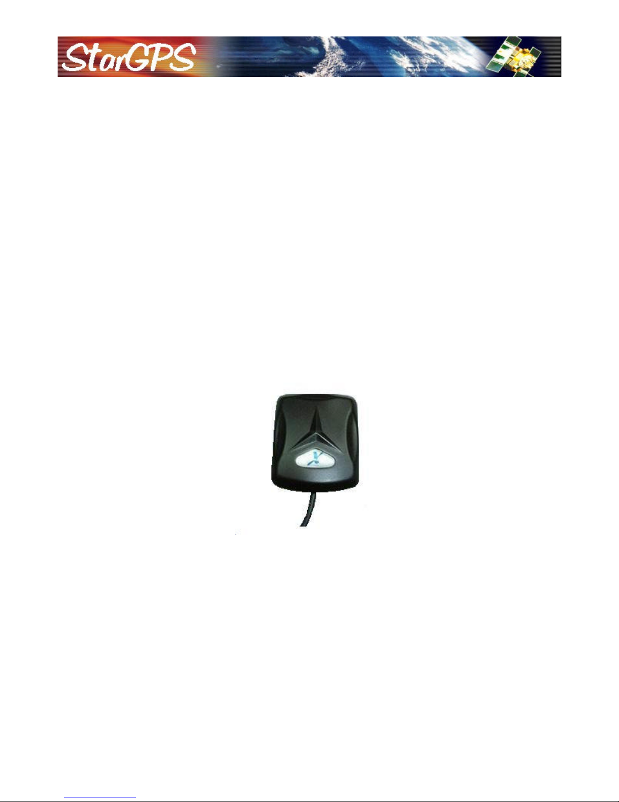
The GPS-NX01 Smart Receiver is an ultra low power GPS receiver based on the proven technology of the
NemeriX NJ1030A chipset. The positioning application meets strict needs such as car navigation, mapping,
surveying, security, agriculture and so on. Only a clear view of the sky and a power supply are needed. With its
ultra low power consumption, the smart receiver tracks up to 16 satellites at a time, re-acquires satellite signals in
1 second (average) and updates position data every second.
The GPS-NX01 can be used as a general purpose GPS receiver with NMEA-0183 output. However, its most
unique feature is the ability to transfer GPS data (time, date, latitude and longitude) to a wide variety of telescopes
that understand the Meade LX200 Command Set or Celestron NexStar Communication Protocol.
1.2 Features
The GPS-NX01 provides a host of features that make it easy to use:
? Fast time-to-first-fix and ultra low power consumption
? High performance NemeriX chipset tracks up to 16 satellites in parallel
? Compact design with integrated antenna/receiver
? Rechargeable Lithium cell sustains internal clock and memory (recharges during normal operation)
? One full duplex serial port with selectable baud rates and NMEA messages
? Supports standard NMEA-0183, Meade LX200 and Celestron NexStar communication protocols
? Automatically detects telescope type (Meade, Celestron or none)
? Switches to standard NMEA output after 30 seconds if no telescope is detected
? LED power indicator blinks to indicate receiver status
? Switches to sleep mode (LED off) 20 minutes after the telescope accepts GPS data
? Automatic cold start with no user initialization required
1.3 Specifications
The GPS-NX01 technical specifications are listed below:
? Size: 47 x 39 x 16 mm (1.9" x 1.5" x 0.6")
? Weight: 70 g (2.5 oz)
? Tracks up to 16 satellites (-152 dBm sensitivity)
? Warm start in 38 seconds (50%), cold start in 45 seconds (50%)
? Position accuracy: 3 meters CEP (50%), 7m (90%)
? Velocity: 0.1 meters/second, without SA
? Time: +/- 100 nanosecond synchronized to GPS time
? Altitude: 18,000 meters (60,000 feet) max
? Velocity: 515 meters / second (1000 knots) max
? Acceleration: 4 G, max
? Interface: RS-232 with 2 m (78") cable (PS/2 Female)
? Baud rate: 9600 (default), 4800, 19200, 38400
? NMEA-0183 Version 2.2 ASCII output: GPGGA, GPGSA, GPGSV, GPRMC, GPVTG, GPGLL, GPZDA
? Meade LX200 Command Set
? Celestron NexStar Communication Protocol (requires firmware version 2.3, 104.0 or 4.0+)
? Power: 3.6 to 5.5 V @ 35 ma (normal) or 16 ma (sleep mode)
? Backup power: 3V rechargeable lithium cell (350 hours)
? Operating temperature: -40 to +85°C (-40 to +185°F)
? Relative humidity: 5% to 90% non-condensing
?
PixSoft Inc. Tel: +1.204.885.4936 Fax: +1.204.895.4173 E -mail: sales@stargps.ca
2
?
2. Hardware Interface
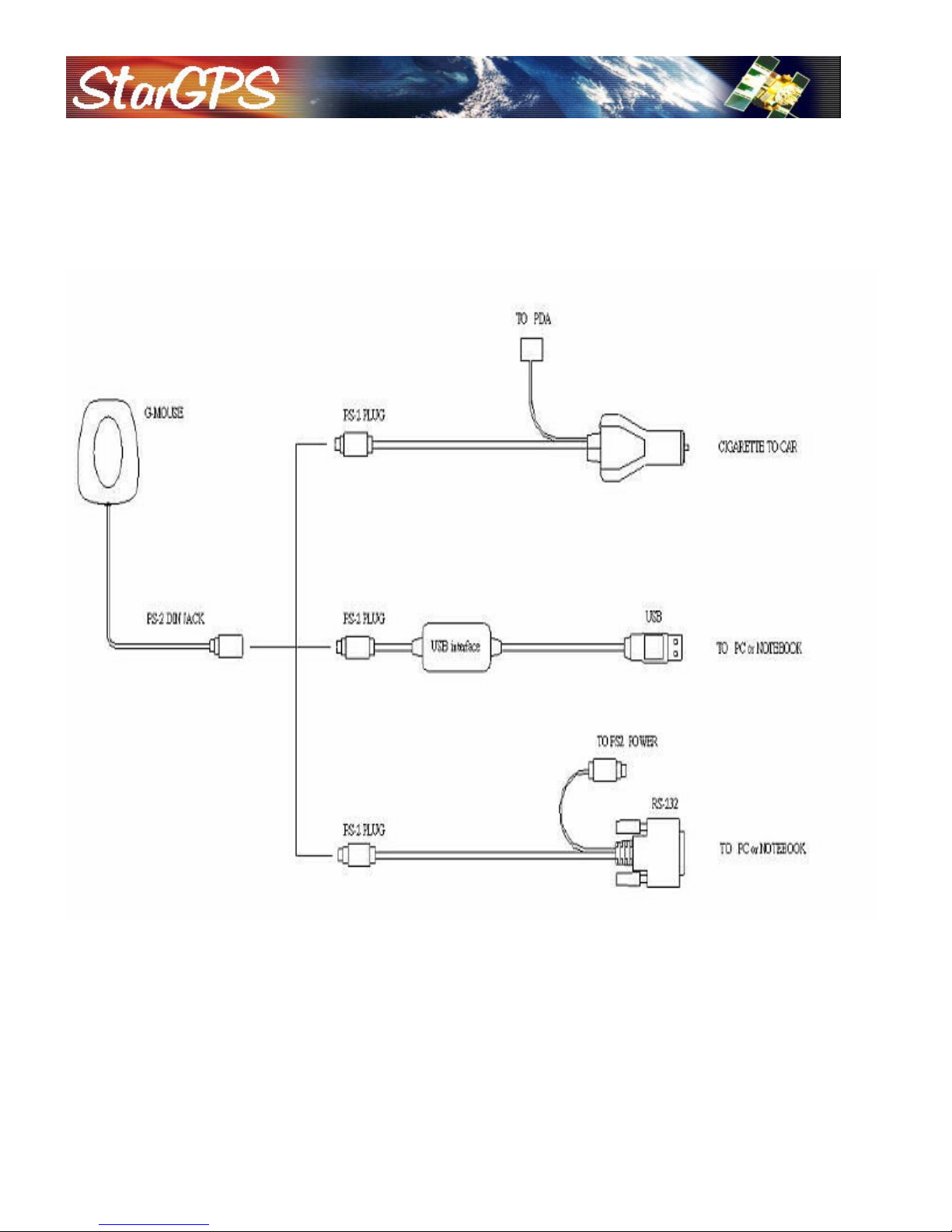
The GPS-NX01 includes a low noise, high gain active antenna in a unique waterproof case. Simply connect the PS/2
female connector to one of the optional accessories and link to either your notebook PC, PDA , telescope or other device.
For telescope adapter cables refer to www.stargps.ca/cables.htm, other cables are listed and described below:
PixSoft Inc. Tel: +1.204.885.4936 Fax: +1.204.895.4173 E -mail: sales@stargps.ca
3
2.1 GPS-NX01 Connector
Pin
1
232)
3
4
232)
Pin
Signal
2
5
6
7
8
9
Pin
1
+5VDC
3
4
5
6
Standard cable: 2 meters with female PS/2 connector.
Pin Assignment of standard PS/2 Din Jack
2.2 GPS-DB9 Cable
Mini Din Female and PS/2 male connector:
Cable Length: To GPS-NX01: 1 meter
RS-232 to PS/2: 45 cm
Mini Din Female connector function definition:
PS/2 composite connector function definition (to PC):
?
2 +5VDC
5 Rx (TTL)
6
Signal
Tx
(RS-
Tx (TTL)
GND
Rx
(RS-
1 N.C.
TX
3
RX
4 N.C.
GND
N.C.
N.C.
N.C.
N.C.
Signal
2
N.C.
N.C.
GND
N.C.
N.C.
PixSoft Inc. Tel: +1.204.885.4936 Fax: +1.204.895.4173 E -mail: sales@stargps.ca
4
?
Pin
1
+5VDC
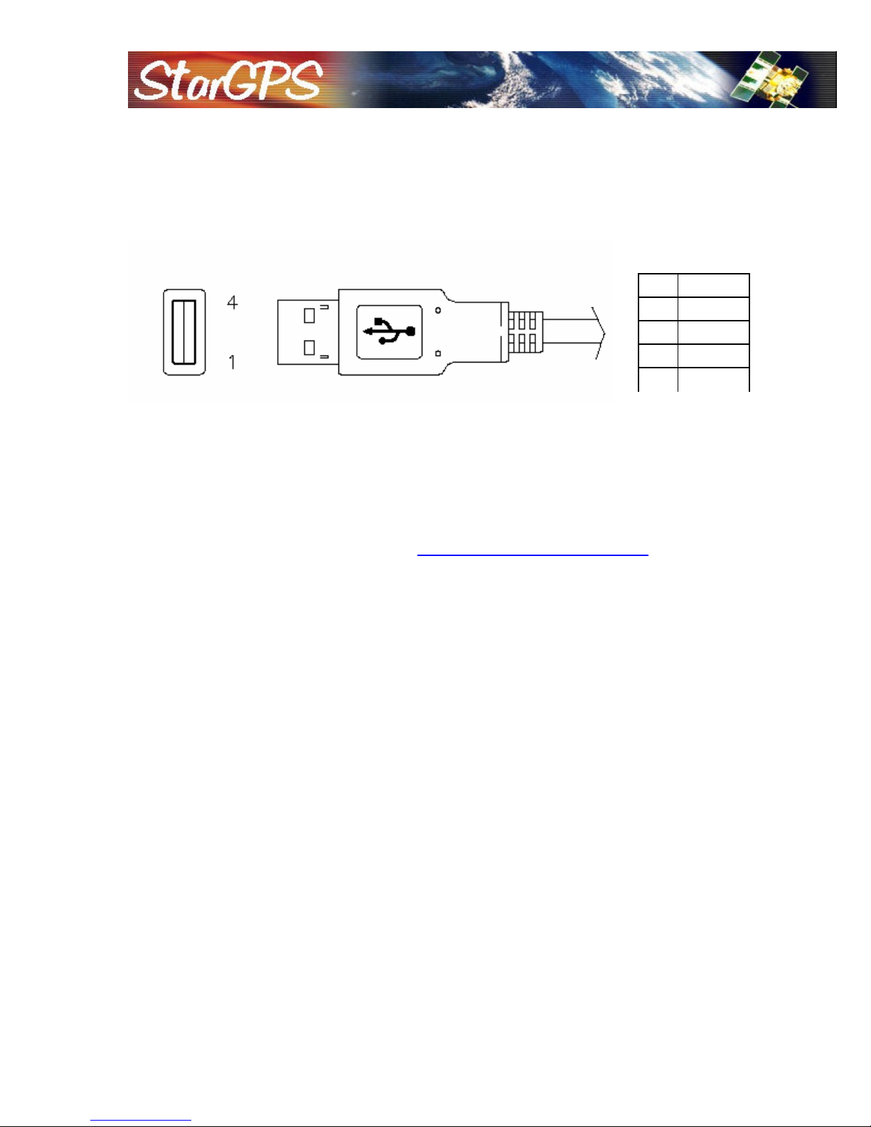
2.3 GPS-USB Cable
PS/2 male connector and A Type USB connector:
Cable Length: USB to PS/2: 50 cm
A Type USB connector function definition:
Signal
2
3
D+
D-
4 GND
3. USB Driver Installation
3.1 System Requirements
Pentium or above and other compatible PC with Windows 98/ME/2000/XP/Vista
3.2 Installation
1. Download and install the USB driver from http://www.stargps.ca/pub/pl2303.zip
2. Plug the USB connector into a USB port on the computer.
3. After the installation is complete, go to <Device Manager> and select <Ports (COM & LPT)> to
verify if a virtual COM port <USB to Serial Port> was created.
4. Connect the GPS-NX01 to the GPS-USB cable.
3.3 Important Notice
Verify the COM port # to start using your own navigating software.
1. Click <Start> menu, select <Settings>, then enter <Control Panel>
2. After entering <Control Panel>, select <System>
3. Select <Device Manager>
4. Find the <Connect Port> and check the Virtual COM Port, which was created by the USB driver.
Please note that the Virtual COM Port number might be different from every computer. Before
using navigating software, please confirm the COM Port numbers created by your computer and
provided by your navigation software. They must be the same Com Port numbers. Otherwise, the
navigating software won’t receive the satellite signal for the un -matched COM Port setting.
4. Warranty
The GPS-NX01 receiver is warranted to be free from defects in material and functions for one year
from the date of purchase. Any failure of this product within this period under normal conditions will
be replac ed at no charge (excluding shipping costs).
PixSoft Inc. Tel: +1.204.885.4936 Fax: +1.204.895.4173 E -mail: sales@stargps.ca
5
?
Recommended minimum specific GNSS data.
Appendix : Software Specification
NMEA Protocol
The software is capable of supporting the following NMEA message formats:
NMEA Message Prefix Format Direction
$GPGGA(1)* GPS fix data. Out
$GPGLL(0) Geographic position Latitude / Longitude. Out
$GPGSA(3)* GNSS DOP and actives satellites Out
$GPGSV(3)* Satellites in view. Out
$GPRMC(1)*
$GPVTG(1)* Velocity and track over ground. Out
$GPZDA(0) Date and time. Out
* The GPS will operate in telescope mode if all NMEA messages are off (this is the default setting).
In this mode the GPS attempts to determine the telescope protocol (Meade or Celestron). If no
telescope is found after 30 seconds the GPS LED will blink rapidly for 5 seconds and then NMEA
output will begin as shown in the above table (0=none, 1= every second, 3=every three seconds).
NMEA Extensions
The software is capable of supporting the following NMEA extensions:
NMEA Message Prefix Format Direction
$PNMRX100 Set serial port parameters. In
$PNMRX101 Navigation initialization In
$PNMRX103 NMEA message rate control In
$PNMRX104 LLA navigation initialization In
$PNMRX106 Set Datum. In
$PNMRX107 NemeriX messages rate control In
$PNMRX108 NMEA message sequence control In
$PNMRX110 Fix Settings In
$PNMRX111 Software Reset In
$PNMRX112 Operating Mode Control In
$PNMRX113 Fix and Extraction control In
$PNMRX300 Almanac data transfer In / Out
$PNMRX301 Ephemeris data transfer. Out
$PNMRX302 Ionospheric correction Out
$PNMRX303 UTC Time Out
$PNMRX304 GPS Constellation Health Status Out
$PNMRX600 SW Version report Out
$PNMRX601 ISP mode In
$PNMRX603 Settings Report Out
Out
PixSoft Inc. Tel: +1.204.885.4936 Fax: +1.204.895.4173 E -mail: sales@stargps.ca
6

?
General NMEA Format
The general NMEA format consists of an ASCII string commencing with a ‘$’ character and
terminating with a <CR><LF> sequence. NMEA standard messages commence with ‘GP’ then a
3-letter message identifier. NemeriX specific messages commence with $PNMRX followed by a 3
digit number. The message header is followed by a comma delimited list of fields optionally
terminated with a checksum consisting of an asterix ‘*’ and a 2 digit hex value representing the
checksum. There is no comma preceding the checksum field. When present, the checksum is
calculated as a bytewise exclusive of the characters between the ‘$’ and ‘*’. As an ASCII
representation, the number of digits in each number will vary depending on the number and
precision, hence the record length will vary. Certain fields may be omitted if they are not used, in
which case the field position is reserved using commas to ensure correct interpretation of
subsequent fields.
The tables below indicate the maximum and minimum widths of the fields to allow for buffer
size allocation.
$GPGGA
This message transfers global positioning system fix data. The $GPGGA message structure is
shown below:
Field Format Min
chars
Message ID $GPGGA 6 6 GGA protocol header.
UTC Time hhmmss.sss 2,2,2.3 2,2,2.3 Fix time to 1ms accuracy.
Latitude float 3,2.4 3,2.4 Degrees * 100 + minutes.
N/S Indicator char 1 1 N=north or S=south
Longitude float 3,2.4 3,2.4 Degree * 100 + minutes.
E/W
indicator
Char 1 1 E=east or W=west
Max
chars
Notes
Position Fix
Indictor
Satellites
Used
HDOP Float 1.1 3.1 Horizontal Dilution of Precision.
MSL Altitude Float 1.1 5.1 Altitude above mean seal level
Units Char 1 1 M Stands for “meters”.
Geoid
Separation
Units Char 1 1 M Stands for “meters”.
Age of
Differential
Corrections
Diff
Reference
Corrections
Checksum *xx (0) 3 3 2 digits.
Message
terminator
PixSoft Inc. Tel: +1.204.885.4936 Fax: +1.204.895.4173 E -mail: sales@stargps.ca
Int 1 1 0: Fix not available or invalid.
1: GPS SPS mode. Fix available.
Int 2 2 Number of satellites used to calculate fix.
Int (0) 1 4 Separation from Geoid, can be blank.
int (0) 1 5 Age in seconds Blank (Null) fields when
DGPS is not used.
int 4 4 0000.
<CR> <LF> 2 2 ASCII 13, ASCII 10.
7

?
<CR> <LF>
$GPGLL
This message transfers Geographic position, Latitude, Longitude, and time. The $GPGLL
message structure is shown below:
Field Format Min chars Max chars Notes
Message ID $GPGLL 6 6 GLL protocol header.
Latitude Float 1,2.1 3,2.4 Degree * 100 + minutes.
N/S Indicator Char 1 1 N=north or S=south.
Longitude Float 1,2.1 3,2.4 Degree * 100 + minutes.
E/W indicator Character 1 1 E=east or W=west.
UTC Time hhmmss.sss 1,2,2.1 2,2,2.3 Fix time to 1ms accuracy.
Status Char 1 1 A Data Valid.
V Data invalid.
Mode Indicator Char 1 1 A Autonomous
Checksum *xx (0) 3 3 2 digits.
Message terminator <CR><LF> 2 2 ASCII 13, ASCII 10.
$GPGSA
This message transfers DOP and active satellites information. The $GPGSA message
structure is shown below:
Field Format Min chars Max
chars
Message ID $GPGSA 6 6 GSA protocol header.
Mode Char 1 1 M Manual, forced to operate in
Mode Int 1 1
Satellites Used Int 2 2 SV on channel 1.
Satellites Used Int 2 2 SV on channel 2.
… . .. .. ..
Satellites Used Int 2 2 SV on channel 12.
PDOP Float 1.1 3.1
HDOP Float 1.1 3.1
VDOP Float 1.1 3.1
Checksum *xx 0 3 2 digits
Message terminator
2 2 ASCII 13, ASCII 10
Notes
selected mode.
A Automatic switching between
modes.
1 Fix not available.
2 2D position fix.
3 3D position fix.
PixSoft Inc. Tel: +1.204.885.4936 Fax: +1.204.895.4173 E -mail: sales@stargps.ca
8

?
$GPGSV
This message transfers information about satellites in view. The $GPGSV message structure
is shown below. Each record contains the information for up to 4 channels, allowing up to 12
satellites in view. In the final record of the sequence the unused channel fields are left blank with
commas to indicate that a field has been omitted.
Field Format Min
chars
Message ID $GPGSV 6 6 GSA protocol header.
Number of
messages
Int 1 1 Number of messages in the message
Max
chars
Notes
sequence from 1 to 3.
Message
number
Satellites in view Int 1 2 Number of satellites currently in view.
Satellite Id Int 2 2 Satellite vehicle 1.
Elevation Int 1 3 Elevation of satellite in degrees.
Azimuth Int 1 3 Azimuth of satellite in degrees.
SNR Int (0) 1 2 Signal to noise ration in dBHz, null if the sv
Satellite Id Int 2 2 Satellite vehicle 2.
Elevation Int 1 3 Elevation of satellite in degrees.
Azimuth Int 1 3 Azimuth of satellite in degrees.
SNR Int (0) 1 2 Signal to noise ration in dBHz, null if the sv
Satellite Id Int 2 2 Satellite vehicle 3.
Elevation Int 1 3 Elevation of satellite in degrees.
Azimuth Int 1 3 Azimuth of satellite in degrees.
SNR Int (0) 1 2 Signal to noise ration in dBHz, null if the sv
Satellite Id Int 2 2 Satellite vehicle 4.
Elevation Int 1 3 Elevation of satellite in degrees.
Azimuth Int 1 3 Azimuth of satellite in degrees.
SNR Int (0) 1 2 Signal to noise ration in dBHz, null if the sv
Int 1 1 Sequence number of this message in
current sequence, form 1 to 3.
is not in tracking.
is not in tracking.
is not in tracking.
is not in tracking.
Checksum *xx (0) 3 3 2 digits.
Message
terminator
PixSoft Inc. Tel: +1.204.885.4936 Fax: +1.204.895.4173 E -mail: sales@stargps.ca
<CR>
<LF>
2 2 ASCII 13, ASCII 10.
9
 Loading...