

Page 1

2005 Pontiac Grand Prix Navigation Manual M
Overview
Overview
Features and Controls
Features and Controls
........................................................ 1-1
.................................................. 1-2
..................................... 2-1
................................ 2-2
Navigation Audio System
Navigation Audio System
Voice Recognition
Voice Recognition
................................................................ 1
Index
........................................... 4-1
................................ 3-1
............................ 3-2
...................................... 4-2
Page 2

GENERAL MOTORS, GM, the GM Emblem, PONTIAC,
the PONTIAC Emblem, and the name GRAND PRIX
are registered trademarks of General Motors
Corporation.
The information in this manual supplements the owner
manual. This manual includes the latest information
available at the time it was printed. We reserve the
right to make changes in the product after that
time without notice.
Keep this manual with the owner manual in your
vehicle, so it will be there if it is needed while you are
on the road. If the vehicle is sold, leave this manual
and the owner manual with the vehicle.
Changes or modifications not expressly approved by
the party responsible for compliance could void
the user’s authority to operate the equipment.
This device complies with Part 15 of the FCC Rules.
Operation is subject to the following two conditions:
(1) this device may not cause harmful interference,
(2) this device must accept any interference received,
including interference that may cause undesired
operation.
This device complies with RSS-210 of Industry Canada.
Operation is subject to the following two conditions:
(1) this device may not cause interference, (2) this
device must accept any interference, including
interference that may cause undesired operation of
the device.
Litho in U.S.A.
Part No. 10382568 A First Edition
ii
©
2004 General Motors Corporation. All Rights Reserved.
Page 3

Section 1 Overview
Overview .........................................................1-2
Navigation System Overview ............................1-2
Getting Started ...............................................1-3
1-1
Page 4
Overview
Navigation System Overview
1-2
Page 5

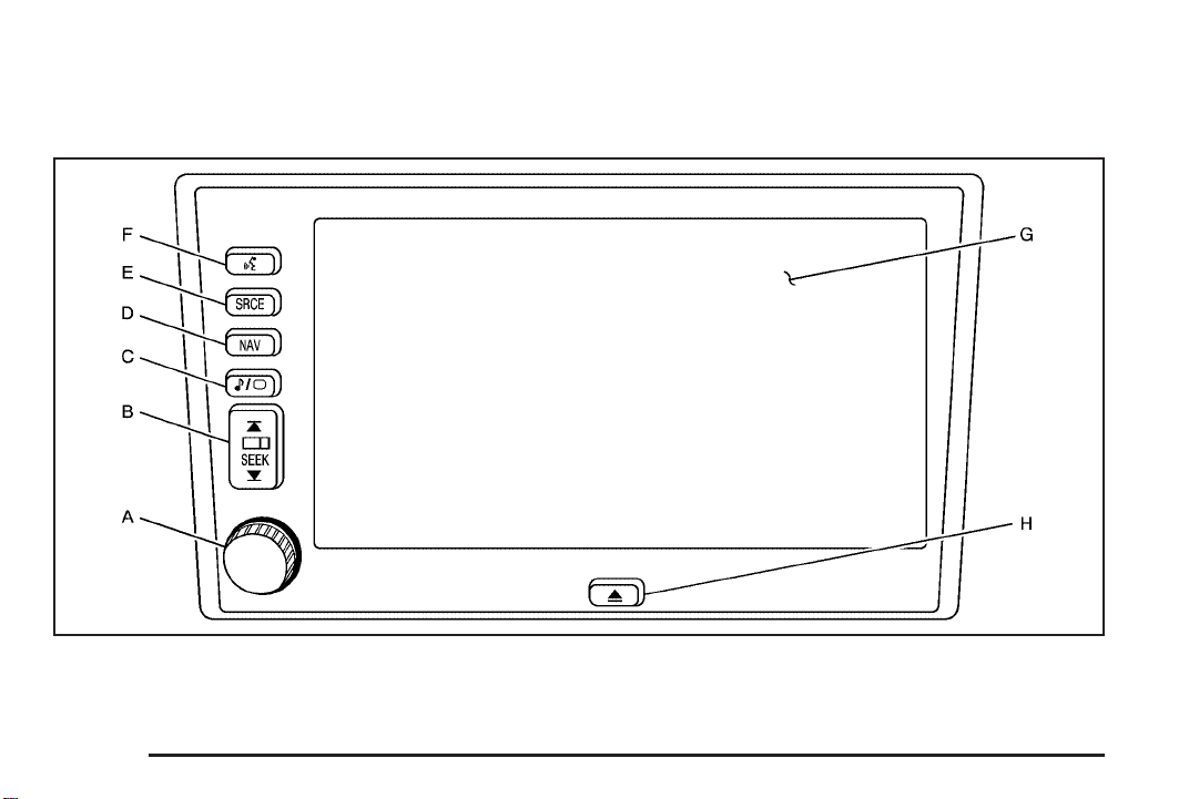
A. Power Volume Knob. See “Hard Keys” under
Using the Navigation System on page 2-2 for
more information.
B. SEEK Key. See “Hard Keys” under Using the
Navigation System on page 2-2 for more information.
C.
e / z Audio/Screen Adjust Key. See “Hard
Keys” under Using the Navigation System on
page 2-2 for more information.
D. NAV (Navigation) Key. See “Hard Keys” under
Using the Navigation System on page 2-2 for
more information.
E. SRCE (Source) Key. See “Hard Keys” under
Using the Navigation System on page 2-2 for
more information.
F.
g (Voice Recognition) Key. See “Hard Keys”
under Using the Navigation System on page 2-2
for more information.
G. Navigation System Screen
H.
X (Open/Close Faceplate) Key. See “Hard Keys”
under Using the Navigation System on page 2-2
for more information.
Getting Started
Before you begin to operate the navigation system,
read this manual thoroughly to become familiar with it
and to understand how the system works.
The navigation system allows you to do the following:
• Plan a route with provided turn-by-turn route
and map guidance with voice prompts.
• Select a destination using various methods
and choices.
• Receive broadcast announcements on traffic
and emergency alert communications.
The information in the system may not always be
complete. Road conditions such as prohibited turns,
detours, and construction zones, change frequently.
It is important to consider whether you can follow
the directions given by the system for the current
conditions.
1-3
Page 6
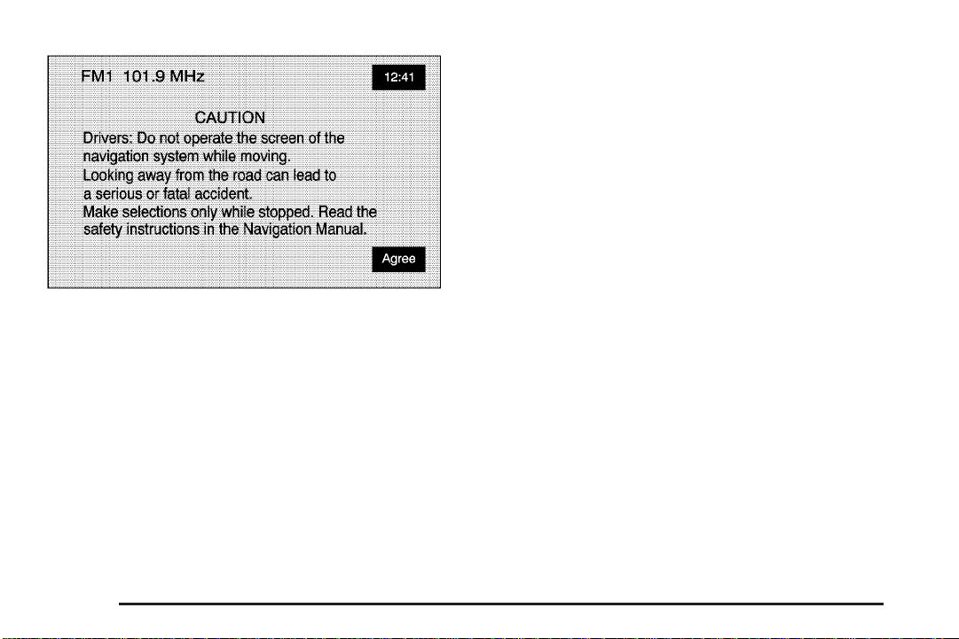
Each time you enter the navigation system, you will see
this screen. You can touch Agree to proceed into the
system. For more information on changing the language,
see “Driver Information Center (DIC)” in your vehicle’s
owner manual.
When getting started you may set the navigation system
to your preference using various options. To do so,
reference the following topics:
• To adjust screen appearance, see “Screen
Appearance” under Navigation Set Up on
page 2-32.
• To adjust the clock and other time options, see
“Clock” under Navigation Set Up on page 2-32.
• To plan a route, see Enter Destination on page 2-5.
• To adjust the volume of voice guidance prompts,
see Navigation Set Up on page 2-32.
1-4
Page 7

Section 2 Features and Controls
Features and Controls ......................................2-2
Using the Navigation System ...........................2-2
Nav. (Navigation) Menu ...................................2-5
Enter Destination ............................................2-5
Stored Locations ...........................................2-22
Navigation Set Up .........................................2-32
Route Options ..............................................2-36
Maps ..........................................................2-42
Symbols ......................................................2-44
Global Positioning System (GPS) ....................2-48
Vehicle Positioning ........................................2-48
Problems with Route Guidance .......................2-49
If the System Needs Service ..........................2-50
Ordering Map DVDs ......................................2-50
Database Coverage Explanations ....................2-50
2-1
Page 8

Features and Controls
Using the Navigation System
This section presents basic information you will need to
know to operate the navigation system.
Use the hardkeys located on the navigation system
along with the available touch screen buttons on the
navigation screen to operate the system. See Navigation
System Overview on page 1-2 for more information.
Once the vehicle is moving, various functions will be
disabled to reduce driver distractions.
Hard Keys
The following hard keys are located on the navigation
system:
Z (Open/Close Faceplate): Press this key located
at the bottom of the Navigation Screen to open or close
the faceplate.
Z B (Eject): Press the CD eject key next to the
CD loading slot to eject CDs. See CD Player on
page 3-14 for more information.
Z DVDB (Eject): Press the DVD eject key next to
the DVD loading slot to eject the map DVD. See CD
Player on page 3-14 for more information.
Power/Volume Knob: Press the power/volume knob
to turn the audio and navigation systems on and
off. Turn the knob to increase or decrease the volume
to the audio system.
g (Voice Recognition): Push the voice recognition
hard key to activate the voice recognition system.
See Voice Recognition on page 4-2 for more
information.
NAV (Navigation): Press the NAV key to access the
map screen. If you press this while a map screen
is displayed and you are in route guidance, the system
will repeat the last voice command.
SRCE (Source): Press the SRCE key to access the
audio source screen. See Navigation Audio System on
page 3-2.
e/ z (Audio/Screen Adjust): Press the
audio/screen adjust key to access the Audio Adjust and
Screen Adjust screens. See Navigation Audio System
on page 3-2.
y©¨z (Seek/Tune): Press the seek/tune arrows
to go to the next or previous radio station and stay
there, or to tune in a station. See Navigation Audio
System on page 3-2.
2-2
Page 9
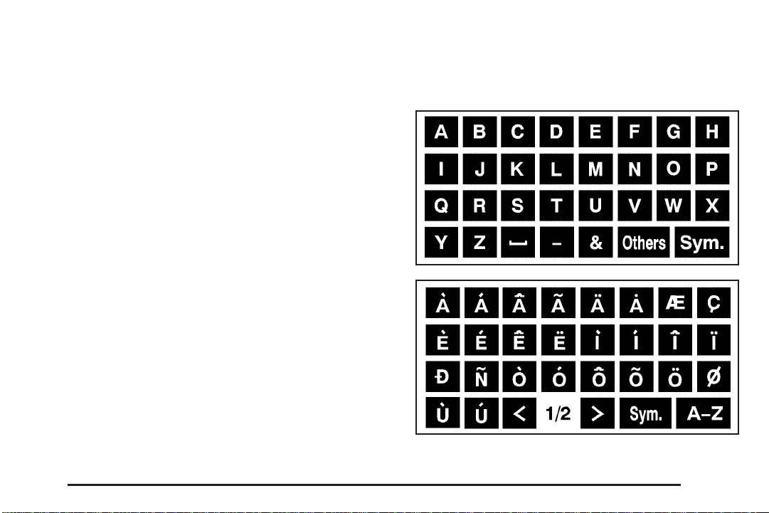
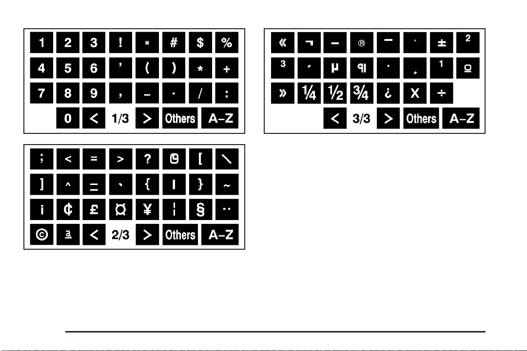
Alpha-Numeric Keypad
Letters of the alphabet, symbols, punctuation, and
numbers, when available to you, will be displayed on
the navigation screen as an alpha or numeric keypad.
The alpha keypad will be displayed when the system
needs you to input a city or street name. You can also
touch the symbol screen button (Sym.) at the bottom
of the alpha keypad to access the numeric keypad when
inputting a house address, punctuation mark, or other
character. Touch A - Z to return to the alpha keypad.
All characters are touch-sensitive screen buttons. Touch
a character to select it.
U: Select the space symbol to enter a space
between characters or the words of a name.
V: Select the backspace symbol if you have selected
an incorrect character.
To make your name selections easier, the system will
only allow you to select a character which can follow the
last one entered. For example, if you enter Z, you
would not be allowed to follow it with T. The system will
highlight the available characters and darken the
unavailable characters.
If you are unsuccessful when inputting a name, it may
need to be selected differently. It is also possible that the
map DVD database may not contain that information
or the correct search area has not been selected.
See Database Coverage Explanations on page 2-50 for
more information.
The following screens are some of the different alpha
keypads you will have access to:
2-3
Page 10
2-4
Touch-Sensitive Buttons
Touch-sensitive buttons, or screen buttons, are located
on the screen. When you have successfully selected
a screen button, a beep will sound. These buttons will be
highlighted when a feature is available and dim when
they are unavailable. There are also some toggle screen
buttons that will be light color when active and dark
color when inactive.
Page 11
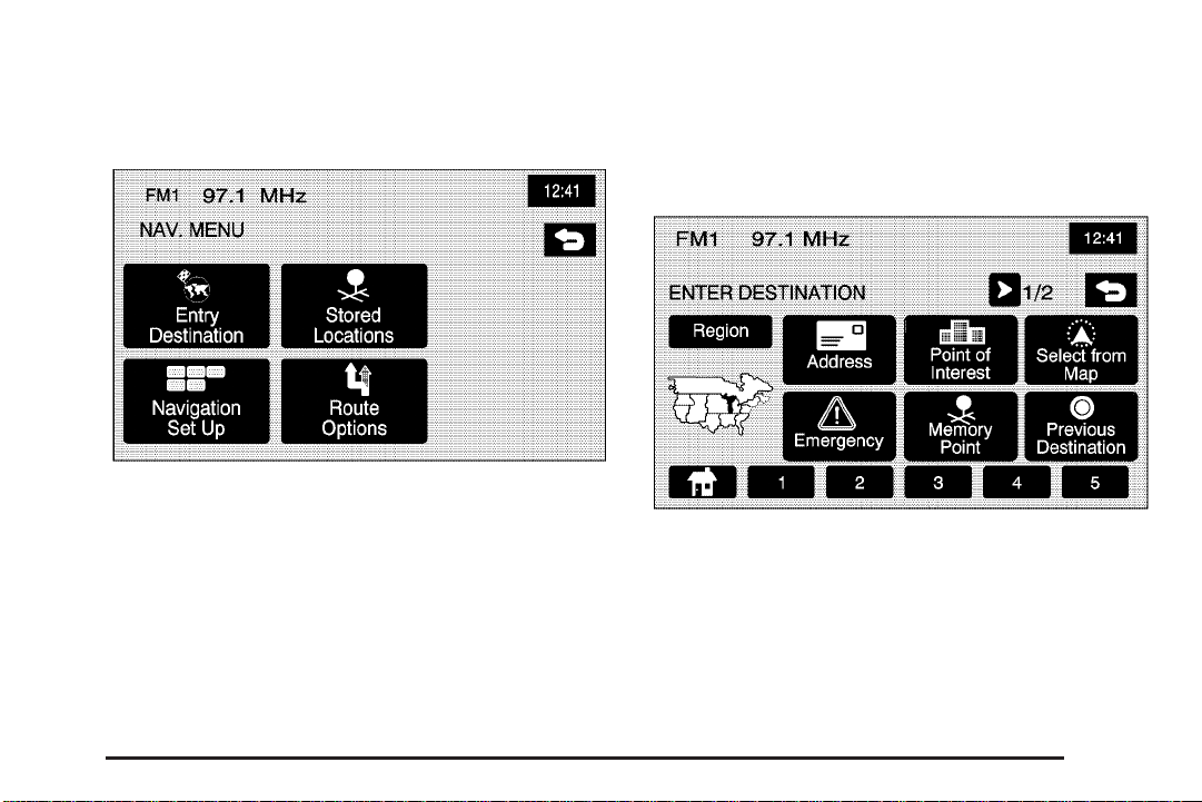
Nav. (Navigation) Menu
Enter Destination
Press the NAV hard key to access the map screen.
Press the MENU touch screen button on the map screen.
From this screen you can access all of the Navigation
System features.
Press the < ENTER DESTINATION touch screen
button to access the ENTER DESTINATION screen.
From this screen, you can choose from several options
to plan a route by entering destination points.
The ENTER DESTINATION screen allows you to
also select the area included in the search for your
destination. A map of the United States and a part of
Canada divided into 11 regions is shown.
Before selecting a method of destination entry, review
the search area map to make sure your destination
is located in the highlighted region.
2-5
Page 12
If you need to see a list of states included in the
highlighted region, or to change the region, touch the
Region touch screen button from the ENTER
DESTINATION screen. The SEARCH AREA screen will
be displayed. Touch the numbered screen button to
the left of the search area map that corresponds with the
numbered region you wish to choose or to view a list
of states included in the region selected. You may also
touch the down arrow to the left of the search area
map to choose CAN for Canada. Once your selection
has been made, you will see the area covered on
the map highlighted. Touch the back key to return to
the ENTER DESTINATION screen.
To enter a destination, choose from one of the following
destination entry methods:
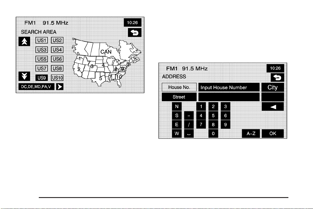
Address
The address destination entry method allows you to
input an address by providing the system with a house
number, street name, and city.
If you choose Any City, the system will generate a list
of all cities containing that street name. If you choose
5 Nearest Cities, the system will generate a list of
the five nearest cities containing that street name.
2-6
Page 13

2 Address: Touch this screen button to access the
ADDRESS screen. At this point you can choose to
enter the address one of three ways, either house
number first, street first or city first.
To use this destination entry method, house number
first do the following:
1. Touch the numeric keypad to input the house
number.
2. Touch the Street button to enter the street name
using the alpha keypad.
3. A list of available street names will be displayed if
there are less than 5 items available. You may select
the list screen button at any time to view the available
list. Select the correct street from the list.
4. The Navigation System will either go the City
input screen or to a list of available cities based
on the input.
5. Touch the desired city name on the list to select it.
6. Choose a destination from the list, and press OK.
A map screen will then appear with the destination
marked.
To use this destination entry method, street name first
do the following:
1. Select the Street screen button from the address
menu and start inputting the street name using the
alpha keypad. A list of available street names
will be displayed if there are less than 5 items
available. You may select the list screen button at
any time to view the available list.
2. Select the desired street name with the correct
prefix from the list.
3. The Navigation System will either go to the City
screen or to a list of available cities. Either enter
the City name using the alpha keypad or select the
correct city from the list.
4. The numeric keypad will be displayed, allowing you
to enter the house number.
5. Press OK.
A map screen will then appear with the destination
marked.
2-7
Page 14
To use this destination entry method, city name first do
the following:
1. Touch the City button.
2. Select from the choices shown on the City screen,
Any City, 5 Nearest Cities, Input City Name, or from
the Last 5 Cities used.
3. If using the alpha keypad, finish inputting the city
name and then select the city from the list
displayed. If choosing from one of the prior
mentioned lists, select the city from the list
displayed.
4. The House number screen will be displayed. Input
the house number using the numeric keypad.
5. The Street input screen will be displayed. Input the
street name using the alpha keypad. A list of
available street names will be displayed if there are
less than 5 items available. You may select the list
screen button at any time to view the available list.
6. Select the desired street name with the correct
designation (Dr., Ln, St., etc.) from the list
7. Press OK.
A map screen will then appear with the destination
marked.
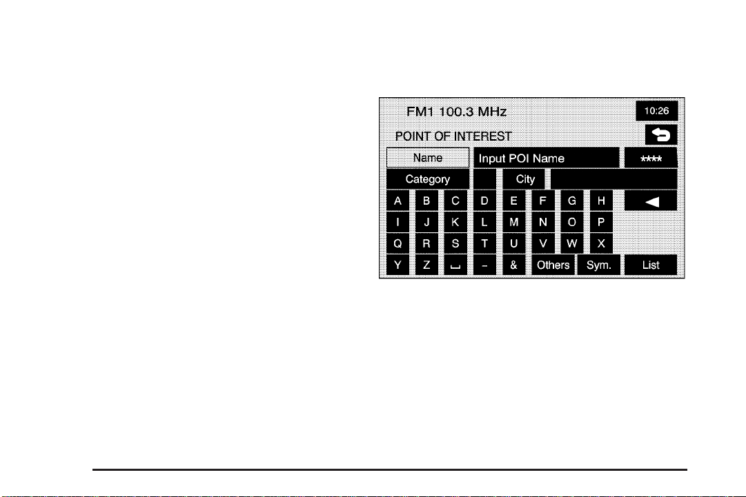
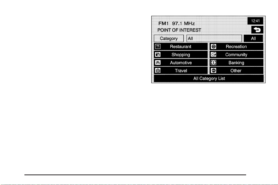
Point of Interest (POI)
The Point of Interest (POI) destination entry method
allows you to choose a destination from the POI list.
K Point of Interest: Touch this screen button to
access the POINT OF INTEREST screen. From
this screen you have three options to select/input your
destination. You can either input the name using
the alpha keypad, select a category from the category
list or select the city by touching the city name and then
using the alpha keypad.
2-8
Page 15
Then, to use this destination entry method by inputting
the name, do the following:
1. Use the alpha keypad to enter the POI name.
Touch Sym. to view a list of symbols and numbers
to add when entering a POI, touch Others to
view a list of special characters you can choose
from, or touch A - Z to return to the alpha keypad.
2. A list of POIs will appear using the information from
the alpha keypad input. You may also touch the
List button at any time to view available POIs.
3. Select the desired POI from the list.
4. Select the desired city from the list or input the city
name using the alpha keypad.
5. Press OK.
A map screen will then appear with the destination
marked.
To use this destination entry method by selecting a
category, do the following:
1. You may also touch Category from the POINT OF
INTEREST screen to view a list of POI categories.
2. Choose a category, and then a sub-category.
3. The Navigation System will display available POIs
names in the selected sub-category or if the list is
too long the system will display the alpha keypad.
4. If the alpha keypad is displayed, input the POI name
until a list of available POIs appears.
2-9
Page 16

5. Select the POI from the list.
6. A list of cities will be displayed. Select the desired
city from the list.
7. Press OK.
A map screen will then appear with the destination
marked.
To use this destination entry method by selecting a city,
do the following:
1. Select the city screen button, then choose from
Any City, 5 Nearest Cities, Input City Name or
from the last 5 cities list. If you choose Any City,
the system will return to the name POI input
method/screen. If you choose 5 Nearest Cities,
the system will generate a list of the five nearest
cities to your current position. Or you can select
from the last 5 cities that were used.
2. Input the city name using the alpha keypad.
3. Select the desired city from the list displayed.
4. Use the alpha keypad to enter the POI name.
Touch Sym. to view a list of symbols to add
when entering a POI, touch Others to view a list
of special characters you can choose from, or
touch A - Z to return to the alpha keypad.
5. A list of POIs will appear if there are fewer than
five POIs found using the information from the
alpha keypad input. You may also touch the
List button at any time to view available POIs.
6. Select the desired POI from the list.
A map screen will then appear with the destination
marked.
2-10
Page 17
Map
The map destination entry method allows you to choose
a destination by scrolling on the map.
I Select from Map: Touch this screen button to enter
the map destination entry method.
Then, to use this destination entry method, do the
following:
1. Touch the map for the desired area you wish to set
as your destination.
2. Use the zoom in/out function to view the direction of
the desired area.
3. Pressing/holding and dragging on the map will
activate fast scrolling. Press/touch once on the
area to which you would like to move the current
position mark.
4. On the map screen you will then see the destination
marked and the address information for the current
destination mark.
2-11
Page 18
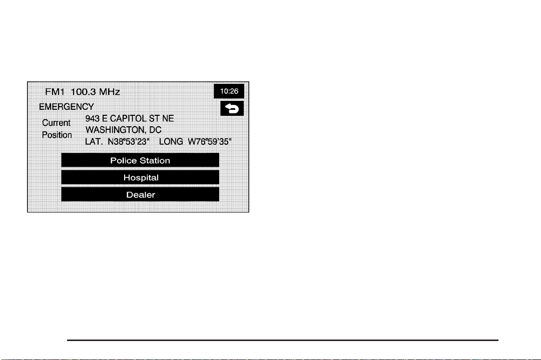
Emergency
The emergency destination entry method allows you to
enter a destination by choosing from three categories:
Police Station, Hospital, or Dealer.
| Emergency: Touch this screen button to access
the EMERGENCY screen. When in this screen, the
system will display your current position address and the
longitude and latitude information.
Then, to use this destination entry method, do the
following:
1. Choose a category.
2. Choose a destination point from the list. Touch
Name Sort to sort the list by name, or Dist Sort
to sort the list by distance from the vehicle’s current
position.
After choosing a destination from the list, a map
screen will then appear with the destination marked.
2-12
Page 19
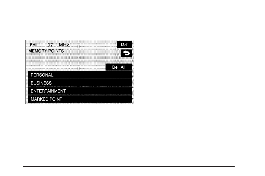
Memory Points
The memory points destination entry method allows you
to choose a destination from a list of points that have
been previously stored.
N Memory Points: Touch this screen button to access
the MEMORY POINTS screen.
Then, to use this destination entry method, do the
following:
1. Select the category/folder in which the memory
point has been stored. Choose from PERSONAL,
BUSINESS, ENTERTAINMENT or MARKED POINT
folders.
2. You can sort the list by distance, icon, name or
date stored.
3. Select the desired memory point.
After choosing a destination from the list, a map
screen will then appear with the destination marked.
2-13
Page 20
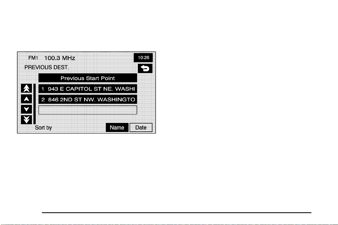
Previous Destination
The previous destination entry method allows you
to choose a destination from a list of previous
destination points.
h Previous Destination: Touch this screen button to
access the PREVIOUS DEST screen. The system
will store up to 100 points that have been previously
input. As new destinations are entered, the system will
automatically delete the oldest destinations and add
the new entries.
Then, to use the previous destination entry method, do
the following:
1. Choose a previous destination from the list. Use
the Sort by Name/Date function as necessary.
Also from this menu you can select the previous
start point option. This option is available while the
vehicle is moving.
1.1. To use the previous start point option from
the PREVIOUS DEST screen, choose the
Previous Start Point screen button.
1.2. The system will plan a route to the previous
point you were at when a route was entered.
2. After choosing a destination from the list, a map
screen will then appear with the destination
marked.
2-14
Page 21
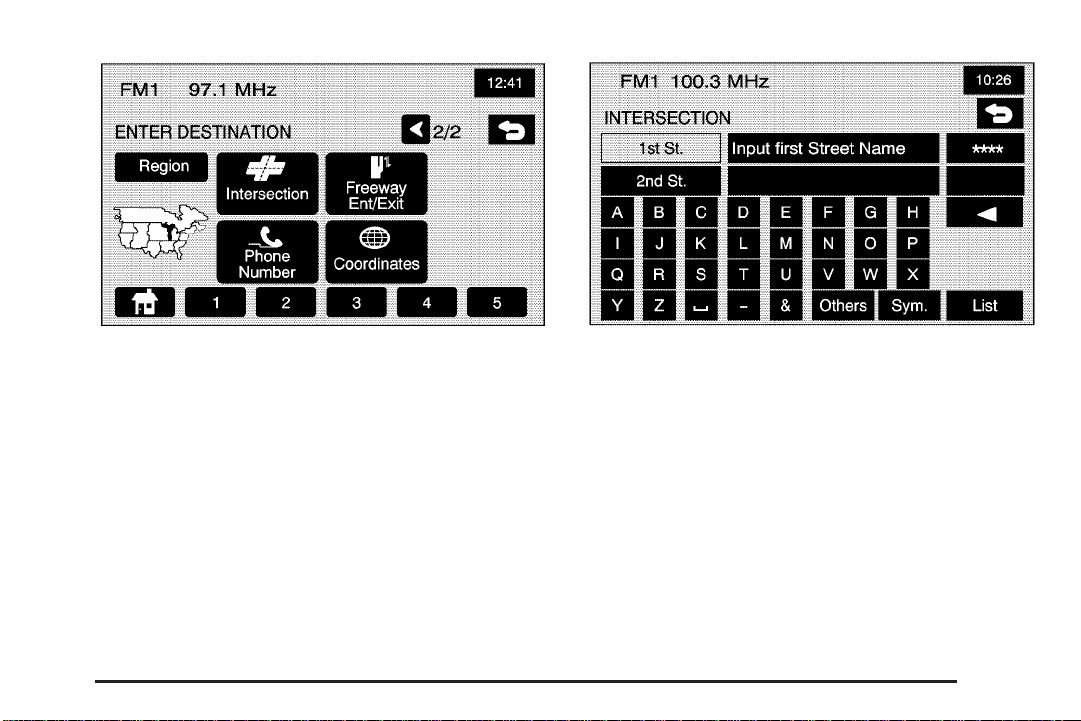
Intersection
The intersection destination entry method allows you
to set two intersecting streets as your destination.
? Intersection: Touch this screen button to access
the INTERSECTION screen.
To enter a destination using the intersection entry
method, do the following:
1. Enter the first of two streets in the intersection.
The List option may become available.
2. You may now choose a street from the list, or
continue to spell the street name to further
reduce the number of available items.
3. After the first street has been chosen, enter the
second street name. The List option may again
become available.
2-15
Page 22
4. You may now choose the second street from the
list, or continue to spell the street name to further
reduce the number of available items.
After both streets have been chosen, a map screen
will then appear with the destination marked.
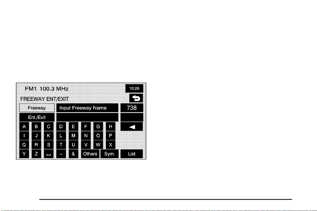
Freeway Entrance/Exit
The freeway entrance/exit destination entry method
allows you to choose a destination by entering a freeway
entrance or exit point.
= Freeway Ent (Entrance)/Exit: Touch this screen
button to access the FREEWAY ENT/EXIT screen.
Then, to use this destination entry method, do the
following:
1. Enter the freeway name. Be sure to use
abbreviations, such as I - 75, rather than spelling
out Interstate.
A list of freeways will appear.
2. Choose a freeway from the list, and choose
whether you want an entrance point or an exit point.
You can choose an exit/entrance point from the
list or input it by name. You can sort the list by name
or by distance.
After choosing a point from the list, a map screen
will then appear with the destination marked.
2-16
Page 23
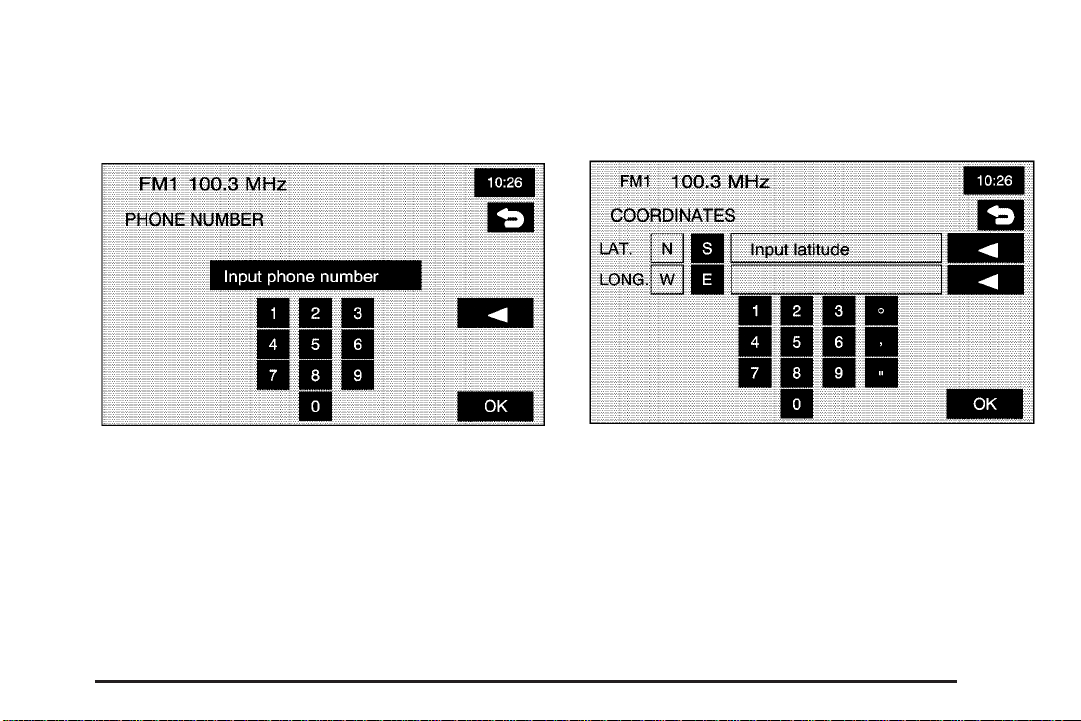
Phone Number
The phone number destination entry method allows you
to choose a destination by entering a phone number
that is contained on the map DVD.
Coordinates
The coordinates destination entry method allows you to
choose a destination by entering latitude and longitude
coordinates.
U Phone Number: Touch this screen button to
access the PHONE NUMBER screen.
Then, to use this destination entry method, do the
following:
1. Input the phone number of a POI using the
numeric keypad.
2. If the phone number can be found on the map
DVD, a map screen will then appear with the
destination marked.
) Coordinates: Touch this screen button to access
the COORDINATES screen.
2-17
Page 24

Then, to use this destination entry method, do the
following:
1. Touch N or S next to LAT to enter the direction of
the latitude coordinate.
2. Input the numeric portion of the latitude coordinate
using the keypad.
3. Touch E or W next to LONG to enter the direction
of the longitude coordinate.
4. Input the numeric portion of the longitude coordinate
using the keypad.
5. Once both coordinates are entered, touch the OK
screen button.
A map screen will then appear with the destination
marked.
If the coordinates are outside of the coverage area on
the map, you will be informed that there is no information
on that location.
Preset Destination
The preset destination entry method allows you to set a
destination by choosing from one of five previously
stored destinations. Besides home, these are the only
destinations available to set while the vehicle is moving.
To store a preset destination see Stored Locations on
page 2-22.
To use this destination entry method, do the following:
1. From the ENTER DESTINATION screen, select
the preset destination number button desired.
The touchscreen buttons are located on the bottom
of the screen.
2. A map screen will then appear with the destination
marked.
Home
This feature allows you to plan a route to one previously
stored destination that you have selected as a home.
If a home destination is not stored, the home button will
not be available. Besides preset destinations one
through five, this destination is the only other one
available to set while the vehicle is moving or by voice
recognition. To store a home location, see Stored
Locations on page 2-22.
L (Home): Touch this screen button to set your
destination as home.
2-18
Page 25
To use this destination entry method, do the following:
1. From the ENTER DESTINATION screen, touch
the Home button.
2. The system will then set your preset home
destination as the current destination.
3. A map screen will then appear with the destination
marked.
Once your destination entry is complete, regardless
of which method of entry you used, a map screen with
the destination previewed will be displayed. You
can change route preferences, route options, map
appearances, or add a waypoint at this time. You may
also set the destination without making any further
changes. See “Getting Started on Your Route” following
in this section for more information on your choices
once a destination has been entered.
Getting Started on Your Route
Once you have entered a destination, you can perform
one of the following options:
h (Destination): Touch the destination symbol to
set the entered destination as it is, without further
adjustment.
o (Waypoint): Touch the waypoint symbol to enter
this point as a waypoint along the route. This feature
allows you to enter up to five stops on the way to your
destination. In order to start the route guidance, a
destination must be entered.
2-19
Page 26

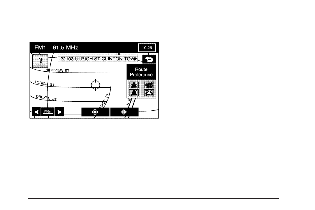
Route Preference: Touch this screen button to access
the ROUTE PREFERENCES screen and adjust the
route preferences. The current setting is displayed in
the Route Preference section of the Map screen.
See “Route Pref.” under Route Options on page 2-36
for more information.
Once the route preferences have been set, the system
will display the map screen.
Chg. (Change) Route: Touch this screen button to
go to the Route Options menu. See Route Options
on page 2-36 for more information.
Three Routes
To access this screen, touch the 3 routes button on the
Map Screen.
You will then get a map screen showing the
three different routes available.
2-20
Page 27

The system will calculate up to three different versions
of your current route in three different colors: Quick,
Normal, and Short. The routes are shown with distance
to destination and estimated travel time. Touch the
button corresponding to the route you want to choose.
Touch Info on the three routes screen to access the
INFO FOR 3 ROUTES screen. From this screen,
you can view the following information:
G (Estimated Travel Time): This icon shows the
route’s estimated time of travel.
J (Straight-Line Distance): This icon shows the
route’s straight-line distance to destination.
2-21
Page 28

W (Toll Road): This icon shows the distance traveled
on toll roads.
c (Freeway Travel): This icon shows the distance
traveled on freeways.
b (Ferry): This icon shows the distance traveled
by ferry.
{ (Time Restricted Roads): This icon shows the
distance traveled on time-restricted roads.
Stored Locations
Memory Points
Choosing the N Stored Locations screen button from the
Nav. Menu will take you to the STORED LOCATIONS
screen. From this screen, you can access the following
options:
N Memory Points: This feature allows you the
ability to store memory points. You can store them
in the four categories listed, Personal, Business,
Entertainment, and Marked Point. These category
names can be changed for your convenience.
2-22
Page 29

To store a point:
1. Touch the Memory Points screen button from the
STORED LOCATIONS screen.
2. Select one of the folders/categories listed.
3. Select the Add screen button.
4. Select the desired method of entering a destination
to enter the memory point. See Enter Destination
on page 2-5 for more information. A map screen will
appear displaying the selected memory point
location.
5. If available, touch the INFO button to view the
address information of the selected point.
6. Touch OK to store the point as a memory point.
To edit a the name of a stored point:
1. Touch the Memory Points screen button from the
STORED LOCATIONS screen.
2. Select one of the folders/categories listed.
3. Select the List screen button.
4. Select the memory point that you wish to edit. You
can use the sort feature to sort by distance, icon,
name, or date as needed.
5. Touch the Name screen button from the EDIT
MEMORY POINT screen.
6. Use the backspace screen button to delete the
current name or use the alpha keypad to make
changes.
7. Touch the OK screen button to store the change.
To change the icon associated with a memory point:
1. Touch the Memory Points screen button from
the STORED LOCATIONS screen.
2. Select one of the folders/categories listed.
3. Select the List screen button.
2-23
Page 30

4. Select the memory point that you wish to edit. You
can use the sort feature to sort by distance, icon,
name, or date as needed.
5. Touch the Icon screen button from the EDIT
MEMORY POINT screen.
6. Select the desired icon. There are two pages of
icons, a page of icons that have sounds associated
with them, and a no icon button to choose from.
7. The new icon will be displayed in the EDIT
MEMORY POINT screen, next to the Icon screen
button.
You can choose between 52 different icons. Six of
these icons also have sounds associated with them. If
these sound-enhanced icons are used, the associated
sound will be heard when the vehicle is approximately
650 ft (200 m) from the memory point. You can
hear what each of these icons will sound like, by
touching the Sound screen button next to each icon.
To move the memory point from one folder/category
to another:
1. Touch the Memory Points screen button from the
STORED LOCATIONS screen.
2. Select one of the folders/categories listed.
3. Select the List screen button.
4. Select the memory point that you wish to edit.
You can use the sort feature to sort by distance,
icon, name, or date as needed.
5. Touch the Category screen button from the EDIT
MEMORY POINT screen.
6. Touch the new folder/category button you want to
move the memory point to.
7. The Navigation System will display a message
confirming your move.
To modify the position of the stored point:
1. Touch the Memory Points screen button from the
STORED LOCATIONS screen.
2. Select one of the folders/categories listed.
3. Select the List screen button.
4. Select the memory point that you wish to edit.
You can use the sort feature to sort by distance,
icon, name, or date as needed.
5. Touch the Position screen button from the EDIT
MEMORY POINT screen.
6. The Navigation System will display the map screen
with the destination marked. Touch the map to
move the position of the memory point.
2-24
Page 31

7. Touch OK when you have moved the memory point
to the appropriate location.
8. The Navigation System will return to the EDIT
MEMORY POINT screen and will now display
the new address, longitude and latitude for
the changed memory point.
To change the phone number of a memory point:
1. Touch the Memory Points screen button from the
STORED LOCATIONS screen.
2. Select one of the folders/categories listed.
3. Select the List screen button.
4. Select the memory point that you wish to edit.
You can use the sort feature to sort by distance,
icon, name, or date as needed.
5. Touch the Tel. screen button from the EDIT
MEMORY POINT screen.
6. Use the numeric keypad to change the
phone number.
7. Touch OK to store the changed phone number.
To delete a memory point:
1. Touch the Memory Points screen button from
the STORED LOCATIONS screen.
2. Select one of the folders/categories listed.
3. Select the Delete screen button.
4. Select the memory point that you wish to delete
from the DELETE POINT screen. You can use
the sort feature to sort by distance, icon, name or
date as needed.
5. The Navigation System will show the map screen
with the position address and a pop-up confirmation
message. Select Yes to delete the point; select
No to return to the DELETE POINTS screen and not
delete the point.
To delete all of the memory points in a folder/category:
1. Touch the Memory Points screen button from
the STORED LOCATIONS screen.
2. Select the desired folder/category from the
MEMORY POINTS screen.
3. Select the Del.All screen button.
4. The Navigation System will display a pop-up
confirmation message. Select Yes to delete all
the points in the folder/category; select No to
cancel the operation.
To change the name of the folder/category:
1. Touch the Memory Points screen button from
the STORED LOCATIONS screen.
2. Select the desired folder/category from the
MEMORY POINTS screen.
3. Select the Edit Category screen button.
2-25
Page 32

4. Use the alpha keypad to change the name of the
folder/category as desired.
5. Touch the OK screen button to save your changes.
3 Avoid Area: This feature allows you to store an
area to be avoided while planning a route. Up to
10 points can be stored.
To store an avoid area memory point, do the following:
1. Touch the Avoid Area screen button from the
STORED LOCATIONS screen.
2. Touch the Add screen button from the AVOID
AREA screen.
3. Select the desired method of entering a destination
to enter the memory point. See Enter Destination
on page 2-5 for more information. A map screen will
appear displaying the selected memory point
location.
4. If desired, reduce or enlarge the area around the
point you want to avoid by using the Reduce or
Enlarge screen buttons.
It is recommended that when avoiding locations
on freeways, you reduce the avoid area to the
minimum scale. This will produce an X on the map
rather than a box. This will ensure that the
system knows you want to avoid the freeway itself,
not necessarily the area around the freeway.
5. Touch OK to store the area.
To change the name of the point to be avoided:
1. Touch the Avoid Area screen button from the
STORED LOCATIONS screen.
2. Touch the List screen button from the AVOID
AREA screen.
3. Select the point to be changed.
4. Touch the Name screen button.
5. Use the alpha keypad to add to or change
the name.
2-26
Page 33

6. Touch the OK screen button to save your changes.
7. Select the Show Name On screen button if you
would like the name of the point to appear on the
map screen.
To change the position of the point to be avoided:
1. Touch the Avoid Area screen button from the
STORED LOCATIONS screen.
2. Touch the List screen button from the AVOID
AREA screen.
3. Select the point to be changed.
4. Touch the Position screen button.
5. Touch the map to move the location.
6. If desired, reduce or enlarge the area around the
point you want to avoid by using the Reduce or
Enlarge keys.
7. Touch OK to store the area.
To delete a point to be avoided:
1. Touch the Avoid Area screen button from the
STORED LOCATIONS screen.
2. Touch the Delete screen button from the AVOID
AREA screen.
3. Select the point you want to delete. Use the
scrolling arrows as needed.
4. The Navigation System will display the map
screen with the name of the point and a pop-up
confirmation message. Touch Yes to have the
point deleted; touch No to cancel the function.
To delete all of the points to be avoided:
1. Touch the Avoid Area screen button from the
STORED LOCATIONS screen.
2. Touch the Del.All screen button from the AVOID
AREA screen.
3. The Navigation System will display a pop-up
confirmation message. Touch Yes to have all of
the points deleted; touch No to cancel the function
and return to the AVOID AREA screen.
6 Dest. & Way Pt. (Destination & Way Point):
Up to five memory points can be stored as waypoints.
To add a waypoint:
1. Touch the Dest. & Way Pt. screen button from
the STORED LOCATIONS screen.
2. Touch the Add screen button from the DEST. &
WAY POINT screen.
3. Using the desired method of entering a destination,
enter the way point. See Enter Destination for more
information.
4. A map screen will appear with the way point
marked.
2-27
Page 34

5. Select the o (Way point) symbol on the map
screen to save the way point.
6. Repeat Steps 2 - 6 to add up to five way points to
your route. For the second through the fifth way
points added, the Navigation System will display the
ADD WAYPOINT screen.
7. Select the desired location/order that you want
your newly added waypoint to fall in your route
by touching the corresponding Add screen button.
The Add and arrow screen buttons are located
to show where the new way point is placed.
To change the order of the route:
1. Touch the Dest. & Way Pt. screen button from the
STORED LOCATIONS screen.
2. Touch the List screen button from the DEST. &
WAY POINT screen.
3. From the CHANGE ORDER screen, select on the
addresses in the order you would like them to fall
on the route.
4. Select OK to save your changes.
To change the location of a way point:
1. Touch the Dest. & Way Pt. screen button from
the STORED LOCATIONS screen.
2. Touch the List screen button from the DEST. &
WAY POINT screen.
3. Touch the Chg. Loc. screen button from the
CHANGE ORDER screen.
4. From the CHANGE LOCATION screen select the
point whose location needs to change.
5. A map screen will be displayed with the destination
marked. Touch on the map to move the location of
the waypoint.
6. Touch the OK screen button to save your changes.
The Navigation System will return to the STORED
LOCATIONS screen.
To delete a way point from your current route:
1. Touch the Dest. & Way Pt. screen button from the
STORED LOCATIONS screen.
2. Touch the Delete screen button from the DEST. &
WAY POINT screen.
3. Select the way point/destination you want to delete.
4. The Navigation System will display the map
screen with a pop-up confirmation message.
Choose Yes to delete the way point; touch No
to cancel this operation.
To delete all of the way points on your route:
1. Touch the Dest. & Way Pt. screen button from
the STORED LOCATIONS screen.
2. Touch the Del.All screen button from the DEST. &
WAY POINT screen.
2-28
Page 35

3. The Navigation System will display the map
screen with a pop-up confirmation message.
Choose Yes to delete all of the way points;
touch No to cancel this operation.
L Home: This feature allows you to store/delete/edit
a point to be stored as your home destination.
To store your home destination, do the following:
1. Touch the Home screen button from the
STORED LOCATIONS screen.
2. Choose Add to add the destination.
3. Choose a destination entry method from the
SET HOME screen.
4. Set the destination and touch OK.
5. Touch OK on the map screen and the destination
will be stored. The home icon will now be
highlighted on the ENTER DESTINATION screen.
To edit your home destination, do the following:
1. Touch the Home screen button from the STORED
LOCATIONS screen.
2. Choose List from the HOME screen to change the
location.
3. Touch the map to move the location of the point.
4. Touch OK to save your changes.
To delete your home point, do the following:
1. Touch the Home screen button from the
STORED LOCATIONS screen.
2. Choose Delete from the HOME screen.
3. The Navigation System will display the map
screen with a pop-up confirmation message.
Select Yes to delete the home position previously
stored; select No to cancel the operation.
2-29
Page 36

B Previous Dest. (Previous Destination): The
system will automatically store up to 100 points that
have been previously input. As new destinations
are entered, the system will automatically delete the
oldest destinations and add the new entries. See Enter
Destination on page 2-5 for more information.
To delete a specific destination from your previous
destinations list, do the following:
1. Touch the Previous Dest. screen button from the
STORED LOCATIONS screen.
2. Touch the Delete screen button.
3. Select a destination from the list displayed.
4. The Navigation System will display the map screen
with a pop-up confirmation message. Select Yes to
delete the destination previously stored; select
No to cancel the operation.
To delete all destinations from your previous
destinations list, do the following:
1. Touch the Previous Dest. screen button from the
STORED LOCATIONS screen.
2. Touch the Del.All screen button.
3. The Navigation System will display the map screen
with a pop-up confirmation message. Select Yes
to delete all of the destinations previously stored;
select No to cancel the operation.
A Preset Dest. (Preset Destination): This feature
allows you to store up to five preset destinations.
These destinations are stored on the numbered buttons
shown on the bottom of the ENTER DESTINATION
screen.
Storing a Preset Destination
To store a preset destination, do the following:
1. Touch the Preset Dest. screen button from the
STORED LOCATIONS screen.
2. Choose Add to add a preset destination, then
choose the numbered preset icon you would
like it to appear as.
3. Choose a destination entry method from the
STORE PRESET DEST. screen.
4. Set the destination and touch OK.
5. Touch OK on the map screen and the destination
will be stored. It will now be highlighted on the
ENTER DESTINATION screen.
To edit the name of a preset destination, do the
following:
1. Touch the Preset Dest. screen button from the
STORED LOCATIONS screen.
2. Choose the List screen button.
3. Select the preset destination whose name you
want to edit.
2-30
Page 37

4. Touch the Name screen button and use the alpha
keypad to edit or add the name.
5. Touch the OK screen button to save your changes.
The new name will then be displayed.
To change the position of a preset destination, do the
following:
1. Touch the Preset Dest. screen button from the
STORED LOCATIONS screen.
2. Choose the List screen button.
3. Select the preset destination whose position you
want to change.
4. Touch the Position screen button from the EDIT
PRESET DEST. screen.
5. The Navigation System will display the map screen
with the destination marked. Touch the map to
move the position of the memory point.
6. Touch the OK screen button to save your changes.
To add or change the phone number of a preset
destination, do the following:
1. Touch the Preset Dest. screen button from the
STORED LOCATIONS screen.
2. Choose the List screen button.
3. Select the preset destination whose phone number
you want to change.
4. Touch the Tel. screen button and use the numeric
keypad to input or change the phone number.
5. Touch the OK screen button to save your changes.
To delete a preset destination:
1. Touch the Preset Dest. screen button from the
STORED LOCATIONS screen.
2. Select the Delete screen button.
3. Select the memory point that you wish to delete
from the DELETE PRESET DEST. screen.
4. The Navigation System will show the map screen
with the position address and a pop-up confirmation
message. Select Yes to delete the point; select
No to return to the DELETE PRESET DEST. screen
and not delete the point.
To delete all of the preset destinations:
1. Touch the Preset Dest. screen button from the
STORED LOCATIONS screen.
2. Select the Del.All screen button.
3. The Navigation System will display a pop-up
confirmation message. Select Yes to delete all
the preset destinations; select No to cancel
the operation.
2-31
Page 38

Memory Point Icons Display: Choose this feature to
display memory point icons on the map.
Calculate: Touch Calculate to calculate your route.
This button is available after a destination has been set.
Navigation Set Up
I Navigation Set Up: Touch this screen button to
access the NAVIGATION SET UP screen.
From this menu, several options are available for
adjustment:
8 2D/3D View: This option allows you to change
the view of the map between a 2-dimensional and
3-dimensional view.
C Quick POI Selection: This option allows you to
choose what POIs you want available on the Quick
POI (Q-POI) screen. The Quick POI screen can
be accessed by touching the map screen and selecting
the POI button the Quick POI screen is available
when the scale is
1
⁄2mile (1 km) or less.
2-32
Page 39

Select a POI category or the All Category List to get to
the Quick POI screen.
To select a POI, touch the screen button of the POI you
want to change. A list of POI categories will be displayed.
Select a POI category or the All Categories list. Select a
POI from the list. This POI will now be available on the
Q-POI screen.
2-33
Page 40

5 Calibration: This option allows you to recalibrate
the navigation system.
J User Settings: This option allows you to turn on
and off several other route options.
Once you enter the Calibration screen, you have the
choice to either adjust your vehicle’s position or to
adjust the vehicle speed signal.
To correct the position of your vehicle on the map
(if your vehicle has been shipped, for example) or to
change to the current position, touch the
Position/Direction screen key.
If there are tire pressure differences or a spare tire is
installed, the Navigation System will automatically
re-calibrate the system but it may take longer.
To calibrate the vehicle speed signal, touch the
Distance screen key.
2-34
From this screen, you can adjust the following:
Road Restriction Warnings: This option instructs
the system to notify you when the current route
has traffic restrictions.
Arrival Time
display the estimated time of arrival to your destination.
Arrival Time
will display the amount of drive time estimated to arrive
at your destination.
G (Time of Arrival): This option will
\ (Time to Destination): This option
Page 41

Guidance Screen: This option will turn the guidance
screen on and off.
Freeway Information: This option will display freeway
exit information. This is only available on freeways
during route guidance.
D Restore System Defaults: Select this option
from the NAVIGATION SET UP screen to change
all adjustable system settings to factory defaults.
> Guidance Volume: This option allows you to adjust
the volume of voice guidance prompts. You may also
choose to turn voice guidance prompts off.
2-35
Page 42

Route Options
H Search Conditn (Search Condition): This
option will take you to the SEARCH CONDITION screen.
Selecting Change Route from the Nav. Menu will take
you to the ROUTE OPTIONS menu. This menu has
many options you can use to customize your route
guidance. To take advantage of these features, a route
must first be entered. See Enter Destination on
page 2-5 for more information on entering a destination.
2-36
The search condition screen allows you to view your
current destination and also change the planning
methods between each destination. Each distance
between waypoints and final destination can have an
individual setting. Use the up/down arrows to scroll
through your routes. Use the available route preference
options to change your planning method. After
selecting the new planning methods, touch Calculate
to plan the route.
Page 43

7 Detour: You can select a detour if there is
construction work, or traffic delays that prevent the
original route from being used.
From this screen, you can select a 1 mile, 3 mile, or
5 mile detour or you may also choose to detour
the whole route if necessary. After selecting the detour,
the system will calculate the alternate route and you
will see the new route on the map screen.
F Route Pref. (Route Preferences): You can select
to have certain types of roads/ferries included in
your route planning. See “Getting Started on Your
Route” under Enter Destination on page 2-5 for more
information.
The following route preferences can be selected on or off:
c (Allow Major Roads): This feature allows the
system to use expressways when calculating a route.
If there is no way to reach your destination without using
major roads, the system will automatically route you
on these roads.
2-37
Page 44

l (Allow Time Restricted Road): This feature
allows the system to use time restricted roads when
calculating a route. These are roads that may be
closed during the winter season.
W (Allow Toll Road): This feature allows the
system to use toll roads or pay roads when calculating
a route.
b (Allow Ferry): This feature allows the system to
use ferries when calculating a route.
If any of these features are turned off, the button will
be dark and there will be a red slash through its
icon when seen on the map screen.
Once the route preferences have been set, select the
back button to return to the previous screen.
o Dest. & Way Pt. (Destination and Waypoint):
You can edit the selected destination and waypoints
using this screen.
Up to five waypoints and one destination can be
entered. The following functions are available:
Add: This will take you to the Store Dest. & Waypoint
screen. You can add a waypoint or change the
destination. See Enter Destination on page 2-5 for more
information on entering a destination.
List: This allows you to change the order of the stops
in the route and to change the location of the stops.
Delete/Del. All: These allow you to delete waypoints on
the route or to delete the entire route.
2-38
Page 45

9 Display route: From this screen, you can view the
entire route, including the start point and destination,
the time it will take to reach your destination, and
distance, including the distance that is routed on each
road type.
The route can be edited by pressing the Turn List
screen button. A list is displayed with every turn
contained in the route. While viewing these turns, you
have an opportunity to avoid certain streets on the route.
To avoid a street, select the Avoid screen button for
that particular turn. To cancel the avoided turn, select
Avoid again to deselect it. After you have selected Avoid
for every street you would like to detour, press Reroute
to replan the route.
If you would like to cancel an avoided turn after the
route has been replanned, press Delete. This will bring
up a list of all of the avoided turns. Select the street
that you want to remove from the avoid list.
2-39
Page 46

G Route Preview: From this screen, you can
preview the entire route in either direction, as well as
edit the route.
q (Scroll to Start Point): Touching this screen button
will start a smooth scroll of the route backwards to
the start point, previous waypoint, or the previous
available POI, depending on the mode selected.
Repeatedly touching this button will increase or
decrease the scroll speed.
j(Pause): Touching this screen button will pause
the smooth scroll. Pushing one of the scroll buttons
(
qr) will restart the scroll.
r (Scroll to Destination): Touching this screen
button will start a smooth scroll of the route toward the
destination, next waypoint or next available POI,
depending on the mode selected. Repeatedly touching
this button will increase or decrease the scroll speed.
Use the touch-sensitive screen buttons at the bottom
of the navigation screen to move forward or backward
through the route.
t(Skip to Start Point): Touching this screen button
will skip backward to the start point, the previous
waypoint, or the previous available POI, depending on
the mode selected.
2-40
u (Skip to Destination): Touching this screen button
will skip forward to the destination, next waypoint or
next available POI, depending on the mode selected.
Info (Information): When the skip/scroll functions
are used and the cursor stops at a POI, this screen
button will appear. Touching it will provide information
regarding the POI, including the POI name, address,
city and phone number.
Page 47

Edit: Touch this screen button to change the way the
skip/scroll function operates. You can select to have the
skip/scroll go to the start point/destination or to the
next available POI or waypoint.
To next Dest. (Destination) or WP (Waypoint):
Choosing this option will cause the skip/scroll functions
to skip/scroll to the next destination or waypoint.
To next POI: In order to select this option, a POI
category must be selected. When you choose this
option, the skip/scroll functions will skip/scroll to
the next available POI for the category chosen.
To change the POI category, touch the corresponding
screen button next to the category desired. You can
choose to select no POIs by touching the Delete screen
button. The default POIs are the same as those in
the Quick POI group listing.
Calculate: Touch this screen button to calculate the
route containing any options you may have adjusted.
If you chose to calculate your route, this screen will
be displayed. From this map screen, you can touch
Guide to begin route guidance, or Chg. route to
return to the ROUTE OPTIONS screen.
Cancel Guidance: Touch this screen button to cancel
the current route.
2-41
Page 48

Maps
This section includes basic information that you need
to know about the map database.
Regional Maps
The maps are stored on a DVD. The 48 contiguous
United States and portions of Canada are contained
on one disc.
If a regional map does not contain a specific city, the
map DVD may not contain the city or it may be
misspelled.
Refer to the Navigation System Map Disc manual to
view a detailed explanation of map coverage and
detailed city lists in each region. This manual will be
in your map DVD case when the vehicle is delivered
from the factory.
Installing the Map DVD
When your vehicle is delivered from the factory, the
dealer may have installed the map DVD. If the map DVD
was not installed in your vehicle when first purchased,
use the following directions to load the map DVD:
Read the following steps completely before operating
this feature.
1. Turn the ignition on.
2. Push the
faceplate will open.
3. Load the map DVD into the DVD slot by inserting it
partially until the system pulls it in.
4. Wait until the DVD is loaded properly and then
push the
close the faceplate.
Once the map DVD is inserted correctly, the system will
display the CAUTION screen.
Agree: Touch this screen button to proceed to the
navigation system.
The map will appear showing your current vehicle
position.
Z (open/close faceplate) button and the
Z (open/close faceplate) button to
2-42
Page 49

Setting the Search Area
See Enter Destination on page 2-5 for information on
changing the search area.
Map Adjustments
The system allows you to adjust the scale of view
on the map. Also, as you drive, the map will scroll
automatically based on the direction you are traveling.
Scrolling the Map
Touch anywhere on the
map screen twice and the
scroll symbol will appear.
Use this feature to
scroll across the map.
Map Scales
To view a larger or smaller
scale of the map, touch
the map scale arrows.
You can change the level of map detail by either
zooming in or zooming out using the arrow screen
buttons or by touching the scale on the bar. The
system will adjust the map accordingly. The scale of
a map can range from 1/32 of a mile (0.05 km) to
128 miles (256 km).
If scrolling while your vehicle is in PARK (P), the system
will scroll initially at a slower rate. It will increase if
you continue touching the map screen.
If scrolling while your vehicle is in motion, the system
will scroll to that location and stop.
If you have used the scroll feature to scroll the map
and your vehicle icon becomes lost, press the NAV
(navigation) hard key to return to the current vehicle
location on the map.
You can use the scroll feature on the map to set a
destination. See “Map” under Enter Destination
on page 2-5 for more information.
2-43
Page 50

Symbols
The following symbols are the most common symbols
that will appear on a map screen.
This symbol will appear on
the map after a route has
been planned marking
your final destination.
When a waypoint has
been planned, you will
see this symbol on
the map.
The waypoint symbol will be numbered from one
through five depending on how many waypoints have
been set.
This symbol indicates the
distance to your final
destination. It only appears
when time is not available.
This symbol indicates
the distance and the
estimated time remaining
to your final destination
or arrival time, depending
on the option selected.
See Navigation Set Up
on page 2-32 for more
information.
2-44
Page 51

This symbol shows the
straight-line distance to
your destination.
This symbol may appear before you start driving on the
route or if you are on a road where navigation
guidance cannot be given.
This symbol indicates
the map with North Up,
known as North Up mode.
While in North Up mode, North will always be at the
top of the screen. Touch this screen symbol to switch
between North Up and Heading Up modes.
This symbol indicates the
map with the vehicle travel
direction up, known as
Heading Up mode.
The shaded triangle indicates the North direction.
While in Heading Up mode, the direction your vehicle is
traveling will always be at the top of the map screen.
The vehicle icon will always be headed in the direction
your vehicle is traveling. Touch this screen symbol
to switch between Heading Up and North Up modes.
y (No GPS): This symbol will appear in the upper right
corner of the map screen when your vehicle is not
receiving a Global Positioning System (GPS) satellite
signal. See Global Positioning System (GPS) on
page 2-48 for more information.
2-45
Page 52

When a name is too
long to be displayed, an
arrow symbol will appear.
Touch the right or left
arrow screen button
to scroll through the
entire name.
This symbol indicates
the position of the next
guidance maneuver.
The following symbols can also be found on a
map screen:
Touch this symbol to
display the scale on
the map, allowing you
to zoom in and out.
I (Current Position): Your vehicle is shown as this
symbol. It indicates the current position and heading
direction of your vehicle on the map.
O (Map Appearance): Touch this symbol to change
the map appearance.
P (Single Map Mode): Touch this symbol to change
the guidance window to single map mode.
Q (Dual Map Mode): Touch this symbol to change
the guidance window to dual map mode.
2-46
Page 53

R (Turn List): Touch this symbol to change the
guidance window to display turn list guidance on the
map screen when under Route Guidance.
S (Next Turn): Touch this symbol to change guidance
mode to display mode guidance on the map screen
when under Route Guidance.
T (Guidance Screen): Touch this symbol to display
only the next maneuver along with a small map of
the maneuver. This map will pop up when you
are approaching a turn. This option can be turned off
by the USER SETTINGS screen.
c (Highway Guidance): Touch this symbol to display
highway guidance on the map screen.
h (Destination): Touch this symbol to set the current
route as the destination.
o (Waypoint): Touch this symbol to enter a waypoint
along the current route.
N (Memory Point): Touch this symbol to store the
location on the screen as a memory point.
Auto Reroute
When your destination is set and you are off the
planned route, the system will automatically plan a new
route and begin to reroute. You will be able to see
the new route highlighted on the screen.
Traveling Across Regions
If you plan to drive across many states, you may have
to change the region selected to represent the area
you are traveling to. To do so, do one of the following:
1. Change the selected region in the search area
when you get closer to the area you are traveling
to. See Enter Destination on page 2-5.
2. Change the selected region in the search area
when entering your destination and route settings.
See Enter Destination on page 2-5.
For example, if you were traveling from Michigan to
Florida, change the region currently selected in
the search area to Florida. Enter a destination in
Florida under the ENTRY DESTINATION menu.
2-47
Page 54

Global Positioning System (GPS)
The Navigation System determines the position of your
vehicle by using satellite signals, various vehicle
signals and map data.
At times, other interferences such as the satellite
condition, road configuration, the condition of the vehicle
and/or other circumstances can interfere with the
Navigation’s ability to determine the accurate position
of the vehicle.
The GPS shows the accurate current position of your
vehicle using signals sent by the GPS Satellites of
the United States Department of Defense. When your
vehicle is not receiving signals from the satellites,
a symbol will appear on the map screen. Refer to
Symbols on page 2-44.
This system may not be available/or interference may
occur if the following happens:
• Signal obstructions caused by tall buildings, large
trucks, tunnels,
• objects located on top of the instrument panel,
• satellites will not send signals if they are being
repaired or improved,
• after-market glass tinting has been applied to the
vehicle’s windows.
Notice: Do not apply after-market glass tinting to
the vehicle’s windows. Glass tinting will interfere
with the system’s ability to receive GPS signals and
cause the system to malfunction. You might have
to replace the window to correct the problem.
This would not be covered by your warranty.
For more information if you are experiencing a problem,
see If the System Needs Service on page 2-50 and
Problems with Route Guidance on page 2-49.
Vehicle Positioning
At times, the position of the vehicle on the map may be
inaccurate due to one or more of the following reasons:
• The road system has changed.
• The vehicle is driving on slippery road surfaces
such as in sand, gravel and/or snow.
• The vehicle is traveling on winding roads.
• The vehicle is on a long straight road.
• The vehicle is approaching a tall building or a
large vehicle.
• The surface streets run parallel to a freeway.
• The vehicle has just been transferred by a vehicle
carrier or a ferry.
2-48
Page 55

• The current position calibration is set incorrectly.
• The vehicle is traveling at high speed.
• The vehicle changes directions more than once,
or when the vehicle is turning on a turn table in a
parking lot.
• The vehicle is entering and/or exiting a parking lot,
garage or a lot with a roof.
• The GPS signal is not received.
• A roof carrier is installed on your vehicle.
• The vehicle is equipped with tire chains.
• The tires are replaced.
• The tire pressure for your tires is incorrect.
• The tires are worn.
• The first time the map DVD is inserted.
• The battery is disconnected for several days.
• The vehicle is driving in heavy traffic where driving is
at low speeds, and the vehicle is stopped and started
repeatedly.
If you experience problems with your system, you
may need to calibrate the system. This may be due to
tire pressure differences, or if a spare tire is installed.
To calibrate the system, see Navigation Set Up
on page 2-32.
Problems with Route Guidance
Inappropriate route guidance may occur under one or
more of the following conditions:
• You have not turned onto the road indicated.
• Route guidance may not be available when using
automatic rerouting for the next right or left turn.
• The route may not be changed when using
automatic rerouting.
• There is no route guidance when turning at an
intersection.
• Plural names of places may be announced
occasionally.
• It may take a long time to operate automatic
rerouting during high-speed driving.
• Automatic rerouting may display a route returning to
the set waypoint if you are heading for a destination
without passing through a set waypoint.
• The route prohibits the entry of a vehicle due to a
regulation by time or season or any other regulation
which may be given.
2-49
Page 56

• Some routes may not be searched.
• The route to the destination may not be shown
if there are new roads, if roads have recently
changed or if certain roads are not listed on the
map DVD. See Ordering Map DVDs on page 2-50.
To recalibrate the vehicle’s position on the map, see
Navigation Set Up on page 2-32.
If the System Needs Service
If your system needs service and you have followed the
steps listed here and still are experiencing problems,
see your dealer for assistance. For more information
on calibrating the system, see Navigation Set Up
on page 2-32.
Ordering Map DVDs
The map DVD in your vehicle is the most up-to-date
information available when your vehicle was purchased.
The map DVD is updated once a year, provided that
the map information has changed. To order a new map
DVD, contact your dealer.
Database Coverage Explanations
The United States, excluding Alaska and Hawaii, and
portions of Canada are contained on one DVD disc.
The map database contains three different levels
of coverage: detailed areas, non-detailed areas and
limited guidance areas. Detailed areas are available
for the United States and Canada and are primarily
located around metropolitan areas. Limited guidance
areas are only available for the United States.
The roads are displayed on the map, but route and
voice guidance is not available. Non-detailed areas
are available for Canada only. Major roads are
included depending upon available coverage.
For more detailed information on database coverage,
see the Navigation System Map Disc manual included
inside the map DVD case.
2-50
Page 57

Section 3 Navigation Audio System
Navigation Audio System ..................................3-2
CD Player ...................................................3-14
3-1
Page 58

Navigation Audio System
Notice: Before adding any sound equipment to
your vehicle, like a tape player, CB radio, mobile
telephone, or two-way radio, make sure that it can
be added by checking with your dealer. Also,
check federal rules covering mobile radio and
telephone units. If sound equipment can be added,
it is very important to do it properly. Added
sound equipment may interfere with the operation
of your vehicle’s engine, radio, or other systems,
and even damage them. Your vehicle’s systems may
interfere with the operation of sound equipment
that has been added improperly.
Your vehicle has a feature called Retained Accessory
Power (RAP). With RAP, the audio system can be
played even after the ignition is turned off. See
“Retained Accessory Power (RAP)” your vehicle’s owner
manual for more information.
The audio system is operated using navigation system
menus. The audio menus are explained in this section.
Playing the Radio
PWR-VOL (Power-Volume): Press this knob to turn
the audio system on and off. Turn the knob to increase
or decrease the volume to the audio system.
e/ z (Audio/Screen): Press this key to view the
audio and screen settings.
¦O SEEK ¥: Press the up or down arrow to go
to the next or previous station. Press and hold until
a beep is heard to scan to the next station. Press and
hold longer to perform a fast seek operation.
SRCE (Source): Press this hard key to display the
main audio screen.
3-2
Page 59

Speed Compensated Volume (SCV): This feature
allows your audio system to monitor noise in the vehicle
depending on the speed of the vehicle. SCV will
automatically adjust the volume level as your speed
increases so that it always sounds the same to you.
To use SCV, choose between Low, Medium, and High
settings. You may also choose to turn this feature off.
Preset selection: This feature allows you to program
local presets which you can recall by touching HOME.
You may also program presets while you are traveling to
another area and store them under AWAY. See “Preset
Station Menu” later in this section for more information.
The Home and Away feature is not available for the XM™
Satellite Radio audio source, if equipped.
Color Scheme: Select this feature to change the
color of audio and navigation screens. Touch any of
the color options to view the different backgrounds.
The first color option shown is the default option.
3-3
Page 60

Clock
Touch the clock symbol at the bottom of the main audio
screen or touch and hold the time display in the upper
right corner of any menu to get to the CLOCK ADJUST
menu. Touching the time display will also display the date
on the status bar at the top of the screen.
The following time options may be adjusted from
this menu:
HOUR/MIN.: Touch the up or down arrows to increase
or decrease the hour or minutes. Touch and hold an
arrow to advance quickly.
12H/24H: Touch 12H to display the time in standard
time, or 24H to display the time in military time.
GPS TIME: The current GPS time will be displayed to
the right of this button. Touch GPS TIME to set the
navigation system’s time to match current GPS time.
Daylight Saving Time: Touch this screen button
to increase the time setting by one hour, then touch
GPS TIME to save the new setting. If the screen button
is light blue, the daylight savings time feature is on.
If the screen button is dark blue, the daylight savings
time feature is off.
TIME ZONE: The selected time zone will appear to
the right of this screen button. Touch TIME ZONE
to toggle through the available time zones and choose
the desired one. The time of the selected zone will
be displayed to the right of GPS TIME. To set the
system clock to the new setting, touch GPS TIME.
If the system is not receiving GPS information, you
can still set the time manually as described above,
but GPS time and Daylight Saving Time features will
not be available.
Touch the back screen button to go back to the
previous menu.
3-4
Page 61

Screen Adjust
To adjust the contrast or brightness of the screen,
touch SCREEN ADJUST at the bottom of the main
audio screen.
! (Brightness): Touch the plus (+) or minus (−)to
adjust the brightness. Touch OK to confirm the change.
AUTO: This setting automatically adjusts the contrast
and brightness of the screen based on outside
lighting conditions.
DAY: This setting leaves the screen in day mode.
Day mode is best suited for daylight conditions.
NIGHT: This setting leaves the screen in night mode.
Night mode is best suited for nighttime conditions.
SCREEN OFF: Touch SCREEN OFF to turn off the
screen. Press the NAV, SRCE, or
hard key to turn the screen back on.
OK: Press OK to save your choices and exit this menu.
e/z (audio adjust)
Sound
The following screen options may be adjusted from
this menu:
K (Contrast): Touch the plus (+) or minus (−)to
adjust the contrast. You will see the screen change.
Touch OK to confirm the change.
SOUND: Touch SOUND to access the SOUND menu.
See “Sound Menu” later in this section for more
information.
3-5
Page 62

Finding a Station
Press the SRCE hard key to display the operation
screen of the current audio source. Each operation
screen has an audio source screen button, (AM, FM1,
FM2, XM1, XM2, if equipped, and CD). Touch the
desired audio source to select it.
Preset Station Menu
Up to 30 stations, 6 AM, 6 FM 1, 6 FM 2, 6 XM 1, and
6 XM 2, if equipped, can be programmed for home
and for away (XM does not have the home and away
feature). To store presets, do the following:
1. Turn the audio system on.
2. Press the SRCE hard key.
3. Touch AM, FM, or XM, if equipped, to display
the desired source. The preset station menu
will appear.
4. Tune to the desired station by using the
TUNE/SEEK arrows.
5. Touch SOUND to set the bass, mid-range, treble,
and Auto Tone Control (ATC) for your preset, if
desired. See “Sound Menu” later in this section
for more information.
6. Touch and hold one of the six numbered preset
screen buttons for more than two seconds until
you hear a beep.
7. Repeat the steps for each preset and source.
SCAN: To scan stations, touch SCAN. The radio will go
to a station, play for a few seconds, then go on to the
next station. Touch SCAN again to stop scanning.
3-6
Page 63

To scan preset stations, touch and hold SCAN for
two seconds. It will only scan the audio source it is in,
with the exception of FM 1 and FM 2, which will both
be scanned if in that source. Touch SCAN again to
stop scanning.
RDS (Radio Data System): See “Radio Data System
(RDS)” later in this section for more information.
Info (Information): See “Radio Data System (RDS)”
later in this section for more information.
AutoSet: Touch this screen button to replace currently
stored preset stations with the strongest stations
available in the immediate area. Touch it again to
return to the original preset stations.
SOUND: See “Sound Menu” following in this section
for more information.
Sound Menu
Touch SOUND at the bottom of the main audio screen
or source menu to change the tone, ATC, fade, and
balance for all sources. The audio system has a
separate setting for these features for each source
preset. However, the audio system keeps one fade
and one balance setting for all audio sources.
To adjust sound settings, do the following:
1. Touch the plus (+) or minus (−) signs to adjust
treble, mid-range, and bass, if you are in the
Manual mode of ATC.
2. Touch the L for left or R for right to adjust the
balance of the speakers.
3. Touch the F for front or R for rear to adjust the
fade of the speakers.
4. Touch the ATC screen button to adjust the ATC
setting. See “Adjusting the Speakers” later in this
section for more information.
3-7
Page 64

After adjustments are made, touch the back screen
button. This will take you back to the preset station
menu. Whenever you touch that screen button,
the previously stored information you have entered
for each preset station will be recalled.
To adjust the tone for each preset, do the following:
1. Press the BAND key.
2. Touch AM, FM1, FM2, XM1, or XM2, if equipped,
to access the desired preset screen.
3. Touch SOUND.
4. Touch the plus (+) or minus (−) signs to adjust
treble, mid-range, and bass if you are in the
Manual mode of ATC.
5. Touch Return to exit. This will take you to the
preset station menu.
6. Touch and hold one of the six preset screen buttons
for more than two seconds until you hear a beep.
Whenever you touch that preset for less than
two seconds, the station and previously stored
information you have entered for each preset
station will be recalled.
7. Repeat the steps for additional presets.
Adjusting the Speakers
ATC (Auto Tone Control): The ATC feature is used to
provide a choice of six different listening experiences.
ATC can be used while listening to the audio system or
the CD player. The audio system can store separate
ATC settings for each source and preset station.
To save ATC settings for your preset stations, use the
SOUND menu and touch ATC. See “Sound Menu” listed
previously in this section for more information.
3-8
Page 65

Radio Data System (RDS)
The audio system has a Radio Data System (RDS).
RDS features are available for use only on FM stations
that broadcast RDS information. With RDS, the radio
can do the following:
• Seek to stations broadcasting the selected type
of programming
• Receive announcements concerning local and
national emergencies
• Display messages from radio stations
• Seek to stations with traffic announcements
RDS: Touch RDS to use alternate RDS functions
located in the preset menu. When you touch RDS,
you will only have about five seconds to choose RDS
ON/OFF, TA, INFO, PTY, or Select PTY. If you do
not make a selection, the system will return to the
previous menu.
If you are tuned to a station broadcasting RDS
information, the station’s Program Service (PS) and
Program Type (PTY) will replace the station’s frequency
on the status line at the top of the display. After about
five seconds, if available, the PTY will be replaced
on the display by the station’s PTY name. The PTY
and PTY name may be the same or different.
If the audio system is tuned to a station that is not
broadcasting RDS information, the station’s frequency
will remain on the display.
The RDS feature relies upon receiving specific
information from RDS stations. These features will
only work when RDS information is available.
TA (Traffic Announcement): Touch TA to receive
traffic announcements. The audio system will turn on
the TA display. TA will appear on the display if the
current station broadcasts traffic announcements.
If the current station does not broadcast traffic
announcements, the audio system will seek to a station
which will. When the audio system finds a station
which broadcasts traffic announcements, it will stop.
If no station is found, TA will turn off.
While a traffic announcement plays, the audio system
uses TA volume. To increase TA volume, use the
VOL up or down buttons during the announcement.
See “Voice Guidance Volume Settings” under Navigation
Set Up on page 2-32 for more information.
When a traffic announcement comes on the current
radio station, you will hear it even if the volume is muted
or a CD is playing. If the CD player was being used,
the CD will stay in the player and resume play at
the point where it stopped.
Touch RDS followed by TA again to turn TA off.
3-9
Page 66

INFO (Information): When RDS is on, if the current
station has a message, INFO will appear on the
display. Touch INFO from the preset menu to view
the message. If the whole message does not appear
on the display, parts of the message will appear every
three seconds until the message is completed. Once
the complete message has been displayed, INFO
will disappear from the display until another new
message is received. INFO will remain available to
allow you to display the entire message again.
PTY (Program Type): PTY allows you to seek only
stations with types of programs you want to listen
to. This button is used to turn on and off Program
Type (PTY) features.
With RDS on, touch RDS, followed by PTY. The PTY
display will turn on. Touch RDS followed by this
button again to turn the PTY display off.
Select PTY (Select Program Type): With RDS and
PTY on, touch RDS, then Select PTY. The PTY
menu will appear. Use the up and down arrows to
select a PTY. Touch your PTY selection and the system
will return you to the screen with the preset stations
shown. See Steps 1 through 7 under “Preset Station
Menu” to store the selected PTYs. The selected PTY is
then stored on the preset. You can now touch the
PTY preset to recall your settings.
When the PTY display is on, press TUNE/SEEK and
SCAN to find radio stations of the PTY selected. The last
PTY selected will be used for seek and scan modes.
If a station with the selected PTY is not found, STATION
NOT FOUND will appear on the display. If both PTY
and TA are on, the audio system will search for stations
with traffic announcements and the selected PTY.
PTY (Program Type) Presets: The six presets let
you return to your favorite PTYs. These presets have
factory PTY preset stations. See “RDS Program
Type (PTY) Selections” later in this section. You can
set up to 12 PTYs, 6 FM 1 and 6 FM2. To save a PTY
preset, do the following:
1. Touch FM1 or FM2.
2. Touch RDS to enter the RDS menu.
3. Touch RDS ON/OFF to turn RDS on.
4. Touch PTY.
5. Touch Select PTY and select the desired PTY
from the list.
6. Touch and hold one of the six presets for more
than two seconds until you hear a beep. Whenever
you touch that numbered preset for less than
two seconds, the PTY you set will return.
7. Repeat the steps for each preset.
3-10
Page 67

Once you have stored a PTY for each of your preset
stations, you can recall a PTY preset by touching
the preset station for less than two seconds. Then use
TUNE/SEEK or SCAN to locate a station for that
PTY selection.
ALERT: This type of announcement warns of national
or local emergencies. You will not be able to turn
off alert announcements. ALERT appears on the display
when an alert announcement plays. The audio system
uses TA volume during these announcements. To
increase volume, use the VOL up and down buttons
during the announcement. See “Voice Guidance Volume
Settings” under Navigation Set Up on page 2-32 for
more information. When an alert announcement comes
on the tuned radio station you will hear it even if the
volume is muted or a CD is playing. If the CD player is
playing, the player will stop for the announcement
and resume when the announcement is finished.
XM™ Satellite Radio Service
XM™ is a satellite radio service that is based
in the 48 contiguous United States. XM™ offers
100 coast to coast channels including music, news,
sports, talk, and children’s programming. XM™
provides digital quality audio and text information,
including song title and artist name. A service fee
is required in order to receive the XM™ service. For
more information, contact XM™ at www.xmradio.com
or call 1-800-852-XMXM (9696).
INFO (Information): Touch INFO while in XM™
mode to retrieve various pieces of information related to
the current song or channel. By touching INFO, you
may retrieve four different categories of information:
Artist Name/Feature, Song/Program Title, Channel
Category, and other Additional Information that may
be broadcast on that channel. Additional Information
messages may only be available at certain times or on
certain programs. If an Additional Information message
is being broadcast on the tuned channel, INFO will
appear on the display.
Each of the four information types may have multiple
pages of text. To reach a category, touch INFO
repeatedly until the desired type is displayed. If there
are multiple pages of text for the information selected
type, the radio will automatically display all the pages
for that type at a rate of about one page every three
seconds before timing out and returning to the default
display. You may override this feature by touching INFO
to review all of the pages at your own pace.
XL (Explicit Language Channels): XL on the radio
display, after the channel name, indicates content
with explicit language. These channels, or any others,
can be blocked at a customer’s request, by calling
1-800-852-XMXM (9696).
3-11
Page 68

Setting Program Type (PTY) Preset
Stations
CATT (Category): Press the arrows to select
S
a category.
Once the desired category is displayed, press
TUNE/SEEK to select the category and take you to the
category’s first station. If you want to go to another
station within that category, press TUNE/SEEK once.
Touch and hold one of the desired P1-P6 presets
to store the selected station as a preset. If PTY times
out and is no longer on the display, start again.
SCAN: Use this button to scan through the channels
within a category or scan through the preset stations.
To scan through the channels in a category, do the
following:
1. Select a category by using the category arrows.
2. Once the desired category is displayed, touch
SCAN. The radio will begin scanning within the
chosen category.
3. Touch SCAN again to stop scanning.
To scan through your preset stations, touch and hold
SCAN. Touch SCAN again to stop scanning.
XM Radio Messages
Radio Display Message Condition Action Required
XM Updating Updating encryption code The encryption code in your receiver is being updated, and
No XM signal Loss of signal Your system is functioning correctly, but you are in a location
Loading XM Acquiring channel audio
(after 4 second delay)
Channel Off Air Channel not in service This channel is not currently in service. Tune in to another
no action is required. This process should take no longer
than 30 seconds.
that is blocking the XM signal. When you move into an open
area, the signal should return.
Your radio system is acquiring and processing audio and
text data. No action is needed. This message should
disappear shortly.
channel.
3-12
Page 69

Radio Display Message Condition Action Required
Channel Unavail Channel no longer
available
This previously assigned channel is no longer assigned.
Tune to another station. If this station was one of your
presets, you may need to choose another station for that
preset button.
No Artist Info Artist Name/Feature
not available
No Title Info Song/Program Title
not available
No CAT Info Category Name
not available
Not Found No channel available
for the chosen category
No Information No Text/Informational
message available
No artist information is available at this time on this channel.
Your system is working properly.
No song title information is available at this time on this
channel. Your system is working properly.
No category information is available at this time on this
channel. Your system is working properly.
There are no channels available for the category you
selected. Your system is working properly.
No text or informational messages are available at this time
on this channel. Your system is working properly.
XM Theftlocked Theft lock active The XM receiver in your vehicle may have previously been
in another vehicle. For security purposes, XM receivers
cannot be swapped between vehicles. If you receive this
message after having your vehicle serviced, check with the
servicing facility.
XM Radio ID Radio ID label
(channel 0)
If you tune to channel 0, you will see this message
alternating with your XM Radio 8 digit radio ID label.
This label is needed to activate your service.
Unknown Radio ID not known
(should only be if
If you receive this message when you tune to channel 0,
you may have a receiver fault. Consult with your dealer.
hardware failure)
Check XM Receiver Hardware failure If this message does not clear within a short period of time,
your receiver may have a fault. Consult with your retail
location.
3-13
Page 70

CD Player
To load a music CD, do the following:
1. Turn the ignition on.
2. Press the faceplate tilt hard key. This will open
the faceplate of the system.
3. Press the eject hard key with the CD symbol.
If a CD is already loaded, the CD will eject from
the slot.
4. Gently remove the CD from the slot and return
it to its case.
5. Insert the music CD into the slot. The system
will pull the disc into the player.
6. Press and release the faceplate tilt hard key to
close the faceplate.
Whenever the faceplate is opened, a warning message
will be displayed reminding you to close the faceplate
as soon as possible.
Playing a CD
Once a music CD is loaded, the CD player menu will
appear on the display.
r (Play): Touch this button to begin playing a CD.
RANDOM: Touch this button to hear the tracks in
random, rather than sequential, order on the disc.
Touch RANDOM again to turn off random mode.
SCAN TRACKS: Touch this button to hear the first
10 seconds of each track on the disc. Touch this
button again to stop scanning. The CD will mute
while scanning.
REPEAT TRACK: Touch this button to repeat the
selected track.
r (Rewind): Touch this button to rewind quickly
through a track selection.
j (Pause): Touch this button to pause CD play.
Touch it again to resume play or touch the play button.
[ (Forward): Touch this button to fast forward
quickly through a track selection.
¦O SEEK¥: Touch the up arrow to seek to
the next selection on the compact disc. If playing the
last track of the disc, touching the up arrow will seek
to the first track of the disc. Touch the down arrow
to seek to the previous selection on the compact disc.
If playing the first track of the disc, touching the
down arrow will seek to the last track of the disc.
The sound will mute while seeking.
3-14
Page 71

Section 4 Voice Recognition
Voice Recognition ............................................4-2
4-1
Page 72

Voice Recognition
The navigation system’s voice recognition allows for
hands-free operation of navigation and audio system
features. Voice recognition can be used when the
ignition is on or in ACC or when Retained Accessory
Power (RAP) is active.
This feature only works if the map DVD is inserted.
If you try to use voice recognition without the map
DVD inserted, the system will display “Please insert
the navigation map DVD to use the voice recognition
feature.”
To use navigation voice recognition, do the following:
1. Press this talk
symbol hard key
and release it when
you hear a beep.
The audio system,
if on, will mute.
2. Clearly state one of the commands listed on the
following pages. For example, say “FM1.”
3. The system will tell you the command being
implemented. For example, the system will
say “FM1 Radio” and change the audio system
to the FM1 source.
You may end voice recognition by not speaking any
commands. After about five seconds of silence,
the system will automatically cancel voice recognition.
At times, the system may not understand a spoken
command. If this happens, try again. If a spoken
command is not available, the system will provide
feedback based on availability.
While using voice recognition, make sure to keep
interior noise levels to a minimum. Otherwise, the
system might not recognize voice commands.
The system will only recognize commands spoken
in English.
4-2
Page 73

Voice Recognition Commands
The following list shows all of the voice commands
available for the navigation system with a brief
description of each. Any words shown in square
brackets are optional. If there are words in parentheses,
choose one option. To use the voice commands,
refer to the instructions listed previously.
Help Commands
These commands are universal and will enable you
to use the help prompts available from the system.
Command Help/List: This command will enable the
system to provide the available commands for the
navigation radio.
Cancel: This command cancels the voice recognition
function.
Radio Commands
Radio: This command will change the audio system
to the next radio audio source.
AM: This command will change the audio system
to the AM audio source.
FM1: This command will change the audio system
to the FM1 audio source.
FM2: This command will change the audio system
to the FM2 audio source.
XM1: This command will change the audio system
to the XM1 audio source.
XM2: This command will change the audio system
to the XM2 audio source.
Power On, Audio On: These commands will turn the
system’s power on.
Power Off, Audio Off: These commands will turn the
system’s power off.
Seek Up: This command will cause the selected audio
source to seek up to the next strongest signal.
Seek Down: This command will cause the selected
audio source to seek down to the next strongest signal.
Stop Scan: This command will cause the audio
source to stop scanning for the next strongest signal.
4-3
Page 74

CD Player Commands
Position Commands
Track Up: This command will cause the CD player to
skip up to the next track.
Previous Track: This command will cause the CD
player to go to the previous track.
Track Down: This command will cause the CD player
to go to the beginning of the track or go to the
previous track if the counter is less than 9 seconds.
Screen Commands
Screen Day Mode, Day Mode On: These commands
will adjust the system’s screen setting to the day mode.
Screen Night Mode, Night Mode On: These
commands will adjust the system’s screen setting to
the night mode.
Screen Auto Mode, Auto Mode On: These commands
will adjust the system’s screen setting to auto mode.
Screen Off: This command will turn the system’s
screen display off.
Current Position, Current Location, Show Current
Position, Show Current Location: These commands
will cause the system to display the vehicle’s current
location on the map screen.
Map: This command will cause the system to display
the map screen.
Map Commands
Zoom In: This command will cause the system to zoom
in when on the map screen.
Zoom In Maximum: This command will cause the
system to zoom in to the minimum available map scale
when on the map screen.
Zoom Out: This command will cause the system to
zoom out when on the map screen.
Zoom Out Maximum: This command will cause the
system to zoom out to the maximum available map scale
when on the map screen.
4-4
Page 75

Heading Up, Change to Heading Up: These
commands will cause the system to display the Vehicle
Up heading when on the map screen.
North Up, Change to North Up: These commands will
cause the system to display the North Up heading
when on the map screen.
Map Direction, Change Map Direction: These
commands will cause the system to change the vehicle’s
direction from North up to heading up or heading up
to North up on the map screen.
Mark, Mark This Point: These commands will cause
the system to mark the location as a memory point while
on the map screen.
Right Map Zoom In: This command will cause the
system to zoom in on the right map when in dual
map mode.
Right Map Zoom In (Maximum/Minimum Scale):
This command will cause the system to zoom in to the
minimum available map scale on the right map when
in dual map mode.
Right Map Zoom Out: This command will cause the
system to zoom out on the right map when in dual
map mode.
Right Map Zoom Out (Maximum/Maximum Scale):
This command will cause the system to zoom out to the
maximum available map scale on the right map when
in dual map mode.
Right Map [Change to] / [Show] North Up [Mode]:
These commands will cause the system to display
the North Up heading on the right map when on the
map screen in dual map mode.
Right Map [Change to] / [Show] Heading Up [Mode]:
These commands will cause the system to display
the Vehicle Up heading on the right map when on the
map screen and in dual map mode.
Right Map [Change Map] Direction: This command
will cause the system to change from North Up to
Heading Up or from Heading Up to North Up.
[Show/Change to] Dual Map Mode: This command
will cause the system to change the map display to
dual map mode.
4-5
Page 76

[Show/Change to] Single Map Mode: This command
will cause the system to change the map display to
single map mode.
[Change to] 3D Map [Mode]: This command will
cause the system to change the map display to the
3-dimensional map.
[Change to] 2D Map [Mode]: This command will
cause the system to change the map display to the
2-dimensional map.
Destination Commands
Home, Go Home: These commands will cause the
system to enter the Home destination as a waypoint or
final destination, if one is set.
Go to Starting Point, Previous Starting Point: These
commands will cause the system to enter the last
available starting point as a waypoint or final destination.
[Go to] Previous Destination: This command will
cause the system to enter the last available destination
as a waypoint or final destination, if one is available.
[Go to] Preset Destination [Number] (number):
This command will cause the system to go to the preset
destination number. This preset destination can be
chosen as a waypoint or a destination. There must be
a location stored in the preset destination number that is
chosen. For example, first store a location in Preset
Destination 3. Say “Go to Preset Destination 3.”
The system will go to Preset Destination 3 and prompt
you to choose it as a waypoint or destination.
Add [to] Waypoint: This command will cause the
system to add the current marked point as a waypoint.
This command is used after the following commands
have been used: Home, Go to Starting Point,
Go to Previous Destination.
Enter Destination: This command will cause the
system to add the current marked point as the final
destination. This command is used after the following
commands have been used: Home, Go to Starting Point,
Go to Previous Destination.
4-6
Page 77

Guidance Commands
Repeat Guidance, Repeat Voice: These commands
will cause the system to repeat the last available
voice prompt guidance command if a destination has
been set.
Louder: This command will cause the system to
increase the volume of the navigation voice prompts.
Softer: This command will cause the system to
decrease the volume of the navigation voice prompts.
Voice Guidance Off: This command will cause
the system to turn off the navigation voice prompts
if a destination has been set.
Voice Guidance On: This command will cause the
system to turn on the navigation voice prompts.
[Change to] Arrow (Guide/Guidance): These
commands will cause the system to change to Arrow
Guidance screen view in the Guidance Menu if a
destination has been set.
[Change to] Turn List (Guide/Guidance): These
commands will cause the system to change to Turn
List Guidance screen view in the Guidance Menu
if a destination has been set.
[Change to] Freeway (Guide/Guidance): These
commands will cause the system to change to Freeway
Guidance screen view in the Guidance Menu if a
destination has been set. This command is only
available if you are on a freeway.
[Change to] Intersection (Guide/Guidance):
These commands will cause the system to change to
Intersection Guidance screen view in the Guidance
Menu if a destination has been set. This command is
only available when the next turn is less than 0.5 mile
(800 m) away for city streets and 2 miles (2 km) away
for freeways.
Entire Route, Entire Rout Map, Route Overview:
These commands will cause the system to display the
entire route if a destination has been set.
Reroute: This command will cause the system to
generate an alternate route to a set destination while
on a planned route.
Detour, Detour Entire Route: These commands
will cause the system to activate the detour feature
when driving a planned route.
Next Waypoint Map: This command will cause the
system to display the map view of the next waypoint
location if one has been set.
4-7
Page 78

(First/Second/Third/Fourth/Fifth) Waypoint Map:
This command will cause the system to display the
map view of the named waypoint location if it has
been set.
Destination Map: This command will cause the system
to display the map view of the final destination location
if one has been set.
Yes: This command will confirm system talkback.
No: This command will cancel a command.
(Delete/Cancel) Destination: This command will cause
the system to cancel the current destination.
(Delete/Cancel) All Waypoints and Destination:
This command will cause the system to cancel all
currently set waypoints and the final destination.
Quick: This command will cause the system to select
the Quick route when a destination has been set.
Normal: This command will cause the system to select
the Normal route when a destination has been set.
Short: This command will cause the system to select
the Short route when a destination has been set.
Point of Interest (POI) Commands
The following commands will cause the system to
display icons if they are available on the map screen
when the map scale is set to
Automobile Commands
1
⁄2mile (1 km) or less.
• Auto Service And Maintenance, Auto Service,
Maintenance
• Automobile Club, Triple A
• Car Park
• Car Wash
• Gas Station, Gas
• Other Automotive
• Parking
• Parking Garage
• Parking Lot
• Rental Car Agency
4-8
Page 79

Entertainment Locations
• Amusement Park
• Botanical garden
• Campground
• Casino
• Cinema
• Golf Course
• Horse Racing
• Marina
• Museum
• National and State Parks
• Park & Recreation, Parks & Recreation
• Performing Arts
• Ski Resort, Skiing
• Speedway
• Sport Complex, Stadium
• Tourist Attraction
• Video Rental
• Winery
• Zoological garden
Financial and Government Offices
• ATM
• Bank
• Business Facility
• City Hall
• Civic Center, Community Center
• Convention Center, Exhibition Center
• Court House
• Government Offices
• Higher Education, University, College
• Hospital
• Library
• Other Financial Services
• Police Station
• Post Office
• School
• City Center
4-9
Page 80

Personal Services
• Beauty and Barber Shops
• Dry Cleaning
• Health and Fitness Club
Restaurant Locations
• American Restaurant, American Food
• Chinese Restaurant, Chinese Food
• Coffee House
• Continental Restaurant, Continental Food
• French Restaurant, French Food
• Ice Cream Parlor
• Italian Restaurant, Italian Food
• Japanese Restaurant, Japanese Food
• Mexican Restaurant, Mexican Food
• Other Restaurant, Other Food
• Restaurant, I’m Hungry
• Seafood Restaurant, Seafood
• Show Restaurant
• Thai Restaurant, Thai Food
Shopping Locations
• Convenience Store
• Department Store
• Grocery Store
• Home and Garden
• Other Retail Store
• Pharmacy
• Shopping, Shopping Mall
• Specialty Food Store
Transportation
• Airport
• Bus Station
• Ferry Terminal
• Historical Monument
• Hotel
• Park & Ride
• Rest Area, Rest Stop
• Tourist Information
• Train Station
POI Off: This command will cause the system to turn
off POIs so they do not appear on the map screen.
4-10
Page 81

A
Audio System .................................................. 3-2
D
Database Coverage Explanations ...................... 2-50
E
Enter Destination .............................................. 2-5
M
Maps ............................................................ 2-42
Menu
Nav. (Navigation) ........................................... 2-5
N
Navigation ................................................. 1-2, 1-3
Nav. Menu ................................................... 2-5
Set Up ....................................................... 2-32
Using the System .......................................... 2-2
G
Getting Started, Navigation ................................ 1-3
Global Positioning System (GPS) ...................... 2-48
O
Ordering
Map DVDs ................................................. 2-50
1
Page 82

P
Problems with Route Guidance ......................... 2-49
R
Radio ............................................................. 3-2
S
Stored Locations ............................................. 2-22
Symbols ........................................................ 2-44
System Needs Service, If ................................. 2-50
System
Overview, Navigation System .......................... 1-2
V
Vehicle Positioning .......................................... 2-48
Voice Recognition ............................................. 4-2
2
 Loading...