

Page 1

MAN-CNDV-50MT-EN.book Page 1 Wednesday, May 4, 2005 1:49 PM
Q sound.vision.soul
Operation Manual
DVD Map
CNDV-50MT
ENGLISH
Don't forget to register your product on
www.pioneer.co.uk (or www.pioneer-eur.com)
This operation manual can be used with the following models:
AVIC-X1, AVIC-X1R
Page 2
MAN-CNDV-50MT-EN.book Page 2 Wednesday, May 4, 2005 1:49 PM
The screen shown in the example may differ from the actual screen.
The actual screen may be changed without notice for performance and function
improvements.
Page 3
MAN-CNDV-50MT-EN.book Page 1 Wednesday, May 4, 2005 1:49 PM
Introduction
Licence Agreement
PIONEER CNDV-50MT
THIS IS A LEGAL AGREEMENT BETWEEN YOU,
AS THE END USER, AND PIONEER CORP.
(JAPAN) (“PIONEER”). PLEASE READ THE
TERMS AND CONDITIONS OF THIS AGREEMENT
CAREFULLY BEFORE USING THE SOFTWARE
INSTALLED ON THE PIONEER PRODUCTS. BY
USING THE SOFTWARE INSTALLED ON THE
PIONEER PRODUCTS, YOU AGREE TO BE
BOUND BY THE TERMS OF THIS AGREEMENT.
THE SOFTWARE INCLUDES A DATABASE
LISENSED BY THIRD PARTY SUPPLIER(S)
(“SUPPLIERS”), AND YOUR USE OF THE
DATABASE IS COVERED BY THE SUPPLIERS’
SEPARATE TERMS, WHICH ARE ATTACHED TO
THIS AGREEMENT (Refer to page 3). IF YOU DO
NOT AGREE WITH ALL OF THESE TERMS,
PLEASE RETURN THE PIONEER PRODUCTS
(INCLUDING THE SOFTWARE, AND ANY
WRITTEN MATERIALS) WITHIN FIVE (5) DAYS OF
RECEIPT OF THE PRODUCTS, TO THE
AUTHORISED PIONEER DEALER FROM WHICH
YOU PURCHASED THEM.
1. GRANT OF LICENCE
Pioneer grants to you a non-transferable, nonexclusive licence to use the software installed on
the Pioneer products (the “Software”) and the
related documentation solely for your own
personal use or for internal use by your business,
only on such Pioneer products.
You shall not copy, reverse engineer, translate,
port, modify or make derivative works of the
Software. You shall not loan, rent, disclose,
publish, sell, assign, lease, sublicence, market or
otherwise transfer the Software or use it in any
manner not expressly authorized by this
agreement. You shall not derive or attempt to
derive the source code or structure of all or any
portion of the Software by reverse engineering,
disassembly, decompilation, or any other means.
You shall not use the Software to operate a
service bureau or for any other use involving the
processing of data for other persons or entities.
Pioneer and its licensor(s) shall retain all
copyright, trade secret, patent and other
proprietary ownership rights in the Software. The
Software is copyrighted and may not be copied,
even if modified or merged with other products.
You shall not alter or remove any copyright notice
or proprietary legend contained in or on the
Software.
You may transfer all of your licence rights in the
Software, the related documentation and a copy
of this Licence Agreement to another party,
provided that the party reads and agrees to
accept the terms and conditions of this Licence
Agreement.
2. DISCLAIMER OF WARRANTY
The Software and related documentation are
provided to you “AS IS”. PIONEER AND ITS
LICENSOR(S) (for the purpose of provisions 2 and
3, Pioneer and its licensor(s) shall be collectively
referred to as “Pioneer”) MAKES AND YOU
RECEIVE NO WARRANTY, WHETHER EXPRESS
OR IMPLIED, AND ALL WARRANTIES OF
MERCHANTABILITY AND FITNESS FOR ANY
PARTICULAR PURPOSE ARE EXPRESSLY
EXCLUDED. SOME STATES DO NOT ALLOW
EXCLUSION OF IMPLIED WARRANTIES, SO THE
ABOVE EXCLUSION MAY NOT APPLY TO YOU.
The Software is complex and may contain some
non-conformities, defects or errors. For example,
the voice recognition function as implemented by
the Software may not recognize your voice.
Pioneer does not warrant that the Software will
meet your needs or expectations, that operation
of the Software will be error free or uninterrupted,
or that all non-conformities can or will be
corrected. Furthermore, Pioneer does not make
any representations or warranties regarding the
use or results of the use of the Software in terms
of its accuracy, reliability or otherwise.
1
Page 4

MAN-CNDV-50MT-EN.book Page 2 Wednesday, May 4, 2005 1:49 PM
3. LIMITATION OF LIABILITY
IN NO EVENT SHALL PIONEER BE LIABLE FOR
ANY DAMAGES, CLAIM OR LOSS INCURRED BY
YOU (INCLUDING, WITHOUT LIMITATION,
COMPENSATORY, INCIDENTAL, INDIRECT,
SPECIAL, CONSEQUENTIAL, OR EXEMPLARY
DAMAGES, LOST PROFITS, LOST SALES OR
BUSINESS, EXPENDITURES, INVESTMENTS, OR
COMMITMENTS IN CONNECTION WITH ANY
BUSINESS, LOSS OF ANY GOODWILL, OR
DAMAGES) RESULTING FROM THE USE OF OR
INABILITY TO USE THE SOFTWARE, EVEN IF
PIONEER HAS BEEN INFORMED OF, KNEW OF,
OR SHOULD HAVE KNOWN OF THE
LIKELIHOOD OF SUCH DAMAGES. THIS
LIMITATION APPLIES TO ALL CAUSES OF
ACTION IN THE AGGREGATE, INCLUDING
WITHOUT LIMITATION BREACH OF CONTRACT,
BREACH OF WARRANTY, NEGLIGENCE, STRICT
LIABILITY, MISREPRESENTATION, AND OTHER
TORTS. IF PIONEER’S WARRANTY DISCLAIMER
OR LIMITATION OF LIABILITY SET FORTH IN THIS
AGREEMENT SHALL OR FOR ANY REASON
WHATSOEVER BE HELD UNENFORCEABLE OR
INAPPLICABLE, YOU AGREE THAT PIONEER’S
LIABILITY SHALL NOT EXCEED FIFTY PERCENT
(50%) OF THE PRICE PAID BY YOU FOR THE
ENCLOSED PIONEER PRODUCT.
Some states do not allow the exclusion or
limitation of incidental or consequential
damages, so the above limitation or exclusion
may not apply to you. This warranty disclaimer
and limitation of liability shall not be applicable to
the extent that any provision of this warranty is
prohibited by any federal, state or local law which
cannot be preempted.
4. EXPORT LAW ASSURANCES
You agree and certify that neither the Software
nor any other technical data received from
Pioneer, nor the direct product thereof, will be
exported outside the country or district (the
“Country”) governed by the government having
jurisdiction over you (the “Goverment”) except as
authorized and as permitted by the laws and
regulations of the Goverment. If the Software has
been rightfully obtained by you outside of the
Country, you agree that you will not re-export the
Software nor any other technical data received
from Pioneer, nor the direct product thereof,
except as permitted by the laws and regulations
of the Goverment and the laws and regulations of
the jurisdiction in which you obtained the
Software.
5. TERMINATION
This Agreement is effective until terminated. You
may terminate it at any time by destroying the
Software. The Agreement also will terminate if
you do not comply with any terms or conditions of
this Agreement. Upon such termination, you
agree to destroy the Software.
6. MISCELLANEOUS
This is the entire Agreement between Pioneer
and you regarding its subject matter. No change
in this Agreement shall be effective unless
agreed to in writing by Pioneer. If any provision of
this Agreement is declared invalid or
unenforceable, the remaining provisions of this
Agreement shall remain in full force and effect.
2
Page 5

MAN-CNDV-50MT-EN.book Page 3 Wednesday, May 4, 2005 1:49 PM
Terms and conditions in relation
to the Tele Atlas navigation data
Object and right of use: This agreement relates to
the digital map data (the ‘data’) included in the
accompanying package. Tele Atlas grants the
buyer the right to use the data combined with
one (1) car navigation system. The buyer only
becomes the owner of the material data carrier
and does not acquire the ownership of the data.
The buyer is not permitted to fully or partly modify
the data, to combine it with software, to analyse it
by means of reverse-engineering, or to make
products derived from it. The buyer is explicitly
prohibited from downloading the digital maps
and programs contained in the data or from
transferring these to another data carrier or
computer. If the buyer should sell or otherwise
part with the data carrier, he must impose the
obligations contained in this agreement on the
receiver. Unauthorised hiring, lending, public
performance and broadcasting is prohibited.
Guarantee and liability: The use of the data in a
navigation system means that calculation errors
can occur caused by local environmental
conditions and/or incomplete data. For the above
mentioned reasons Tele Atlas can not warrant
that the data operates error-free. To the extent
permitted by national laws, Tele Atlas shall not be
liable for any damages arising out of the use of
the data, except for damages caused by gross
negligence or intent.
TO RELY ON ANY SUCH ADVICE OR
INFORMATION, AND
– SHALL IN NO EVENT BE LIABLE TO LICENSEE
FOR MATTERS ARISING OUT OF THE
SUBJECT MATTER OF THE AGREEMENTS,
WHETHER IN CONTRACT, TORT OR
OTHERWISE, AND
– SHALL NOT BE LIABLE TO LICENSEE FOR
ANY SPECIAL, INDIRECT, CONSEQUENTIAL,
OR INCIDENTAL DAMAGES (INCLUDING
DAMAGES FOR LOSS OF BUSINESS PROFITS,
BUSINESS INTERRUPTION, LOSS OF
BUSINESS INFORMATION, AND THE LIKE)
ARISING OUT OF THE AGREEMENTS OR THE
USE OF OR INABILITY TO USE THE TELE
ATLAS DATA, EVEN IF THEY HAVE BEEN
ADVISED OF THE POSSIBILITY OF SUCH
DAMAGES.
Licensee shall indemnify Tele Atlas and its
licensors and their respective officers, employees
and agents, from and against all claims,
demands or actions, irrespective of the nature of
the cause of the claim, demand or action alleging
loss, costs, expenses, damages or injuries
(including injuries resulting from death) arising
out of the use of the Tele Atlas data.
THE TELE ATLAS DATA ARE PROVIDED ON AN
“AS IS” AND “WITH ALL FAULTS BASIS”
TELE ATLAS AND ITS LICENSORS:
– EXPRESSLY DISCLAIM ALL WARRANTIES,
EXPRESS OR IMPLIED, INCLUDING BUT NOT
LIMITED TO, THE IMPLIED WARRANTIES OF
NON-INFRINGEMENT, MERCHANTABILITY,
MERCHANTABLE QUALITY, EFFECTIVENESS,
COMPLETENESS, ACCURACY, TITLE AND
FITNESS FOR A PARTICULAR PURPOSE. NO
ORAL OR WRITTEN ADVICE OR
INFORMATION PROVIDED BY TELE ATLAS OR
ITS LICENSORS, SHALL CREATE A
WARRANTY, AND LICENSEE IS NOT ENTITLED
3
Page 6

MAN-CNDV-50MT-EN.book Page 4 Wednesday, May 4, 2005 1:49 PM
Table of Contents
Introduction
Licence Agreement 1
PIONEER CNDV-50MT 1
Terms and conditions in relation to the Tele
Atlas navigation data 3
Table of Contents 4
Important Safety Information 7
Notes Before Using the System and Additional
Safety Information 8
In case of trouble 8
Precaution 8
Features (Characteristics of this software) 9
Manual Overview 10
To users updating the application
programme 10
How to use this manual 10
Terminology 11
Chapter 1
Basic Operation
Flow from Startup to Termination 13
Basic Navigation 14
Memory navi mode 18
How to listen to a CD 18
Buttons you can use 20
Chapter 2
Menu and Map Display
How to Use Menu Screens 21
Main menu 21
Shortcut menu 22
How to Use the Map 22
Switching the current position screen display
mode 22
How to view the map of the current location 23
Changing the scale of the map 26
Moving the map to the location you want to
see 26
Chapter 3
Setting a Route to Your Destination
Finding Your Destination by Selecting the Type of
Facility 29
Searching for Points of Interest (POI) 29
Finding a POI in your surroundings 30
Searching the facilities around the scroll
cursor 30
Displaying certain POI on the map 31
Setting an Entrance or Exit of a Motorway as Your
Destination 31
4
Finding Your Destination by Specifying the Post
Code 32
Route Calculation to Your Home Location or to
Your Favourite Location 32
Selecting Destination from the Destination
History and Address Book 32
Modifying the Route Calculation Conditions 33
Items that users can change 33
Perform the route calculation of the several
route options, and select one 34
Checking the Set Route 35
Checking the set route with the map 35
Checking the set route with text 35
Checking the set route from the Route Options
menu 36
Recalculating the Route to Your Destination 36
Cancelling the Route Guidance 36
Adding Way Points to the Current Route 37
Adding a way point 37
Skipping a way point 37
Deleting a way point from the route 38
Adding and deleting way points using the Route
Options 38
Registering POI shortcuts 38
Chapter 4
Editing the Navigation Utilities
Editing Registered Locations 41
Registering your home and your favourite
location 41
Registering a previous location in the Address
Book 42
Editing a location’s information 42
Deleting Address Book or Destination History
information 44
Changing the position of locations registered in
the Address Book 44
Loading registered locations data from a CD-
R 44
Setting Areas to Avoid 45
Registering an area to avoid 45
Changing or deleting an area to avoid 45
Using Traffic Information 46
Viewing traffic information 46
Information on avoiding traffic jam on route
ahead 47
When checking traffic jam information
manually 48
Selecting the radio station 49
Changing Background Picture 49
Checking the Navigation Status 51
Checking sensor learning status and driving
status 51
Checking the connections of leads and
installation positions 52
Page 7

MAN-CNDV-50MT-EN.book Page 5 Wednesday, May 4, 2005 1:49 PM
Setting the Vehicle Dynamics Display 52
Chapter 5
Customising Your Navigation
System
Modifying the Default Settings 55
Items Users can Change 55
Volume 55
System Options 56
Short-Cut Selection 57
Map Display Options 57
Defined Locations 58
Demo Mode 59
Time 59
Modify Current Location 59
Hardware Info 59
Restore Factory Settings 59
Chapter 6
Using the AV Source (Built-in DVD
drive and Radio)
Basic Operation 61
Activating the touch panel keys 61
How to display each menu 61
Operating the Built-in DVD drive 63
Touch key operation 64
Operation using the FUNCTION menu 66
Other DVD-Video function 67
Radio 69
Listening to the radio 69
Advanced radio operation 70
Storing and recalling broadcast stations 70
Tuning in strong signals 71
Storing the strongest broadcast frequencies 71
RDS 71
RDS operation 71
Switching the RDS display 72
Selecting alternative frequencies 72
Limiting stations to regional programming 72
Receiving traffic announcements 72
Using PTY functions 73
Using radio text 74
PTY list 75
Scanning CDs and tracks 78
Pausing CD playback 78
Using ITS playlists 78
Using CD TEXT functions 79
Using compression and bass emphasis 80
DAB Tuner 80
Listening to the DAB 80
AS (Announcement support) icon status (ex:
Traffic icon) 81
Advanced DAB tuner operation 81
Switching the DAB display 81
Storing and recalling broadcast frequencies 81
Setting the announcement support
interruption 82
Selecting services from the available service
list 82
Searching for service by available PTY
information 82
Switching primary or secondary service
component 82
Switching the service follow 82
Using dynamic label 82
TV Tuner 83
Watching the TV tuner 83
Advanced TV tuner operation 83
Storing and recalling broadcast stations 84
Storing the strongest broadcast stations
sequentially 84
Selecting the country group 84
DVD Player (S-DVD) 84
Playing a disc 84
Selecting a disc 85
Advanced DVD player operation 85
Repeating play 85
Pausing disc playback 85
Playing tracks in a random order 85
Scanning tracks of a CD 85
Using ITS playlists 86
External Unit 86
Operating the external unit 86
Advanced external unit operation 86
Operate the external unit by using 1 KEY -
6KEY 86
Operate the external unit by using FUNCTION 1
- FUNCTION 4 87
Switching the automatic and manual
function 87
Chapter 7
Using the AV Source (Pioneer AV
Equipments)
Multi-CD Player 77
Listening a CD 77
50-disc multi-CD player 77
Advanced multi-CD player operation 78
Repeating play 78
Playing tracks in a random order 78
Chapter 8
Customising the Audio Source
Setting
Audio Adjustments 89
Introduction of audio adjustments 89
Using the equaliser 89
Using balance adjustment 89
Adjusting equaliser curves 90
Adjusting bass and treble 90
5
Page 8

MAN-CNDV-50MT-EN.book Page 6 Wednesday, May 4, 2005 1:49 PM
Adjusting loudness 91
Using subwoofer output 91
Using non fading output 91
Using the high pass filter 91
Adjusting source levels 92
Compensating for equaliser curves (EQ-EX) 92
Setting Up the DVD Player 92
DVD setup adjustments 92
Setting the language 92
Setting assist subtitles on or off 93
Setting angle icon display 93
Setting the aspect ratio 93
Setting the parental lock 93
Initial Settings 94
Adjusting initial settings 94
Setting the FM tuning step 94
Switching Auto PI seek 95
Switching the auxiliary setting 95
Selecting the illumination colour 95
Setting the rear output and subwoofer
controller 95
Switching the sound muting/attenuation 95
Switching the automatic disc playback 96
Switching the dimmer setting for sub-
display 96
Changing the voice output of the navigation
guidance 96
Other Functions 96
Setup adjustments 96
Setting the video input 96
Setting for rear view camera 96
Selecting the video of rear display 97
Setting the slide back function 97
Setting the automatic open function 98
Using the AUX source 98
Switching the background display 98
Switching the Screen Using the DISP Button 98
Language Code Chart for DVD 100
Chapter 9
Operating Your Navigation System
with Voice
To Ensure Safe Driving 101
Basics of Voice Operation 101
Flow of voice operation 101
Voice Commands 102
Common commands 102
Commands for display change 102
Available voice commands related to
navigation 102
Available voice commands related to audio 103
An Example of Voice Operation 103
Tips for Voice Operation 105
Appendix
Installing the Programme 107
Memory Navi Mode 109
Navigation in the memory navi mode 109
About the icon for the memory navi mode 110
Major difference between the memory navi
mode and the DVD navi mode 110
Cautions relating to auto reroute in memory
navi mode 111
TMC icon during the memory navi mode 111
Operation outside the memorised area 111
Positioning Technology 111
Positioning by GPS 111
Positioning by dead reckoning 112
How do GPS and dead reckoning work
together? 112
Handling Large Errors 113
When the positioning by GPS is impossible 113
Vehicles that Cannot Obtain Speed Pulse
Data 114
Conditions Likely to Cau se Noticeable Positioning
Errors 114
About the Data being Deleted 116
Troubleshooting 117
Problems in the navigation screen 117
Problems in the audio screen (common) 119
Problems in the audio screen (during DVD-
Video playback) 119
Messages and how to react to them 120
Error Messages 124
Route Setting Information 124
Route search specifications 124
Route highlighting 125
Non routable roads (Pink colour road) 126
Intersection enlargement 126
Tracking 126
About traffic information 126
About folders and MP3 files 127
About the Data for the Map Database 127
Copyright 128
Glossary 128
Display Information 131
Main menu 131
Shortcut menu 133
Menu in the Audio Screen 133
AUDIO menu 133
INITIAL menu 134
SET UP menu 134
FUNCTION menu 135
6
Page 9
MAN-CNDV-50MT-EN.book Page 7 Wednesday, May 4, 2005 1:49 PM
Important Safety Information
Before using your Navigation System, be sure to
read and fully understand the following safety
information:
❒ Read the entire manual before operating this
Navigation System.
❒ The navigation features of this unit (and rear
view camera option if purchased) is intended
solely as an aid to you in the operation of your
vehicle. It is not a substitute for your
attentiveness, judgement, and care when
driving.
❒ Do not operate this Navigation System (or the
rear view camera option if purch ased) if doing
so in any way will divert your attention from
the safe operation of your vehicle. Always
observe safe driving rules and follow all
existing traffic regulations. If you experience
difficulty in operating the system of reading
the display, park your vehicle in a safe location
and apply the handbrake before making the
necessary adjustments.
❒ Never allow others to use the system unless
they have read and understood the operating
instructions.
❒ Never use this Navigation System to route to
hospitals, police stations, or similar facilities
in an emergency. Please call the appropriate
emergency number.
❒ Route and guidance information displayed by
this equipment is for reference purposes only.
It may not accurately reflect the latest
permissible routes, road conditions, one way
streets, road closures, or traffic restrictions.
❒ Traffic restrictions and advisories currently in
force should always take precedence over
guidance given by the navigation system.
Always obey current traffic restrictions, even if
the navigation system provides contrary
advice.
❒ Failure to input correct information about the
local time may result in the navigation system
providing improper routing and guidance
instructions.
❒ Never set the volume of your Navigation
System so high that you cannot hear outside
traffic and emergency vehicles.
❒ To promote safety, certain functions are
disabled unless the handbrake is applied.
❒ The data encoded in the disc is the intellectual
property of the provider, and the provider is
responsible for such content.
❒ Keep this manual handy as a reference for
operating procedures and safety information.
❒ Pay close attention to all warnings in this
manual and follow the instructions carefully.
❒ Do not install the display where it may (i)
obstruct the driver’s vision, (ii) impair the
performance of any of the vehicle’s operating
systems or safety features, including air bags,
hazard lamp buttons or (iii) impair the driver’s
ability to safely operate the vehicle.
❒ Please remember to wear your seat belt at all
times while operating your vehicle. If you are
ever in an accident, your injuries can be
considerably more severe if your seat belt is
not properly buckled.
❒ Using the most current map DVDs will allow
for most accurate destination mapping.
Upgrade DVDs are available for purchase
through your local Pioneer dealer.
❒ Never use headphones while driving.
❒ Do not attempt to install or service your
navigation system by yourself. Installation or
servicing of the navigation system by persons
without training and experience in electronic
equipment and automotive accessories may
be dangerous and could expose you to the risk
of electric shock or other hazards.
7
Page 10
MAN-CNDV-50MT-EN.book Page 8 Wednesday, May 4, 2005 1:49 PM
Notes Before Using the System
and Additional Safety
Information
In case of trouble
Should the navigation system fail to operate
properly, contact your dealer or nearest
authorised Pioneer Service Station.
Precaution
Handbrake interlock
Certain functions offered by this Navigation
System could be dangerous if used while driving.
To prevent them being used while in motion,
there is an interlock with your vehicle’s
handbrake. If you attempt to use these functions
during driving, their onscreen touch keys may be
indicated in grey and inoperable. If so, stop in a
safe place, apply the handbrake, then operate.
Upgrade DVD
Upgraded Navigation DVDs are available for
purchase from your local Pioneer dealer that
includes the most current map and point of
interest information. Contact your local Pioneer
dealer for details.
To ensure safe driving
When you attempt to watch a DVD or TV, the
warning VIDEO VIEWING IS NOT
AVAILABLE WHILE DRIVING will appear on
the screen.
To watch a DVD or TV on this display, park your
vehicle in a safe place and apply the handbrake.
• To avoid the risk of accident and the
potential violation of applicable laws, this
unit is not for use with a video screen that
is visible to the driver.
• In some countries or states the viewing of
images on a display inside a vehicle even
by persons other than the driver may be
illegal. Where such regulations apply, they
must be obeyed.
The Navigation System detects whether your
vehicle’s handbrake is engaged or not, and
prevents you from watching a DVD or TV on this
display while driving.
Colour difference of the map display
between day and night
Night display
The examples in this manual are illustrated using
the daytime display. When driving at night, the
colours you see may differ from those shown.
To use this function, the Orange/white lead of the
navigation unit must be connected correctly.
➲ “Day/Night Display” ➞ Page 58
• Do not use with vehicles that do not
feature an ACC position.
Rear view camera
With an optional rear view camera, you are able
to use the navigation system as an aid to keep an
eye on trailers, or backing into a tight parking
spot.
• SCREEN IMAGE MAY APPEAR
REVERSED.
• USE INPUT ONLY FOR REVERSE OR
MIRROR IMAGE REAR VIEW CAMERA.
OTHER USE MAY RESULT IN INJURY
OR DAMAGE.
About this disc
Only use the Pioneer Map disc with Pioneer DVD
Navigation Unit. You cannot use other discs.
DVD-Videos and CDs etc. can be played on AVICX1 and AVIC-X1R. When using AVIC-X1 and AVICX1R, refer to the “Hardware Manual”.
8
Page 11

MAN-CNDV-50MT-EN.book Page 9 Wednesday, May 4, 2005 1:49 PM
Features (Characteristics of this
software)
Touch panel key operation
It is possible to operate the navigation function
and the Audio function by using touch panel key.
Compatible with Memory navi mode
Memory navigation functions are provided with
the hardware. For details, see page 18, “Memory
navi mode”.
Compatible with the voice recognition
system
Using a separately sold Pioneer voice recognition
kit (CD-VC1) will enable voice operation for both
the navigation and AV functions.
Variety of view modes
Various types of screen display can be selected
for navigation guidance.
– Map mode, Driver’s view, Street List mode,
Mixed mode
Two split screen mode is also available.
– Rear View mode (Rear view camera screen and
Navigation map screen)
You can also display information on vehicle
speed, acceleration, and voltage, etc.
– Vehicle Dynamics
• The rear view mode is for monitoring the
rear, for example, when towing a boat. Do
not use this function for entertainment
purposes.
Assign an Original Image as a
Background Image
You can store your own pictures on a CD-R in
JPEG format and import original images in this
format. These imported images can be set as a
background image.
❒ Imported original images will be stored in the
memory, but saving cannot be guaranteed
completely. If original image data is deleted,
set the CD-R again and re-import the original
image.
Auto CD title and MP3 file listing
Title lists will automatically be displayed when a
CD TEXT or MP3 disc is played. This system
provides easy-to-operate audio functions that
allow playback simply by selecting an item from
the list.
Station name auto display
While tuning to an RDS station, you can display a
list of the stations you are receiving with the
program service names. This facilitates selection
of stations.
❒ If the system cannot receive the program
service name, the frequency will be displayed
instead.
Resume play
Before ejecting a DVD-Video/CD/MP3 disc from
the unit, you can assign a “resume point” so that
when the disc is reinserted, it will begin playback
from the point that you left off at.
Wide variety of facility information for
POI Search
You can search your destination from all areas.
Approximately 1.6 million and three hundred
thousand locations are included in the database.
Auto reroute function
If you deviate from the set route, the system will
re-calculate the route from that point so that you
remain on track to the destination.
❒ This function may not work for certain areas.
9
Page 12

MAN-CNDV-50MT-EN.book Page 10 Wednesday, May 4, 2005 1:49 PM
Manual Overview
This manual provides the important information you need to make full use of your new Navigation
System. The beginning sections outline the Navigation System and describe its basic operation. The
later sections describe the details of the navigation functions.
Chapters 6, 7 and 8 describe how to operate the AV functions. Please read these chapters when you
use a disc in the built-in DVD drive or operate the Pioneer audio equipment connected to the navigation
unit.
Please note that when you have decided what you want to do, you can find the page you need from the
“Table of Contents”.
If you want to check the meaning of each item displayed on the screen, you will find the necessary page
from the “Display Information” at the end of the manual.
To users updating the application program
Before using the navigation system, check that the program has been updated. If not, upgrade it by
referring to “Installing the Program” on page 107.
How to use this manual
For reasons of safety, it is particularly important that you fully understand your Navigation System
before using it. Be sure to read the Introduction and Chapter 1 in particular.
Basic Operation
If you want to use the Navigation System immediately, please read this section. It
will explain the basics of operating this system.
This section also describes the basic operations for playing a CD with the
navigation unit.
2
3
4
5
6
10
Menu and Map Display
Describes how to display the menu screen, and the method of changing map mode or map
scale.
Setting a Route to Your Destination
This section describes various ways of searching the destination, changing the route search
conditions, and the route operation during route guidance.
Editing the Navigation Utilities
Describes convenient functions for navigation, including how to organise information on
places you have visited.
Customising Your Navigation System
The behaviour of your Navigation System depends on a number of settings. If you need to
change any of the initial settings (default settings), read the relevant section of this chapter.
Using the AV Source (Built-in DVD drive and Radio)
Describes how to use a DVD-Video, CD, MP3 disc and the radio.
Page 13

MAN-CNDV-50MT-EN.book Page 11 Wednesday, May 4, 2005 1:49 PM
Using the AV Source (Pioneer AV Equipments)
When Pioneer audio equipment is connected to the navigation unit, that equipment can be
7
8
9
operated from the navigation unit. This chapter describes the operation of the audio source
that can be used when Pioneer audio equipment is connected.
Customising the Audio Source Setting
Using the audio source, various settings are available to suit your audio-visual taste. This
chapter describes how to change the settings.
Operating Your Navigation System with Voice
Describes navigation operations such as searching the destination and performing audio
operations by voice.
Appendix
Read the appendix to learn more about your Navigation System and such information as the
availability of after-care. Please see “Display Information” at the end of this manual for
checking the details of each item on the menu.
Terminology
Before moving on, take a few minutes to read the following information about the conventions used in
this manual. Familiarity with these conventions will help you greatly as you learn how to use your new
equipment.
• Buttons on your Navigation Unit are described in ALL CAPITAL, BOLD lettering:
e.g.)
POS button, NAVI MENU button.
• Items in the different menus or touch keys available on the screen are described in quotations (“”)
and bold:
e.g.)
“Destination”, “Settings”.
• Extra information, alternative use and other notes are presented like this:
e.g.)
❒ After removing the disc from the slot, keep it in the case.
• The references are indicated like this:
e.g.)
➲ Setting the Route Options ➞ Page 33
11
Page 14

MAN-CNDV-50MT-EN.book Page 12 Wednesday, May 4, 2005 1:49 PM
12
Page 15
MAN-CNDV-50MT-EN.book Page 13 Wednesday, May 4, 2005 1:49 PM
Basic Operation
Chapter 1
Flow from Startup to
Termination
• If the program is not installed, see page
107 and install the program.
At first, please confirm the positions of the
following features using the “Hardware Manual”.
• Disc loading slot
• NAVI/AV button
• NAVI MENU button
1 Start the engine.
After a little time, the navigation opening
screen comes on for a few seconds. Then, a
message screen is displayed.
❒ If the disc i s not set, the me ssage as king to
insert the disc appears. After you set the
disc correctly, your Navigation System
starts up.
2 Insert the Pioneer DVD map disc to the
disc loading slot.
3 Press the NAVI/AV button to switch the
Navigation map screen.
Pressing the NAVI/AV button switches
between the navigation map screen and the
audio screen.
4 Check the details of the cautionary
message and touch “OK”.
You can operate the Navigation System by
touching keys displayed on the screen.
If the route is already set, it changes to route
guidance mode. The map of your
surroundings is displayed.
➲ How to read the current position screen ➞
Page 22
➲ Setting the time ➞ Page 108
➲ Starting the operation with voice
commands only ➞ Page 56
❒ Touch keys which are not available at this
time are greyed out.
❒ Be sure to touch the touch keys with a
finger. Touch keys cannot be operated by a
pen or similar object.
❒ When the microphone is connected and
automatic voice recognition is set, you can
operate the Navigation System by voicing
“OK” instead of touching the “OK”.
5 Press the NAVI MENU button.
Displays the main menu.
6 Searches the destination and gives route
guidance.
➲ Specifying the address and searching the
destination ➞ Page 14
➲ Searching the destination by map ➞
Page 27
➲ Other search methods ➞ Page 29 to 32
7 Turn off the vehicle engine.
This Navigation System is also turned off.
❒ Until the vicinity of the destination is
reached, the set route will not be deleted
even if the power is turned off.
Chapter 1 Basic OperationNAVI/AV
13
Page 16

MAN-CNDV-50MT-EN.book Page 14 Wednesday, May 4, 2005 1:49 PM
Basic Navigation
The most frequently used function is the Address
Search, in which the address is specified and the
destination searched. This section describes how
to use the Address Search and the basics of
using the Navigation System. Also, the method of
playing CDs is used as an example of switching
to the audio source.
• For safety reasons, you cannot use these
basic navigation functions while your
vehicle is in motion. To enable these
functions, you must stop in a safe place
and apply the handbrake.
Chapter 1Basic Operation NAVI/AV
Basic flow of operation
1 Park your vehicle in a safe place, and
apply the handbrake.
2 Insert the Pioneer DVD map disc to
the disc loading slot.
3 Press the NAVI MENU button to
display the Main menu.
4 Select “Destination” from the Main
menu.
5 Select the method of searching for
your destination.
6 Enter the information about your
destination.
14
7 Your Navigation System sets the route
to your destination, and the map of
your surroundings appears.
8 After releasing the handbrake, drive in
accordance with the navigation
information, subject of course to the
important safety instructions noted on
page 8.
Page 17
MAN-CNDV-50MT-EN.book Page 15 Wednesday, May 4, 2005 1:49 PM
1 Press the NAVI MENU button to display
the main menu.
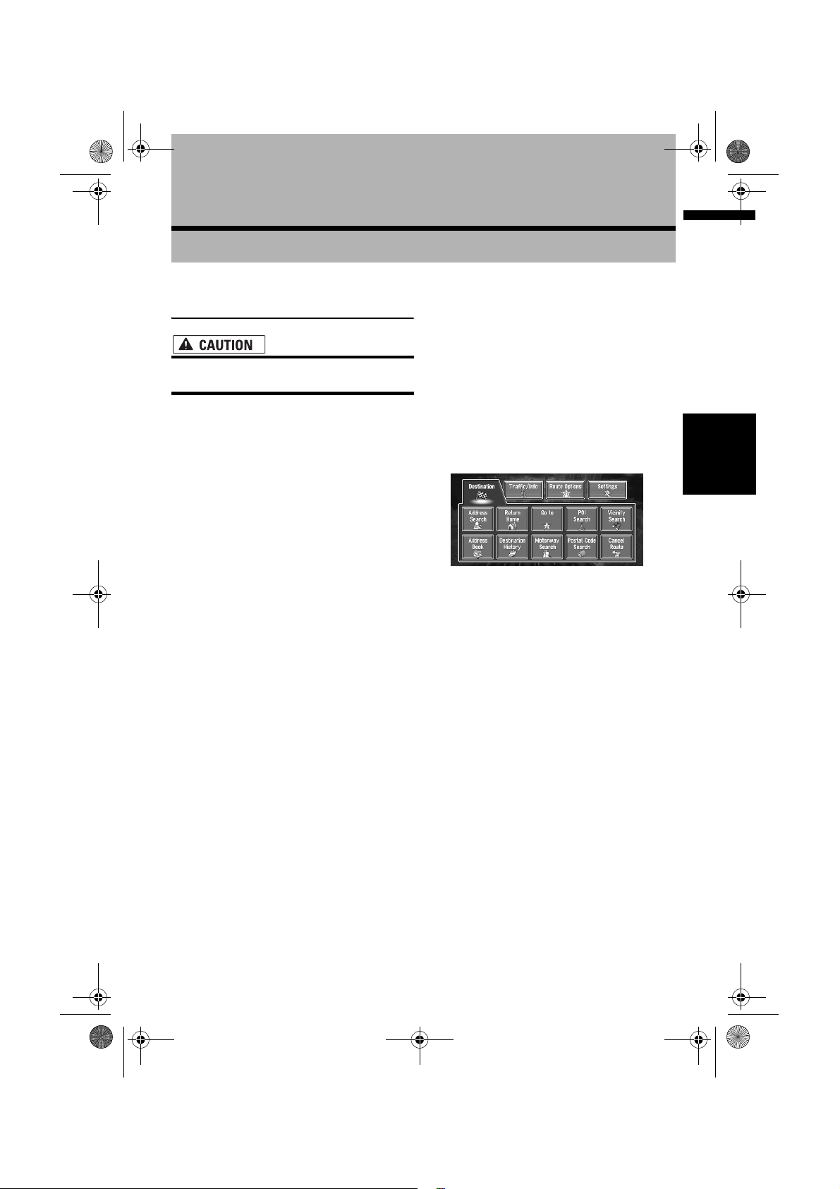
2 Touch “Address Search”.
Selects the method for searching the
destination.
➲ Return Home ➞ Page 32
➲ Go to ➞ Page 32
➲ POI Search ➞ Page 29
➲ Vicinity Search ➞ Page 30
➲ Address Book ➞ Page 32
➲ Destination History ➞ Page 32
➲ Motorway Search ➞ Page 31
➲ Postal Code Search ➞ Page 32
➲ Cancel Route ➞ Page 36
There are two methods of address search: one
involves first specifying the street name and
the other specifying the name of the town or
area first. This description uses the method of
specifying the street name first as an
example.
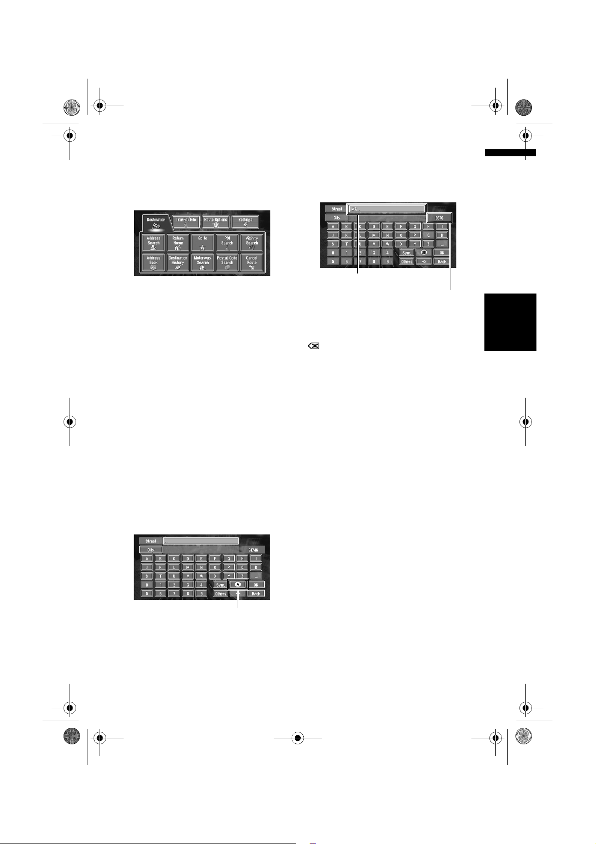
3 Touch “Country key”.
If the destination is in another country, this
changes the country setting.
❒ Once the Country has been selected, you
only have to change country when your
destination is outside of the country you
selected.
Country key
4 Touch the country codes of the
destination country and touch “OK”.
Modifies the country setting and returns you
to the previous display.
5 Input the street name.
Touch the letter you wish to input. If the next
screen is not automatically displayed even
though the street name is entered, try
touching “OK”.
The input text.
The number of applicable candidates.
“City”:
Touch if you wish to first specify the destination
city or area.
:
The input text is deleted letter by letter from the
end of the text. Continuing to press deletes all of
the text.
“Others”:
You can input text with accents and umlauts.
“Sym.”:
You can input text with marks such as “&” and
“+”.
“0-9”:
You can input text with numbers.
“Back”:
Returns you to previous screen.
❒ For example, for “West Higgins Road”, you
can just enter part of the name, such as
“Higgins”.
❒ When entering the characters, the unit will
automatically query the database of all
possible options. If there is only one letter that
could possibly follow your entry, that letter will
automatically be entered.
❒ When touching “Back” on the text input
screen to return to the previous screen, you
may not be able to input text. In such a case,
delete the letters entered in the text box.
❒ The characters contained in “Others” are
treated in the same way as other alphabets
are, upon searching. For example, when you
use any of “A”, “Ä”, “Å”, “Æ”, the result to
come out is the same.
Chapter 1 Basic OperationNAVI/AV
15
Page 18
MAN-CNDV-50MT-EN.book Page 16 Wednesday, May 4, 2005 1:49 PM
Searching your destination after
specifying the name of city or area
You can narrow down the searching candidates
by initially specifying the name of city or area
where your destination is located. Inputting the
name of the city or area then selecting the
destination city or area from the list returns you
to the Street Name input screen. Now input the
street name, select the street from the list, and
proceed to step 9.
• Touching the displays a map of the place
7 Input the destination city or area.
8 Touch the city or area where your
In the selected country, if you touch “City”
Chapter 1Basic Operation NAVI/AV
without entering the name of city or area, you can
check the list of the cities or areas, which you
have searched in the past. (This item cannot be
selected when searching for the first time with
this system or when you have selected a country
that you have never searched before.)
an intersection as your destination. This is
useful when you don’t know the house number
of your destination or cannot input the house
number of the specified street.
you have selected. (Candidate place names
may appear in the list screen.)
If the list screen is displayed, proceed to step
8.
destination is located.
If the area has no house number, a route
calculation starts. Proceed to step 10.
❒ If the selected street is very long and
passes through several cities or areas, the
screen for entering the name of city or area
appears.
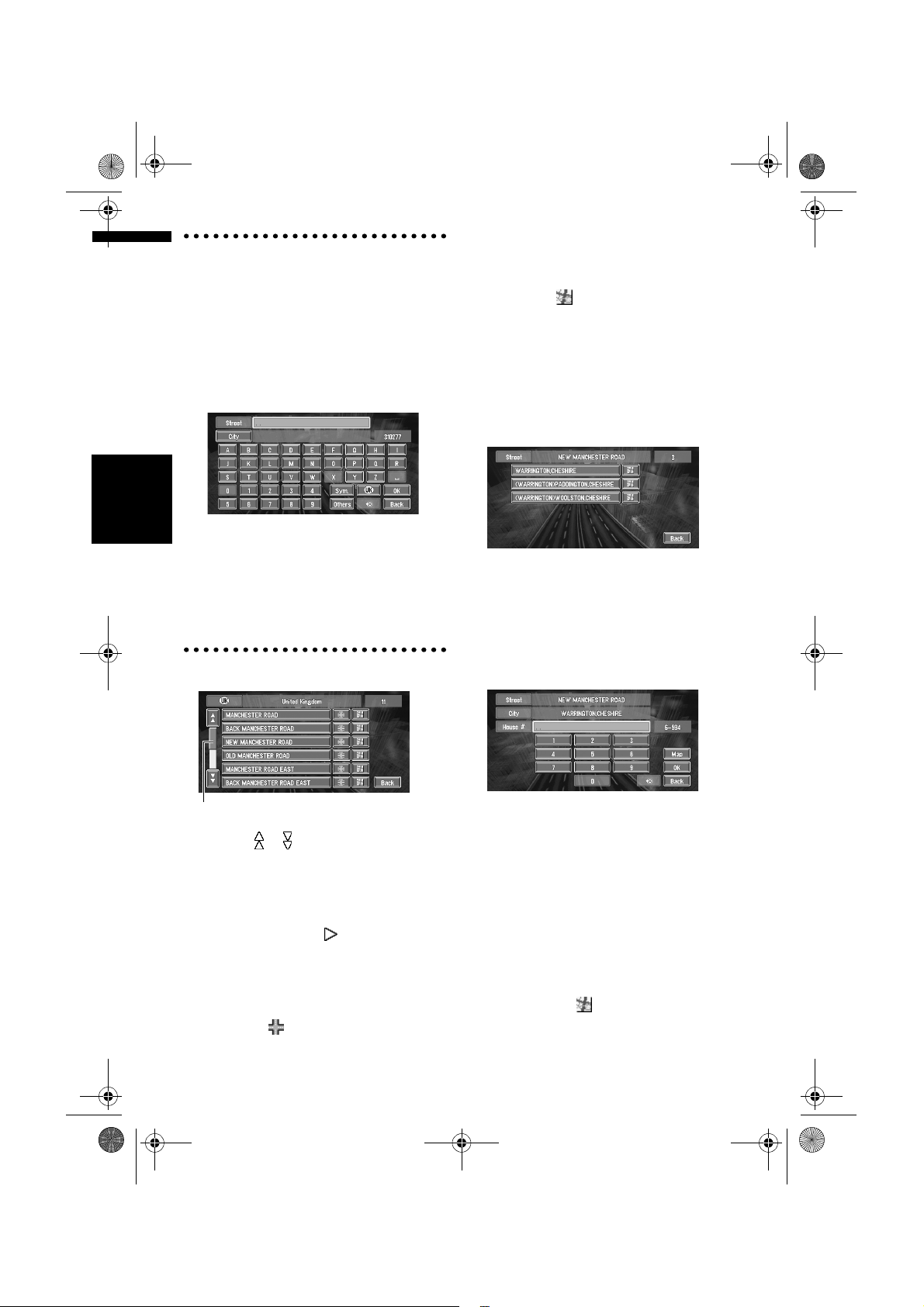
6 Touch the street from the list.
Scroll bar
Touching the or on the scroll bar scrolls you
through the list and allows you to view the
remaining items.
➲ Searching the destination by map ➞ Page 27
In the case of an item that cannot be displayed in
a single line, touching the to the right of the
item allows you to see the whole line.
❒ If only one location is found from the list,
route calculation starts after pressing the
item.
• Touching the specifies the selected street
and streets intersecting it, allowing you to set
16
9 Input the house number and touch “OK”.
On this display, you can select the following
item:
Map:
A map for the input house number is
displayed.
❒ If there are 0 or more than one locations
corresponding to the entered house
number, a list of house number ranges
appears. To start the route calculation,
touch the range within the list you wish to
specify as the destination. You can also
see the destination on the map by
touching the to the right of the list.
➲ Searching the destination by map ➞
Page 27
Page 19
MAN-CNDV-50MT-EN.book Page 17 Wednesday, May 4, 2005 1:49 PM
10Route calculation starts automatically.
Route calculation starts. When the route
calculation is completed, the map of your
surroundings appears. (The route is displayed
in green or light blue.)
❒ If you press the POS button during route
calculation, the calculation is cancelled
and the map display appears.
❒ When performing a destination search
with the route already set, select whether
to regard the specified area as your
destination and search for a new route, or
search for a route via that area.
➲ Adding way points to the route ➞ Page 37
➲ Once searched for, a location is
automatically stored in the “Destination
History” ➞ Page 42
❒ Once the route is entered the map data for
a certain distance is stored in the
navigation unit. Thus, route guidance can
take place even when the map disc is
removed.
➲ Memory navi mode ➞ Page 109
11Drive in accordance with the screen and
voice information.
Your Navigation System gives you the
following information with the timing adjusted
to the speed of your vehicle:
• Distance to the next turning point
• Direction of travel
• Road number of the motorway
• Way point (If this is set)
•Your destination
➲ How to view the screen ➞ Page 22
➲ Searching for another route ➞ Page 36
➲ Cancelling route guidance ➞ Page 36
❒ Touching the allows you to hear the
information again.
❒ If you deviate from the route with the
Guidance set to St.List Mode or Mixed
Mode and enter a street not recorded on the
disc, the screen changes to Map Mode.
When you return to the route, returns to the
original mode and resumes route guidance.
❒ If you stop at a petrol station or a restaurant
during the route guidance, your Navigation
System remembers your destination and
route Information. When you start the engine
and get back on the road, the route guidance
resumes.
❒ If a traffic jam or closure occurs on the set
route ahead, traffic information will appear on
the screen and voice information will be
provided. At that time, select whether to
recalculate for a new route.
➲ Traffic jam information ➞ Page 47
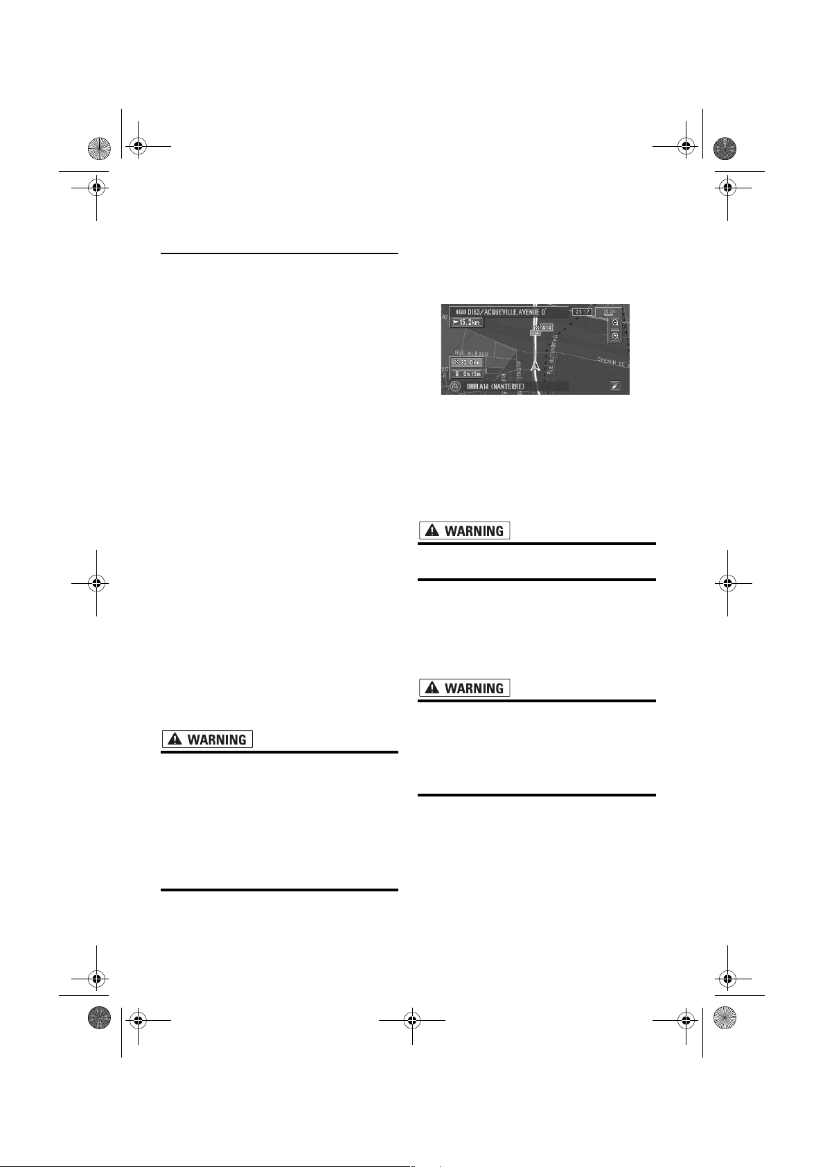
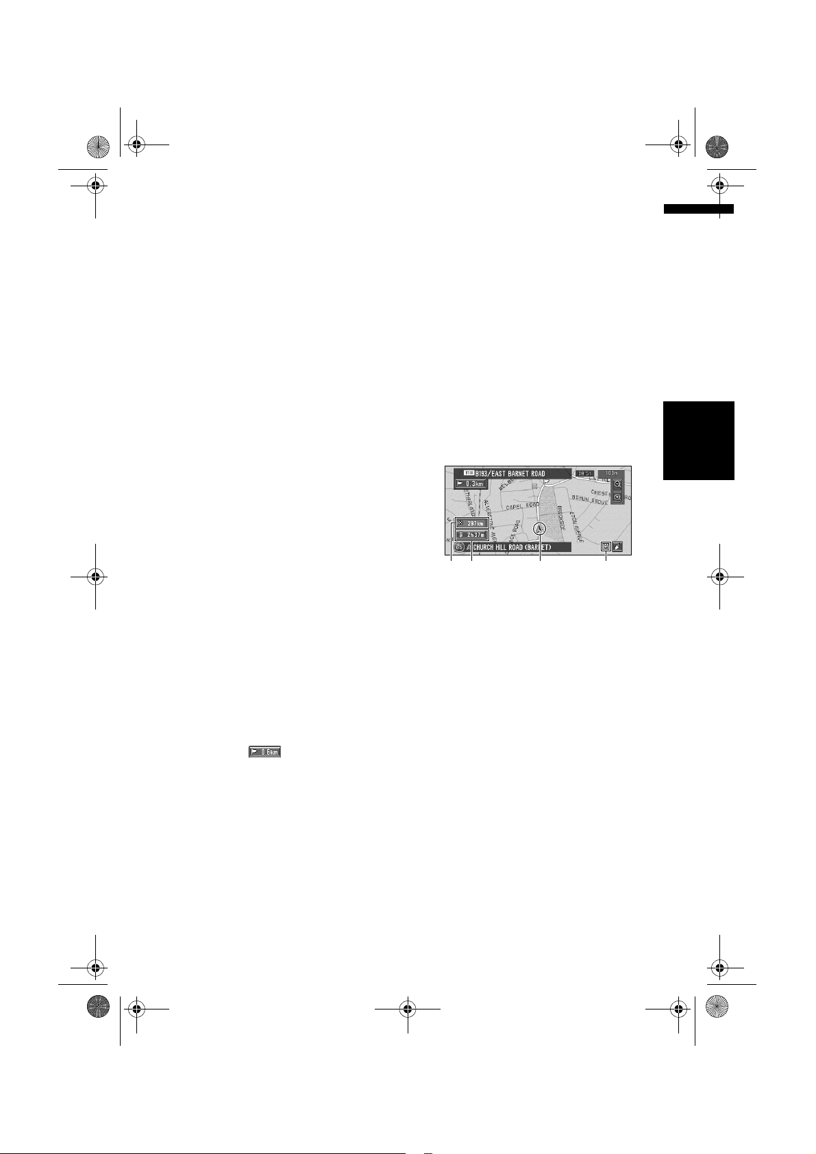
How to view Map Mode screen
This section describes only the items that are
displayed on the Map Mode screen.
➲ Details of the map screen ➞ Page 22
(4)(1)(3)(2)
(1) Current location
(2) Distance to the destination
(3) Estimated time of arrival (or travel time to
your destination)
(4) Memory navi indicator
Flashing green indicates that the data is being
read. When the data reading has completed, this
indicator disappears from the screen.
➲ Memory navi mode ➞ Page 109
Chapter 1 Basic OperationNAVI/AV
17
Page 20
MAN-CNDV-50MT-EN.book Page 18 Wednesday, May 4, 2005 1:49 PM
Memory navi mode
While the map disc is inserted, you can store the
data on the map disc into the memory of the
navigation unit. If the map disc is removed from
the navigation unit after the data is stored,
navigation is performed using the data in the
memory (memory navi mode). In the memory navi
mode, you can play a music CD or DVD-Video on
the navigation unit while navigation is taking
place. The operation is automatically switched to
the memory navi mode when the map disc is
removed from the navigation unit.
Navigation in the memory navi mode
During the memory navi mode, navigation is
performed only using the data read into the
memory. Therefore, some functions are restricted
compared with navigation using the map disc
Chapter 1Basic Operation NAVI/AV
(DVD navi mode). These functions buttons, which
cannot be used in the memory navi mode, are
indicated in light grey. (For details, see page 20.)
If you want to use these functions, please insert
the map disc again. In addition, you may need to
insert the map disc and store new data in the
memory during navigation operation, such as
when the destination is far away. The memory
navi mode uses the following map data to
perform navigation.
How to listen to a CD
You can listen to a CD by removing the map disc
from the navigation unit.
➲ About Memory Navigation ➞ “Memory navi
mode” on page 18. (For details, see page 109.)
1 Press the EJECT button to remove the
map disc.
2 Insert the CD to the disc loading slot.
Memory navi indicator
When new route guidance starts, the route data
from the map disc is read into the memory of the
navigation unit. The status of the memory navi
mode is indicated by the following icons on the
lower right of the map screen.
(green flashes): Reading the data
(green is lit): Operated in memory navi mode
(red is lit): Operated in memory navi mode,
but the distance for guidance is 20 km or less.
❒ Where the distance for navigation guidance is
unknown, the icon flashes red. In that case,
the guidance may suddenly fail. It is therefore
recommended to reinsert the map disc.
When disappears, memory navi mode is
ready. You can now remove the map disc and use
the memory navi mode function.
18
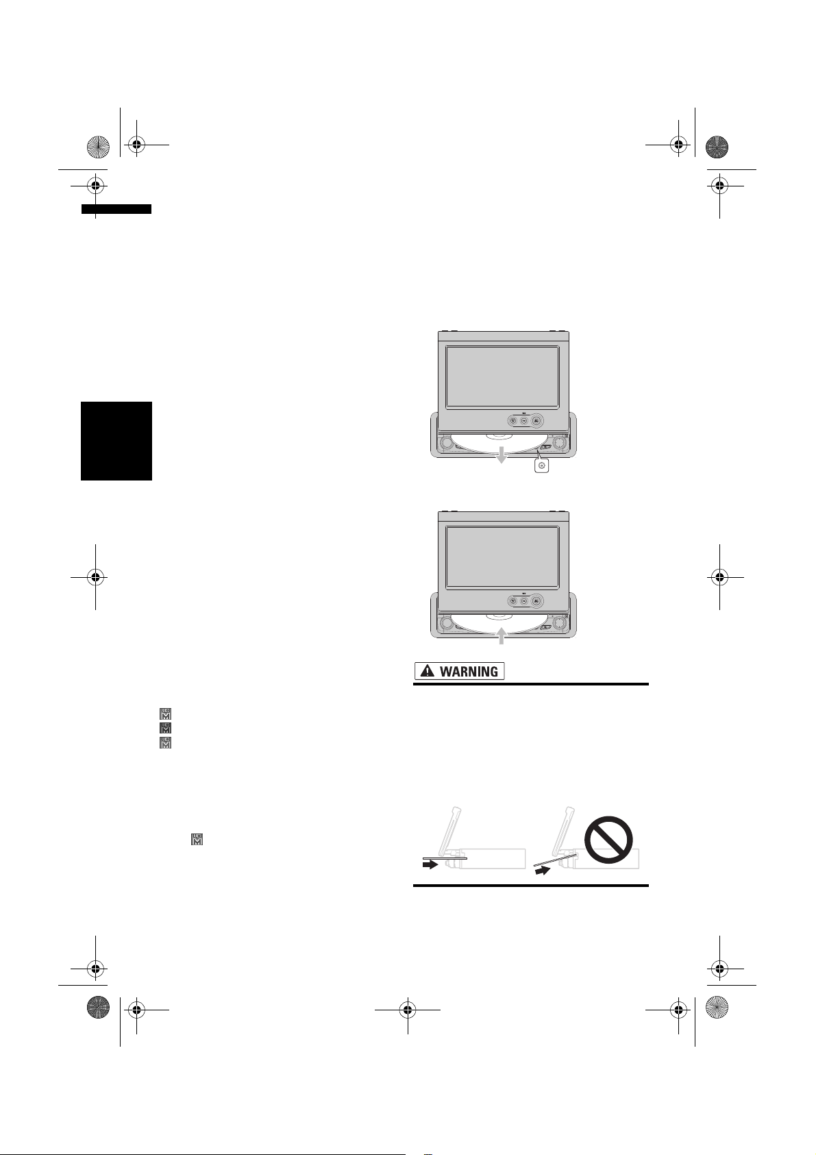
• Be sure to carefully insert the disc
horizontally into the disc loading slot.
When the disc is inserted halfway, the
DVD drive will begin loading
automatically.
• Do not forcibly insert the disc on an angle,
as this indicates that disc is not entering
the disc loading slot and may be damaged.
Page 21
MAN-CNDV-50MT-EN.book Page 19 Wednesday, May 4, 2005 1:49 PM
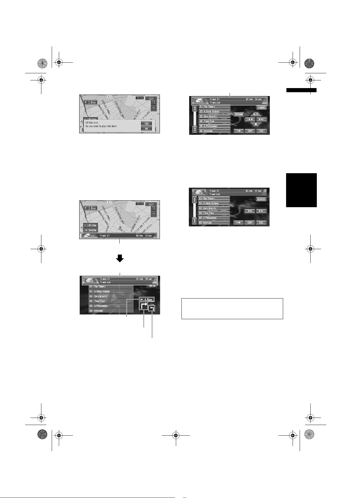
3 Touch “YES”.
The audio CD set in the navigation unit is
played.
❒ DISC AUTO is off in the default setting.
➲ DISC AUTO ➞ Page 96
4 Press the NAVI/AV button to switch the
Audio screen.
Pressing the NAVI/AV button switches
between the navigation map screen and the
audio screen.
Information of Audio
Information of Audio source being played
Information of track being played
You can also skip backward or forward to
another track by moving the joystick left or
right.
You can also operate with 7 or 9 of the
touch keys.
7 To perform fast forward or reverse, touch
➞ then keep touching 1 or 3 .
You can also perform fast reverse/fast forward
by holding the joystick left or right.
Stopping playback
1 Touch (.
When you stop CD playback by touching
that location on the disc is memorised
enabling playback from that point when you
play the disc again.
To play back the disc again, touch ;.
(,
Chapter 1 Basic OperationNAVI/AV
Distance to the guidance point
Current direction of travel
Next direction of travel
5 Touch the screen to display the touch
keys.
The track list and the touch keys are
displayed.
6 Touch the track you want to listen to in
the track list.
The selected track is played.
For details on the functions, which can be used
in the audio source, please see Chapters 6, 7
and 8.
19
Page 22
MAN-CNDV-50MT-EN.book Page 20 Wednesday, May 4, 2005 1:49 PM
Buttons you can use
The status of the buttons appearing on the
screen is indicated by their colour.
Depending on the function the navigation is
performing, you can touch some buttons, while
other buttons are not available.
Blue touch key:
The button is operable.
Dark grey touch key:
The function is not available (e.g., operation is
prohibited while driving).
Light grey touch key:
Chapter 1Basic Operation NAVI/AV
The function is not available during memory navi
mode.
Touching this button activates a message
indicating that the function is not available.
20
Page 23
MAN-CNDV-50MT-EN.book Page 21 Wednesday, May 4, 2005 1:49 PM
Menu and Map Display
Chapter 2
This section describes the basic operations,
including how to display the main menu and how
to use the shortcut menu and the map screen.
How to Use Menu Screens
The basic operation of the navigation is
performed by using menus.
There are two types of menu: the “Main menu”
and the “Shortcut menu”.
❒ The functions that cannot be used during the
memory navi mode are indicated in light grey.
If you want to use such functions, insert the
map disc.
Main menu
You use this menu for basic operation of your
Navigation System.
1 With the map displayed, press the NAVI
MENU button.
2 To change to the menu you want to use,
touch the name of the menu displayed at
the top of the screen.
The main menu is divided into four:
“Destination”, “Traffic/Info”, “Route
Options”, and “Settings”.
3 If you want to return to the map, press the
POS (or NAVI MENU) button.
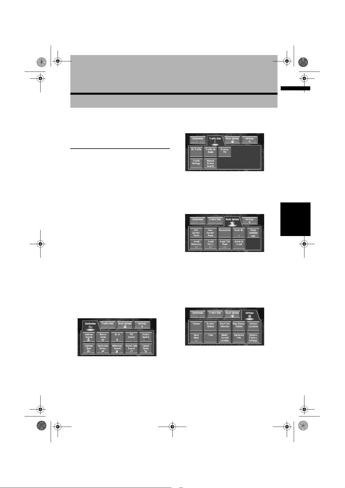
Destination menu
➲ Other search methods ➞ Page 29 to 32
Traffic/Info menu
Used to check traffic information or select the
RDS-TMC station.
➲ All Traffic ➞ Page 46
➲ Traffic On Route ➞ Page 47
Chapter 2 Menu and Map DisplayNAVI
Route Options menu
Used to specify the conditions for setting the
route to the destination.
➲ Setting the Route Options ➞ Page 33
❒ “Edit Current Route”, “View Current
Route”, and “Recalculate” can be used
when the route is set.
Settings menu
Select the destination search method. Also the
route set can be cancelled from this menu.
➲ Specifying the address and searching the
destination ➞ Page 14
➲ Searching the destination by map ➞ Page 27
Set the navigation functions so they can be used
easily.
➲ Settings menu ➞ Chapter 5
21
Page 24
MAN-CNDV-50MT-EN.book Page 22 Wednesday, May 4, 2005 1:49 PM
Shortcut menu
Shortcuts allow you to perform various tasks,
such as route calculation for the location
indicated by the scroll cursor, or registering a
location in the Address Book, faster than using
the Main menu.
❒ The shortcuts displayed onscreen can be
changed. The shortcuts described here are
those that can be selected with the system as
default setting.
➲ Changing a shortcut ➞ Page 57
1 When the map is displayed, briefly touch
any part of the map.
If you continue to touch the map, it will start
scrolling.
➲ Moving the map to view the part you want
to see ➞ Page 26
Chapter 2Menu and Map Display NAVI
: Destination
Displayed when the map is scrolled. Set the
route to the place specified with the scroll
cursor.
➲ Searching the destination by map ➞
Page 27
: Whole Route Overview
Can be selected only during route guidance.
Displays the whole route up to the destination.
: Vicinity Search
You select a location with the scroll cursor.
Nearby POIs (Points Of Interest) will also be
found.
➲ Registering a place ➞ Page 42
➲ Searching the facilities surrounding a
certain place ➞ Page 30
➲ Detour for a specified distance ➞ Page 36
➲ Checking the route ➞ Page 35
➲ Cancelling the route guidance ➞ Page 36
➲ Skipping a way point ➞ Page 37
: Registration
Registering the location indicated by the
scroll cursor to Address Book.
❒ Touching “Registration” and selecting
“Save” allows you to register the location
to Address Book.
➲ Registering a place ➞ Page 42
: Menu Close
Hides the shortcut icon and displays the
screen showing the current position.
How to Use the Map
Most of the information provided by your
Navigation System can be seen on the map. You
need to get to know how the information appears
on the map.
Switching the current position
screen display mode
This section describes how to display the current
position screen and change the map display
mode.
There are four types of map display and two
additional view modes.
• Map Mode
• Driver’s View
• Mixed Mode (during route guidance only)
• St.List Mode (during route guidance only)
• Vehicle Dynamics
• Rear View (Only possible when the
“CAMERA” is set to “ON”)
: Chg.Route
Can be selected only during route guidance.
You can add changes to the route in the route
guidance.
➲ Searching another route ➞ Page 36
22
Page 25
MAN-CNDV-50MT-EN.book Page 23 Wednesday, May 4, 2005 1:49 PM
1 Press the POS button to display a map of
the area around your current position.
2 Press the POS button again.
3 Touch the mode name or press the POS
button to select the mode you want to
display.
❒ If the mode is selected by pressing the
POS button, the screen automatically
switches to the selected map display mode
after 4 seconds.
How to view the map of the
current location
• In Driver’s View, a small gauge with no
scale is depicted, but is not intended to be
used as a speedometer. Use the actual
speedometer of your vehicle to confirm
speed.
Driver’s View
The map from the driver’s viewpoint is shown.
(1)
(2)
(16)
(4)
(12)
(5)(9)
(11) (8)
(17) (19)
(6)
(7)
(10)
(3)
(13)
Mixed Mode
The standard map of your surroundings is
overlaid with the name of the street you will turn
onto next, and 2 arrows: the larger one to the left
indicating the direction of your next maneuver
and how far you are from approaching it, and the
smaller one to the right indicating the direction of
your second to next maneuver and how far you
are from approaching it.
(1)
(2)
(16)
(4)
(12)
(5)(9)
(13)
(11) (8)
(19)(10)
(7)
(18)
(3)(6)
Chapter 2 Menu and Map DisplayNAVI
Map Mode
Displays standard map.
(1)
(2)
(17)
(4)
(12)
(5)(9)
(11) (8)
(3) (19)(6)
(13) (10)
St.List Mode
Displays the name of the street you will next
travel along and an arrow indicating the direction
of travel.
Normal condition
(7)
(18)
(16)
(12)
(2)
(4)
(1)
(5)(9)
(17)
(10)
(11) (8)
(13)
(7)
(14)
(3)
(6)
(19)
23
Page 26
MAN-CNDV-50MT-EN.book Page 24 Wednesday, May 4, 2005 1:49 PM
Vehicle Dynamics Display
Indicates the status of your vehicle.
❒ You can change the items indicated to the
meters on the left and right.
❒ In the Vehicle Dynamics Display mode, the
speedometer display may show a different
speed than your vehicle’s actual
speedometer, because your unit measures
speed in a different way.
➲ Setting the Vehicle Dynamics Display ➞
Page 52
Rear View
Rear view image is displayed on the left-hand
side of the screen, while the map of your
surroundings is indicated on the right.
Chapter 2Menu and Map Display NAVI
(2) (11) (8)
(16)
(3)
(6)
❒ Rear View can be displayed at all times (e.g.
when monitoring an attached trailer, etc.) as a
split screen where map information is partially
displayed. Please beware that in this setting,
camera image is not resized to fit to screen,
and that a portion of what is seen by the
camera is not viewable.
Enlarged map of the intersection
When “Close-up of Junction” in the Settings
menu is “On”, an enlarged map of the junction
appears. If driving on motorway, the special guide
illustration is displayed.
❒ When set to Driver’s View and Vehicle
Dynamics, the system cannot be changed to
an enlarged intersection map.
Display during motorway driving
In select locations of the motorway, lane
(7)
information is available, indicating the
recommended lane to be in to easily maneuver
(14)
the next guidance.
(20)
(14)(15)
❒ If the “CAMERA” is set to “OFF”, the rear
view image is not displayed. Please set it to
“ON”.
➲ Camera setting ➞ Page 96
❒ When using a camera set to turn OFF/ON in
conjunction with the reversing signal, no
camera images will be displayed in rear view
mode while you are moving forward.
➲ If the camera is set always ON, it can display
images in rear view mode when the vehicle is
moving forward. In that case, you should ask
the camera maker or dealer whether the
camera’s functions or longevity would be
affected.
24
When driving on the motorway, motorway exit
numbers and motorway signs may be displayed
when in the vicinity of interchanges and exits.
(21) (22)
Page 27
MAN-CNDV-50MT-EN.book Page 25 Wednesday, May 4, 2005 1:49 PM
City Map
In certain metropolitan city areas, a more
detailed “City Map” is available at the 50 m (0.05
mi) map scale or lower.
(1)
(2)
(4)
(12)
(5)(9)
(11) (8)
(7)
(3) (6)
❒ Detailed city map is not displayed during the
memory navi mode.
❒ Except when on a motorway, if you are driving
by an area where a City Map is available at the
100 m (0.1 mi) map scale, a message appears
informing you that you have entered a city
map area.
Display items
Guidance point*
The next guidance point (next turning point, etc.)
is shown by a yellow flag.
Destination*
The chequered flag indicates your destination.
(1) Name of the next street to be used*
(2) Distance to the guidance point*
Touch to access the next information.
(3) Current location
The current location of your vehicle. The tip of the
triangular mark indicates your heading and the
display moves automatically as you drive.
(4) Distance to the destination (or distance to
way point)*
If way points are set, the display changes with
each touch. When two or more way points are
set, the distance to the destination and the
distance to the next way point are switched.
(5) Name of the street your vehicle is
travelling along (or City Name, etc.)
(6) Compass
The red arrow indicates north. If the scale of the
onscreen map is less than 50 km (25 mi),
touching the map changes the direction it is
displayed in (north up/heading up). When the
scale of the map is not less than 50 km (25 mi), it
is fixed to “north up”.
Heading up
The map display always shows the vehicle’s
direction as proceeding toward the top of the
screen.
North up
The map display always has north at the top of
the screen.
(7) Zoom in/Zoom out
Touch to change the map’s scale.
➲ Changing the map’s scale ➞ Page 26
(8) Map scale
The scale of the map is indicated by distance.
Except for on the Vehicle Dynamics Display,
the scale of the map is displayed at the top right
of the screen.
➲ Changing the map’s scale ➞ Page 26
(9) VOICE icon
Touch to change to voice recognition mode.
❒ This is displayed only when the microphone
for voice recognition is connected.
➲ The voice operation of the navigation system
➞ Chapter 9
(10) TMC icon
When a route has been calculated, touch to
check whether there is any traffic jam or closure
information on your route. When no route has
been calculated, touch to display the traffic list.
(11) Current time
(12) Estimated time of arrival (or travel time
to your destination)*
The display changes with each touch.
The estimated time of arrival is automatically
calculated from the Average Speed set and the
actual average speed.
➲ How to set average speed ➞ Page 56
(13) Tracking mark
The tracking mark shows the route your vehicle
has travelled.
➲ Select the tracking setting ➞ Page 57
Chapter 2 Menu and Map DisplayNAVI
25
Page 28
MAN-CNDV-50MT-EN.book Page 26 Wednesday, May 4, 2005 1:49 PM
(14) Map of your surroundings (Side map)
Touching on the map briefly shows the shortcut
menu, while touching longer changes the map to
Scroll mode.
➲ Moving the map to the location you want to
see ➞ Page 26
(15) Distance to an intersection*
Displayed on the enlarged intersection map. The
green bar gets shorter as your vehicle
approaches an intersection.
(16) Next direction of travel*
When you approach an intersection, it appears
green. The screen displays the distance to the
next guidance point, and the next guidance point
after that.
(17) Area to Avoid*
➲ About detour area ➞ Page 45
(18) Direction line
The direction towards the location set in (4) is
indicated with a straight line.
(19) Memory navi indicator
Chapter 2Menu and Map Display NAVI
➲ About memory navi indicator ➞ Page 110
(20) Lane information
Lane information is displayed the first time voice
guidance is carried out. When the guidance
screen is displayed near an interchange or exit,
the lane information disappear.
(21) Motorway signs
These show the road number. and give
directional information.
(22) Motorway exit information
Displays the motorway exit.
❒ Information with the mark (*) appears only
when the route is set.
❒ Depending on the conditions and settings,
some items may not be displayed.
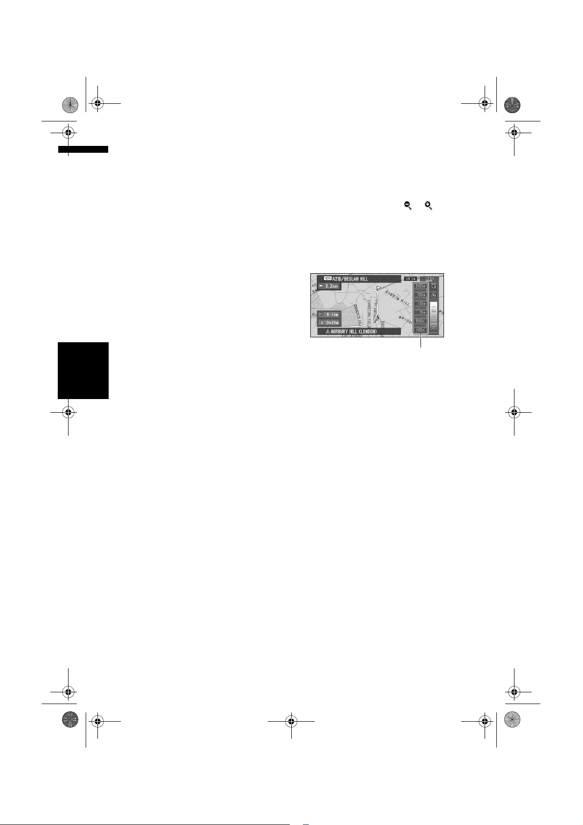
Changing the scale of the map
Touching the “Zoom in/Zoom out” key displayed
on the upper right of the screen displays the
scale gauge and “Direct scale” key. Directly
touching the “Direct scale” key changes the map
to the selected scale. Touching or above
the scale gauge allows you to specify the scale in
greater detail within a range of 25 metres - 500
kilometres (25 yards - 250 miles).
❒ Selection of the scales is limited during the
memory navi mode.
Direct scale key
❒ The icon of a registered location and the
traffic information icons are displayed when
the map scale is 20 km (10 miles) or lower.
❒ POI icons and the traffic jam lines are
displayed when the map scale is 1 km (0.75
miles) or lower.
❒ The Direct scale key may not appear
depending on the map display mode.
Moving the map to the location
you want to see
If you touch the display briefly, the shortcut menu
appears.
Touching anywhere on the map for at least 2
seconds changes the map to Scroll mode and the
map begins scrolling in the direction you
touched. The scrolling stops when you release
your finger from the screen. At this time, the
scroll cursor appears at the centre of the screen.
Also a line connecting between the current
location and scroll cursor appears.
Pressing the POS button returns you to the map
of your surroundings.
❒ Touch the area close to the centre of the
screen to scroll slowly; touch near the sides of
the screen to scroll through quickly.
26
Page 29
MAN-CNDV-50MT-EN.book Page 27 Wednesday, May 4, 2005 1:49 PM
(3) (2)
(1) Scroll location
The position of scroll cursor shows the location
selected on the current map.
❒ When the scale is 200 m (0.25 mi) or lower,
the road appears light blue in the vicinity of
the scroll cursor.
(2) Direction line
The direction towards the scroll cursor is
indicated with a straight line.
(3) Distance from the current location
Shows the distance in a straight line between the
location indicated by the scroll cursor and your
current location.
(4) The street name, city name, area name
and other information for this place.
(The information displayed varies according to
the scale.)
Touching the on the right displays hidden text.
➲ Displaying information on the specified
location ➞ Page 27
(5) Shortcut menu
➲ How to view shortcut menu ➞ Page 22
(1)
(5)
(4)
Viewing the information of a specified
location
An icon appears at registered places (home
location, specific places, address book entries)
and places where there is a POI icon or traffic
information icon. Place the scroll cursor over the
icon to view detailed information.
1 Scroll the map and move the scroll cursor
to the icon you want to view.
2 Touch .
Information for a specified location appears.
The information shown varies according to
the location. (There may be no information for
that location.)
➲ Registering places ➞ Page 41
➲ Displaying facilities (POI) mark on the map
➞ Page 31
➲ Using traffic information ➞ Page 46
3 Touch “Back”.
You are returned to the previous display.
❒ In the memory navi mode, you can only see
detailed information for registered points
(when available).
Finding a destination on the map
If you search the location you want to visit by
scrolling the map, and touch in the Shortcut
menu, you can specify your destination on the
map.
1 Press the POS button to access the map
screen.
2 Touch the map for at least 2 seconds.
The map display changes to Scroll mode.
3 Scroll the map and move the scroll cursor
to the place you want to make your
destination.
➲ Moving the map to view the part you want
to see ➞ Page 26
Chapter 2 Menu and Map DisplayNAVI
4 Touch .
❒ If you press the POS button during route
calculation, the calculation is cancelled and
the map display appears.
27
Page 30
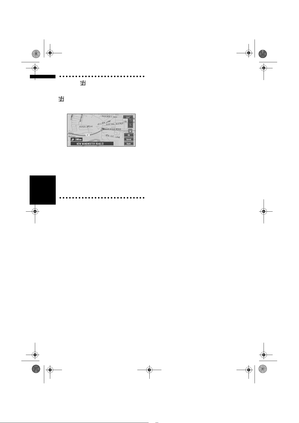
MAN-CNDV-50MT-EN.book Page 28 Wednesday, May 4, 2005 1:49 PM
When the appears on the right of
the list
You can also set a destination by touching the
to the right of the list. Touch “OK” to confirm.
The location pointed by the scroll cursor will be
set as a destination.
Alternative option:
Scroll:
The map display changes to the map the
Shortcut menu.
If you touch anywhere on the map, the map
display changes to Scroll mode.
➲ Shortcut menu ➞ Page 22
Chapter 2Menu and Map Display NAVI
28
Page 31
MAN-CNDV-50MT-EN.book Page 29 Wednesday, May 4, 2005 1:49 PM
Setting a Route to Your Destination
Searching for Points of Interest
• For safety reasons, these route-setting
functions are not available while your
vehicle is in motion. To enable these
functions, you must stop in a safe place
and put on the handbrake before setting
your route.
❒ Some information on traffic regulations by
days or time depends on the time when the
route calculation is performed. Thus, the
information may not correspond with a
certain traffic regulation when your vehicle
actually passes the location. Also, the
information on the traffic regulations provided
will be for a passenger vehicle, and not for a
truck/lorry or other delivery vehicles. Always
follow the actual traffic regulations when
driving.
❒ If you press the POS button during route
calculation, the calculation is cancelled and
the map display appears.
❒ When the map disc is inserted, the reroute is
done by force. (This rerouting cannot be
cancelled.)
Finding Your Destination by
Selecting the Type of Facility
(POI)
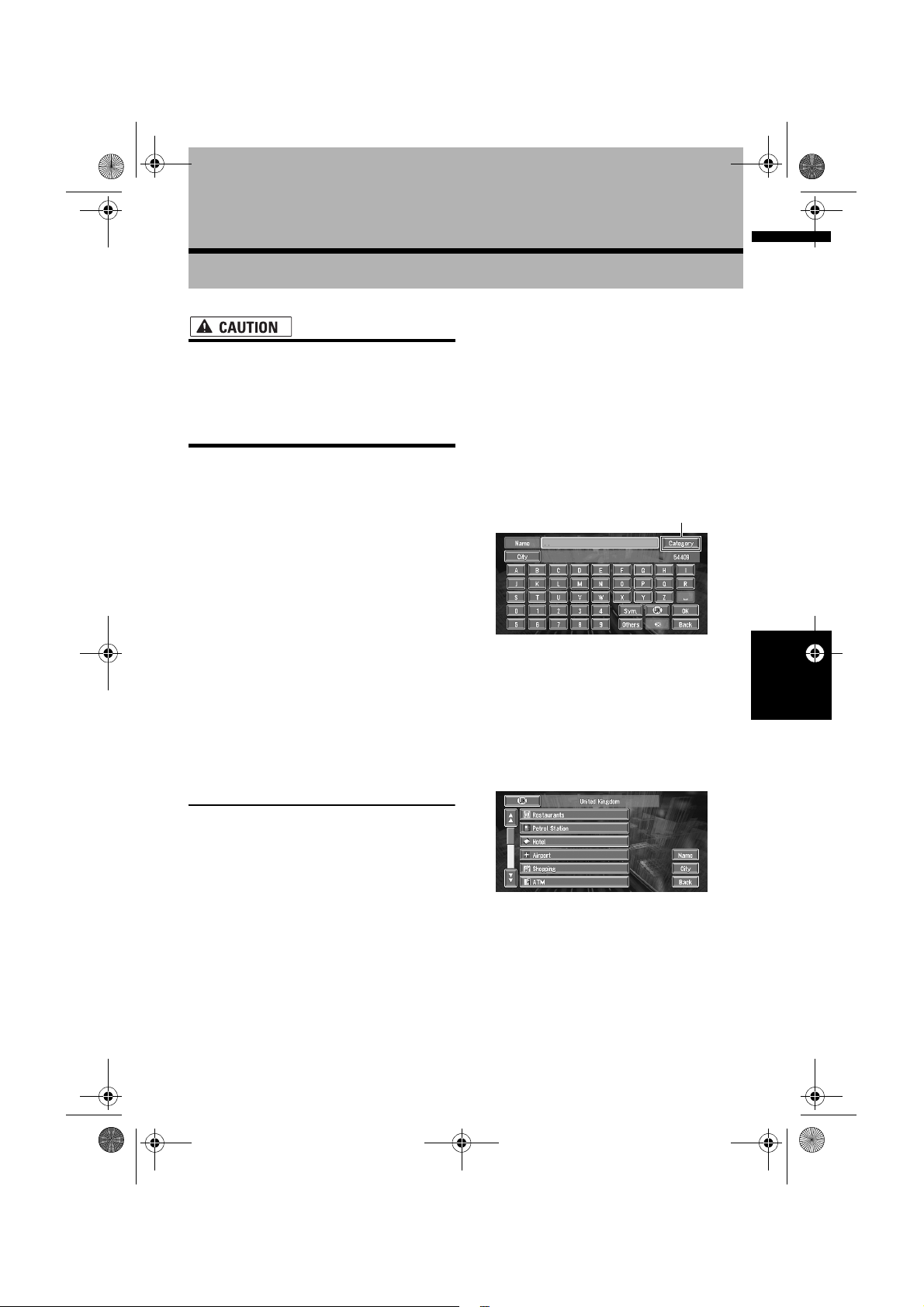
1 Touch “Destination” in the Main menu,
2 Touch the country key of the destination
3 Touch “Category”.
4 Touch the desired category.
Chapter 3
and then touch “POI Search”.
country and touch “OK”.
➲ Selecting the country where you want to
search ➞ Page 15
Category
Chapter 3 Setting a Route to Your DestinationNAVI
“Name”:
Touch if you wish to first specify the POI
Name.
“City”:
Touch if you wish to first specify the
destination city or area.
POI’s are divided into several categories.
Information about various facilities (Points Of
Interest - POI), such as petrol stations,
amusement parks or restaurants is available. By
selecting the category (or entering the POI
Name), you can search for a Point Of Interest.
❒ You can also narrow down the search range
by initially specifying the name of the city or
area where your destination is located.
If the category is not sub-divided into more
detailed categories, the list will not be
displayed. Proceed to Step 6.
29
Page 32

MAN-CNDV-50MT-EN.book Page 30 Wednesday, May 4, 2005 1:49 PM
5 Touch the subcategory.
6 Input the name of the POI.
If the list does not automatically appear when
the name of the POI has been entered, try
touching “OK”.
“City”:
First, touch to specify the destination city or
area.
❒ If less than six POIs in a subcategory are
registered, the screen for inputting the POI
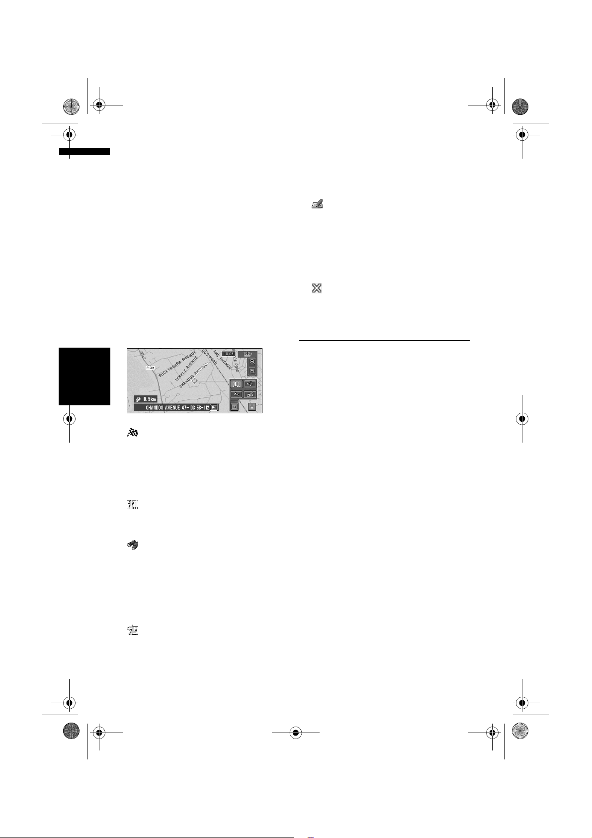
name is not displayed. Please proceed to
Step 7.
7 Touch POI for your destination.
❒ Touching the displays a map of the
surroundings of the selected POI.
➲ Searching the destination by map ➞
Page 27
❒ If the selected POI is the name of a chain
of outlets and consequently the same store
name applies to different locations (the
number of outlets appears next to the
chain’s name), touch the name of the POI
to display a list of those POIs and touch
the particular POI that is your destination.
Finding a POI in your
surroundings
Chapter 3Setting a Route to Your Destination NAVI
You can search for Points Of Interest in your
surroundings on the map. Use it to find a POI to
visit during a journey.
1 Touch “Destination” in the Main menu,
and then touch “Vicinity Search”.
The list of Points Of Interest categories
appears.
2 Touch the desired category.
The selected category will have a red tick
mark.
OK:
Starts searching
Back:
Returns to the previous screen
Set:
Display the screen for registering POI
shortcut
➲ Register POI shortcut ➞ Page 38
❒ If you want to search with more detailed
categories, touch . When the
subcategory list appears, touch the item
and touch “Back”. When only a few types
of the detailed categories are selected,
blue tick marks will appear.
❒ The bottom icon is for shortcuts to your
favourite categories. Touching the
shortcuts icon displays a list of the
facilities in a category.
❒ You can select the detail category for up to
100 items.
3 Touch POI.
Names of POIs and their distance from your
current location appear. They are listed in
nearest-to-furthest order. To the left of each
item is an icon indicating the category.
Distance to the facility
❒ When you touch , the POIs around the
specified location are shown on a map.
➲ Searching the destination by map ➞
Page 27
❒ Searching range is approximately 16 km
(10 miles) square from the current
location.
Searching the facilities around
the scroll cursor
1 Scroll the map and move the scroll cursor
to the place you want to search POI.
2 Touch .
See Step 2 of “Finding a POI in your
surroundings” for the following operations.
➲ Finding a POI in your surroundings ➞
Page 30
❒ This can be used when setting the Vicinity
Search icon to display as a shortcut on the
map screen.
➲ Changing Shortcut ➞ Page 57
30
Page 33

MAN-CNDV-50MT-EN.book Page 31 Wednesday, May 4, 2005 1:49 PM
❒ The distance indicated in the search result
is the distance from the scroll cursor to the
facility.
❒ The bottom icon is for shortcuts to your
favourite categories. Touching the
shortcuts icon displays a list of the
facilities in a category.
❒ “Vicinity Search” in the Main menu
searches your surroundings. On the other
hand, in the case of in the Shortcut
menu (➞ Page 22), the area around the
scroll cursor will be searched.
Displaying certain POI on the
map
Selected Points Of Interest (POI) in a certain
category can be shown on the map, and you can
check the location on the display while driving.
❒ This can be used when setting the overlay POI
icon to display as a shortcut on the map
screen.
➲ Changing Shortcut ➞ Page 57
1 Touch any part of the map screen.
The Shortcut menu appears.
2 Touch .
The list of POI categories appears.
3 Touch the category you want to display.
The selected item is marked. If you want to
select other categories, repeat this step.
❒ If you want to search with more detailed
categories, touch . When the
subcategory list appears, touch the item
you want to display and touch “Back”.
❒ The bottom icon is for shortcuts to your
favourite categories. Touching the
shortcuts icon displays a list of the
facilities in a category.
❒ You can select the detail category up to
100 items.
❒ When some sub-categories are selected,
the corresponding category is marked
blue. When all the sub-categories within a
category are selected, that category is
marked red.
Setting an Entrance or Exit of a
Motorway as Your Destination
You can set the entrance or exit of a motorway as
your destination.
1 Touch “Destination” in the Main menu,
and then touch “Motorway Search”.
The display for entering the name of the
motorway appears.
2 Touch the country key of the destination
country and touch “OK”.
3 Enter the name of the motorway and
touch “OK”.
The list of motorways matching the name
appears.
4 Touch the motorway.
The display for selecting your destination to
the entrance or to the exit of the motorway
appears.
5 Touch “Entrance” or “Exit”.
The list of entrances to, or exits from, the
selected motorway appears.
6 Touch your destination.
❒ You can also see the destination by
touching the on the right of the list.
➲ Searching the destination by map ➞
Page 27
Chapter 3 Setting a Route to Your DestinationNAVI
4 Touch “Back”.
POI’s in the selected category appear on the
map.
➲ Searching the destination by map ➞
Page 27
➲ Viewing the information of POI ➞ Page 27
31
Page 34

MAN-CNDV-50MT-EN.book Page 32 Wednesday, May 4, 2005 1:49 PM
Finding Your Destination by
Specifying the Post Code
If you know the post code of your destination, you
can use it to find your destination.
1 Touch “Destination” in the Main menu,
then touch “Postal Code Search”.
The post code input screen appears.
2 Touch the country key of the destination
country and touch “OK”.
3 Input the post code.
A list of cities with the specified postal code is
shown.
British post code:
If you input a British postal code, the map
with the cursor on the selected position is
shown. When you touch “OK”, a route search
begins.
Netherlands post code:
• If you input a complete post code, a list of
street is shown.
• If you input a partial post code, and touch
“OK”, a list of cities is shown.
4 Search for your destination in accordance
with the procedures after Step 5 in
Chapter 1 “Basic Operation”.
Chapter 3Setting a Route to Your Destination NAVI
❒ Depending on the destination, the search may
start directly.
❒ Not all post codes are recorded on the disc.
Thus, you may not be able to find the location
corresponding to the post code you enter.
Route Calculation to Your Home
Location or to Your Favourite
Location
If your home location is registered, the route
home can be calculated by a single touch of the
touch key from the Main menu. Also, you can
register one location, such as your workplace, as
your favourite location, and the route is
calculated in a similar way.
1 Touch “Destination” in the Main menu,
and then touch “Return Home” or “Go to”.
➲ “Registering your home and your favourite
location” ➞ Page 41
Selecting Destination from the
Destination History and Address
Book
Any place that has been searched before is
stored in the “Destination History”. Places that
you have registered manually, such as your
home, are stored in the “Address Book”. Simply
select the place you want to go to from the list
and a route to that place will be calculated.
1 Touch “Destination” in the Main menu,
and then touch “Address Book” or
“Destination History”.
2 Touch your destination name.
32
Route calculation starts.
➲ For information on the Address Book ➞
Chapter 4
➲ For information on the Destination
History ➞ Chapter 4
❒ You can also see the destination by
touching the on the right of the list.
➲ Searching the destination by map ➞
Page 27
Page 35

MAN-CNDV-50MT-EN.book Page 33 Wednesday, May 4, 2005 1:49 PM
Modifying the Route Calculation
Conditions
You can change the route calculation conditions
using the Route Options menu. The following
description features an example of changing the
number of the route to be searched.
1 Touch “Route Options” in the Main menu.
The Route Options menu appears.
2 Touch “Route No.”.
The content currently set appears under the
name of the item. Each time you touch the
item, the setting changes. Repeatedly touch
the item until the value you want to set
appears.
Items that users can change
This section describes the details of the setting
for each menu. Settings marked with an asterisk
(*) show that they are default or factory settings.
Edit Current Route
➲ “Reroute” or “XX km/mile detour” ➞ Page 36
➲ “Cancel Route” ➞ Page 36
➲ “Route Scroll” ➞ Page 35 (Step 3 and 4)
➲ “Route Profile” ➞ Page 35 (Step 3 and 4)
➲ “Skip way point” ➞ Page 37
View Current Route
➲ View Current Route ➞ Page 36
Recalculate
➲ “Reroute” or “XX km/mile detour” ➞ Page 36
➲ “Cancel Route” ➞ Page 36
➲ “Route Scroll” ➞ Page 35 (Step 3 and 4)
➲ “Route Profile” ➞ Page 35 (Step 3 and 4)
➲ “Skip way point” ➞ Page 37
Automatically searches the route to the
destination again.
❒ “Recalculate” is displayed only when the
route is set.
Route No.
This setting controls whether the system should
calculate only one route, or several routes.
1*:
Only one route judged as being optimum by your
Navigation System is calculated.
Multiple:
Several route options are calculated (maximum 6
routes).
Route Condition
This setting controls whether the route be
calculated with taking into account the time or
the distance.
Fast*:
Calculate a route with the shortest travel time to
your destination as a priority.
Short:
Calculate a route with the shortest distance to
your destination as a priority.
Avoid Motorway
This setting controls whether or not motorways
may be included in the road calculation. (A route
using motorway may be calculated in some
cases, such as when setting your destination far
away.)
On:
Calculate a route that avoids motorways.
Off*:
Calculate a route that may include motorways.
Avoid Ferry
This setting controls whether or not ferry
crossings should be taken into account.
On:
Calculate a route that avoids ferries.
Off*:
Calculate a route that may include ferries.
❒ The system may calculate a route that
includes ferries even if “On” is selected.
Chapter 3 Setting a Route to Your DestinationNAVI
33
Page 36

MAN-CNDV-50MT-EN.book Page 34 Wednesday, May 4, 2005 1:49 PM
Avoid Toll Road
This setting controls whether or not toll roads
(including toll areas) should be taken into
account.
On:
Calculate a route that avoids toll roads (including
toll areas).
Off*:
Calculate a route that may include toll roads
(including toll areas).
❒ The system may calculate a route that
includes toll road even if “On” is selected.
Areas to Avoid
➲ About Areas to Avoid ➞ Page 45
Perform the route calculation of
the several route options, and
select one
You can get route calculations of several route
options. After route options are calculated, select
the one you want.
1 Set the “Route No.” to “Multiple”.
➲ Changing the search conditions ➞
Page 33
2 Search your destination and set the route.
Chapter 3Setting a Route to Your Destination NAVI
Calculated routes are shown in different
colours (from two to six routes).
3 Touch “Next” to change the displayed
route.
Displaying impracticability of fulfilling the
conditions by icon.
• Pass through Area to Avoid
• Use toll road against the setting “Avoid
Toll Road” is “On”.
• Use Ferry against the setting “Avoid
Ferry” is “On”.
(2) Distance to your destination
(3) Travel time to your destination
❒ The “Avoid Motorway” setting may not be
reflected, depending on the distance to the
destination.
❒ You can see other places while displaying
a candidate route by scrolling the map.
Touching “Next” moves the next candidate
route to the centre and indicates the map.
4 Touch “Information” to check the
information on the selected route.
You can also check details of the roads along
the selected route. (If you touch “Back”, you
can return to the previous display.)
➲ “Route Scroll” ➞ Page 35 (Step 3 and 4)
➲ “Route Profile” ➞ Page 35 (Step 3 and 4)
❒ After the route is calculated, it may take
some time until the detailed route
information (Route Profile) can be
confirmed.
5 Touch “OK”.
The route you selected is accepted, and the
map of your surroundings appears. When you
start driving, the route guidance begins.
❒ If the above operations are not performed
within 30 seconds after the route
calculation is completed and you have
already started your vehicle, the route
selected at the time is automatically
chosen.
(1) (3) (2)
The following information is displayed on this
screen:
(1) Route calculation condition
Displaying the conditions set by the Route
Options menu by icon.
•Use/avoid motorway
•Use/avoid toll road
• Use/avoid ferry
34
Page 37

MAN-CNDV-50MT-EN.book Page 35 Wednesday, May 4, 2005 1:49 PM
Checking the Set Route
You can check information about the route
between your current location and your
destination.
You can select two methods: checking the
passing streets with a list; and checking the
shape of the route by scrolling the map along the
route.
Scroll Cursor
Current Route
Checking the set route with the
map
1 Touch the map screen.
The Shortcut menu appears.
2 Touch .
The Route/Detour menu appears.
3 Touch “Route Scroll”.
The screen to select the point to start scrolling
appears.
4 Touch the point to start scrolling.
(3)(1) (2)
You can select the following items:
(1) Starting Point
(2) Way Point (If this is set)
(3) Destination
❒ If you have selected “Way Point”, a list of
the way points on the route is displayed.
Touch the place you want to start scrolling
from and proceed to step 5.
You can select the following items:
Map:
The scroll screen is displayed.
➲ Searching the destination by map ➞
Page 27
6 Touch “Back”.
You can return to the previous display.
Checking the set route with text
This function is not available if your vehicle has
deviated from the set route.
❒ When Route Profile is selected during the
memory navi mode, the information up to the
location in which the route is in the memory is
displayed.
1 Touch the map screen.
The Shortcut menu appears.
2 Touch .
The Route/Detour menu appears.
3 Touch “Route Profile”.
4 Check the contents on the display.
As necessary, scroll the list.
Name of the streets you are driving through
Chapter 3 Setting a Route to Your DestinationNAVI
5 Touch or to scroll the map.
To continue scrolling after you release your
finger, touch and hold or .
If necessary, the scale of the map can be
changed.
Driving distance
5 Touch “Back”.
You can return to the previous display.
35
Page 38

MAN-CNDV-50MT-EN.book Page 36 Wednesday, May 4, 2005 1:49 PM
❒ When a long distance route is calculated,
your Navigation System may not be able to
list all the roads. (In this case, the
remaining roads will be shown in the list
as you drive on.)
Checking the set route from the
Route Options menu
You can also check the information about the set
route from the Route Options menu.
❒ When Profile is selected during the memory
navi mode, the information up to the location
in which the route is in the memory is
displayed.
1 After touching “Route Options” in the
main menu, touch “View Current Route”.
❒ “View Current Route” is displayed only
when the route is set.
2 Touch “Scroll”, “Profile” or “Overview”.
Overview:
A map of the whole route up to the destination
is displayed.
➲ “Profile” ➞ Page 35 (Step 3 and 4)
➲ “Scroll” ➞ Page 35 (Step 3 and 4)
3 Touch “Back”.
Chapter 3Setting a Route to Your Destination NAVI
You can return to the previous display.
3 Touch “Reroute” or the distance from the
list.
After the route is calculated, the map screen
shows your surroundings and route guidance
is resumed.
On this display, you can select the following
items:
Reroute:
The route from the current position to your
destination is recalculated.
The distance of the detour
(1-50 km/mile):
Searches detours of a specified distance in
the route ahead of your current position.
➲ For details of switching the display between
“km” and “mile”(miles) see “KM Mile
Setting” ➞ Page 56
Cancelling the Route Guidance
If you no longer need to travel to your destination
or if you want to change your destination, follow
the steps below to cancel the route guidance.
Recalculating the Route to Your
Destination
You can set the length of the area, and avoid just
that area, or you can even search a new route
from the current location to your destination. (On
the map screen during route guidance, try the
following operations.)
1 Touch the map screen.
The Shortcut menu appears.
2 Touch .
The Route/Detour menu appears.
36
1 Touch “Destination” in the Main menu,
then touch “Cancel Route”.
The message confirming whether to cancel
the current route appears.
2 Touch “Yes (all)”.
The current route is deleted, and a map of
your surroundings reappears.
On this screen, you can also select the
following items:
Yes (one):
Route is recalculated by cancelling the
selected way point.
Page 39

MAN-CNDV-50MT-EN.book Page 37 Wednesday, May 4, 2005 1:49 PM
➲ Deleting a way point from the route ➞
Page 38
No:
Returns to the previous display without
deleting the route.
❒ You can also cancel the route using the
Chg.Route in the shortcut menu.
Adding Way Points to the
Current Route
You can select way points (locations you want to
visit on the way to your destination) and you can
recalculate the route to pass through these
locations.
Adding a way point
You can add up to five way points. This is
achieved as follows:
1 Specify the location you want to visit.
Specify a way point in the same way as
specifying a destination.
At completion of the location search, a
message is displayed asking whether or not to
set that specified location as the destination,
or as a pass-through location.
2 Touch “Way Point”.
3 Confirm the contents of the list, and touch
“Done”.
Add:
Switch the display to search for points. When
you display the map of a certain point after
searching for it, you can touch “OK” to add
that point to the way points. (You can add up
to five way points in total.)
Delete:
You can delete way points from the list.
Sort:
Touch to display a screen listing the way
points.
Automatic:
You can sort the destination and way points
automatically. The system will show the
nearest way point (distance in a straight line)
from the current location as way point 1, and
sort the other points (including your
destination) in order of distance from the one
before.
Original:
Returns to the original order.
Select either “Automatic” or “Original” and
touch “Done” to start the route search.
Touching or on the left of the list, you
can sort the way points manually.
❒ If you set a way point(s) in the route to your
destination, the route up to the next way
point will appear light green. The rest of
the route will be light blue.
Chapter 3 Setting a Route to Your DestinationNAVI
❒ You can see the way point by touching the
on the right of the list.
Route calculation with the specified location
as a way point starts when you touch “Done”.
On this display, you can select the following
items:
Skipping a way point
If the points are set, the next way point along the
route can be skipped.
1 Touch the map screen.
The Shortcut menu appears.
2 Touch .
The Route/Detour menu appears.
37
Page 40

MAN-CNDV-50MT-EN.book Page 38 Wednesday, May 4, 2005 1:49 PM
3 Touch “Skip Way Point”.
A message asking whether you want to skip
the next way point appears.
4 Touch “Yes”.
A new route to your destination through all
the remaining way points, except for the
skipped way point, is calculated.
Deleting a way point from the
route
If you no longer need to pass through a way point
you have not yet reached, you can delete that
place from the list of way points and calculate a
new route.
1 Touch “Destination” in the Main menu,
then touch “Cancel Route”.
A message asking whether you want to cancel
the route appears.
2 Touch “Yes (one)”.
3 Touch the way point you want to delete.
❒ ”Edit Current Route” is displayed only when
the route is set.
➲ “Adding a way point” and “Deleting a way
point from the route” ➞ Page 37
Registering POI shortcuts
You can register up to six shortcuts to your
favourite points of interest (POI).
1 Touch “Destination” in the Main menu,
and then touch “Vicinity Search”.
2 Touch “Set”.
Displays a list of already registered POI
shortcuts.
Four POI shortcuts are registered as the
default setting: Restaurants, Petrol Station,
Hotel and Airport.
3 Touch “Add”.
Chapter 3Setting a Route to Your Destination NAVI
❒ If you want to delete other way points,
touch “Delete” and repeat step 3 above.
4 Touch “Done”.
A new route to your destination via the
remaining way points is calculated.
❒ You can also cancel the route using the
Chg.Route in the shortcut menu.
Adding and deleting way points
using the Route Options
1 Touch “Route Options” in the Main menu,
and then touch “Edit Current Route”.
This displays a screen for adding or deleting
way points. The method is the same as
described in “Adding a way point” and
“Deleting a way point from the route”.
38
Displays a POI category list.
4 Touch category or .
Touching category adds that category to the
shortcuts. After touching , please proceed
to Step 5 and select a subcategory.
5 Touch subcategory.
The selected category is added to the list of
POI.
Page 41

MAN-CNDV-50MT-EN.book Page 39 Wednesday, May 4, 2005 1:49 PM
When registering another icon, repeat steps 3
through 5.
6 Touch “Back”
The registered shortcut is displayed.
❒ You can register a POI shortcut by touching
“Overlay POI” under “Traffic/Info” in the
main menu, or by touching the icons such as
and in the shortcut menu. The
registering steps are the same as described
above.
Deleting a POI shortcut
1 Touch “Destination” in the Main menu,
and then touch “Vicinity Search”.
2 Touch “Set”.
3 Touch “Delete”.
Displays a list of already registered POI
shortcuts.
4 Touch the category to be deleted.
A red tick appears on the selected shortcut.
ALL:
A red tick will appear on all registered
categories.
Chapter 3 Setting a Route to Your DestinationNAVI
5 Touch “Delete”.
Deletes the selected shortcut from the list.
39
Page 42

MAN-CNDV-50MT-EN.book Page 40 Wednesday, May 4, 2005 1:49 PM
Chapter 3Setting a Route to Your Destination NAVI
40
Page 43

MAN-CNDV-50MT-EN.book Page 41 Wednesday, May 4, 2005 1:49 PM
Editing the Navigation Utilities
Chapter 4
• For safety reasons, these functions are not
available while your vehicle is in motion.
To enable these functions, you must stop
in a safe place and put on the handbrake
before setting your route.
Editing Registered Locations
The Address Book can store up to 300
registered locations. These can include home
location, favourite places, and destinations you
have already registered. This registered location
information can also be modified. Also, routes to
registered locations can be calculated by touch
screen. Registering places you visit frequently
saves your time and effort.
❒ You can register up to 100 entries for voice
operation. Two out of those 100 entries are
allocated to the items that are registered to
“Return Home” and “Go to”.
❒ The Address Book is automatically updated in
alphabetic order. However, “Return Home”
and “Go to” always appear at the top.
Registering your home and your
favourite location
Of the 300 registered locations that can be
stored, home location and favourite locations can
be stored separately in the Address Book.
Registering your favourite location for the first
time is described here. You can change the
registered information later. You might find it
useful to register your workplace or a relative’s
home as your favourite location.
1 Touch “Setting” in the Main menu, then
touch “Defined Locations”.
2 Touch “Set ”Go To””.
When registering your home location, touch
“Return Home”.
You can select a method of location search on
the display.
❒ The items already registered under
“Return Home” or “Go to” can be
modified.
3 Search for a location to register.
➲ Information on searching locations to
register ➞ Page 29 to 32
4 Point the scroll cursor to the location you
want to register and touch “OK”.
5 Touch “Save”.
Completes the registration.
❒ If you want to stop registration, touch
“Back”.
❒ Items registered under “Go to” can be
edited and used for voice recognition.
➲ “Editing a location’s information” ➞
Page 42
Chapter 4 Editing the Navigation UtilitiesNAVI
Map icons:
:
Home location icon
:
Favourite location icon
41
Page 44
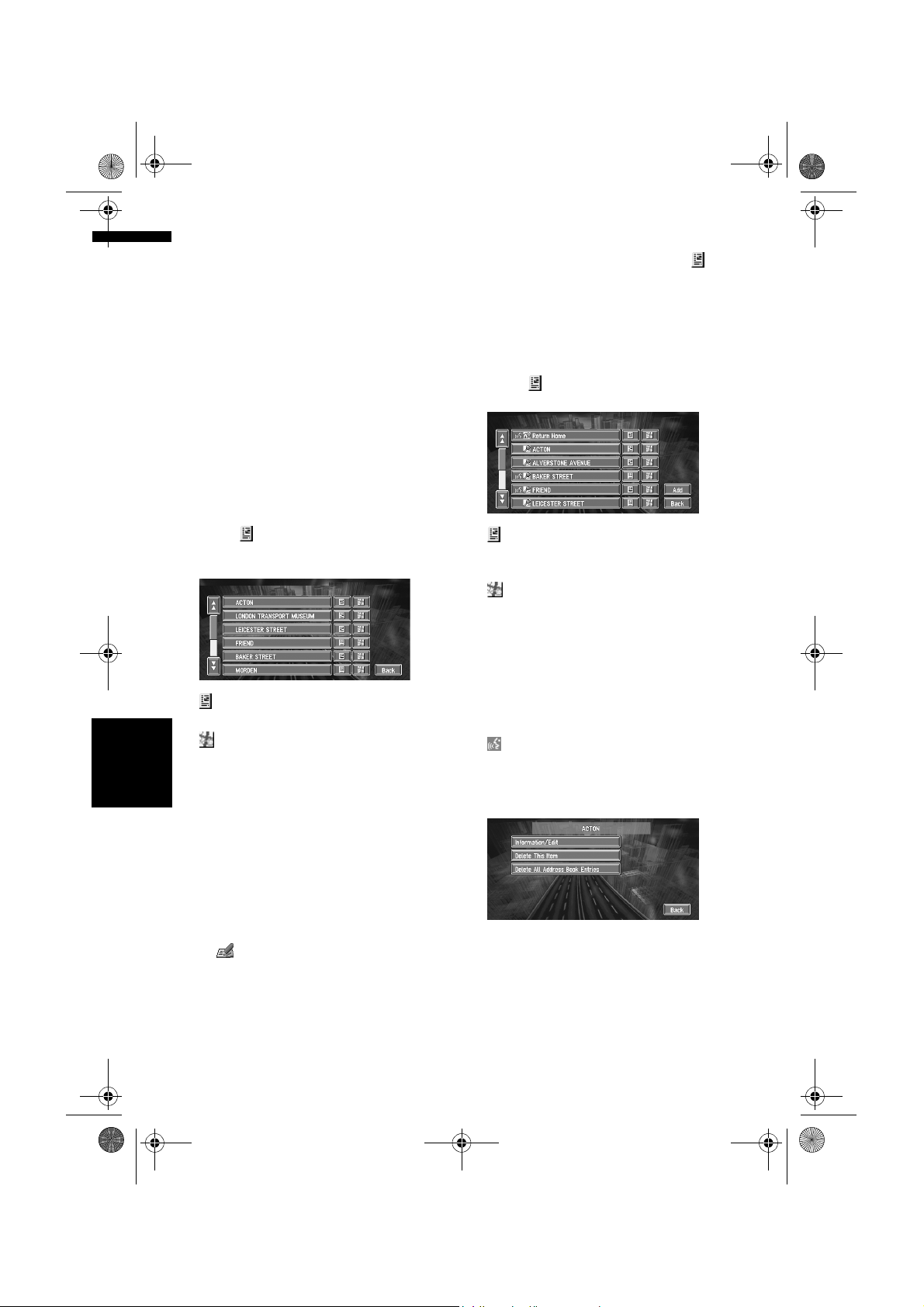
MAN-CNDV-50MT-EN.book Page 42 Wednesday, May 4, 2005 1:49 PM
Registering a previous location
in the Address Book
Once a destination or way point is searched, it is
automatically retained and stored in the
Destination History. If a search is cancelled
while still in progress, only the places where the
map was displayed and scrolled through or
places where the short-cut menu was displayed
are retained and stored. Note that after 100
places are stored, new places are automatically
overwritten on top of old ones, in oldest to most
recent order. Therefore, to ensure that certain
places are kept and not overwritten, be sure to
register them in the Address Book.
1 Touch “Destination” in the Main menu,
then touch “Destination History”.
2 Touch on the right-hand side of the
place you want to register in the Address
Book.
:
That place can be registered or deleted.
:
The map of that place can be displayed.
➲ Searching the destination by map ➞
Chapter 4Editing the Navigation Utilities NAVI
Page 27
3 Touch “Registration”.
Editing a location’s information
In the Address Book menu, touching the on
the right-hand side of the place displays the
Address Book Operate menu.
To edit the information about the location:
1 Touch “Destination” in the Main menu,
then touch “Address Book”.
2 Touch on the right-hand side of the
place whose information you want to edit.
:
The information related to that place can be
edited.
:
The map of that place can be displayed.
➲ Searching the destination by map ➞
Page 27
Add:
The screen for selecting the method for
registering the location in the Address Book
appears.
➲ Registering the location ➞ Page 29 to 32
:
Displayed on the left-hand side of places that
can be searched by voice command.
3 Touch “Information/Edit”.
4 Touch “Save”.
Registration is now complete.
❒ If you want to stop registration, touch
“Back”.
➲ “Editing a location’s information” ➞
Page 42
➲ in the Shortcut menu ➞ Page 22
42
The Address Information menu appears. Refer
to the item corresponding to the subsequent
operation. After finishing the operation, the
Address Book menu appears. You can
continue to edit other information items if
necessary.
Page 45

MAN-CNDV-50MT-EN.book Page 43 Wednesday, May 4, 2005 1:49 PM
(1)
(2)
(3)
(4)
(5)
(6)
(1) Name
The name can be used as a command for
voice operation.
(2) Name (2nd line)
The name of the city appears in this column.
(Not editable)
(3) Phone number
(4) Pictograph
The symbol displayed on the map.
(5) Sound
The selected operating sound is played.
(6) Modify Location
You can change the registered location by
scrolling the map.
Changing a name
1 Touch “Edit Name” and touch “Yes”.
The message confirming whether or not to
register the entered name as voice command
is displayed.
Alternative option:
No:
When not registering a name as a voice
command, select “No”.
2 Enter a new name; touch “OK”.
The name of the current location appears in
the text box. Delete the current name, and
enter a new name between 6 and 23
characters long. (If you selected “No” in Step
1, you can enter a new name between 1 and
23 characters long.)
3 If the pronunciation is correct, touch
“Yes”.
❒ When you select “Yes”, is shown on the
❒ You cannot change the name of your home.
❒ During voice operation, you can get a route
➲ Information on voice operation ➞ Chapter 9
Entering or changing a phone number
1 Touch “Edit Phone Number”.
2 Input a phone number; touch “OK”.
Selecting a pictograph to appear on the
map
1 Touch “Select Image”.
2 Touch the Pictograph to appear on the
Selecting sound
1 Touch “Select Sound”.
The details you set are registered, and the
Address Book menu appears.
Alternative options:
No:
Select to return to the display for entering
characters.
Repeat:
You can reconfirm the pronunciation of the
name you entered.
left side of the location name displayed in the
Address Book menu. This mark indicates that
this name can be used as a voice command
during voice operation.
calculated by saying the registered name.
The Address Information menu appears.
❒ To change a registered phone number,
delete the existing number and then enter
a new one.
Chapter 4 Editing the Navigation UtilitiesNAVI
map.
The Address Information menu appears.
❒ You cannot change the mark of your home
or of your favourite location.
2 Select the sound.
The Address Information menu appears.
If you want to hear the operating sound, touch
.
Modify the location
➲ Changing the position of locations ➞ Page 44
43
Page 46

MAN-CNDV-50MT-EN.book Page 44 Wednesday, May 4, 2005 1:49 PM
Deleting Address Book or
Destination History information
Items registered in the Address Book or
Destination History can be deleted. All entries
of the data in the Address Book or Destination
History can be deleted at once.
1 Touch “Destination” in the Main menu,
then touch “Address Book”.
To delete items in the Destination History,
touch “Destination History”.
2 Touch on the right-hand side of the
place you want to delete.
3 Select the deletion method.
A message confirming deletion appears.
Alternative options:
Delete This Item:
Delete the location selected in Step 2.
Delete All Address Book Entries (or
Delete All Destinations):
Delete all the Address Book or Destination
History data.
4 Select “Yes”.
The data you selected is deleted.
Chapter 4Editing the Navigation Utilities NAVI
Alternative option:
No:
The display shown in Step 3 appears.
❒ Because deleted data cannot be restored,
take extra care not to select “Delete All
Address Book Entries” by mistake.
1 In the Address Book menu, touch on
the right-hand side of the place whose
position you want to change.
2 Touch “Information/Edit”, and then touch
“Modify Location”.
The map of the selected area and its
surroundings appears.
3 Touch the display to change its position,
then touch “OK”.
The position is changed.
❒ Touching “Back” returns to the previous
screen without changing the location.
Loading registered locations
data from a CD-R
Address Book data stored on a CD-R (-RW) can
be loaded to the Navigation System.
This function is used when moving Address Book
data from a Pioneer navigation unit with a PC
card slot (e.g., AVIC-900DVD) to a Pioneer
navigation unit without a PC card slot (e.g., AVICX1R).
❒ When moving data, copy the folder named
“POINT” from the PC card to the personal
computer. Then use the personal computer to
store the “POINT” folder in the first level of
the CD-R (-RW).
1 Insert the CD-R (-RW) to the disc loading
slot.
2 Touch “Settings” in the Main menu, then
touch “System Options”.
Changing the position of
locations registered in the
Address Book
You can select a location registered in the
Address Book, display a map of its
surroundings, and change its position.
44
3 Touch “Read from Disc”.
The list of groups appears.
4 Touch the desired group.
5 Touch the desired locations.
Selected locations are marked. To load the
data from other locations, repeat this step.
Page 47

MAN-CNDV-50MT-EN.book Page 45 Wednesday, May 4, 2005 1:49 PM
Alternative option:
Select All:
All the locations are selected (or cancelled) at
once.
6 Touch “OK”.
The data of the selected locations is stored in
the Address Book.
Setting Areas to Avoid
If you register Areas to Avoid, such as crowded
intersections or congested areas, routes can be
calculated that avoid those areas. Areas to
Avoid can be set from the Route Options menu.
Registering an area to avoid
This section describes how to register an Area to
Avoid for the first time. You can register up to five
Areas to Avoid.
1 Touch “Route Options” in the Main menu,
then touch “Areas to Avoid”.
2 Select one of the items shown in “New
Area”.
When registering for the first time, any item
on the list is shown as “New Area”.
5 Scroll the map, adjust the position of the
red frame, and touch “OK”.
If you want to stop registration, touch “Back”.
❒ Depending on the setting of route search
conditions, you may not be able to avoid the
specified areas. The confirmation message is
displayed on the screen at this time.
➲ Information on route calculation conditions ➞
Page 34
Changing or deleting an area to
avoid
You can subsequently change/rename/delete an
Area to Avoid.
1 Touch “Route Options” in the Main menu,
then touch “Areas to Avoid”.
2 Select the area you want to change or
delete.
3 Select the place to register and display
the map.
➲ Searching places to register ➞ Page 29 to
32
Once a search is complete, a map with the
specified location at its centre appears.
4 Change the map scale and decide the size
of the Area to Avoid.
The Area to avoid is enclosed in a red frame.
You can also change the map scale though
the maximum map scale for registering Areas
to Avoid is 100 m (0.1 mile).
3 Select the desired operation.
Chapter 4 Editing the Navigation UtilitiesNAVI
On this screen, you can select the following
options:
Rename:
Changes the name. Enter the new name and
touch “OK”. This returns you to the Route
Options menu.
Change:
A specified area can be changed. For the next
steps, see Step 3 in the “Registering an area
to avoid” above.
Delete:
Delete the selected Area to Avoid.
45
Page 48

MAN-CNDV-50MT-EN.book Page 46 Wednesday, May 4, 2005 1:49 PM
Using Traffic Information
You can check traffic information transmitted by
the FM radio service through the Radio Data
System (RDS-TMC) on the display. Such traffic
information is updated periodically. When you
receive traffic information, the Navigation System
automatically displays an icon informing you of
the traffic information. You can also select
whether to recalculate the route to avoid a traffic
jam. (In this case, route calculation is carried out
by considering traffic jam within a 150 km (92
mile) radius from your current location.)
❒ The”traffic jam” in this section indicated the
following types of traffic information; stop and
go, stopped traffic, closed/blocked roads.
These information are always taken into
consideration for checking your route, and the
infromation related with these events cannot
be turned off.
Viewing traffic information
Traffic Information is displayed onscreen in a list.
This allows you to check how many traffic
incidents have occurred, their location, and their
distance from your current position.
Checking all traffic information
1 Touch “Traffic/Info” in the Main menu,
then touch “All Traffic”.
The list with received traffic information is
shown.
Chapter 4Editing the Navigation Utilities NAVI
2 Touch or to view the incident list.
Places (street names) where incidents have
occurred are displayed in the list.
(1) (2) (5)(4)
(3)
(1) Street or place name
(2) Direction
(3) Incident
(4) Distance to the location
(5) The incident numbers currently
displayed and the total number of
incidents
❒ The incidents that have already been read
will be displayed in white. Unread
incidents will be in yellow.
❒ Touching the allows you to check the
place on a map. (Traffic information
without positional information cannot be
checked on a map.)
:
You can sort the traffic information in
alphabetical order.
:
You can sort the traffic information according
to the incident.
:
You can sort the traffic information by
distance from your current position.
:
When new traffic information is received,
current information is changed, or old
information has been removed, the list is
updated to reflect the new situation.
46
3 Select an incident you want to view in
detail.
The details of the selected incident are
displayed.
• Touching an incident you want to see
allows you to view the detailed information
of the incident. If the information cannot be
displayed on one screen, touch or to
view the remaining information.
Page 49

MAN-CNDV-50MT-EN.book Page 47 Wednesday, May 4, 2005 1:49 PM
4 Touch “Back” to return to the list with
traffic information.
A list with traffic information appears again.
Checking traffic information on the
route
1 Touch “Traffic/Info” in the Main menu,
and then touch “Traffic On Route”.
The currently set traffic information on the
route appears on the screen.
❒ The method for checking the content
displayed on the screen is the same for
“Checking all traffic information”.
➲ Checking all traffic information ➞ Page 46
Confirming traffic information on the
map
The traffic-related information displayed on the
map is as follows.
(1)
(3)(2)
(3) Icon for traffic information
(appears only when the scale on the map is 20
km or lower)
❒ The traffic jam lines to indicate the length of
the traffic jam and traffic-related icons are not
displayed on city maps.
➲ “Selecting traffic information to display” ➞
Page 48
If you want to check the traffic information
details, move the scroll cursor onto the , etc.
and touch . This allows you to view place
names and other information.
Information on avoiding traffic
jam on route ahead
If there is a traffic jam on your route (at least 1 km
(0.75 miles) ahead on an ordinary road, while
driving on the motorway, 2.6 km (1.6 mi) ahead),
the Navigation System automatically searches for
a detour possibility.
If a better route can be calculated, the following
screen will appear.
(or , ):
(1) Name of the service provider, radio
station or frequency currently being
received.
➲ Selecting the radio station ➞ Page 49
❒ When is displayed, reading from the
map disc is required. Please insert the map
disc.
❒ When is displayed, the data is being
loaded from the map disc.
When a route has been calculated, touch to
check whether there is any traffic jam
information on your route. When no route has
been calculated, touch to display the traffic list.
(2) A line to indicate the length of the traffic
jam
(displayed only when the scale on the map is 1
km (0.75 mi) or lower; Stop and go: orange,
Stopped traffic: red, Closed/blocked roads: black)
Chapter 4 Editing the Navigation UtilitiesNAVI
Difference in distance and travel time between
existing route and new route
Distance from the current position of your vehicle
to the point of entry into the new route.
On this screen, you can select the following
items:
New:
A new route is displayed on the screen.
Current:
The current route is displayed on the screen.
OK:
Select the route to that displayed on the screen.
❒ When no selection is made, the current route
will be automatically selected after a short
while.
47
Page 50

MAN-CNDV-50MT-EN.book Page 48 Wednesday, May 4, 2005 1:49 PM
When checking traffic jam
information manually
Touching on the screen allows you to
check for traffic jam information on your route.
If there is any information about a traffic jam on
your route, a message appears asking you
whether to search for another route to avoid the
traffic jam. If there is no traffic jam information
along the route being guided, it is announced on
screen and by voice.
If there is a traffic jam on the route
When receiving information about a traffic jam,
the message announcing the presence of a
traffic jam is indicated. (Voice recognition then
becomes available automatically when the
microphone is connected.)
On this screen, you can select the following
items:
Yes:
The route is recalculated taking the traffic jam
into account.
No:
The message disappears, and the map display
reappears.
List:
The list with traffic information on the route
displayed.
❒ In Memory Navi mode, no detailed
information is available for traffic information
on List.
If there is no traffic jam information on
the route
Chapter 4Editing the Navigation Utilities NAVI
If there is no traffic jam information, the message
informing that there is no traffic jam information
on the route, is shown.
On this screen, you can select the following
items:
List:
The list with all traffic information is displayed.
Back:
Message disappears, and returns to the map
screen.
❒ In the memory navi mode, you cannot touch
other than Back.
❒ If there is no traffic jam information, the
Navigation System does not automatically
switch to voice recognition.
Selecting traffic information to display
Select the type of traffic information to display
with the navigation system.
1 Touch “Traffic/Info” in the Main menu,
and then touch “Traffic Settings”.
The icon for the traffic information currently
being displayed appears on the screen.
2 Touch “Change”.
The name of the displayed traffic information
items and list of icons appears on the screen.
3 Touch the traffic information item to
display.
A red tick appears next to the selected traffic
information.
❒ Touching “All” selects all the traffic
information.
❒ Touch “Back” to not add the selected
traffic information.
4 Touch “Done”.
The selected traffic information icon is added
to the screen.
5 Touch “Back”.
48
Page 51

MAN-CNDV-50MT-EN.book Page 49 Wednesday, May 4, 2005 1:49 PM
Selecting the radio station
The RDS-Tuner of the navigation system
automatically tunes to the radio station to receive
available traffic information (RDS-TMC station). If
reception is poor, you can switch to another
station manually. Once the receiving radio
station is selected, the system automatically
tunes to stations that provide traffic information
according to the location of the vehicle.
Tuning to a RDS-TMC station with
good reception
1 Touch “Traffic/Info” in the Main menu,
then touch “Manual Station Search”.
2 Touch “Next”.
Available radio stations can be searched
automatically. If a radio station with a good
reception is found, the tuning mode is
stopped.
Alternative option:
Store:
Store the current RDS-TMC station in the
preset list. If there are already five stations
stored in the list, select one to be overwritten.
❒ If you want to continue to search for
another station, repeat this procedure.
3 Touch “OK”.
Switches to the selected RDS-TMC station
and returns to the Information menu.
Selecting from pre-registered RDSTMC stations
You can pre-select up to five RDS-TMC stations
(Preset Station). From the list of the RDS-TMC
stations, you can select the one you want to
receive.
1 Touch “Traffic/Info” in the Main menu,
then touch “Manual Station Search”.
The list of registered RDS-TMC stations
appears. This list of broadcasting stations
(Preset Station) cannot be used unless those
broadcasting stations have been stored.
2 Select a radio station on the list.
The currently selected RDS-TMC station
Switching to the specified RDS-TMC station.
Changing Background Picture
In the menu operation screen, you can indicate a
picture you like on the background. Some
pictures are already stored, but you can also use
pictures (JPEG format data) created by a
personal computer or a digital camera. If you
save the pictures to a CD-R (or CD-RW), you can
use them as background pictures. The following
two types of background pictures can be
changed:
• AV Background: Background for the screen
during the operation of audio, or during
playback.
• Navigation Background: Background of
navigation menu screen.
Several background pictures are stored in the
Pioneer DVD map disc. If you want to use these
pictures, insert the Pioneer DVD map disc.
Here, a method of changing background picture
is described with an example of loading the
picture stored on a CD-R (-RW) onto the
navigation system as the background picture.
❒ When storing original pictures on a CD-R (-
RW), create a folder named “BG” in a CD-R (RW), and store the picture files in this folder.
Up to 20 picture files can be used in the BG
folder.
Chapter 4 Editing the Navigation UtilitiesNAVI
49
Page 52

MAN-CNDV-50MT-EN.book Page 50 Wednesday, May 4, 2005 1:49 PM
❒ When creating a “Background Picture
Setting” CD-R (-RW) for changing the
navigation unit background picture, make
sure the total data size of the CD-R (-RW) is
greater than 100MB. However, you cannot use
a CD-R (-RW) containing MP3 files or the
Audio data part (CD-DA session) for the
“Background Picture Setting” function.
❒ Only JPEG format (“.jpg” or “.JPG”) pictures
can be used as a background picture.
❒ You can only use standard characters
(alphabets of both cases: A-Z, a-z) and
numbers (0-9) for the file name of a
background picture (international (accented)
characters cannot be used).
❒ Pictures up to a maximum of 2048×1536
pixels can be used. We cannot guarantee a
proper operation for a picture bigger than this
size.
❒ Progressive format JPEG pictures cannot be
used.
1 Insert a CD-R (-RW) to the disc loading
slot.
2 Touch “Settings” in the Main menu, then
touch “System Options”.
3 Touch “Background Picture Setting”.
The picture selected for each screen is
indicated on the right side of “AV
Background” and “Navigation
Background” items.
Chapter 4Editing the Navigation Utilities NAVI
4 Touch “Navigation Background” or “AV
Background”.
5 Touch “Import from Disc”.
The list of the pictures stored in a CD-R (-RW)
is displayed.
On this screen, you can select the following
item:
Back to Original:
The picture when purchased is selected.
❒ When a CD-R (or CD-RW) is inserted, you
cannot select “Back to Original”. When
the Pioneer DVD map disc is inserted, you
cannot select “Import from Disc”.
❒ In step 5, touching other than “Import
from Disc” allows you to select a
background image stored on the Pioneer
DVD map disc.
6 Touch a picture you want for the
background.
7 Select how to display the picture.
You can select the following items:
“Centre”:
Selected picture is displayed at the centre of
the screen.
“Repeat”:
Selected picture is patterned, and displayed
as covering the whole screen.
❒ When selecting images already stored on
the Pioneer DVD map disc, you cannot
select the layout method for those images.
The background image starts changing. After
a short while, the new background image
appears.
8 Touch “Done”.
On this screen, you can select the following
items:
Select another Picture:
This is selected when you want to change to
another picture. Return to Step 5.
Change to another background:
Select if you want to successively change the
Audio Operating screen backgrounds or the
Navigation backgrounds. Return to step 3.
❒ When changing a picture starts, do not cut
off the vehicle engine until the message
informing the completion of changing a
picture is indicated.
50
Page 53

MAN-CNDV-50MT-EN.book Page 51 Wednesday, May 4, 2005 1:49 PM
❒ When the Navigation System is reset, or
the language setting is changed, the
background picture may change back to
the original picture. (There is also a
possibility that the system will revert to the
original picture for some other reason.) If
this happens, set the background picture
again.
Checking the Navigation Status
The navigation status, including the driving
status of a vehicle, positioning status by satellite,
learning status of the 3D sensor, and cable
connection status can be checked.
Checking sensor learning status
and driving status
1 Touch “Settings” in the Main menu, then
touch “Hardware Info”.
2 Touch “3D Calibration Status”.
The 3D Calibration Status screen appears.
(1)
(2)
(3)
(4)
(5)(7)(6)
(1) Distance
Driving distance is indicated.
(2) Speed Pulse
Total number of speed pulses is indicated.
(3) Learning Status
Current driving mode is indicated.
(4) Degree of learning
Sensor learning situations of distance
(Distance), right turn (Right Turn), left turn
(Left Turn), and 3D detection (3D Detection)
are indicated by the length of bars.
(5) Speed
Speed detected by this unit is indicated. (This
indication may be different from the actual
speed of your vehicle, so please do not use
this instead of the speedometer of your
vehicle.)
(6) Acceleration or deceleration/
Rotational speed
Acceleration or deceleration velocity of your
vehicle is indicated. Also, rotational speed
when your vehicle turns to left or right is
shown.
(7) Inclination
Degree of slope of the street is indicated.
Chapter 4 Editing the Navigation UtilitiesNAVI
51
Page 54

MAN-CNDV-50MT-EN.book Page 52 Wednesday, May 4, 2005 1:49 PM
To clear values...
If you want to delete the learned results stored in
“Distance”, “Speed Pulse” or “Learning
Status”, touch the relevant result, then touch
“Clear”.
❒ The Navigation System can automatically use
its sensor memory based on the outer
dimensions of the tyres.
Checking the connections of
leads and installation positions
Check that leads are properly connected between
the navigation unit and the vehicle. Please also
check whether they are connected in the correct
positions.
1 Touch “Settings” in the Main menu, then
touch “Hardware Info”.
2 Touch “Connection Status”.
The Connection Status screen appears.
(1)
(2)
(3)
(4)
(5)
(6)
(7)
Setting the Vehicle Dynamics
Display
(1) Speed Pulse
The Speed Pulse value detected by this unit is
shown. “0” is shown while the vehicle is
Chapter 4Editing the Navigation Utilities NAVI
stationary.
(2) GPS Aerial
Indicates the connection status of the GPS
aerial, the reception sensitivity, and from how
many satellites the signal is received.
If the signal is received correctly, “OK” is
displayed. If reception is poor, “NOK”
appears.
(3) Installation Position
The Installation position of the navigation unit
is shown.
You can change the values displayed by the
instruments on the left and right of the Vehicle
Dynamics Display.
Until the sensor’s initial learning is complete,
only the voltage and clock are displayed.
1 Switch to the Vehicle Dynamics Display.
2 Touch the left or right instrument.
If installed correctly, “OK” appears. Indicates
whether the Installation position of the
navigation unit is correct or not. When the
navigation unit is installed with an extreme
angle exceeding the limitation of the installing
angle, “Incorrect angle” will be displayed.
When the angle of the navigation unit has
been changed, “Excessive vibration” will be
displayed.
(4) Hand brake
When the handbrake is applied, “On” is
displayed. When the handbrake is released,
“Off” is displayed.
(5) Power Voltage
The power supply (reference value) provided
from the vehicle battery to this unit is shown.
If the voltage does not fall within the range of
11 to 15V, check that power cable connection
is correct.
(6) Illumination
When the headlights or small lamps of a
vehicle are on, “On” is displayed. (If the
orange/white lead is not connected, “Off”
appears.)
(7) Back Signal
When the gear lever is shifted to “R”, the
signal switches to “High” or “Low”. (Which of
these is displayed depends on the vehicle.)
➲ Changing the map display mode ➞
Page 22
Touch keys are displayed.
52
Page 55

MAN-CNDV-50MT-EN.book Page 53 Wednesday, May 4, 2005 1:49 PM
3 Touch the items you want to display.
You can select the following items.
• Voltage:
Displays the power supply and voltage
supplied from the battery to this system.
• Acceleration:
Acceleration in a forward direction is
displayed. The + sign indicates acceleration
while the – sign indicates deceleration.
• Side Acceleration:
Acceleration in a side direction such as when
turning, is displayed. The + sign indicates a
right turn, while the – sign indicates a left
turn.
• Angular Velocity:
Displays the vehicle’s turning angle over one
second (how far it has turned in a second).
• Slope:
Displays the vehicle’s vertical movement. The
+ side represents the rising angle, and the side the falling angle.
• Direction:
The direction your vehicle is travelling in is
displayed.
• Clock:
Current time is displayed.
• Adjust Look:
Touch “Adjust Look” to display a screen for
selecting the panel pattern. Touch one of the
patterns from among those displayed
onscreen to change the panel to the selected
pattern.
❒ If you touch “Peak Hold Reset”, the
maximum and minimum (green line)
values indicated in “Acceleration” and
“Side Acceleration” are reset.
❒ You cannot change the speedometer at the
centre.
❒ Selecting Demo mode in the Settings
menu enables you to perform a
demonstration with random values.
Chapter 4 Editing the Navigation UtilitiesNAVI
53
Page 56

MAN-CNDV-50MT-EN.book Page 54 Wednesday, May 4, 2005 1:49 PM
Chapter 4Editing the Navigation Utilities NAVI
54
Page 57

MAN-CNDV-50MT-EN.book Page 55 Wednesday, May 4, 2005 1:49 PM
Customising Your Navigation System
• For safety reasons, these functions are not
available while your vehicle is in motion.
To enable these functions, you must stop
in a safe place and put on the handbrake
before setting your route.
Modifying the Default Settings
You can tailor default settings such as navigation
functions and information display for ease of use.
The following example describes how to change
settings. In this example, the “KM Mile Setting”
settings is set to “Mile”.
1 Touch “Settings” in the Main menu.
The Settings menu appears.
2 Touch “System Options”.
The screen changes. “km” is displayed below
“KM Mile Setting”, indicating that this
function is currently set to “km”.
❒ When you touch items with a setting below
them, their setting changes. When you
touch items with no setting below them, a
setting screen appears.
❒ Touching “Back” switch to Settings
Menu.
Items Users can Change
This section describes the details of the setting
for each item. Settings marked with an asterisk
(*) show that they are default or factory settings.
Volume
The sound volume for the navigation can be set.
You can separately set the volume of the route
guidance and of the beep sound.
Chapter 5
“Mile” is displayed below “KM Mile Setting”,
indicating that “KM Mile Setting” is set to
“Mile”.
If you want to change another setting, select
the item you want to change and repeat the
procedure in step 3.
Chapter 5 Customising Your Navigation SystemNAVI
3 Touch “KM Mile Setting”.
Guidance volume
Touch “+” or “–” to change the Guidance volume.
Beep volume
Touch “+” or “–” to change the Beep volume.
❒ Volume of the audio source is adjusted by the
VOLUME dial of the navigation unit.
Mute Settings
Items related to muting of sound volume can be
set.
❒ When Voice Guidance or Voice Recognition
are ON, be sure to set the TEL/GUIDE setting
in the Audio Menu to MUTE or ATT.
55
Page 58

MAN-CNDV-50MT-EN.book Page 56 Wednesday, May 4, 2005 1:49 PM
• Voice Recognition
This setting controls whether the volume of the
Audio source is automatically muted during voice
operation.
On*:
During voice operation, the volume of the Audio
source is muted automatically.
Off:
The volume of the Audio source stays the same
during voice operation.
❒ If you select “Off”, the sound from the Audio
source may interfere with the voice
recognition system.
• Voice Guidance
This setting controls whether the volume of the
Audio source is automatically muted during voice
guidance.
On*:
Chapter 5Customising Your Navigation System NAVI
During voice guidance, the volume of the Audio
source is muted automatically.
Off:
Volume of the Audio source stays the same
during voice guidance.
System Options
Touch “System Options” in the Setting Menu to
display.
Language Selection
➲ The language displayed can be set ➞
Page 107
Once you change the language, installation of
the program starts.
• Once the installation of the program starts,
do not stop the engine of your vehicle and
do not switch off the Navigation System
until the installation is completed and the
map of your surroundings appears.
KM Mile Setting
This setting controls the unit of distance
displayed on your Navigation System.
km*:
Show distances in kilometres.
Mile:
Show distances in miles.
Mile & Yard:
Show distances in miles and yards.
Voice Recog.Help
This setting controls the list of available voice
commands displayed during voice operation.
You should set “Voice Recog.Help” only when
the microphone of the voice recognition system
(sold separately) is connected.
On*:
The list of commands is shown.
Off:
The list of commands is not shown.
Auto Voice Recognition
After you have started the engine, turn on voice
recognition and set whether or not to perform all
operations up to route searching by voice.
(This function is effective only when a route is not
set.)
❒ You should set “Auto Voice Recognition”
only when the microphone of the voice
recognition system (sold separately) is
connected.
❒ In order to operate the navigation unit by
voice, you need the microphone kit (CD-VC1),
which is sold separately. Before connecting
the microphone, be sure to first turn the
ignition switch OFF (ACC OFF). When the
microphone is connected, turn the ignition
switch ON (ACC ON).
On:
The automatic voice recognition is engaged each
time your vehicle is started.
Off*:
Voice operation starts after touching VOICE
icon.
Average Speed
When calculating expected time of arrival and the
number of hours to the destination, set the
average speed for the motorway or ordinary road
using “+” and “–”.
56
Page 59

MAN-CNDV-50MT-EN.book Page 57 Wednesday, May 4, 2005 1:49 PM
• Minor Ordinary Road
• When the “KM Mile Setting” is set to “km”, it
can be set in 5 km increments from 20 km to
110 km (40 km*).
• When the “KM Mile Setting” is set to “Mile”
or “Mile & Yard”, it can be set in 5 mile
increments from 10 miles to 100 miles (30
miles*).
• Major Ordinary Road
• When the “KM Mile Setting” is set to “km”, it
can be set in 5 km increments from 20 km to
150 km (60 km*).
• When the “KM Mile Setting” is set to “Mile”
or “Mile & Yard”, it can be set in 5 mile
increments from 10 miles to 120 miles (40
miles*).
• Motorway
• When the “KM Mile Setting” is set to “km”, it
can be set in 5 km increments from 60 km to
150 km (120 km*).
• When the “KM Mile Setting” is set to “Mile”
or “Mile & Yard”, it can be set in 5 mile
increments from 30 miles to 120 miles (80
miles*).
Background Picture Setting
➲ The background picture can be changed ➞
Page 49
Read From Disc
➲ Read From Disc ➞ Page 44
Short-Cut Selection
Select shortcuts to display on the map screen. In
the list displayed onscreen, the items with red
ticks are displayed on the map screen.
Touch the shortcut you wish to display and then
touch “Done” when a red tick appears. You can
select up to three shortcuts.
➲ Register to Address Book ➞ Page 42
Vicinity Search *
Find POIs (Points Of Interest) in the vicinity of the
scroll cursor.
➲ Searching the facilities surrounding a certain
place ➞ Page 30
Whole Route Overview *
Displays the entire currently set route.
Overlay POI
Displays on the map the mark for surrounding
facilities (POI).
➲ Viewing POI information ➞ Page 31
Address Book
Displays the Address Book.
➲ Displays the Address Book ➞ Page 41
Route Options
Displays the Route Options menu.
➲ Displays the Route Options menu. ➞ Page 33
Edit Current Route
Displays the screen for rerouting or adding or
deleting way points.
➲ Adding or deleting way points ➞ Page 38
Traffic On Route
Displays traffic information on the route.
Use this menu for the following operations.
• Displaying a list of traffic information on the
route.
➲ Displays traffic information on the route ➞
Page 47
Map Display Options
Touch “Map Display Options” in the Setting
Menu to display.
Chapter 5 Customising Your Navigation SystemNAVI
Registration *
The location indicated by the scroll cursor is
registered in the Address Book.
Tracking Display
The tracking display setting has the following
options.
Always:
Display tracking for all journeys.
57
Page 60

MAN-CNDV-50MT-EN.book Page 58 Wednesday, May 4, 2005 1:49 PM
This Trip:
Display tracking dots but erase them when the
navigation system is turned off (when turning off
the engine of your vehicle).
Off*:
Do not display tracking dots.
AV Guide Mode
Setting whether or not to switch to the navigation
screen automatically when your vehicle
approaches a guidance point such as an
intersection while displaying a screen other than
navigation.
On*:
Switching from audio operation screen to
navigation screen.
Off:
Screen is not switched.
Chapter 5Customising Your Navigation System NAVI
Day/Night Display
To improve the visibility of the map during the
evening, you can change the combination of the
colours of the map.
Illuminated*:
You can change the combination of the colours
of a map according to whether the vehicle lights
are On or Off.
Daytime:
The map is always displayed with bright colours.
Close-up of Junction
This setting enables to switch to an enlarged map
around the point where your vehicle is
approaching an intersection, entrance/exit of
motorway, or a junction.
On*:
Display switches to an enlarged map.
Off:
Does not switch to an enlarged map.
Arrow in AV
Set whether to display the guidance information
by arrow on the Audio Operation screen.
On*:
Display guidance information by arrow on the
Audio Operation screen.
Off:
Do not display guidance information by arrow on
the Audio Operation screen.
Defined Locations
Touch “Defined Locations” in the Setting Menu
to display.
Set ”Home”
➲ Registering and changing your home location
➞ Page 41
Map In Memory
The memory area is the area in the map, which is
being read in advance for the memory navi mode.
There are two ways of setting the memory area.
Around Current Position
An approximately 17 km (10.6 mile) square on a
side with the selected location at the centre is
read into the memory.
Indicate the map you want to store in the memory
by touching 4, 6, 8 or 2. Then, adjust the map
scale to the one you desire, and touch “OK”.
Continuously touching 4, 6, 8 or 2 allows you to
rapidly scroll the map screen.Restrictions apply
to the distances that can be saved.
Around Current Route
Sets the the surrounding currently set route to
the memory area. The route to the destination will
appear on screen. Please press “OK”.
❒ If the route is not set, “Around current
Route” cannot be set.
❒ The extent of the information that can be set
in the memory area is about 10.6 km (6.6 mi)
surrounding the route.
Set ”Go To”
➲ Registering and changing your favourite
location ➞ Page 41
58
Page 61

MAN-CNDV-50MT-EN.book Page 59 Wednesday, May 4, 2005 1:49 PM
Demo Mode
This is a demonstration function for shops. After
a route is set, the simulation of the route
guidance to a destination is automatically
displayed. Normally, set this to “Off”.
On (Repeat):
Repeat demo drive.
Off*:
Demo Mode is set off.
❒ If you eject the map disc during the demo
drive, the demo mode will be stopped.
Time
Adjusts the systems clock. The time difference
(+, –) between the time originally set in this unit
is set here.
You can also select summer time On/Off.
➲ Time settings ➞ Page 108
On:
Summer time is taken into account.
Off*:
Summer time is not taken into account.
❒ When the period of summer time comes, or
when the summer time ends, this unit does
not automatically change the summer time
setting.
➲ Change the summer time setting ➞ Page 108
3D Calibration Status
➲ 3D Calibration Status ➞ Page 51
Service Info Screen
Displays the disc production number and version
information.
Restore Factory Settings
Reset various settings registered to the
Navigation
System and restores to the default or factory
settings. To restore, touch “Yes”.
❒ When you restore the settings to their status
at shipping, the information set in the
Address Book, Destination History,
Overlay POI Areas to Avoid, Language
Selection, Time, Return Home, Go to,
Modify Current Location, Background
Picture Settings, Defined Locations, and
Short-Cut Selection menus is not deleted.
Chapter 5 Customising Your Navigation SystemNAVI
Modify Current Location
Touch the screen to adjust the current position
and direction of the vehicle displayed on the map.
Hardware Info
Touch “Hardware Info” in the Setting Menu to
display.
Connection Status
➲ Connection Status ➞ Page 52
59
Page 62

MAN-CNDV-50MT-EN.book Page 60 Wednesday, May 4, 2005 1:49 PM
Chapter 5Customising Your Navigation System NAVI
60
Page 63

MAN-CNDV-50MT-EN.book Page 61 Wednesday, May 4, 2005 1:49 PM
Using the AV Source (Built-in DVD drive and Radio)
Chapter 6
You can play a DVD-Video, CD, MP3 disc or use
the radio with the navigation unit. This chapter
describes how to use the audio source and the
basic operation of the audio source.
Basic Operation
➲ For information on most basic operations,
refer to “How to listen to a CD” ➞ Page 18
Activating the touch panel keys
(1)
(1) Touch panel keys
Touch to do various operations.
1 Press the NAVI/AV button to switch
Audio operation screen.
To go to the next group of touch panel keys,
touch ➞.
3 Touch “ESC” to hide the touch panel
keys.
❒ If you do not use the touch panel keys for
30 seconds, they will be hidden
automatically.
Basic Operation
How to display each menu
1 Press the NAVI/AV button to switch
Audio operation screen.
Chapter 6 Using the AV Source (Built-in DVD drive and Radio)AV
2 Select the desired source.
3 Touch the screen.
Touch keys are displayed on the screen.
4 Touch “A.MENU” to display MENU.
2 Touch the screen to activate the touch
panel keys corresponding to each source.
The touch panel keys appear on the display.
Touch keys (e.g., CD)
61
Page 64

MAN-CNDV-50MT-EN.book Page 62 Wednesday, May 4, 2005 1:49 PM
5 Touch “AUDIO”, “FUNCTION” or “SETUP” to enter the menu you want to operate.
Each menu is displayed. The items that cannot be operated according to the sources or conditions
are indicated in grey.
FUNCTION menu
(2)
(1)
Basic Operation
AUDIO menu SETUP menu
(3)
Chapter 6Using the AV Source (Built-in DVD drive and Radio) AV
(4) (5)
(1) FUNCTION key
Touch to enter the FUNCTION menu for each source.
➲ Using the FUNCTION menu ➞ “Operation using the FUNCTION menu” and “Advanced
<each source> operation”
(2) AUDIO key
Touch to select various sound quality controls.
➲ Using the AUDIO menu ➞ Page 89
(3) SETUP key
Touch to select various setup functions.
➲ Using the SETUP menu ➞ Page 96
(4) BACK key
Touch to return to the previous display.
(5) ESC key
Touch to cancel the control mode of functions.
6 Touch “ESC” to return to the display of each source.
❒ If you do not operate the function within about 30 seconds, the display is automatically returned
to the playback display.
62
Page 65

MAN-CNDV-50MT-EN.book Page 63 Wednesday, May 4, 2005 1:49 PM
Operating the Built-in DVD drive
You can play a DVD-Video, CD or MP3 disc using
the built-in DVD drive of the navigation unit. This
section describes common operations for these
media.
DVD-Video
CD
MP3
➲ Common operation of the DISC sources ➞
Page 64
(2)(1) (4)(3)
(7)
(8) (9)(1) (4)
(12)(1) (4)
(8)
(11)
(10)
(5)
(6)
➲ More advanced DVD-Video operation ➞
Page 67
❒ Pressing the DISP button changes the
screen display.
➲ Switching screen display ➞ Page 98
(1) Source icon
Shows which source has been selected.
(2) Title number indicator
Shows the title currently playing.
(3) Chapter number indicator
Shows the chapter currently playing.
(4) Play time indicator
Shows the elapsed playing time of the current
chapter (track, or file).
(5) Viewing angle indicator
Shows what viewing angle has been selected.
(6) Subtitle language indicator
Shows what subtitle language has been selected.
(7) Audio language indicator
Shows what audio language and audio system
have been selected.
(8) Track number indicator
Shows the track currently playing.
(9) Disc information indicator
Shows the information of the currently playing
disc.
➲ Switching screen display ➞ Page 99
(10) Repeat indicator
Shows the selected repeat range.
(11) Current folder name indicator
Shows the folder name currently playing.
(12) Folder number indicator
Shows the folder number currently playing.
❒ When playing discs with MP3 files and audio
data (CD-DA) such as CD-EXTRA and
MIXEDMODE CDs, both types can be played
only by switching mode between MP3 and
CD-DA by touching “DA.MP3” or pressing
BAND button.
❒ If you have switched between playback of MP3
files and audio data (CD-DA), playback starts
at the first track on the disc.
❒ This built-in DVD drive can play back an MP3
file recorded on CD-ROM.
Built-in DVD drive source
Chapter 6 Using the AV Source (Built-in DVD drive and Radio)AV
63
Page 66

MAN-CNDV-50MT-EN.book Page 64 Wednesday, May 4, 2005 1:49 PM
❒ There is sometimes a delay between starting
up playback and the sound being issued. This
is particularly the case when playing back
multi-session and many folders. When being
read in, Reading Format is displayed.
❒ Playback is carried out in order of file number.
Folders are skipped if they contain no files. (If
folder 001 (ROOT) contains no files, playback
commences with folder 002.)
❒ When playing back files recorded as VBR
(variable bit rate) files, the play time will not be
correctly displayed if fast forward or reverse
operations are used.
❒ If more than 193 tracks are stored in the
folder, some time may be required to display
the track list.
Built-in DVD drive source
Touch key operation
1 Touch the source icon and then touch
“DISC” to select the built-in DVD drive.
When the source icon is not displayed, you
can display it by touching the screen.
Chapter 6Using the AV Source (Built-in DVD drive and Radio) AV
If no disc is loaded in navigation unit, you
cannot select “DISC” (built-in DVD drive).
➲ Insert a disc in navigation unit ➞ Page 18
2 Touch the screen to display the touch
panel keys.
(3)(2)
(4)
(5)
(1) (6) (7) (8)
Touch keys (e.g., MP3, Page 1)
64
(11)
(10)
(9)
Touch keys (e.g., MP3, Page 2)
(1) Selecting tracks or folders from the
list
The list lets you see the list of track titles or
folder names on a disc and select one of them
to playback.
❒ If a folder list or a track list is not displayed,
touch “DISP”.
❒ Touching or switches to the next or
previous page in the list.
❒ A list will not be displayed when using
DVD-Video.
❒ In the case of normal CDs, no title
information is recorded. Accordingly, the
display shows “–”.
(2) Using the resume function.
When a disc is removed, the playback location
of the disc is automatically memorised. If you
insert the disc again and touch “RESUME”,
playback of a disc resumes at the same point
you stopped previously.
• DVD: Playback resumes from the point
in time when the disc was
removed.
• CD, MP3:Playback resumes from the
beginning of the last track that
played when the disc was
removed previously.
❒ If you touch and hold “RESUME” in
playback, the location will be recorded.
When you touched “RESUME” again,
playback resumes from the recorded
location.
❒ For CD/MP3 discs and DVD-Video, one
replay position each can be recorded.
❒ To delete the recorded position, touch and
hold “RESUME” with the disc stopped.
❒ No replay position can be recorded for
mixed mode CDs such as those containing
MP3 files and audio data (CD-DA) and for
discs using a special recording method.
Page 67

MAN-CNDV-50MT-EN.book Page 65 Wednesday, May 4, 2005 1:49 PM
❒ Some replay positions cannot be recorded.
This will depend on the playback position.
(3) Playback and Pause
Pause lets you temporarily stop disc playback.
Touching ; switches between “playback”
and “pause”.
• DVD: The icon = is displayed for four
❒ Depending on the disc and the playback
location on the disc, the icon may be
displayed indicating that still playback is
not possible.
• CD, MP3:The PAUSE is displayed for and
(4) DVD: Skip the chapter forward or
backward
Touching 9 skips to the start of the next
chapter. Touching 7 once skips to the start
of the current chapter. Touching again will
skip to the previous chapter.
❒ You can also skip back or forward to
another chapter by moving the joystick left
or right.
CD, MP3: Skip the track forward or
backward
Touching 9 skips to the start of the next
track. Touching 7 once skips to the start of
the current track. Touching again will skip to
the previous track.
❒ You can also skip back or forward to
another track by moving the joystick left or
right.
(5) Using to stop playback
• DVD: When you stop DVD playback by
• CD, MP3:When you stop CD playback by
❒ To play the disc again, touch ;.
(6) Switching next page of touch keys
(7) Switching the screen display
➲ Switching screen display ➞ Page 98
(8) Disappear the touch keys
seconds and playback is paused
letting you view a still image.
playback is paused.
touching
disc is memorised enabling
playback from that point when
you play the disc again.
touching
on the disc is memorised
enabling playback from that
track when you play the disc
again.
(, that location on the
(, that track number
(9) Fast forward or backward
Keep touching 1 or 3 to perform fast
forward or backward.
• DVD: If you keep touching 1 or 3
for five seconds, the icon 1 or
3 changes into or .
When this happens, fast reverse/
fast forward continues even if
you release 1 or 3. To
resume playback at a desired
point, touch ;.
❒ Fast forward/fast reverse may not be
possible at certain locations on some
discs. If this happens, normal playback
automatically resumes.
❒ You can also perform fast reverse/fast
forward by holding the joystick left or right.
• CD, MP3:There is no sound on fast
forward or reverse. This is fast
forward and backward operation
only for the file being played. This
operation is cancelled when the
previous or next file is reached.
(10) DVD: Skip the title forward or
backward
Touching 8 skips to the start of the next title.
Touching 2 skips to the start of the previous
title.
❒ You can also skip back or forward to
another title by moving the joystick up or
down.
MP3: Using the folder up or down
To return to folder 001 (ROOT), press and hold
BAND button. However, if folder 001 (ROOT)
contains no files, playback commences with
folder 002.
You cannot select a folder that does not have
an MP3 file recorded in it.
❒ You can also skip back or forward to
another folder by moving the joystick up or
down.
❒ When playing discs with MP3 files and
audio data (CD-DA), you cannot use
BAND button to return folder 001 (ROOT).
(11) DVD: Searching for a desired scene,
starting playback from a specified time.
(Refer to page 68.)
CD, MP3: Searching for a desired track
You can use the search function to specify a
track to search for a desired track.
Built-in DVD drive source
Chapter 6 Using the AV Source (Built-in DVD drive and Radio)AV
65
Page 68

MAN-CNDV-50MT-EN.book Page 66 Wednesday, May 4, 2005 1:49 PM
Touch 0 – 9 to input the desired number.
• To select 3, touch 3.
• To select 10, touch 1 and 0 in order.
• To select 23, touch 2 and 3 in order.
To cancel the input numbers, touch
“CLEAR”.
While the input number is displayed,
touch “ENTER”.
This starts playback from the selected track.
(MP3) Switching mode between MP3
and CD-DA
When playing discs with MP3 files and audio
data (CD-DA) such as CD-EXTRA and MIXEDMODE CDs, both types can be played only by
switching mode between MP3 and CD-DA.
1 Touch “DA.MP3”.
❒ You can also press the BAND button to
Built-in DVD drive source
switch between MP3 and CD-DA.
(MP3) Moving to upper folders
In the case of an MP3 disc in which the data is
divided into folders, you can move a track to
upper folders. This is used to playback tracks
Chapter 6Using the AV Source (Built-in DVD drive and Radio) AV
recorded in other folders.
1 Touch “UP”.
❒ If the current folder is the ROOT folder,
“UP” is displayed in grey.
(MP3) Displaying text information on
MP3 disc
Text information recorded on a MP3 disc can be
displayed.
1 Touch .
The next piece of information is displayed.
• Disc Title (disc title)
• Track Title (track title)
• Folder Title (folder name)
• File Name (file name)
• Artist Name (artist name)
• Genre (genre)
• Year (year)
If specific information has not been recorded
on MP3 files on disc, nothing may be
displayed.
66
Operation using the FUNCTION
menu
➲ How to display the FUNCTION menu ➞
Page 61
(1) (2) (3) (4)
FUNCTION menu (e.g., CD)
❒ “RANDOM” and “SCAN” cannot be used
during a DVD-Video playback.
(1) Repeating play
Each touch of the “REPEAT” changes the
settings as follows:
DVD:
• TITLE – Repeat just the current title
• CHAPTER – Repeat just the current chapter
• OFF – Play throughout the current disc
❒ If you perform chapter (title) search or fast
forward/reverse, or slow motion playback the
repeat play range changes to “OFF”.
CD:
• DISC – Repeat the current disc
• TRACK – Repeat just the current track
❒ If you perform track search or fast forward/
reverse, repeat play is automatically
cancelled.
❒ When playing discs with MP3 files and audio
data (CD-DA), repeat play performs within the
each data session even if DISC is selected.
MP3:
• FOLDER – Repeat the current folder
• DISC – Repeat all tracks
• TRACK – Repeat just the current track
❒ If you select another folder during repeat play,
the repeat play range changes to DISC.
❒ If you perform track search or fast forward/
reverse during TRACK, the repeat play range
changes to DISC.
❒ When FOLDER is selected, it is not possible
to play back a subfolder of that folder.
Page 69

MAN-CNDV-50MT-EN.book Page 67 Wednesday, May 4, 2005 1:49 PM
❒ When playing discs with MP3 files and audio
data (CD-DA), repeat play performs within the
currently playing data type even if DISC is
selected.
(2) Playing tracks in a random order
Touching “RANDOM” switches between “ON”
and “OFF”. In the case of MP3, the selected
tracks in the repeated range are randomly played.
(3) CD: Scanning tracks of a CD
Touching “SCAN” switches between “ON” and
“OFF”. Scan play lets you hear the first 10
seconds of each track on the CD. When you find
the desired track touch “SCAN” to turn scan play
off.
❒ After scanning of a CD is finished, normal
playback of the tracks will begin again.
MP3: Scanning folders and tracks
Touching “SCAN” switches between “ON” and
“OFF”. Scan play takes place for the selected
tracks in the repeat range. When you find the
desired track touch “SCAN” to turn scan play off.
❒ After track or folder scanning is finished,
normal playback of the tracks will begin again.
(4) Pausing disc playback
Touching “PAUSE” switches between “ON” and
“OFF”.
Other DVD-Video function
When playing the DVD-Video, you can also use
the following functions.
Operating the DVD menu
Some DVDs allow you to select the disc contents
using a menu.
• You can display the menu by touching
“MENU” or “TOP.M” while a disc is playing.
Touching either of these keys again lets you
start playback from the location selected from
the menu. For details, refer to the instructions
provided with the disc.
1 Touch the screen to display to touch
panel keys.
2 Touch ➞ to display .
3 Touch to display touch panel keys
to operate the DVD menu.
4 Touch 8, 2, 4 or 6 to select the desired
menu item.
5 Touch “ENTER”.
Playback starts from the selected menu item.
The way to display the menu differs depending
on the disc.
Frame-by-frame playback
This lets you move ahead one frame at a time
during playback.
1 Touch : during playback.
Each time you touch :, you move ahead one
frame.
To return to normal playback, touch ;.
❒ Depending on the disc and the playback
location on the disc, the icon may be
displayed indicating that frame-by-frame
playback is not possible.
❒ With some discs, images may be unclear
during frame-by-frame playback.
Slow motion playback
This lets you slow down playback speed.
1 Keep touching : until is displayed
during playback.
The icon is displayed, forward slow
motion playback begins.
To return to normal playback, touch ;.
❒ There is no sound during slow motion
playback.
❒ Depending on the disc and the playback
location on the disc, the icon may be
displayed indicating that slow motion
playback is not possible.
Built-in DVD drive source
Chapter 6 Using the AV Source (Built-in DVD drive and Radio)AV
67
Page 70

MAN-CNDV-50MT-EN.book Page 68 Wednesday, May 4, 2005 1:49 PM
❒ With some discs, images may be unclear
during slow motion playback.
❒ Reverse slow motion playback is not
possible.
Searching for a desired scene, starting
playback from a specified time
You can use the search function to search for a
desired scene by specifying a title or chapter, and
the time search function to specify the time on a
disc at which play starts.
• Chapter search and time search are not
possible when disc playback has been
stopped.
1 Touch “SEARCH” and then touch
“TITLE” (title), “CHAP” (chapter) or
“TIME” (time).
Built-in DVD drive source
2 Touch 0 – 9 to input the desired number.
For titles and chapters
• To select 3, touch 3.
• To select 10, touch 1 and 0 in order.
• To select 23, touch 2 and 3 in order.
For time (time search)
Chapter 6Using the AV Source (Built-in DVD drive and Radio) AV
• To select 21 minutes 43 seconds, touch 2, 1,
4 and 3 in order.
• To select 1 hour 11 minutes, convert the
time into 71 minutes 00 seconds and touch
7, 1, 0 and 0 in order.
To cancel the input numbers, touch
“CLEAR”.
3 While the input number is displayed,
touch “ENTER”.
This starts playback from the selected scene.
❒ With discs featuring a menu, you can also
touch “MENU” or “TOP.M” and then
make selections from the displayed menu.
❒ With some discs, the icon may be
displayed, indicating that titles, chapters
and time cannot be specified.
Changing audio language during
playback (Multi-audio)
DVDs can provide audio playback with different
languages and different systems (Dolby Digital,
DTS etc.). With DVDs featuring multi-audio
recordings, you can switch between languages/
audio systems during playback.
1 Touch “AUDIO” during playback.
Each time you touch “AUDIO” switches
between audio mode.
❒ The number in the mark on a DVD’s
package indicates the number of recorded
languages/audio systems.
❒ With some DVDs, switching between
languages/audio systems may only be
possible using a menu display.
❒ Only digital output of DTS audio is
possible. If navigation unit’s optical digital
outputs are not connected, DTS audio will
not be output, so select an audio setting
other than DTS.
❒ Display indications such as Dolby D and
5.1ch indicate the audio system recorded
on the DVD. Depending on the setting,
playback may not be with the same audio
system as that indicated.
❒ Touching “AUDIO” during fast forward/
fast reverse, pause or slow motion
playback returns you to normal playback.
Changing the subtitle language during
playback (Multi-subtitle)
With DVDs featuring multi-subtitle recordings,
you can switch between subtitle languages
during playback.
1 Touch “SUB.T” during playback.
Each time you touch “SUB.T” switches
between subtitle language.
❒ The number in the mark on a DVD’s
package indicates the number of recorded
subtitle languages.
❒ With some DVDs, switching between
subtitle languages may only be possible
using a menu display.
❒ Touching “SUB.T” during fast forward/
fast reverse, pause or slow motion
playback returns you to normal playback.
68
Page 71

MAN-CNDV-50MT-EN.book Page 69 Wednesday, May 4, 2005 1:49 PM
Changing the viewing angle during
playback (Multi-angle)
With DVDs featuring multi-angle (scenes shot
from multiple angles) recordings, you can switch
among viewing angles during playback.
• During playback of a scene shot from multiple
angles, the angle icon is displayed. Turn
angle icon display on or off using DVD
SETUP menu.
➲ Setting angle icon ➞ Page 93
1 Touch “ANGLE” during playback of a
scene shot from multiple angles.
Each time you touch “ANGLE” switches
between angle.
❒ The mark on a DVD’s package
indicates it features multi-angle scenes.
The number in the mark indicates the
number of angles from which scenes were
shot.
❒ Touching “ANGLE” during fast forward/
fast reverse, pause or slow motion
playback returns you to normal playback.
Radio
Listening to the radio
(2)(1) (4)
These are the basic steps necessary to operate
the radio.
➲ More advanced radio operation ➞ Page 70
This unit’s AF (alternative frequencies search)
function can be turned on and off. AF should be
off for normal tuning operation.
➲ Setting the AF function ➞ Page 72
❒ Pressing the DISP button changes the
screen display.
➲ Switching screen display ➞ Page 98
(1) Source icon
Shows which source has been selected.
(2) Band indicator
Shows which band the radio is tuned to MW, LW
or FM.
(3) Preset number indicator
Shows what preset has been selected.
(4) Frequency indicator
Shows to which frequency the tuner is tuned.
(5) Preset list display
Shows the name of broadcast program.
If the program service name cannot be received,
the frequency will be displayed instead.
(3)
(5)
(6)(7)
RADIO
Chapter 6 Using the AV Source (Built-in DVD drive and Radio)AV
69
Page 72

MAN-CNDV-50MT-EN.book Page 70 Wednesday, May 4, 2005 1:49 PM
(6) LOCAL indicator
Shows when local seek tuning is on.
(7) STEREO indicator
Shows that the frequency selected is being
broadcast in stereo.
1 Touch the source icon and then touch
“RADIO” to select the radio.
2 Touch the screen to display the touch
panel keys.
3 Touch “BAND” to select a band.
Touch “BAND” repeatedly until the desired
band is displayed, FM1, FM2, FM3 for FM or
MW/LW.
4 To perform manual tuning, touch 4 or 6
briefly.
RADIO
The frequencies move up or down step by
step.
You can also perform manual tuning by
moving the joystick left or right.
5 To perform seek tuning, keep touching 4
Chapter 6Using the AV Source (Built-in DVD drive and Radio) AV
or 6 for about one second and release.
The tuner will scan the frequencies until a
broadcast strong enough for good reception
is found.
You can cancel seek tuning by touching either
4 or 6 briefly.
If you keep touching 4 or 6 you can skip
broadcasting stations. Seek tuning starts as
soon as you release the keys.
You can also perform seek tuning by holding
the joystick left or right.
❒ If you do not use the touch panel keys for
30 seconds, they will be hidden
automatically.
Advanced radio operation
(1)
(1) Function display
Shows the function names.
➲ How to display the FUNCTION menu ➞
Page 61
Storing and recalling broadcast
stations
If you touch any of the preset tuning keys P1
(PRESET 1) – P6 (PRESET 6) you can easily store
up to six broadcast stations for later recall with
the touch of a key.
Preset tuning keys (P1 – P6)
1 When you find a frequency that you want
to store in memory keep touching a preset
tuning key P1 – P6 until the preset
number (e.g., P.ch: 1) stops flashing.
The number you have touched will flash in the
preset number indicator and then remain lit.
The selected radio station has been stored in
memory.
70
2 The next time you touch the same preset
tuning key P1 – P6 the radio station is
recalled from memory.
When the touch panel keys are not displayed,
you can display them by touching the screen.
When P1 – P6 are not displayed, you can
display them by touching DISP.
❒ Up to 18 FM stations, 6 for each of the
three FM bands, and 6 MW/LW stations
can be stored in memory.
Page 73

MAN-CNDV-50MT-EN.book Page 71 Wednesday, May 4, 2005 1:49 PM
❒ You can also use 8 and 2 to recall radio
station assigned to preset tuning keys P1 –
P6.
Tuning in strong signals
Local seek tuning lets you tune in only those
radio stations with sufficiently strong signals for
good reception.
1 Touch “LOCAL” in the FUNCTION menu.
2 Touch “ON” to turn local seek tuning on.
To turn local seek tuning off, touch “LOCAL”.
3 Touch 4 or 6 to set the sensitivity.
There are four levels of sensitivity for FM and
two levels for MW/LW:
FM: 1 – 2 – 3 – 4
MW/LW: 1 – 2
The 4 setting allows reception of only the
strongest stations, while lower settings let you
receive progressively weaker stations.
Storing the strongest broadcast
frequencies
BSM (best stations memory) lets you
automatically store the six strongest broadcast
frequencies under preset tuning keys P1 – P6
and once stored there you can tune in to those
frequencies with the touch of a key.
1 Touch “BSM” in the FUNCTION menu.
2 Touch “START” to turn BSM on.
BSM begins to flash. While BSM is flashing
the six strongest broadcast frequencies will
be stored under preset tuning keys P1 – P6 in
order of their signal strength. When finished,
BSM stops flashing.
To cancel the storage process, touch STOP.
❒ Storing broadcast frequencies with BSM
may replace broadcast frequencies you
have saved using P1 – P6.
RDS
RDS operation
(1)
(4) (2) (3)
RDS (radio data system) is a system for providing
information along with FM broadcasts. This
inaudible information provides such features as
program service name, program type, traffic
announcement standby and automatic tuning,
intended to aid radio listeners in finding and
tuning in to a desired station.
❒ Pressing the DISP button changes the
screen display.
➲ Switching screen display ➞ Page 98
(1) Preset list display
Shows the name of broadcast program.
If the program service name cannot be received,
the frequency will be displayed instead.
(2) NEWS indicator
Shows when the set news program is received.
(3) TRFC indicator
Shows when a TP station is tuned in.
(4) TEXT indicator
Shows when the radio text is received.
➲ How to display the FUNCTION menu ➞
Page 61
❒ RDS service may not be provided by all
stations.
❒ RDS functions like AF and TA are only active
when your radio is tuned to an RDS station.
RDS
Chapter 6 Using the AV Source (Built-in DVD drive and Radio)AV
71
Page 74

MAN-CNDV-50MT-EN.book Page 72 Wednesday, May 4, 2005 1:49 PM
Switching the RDS display
When you tune in an RDS station its program
service name is displayed. If you want to know the
frequency you can.
➲ Switching screen display ➞ Page 98
Selecting alternative
frequencies
If you are listening to a broadcast and the
reception becomes weak or there are other
problems, navigation unit will automatically
search for a different station in the same network
which is broadcasting a stronger signal.
• AF is on as a default.
1 Touch “AF” in the FUNCTION menu.
Touching “AF” switches between “ON” and
RDS
“OFF”.
❒ Only RDS stations are tuned in during seek
tuning or BSM when AF is on.
❒ When you recall a preset station, the tuner
Chapter 6Using the AV Source (Built-in DVD drive and Radio) AV
may update the preset station with a new
frequency from the station’s AF list. (This is
only available when using presets on the
FM1 or FM2 bands.) No preset number
appears on the display if the RDS data for
the station received differs from that for
the originally stored station.
❒ Sound may be temporarily interrupted by
another program during a AF frequency
search.
❒ AF can be turned on or off independently
for each FM band.
Using PI Seek
If the unit fails to find a suitable alternative
frequency, or if you are listening to a broadcast
and the reception becomes weak, navigation unit
will automatically search for a different station
with the same programming. During the search,
PI SEEK is displayed and the output is muted.
The muting is discontinued after completion of
the PI Seek, whether or not a different station is
found.
• The default setting for Auto PI Seek is off.
➲ Switching Auto PI Seek ➞ Page 95
Limiting stations to regional
programming
When AF is used to automatically retune
frequencies, the regional function limits the
selection to stations broadcasting regional
programs.
1 Touch “REGIONAL” in the FUNCTION
menu.
Touching “REGIONAL” switches between
“ON” and “OFF”.
❒ Regional programming and regional
networks are organised differently
depending on the country (i.e., they may
change according to the time, country or
broadcast area).
❒ The preset number may disappear on the
display if the tuner tunes in a regional
station which differs from the originally set
station.
❒ The regional function can be turned on or
off independently for each FM band.
Receiving traffic
announcements
TA (traffic announcement standby) lets you
receive traffic announcements automatically, no
matter what source you are listening to. TA can
be activated for both a TP station (a station that
broadcasts traffic information) or an enhanced
other network’s TP station (a station carrying
information which cross-references TP stations).
1 Tune in a TP or enhanced other network’s
TP station.
When you are tuned into a TP or enhanced
other network’s TP station the or
indicator will light.
Using Auto PI Seek for preset stations
When preset stations cannot be recalled, as
when travelling long distances, the unit can be
set to perform PI Seek during preset recall.
72
Page 75

MAN-CNDV-50MT-EN.book Page 73 Wednesday, May 4, 2005 1:49 PM
2 Press TA/NEWS button to turn traffic
announcement standby on.
appears in the display. The tuner
will standby for traffic announcements.
If you turned TA function on while tuned in to
neither a TP nor an enhanced other network’s
TP station, the indicator lights.
To turn traffic announcements standby off,
press TA/NEWS button again.
3 Use VOLUME to adjust the TA volume
when a traffic announcement begins.
The newly set volume is stored in memory and
recalled for subsequent traffic
announcements.
4 Press TA/NEWS button while a traffic
announcement is being received to cancel
the announcement.
The tuner returns to the original source but
remains in the standby mode until TA/NEWS
button is pressed again.
You can also cancel the announcement by
pressing SRC or BAND button or by moving
the joystick while a traffic announcement is
being received.
❒ When the preset list is displayed, the TA
function icon will not be displayed.
➲ Switching screen display ➞ Page 98
❒ You can also turn on or off TA function in
the FUNCTION menu. Touching “TA”
switches between “ON” and “OFF”.
❒ The system switches back to the original
source following traffic announcement
reception.
❒ Only TP and enhanced other network’s TP
stations are tuned in during seek tuning or
BSM when TA is on.
Using PTY functions
You can tune in a station by using PTY
information.
Searching for an RDS station by PTY
information
You can search for general types of broadcasting
programs.
➲ PTY list ➞ Page 75
1 Touch “PTY” in the FUNCTION menu.
2 Touch 4 or 6 to select a program type.
There are four program types:
NEWS&INF – POPULAR – CLASSIC –
OTHERS
3 Touch “START” to begin the search.
The tuner searches for a station broadcasting
that program type.
To cancel the search, touch “STOP”.
❒ The program of some stations may differ
from that indicated by the transmitted PTY.
❒ If no station is broadcasting the type of
program you searched for, NOT FOUND
is displayed for about two seconds and
then the tuner returns to the original
station.
Using news program interruption
When a news program is broadcast from a PTY
code news station, the navigation unit can switch
from any station to the news broadcast station.
When the news program ends, reception of the
previous program resumes.
1 Press TA/NEWS button and hold to turn
on news program interruption.
Press TA/NEWS button until or
appears in the display.
To turn off news program interruption, press
TA/NEWS button and hold again.
A news program can be cancelled by pressing
TA/NEWS button.
You can also cancel the news program by
pressing SRC or BAND button or by moving
the joystick while a news program is being
received.
❒ When the preset list is displayed, the
NEWS function icon will not be displayed.
RDS
Chapter 6 Using the AV Source (Built-in DVD drive and Radio)AV
73
Page 76

MAN-CNDV-50MT-EN.book Page 74 Wednesday, May 4, 2005 1:49 PM
❒ You can also turn on or off news program
in the FUNCTION menu. Touching
“NEWS” switches between “ON” and
“OFF”.
Receiving PTY alarm broadcasts
PTY alarm is a special PTY code for
announcements regarding emergencies such as
natural disasters. When the tuner receives the
radio alarm code, ALARM appears on the
display and the volume adjusts to the TA volume.
When the station stops broadcasting the
emergency announcement, the system returns to
the previous source.
• An emergency announcement can be
cancelled by pressing TA/NEWS button.
• You can also cancel an emergency
announcement by pressing SRC or BAND
button or by moving the joystick.
RDS
Using radio text
This tuner can display radio text data transmitted
by RDS stations, such as station information, the
name of the currently broadcast song and the
Chapter 6Using the AV Source (Built-in DVD drive and Radio) AV
name of the artist.
• The tuner automatically memorises the three
latest radio text broadcasts received, replacing
text from the least recent reception with new
text when it is received.
Storing and recalling radio text
You can store data from up to six radio text
transmissions at touch keys 1 – 6.
1 Display the radio text you want to store in
memory.
➲ Displaying radio text ➞ Page 74
2 Press any of 1 – 6 and hold to store the
selected radio text.
The memory number will display and the
selected radio text has been stored in
memory.
The next time you press the same 1 – 6 button
in the radio text display the stored text is
recalled from memory.
Displaying radio text
You can display the currently received radio text
and the three most recent radio text.
1 Press DISP button and hold to display
radio text.
Radio text for the currently broadcasting
station is displayed.
You can cancel radio text display by touching
“ESC” or pressing BAND button.
When no radio text is received, NO TEXT is
displayed.
2 Move the joystick left or right to recall the
three most recent radio text.
Moving the joystick left or right switches
between the current and the three radio text
data displays.
If there is no radio text data in memory the
display will not change.
74
Page 77

MAN-CNDV-50MT-EN.book Page 75 Wednesday, May 4, 2005 1:49 PM
PTY list
General Specific Type of program
NEWS&INF NEWS
AFFAIRS
INFO
SPORT
WEATHER
FINANCE
POPULAR POP MUS
ROCK MUS
EASY MUS
OTH MUS
JAZZ
COUNTRY
NAT MUS
OLDIES
FOLK MUS
CLASSICS L. CLASS
CLASSIC
OTHERS EDUCATE
DRAMA
CULTURE
SCIENCE
VARIED
CHILDREN
SOCIAL
RELIGION
PHONE IN
TOURING
LEISURE
DOCUMENT
News
Current affairs
General information and advice
Sports
Weather reports/meteorological information
Stock market reports, commerce, trading, etc.
Popular music
Contemporary modern music
Easy listening music
Non categorized music
Jazz
Country music
National music
Oldies music, golden oldies
Folk music
Light classical music
Serious classical music
Educational programs
All radio plays and serials
National or regional culture
Nature, science and technology
Light entertainment
Children’s
Social affairs
Religion affairs or services
Phone In
Travel programs, not for announcements about traffic problems
Hobbies and recreational activities
Documentaries
RDS
Chapter 6 Using the AV Source (Built-in DVD drive and Radio)AV
75
Page 78
MAN-CNDV-50MT-EN.book Page 76 Wednesday, May 4, 2005 1:49 PM
Chapter 6Using the AV Source (Built-in DVD drive and Radio) AVRDS
76
Page 79

MAN-CNDV-50MT-EN.book Page 77 Wednesday, May 4, 2005 1:49 PM
Using the AV Source (Pioneer AV Equipments)
Chapter 7
When Pioneer audio equipment is connected to
the navigation system using IP-BUS or AV-BUS,
such equipment can be operated from the
navigation unit. This chapter describes the
operation of the audio source that can be used
when the Pioneer audio equipment is connected.
When reading this chapter, please also refer to
the operation manual of the AV equipment
connected to the navigation system.
Multi-CD Player
Listening a CD
(2)(1) (4)
(3)
(5)
You can use navigation unit to control a multi-CD
player, which is sold separately.
These are the basic steps necessary to play a CD
with your multi-CD player.
➲ More advanced M-CD operation ➞ Page 78
❒ Pressing the DISP button changes the
screen display.
➲ Switching screen display ➞ Page 98
(1) Source icon
Shows which source has been selected.
(2) Disc number indicator
Shows the disc currently playing.
(3) Track number indicator
Shows the track currently playing.
(4) Play time indicator
Shows the elapsed playing time of the current
track.
(5) Disc list display
Shows the disc title list.
1 Touch the source icon and then touch “M-
CD” to select the multi-CD player.
2 Touch the screen to display the touch
panel keys.
3 Touch any of 01 – 06 to select a disc you
want to listen to.
If you want to select a disc located at 7 to 12,
touch or to display 07 – 12.
When 01 – 06 and 07 – 12 are not displayed,
you can display them by touching “DISP”.
You can also sequentially select a disc by
touching 8 or 2 or moving the joystick up or
down.
4 To skip back or forward to another track,
touch 4 or 6.
Touching 6 skips to the start of the next track.
Touching 4 once skips to the start of the
current track. Touching again will skip to the
previous track.
You can also skip back or forward to another
track by moving the joystick left or right.
5 To perform fast forward or reverse, keep
touching 4 or 6.
You can also perform fast reverse/fast forward
by holding the joystick left or right.
❒ When the multi-CD player has performed
the preparatory operations, READY is
displayed.
❒ If the multi-CD player does not operate
properly, an error message such as
ERROR-11 may be displayed. Refer to the
multi-CD player owner’s manual.
❒ If there are no discs in the multi-CD player
magazine, NO DISC is displayed.
50-disc multi-CD player
Only those functions described in this manual
are supported for 50-disc multi-CD players.
(But this unit can perform the disc list display up
to Disc 12 with a 50-disc multi-CD player.)
77
M-CD
Chapter 7 Using the AV Source (Pioneer AV Equipments)AV
Page 80

MAN-CNDV-50MT-EN.book Page 78 Wednesday, May 4, 2005 1:49 PM
Advanced multi-CD player
operation
(1)
(1) Function display
Shows the function names.
➲ How to display the FUNCTION menu ➞
Page 61
Repeating play
There are three repeat play ranges for the multiCD player: M-CD (multi-CD player repeat),
TRACK (one-track repeat) and DISC (disc
repeat).
1 Touch “REPEAT” in the FUNCTION
M-CD
menu.
Each touch of the “REPEAT” changes the
settings as follows:
• M-CD – Repeat all discs in the multi-CD
Chapter 7Using the AV Source (Pioneer AV Equipments) AV
player
• TRACK – Repeat just the current track
• DISC – Repeat the current disc
❒ If you select other discs during repeat play,
the repeat play range changes to M-CD.
❒ If you perform track search or fast forward/
reverse during TRACK, the repeat play
range changes to DISC.
Playing tracks in a random order
Random play lets you play back tracks in a
random order within the repeat range, M-CD and
DISC.
Tracks will play in a random order within the
previously selected M-CD or DISC ranges.
Scanning CDs and tracks
When the repeat play range is set to DISC, the
beginning of each track on the selected disc
plays for about 10 seconds. When the repeat play
range is set to M-CD, the beginning of the first
track of each disc is played for about 10 seconds.
1 Select the repeat range.
➲ Repeating play ➞ Page 78
2 Touch “SCAN” in the FUNCTION menu.
Touching “SCAN” switches between “ON”
and “OFF”.
The first 10 seconds of each track of the
current disc (or the first track of each disc) is
played.
3 When you find the desired track (or disc)
touch “SCAN” to turn scan play off.
❒ After track or disc scanning is finished,
normal playback of the tracks will begin
again.
Pausing CD playback
Pause lets you temporarily stop disc playback.
1 Touch “PAUSE” in the FUNCTION menu.
Touching “PAUSE” switches between “ON”
and “OFF”.
Play of the current track pauses.
Using ITS playlists
ITS (instant track selection) lets you make a
playlist of favourite tracks from those in the multiCD player magazine. After you have added your
favourite tracks to the playlist you can turn on ITS
play and play just those selections.
1 Select the repeat range.
➲ Repeating play ➞ Page 78
2 Touch “RANDOM” in the FUNCTION
menu.
Touching “RANDOM” switches between
“ON” and “OFF”.
78
Page 81

MAN-CNDV-50MT-EN.book Page 79 Wednesday, May 4, 2005 1:49 PM
Creating a playlist with ITS
programming
You can use ITS to enter and playback up to 99
tracks per disc, for up to 100 discs (with the disc
title). (With multi-CD players sold before the CDXP1250 and CDX-P650, up to 24 tracks can be
stored in the playlist.)
1 Play a CD that you want to program.
➲ How to select a CD ➞ Page 77
2 Touch “ITS MEMORY” in the FUNCTION
menu.
3 Touch 4 or 6 to select a track you want to
memorise.
4 Touch “MEMORY” to store the currently
playing track in the playlist.
MEMORY is displayed briefly and the
currently playing selection is added to your
ITS playlist.
Touching “CLEAR” will delete all the tracks
recorded in the ITS playlist.
❒ After data for 100 discs has been stored in
memory, data for a new disc will overwrite
the oldest one.
Playback from your ITS playlist
ITS play lets you listen to the tracks that you have
entered into your ITS playlist. When you turn on
ITS play, tracks from your ITS playlist in the multiCD player will begin to play.
1 Select the repeat range.
➲ Repeating play ➞ Page 78
2 Touch “ITS PLAY” in the FUNCTION
menu.
Touching “ITS PLAY” switches between
“ON” and “OFF”.
Playback begins of those tracks from your
playlist within the previously selected M-CD
or DISC ranges.
If no tracks in the current range are
programmed for ITS play then ITS EMPTY is
displayed.
To turn ITS play off, touch “ITS PLAY”.
Erasing a track from your ITS playlist
When you want to delete a track from your ITS
playlist, you can if ITS play is on.
If ITS play is already on, skip to step 2.
1 Play a CD you want to delete a track from
your ITS playlist, and turn ITS play on.
➲ Playback from your ITS playlist ➞ Page 79
2 Touch “ITS MEMORY” in the FUNCTION
menu.
3 Touch 4 or 6 to select a track you want to
erase.
4 Touch “CLEAR” to erase a selected track
from your ITS playlist.
The currently playing selection is erased from
your ITS playlist and playback of the next track
from your ITS playlist begins.
If there are no tracks from your playlist in the
current range, ITS EMPTY is displayed and
normal play resumes.
Erasing a CD from your ITS playlist
When you want to delete all tracks of a CD from
your ITS playlist, you can if ITS play is off.
1 Play a CD that you want to delete.
➲ How to select a CD ➞ Page 77
2 Touch “ITS MEMORY” in the FUNCTION
menu.
3 Touch “CLEAR” to erase all tracks on the
currently playing CD from your ITS
playlist.
All tracks on the currently playing CD are
erased from your playlist and ALL CLEAR is
displayed.
Using CD TEXT functions
You can use these functions only with a CD TEXT
compatible multi-CD player.
Some discs have certain information encoded on
the disc during manufacture. These discs may
contain such information as the CD title, track
title, artist’s name and playback time and are
called CD TEXT discs. Only these specially
encoded CD TEXT discs support the functions
listed below.
M-CD
Chapter 7 Using the AV Source (Pioneer AV Equipments)AV
79
Page 82

MAN-CNDV-50MT-EN.book Page 80 Wednesday, May 4, 2005 1:49 PM
Displaying titles on CD TEXT discs
➲ Switching screen display ➞ Page 98
Selecting tracks from the track title list
Track title list lets you see the list of track titles on
a CD TEXT disc and select one of them to
playback.
1 Touch “TRACK LIST” in the FUNCTION
menu.
2 Touch or to switch between the lists
of titles.
3 Touch the track title in the list.
That selection will begin to play.
Using compression and bass
emphasis
You can use these functions only with a multi-CD
player that supports them.
Using COMP (compression) and DBE (dynamic
bass emphasis) functions lets you adjust the
sound playback quality of the multi-CD player.
DAB
Each of the functions has a two-step adjustment.
The COMP function balances the output of louder
and softer sounds at higher volumes. DBE boosts
bass levels to give playback a fuller sound. Listen
to each of the effects as you select through them
Chapter 7Using the AV Source (Pioneer AV Equipments) AV
and use the one that best enhances the playback
of the track or CD that you are listening to.
1 Touch “COMP” in the FUNCTION menu.
If the multi-CD player does not support
COMP/DBE, NO COMP is displayed and
you cannot select the function.
Touch COMP repeatedly to switch between
the following settings:
OFF – COMP 1 – COMP 2 – OFF – DBE 1 –
DBE 2
DAB Tuner
Listening to the DAB
(2)(1) (4)(3)
(7)
(6) (8)(5) (9) (10)
You can use navigation unit to control a DAB
tuner (GEX-P700DAB), which is sold separately.
For details concerning operation, refer to the
DAB tuner’s operation manuals. This section
provides information on DAB operations with a
navigation unit that differs from that described in
the DAB tuner’s operation manual.
• This unit does not have the language filter
function.
• With navigation unit, you can operate three
additional functions: available service list,
available PTY search and storing and recalling
dynamic label.
❒ Pressing the DISP button changes the
screen display.
➲ Switching screen display ➞ Page 98
(1) Source icon
Shows which source has been selected.
(2) Band indicator
Shows which band the DAB tuner is tuned to.
(3) Preset number indicator
Shows what preset has been selected.
(4) Service label indicator
Shows to which service the DAB tuner is tuned.
80
Page 83

MAN-CNDV-50MT-EN.book Page 81 Wednesday, May 4, 2005 1:49 PM
(5) AS (Announcement support) icon
➲ “AS (Announcement support) icon status” ➞
Page 81
(6) TEXT indicator
Shows that the currently received service has a
dynamic label.
(7) Preset list display
Shows the preset list.
(8) EXTRA indicator
Shows that the currently received service has a
secondary service component.
(9) NET indicator
Shows when service follow function is on
(flashing).
This indicator lights when the service or FM
broadcast is located.
(10) DAB indicator
Shows when DAB reception is possible.
AS (Announcement support)
icon status (ex: Traffic icon)
(White characters): Information
interruption is ON, but you will not receive data
since there is none.
(Icon only): Even if the information
interruption is turned OFF, data is still received.
(You can receive when information interruption is
turned ON.)
(Blue characters): The information
interruption is turned ON, and currently
receiving data.
(No display): Information interruption is turned
OFF, and no data is being received.
1 Touch the source icon and then touch
“DAB” to select the DAB.
2 Touch the screen to display the touch
panel keys.
3 Touch “BAND” to select a band.
Touch “BAND” repeatedly until the desired
band is displayed, DAB1, DAB2 or DAB3.
4 To select a service, touch 4 or 6 briefly.
You can also select a service by moving the
joystick left or right.
5 To select an ensemble, keep touching 4
or 6 for about one second and release.
You can cancel ensemble search by touching
either 4 or 6 briefly.
You can also perform ensemble search by
holding the joystick left or right.
Advanced DAB tuner operation
(1)
(1) Function display
Shows the function names.
➲ How to display the FUNCTION menu ➞
Page 61
Switching the DAB display
➲ Switching screen display ➞ Page 98
Storing and recalling broadcast
frequencies
1 When you find a service that you want to
store in memory keep touching a preset
tuning key P1 – P6 until the preset
number (e.g., P.ch: 1) stops flashing.
The number you have touched will flash in the
preset number indicator and then remain lit.
The selected service has been stored in
memory.
The next time you touch the same preset
tuning key P1 – P6 the service is recalled from
memory.
When the touch panel keys are not displayed,
you can display them by touching the screen.
When P1 – P6 are not displayed, you can
display them by touching “DISP”.
❒ Up to 18 services, 6 for each of the three
bands can be stored in memory.
❒ You can also use 8 and 2 to recall services
assigned to preset tuning keys P1 – P6.
DAB
Chapter 7 Using the AV Source (Pioneer AV Equipments)AV
81
Page 84

MAN-CNDV-50MT-EN.book Page 82 Wednesday, May 4, 2005 1:49 PM
Setting the announcement
support interruption
1 Touch “AS” in the FUNCTION menu.
2 Touch “ANNOUNCE” or “WEATHER” to
turn the selected announcement support
interruption on.
Touching “ANNOUNCE” or “WEATHER”
switches between “ON” and “OFF”.
Receiving the road traffic flash and
transport flash
1 Press TA/NEWS button to turn road
traffic flash and transport flash on.
or appears in the display.
To turn the road traffic flash and transport
flash off, press TA/NEWS button again.
2 Press TA/NEWS button while the road
traffic flash and transport flash are being
received to cancel the announcement
interruption.
DAB
Receiving news flash
1 Press TA/NEWS button and hold to turn
news flash on.
Press TA/NEWS button until or
Chapter 7Using the AV Source (Pioneer AV Equipments) AV
appears in the display.
To turn news flash off, press TA/NEWS
button and hold again.
Searching for service by
available PTY information
Available PTY search lets you see the list of
available PTYs in the current ensemble and select
one of them to receive.
• If there is no available PTY in the current
ensemble, you cannot switch to the available
PTY search mode.
• Available PTY search is different from PTY
search. With navigation unit, you can operate
only the available PTY search.
1 Touch “PTY SEARCH” in the FUNCTION
menu.
2 Touch or to switch between the lists
of available PTYs.
3 Touch your favourite available PTY on
the list to begin the PTY search.
DAB receives the desired PTY service.
❒ The PTY method displayed is narrow. The
wide method cannot be selected when
using DAB as source.
❒ If no service broadcasting the selected
programming type is found, NOT FOUND
is displayed for about two seconds and
then the DAB returns to the previous
service.
Switching primary or secondary
service component
Selecting services from the
available service list
Available service list lets you see the list of
available services and select one of them to
receive, if the currently received ensemble has
multiple services.
1 Touch “AS LIST” in the FUNCTION
menu.
2 Touch or to switch between the lists
of available services.
3 Touch your favourite available service on
the list.
That selection will begin to be received.
82
1 Touch “PR/2nd” in the FUNCTION menu.
2 Touch 4 or 6 to select the desired service
component.
Switching the service follow
1 Touch “SF” in the FUNCTION menu.
Touching “SF” switches between “ON” and
“OFF”.
Using dynamic label
Displaying dynamic label
➲ Switching screen display ➞ Page 98
Page 85

MAN-CNDV-50MT-EN.book Page 83 Wednesday, May 4, 2005 1:49 PM
Storing and recalling dynamic label
You can store data from up to six dynamic label
transmissions at touch keys 1 – 6.
1 Press DISP button and hold to display
dynamic label.
2 Touch any of 1 – 6 and hold to store the
selected dynamic label.
The memory number will display and the
selected dynamic label has been stored in
memory.
The next time you touch the same 1 – 6 in the
dynamic label display the stored text is
recalled from memory.
TV Tuner
Watching the TV tuner
(2)(1) (4)
You can use navigation unit to control a TV tuner,
which is sold separately.
For details concerning operation, refer to the TV
tuner’s operation manual. This section provides
information on TV operations with navigation unit
that differ from those described in the TV tuner’s
operation manual.
❒ Pressing the DISP button changes the
screen display.
➲ Switching screen display ➞ Page 98
(1) Source icon
Shows which source has been selected.
(3)
(5)
(2) Band indicator
Shows which band the TV tuner is tuned to.
(3) Preset number indicator
Shows which preset has been selected.
(4) Channel indicator
Shows which channel the TV tuner is tuned.
(5) Preset list display
Shows the preset list.
1 Touch the source icon and then touch
“TV” to select the TV.
2 Touch the screen to display the touch
panel keys.
3 Touch “BAND” to select a band.
Touch “BAND” repeatedly until the desired
band is displayed, TV1 or TV2.
4 To perform manual tuning, touch 4 or 6
briefly.
The channels move up or down step by step.
You can also perform manual tuning by
moving the joystick left or right.
5 To perform seek tuning, keep touching 4
or 6 for about one second and release.
The tuner will scan the channels until a
broadcast strong enough for good reception
is found.
You can cancel seek tuning by touching either
4 or 6 briefly.
If you keep touching 4 or 6 you can skip
broadcasting channels. Seek tuning starts as
soon as you release the keys.
You can also perform seek tuning by holding
the joystick left or right.
Advanced TV tuner operation
(1)
(1) Function display
Shows the function names.
TV
Chapter 7 Using the AV Source (Pioneer AV Equipments)AV
83
Page 86

MAN-CNDV-50MT-EN.book Page 84 Wednesday, May 4, 2005 1:49 PM
➲ How to display the FUNCTION menu ➞
Page 61
Storing and recalling broadcast
stations
If you touch any of the preset tuning keys P1 –
P12 you can easily store up to 12 broadcast
stations for later recall with the touch of a key.
1 When you find a station that you want to
store in memory keep touching a preset
tuning key P1 – P12 until the preset
number (e.g., P.ch: 1) stops flashing.
The number you have touched will flash in the
preset number indicator and then remain lit.
The selected station has been stored in
memory.
The next time you touch the same preset
tuning key P1 – P12 the station is recalled
from memory.
To switch between P1 – P6 and P7 – P12,
touch or .
When the touch panel keys are not displayed,
you can display them by touching the screen.
S-DVD
When P1 – P6 and P7 – P12 are not
displayed, you can display them by touching
DISP.
❒ Up to 24 stations, 12 for each of two TV
Chapter 7Using the AV Source (Pioneer AV Equipments) AV
bands can be stored in memory.
❒ You can also use 8 and 2 to recall stations
assigned to preset tuning keys P1 – P12.
Storing the strongest broadcast
stations sequentially
1 Touch “BSSM” in the FUNCTION menu.
2 Touch “START” to turn BSSM on.
BSSM begins to flash. While BSSM is
flashing the 12 strongest broadcast stations
will be stored in ord er from the lowest cha nnel
up. When finished, BSSM disappears.
To cancel the storage process, touch
“STOP”.
❒ Storing broadcast stations with BSSM may
replace broadcast stations you have saved
using P1 – P12.
Selecting the country group
1 Touch “COUNTRY” in the FUNCTION
menu.
2 Touch 6 to select the country group.
Touch 6 until the desired country group
appears in the display.
COUNTRY 1 (CCIR channel) – COUNTRY 2
(Italy channel) – COUNTRY 3 (U.K. channel)
– COUNTRY 4 (OIRT channel)
❒ For the details of country code, refer to the
“Owner’s Manual” of the TV tuner.
DVD Player (S-DVD)
Playing a disc
(2)(1) (5)(4)(3)
You can use navigation unit to control a DVD
player or multi-DVD player, which is sold
separately.
For details concerning operation, refer to the
DVD player’s or multi-DVD player’s operation
manual. This section provides information on
DVD operations with navigation unit, which
operations differ from those described in the DVD
player’s or multi-DVD player’s operation manual.
(1) Source icon
Shows which source has been selected.
(2) Disc number indicator
Shows the disc currently playing when using a
multi-DVD player.
(3) Title number indicator
Shows the title currently playing during DVDVideo playback.
(4) Chapter/track number indicator
Shows the chapter/track currently playing.
(5) Play time indicator
Shows the elapsed playing time of the current
chapter/track.
84
Page 87

MAN-CNDV-50MT-EN.book Page 85 Wednesday, May 4, 2005 1:49 PM
1 Touch the source icon and then touch “S-
DVD” to select the DVD player.
When the source icon is not displayed, you
can display it by touching the screen.
2 Touch the screen to display the touch
panel keys.
3 To skip back or forward to another
chapter/track, touch 4 or 6 briefly.
You can also skip back or forward to another
chapter/track by moving the joystick left or
right.
4 To perform fast forward or reverse, keep
touching 4 or 6 for about one second and
release.
You can also perform fast reverse/fast forward
by holding the joystick left or right.
If you keep touching 4 or 6 for five seconds,
the icon 1 or 3 changes into or .
When this happens, fast reverse/fast forward
continues even if you release 4 or 6.
❒ To stop fast reverse/fast forward, touch
reverse direction 4 or 6.
Selecting a disc
❒ Only when a multi-DVD player is connected to
navigation unit, you can operate this function.
1 Touch 8 or 2 to select a disc.
You can also skip back or forward to another
disc by moving the joystick up or down.
Advanced DVD player operation
Repeating play
❒ During PBC playback of Video CDs, this
function cannot be operated.
1 Touch “REPEAT” in the FUNCTION
menu.
Each touch of the “REPEAT” changes the
settings as follows:
During DVD-Video playback
• TITLE – Repeat just the current title
• CHAPTER – Repeat just the current
chapter
• DISC – Repeat the current disc
During Video CD or CD playback
• TRACK – Repeat just the current track
• DISC – Repeat the current disc
❒ If you select other discs during repeat play,
the repeat play range changes to DISC.
❒ If you perform track search or fast forward/
reverse during TRACK, the repeat play
range changes to DISC.
Pausing disc playback
1 Touch “PAUSE” in the FUNCTION menu.
Touching “PAUSE” switches between “ON”
and “OFF”.
Playing tracks in a random order
❒ You can operate this function only during CD
playback.
1 Touch “RANDOM” in the FUNCTION
menu.
Touching “RANDOM” switches between
“ON” and “OFF”.
Tracks will play in a random order.
S-DVD
Chapter 7 Using the AV Source (Pioneer AV Equipments)AV
(1)
(1) Function display
Shows the function names.
➲ How to display the FUNCTION menu ➞
Page 61
Scanning tracks of a CD
❒ You can operate this function only during CD
playback.
1 Touch “SCAN” in the FUNCTION menu.
Touching “SCAN” switches between “ON”
and “OFF”.
The first 10 seconds of each track is played.
85
Page 88

MAN-CNDV-50MT-EN.book Page 86 Wednesday, May 4, 2005 1:49 PM
2 When you find the desired track touch
“SCAN” to turn scan play off.
Using ITS playlists
❒ Only when a multi-DVD player is connected to
navigation unit, you can operate these
functions.
❒ This function differs slightly from ITS playback
with a multi-CD player. With multi-DVD player,
ITS playback applies only to the CD playing.
➲ Using ITS playlists ➞ Page 78
External Unit
Operating the external unit
(2)(1)
EXT
External unit refers to a Pioneer product (such as
one available in the future) that, although
incompatible as a source, enables control of
basic functions by this unit. Two external units
Chapter 7Using the AV Source (Pioneer AV Equipments) AV
can be controlled by this unit. When two external
units are connected, the allocation of them to
external unit 1 or external unit 2 is automatically
set by this unit.
For details concerning operation, refer to the
external unit’s operation manual. This section
provides information on external unit operations
with navigation unit that differ from those
described in the external unit’s operation
manual.
❒ Pressing the DISP button changes the
screen display.
➲ Switching screen display ➞ Page 98
❒ Operation varies depending on the external
unit connected. (In some cases, the external
unit may not respond.)
(1) Source icon
Shows which source has been selected.
(2) External unit indicator
Displays any connected external units.
1 Touch the source icon and then touch
“EXT-1” or “EXT-2” to select the external
unit.
2 Touch the screen to display the touch
panel keys.
3 Touch any touch panel key to operate the
external unit.
➲ Advanced external unit operation ➞ Page 86
Advanced external unit
operation
(1)
(1) Function display
Shows the function names.
➲ How to display the FUNCTION menu ➞
Page 61
Operate the external unit by
using 1KEY - 6KEY
The external unit can be operated by transmitting
the operating commands set to 1KEY - 6KEY.
❒ Operation varies depending on the external
unit connected. (In some cases, the external
unit may not respond.)
1 Touch “1-6KEY” in the FUNCTION menu.
2 Touch desired key (“1 KEY” - “6 KEY”) to
operate the external unit.
86
Page 89

MAN-CNDV-50MT-EN.book Page 87 Wednesday, May 4, 2005 1:49 PM
Operate the external unit by
using FUNCTION 1 FUNCTION 4
The external unit can be operated by transmitting
the operating commands set to FUNCTION 1 FUNCTION 4.
❒ The operating commands set to
FUNCTION 1 - FUNCTION 4 vary
depending on the external unit.
❒ Some functions may not be operated until you
touch and hold the key.
1 Touch “FUNCTION 1” - “FUNCTION 4” in
the FUNCTION menu.
2 Touch “SEND”.
EXT
The command displayed in “Command
name” is transmitted to the external unit.
Switching the automatic and
manual function
You can turn automatic and manual function on
or off.
You can switch between AUTO and MANUAL
functions of the external unit connected.
Initially, this function is set to AUTO.
❒ Operating commands set for AUTO and
MANUAL operations vary depending on the
external unit connected.
1 Touch “AUTO / MANUAL” in the
FUNCTION menu.
Touching “AUTO / MANUAL” switches
between “AUTO” and “MANUAL”.
Chapter 7 Using the AV Source (Pioneer AV Equipments)AV
87
Page 90

MAN-CNDV-50MT-EN.book Page 88 Wednesday, May 4, 2005 1:49 PM
Chapter 7Using the AV Source (Pioneer AV Equipments) AVEXT
88
Page 91

MAN-CNDV-50MT-EN.book Page 89 Wednesday, May 4, 2005 1:49 PM
Customising the Audio Source Setting
Chapter 8
Various settings according to your audiovisual
requests are available with the audio source. This
chapter describes the methods of changing the
various settings and how to set of the LCD panel.
Audio Adjustments
Introduction of audio
adjustments
(1)
(1) Audio display
Shows the audio function names.
➲ How to display the AUDIO menu ➞ Page 61
If EQ-EX function has been selected and only
when EQ-EX is turned on and CUSTOM is
selected as the equaliser curve, you can switch to
BASS and TREBLE.
Only when the subwoofer controller setting is
PREOUT FULL, NON FADING will be
displayed instead of SUB WOOFER.
➲ Setting the rear output and subwoofer
controller ➞ Page 95
When selecting the FM tuner as the source, you
cannot switch to “SLA”.
Using the equaliser
The equaliser lets you adjust the equalisation to
match vehicle interior acoustic characteristics as
desired.
Recalling equaliser curves
There are six stored equaliser curves which you
can easily recall at any time. Here is a list of the
equaliser curves:
Display Equalizer curve
POWERFUL
NATURAL
VOCAL
CUSTOM
FLAT
SUPER BASS
Powerful
Natural
Vocal
Custom
Flat
Super bass
1 Press EQ button to select the equaliser.
Press EQ button repeatedly to switch between
the following equalisers:
POWERFUL – NATURAL – VOCAL –
CUSTOM – FLAT – SUPER BASS
❒ CUSTOM is an adjusted equaliser curve
that you create.
❒ A separate CUSTOM curve can be
created for each source. If you make
adjustments, the equaliser curve settings
will be memorised in CUSTOM.
❒ When FLAT is selected no supplement or
correction is made to the sound. This is
useful to check the effect of the equaliser
curves by switching alternatively between
FLAT and a set equaliser curve.
Using balance adjustment
You can select a fader/balance setting that
provides an ideal listening environment in all
occupied seats.
1 Touch “FAD/BAL” in the AUDIO menu.
When the rear output setting is REAR SP
SUB. W, BALANCE will be displayed instead
of FAD/BAL.
➲ Setting the rear output and subwoofer
controller ➞ Page 95
Audio Adjustments
Chapter 8 Customising the Audio Source SettingAV
89
Page 92

MAN-CNDV-50MT-EN.book Page 90 Wednesday, May 4, 2005 1:49 PM
2 Touch 8 or 2 to adjust front/rear speaker
balance.
Each time you touch 8 or 2 moves the front/
rear speaker balance towards the front or the
rear.
FRONT:15 – REAR:15 is displayed as the
front/rear speaker balance moves from front
to rear.
FR:00 is the proper setting when only two
speakers are used.
When the rear output setting is REAR SP
SUB. W, you cannot adjust front/rear speaker
balance.
➲ Setting the rear output and subwoofer
controller ➞ Page 95
3 Touch 4 or 6 to adjust left/right speaker
balance.
Each time you touch 4 or 6 moves the left/
right speaker balance towards the left or the
right.
LEFT:9 – RIGHT:9 is displayed as the left/
right speaker balance moves from left to right.
Adjusting equaliser curves
You can adjust the currently selected equaliser
curve setting as desired. Adjusted equaliser
curve settings are memorised in CUSTOM.
• You can adjust the centre frequency, level and
Audio Adjustments
the Q factor (curve characteristics) of each
currently selected curve band (LOW/MID/
HIGH).
•BAND:
You can select the equaliser band.
• LEVEL:
Chapter 8Customising the Audio Source Setting AV
You can select the decibel (dB) level of the
selected EQ.
•FREQUENCY:
You can select which frequency to be set as
the centre frequency.
•Q FACTOR:
You can select the details of the curve
characteristics.
3 Touch “+” or “–” to adjust the level of the
equaliser band.
Each time you touch “+” or “–” increases or
decreases the level of the equalisation band.
+6 – –6 is displayed as the level is increased
or decreased.
4 Touch 4 or 6 to select the desired
frequency.
Touch 4 or 6 until the desired frequency
appears in the display.
Low: 40 – 80 – 100 – 160 (Hz)
Mid: 200 – 500 – 1k – 2k (Hz)
High: 3.15k – 8k – 10k – 12.5k (Hz)
5 Touch 4 or 6 to select the desired Q
factor.
Touch 4 or 6 until the desired Q factor
appears in the display.
2WIDE – 1WIDE – 1NARROW – 2NARROW
❒ If you make adjustments, CUSTOM curve
is updated.
Adjusting bass and treble
Use this function to adjust the bass and treble.
The ability to select the frequency as well as the
level gives you good control over the tonal
balance of the audio.
The bass and treble adjust screens allow you to
reduce or boost frequencies in the following area;
Bass: 40, 63, 100, 160 (Hz)
Treble: 2.5K, 4K, 6.3K, 10K (Hz)
•If EQ-EX is turned on and CUSTOM is
selected as the equaliser curve, you can adjust
bass and treble settings.
➲ Compensating for equaliser curves (EQ-EX)
➞ Page 92
1 Touch “BASS” or “TREBLE” in the
AUDIO menu.
2 Touch 4 or 6 to select the desired
frequency.
1 Touch “EQ MENU” in the AUDIO menu.
2 Touch 4 or 6 to select the equaliser band
to adjust.
Each time you touch 4 or 6 selects equaliser
bands in the following order:
LOW (low) – MID (mid) – HIGH (high)
90
3 Touch “+” or “–” to adjust the bass or
treble level.
Each time you touch “+” or “–” increases or
decreases the bass or treble level. +6 – –6 is
displayed as the level is increased or
decreased.
Page 93
MAN-CNDV-50MT-EN.book Page 91 Wednesday, May 4, 2005 1:49 PM
Adjusting loudness
Loudness compensates for deficiencies in the
low- and high-sound ranges at low volume.
1 Touch “LOUDNESS” in the AUDIO menu.
2 Touch “ON” to turn loudness on.
To turn loudness off, touch “OFF”.
3 Touch 4 or 6 to select a desired level.
Each time you touch 4 or 6 selects level in
the following order:
LOW (low) – MID (mid) – HIGH (high)
Using subwoofer output
This unit is equipped with a subwoofer output
which can be turned on or off.
• When the subwoofer output is on, you can
adjust the cut-off frequency and the output
level of the subwoofer.
1 Touch “SUB WOOFER” in the AUDIO
menu.
When PREOUT (the subwoofer controller
setting in INITIAL menu) is FULL, you
cannot select “SUB WOOFER”.
➲ Rear speaker setting ➞ Page 95
2 Touch “ON” to turn subwoofer output on.
To turn subwoofer output off, touch “OFF”.
3 Touch “REVERSE” or “NORMAL” to
select the phase of subwoofer output.
4 Touch “+” or “–” to adjust the output
level of the subwoofer.
+6 – –6 is displayed as the level is increased
or decreased.
5 Touch 4 or 6 to select cut-off frequency.
Each time you touch 4 or 6 selects cut-off
frequencies in the following order:
50 – 80 – 125 (Hz)
Only frequencies lower than those in the
selected range are output from the subwoofer.
Using non fading output
When the non fading output setting is on, the
audio signal does not pass through navigation
unit’s low pass filter (for the subwoofer), but is
output through the RCA output.
1 Touch “NON FADING” in the AUDIO
menu.
Only when PREOUT (the subwoofer
controller setting in INITIAL menu) is FULL,
you can select “NON FADING”.
➲ Rear speaker setting ➞ Page 95
2 Touch “ON” to turn non fading output on.
To turn non fading output off, touch “OFF”.
3 Touch “+” or “–” to adjust the output
level of the non fading.
+6 – –6 is displayed as the level is increased
or decreased.
Using the high pass filter
When you do not want low sounds from the
subwoofer output frequency range to play from
the front or rear speakers, turn the HPF (high
pass filter) on. Only frequencies higher than
those in the selected range are output from the
front or rear speakers.
1 Touch “HPF” in the AUDIO menu.
2 Touch “ON” to turn high pass filter on.
To turn high pass filter off, touch “OFF”.
3 Touch 4 or 6 to select cut-off frequency.
Each time you touch 4 or 6 selects cut-off
frequencies in the following order:
50 – 80 – 125 (Hz)
When PREOUT (the subwoofer controller
setting in INITIAL menu) is SW, the HPF
function is effective for front speakers only.
Audio Adjustments
Chapter 8 Customising the Audio Source SettingAV
91
Page 94

MAN-CNDV-50MT-EN.book Page 92 Wednesday, May 4, 2005 1:49 PM
Adjusting source levels
SLA (source level adjustment) lets you adjust the
volume level of each source to prevent radical
changes in volume when switching between
sources.
• Settings are based on the FM tuner volume
level, which remains unchanged.
1 Compare the FM tuner volume level with
the level of the source you wish to adjust.
2 Touch “SLA” in the AUDIO menu.
3 Touch “+” or “–” to adjust the source
volume.
+4 – –4 is displayed as the source volume is
increased or decreased.
Sources are set to same source level
adjustment volume automatically.
• FM tuner (RADIO) and MW/LW tuner
(RADIO)
•CD and MP3
• DVD (built-in DVD drive) and S-DVD
(optional DVD player)
• EXT-1 and EXT-2
• AUX and AV
Compensating for equaliser
curves (EQ-EX)
Setting Up the DVD Player
The EQ-EX function smoothes the effects of each
equaliser curve. Furthermore, you can adjust
bass and treble for each source when CUSTOM
curve is selected.
1 Touch “EQ-EX” in the AUDIO menu.
Chapter 8Customising the Audio Source Setting AV
Touching “EQ-EX” switches between “ON” and
“OFF”.
Setting Up the DVD Player
To set up the DVD of an optional DVD player,
please refer to the “Owner’s Manual” for that
DVD player.
DVD setup adjustments
(1)
You can use this menu to change audio, subtitle,
parental lock and other DVD settings.
(1) DVD setup menu display
Shows the DVD setup menu names.
1 Touch ( and touch the screen to display
touch keys.
2 Touch ➞ to display “SET UP”.
Touch ➞ until “SET UP” appear in the
screen. SET UP will be displayed instead of
MENU.
3 Touch “SET UP” when the disc is
stopped.
The DVD setup menu is displayed.
4 Touch the desired function.
Setting the language
You can set a desired subtitle, audio and menu
language. If the selected language is recorded on
the DVD, subtitles, audio, menu are displayed in
that language.
92
1 Touch “SET UP” and “LANGUAGE” and
then touch “SUB. T LANGUAGE”,
“AUDIO LANGUAGE” or “MENU
LANGUAGE”.
Each language menu is displayed and the
currently set language is selected.
Page 95

MAN-CNDV-50MT-EN.book Page 93 Wednesday, May 4, 2005 1:49 PM
2 Touch the desired language.
When you select “OTHER”, a language code
input display is shown. Input the four digit
code of the desired language then touch
“ENTER”.
➲ Language code chart for DVD ➞ Page 100
❒ If the selected language is not recorded on
the disc, the default language specified on
the disc is output and displayed.
❒ You can also switch the subtitle and audio
language by touching “SUB.T” or
“AUDIO” during playback.
➲ Changing the subtitle language during
playback (Multi-subtitle) ➞ Page 68
➲ Changing audio language during playback
(Multi-audio) ➞ Page 68
❒ Even if you use “SUB.T” or “AUDIO” to
switch the subtitle or audio language, this
does not affect the settings here.
Setting assist subtitles on or off
Assist subtitles offer explanations for the aurally
impaired. However, they are only displayed if they
are recorded on the DVD.
You can turn assist subtitles on or off as desired.
1 Touch “SET UP” and then touch “A SUB
TITLE”.
Touching “A SUB TITLE” switches between
“ON” and “OFF”.
Setting angle icon display
You can set to display the angle icon on scenes
where the angle can be switched.
1 Touch “SET UP” and then touch “M.
ANGLE”.
Touching “M. ANGLE” switches between
“ON” and “OFF”.
Setting the aspect ratio
There are two kinds of display. A wide screen
display has a width-to-height ratio (TV aspect) of
16:9, while a regular display has a TV aspect of
4:3. Be sure to select the correct TV aspect for the
display connected to REAR OUT.
• When using a regular display, select either
LETTER BOX or PANSCAN. Selecting 16 : 9
may result in an unnatural picture.
• If you select the TV aspect, navigation unit’s
display changes to the same setting.
1 Touch “SET UP” and then touch “TV
ASPECT”.
Each touch of the TV ASPECT changes the
settings as follows:
• 16 : 9 – Wide screen picture (16:9) is
displayed as it is (initial setting)
• LETTER BOX – The picture is in the shape
of a letter box with black bands at the top
and bottom of the screen
• PANSCAN – The picture is cut short at the
right and left of the screen
❒ When playing discs that do not specify
PANSCAN, playback is with LETTER
BOX even if you select the PANSCAN
setting. Confirm whether the disc package
bears the mark. (See “Hardware
Manual”.)
❒ Some discs do not enable changing of the
TV aspect. For details, refer to the disc’s
instructions.
Setting the parental lock
Some DVD-Video discs let you use parental lock
to restrict the viewing of violent and adult
oriented scenes by children. You can set the
parental lock level in steps as desired.
• When you set a parental lock level and then
play a disc featuring parental lock, code
number input indications may be displayed. In
this case, playback will begin when the correct
code number is input.
Setting the code number and level
When you first use this function, register your
code number. If you do not register a code
number, parental lock will not operate.
1 Touch “SET UP” and “PARENTAL” and
then touch “PARENTAL”.
2 Touch 0 – 9 to input a four digit code
number.
3 While the input number is displayed,
touch “ENTER”.
The code number is registered, and you can
now set the level.
Setting Up the DVD Player
Chapter 8 Customising the Audio Source SettingAV
93
Page 96

MAN-CNDV-50MT-EN.book Page 94 Wednesday, May 4, 2005 1:49 PM
4 Touch any of 1 – 8 to select the desired
level.
The parental lock level is set.
• LEVEL 8 – Playback of the entire disc is
possible (initial setting)
• LEVEL 7 – LEVEL 2 – Playback of discs for
children and non-adult oriented discs is
possible
• LEVEL 1 – Playback of discs for children
only is possible
❒ If you want to change the parental level,
enter the registered code number in the
Step 2.
❒ We recommend to keep a record of your
code number in case you forget it.
❒ The parental lock level is recorded on the
disc. You can confirm it by looking at the
disc package, included literature or on the
disc itself. With discs that do not feature a
recorded parental lock level, you cannot
use parental lock.
❒ With some discs, parental lock operates to
skip certain scenes only, after which
normal playback resumes. For details,
refer to the disc’s instructions.
❒ If you forget the registered code number,
touch “CLEAR” 10 times on the screen in
the Step 2. The registered code number is
cancelled, letting you register a new one.
Initial Settings
Initial Settings
Adjusting initial settings
(1)
Initial settings lets you perform initial set up of
different settings for navigation unit.
(1) Function display
Shows the function names.
1 Touch the source icon and then touch
“SOURCE OFF” to turn source off.
When the source icon is not displayed, you
can display it by touching the screen.
2 Touch “A.MENU” and then touch
“INITIAL” to display the function names.
The function names are displayed and
operable ones are selected.
When “A.MENU” is not displayed, you can
display it by touching the screen.
To return to the previous display, touch
“BACK”.
To return to the display of each source, touch
“ESC”.
Chapter 8Customising the Audio Source Setting AV
Setting the FM tuning step
Normally the FM tuning step employed by seek
tuning is 50 kHz. When AF or TA is on, the tuning
step automatically changes to 100 kHz. It may be
preferable to set the tuning step to 50 kHz when
AF is on.
1 Touch “FM STEP” in the INITIAL menu.
Each time you touch “FM STEP” will switch
the FM tuning step between 50 kHz and
100 kHz while AF or TA is on.
❒ The tuning step remains at 50 kHz during
manual tuning.
94
Page 97

MAN-CNDV-50MT-EN.book Page 95 Wednesday, May 4, 2005 1:49 PM
Switching Auto PI seek
The unit can automatically search for a different
station with the same programming, even during
preset recall.
1 Touch “AUTO PI” in the INITIAL menu.
Touching “AUTO PI” switches between “ON”
and “OFF”.
Switching the auxiliary setting
It is possible to use auxiliary equipment with
navigation unit. Activate the auxiliary setting
when using auxiliary equipment connected to
navigation unit.
1 Touch “AUX” in the INITIAL menu.
Touching “AUX” switches between “ON” and
“OFF”.
Selecting the illumination
colour
This unit is equipped with two illumination
colours, green and red. You can select the
desired illumination colour.
1 Touch “ILLUMI” in the INITIAL menu.
Touching “ILLUMI” switches between
“GREEN” (green) and “RED” (red).
Setting the rear output and
subwoofer controller
This unit’s rear output (rear speaker leads output
and RCA rear output) can be used for full-range
speaker (REAR SP FULL) or subwoofer (REAR
SP SUB. W) connection. If you switch the rear
output setting to the REAR SP SUB. W, you can
connect a rear speaker lead directly to a
subwoofer without using an auxiliary amp.
Initially, navigation unit is set for rear full-range
speaker connection (REAR SP FULL). When
rear output is connected to full range speakers
(when REAR SP FULL is selected), you can
connect the RCA subwoofer output to a
subwoofer. In this case, you can select whether
to use the subwoofer controller’s (low pass filter,
phase) built-in PREOUT SUB. W or the auxiliary
PREOUT FULL.
1 Touch “REAR SP” in the INITIAL menu.
2 Touch “REAR SP” to switch the rear
output setting.
When no subwoofer is connected to the rear
output, select FULL.
When a subwoofer is connected to the rear
output, select SUB. W.
❒ When the rear output setting is SUB. W,
you cannot change the subwoofer
controller.
3 Touch “PREOUT” to switch the
subwoofer output or non fading output.
❒ Even if you change this setting, there is no
output unless you turn “NON FADING” or
“SUB WOOFER” in the AUDIO menu
“ON”.
➲ Using non fading output ➞ Page 91
➲ Using subwoofer output ➞ Page 91
❒ If you change the subwoofer controller
(REAR SP), the subwoofer output (SUB
WOOFER) and non fading output (NON
FADING) in the AUDIO menu return to
the factory settings.
❒ Both rear speaker leads output and RCA
rear output are switched simultaneously in
this setting.
Switching the sound muting/
attenuation
Sound from this system is muted, attenuated or
mixed automatically in the following cases:
• When a call is made or received using a
cellular telephone connected to navigation
unit.
• When the voice guidance is output.
1 Touch “TEL/GUIDE” in the INITIAL
menu.
Each touch of the “TEL/GUIDE” changes the
settings as follows:
• MUTE – Muting
• ATT – Attenuation
• NORMAL – Volume does not change
❒ The sound is turned off, no audio
adjustment is possible.
❒ When a phone connection is made, MUTE
or ATT is indicated.
Initial Settings
Chapter 8 Customising the Audio Source SettingAV
95
Page 98
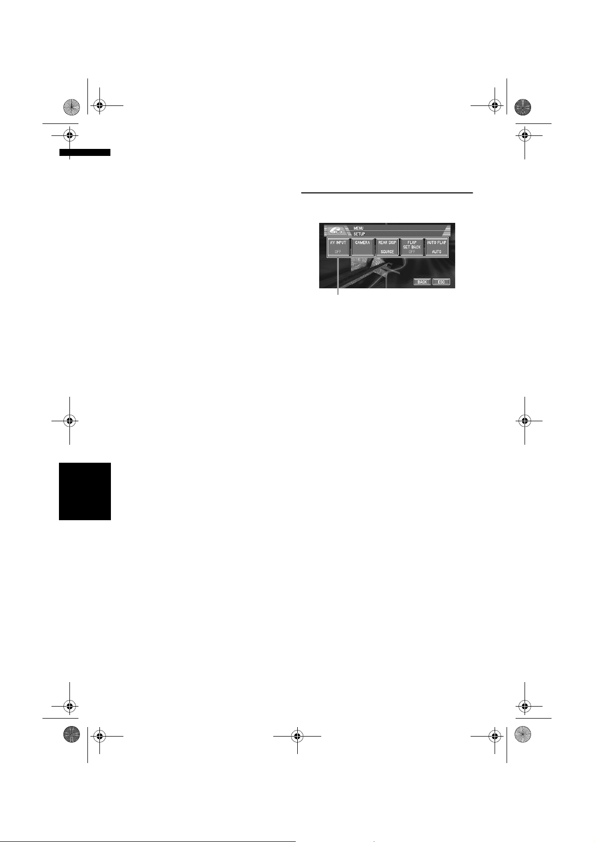
MAN-CNDV-50MT-EN.book Page 96 Wednesday, May 4, 2005 1:49 PM
❒ Operation returns to normal when the
phone connection or the voice guidance is
ended.
❒ Even when you receive a phone call,
navigation voice guidance cannot be
attenuated or muted. Use the Hardware
Volume to control the navigation voice
guidance volume.
Switching the automatic disc
playback
You can turn automatic disc playback on or off
when you insert a disc into the disc loading slot.
When this function is on, the disc will be
automatically played after it is inserted into the
disc loading slot.
Initially, this function is set to OFF.
1 Touch “DISC AUTO” in the INITIAL
menu.
Touching “DISC AUTO” switches between
“ON” and “OFF”.
Switching the dimmer setting
for sub-display
To prevent the sub-display from being too bright
at night, the sub-display is automatically dimmed
when the vehicle’s headlights are turned on. You
Other Functions
can turn dimmer on or off.
1 Touch “SUB. D. DIM” in the INITIAL
menu.
Touching “SUB. D. DIM” switches between
“ON” and “OFF”.
Chapter 8Customising the Audio Source Setting AV
❒ Initially, this function is set to OFF.
Changing the voice output of the
navigation guidance
When there is a navigation guidance, you can
mix the guidance voice/beep sound from a
navigation with the audio sound from this
system. You can select the speaker output the
navigation guidance.
1 Touch “GUIDE VOICE” in the INITIAL
menu.
Each touch of the “GUIDE VOICE” changes
the settings as follows:
96
L+R (Front speakers) – R (Front Right
speaker) – L (Front Left speaker)
Other Functions
Setup adjustments
(1)
(1) Setup menu display
Shows the setup function names.
➲ How to display the SETUP menu ➞ Page 61
Setting the video input
You can switch the setting according to the
connected component.
• Select “VIDEO” to watch video of a connected
component as AV source.
• Select “M-DVD” to watch video of a connected
DVD player as S-DVD source.
1 Touch “AV INPUT” in the SETUP menu.
Each touch of the “AV INPUT” changes the
settings as follows:
• OFF – No video component is connected
• VIDEO – External video component
• M-DVD – DVD player connected with RCA
cable
When a DVD player is connected with an AVBUS cable, do not select “M-DVD” or else no
picture is displayed even if you select S-DVD.
Setting for rear view camera
The navigation unit features a function that
automatically switches to the rear camera image
(REAR VIEW CAMERA IN jack) when a rear view
camera is installed on your vehicle. When the
gearstick is in REVERSE (R) position, the screen
automatically switches to a rear view camera.
(For more details, consult with your dealer.) You
can also use the camera as a rear view camera
(Rear View). In this case, you can see the image
of the rear view camera during normal driving.
Page 99

MAN-CNDV-50MT-EN.book Page 97 Wednesday, May 4, 2005 1:49 PM
(The navigation map screen can be displayed on
the right-hand side and the camera image can be
displayed on the left.) Please beware that in this
setting, camera image is not resized to fit, but
that a portion of what is seen by the camera is not
viewable.
• Pioneer recommends the use of a camera
which outputs mirror reversed images,
otherwise screen image may appear
reversed.
• Confirm the setting immediately whether the
display changes to a rear view camera image
when the gearstick is moved to REVERSE (R)
from another position.
• When the whole screen changes to a rear view
camera image during normal driving, switch to
another setting.
❒ Rear View can be displayed at all times (e.g.
when monitoring an attached trailer, etc.) as a
split screen where map information is partially
displayed. Please beware that in this setting,
camera image is not resized to fit, but that a
portion of what is seen by the camera is not
viewable.
❒ Initially, this function is set to OFF.
1 Touch “CAMERA” in the SETUP menu.
2 Touch “CAMERA” to turn reverse camera
setting on.
Touching “CAMERA” switches between
“ON” and “OFF”.
❒ Unless this setting is “ON”, you cannot
switch to Rear View mode.
3 Touch “POLARITY” to select an
appropriate setting for polarity.
Each time you touch “POLARITY” switches
between the following polarity:
• BATTERY – When the polarity of the
connected lead is positive while the
gearstick is REVERSE (R) position
• GND – When the polarity of the connected
lead is negative while the gearstick is
REVERSE (R) position
Selecting the video of rear
display
When the navigation screen is displayed on front,
you can select either showing the navigation
screen on rear display or the video of the selected
source.
❒ The map screen navigation images output to
the rear display differ from standard NTSC
format images. Therefore, their quality will be
inferior to the images that appear on the front
display.
1 Touch “REAR DISP” in the SETUP menu.
Each touch of the “REAR DISP” changes the
settings as follows:
• SOURCE – Display the screen of the
selected source on rear display
• NAVI – Display the navigation video on
rear display when the navigation screen is
displayed on front
❒ When selecting “SOURCE” in “REAR
DISP”, when the selected source is an
audio source, nothing is displayed on rear
display.
❒ When selecting “SOURCE” in “REAR
DISP”, nothing is displayed on rear
display during a traffic announcement
interruption or a news program
interruption.
❒ When selecting Rear View, nothing is
displayed on the left-hand side of the rear
display.
Setting the slide back function
You can adjust the LCD panel slide position to
prevent the display from hitting the gearstick of
an automatic vehicle when it is in P (park)
position.
❒ Please be careful, as the LCD panel will slide
immediately after the setting is turned “ON”.
1 Touch “FLAP SET BACK” in the SETUP
menu.
Touching “FLAP SET BACK” switches
between “ON” and “OFF”.
Other Functions
Chapter 8 Customising the Audio Source SettingAV
97
Page 100

MAN-CNDV-50MT-EN.book Page 98 Wednesday, May 4, 2005 1:49 PM
Setting the automatic open
function
When you do not wish the display to open/close
automatically, you can set the automatic open
function to the manual mode.
1 Touch “AUTO FLAP” in the SETUP
menu.
Each touch of the “AUTO FLAP” changes
the settings as follows:
• MANUAL – You have to press OPEN/
CLOSE button to open/close the display
• AUTO – The display automatically opens/
closes when power to navigation unit is
turned on
Using the AUX source
An IP-BUS-RCA Interconnector such as the CDRB20/CD-RB10 (sold separately) lets you connect
navigation unit to auxiliary equipment featuring
RCA output. For more details, refer to the IP-BUSRCA Interconnector owner’s manual.
Selecting AUX as the source
1 Touch the source icon and then touch
“AUX” to select AUX as the source.
When the source icon is not displayed, you
can display it by touching the screen.
Switching the Screen Using the DISP Button
If the auxiliary setting is turned “OFF”, “AUX”
cannot be selected.
➲ Switching the auxiliary setting ➞ Page 95
❒ When the AV (Video input) setting is not
set to “VIDEO”, the background display
will not switch to AV (Video input).
➲ Switching the AV input setting ➞ Page 96
❒ Only the REAR ON mode is active, the
background display will switch to DVD
(DVD-Video in the built-in DVD drive).
➲ Using the rear display ➞ “Hardware
Manual”
❒ During the memory navi mode, you cannot
switch to DVD (DVD-Video in the built-in
DVD drive).
Switching the Screen Using the
DISP Button
You can change the screen display using the
DISP button.
(E.g., RADIO)
Preset list
Switching the background
Chapter 8Customising the Audio Source Setting AV
display
You can switch background displays while
listening to each source.
1 Press ENT button.
Each time you press ENT button the display
changes in the following order:
Audio source
• NAVI (Normal wall paper) – AV (Video
input) – DVD (DVD-Video in the built-in
DVD drive)
Video source
• Video of currently selected source – NAVI
(Normal wall paper) – AV (Video input) –
DVD (DVD-Video in the built-in DVD drive)
98
Information plate
❒ You cannot switch the screen display with the
DISP button for the following sources.
S-DVD (Source DVD), AV, AUX, EXT
❒ The indication of the information plate will be
switched for the items marked with asterisk
(*).
RADIO
Preset list – list off (Information plate only)
 Loading...