

Page 1
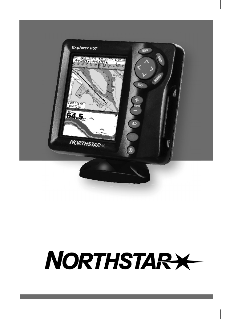
Explorer 657
Fishfi nder and Chartplotter
Installation and Operation Manual
www.northstarnav.com
Page 2
DANGER
!
WARNING
!
CAUTION
CAUTION
IMPORTANT SAFETY INFORMATION
Please read carefully before installation and use.
This is the safety alert symbol. It is used to alert you to potential personal
injury hazards, Obey all safety messages that follow this symbol to avoid
possible injury or death.
WARNING indicates a potentially hazardous situation which, if not avoided,
could result in death or serious injury
CAUTION indicates a potentially hazardous situation which, if not avoided,
could result in minor or moderate injury.
CAUTION used without the safety alert symbol indicates a potentially
hazardous situation which, if not avoided, may result in property
damage.
DISCLAIMER: It is the owner’s sole
responsibility to install and use the instrument
and transducers in a manner that will not cause
accidents, personal injury or property damage.
The user of this product is solely responsible for
observing safe boating prac tices.
BRUNSWICK NEW TECHNOLOGIES INC. AND ITS
SUBSIDIARIES AND AFFILIATES DISCLAIM ALL
LIABILIT Y FOR ANY USE OF THIS PRODUCT IN A
WAY THAT MAY CAUSE ACCIDENTS, DAMAGE OR
THAT MAY VIOLATE THE LAW.
Governing Language: This statement,
any instruction manuals, user guides and
other information relating to the product
(Documentation) may be translated to, or
has been translated from, another language
(Translation). In the event of any conf lict
between any Translation of the Documentation,
the English language version of the
Documentation will be the official version of the
Documentation.
This manual represents the Explorer 657
as at the time of printing. Brunswick New
Technologies Inc. and its subsidiaries and
affiliates reserve the right to make changes to
specifications without notice.
Copyright © 2006 Brunswick New Technologies
Inc. Northstar™ is a registered trademark of
Brunswick New Technologies Inc
FCC Statement
Note: This equipment has been tested and found to comply with the limits for a Class B digital device,
pursuant to Part 15 of the FCC Rules. These limits are designed to provide reasonable protection
against harmful interference in a normal installation. This equipment generates, uses and can radiate
radio frequency energy and, if not installed and used in accordance with the instructions, may cause
harmful interference to radio communications. However, there is no guarantee that interference
will not occur in a particular installation. If this equipment does cause harmful interference to radio
or television reception, which can be determined by turning the equipment off and on, the user is
encouraged to try to correct the interference by one or more of the following measures:
Reorient or relocate the receiving antenna.
Increase the separation between the equipment and receiver.
Connect the equipment into an output on a circuit different from that to which the receiver is
connected.
Consult the dealer or an experienced technician for help.
A shielded cable must be used when connecting a peripheral to the serial ports.
Page 3

Important
The choice, location, angle and installation
of the instrument & transducers are critical to
performance of the system as intended. Follow
instructions in this manual carefully. If in doubt,
consult your Northstar dealer.
Ensure that any holes cut are in a safe position and
will not weaken the boat’s structure. If in doubt,
consult a qualified boat builder.
Do not install plastic through hull transducers in
solid wooden hulls. Leaking through the hull may
result.
Do not install bronze transducers in metal hulls.
This will cause electrolytic corrosion that may
result in damage to the hull or transducer.
Sonar Performance: The accuracy of the sonar
depth display can be affected by many factors,
including the type and location of the transducer
and water conditions. Ensure that the transducer is
located and used correctly.
Global Positioning System: The Global
Positioning System (GPS) is operated by the
US Government which is solely responsible for
its operation, accuracy and maintenance. The
GPS system is subject to changes which could
affect the accuracy and performance of all GPS
equipment anywhere in the world including
the 657. Whilst the Northstar 657 is a precision
navigation instrument, it can be misused or
misinterpreted, which can result in its use
being unsafe. To reduce the risk of misusing or
misinterpreting the 657, the user must read and
understand all aspects of this Installation and
Operation manual. We also suggest that the user
practice all operations using the built in simulator
before using the 657 at sea.
Electronic Chart: The electronic chart used by
the 657 is an aid to navigation and is designed to
supplement the use of official government charts
not replace them. Only official government charts
supplemented by notices to mariners contain
the information required for safe and prudent
navigation. Always supplement the information
provided by the 657 with other plotting sources
such as observations, depth soundings, radar and
hand compass bearings. Should the information
not agree then the discrepancy must be resolved
before proceeding any further.
Sonar fishfinder: The accuracy of the sonar
depth display can be limited by many factors,
including the type of the transducers, the location
of the transducers and water conditions. It is the
user’s responsibility to ensure the 657 transducers
are installed and used correctly.
AIS: The AIS features on this chart-plotter are
designed as a safety aid only and do not guarantee
safety at sea. AIS transmission is mandatory on
some, but not all, vessels. You should check your
local laws and regulations for requirements in your
area. As a result of different legal requirements,
different vessel sizes and uses, you should not
assume that your AIS equipped chart-plotter will
show the location of ALL vessels in your area.
Careful prudence, judgement, and safe navigation
practices should always be exercised. AIS should
be used to complement radar, but AIS is not a
substitute for radar.
Fuel Computer: Fuel economy can alter
drastically depending on the boat loading and sea
conditions. The fuel computer should not be the
sole source of information concerning available
fuel onboard and the electronic information
should be supplemented by visual or other checks
of the fuel load. This is necessary due to possible
operator induced errors such as forgetting to
reset the fuel used when filling the tank, running
the engine with the fuel computer not switched
on or other operator controlled actions that may
render the device inaccurate. Always ensure that
adequate fuel is carried onboard for the intended
trip plus a reserve to allow for unforeseen
circumstances.
Failure to adhere to these warnings may
lead to death, serious injury or property
damage. Northstar disclaims all liability for
installation or use of this product that causes
or contributes to death, injury or property
damage or that violates any law.
The 657 is set up with default units of feet, °F
(Fahrenheit), US gallons and knots. To change the
units, see section 17-10.
3Northstar Explorer 657 Installation and Operation Manual
Page 4
Contents
1 Introdu ction ......................................................................................................................................... 7
1-1 Overview . . . . . . . . . . . . . . . . . . . . . . . . . . . . . . . . . . . . . . . . . . . . . . . . . . . . . . . . . . . . . . . . . . . . . . . . . 8
1-2 Cleaning and maintenance . . . . . . . . . . . . . . . . . . . . . . . . . . . . . . . . . . . . . . . . . . . . . . . . . . . . . . . 8
1-3 Plug-in cards . . . . . . . . . . . . . . . . . . . . . . . . . . . . . . . . . . . . . . . . . . . . . . . . . . . . . . . . . . . . . . . . . . . . . 8
1-4 Removing and replacing the display unit . . . . . . . . . . . . . . . . . . . . . . . . . . . . . . . . . . . . . . . . . 9
2 Basic Op eration .................................................................................................................................... 10
2-1 Using the keys . . . . . . . . . . . . . . . . . . . . . . . . . . . . . . . . . . . . . . . . . . . . . . . . . . . . . . . . . . . . . . . . . . .10
2-2 Turning on and off / auto power . . . . . . . . . . . . . . . . . . . . . . . . . . . . . . . . . . . . . . . . . . . . . . . . . 11
2-3 Backlight and night mode . . . . . . . . . . . . . . . . . . . . . . . . . . . . . . . . . . . . . . . . . . . . . . . . . . . . . . . 12
2-4 Man overboard (MOB) . . . . . . . . . . . . . . . . . . . . . . . . . . . . . . . . . . . . . . . . . . . . . . . . . . . . . . . . . . . 12
2-5 Alarms . . . . . . . . . . . . . . . . . . . . . . . . . . . . . . . . . . . . . . . . . . . . . . . . . . . . . . . . . . . . . . . . . . . . . . . . . . . 13
2-6 Simulate mode . . . . . . . . . . . . . . . . . . . . . . . . . . . . . . . . . . . . . . . . . . . . . . . . . . . . . . . . . . . . . . . . . . 13
2-7 The main windows . . . . . . . . . . . . . . . . . . . . . . . . . . . . . . . . . . . . . . . . . . . . . . . . . . . . . . . . . . . . . .14
3 Navigati on: Chart ................................................................................................................................. 19
3-1 Introduction to navigating . . . . . . . . . . . . . . . . . . . . . . . . . . . . . . . . . . . . . . . . . . . . . . . . . . . . . . . 19
3-2 Chart window . . . . . . . . . . . . . . . . . . . . . . . . . . . . . . . . . . . . . . . . . . . . . . . . . . . . . . . . . . . . . . . . . . . 21
3-3 Distance and bearing calculator . . . . . . . . . . . . . . . . . . . . . . . . . . . . . . . . . . . . . . . . . . . . . . . . . 23
3-4 Projected course . . . . . . . . . . . . . . . . . . . . . . . . . . . . . . . . . . . . . . . . . . . . . . . . . . . . . . . . . . . . . . . .23
3-5 Tracks and tracking . . . . . . . . . . . . . . . . . . . . . . . . . . . . . . . . . . . . . . . . . . . . . . . . . . . . . . . . . . . . . .24
4 Navigation: Highway w indow .............................................................................................................. 24
5 Navigati on: Waypoints ......................................................................................................................... 25
5-1 Waypoints window . . . . . . . . . . . . . . . . . . . . . . . . . . . . . . . . . . . . . . . . . . . . . . . . . . . . . . . . . . . . . .25
5-2 Managing waypoints . . . . . . . . . . . . . . . . . . . . . . . . . . . . . . . . . . . . . . . . . . . . . . . . . . . . . . . . . . . . 26
6 Navigati on: Routes .............................................................................................................................. 27
6-1 Routes window . . . . . . . . . . . . . . . . . . . . . . . . . . . . . . . . . . . . . . . . . . . . . . . . . . . . . . . . . . . . . . . . . .28
6-2 Managing routes . . . . . . . . . . . . . . . . . . . . . . . . . . . . . . . . . . . . . . . . . . . . . . . . . . . . . . . . . . . . . . . .28
7 Satelli tes ............................................................................................................................................. 30
7-1 Satellite window . . . . . . . . . . . . . . . . . . . . . . . . . . . . . . . . . . . . . . . . . . . . . . . . . . . . . . . . . . . . . . . . .31
8 Sonar f ishfinding : Introductio n ........................................................................................................... 31
8-1 Using the 657 . . . . . . . . . . . . . . . . . . . . . . . . . . . . . . . . . . . . . . . . . . . . . . . . . . . . . . . . . . . . . . . . . . . . 31
8-2 Interpreting the display . . . . . . . . . . . . . . . . . . . . . . . . . . . . . . . . . . . . . . . . . . . . . . . . . . . . . . . . . . 32
8-3 Single and Dual frequency fishfinding . . . . . . . . . . . . . . . . . . . . . . . . . . . . . . . . . . . . . . . . . . . 34
Northstar Explorer 657 Installation and Operation Manual4
Page 5

8-4 Fish detection and display . . . . . . . . . . . . . . . . . . . . . . . . . . . . . . . . . . . . . . . . . . . . . . . . . . . . . . . 37
8-5 Range . . . . . . . . . . . . . . . . . . . . . . . . . . . . . . . . . . . . . . . . . . . . . . . . . . . . . . . . . . . . . . . . . . . . . . . . . . . 38
8-6 Gain and threshold . . . . . . . . . . . . . . . . . . . . . . . . . . . . . . . . . . . . . . . . . . . . . . . . . . . . . . . . . . . . . .39
9 Sonar f ishfinding : Displays .................................................................................................................. 40
9-1 Sonar history display - no split . . . . . . . . . . . . . . . . . . . . . . . . . . . . . . . . . . . . . . . . . . . . . . . . . .40
9-2 Sonar Zoom and Full Screen Zoom displays . . . . . . . . . . . . . . . . . . . . . . . . . . . . . . . . . . . . . 41
9-3 Sonar Bottom display . . . . . . . . . . . . . . . . . . . . . . . . . . . . . . . . . . . . . . . . . . . . . . . . . . . . . . . . . . . . 42
9-4 Sonar 50/200 display . . . . . . . . . . . . . . . . . . . . . . . . . . . . . . . . . . . . . . . . . . . . . . . . . . . . . . . . . . . . 42
9-5 Sonar A-Scope display . . . . . . . . . . . . . . . . . . . . . . . . . . . . . . . . . . . . . . . . . . . . . . . . . . . . . . . . . .43
10 Gauges window .................................................................................................................................. 44
11 Data window ......................................................................................................................................4 4
12 Fuel functi ons and display .................................................................................................................. 45
12-1 What the fuel computer does . . . . . . . . . . . . . . . . . . . . . . . . . . . . . . . . . . . . . . . . . . . . . . . . . . .45
12-2 Fuel window . . . . . . . . . . . . . . . . . . . . . . . . . . . . . . . . . . . . . . . . . . . . . . . . . . . . . . . . . . . . . . . . . . .45
12-3 When you add or remove fuel . . . . . . . . . . . . . . . . . . . . . . . . . . . . . . . . . . . . . . . . . . . . . . . . . . 46
12-4 Low fuel alarm . . . . . . . . . . . . . . . . . . . . . . . . . . . . . . . . . . . . . . . . . . . . . . . . . . . . . . . . . . . . . . . . .47
12-5 Boat speed sensors . . . . . . . . . . . . . . . . . . . . . . . . . . . . . . . . . . . . . . . . . . . . . . . . . . . . . . . . . . . . . 47
12-6 Fuel consumption curves . . . . . . . . . . . . . . . . . . . . . . . . . . . . . . . . . . . . . . . . . . . . . . . . . . . . . . . 49
12-7 Calibration . . . . . . . . . . . . . . . . . . . . . . . . . . . . . . . . . . . . . . . . . . . . . . . . . . . . . . . . . . . . . . . . . . . . .51
13 Tides window ..................................................................................................................................... 52
14 User card wi ndow ............................................................................................................................... 53
15 AIS ..................................................................................................................................................... 54
15-1 Viewing AIS Vessels . . . . . . . . . . . . . . . . . . . . . . . . . . . . . . . . . . . . . . . . . . . . . . . . . . . . . . . . . . . .55
15-2 Dangerous Vessels . . . . . . . . . . . . . . . . . . . . . . . . . . . . . . . . . . . . . . . . . . . . . . . . . . . . . . . . . . . . . 55
15-3 AIS Windows . . . . . . . . . . . . . . . . . . . . . . . . . . . . . . . . . . . . . . . . . . . . . . . . . . . . . . . . . . . . . . . . . . .56
16 DSC/Budd y track windows .................................................................................................................. 57
16-1 The displays . . . . . . . . . . . . . . . . . . . . . . . . . . . . . . . . . . . . . . . . . . . . . . . . . . . . . . . . . . . . . . . . . . . .57
16-2 Using the displays . . . . . . . . . . . . . . . . . . . . . . . . . . . . . . . . . . . . . . . . . . . . . . . . . . . . . . . . . . . . . .58
17 Setting up t he 657 .............................................................................................................................. 59
17-1 Setup > System . . . . . . . . . . . . . . . . . . . . . . . . . . . . . . . . . . . . . . . . . . . . . . . . . . . . . . . . . . . . . . . . 61
17-2 Setup > Chart . . . . . . . . . . . . . . . . . . . . . . . . . . . . . . . . . . . . . . . . . . . . . . . . . . . . . . . . . . . . . . . . . .62
17-3 Setup > Sonar . . . . . . . . . . . . . . . . . . . . . . . . . . . . . . . . . . . . . . . . . . . . . . . . . . . . . . . . . . . . . . . . . . 65
17-4 Setup > GPS . . . . . . . . . . . . . . . . . . . . . . . . . . . . . . . . . . . . . . . . . . . . . . . . . . . . . . . . . . . . . . . . . . .66
5Northstar Explorer 657 Installation and Operation Manual
Page 6
17-5 Setup > Fuel . . . . . . . . . . . . . . . . . . . . . . . . . . . . . . . . . . . . . . . . . . . . . . . . . . . . . . . . . . . . . . . . . . .66
17-6 Setup > Track . . . . . . . . . . . . . . . . . . . . . . . . . . . . . . . . . . . . . . . . . . . . . . . . . . . . . . . . . . . . . . . . . . .68
17-7 Setup > AIS . . . . . . . . . . . . . . . . . . . . . . . . . . . . . . . . . . . . . . . . . . . . . . . . . . . . . . . . . . . . . . . . . . . . .69
17-8 Setup > Logs . . . . . . . . . . . . . . . . . . . . . . . . . . . . . . . . . . . . . . . . . . . . . . . . . . . . . . . . . . . . . . . . . . .69
17-9 Setup > Alarms . . . . . . . . . . . . . . . . . . . . . . . . . . . . . . . . . . . . . . . . . . . . . . . . . . . . . . . . . . . . . . . . .70
17-10 Setup > Units . . . . . . . . . . . . . . . . . . . . . . . . . . . . . . . . . . . . . . . . . . . . . . . . . . . . . . . . . . . . . . . . . . 71
17-11 Setup > Comms . . . . . . . . . . . . . . . . . . . . . . . . . . . . . . . . . . . . . . . . . . . . . . . . . . . . . . . . . . . . . . . 71
17-12 Setup > Calibrate . . . . . . . . . . . . . . . . . . . . . . . . . . . . . . . . . . . . . . . . . . . . . . . . . . . . . . . . . . . . . .72
17-13 Setup > Time . . . . . . . . . . . . . . . . . . . . . . . . . . . . . . . . . . . . . . . . . . . . . . . . . . . . . . . . . . . . . . . . .73
17-14 Setup > Favorites . . . . . . . . . . . . . . . . . . . . . . . . . . . . . . . . . . . . . . . . . . . . . . . . . . . . . . . . . . . . .73
17-15 Setup > Simulate . . . . . . . . . . . . . . . . . . . . . . . . . . . . . . . . . . . . . . . . . . . . . . . . . . . . . . . . . . . . . 74
18 Installa tion ....................................................................................................................................... 74
18-1 Installation: What comes with the 657 . . . . . . . . . . . . . . . . . . . . . . . . . . . . . . . . . . . . . . . . . . 75
18-2 Installation: Options and Accessories . . . . . . . . . . . . . . . . . . . . . . . . . . . . . . . . . . . . . . . . . . .75
18-3 Installation: The display unit . . . . . . . . . . . . . . . . . . . . . . . . . . . . . . . . . . . . . . . . . . . . . . . . . . . .77
18-4 Installation: Power/data cable . . . . . . . . . . . . . . . . . . . . . . . . . . . . . . . . . . . . . . . . . . . . . . . . . .78
18-5 Installation: GPS antenna . . . . . . . . . . . . . . . . . . . . . . . . . . . . . . . . . . . . . . . . . . . . . . . . . . . . . .79
18-6 Installation: Sonar transducer . . . . . . . . . . . . . . . . . . . . . . . . . . . . . . . . . . . . . . . . . . . . . . . . . .80
18-7 Installation: Northstar petrol/gasoline sensors . . . . . . . . . . . . . . . . . . . . . . . . . . . . . . . . . . 80
18-8 Installation: SmartCraft™ . . . . . . . . . . . . . . . . . . . . . . . . . . . . . . . . . . . . . . . . . . . . . . . . . . . . . . . 81
18-9 Installation: Other NavBus instruments . . . . . . . . . . . . . . . . . . . . . . . . . . . . . . . . . . . . . . . . . 81
18-10 Installation: Other NMEA instruments . . . . . . . . . . . . . . . . . . . . . . . . . . . . . . . . . . . . . . . . . 82
18-11 Installation: Setup and test . . . . . . . . . . . . . . . . . . . . . . . . . . . . . . . . . . . . . . . . . . . . . . . . . . . . 83
Append ix A - Specifica tions .....................................................................................................................8 4
Append ix B - Troubleshootin g ................................................................................................................. 86
B-1 General problems . . . . . . . . . . . . . . . . . . . . . . . . . . . . . . . . . . . . . . . . . . . . . . . . . . . . . . . . . . . . . . . 86
B-2 GPS navigation problems . . . . . . . . . . . . . . . . . . . . . . . . . . . . . . . . . . . . . . . . . . . . . . . . . . . . . . . .87
B-3 Fuel consumption problems . . . . . . . . . . . . . . . . . . . . . . . . . . . . . . . . . . . . . . . . . . . . . . . . . . . . .87
B-4 Sonar fishfinding problems . . . . . . . . . . . . . . . . . . . . . . . . . . . . . . . . . . . . . . . . . . . . . . . . . . . . .88
Append ix C - Glossary an d navigation data ..............................................................................................90
Northstar Explorer 657 Installation and Operation Manual6
Page 7

1 Introduction
Quick reference to the built-in and optional features:
Feature Type See Requires
General How to use the keys and displays 2
Troubleshooting Appendix B
Simulate mode 2-6
Glossary of special names Appendix C
Specifi cations Appendix A
MOB Man overboard key 2-4
Navigation Overview of how to navigate 3-1 GPS fi x
Finding the boat’s position on the chart 3-2
Navigate to any point or to a waypoint 3-1
Navigate along a route 3-1
Projected course: An estimate of progress 3-4
Tracks: records of where the boat has been 3-5
GPS receiver status 7
Saving and loading data with a user card 14 User card
Chart data Chart features (built in world chart) 3-2
Chart details 3-2-4 & 5 C-MAP™ chart
Tides at a port 11 C-MAP™ chart
AIS 15
Alarms Built in alarms 2-5
SmartCraft™ engine alarms 1-1 SmartCraft™
Boat data Data at top of main displays 2-7-3
Compass at top of main displays 2-7-4
Dedicated data window 11
Fuel Fuel computer, petrol/gasoline engine 12 Fuel sensors
Fuel computer, SmartCraft™ engines 12 SmartCraft™
What to do when you add or remove fuel 12-1
Sounder Overview of the depth sounder
Depth, bottom features, water features
Fishfi nder
Other boats Track your buddy, polling other boats
Distress calls
8
8
8
16
16
Sounder
Sounder
Sounder
DSC VHF
DSC VHF
7Northstar Explorer 657 Installation and Operation Manual
Page 8

1-1 Ov ervi ew
The Northstar 657 is a compact, rugged, highly
integrated marine chartplotter and fishfinder. It is
easy to use and has an easy to read color display.
Complex functions can be per formed with a few
key presses, taking the hard work out of boating.
The available functions, displays and setup
menus depend on the optional sensors and
instruments that are installed:
Sonar functions require a sonar transducer to
be installed
Fuel functions require one or more
petrol/gasoline or diesel fuel sensors to be
installed.
SmartCraft™ engine functions require a
SmartCraft™ system to be installed. For
information on using SmartCraft™, see the
SmartCraf t™ Gateway Installation and
Operation Manual.
1-2 Cleaning and main tenance
The 657 screen is covered by a proprietary
anti-reflection coating. To avoid damage, clean
the screen only with a damp cloth and mild
detergent when dirty or covered in sea salt.
Avoid abrasive cleaners, petrol or other solvents.
If a plug-in card gets dir ty or wet, clean it with a
damp cloth or mild detergent.
Cover or remove a transom-mounted transducer
when repainting the hull. If painting over a
through hull transducer with antifouling paint,
DSC/Buddy track functions require a
Northstar DSC VHF radio with Buddy track
support to be installed.
The 657 can send data to other instruments,
such as an autopilot, and receive data from
other instruments.
AIS functions require an optional AIS receiver
to be installed.
For information on installing options, see section
18-2 .
This manual describes how to install and operate
the 657. Special terms are explained in Appendix
C. For maximum benefit, please read this manual
carefully before installing and using the unit. For
more information on this instrument and other
Northstar products, go to our website,
www.northstarnav.com.
use only one coat of paint. Remove the previous
coat of antifouling paint by sanding it lightly.
To optimize per forman ce, avoid w alking o n
or jamming cables and connectors. Keep the
transducer free of weed, paint and debris. Do not
use a high pressure water blast on a speed sensor
paddlewheel as it may damage the bearings.
Push the dust cover over the display when the
657 is turned of f.
1-3 Plug-in cards
The 657 can use two kinds of plug-in card:
1 C-MAP™ chart cards have chart details
required for navigating in a particular region.
When a chart card is plugged in, the extra
details automatically appear on the 657 chart
window.
The 657 can use NT, NT+ and NT-MAX
cards. NT-MAX cards have much more chart
information than earlier cards, including
photos of points of interest.
Northstar Explorer 657 Installation and Operation Manual8
2 C-MAP™ user cards are used to store
navigation data. Each user card expands
the 657 memory and allows the data to be
transferred to another 657 easily.
(see section 14).
Note: The older 5 volt user cards are not
supported.
Page 9
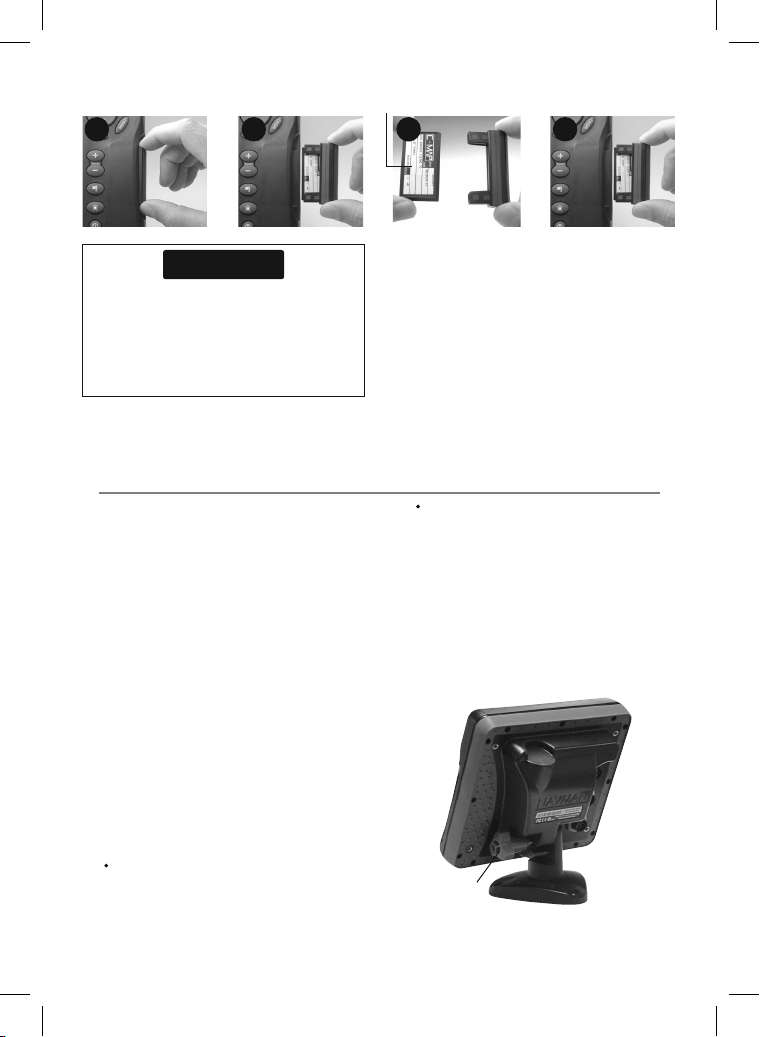
Changing the p lug-in card
Gold contacts under here
1 2 4
3
Card
Holder
CAUTION
Handle plug-in cards carefully. Keep them in
their protective cases when not plugged into
the 657.
Keep the holder in place in the 657 at all times
to prevent moisture from entering the card
compartment.
1-4 Removing and re placing the display u nit
If the display unit is bracket mounted then the
display unit can easily be removed and replaced
for security or protec tion.
Removing the dis play unit:
1 Turn the display unit of f (see section 2-2) and
put the dust cover on.
2 Loosen the knob on the mounting bracket
and lift the unit off the bracket.
3 Unplug the connectors from the display unit;
turning each locking collar anticlock wise until
you can pull the plug out.
4 Push the attached dust covers over the
exposed ends of the connectors.
5 Store the display unit in a dry clean place,
such as the optional Northstar carr y bag.
Replacing the d isplay unit
1 Remove the dust covers from the connectors.
Plug the connectors into the back of the
display unit:
Match the connector’s color to the socket
color.
Turn the 657 off (see section 2-2).
Pull the card holder out of the 657 and pull any
card out of holder.
Put the card in its case.
Push new card into holder. Ensure the gold
contacts are on the outer edge and underneath
(see above).
Keep the card’s case.
Push card holder fully into 657
Insert each connector and turn the
locking collar clockwise until it is finger
tight.
Nothing will be damaged if a cable is
plugged into the wrong socket by mistake.
2 Hold the display unit in place on the
mounting bracket. Adjust the tilt of the
display for best viewing, then hand tighten
the knob on the mounting bracket. Remove
the dust cover.
Mounting
Knob
bracket
9Northstar Explorer 657 Installation and Operation Manual
Page 10
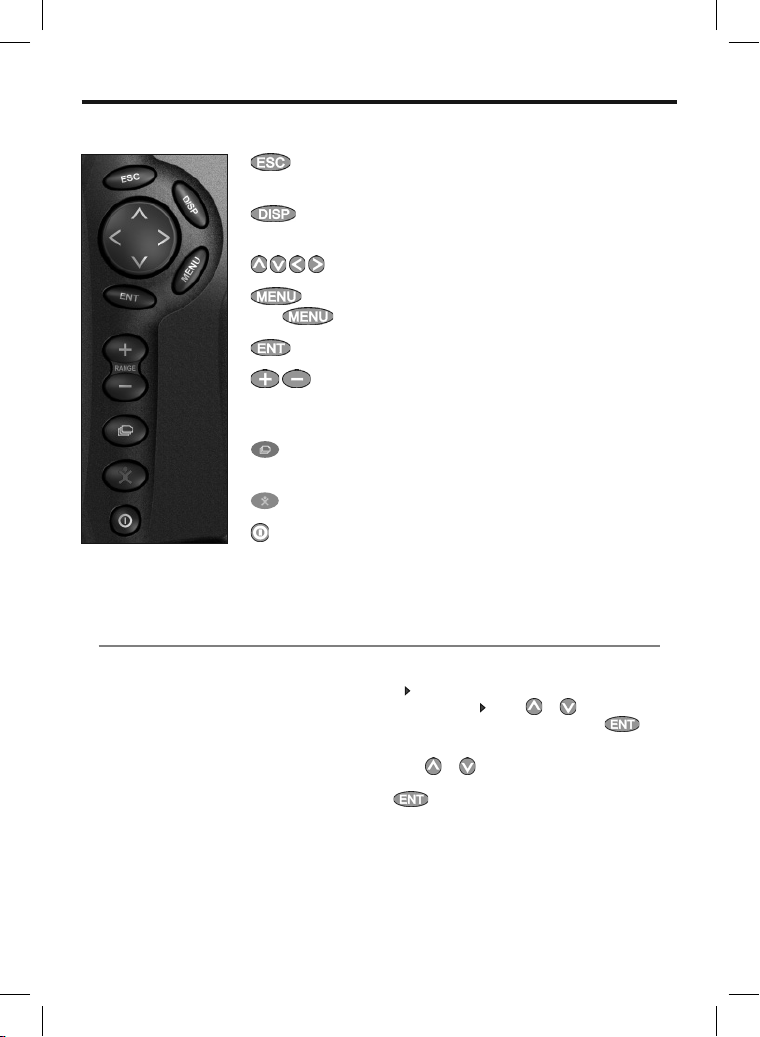
2 Basic Operation
Overview of the keys
2-1 Using the keys
ESCAPE - Go back to an earlier menu or display. In chart mode,
centres chart at boat’s position.
DISPLAY - Show a menu of the main displays. To go to a display,
select it from the menu (see section 2-7).
CURSOR KEYS - to move the cursor or the selection highlight.
MENU - Show a menu of the options for the current window.
Press
areas and detail on the chart.
Sonar window: Change the depth range displayed.
favorite displays.
POWER - Turn 657 on and off (see section 2-2); adjust the backlighting
(see section 2-3).
again to display the Setup menu (see section 17).
ENTER - Start an action or accept a change.
ZOOM - Chart window: Zoom in or out to display different
FAVORITES - Allows you to quickly switch between your saved
MOB - (Man Overboard, see section 2-4).
In this manual:
Press means to push the key for less than a
second.
Hold means to hold the key down.
The internal beeper beeps when a key is pressed
(to disable or enable the beep, see section 17-1).
Using the menu s
Operate the 657 by selecting items from menus.
Items can be submenus, commands or data.
Northstar Explorer 657 Installation and Operation Manual10
Selecting a submenu
after a menu item indicates a submenu, for
A
example Chart
highlight to the submenu, then press .
Starting a command
Press or to move the highlight to the
command, for example Goto cursor, then press
. Press or to move the
.
Page 11
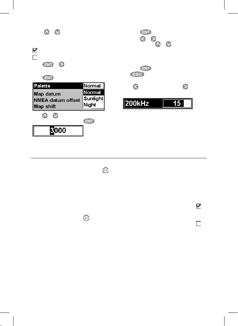
Changing data
First press
data to change, then:
a) To change a tick box
means Off or No.
Press
b) To select an option
1 Press
2 Press or to move the highlight to the
or to move the highlight to the
means On or Yes
or to change the tick box.
to display the menu of options.
option you want, then press .
2-2 Turning on and o ff / auto power
Turning on manual ly
If the 657 is not wired for auto power, press to
turn the unit on. If necessary, adjust the display to
be easy to read (see section 2-3).
Note: If the 657 is not wired for auto power then
the 657 does not record engine hours and might
not record fuel consumption (see section 18-4).
Turning off ma nually
If the 657 is not wired for auto power or if the
ignition switch is off, hold down until the
display turns off.
c) To change a name or number:
1 Press
2 Press
change. Press
digit.
Repeat this to change other letters or
numbers.
3 Press
d ) To change a slider value
Press
the value.
to display the name or number:
or to select a letter or digit to
or to change the letter or
to accept the new value. Or press
to ignore the changes.
to decrease the value or to increase
Auto power
If the 657 is wired for auto power (see section
18- 4), t hen:
• The 657 automatically turns on when you turn
the boat’s ignition switch on.
• You can not turn the 657 off while the
ignition switch is on.
• If Auto power off (see section 17-1) is
657 automatically turns off when you turn the
boat’s ignition switch of f.
• If Auto power off (see section 17-1) is
, the 657 stays on when you turn the boat’s
ignition switch off. You can now turn the 657
off manually.
, the
11Northstar Explorer 657 Installation and Operation Manual
Page 12
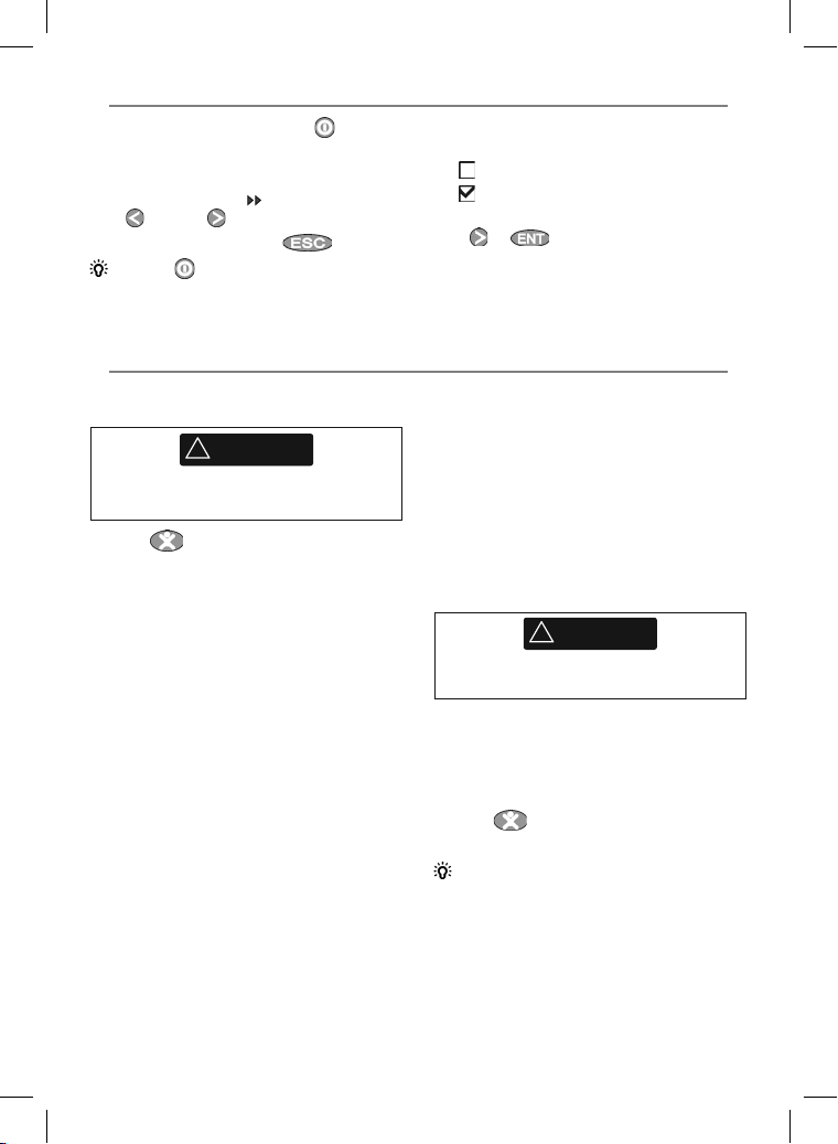
2-3 Backlight and nigh t mode
To go to the Backlight display, press briefly.
Backlight
The display and keys are backlit. To change the
backlight level, highlight select Backlight, then
press to dim or to brighten.
When you have finished, press
Tip: Press twice to give the brightest
screen, with maximum backlight and Night mode
off.
2-4 Man overboard ( MOB)
The MOB feature saves the boat’s position and
then navigates back to this point.
!
WARNING
MOB will not work if the 657 does not have
a GPS fix.
1 Press
The 657 stores the boat’s position as a
waypoint called MOB.
2 The 657 changes to the chart window, with
the MOB waypoint at the center of the chart.
The chart zooms in for accurate navigation.
If the chart can not show the required small
scale, the 657 changes to plotter mode (a
white display with crosshatching and no
chart details, see section 17-2).
3 The 657 sets the MOB waypoint to be the
destination to navigate to.
If the NMEA out put (autopilot) is off
(see section 17-11) use the 657 to manually
navigate to the destination MOB waypoint
(see sections 3-1-1 and 3-1-2).
.
Night mode
Night mode sets the palette for all displays.
Normal palette, for day time
A palette optimised for night time.
To change mode, highlight Night mode, then
press
or . To change only the chart
palette, see section 17-2.
If the NMEA out put (autopilot) is on, the
657 asks if the autopilot is active.
Select:
No: Use the 657 to manually navigate to the
destination MOB waypoint (see sections
3-1-1 and 3-1-2).
Yes : The 657 asks if the boat is to go to the
MOB waypoint.
Select:
Ye s: to immediately start navigating to
the MOB waypoint.
!
WARNING
This might result in a sudden and dangerous
turn.
No: disengage the autopilot; then use
the 657 to manually navigate to the
destination MOB waypoint (see sections
3-1-1 and 3-1-2).
To cancel MOB o r set another MO B
1 Press
2 Select an option from the menu.
Tip: The MOB waypoint remains on the chart
after the MOB has been cancelled. To delete the
MOB waypoint, see section 5-2-5.
again to display a menu.
Northstar Explorer 657 Installation and Operation Manual12
Page 13
2-5 Al arms
When the 657 detects an alarm condition, it
displays a warning message on the display, the
internal beeper sounds and any external beepers
or lights operate.
Press to clear the alarm. The alarm will
sound again if the alarm condition occurs again.
The 657 has user set table alarms (see sec tion
17- 9) .
2-6 Simulate mo de
In Simulate mode, the 657 ignores data from the
GPS antenna and other transducers and sensors
and the 657 generates this data itself. Other wise,
the 657 functions normally.
There are two simulate modes:
• Normal : Allows a user to become familiar with
the 657 off the water.
• Demo: Simulates a boat moving along a
route and automatically displays different 657
functions.
To start and stop Simulate mode, and for more
information, see section 17-15. In simulate mode,
Simulate or Demo f lashes at the bottom of the
display.
!
WARNING
Never have Simulate mode on when the 657
is navigating on the water.
13Northstar Explorer 657 Installation and Operation Manual
Page 14

2-7 The main windows
The display menu allows quick access to the main
windows. Full-screen Char t and Sonar are at the
top of the menu. O ther windows are available
More… sub menu.
from the
Note
1 The windows available depend
on the optional sensors and
instrument s that are installed
(see section 1-1).
2 Set up commonly used windows
as favorites and press
switch bet ween windows (see
section 2-7-2).
to
Northstar Explorer 657 Installation and Operation Manual14
Page 15
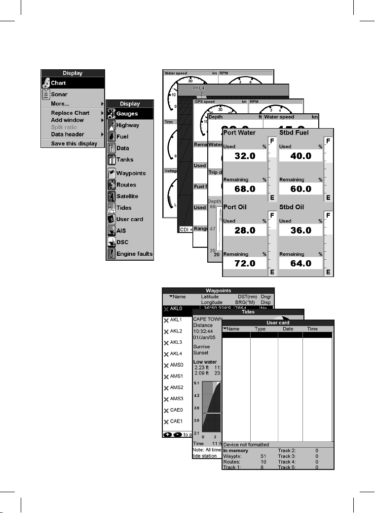
Note: The windows below the menu divider can
only be shown full screen without a data header.
(see section 2-7-3).
15Northstar Explorer 657 Installation and Operation Manual
Page 16
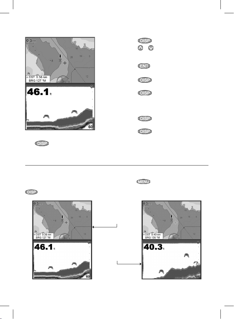
2-7-1 Multi window displays
The 657 can show two windows at once.
Adding a window to the display
Press , select Add window and select a
window to add. The 657 automatically rearranges
the display to show the new window.
The active window
If there is more than one window displayed, the
active window is indicated by a red border. Press
twice to change the active window.
Changing window size
1 Press
2 Press or to change the height of the
windows.
Note: Some windows are fixed in size.
3 Press .
Exchanging two windows on the display
1 Press
window.
2 Press , select Replace and select the
second window.
The 657 exchanges the two windows.
Replacing a window on the display
1 Press
window.
2 Press , select Replace and select a
new window that is not currently visible.
Note:
When some windows are small then not all the
data is shown.
Pressing will display the options menu for
the active window.
and select Split ratio.
twice to change the active
twice to change the active
Chart is active
Red border
Sonar is active
Red border
Northstar Explorer 657 Installation and Operation Manual16
Page 17
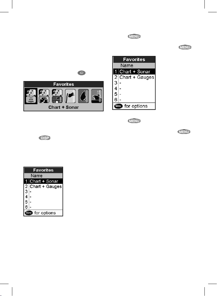
2-7-2 Favorite displays
The 657 has a list of commonly used displays,
called favorite displays. T here can be up to six
favorite displays.
Sonar, Gauges, Fuel, Data, and Tanks windows can
be combined in a display. Each of these displays
can have a data header (see sec tion 2-7-3) and a
compass (see section 2-7-4).
Selecting a favorite display
To select another favourite, press
more times. For example, with six favourites:
one or
Deleting a favorite display from the list
1 Press
Favorites.
2 Highlight the display to delete, press
and select Delete.
twice then select
Adding a favorite display to the list
1 Set up the display with the window or
windows you want in the new favorite (see
section 2-7).
2 Press
display. The 657 displays the favorites list.
3 Select where in the list to add the new
favorite. If you select an existing favorite
display then the new favorite will replace the
existing favorite in the list.
and selec t Save this
Changing the order of the favorites list
1 Press
Favorites.
2 Highlight the display to move, press
and select Move up or Move down.
twice then select
17Northstar Explorer 657 Installation and Operation Manual
Page 18
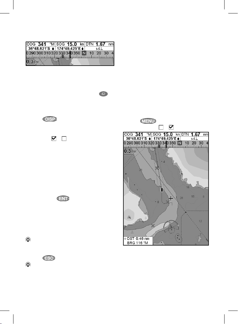
2-7-3 Data header
The displays can show data at the top, called the
data header.
When you select a window from the display
menu (see section 2-7) the 657 displays an
appropriate data header for the window.
Each favorite display (see section 2-7-2) has
its own data header. When you press
to recall a favorite display, the 657 recalls the
favorite displays data header.
Setting the data header for a display
1 Press
2 To turn the data header on or of f:
i Select Data.
ii Select
3 To select the size of the data:
i Select Size.
ii Select the size to display.
4 To change the data displayed:
i Select Data setup.
ii Change a data field:
a Press the cursor keys to highlight the
b Press
c Select a data item that is available
iii Repeat the above step to set the other
data fields.
Tip: If all fields in a line are None then the line
will not be displayed and the data header will
take less space on the display.
5 Press .
Tip: The data header will change when you
select another display. To set a data header that
you can recall later, set the header as part of a
favorites display (see below).
and selec t Data header.
or .
field.
to display a menu of
data items.
on your system or select None to
leave the field empty.
Favorites displays and data headers
To set a data header for a favorites display, follow
the steps to add a favorite (see section 2-7-2
- Adding a favorite display to the list). In step 1,
set the data header for the favorite as described
above.
2-7-4 Compass
The chart, sonar and highway displays can show a
compass at the top of the window.
The compass always shows the boat’s course
over ground (COG), a black symbol in the middle.
When the boat is navigating to a point, the
compass also shows bearing to the destination
(BRG), a red symbol.
In this example, BRG is 332°M and COG is 341°M.
To turn the compass off or on:
1 Press
2 Set Compass to or .
and selec t Data header.
Northstar Explorer 657 Installation and Operation Manual18
Page 19
3 Navigation: Chart
The chart window shows the chart, the boat’s
position course and navigation data.
3-1 Introduction to navigating
The 657 has two ways of navigating, going straight
to a point or following a route.
3-1-1 Navigating to a point
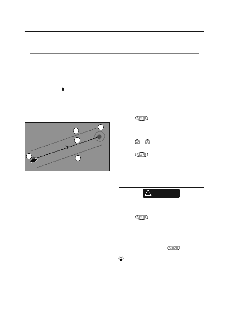
When the 657 is navigating to a point, the chart
and highway displays show navigation data:
A The boat position
B The destination point marked with a circle.
C The boat’s plotted course to the destination.
D Two CDI lines, parallel to the boat’s plotted
course, which indicate the maximum
expected deviation from the plotted course.
A
For more information, see appendix C.
If the 657 is connected to an autopilot, the 657 will
send data to the autopilot to steer the boat to the
destination. Start the autopilot before starting to
navigate to the point.
If the 657 has no autopilot, steer the boat
manually:
a use the boat position and destination on the
chart or highway displays
b or use navigation data displayed on the data
header (see section 2-7-3)
c or use COG and BRG on the compass (see
section 2-7-4).
Note:
1 If the XTE alarm is enabled, an alarm will
sound if the boat deviates too much from its
intended course (see section 17-9).
2 If the arrival radius alarm is enabled, then an
alarm will sound to show that the boat has
reached the destination (see section 17-9).
.
D
C
D
B
3-1-2 Going to a waypoint or to a point on
the chart
A waypoint is a position that you can set on the
657 chart, for example a fishing spot or a point on
a route (see section 5).
Going to a waypoint from the chart window
1 Go to the chart window.
2 Move the cursor to the waypoint:
either use the cursor keys or use Find (see
section 3-2-5).
3 Press
Going to a waypoint from the waypoints
window
1 Go to the waypoints window.
2 Press
goto.
3 Press
Going to a point on the chart
1 Switch to a chart window.
2 Move the cursor to the destination point:
either use the cursor keys or use Find (see
section 3-2-5).
Make sure the course does not pass over land
or dangerous waters.
3 Press
Navigating
The 657 navigates to the point as described in
section 3-1-1.
Cancelling navigating
Go to a Chart window, press
Cancel goto.
Tip: Before starting, create waypoints at points
of interest. Create a waypoint at the start of the
trip for you to navigate back to (see section 5-2-1).
and select Goto.
or to highlight the waypoint to
and select Goto.
!
WARNING
and select Goto cursor.
and select
19Northstar Explorer 657 Installation and Operation Manual
Page 20
3-1-3 Following a route
Preparing
A route is a list of waypoints that the boat can
follow (see section 6).
To create waypoints before creating the
route, see section 5-2-1.
To create a route, see section 6-2-1.
Starting a route from the chart window:
1 Go to the chart window.
2 Press
3 Press
follow. Press .
4 The 657 asks for the direction to traverse the
route.
Select Forwa rd (the order the route was
created) or Reverse.
5 The 657 displays the chart with the route
marked and starts navigating from the start
of the route.
Starting a route from the routes window:
1 Go to the routes window.
2 Then follow step 3 as in starting a route
from the chart window above.
Navigating
The 657 navigates to each waypoint on the route
in turn as described in section 3-1-1.
The 657 stops navigating to the waypoint at the
end of the current leg and starts the next leg of
the route:
a when the boat comes within 0.025 nm of the
waypoint
b or when the boat passes the waypoint
c or if you skip the waypoint.
and selec t Start Route
or to highlight the route to
Skipping a waypoint
To skip a waypoint, go to a chart window,
press
navigating straight towards the next waypoint
on the route.
Skipping a waypoint with the autopilot on
might result in a sudden course change.
Cancelling a route
When the boat has reached the final waypoint, or
to stop the boat following the route at any time,
cancel the route. Go to a chart window, press
and selec t Skip. The 657 starts
!
WARNING
and selec t Cancel route.
Northstar Explorer 657 Installation and Operation Manual20
Page 21
3-2 Chart window
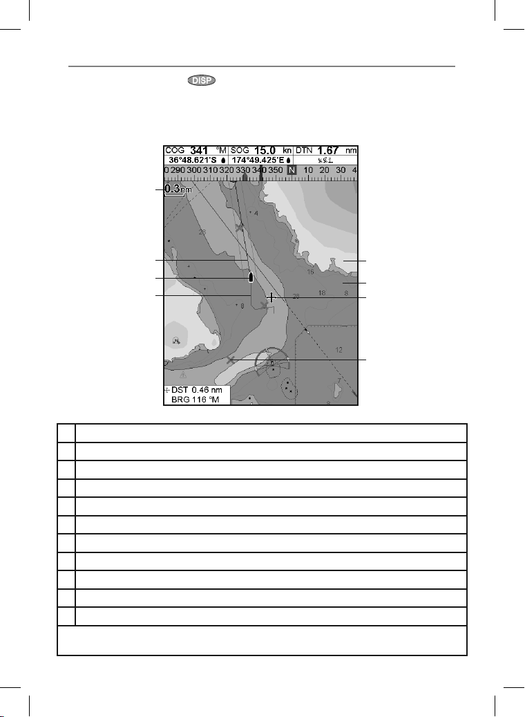
To go to the Chart window, press
Chart.
select
A typical chart window shows:
A
B
C
then
F
D
E
G
A Data header. To turn the data off or on or to change what data is displayed, see section 2-7-3
B Compass (see sec tion 2-7-4)
C Char t scale (see section 3-2-3)
D Boat position (see section 3-2-1)
E Boat track (see section 3-5)
F Boat course and CDI lines (see Appendix C, CDI).
G Distance and bearing of cursor from boat
HLand
ISea
J The cursor (see section 3-2-1)
K A typical waypoint (see section 5)
Note: To change the types of information displayed on the chart, see section 17-2. To change to a
perspective view of the chart, see sec tion 3-2-6.
H
I
J
K
21Northstar Explorer 657 Installation and Operation Manual
Page 22
3-2-1 Chart modes
The Chart has two modes:
Center on boat mode
To switch to center on boat mode in the char t
window, press
of the chart. As the boat moves through the
water, the chart automatically scrolls to keep the
boat in the center of the chart. The cursor (see
below) is turned off.
Cursor mode
The keys and are called cursor keys.
To switch to cursor mode in the chart window,
hold down a cursor key. The cursor
and moves away from the boat:
Press the key which points in the direction
that the cursor will move, for example press
to move the cursor down.
Press midway bet ween two of the cursor keys
to make the cursor move diagonally.
Hold a cursor key down to make the cursor
move continuously across the display.
In Cursor mode:
The distance (
the cursor from the boat are displayed at the
bottom corner of the display.
The chart does not scroll as the boat moves.
If the cursor reaches the edge of the display,
the chart will scroll.
For example, hold down
cursor to the right side of the display and the
chart will scroll to the lef t.
. The boat is at the center
DST) and bearing ( BRG) of
to move the
3-2-2 Latitude and longit ude
Latitude and longitude can be displayed in
the data header. The display is degrees and
minutes to three decimal places, about 2 m (6
ft) resolution. Normally the position is the boat’s
position, and the latitude and longitude has a
boat symbol to show this:
36° 29.637’ N or S Latitude
175° 09.165’ E or W Longitude
If the cursor has been moved in the last ten
seconds, then the position is the cursor ’s position,
and the latitude and longitude has a cursor
symbol to show this:
36° 29.841’ N or S Latitude
175° 09.012’ E or W Longitude
Northstar Explorer 657 Installation and Operation Manual22
appears
!
WARNING
When reading the boat position, make sure
the position is not the cursor position.
3-2-3 Chart scale
Press to zoom in and display a smaller area of
the chart in more detail. Press to zoom out
and display a bigger area in less detail.
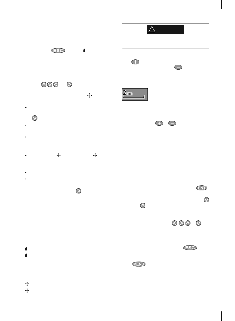
The chart scale is displayed at the top lef t of the
chart:
3-2-4 Chart symbols and info rmation
The chart shows many kinds of symbols, such as
waypoints, ports, marinas, buoys and beacons. If
necessary, press or
scale where the symbol is displayed.
To see stored information about a symbol:
1 Either move the cursor to the symbol on the
chart and wait two seconds
or use Find to move the cursor to a symbol
for a port or service (see section 3-2-5).
2 A window appears at the bottom of the
display with some information about the
symbol.
3 To see more detail about a symbol or a list of
associated items for the symbol, press
i Select an item to display. If there are more
items than will fit on the display, press
or to scroll up or down.
Select a camera icon to display a photo
of the item. If the photo is too big to fit
on the display, press
scroll the photo.
Select Tide St ation to display a tide
chart for the position (see section 13).
ii Select other items or press
return to the char t.
To see stored information about nearby symbols
press
follow step 3 above.
or to choose a chart
, , or to
to
and selec t Chart info. Then
:
Page 23
3-2-5 Finding a char t symbol
To find and display a char t symbol:
1 Press
2 Select the type of symbol: Waypoints, Routes,
Ports by name, Ports & services, Tide stations
or AIS Vessels.
3 For Ports & services: select the type of service
to find.
For Ports by name: press
enter a name or let ters contained in the port
name, then press .
4 A list of items is displayed. If there are more
items than will fit on the display, press
and selec t Find.
, , or to
or
to page up and down.
3-3 Distance and bear ing calculator
The distance and bearing calculator can plot
a course of one or several legs and show the
bearing and length of each leg, as well as the
total distance along the course. The completed
course can be converted into a route.
To use the distance and bearing calculator:
1 Select the Chart window. Press
select Distanc e.
2 Move the cursor to the start of the first leg. It
does not matter if this point is a waypoint or
not. Press
3 To add a leg to the course, move the cursor
to the end of the leg. It does not matter if this
point is a waypoint or not. The display shows
the bearing and length of the leg, as well
as the total distance along the course. Press
.
.
and
For Ports by name: to search for a different
port name, press
then press .
5 Select the item and press
window changes to show the item in the
middle of the display.
To see stored information about the item,
press
(see section 3-2-4).
. change the name,
. The chart
3-2-6 Perspective view
Perspective view shows the chart from an
angle instead of from straight above. To turn
perspective view on or off, press and set
Perspective to
4 To remove the last leg from the course, press
5 Repeat the above two steps to enter the
whole course.
6 To save the new course as a route, press
new points on the course as new waypoints,
with default names. If necessar y, edit the
route later (see section 6-2-2) and edit any
new waypoints later (see section 5-2-3).
7 Finally, press
window.
or .
and selec t Remove.
and selec t Save. This also saves any
to return to the char t
3-4 Projecte d course
If Projected course is turned on, then the 657
will display the projected position based on the
course over ground (COG), speed and a specified
time. To turn Projected course on and off and to
set the time, see section 17-2.
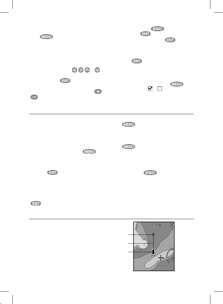
A Projected position
B Boat’s projected course
C Boat position
A
B
C
23Northstar Explorer 657 Installation and Operation Manual
Page 24
3-5 Tracks and trackin g
Tracking records the boat’s position to memory at
regular intervals, which can be:
Time intervals.
Or distance intervals.
The track of where the boat has been can be
displayed on the chart. The 657 can display one
track while recording another.
To work with track s, see section 17-6.
The 657 can store five tracks:
Track 1 can hold up to 200 0 points and is
intended to record the normal progress of
the boat.
Tracks 2, 3, 4 and 5 can hold up to 500 points
each and are intended to record sec tions to
be retraced accurately, for example entering a
river mouth.
Tip: Record a reference tracks and then use
the track to help navigate the same trip later.
For example, record a reference track as you
leave harbour. Then if you return to harbour and
visibility is poor, selec t the chart and navigate
manually along the reference track back into
4 Navigation: Highway window
A
B
C
D
E
F
G
the harbour. Record reference tracks in good
conditions.
When recording is on and the track becomes full
then recording continues and the oldest points
in the track are deleted. The maximum length of
a track depends on the selected track interval: a
small interval will give a shor ter, more detailed
track and a long interval will give a longer, less
detailed track, as shown in these examples:
Time intervals
Interval Track 1 Track 2, 3, 4 or 5
1 sec 33 minutes 8 minutes
10 sec 5.5 hours 1.4 hours
1 min 33 hours 8 hours
Distance intervals
Interval Track 1 Track 2, 3, 4 or 5
0.01 20 5
1 2,000 500
10 20,000 5,000
The track lengths are in the current distance units,
for example nm.
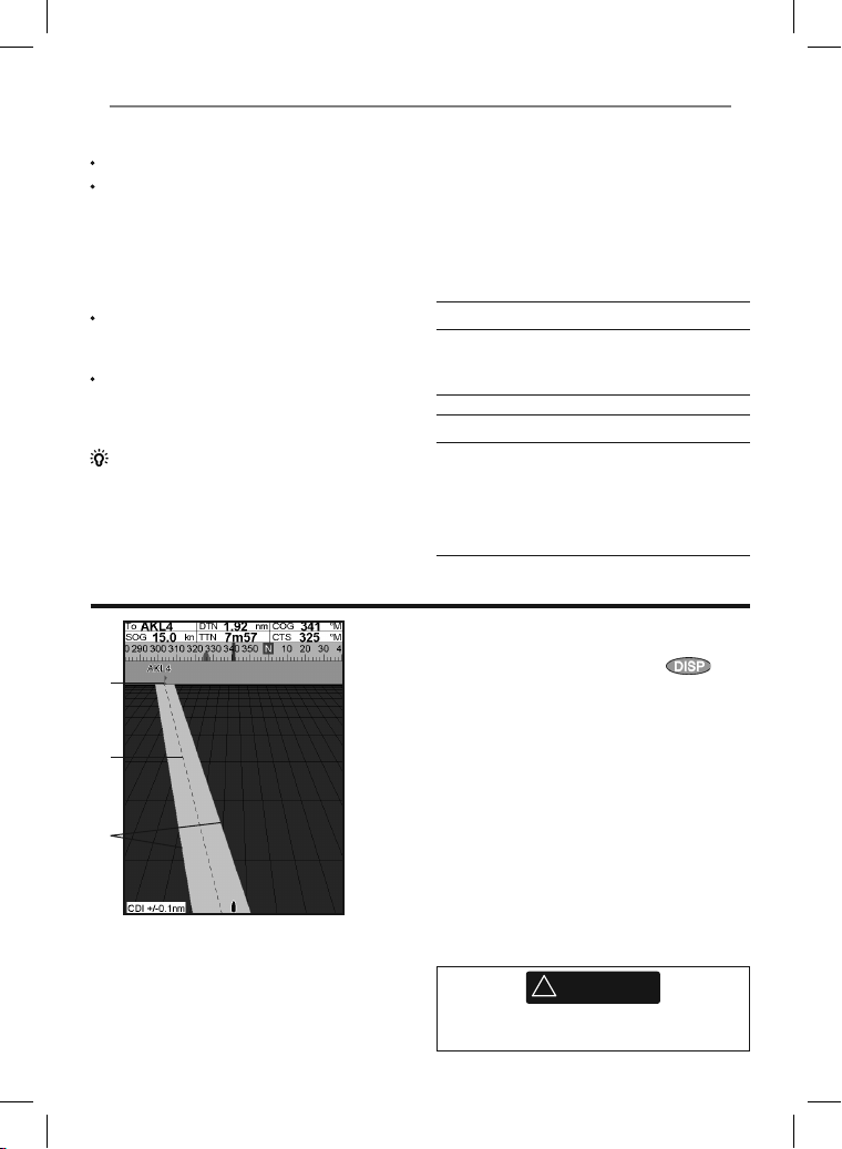
The highway window has a bird’s eye view of the
boat’s course to a destination:
To go to the highway window, press
select More, then select Highway.
The highway window shows:
A Optional data header (see section 2-7-3)
B Optional compass (see section 2-7-4)
C Destination waypoint
D Boat’s plot ted course to destination
E CDI lines, parallel to the boat’s plotted course
(see Appendix C, CDI). The CDI lines are like a
highway over the water where the boat will
move.
F CDI scale
G The boat position is at the bottom, center of
the display.
,
!
WARNING
The highway window does not show land,
dangerous waters or chart symbols.
Northstar Explorer 657 Installation and Operation Manual24
Page 25
5 Navigation: Waypoints
A waypoint is a position that you can set on the
657 chart, for example a fishing spot or a point on
a route. The 657 can have up to 3000 waypoints.
A waypoint can be created, changed or deleted.
A waypoint has:
A name (up to eight characters).
An icon showing what kind of waypoint it is.
The available icons are:
A position.
A color for the waypoint symbol and name
on the chart.
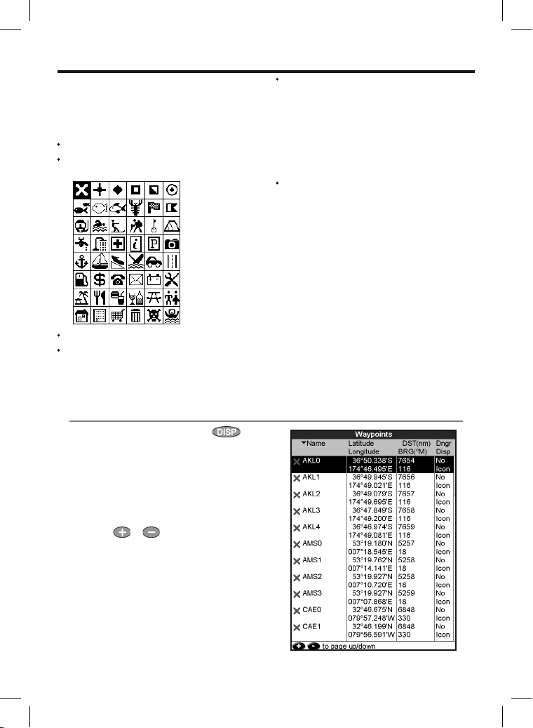
5-1 Waypoints windo w
To go to the waypoints window, press ,
select More, then select Waypoints.
The waypoints window is a list of the waypoints
that have been entered, each with waypoint
symbol, name, latitude and longitude, distance
and bearing from the boat, type and display
option.
If there are more waypoints than will fit on the
display, press
page at a time.
or to scroll up or down a
A type:
Normal: A normal waypoint can be
navigated to or included in a route.
Danger: A danger waypoint is a point
to avoid. If the boat comes within the
danger radius of a danger waypoint the
unit can sound an alarm. (see section
17- 9).
A display option:
Controls how the waypoint is displayed
when the
Waypoints setup option is set to
Selected (see sec tion 17-2):
Off: The waypoint is not displayed.
Icon: The waypoint icon is displayed.
I+N (Icon and Name): The waypoint
icon and name are displayed.
If there are many waypoints, use this feature
to select which waypoints are displayed on
the chart.
Note: The other choices for Waypoints are Hide
all and Show all (see section 16-2).
25Northstar Explorer 657 Installation and Operation Manual
Page 26
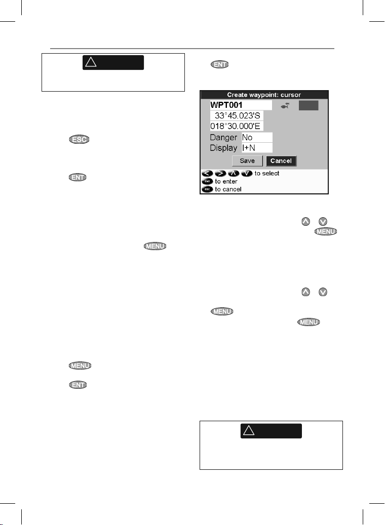
5-2 Managing wayp oints
!
WARNING
Do not create a navigation waypoint on land
or in dangerous water.
5-2-1 Creating a new waypoint
Creating and editing a new waypoint from
the chart window
1 To create a waypoint at the boat position,
press
boat mode.
Or, to create a waypoint at a different point,
move the cursor to that point on the chart.
2 Press
3 A new waypoint, with the default name and
data is created.
4 Change the waypoint data if necessary (see
section 5-2-7).
Creating a new waypoint from the waypoints
window
1 In the waypoints window, press
select Create.
2 A new waypoint, with a default name and
data, is created at the boat position.
3 Change the waypoint data if necessary (see
section 5-2-7).
Note: Waypoints can also be created when a
route is created (see section 6-2-1).
to switch the chart to center on
.
and
5-2-2 Moving a waypoint
Moving a waypoint from the chart window
1 In the chart window, move the cursor to the
waypoint to move.
2 Press
3 Move the cursor to the new position and
press
Moving a waypoint from the waypoints
window
To move a waypoint from the waypoints window,
edit the waypoint (see section 5-2-3) and change
the latitude and longitude.
and select Move.
.
5-2-3 Editing a waypoint
Editing a waypoint from the chart window
1 In the chart window, move the cursor to the
waypoint to edit.
Northstar Explorer 657 Installation and Operation Manual26
2 When the waypoint data is displayed, press
.
3 Change the waypoint data
(see section 5-2-7).
Editing a waypoint from the waypoints
window
1 In the waypoints window, press
highlight the waypoint to edit. Press
and select Edit.
2 Change the waypoint data (see section 5-2-7).
or to
5-2-4 Displaying a waypoint on the chart
This goes to the chart window, and shows the
selected waypoint at the center of the window.
1 In the waypoints window, press
to highlight the waypoint to display. Press
and select Display.
Or, in the Chart window, press
Find, then select Waypoints. Select a
waypoint from the list.
2 The 657 switches to the chart window, with
the selected waypoint at the center of the
chart.
or
, select
5-2-5 Deleting a waypoint
A waypoint can not be deleted if the boat is
navigating to it or if the waypoint is used in more
than one route. A waypoint that is used in one
route can be deleted.
!
WARNING
When a waypoint is deleted from a route,
check that the changed route does not cross
land or dangerous waters.
Page 27
Deleting a waypoint from the chart window
1 In the chart window, move the cursor to the
waypoint to delete.
2 Press
3 Select Yes to confirm.
Deleting a waypoint from the waypoints
window
1 In the waypoints window, press
to highlight the waypoint to delete. Press
2 Select Yes to confirm.
and select Delete.
or
and select Delete.
5-2-6 Deleting all waypoints
1 In the waypoints window and press
and select Delete all.
2 Select Yes to confirm.
5-2-7 Changing a waypoint’s data
To change the waypoint data when it is displayed
in a window:
1 Select the data to change.
Press
Use the cursor keys to change the data.
Press
.
.
6 Navigation: Routes
A route is a list of waypoints that the boat can
navigate along. Routes can be created, changed
and deleted.
The 657 can have up to 25 routes. Each route can
have up to 50 waypoints.
A route can:
Start and stop at the same waypoint .
Include waypoints more than once.
The 657 can navigate along a route in either
direction. Waypoints on the route can be skipped.
2 If necessary, repeat the above step to change
other data.
3 Select Save.
5-2-8 Sort Waypoints
To change how the waypoints list is displayed:
1 Press
2 Select how to display the list:
Name: In alphabetical order by name.
Icon: Grouped by icon type.
Distance: In order of distance from the
boat.
An arrow at at the top of a column indicates how
the waypoints are sorted.
and select Sort by.
5-2-9 Navigating to a waypoint
See section 3-1-2.
Routes are a powerful feature when the 657 is
connected to an autopilot, allowing the vessel to
be automatically guided along the route.
!
WARNING
Make sure the course does not pass over land
or dangerous waters.
27Northstar Explorer 657 Installation and Operation Manual
Page 28
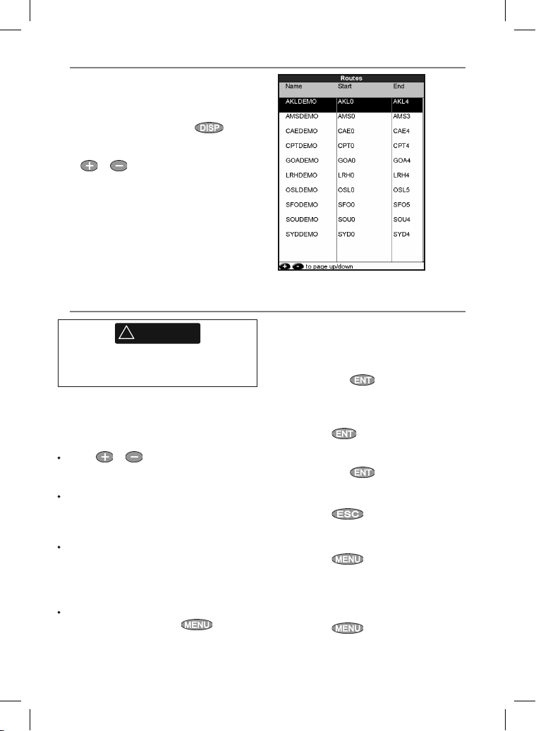
6-1 Routes window
The routes window is a list of the routes that
have been entered, each with route name, start
waypoint, end waypoint, number of legs and
total distance.
To go to the routes window, press
More, then select Routes.
If there are more routes than will fit on the display,
press
or to scroll up or down a page at
a time.
, select
6-2 Managing routes
!
WARNING
After creating or changing a route, display the
route on the char t and check that it does not
cross land or dangerous water.
6-2-1 Creating a new rou te
A. Creating a new route from the chart
window
While creating the route:
Press
or to change the range; scroll
the chart by moving the cursor to the edge of
the chart.
A data box at the bottom lef t of the display
shows the route name and total distance. If
the cursor is near a leg, it shows the length
and bearing of the leg as well.
The legs of a route must star t and end at
waypoints. If a leg does not star t or end at an
existing waypoint then a new waypoint will
be created automatically (to change the new
waypoint data, see sec tion 5-2-7).
You can not use a Danger waypoint in a route.
1 In the chart window, press
New route.
2 The route is given a default name:
and selec t
Northstar Explorer 657 Installation and Operation Manual28
i Change the name if necessary.
ii Select OK.
3 To enter the legs of the route:
i Move the cursor to the start of the route
and press
ii A waypoint is created with a default
name. to save this waypoint press enter,
to edit the waypoint refer to 5-2-7
iii Press
from the cursor to the previous waypoint
iv Move the cursor to the end of the first leg
and press
v Repeat i to iv until the last waypoint in
the route is placed and saved
vi Press
Menu options while creating a route:
1 To add a waypoint to the route
i Press
2 To insert a waypoint in the route by breaking
one leg into two:
i Move the cursor to the leg you want to
break.
ii Press
iii Move the cursor to where the new route
waypoint will be.
.
a dotted leg line is displayed
.
to complete the route
and selec t Add.
and selec t Insert.
Page 29
iv Press .
3 To move a waypoint in the route:
i Move the cursor to the waypoint to
move.
ii Press
iii Move the cursor to where the waypoint
will be.
iv Press
4 To remove a waypoint from the route:
i Move the cursor to the waypoint to
remove from the route.
ii Press
waypoint is removed from the route, but
the waypoint is not deleted.
5 To start navigating the route
i Press
6 To end creating the route
i Press
7 To delete the route
i Press
ii Selec t yes to confirm.
Tip: The distance and bearing calculator can
also be used to enter a course and save it as a
route (see section 3-3).
B. Creating a new route from the routes
window
1 In the routes window, press
select Create.
2 A new route, with a default name and no
waypoints, is displayed.
3 To change the route name:
i Select the route name at the top of the
display and press
ii Change the name if necessary.
iii Press
4 To insert a waypoint in the route:
i Select where the waypoint will be:
route, select Leg 1.
the route, select the unused leg at
the end of the list of waypoints.
insert the new waypoint in front of.
and selec t Move.
.
and selec t Remove. The
and selec t Star t
and selec t End
and selec t Delete
and
.
.
To insert the first waypoint in a new
To insert a waypoint at the end of
Otherwise, selec t the waypoint to
ii Press
displayed. Select the waypoint to use.
As waypoints are inser ted, the distance and
bearing of each leg is shown automatically. If
the route has more waypoints than will fit on
the display, press
5 To remove a waypoint from the route:
i Select the waypoint to remove.
ii Press
6 Repeat this process until the route is finished.
7 Press
8 Display the route on the chart (see section
6-2-3) and check that the route does not cross
land or dangerous water.
. A list of waypoints is
or to see them.
and selec t Remove.
.
6-2-2 Editing a route
Editing a route from the chart
1 In the routes window, select the route to edit.
Press
2 The selected route is displayed on the chart,
with a circle around the first waypoint.
3 Edit the route as described in section 6-2-1 A,
starting at step 4.
Editing a route from the routes window
1 In the routes window, press
highlight the route to edit. Press and
select Edit.
2 The selected route is displayed: the route
name and a list of the waypoints.
3 Edit the route as described in section 6-2-1 B,
starting at step 3.
and selec t Edit on cha rt.
or to
6-2-3 Displaying a route on the char t
To view the selec ted route at the center of the
display:
1 In the routes window, press
highlight the route to display. Press
and select Display.
Or, in the Chart window, press
Find, then select Route. Select a route
from the list.
2 The 657 displays the selected route on the
chart.
or to
, select
29Northstar Explorer 657 Installation and Operation Manual
Page 30
6-2-4 Deleting a route
1 In the routes window, press or to
highlight the route to delete. Press
and selec t Delete.
2 Select Yes to confirm.
7 Satellites
GPS worldwide navig ation
The US Government operates the GPS system.
Twenty-four satellites orbit the earth and
broadcast position and time signals. The positions
of these satellites are constantly changing. The
GPS receiver analyses the signals from the closest
satellites and calculates exactly where it is on
earth. This is called the GPS position.
The accurac y of the GPS position is typically
better than 10 m (33 ft) for 95% of the time. A
GPS antenna can receive signals from the GPS
satellites when it is almost any where on earth.
DGPS
A DGPS system uses correction signals to remove
some of the errors in the GPS position. The 657
can use one of two types of DGPS system:
WAAS and EGNOS DGPS
WAAS and EGNOS are two satellite based
DGPS systems. The correction signals are
broadcast by satellites and are received by
the 657’s standard GPS antenna. The accuracy
of the correc ted GPS position is typically
better than 5 m (15 ft) for 95% of the time.
WAAS covers all of the USA and most of
Canada. EGNOS will cover most of Western
Europe when it becomes operational.
6-2-5 Deleting all routes
1 In the routes window, press and
select Delete all.
2 Select Yes to confirm.
6-2-6 Navigating a route
See section 3-1-3.
Differential beacon DGPS
Differential beacons are land based radio
transmitters that broadcast correc tion signals
that can be received by a special receiver
on the boat. Differential beacons are usually
only installed near por ts and important
waterways, and each beacon has a limited
range. The accuracy of the corrected GPS
position is t ypically better than 2 to 5 m (6 to
16 f t).
GPS receiver
Northstar GPS units have a sensitive 12-channel
receiver, which tracks signals from all GPS
satellites visible above the horizon and uses
measurements from all satellites more than 5°
above the horizon to calculate the position.
Each time a GPS receiver is turned on, it normally
takes about 50 seconds before it output s the first
position. Under some circumstances it will take
up to two minutes or longer.
Northstar Explorer 657 Installation and Operation Manual30
Page 31
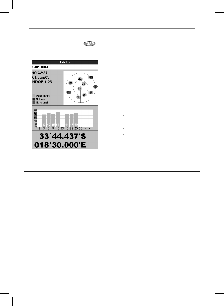
7-1 Satellite window
The satellite window has information about the
GPS satellites and GPS position.
To go to the satellite window, press
select More, then select Satellite.
The satellite window shows:
A
B
C
D
E
,
F
G
8 Sonar fishfinding: Introduction
Sonar functions require an optional sonar
transducer to be installed and set up.
This section explains how to interpret the sonar
displays, when and why to use the dif ferent
frequencies and how fish are detected and
displayed.
A Status of GPS antenna, for example
Acquiri ng, GPS fix, No GPS. If the unit
is in Simulate mode it displays Simu late
(see section 2-6).
B Time and date from GPS satellites. Time is
local time (UTC [GMT] plus local of fset, see
section 17-13)
C HDOP: The error in the GPS position caused
by satellite geometry. A low value indicates a
more precise fix, a high value a less precise fix
D Signal strengths of up to twelve visible GPS
satellites. T he higher the bar the stronger the
signal
E Boat position
F Positions of visible GPS satellites:
Outer circle is horizon
Inner circle is 45° elevation
Center is directly above
North is at top of display
G If the boat is moving, COG is a line from
center
It also describes Gain and Range and shows
examples of some of the different sonar displays.
8-1 Using the 657
The 657 uses a sonar transducer attached to
the hull. The transducer generates an ultrasonic
pulse (sound that is above the hearing range
of the human ear), which travels down towards
the bottom at a speed of about 4800 ft/sec
(1463 m/sec), spreading out into a cone shape.
When the pulse meets an object, such as a fish or
the bottom, it is partly reflected back up towards
the boat as an echo. The depth of the objec t or
bottom is calculated by the 657 by measuring
the time taken between sending a pulse and
receiving the echo. When an echo has been
returned, the next pulse is sent.
The 657 converts each echo into an electronic
signal, displayed as a vertical line of pixels. The
most recent echo appears on the extreme right
of the display, with the older echoes being
scrolled towards the left, eventually disappearing
off the display.
31Northstar Explorer 657 Installation and Operation Manual
Page 32
The scroll sp eed depends upon the water depth
and scroll speed setting. See sections 17-3 and
section 8-2, for more information.
The appearance of echoes displayed are affec ted
by:
• the 657 settings (see sections 17-3, 8-5 and
8-6)
• echoes (dif ferent fish types, different bot tom
types, wrecks and seaweed; see section 8-2)
• noise (water clarity and bubbles; see section
8-2).
Cruising, Fishi ng and Manual Mode s
The 657 has three sonar operating modes:
• Cruising mode: Use this when on the move.
The 657 automatically adjusts its settings to
compensate for water clarit y and to display
the bottom.
8-2 Interpreting the d isplay
The sonar displays do not show a fixed distance
travelled by the boat; rather, they display a
history, showing what has passed below the boat
during a certain period of time.
The histor y of the sonar signal displayed depends
the depth of the water and the scroll speed
setting.
In shallow water, the echoes have a short distance
to travel between the bot tom and the boat. In
deep water, the history moves across the display
more slowly because the echoes take longer to
travel between the bot tom and the boat. For
example, when the scroll speed is set to Fast,
at depths over 1000 f t (300 m) it takes about 2
minutes for the data to move across the display,
whereas at 20 ft (6 m) it takes only about 25
seconds.
The scroll speed can be set by the user to display
either a longer history with less fish information
or a shorter history with more fish details (see
section 17-3).
If the boat is anchored, the echoes all come from
the same area of bottom. This produces a flat
bottom trace on the display.
The screen shot shows a typical sonar display
with the Fish symbols turned Off.
• Fishing mo de: Use this when fishing. The
657 automatically adjusts its settings to
compensate for water clarity and to best
display fish, the bottom and other details.
• Manual mode: Use this to fine-tune the
657 settings by hand. Best results are often
achieved in manual mode, but practice
and experience are required to obtain the
optimum settings for dif ferent conditions.
For more information about modes, see sections
8-5 and 8- 6.
!
WARNING
Use the automatic Cruising or Fishing modes
when learning to use the 657 or when
travelling at speed.
Strength of echoes
The colours indicate differences in the strength of
the echo. The strength varies with several factors,
such as the:
• Size of the fish, school of fish or other objec t.
• Depth of the fish or object.
• Location of the fish or object. ( The area
covered by the ultrasonic pulse is a rough
cone shape and the echoes are strongest in
the middle.)
• Clarit y of water. Particles or air in the water
reduce the strength of the echo.
• Composition or densit y of the object or
bottom.
Note: Planing hulls at speed produce air
bubbles and turbulent water that bombard the
transducer. The resulting ultrasonic noise may
be picked up by the transducer and obscure the
real echoes.
Northstar Explorer 657 Installation and Operation Manual32
Page 33
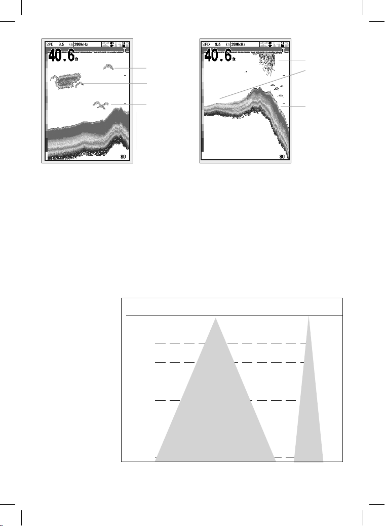
A
B
C
D
A
B
C
A Single fish
B Large school of fish
C Small school of fish
D Bottom
Bottom typ es
Mud, weed and sandy bottoms tend to weaken
and scatter the sonar pulse, resulting in a weak
echo. Hard, rocky or coral bottoms ref lect the
pulse, resulting in a strong echo.
Frequency a nd cone width
The sonar pulse
generated by the 657
transducer travels down
through the water,
spreading outwards in
a cone shape. The cone
width is dependent
upon the frequency of
the pulse; at 50 kHz it
is approximately 45°,
and at 200 kHz it is
approximately 11°.
The differences in the
cone width af fect what is
displayed. See
section 8-3.
Water Cone width Cone width
Depth at 50 kHz at 200 kHz
25 20 5
50 40 10
100 80 20
150 130 30
200 170 40
300 250 60
400 330 80
600 500 120
800 660 150
1000 830 190
A Kelp / Weed
B Soft bot toms such as mud, weed and sand
show as narrow bands
C Hard bottoms such as rock or coral show as
wide bands
45° cone
11°
cone
33Northstar Explorer 657 Installation and Operation Manual
Page 34
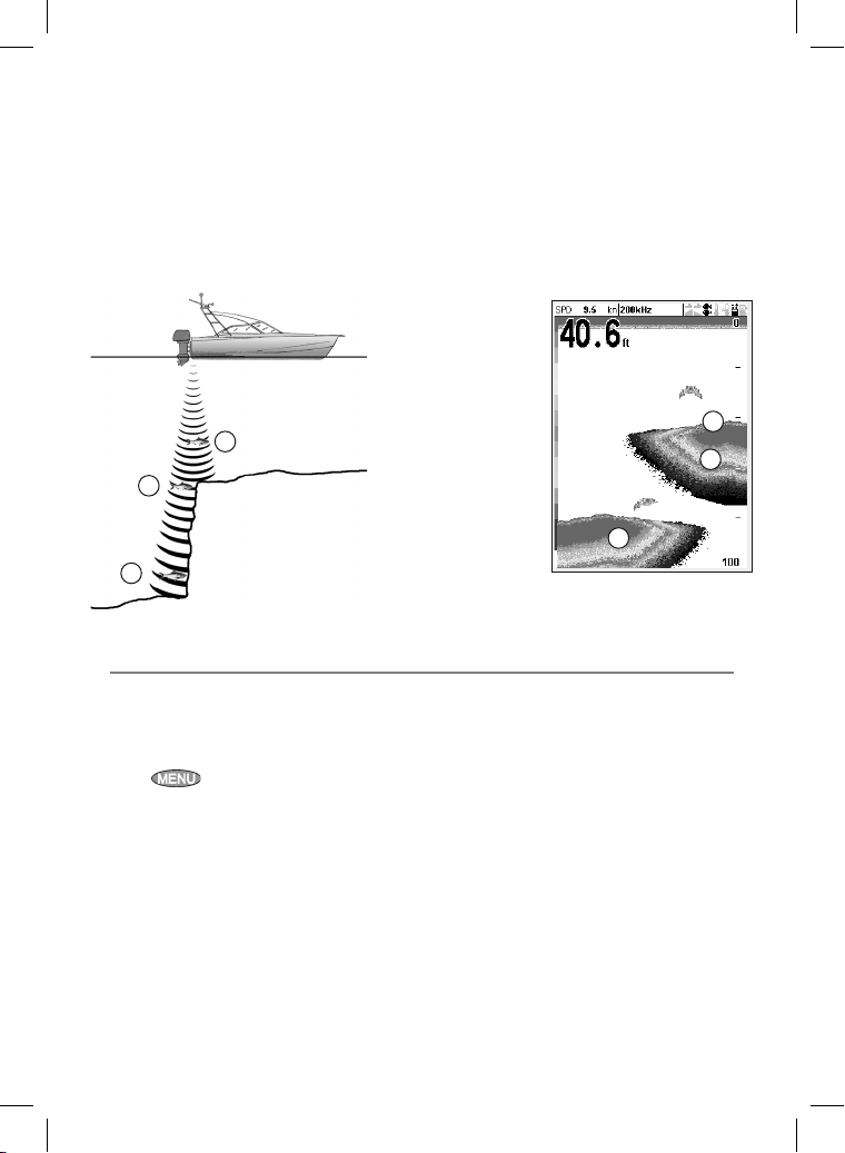
Shadows
Shadows are created around areas where the ultrasonic beam cannot ‘see’. These areas include hollows
on the bottom or beside rocks and ledges, where the strong echoes returned off the rocks obscure the
weak echoes of the fish and may also create a double bottom trace. See following for an example of the
sonar display in such an environment. A double bottom trace is shown on the display.
When looking for fish with the wide angled 50 kHz frequency, be aware of increased shadows. Use the
high frequency 200 kHz in areas that have rocks and ledges because this frequency reduces the shadow
effect considerably.
Exampl e of shadows
A
B
A
A Fish is visible on the display
B Fish is hidden by the strong
echoes of f the bottom and is not
shown on the display
8-3 Single and D ual frequency fi shfinding
Sonar frequ encies
The 657 has two sonar frequencies, 200 kHz and
50 kHz. To select the sonar frequency to use:
1 Go to a sonar display (see section 9).
2 Press
200 k Hz , 50 k Hz,or Mixed.
, select Frequency and selec t
When to use 200 kHz
The 200 kHz frequenc y is especially suitable for
use in shallow and medium depth water, typically
less than 500 f t (150 m) and while running at
speed.
At 200 kHz, the narrow cone reduces any noise
caused by air bubbles.
The 200 kHz frequency generates a higher
definition pulse which produces little shadow
and returns excellent detail over a small area
of bottom. Therefore, it gives excellent bottom
Sonar displ ay of same area
A
B
A
discrimination capability and is par ticularly good
at showing individual fish, including bottom
dwellers.
When to use 50 kHz
The 50 kHz frequency is particularly suitable for
use in deep water, typically greater than 500 ft
(150 m).
At 50 kHz, the cone covers an area of water about
four times wider than the 200 kHz cone and
penetrates to a greater depth with minimal loss of
the return signal.
However, it produces a lower definition display
with more shadow compared to the 20 0 kHz
frequenc y. This means that a group of small fish,
for example, could be displayed as a single item,
while any fish ver y close to the bottom may not
be found at all.
Northstar Explorer 657 Installation and Operation Manual34
Page 35
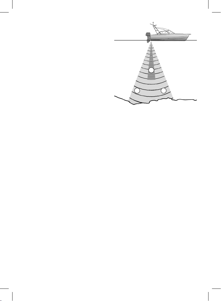
This frequency is useful for getting a deep, wide
overview of the area so that any areas of interest
can be identified and then examined in detail
with the 200 kHz frequency.
When to use Mix ed
The Mixed frequenc y combines the 200 kHz and
the 50 kHz echoes on one sonar display, filling
in detailed echoes in the center of the sonar cone.
When to use 50/200 kHz
Operating the 657 at both 50 kHz and 200 kHz
simultaneously on a split display can be very
useful when operating in shallow to medium
water, typically less than 500 ft (150 m), because
the 50 kHz sec tion of the display shows the
general area, while the 200 kHz section can be
viewed simultaneously for a more detailed look at
any interesting feature.
To use 50/200 kHz, select the Split 50/200 display
(see section 9- 4).
A
B B
A Narrow angle, more detailed 200 kHz cone
B Wide angle, less detailed 50 kHz cone
35Northstar Explorer 657 Installation and Operation Manual
Page 36
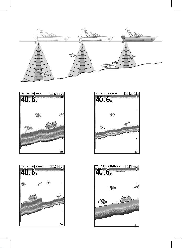
Comparison of th e same fish scenario displ ayed at different f requencies:
1 minute ago 30 seconds ago Now
50 kHz display 200 kHz display
200/50 Khz display M ixed display
Northstar Explorer 657 Installation and Operation Manual36
Page 37
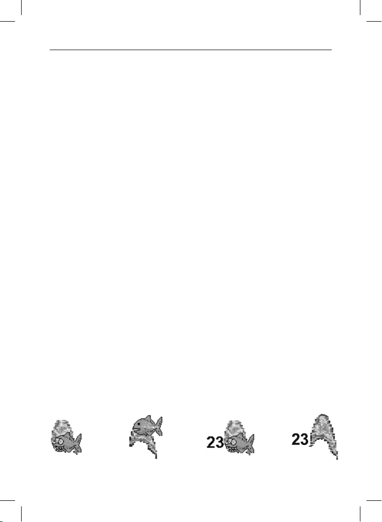
8-4 Fish detec tion and display
Where to find f ish
Underwater features like reefs, wrecks and rocky
outcrops attract fish. Use the 50 kHz or 50/200
kHz frequency display to find these features, then
look for fish by passing over the feature slowly
several times using the Zoom display (see section
9-2). If there is a current, the fish will often be
found downstream of the feature.
When fishing with the 657 with the Fish symbols
Off, a weak fuzzy band may appear between
the bottom trace and surface. This might
indicate a thermocline - a rapid change in water
temperature, such as the edge of a warm or
cold current. The temperature difference can
form a barrier which the fish may not swim
through. In fresh water, fish often collect around
a thermocline.
Fish sy mbols
The 657 uses Northstar’s SBN II technology to
analyse sonar echoes and identif y which are
likely to be fish. The 657 can be set up to display
a fish symbol and the depth over these echoes
(see section 17-3, Fish symbols). While SBN is
very sophisticated it is not foolproof - there
will be times when the 657 will not be able to
differentiate between fish and large air bubbles
or rubbish.
Depending on the strength of a fish signal, the
657 can display a small, medium or large symbol
(see section 17-3, Fish filter).
To see the maximum amount of information from
the echoes, turn Fish symbols off. Fish appear as
arches on the display.
Fish a rches
In good conditions, a fish passing through the
cone-shap ed ultrasonic pulse is displayed as a
fish arch. The 50 kHz frequency uses a wider cone
than the 200 kHz frequenc y. This makes the fish
arches easier to see.
A fish arch star ts when a fish enters the weak
edge of the sonar cone, generating a weak echo
that is displayed as the start of the fish arch. As
the fish moves closer to the middle of the cone,
the distance b etween the transducer and the fish
reduces and the echo is displayed at progressively
shallower depths, producing a rising shape. When
the fish passes directly beneath the middle of the
cone, the echo b ecomes strongest and thickest.
As the fish passes out of the middle of the cone
the reverse happens with a progressively weaker
and deeper echo.
There are many reasons why fish arches may not
be seen. For example:
• Poor transducer installation (see Trans om
Transducers Installa tion Guide).
• If the boat is anchored then fish will tend to
show on the display as horizontal lines as they
swim into and out of the transducer sonar
beam. Slow speeds in deeper water give the
best fish arch returns.
• Range is impor tant. It will be much easier to
see fish arches when using zoom mode to
concentrate on a particular section of water,
rather than just displaying everything from
the surface to the bottom. Zooming increases
screen resolution and is necessary for good
fish arches.
• It is difficult to get fish arches in shallow water
as the transducer sonar beam is ver y narrow
near the surface and fish do not stay within
the beam long enough to display an arch.
Several fish in shallow water tend to display as
randomly stacked areas of color.
• Wave motion may result in distorted fish
arches.
Fun fish symbol Normal fish symbol Fun symbol + depth Fish arch + depth
37Northstar Explorer 657 Installation and Operation Manual
Page 38
8-5 Range
Range is the ver tical depth displayed on the 657
sonar display. For example, if the range is 100 m,
then the sonar display shows depths between 0
and 100 m. The range is displayed at the bottom,
right corner of a sonar display.
The 657 has two range modes:
Auto: The 657 adjusts the range automatically
so that the bot tom of the water is always
shown at the bot tom of the display. Auto
range is recommended for normal operation.
To set Auto mode:
1 Go to a sonar display (see section 9).
2 Press
Auto.
Manual: The 657 does not adjust the range
automatically. If the bottom depth is below
the range, the bottom will not appear on
the display. Manual range is useful if the
bottom depth changes rapidly, because Auto
range will cause the display to change range
frequently.
, select Range and select
To set Manual range or to change the range:
1 Go to a sonar display (see section 9).
2 Either press
press to decrease range
Use the Auto range when learning to use the
657 or when travelling at speed.
Zoom range and offset
The sonar Zoom and Bottom displays can show
a magnified part of the range (see sections 9-2
and 9-3).
to increase range or
!
WARNING
Northstar Explorer 657 Installation and Operation Manual38
Page 39
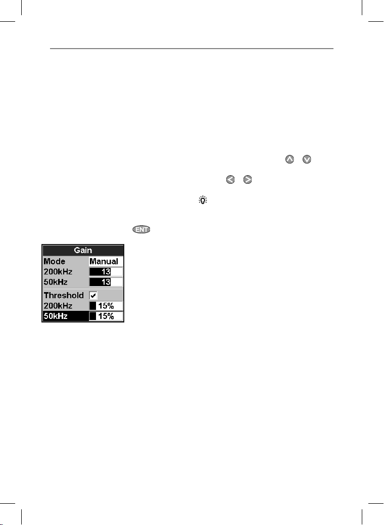
8-6 Gain a nd threshold
Gain and threshold settings control the amount
of detail displayed on a sonar display:
Gain: The gain of the sonar receiver. The gain
should be high to display good detail, but if the
gain is too high then information from the strong
bottom signal is lost and false echoes might be
displayed. There is a separate gain setting for
each sonar frequency, 50 kHz and 200 kHz.
Threshold: Return echoes less than the
threshold are ignored. The threshold should be
as low as possible, but if the threshold is too low,
unwanted noise will be displayed. Threshold is
set as a percentage of gain. For example, if the
threshold is 50 %, then return echoes less than
50 % of the maximum signal are ignored. There
is a separate threshold setting for each sonar
frequenc y, 50 kHz and 200 kHz.
The gain wind ow
To display or change the current settings for gain,
select a sonar display and press . Select
Threshold to display the thresholds.
This display is called the gain window.
Changing mode
The 657 has three operating modes, In Cruising
and Fishing modes, the 657 automatically adjusts
gain and threshold for good performance. In
manual mode, you can hand adjust the settings.
To change the mode from the Gain window,
Select Mode and then selec t Fishing,
Cruisi ng or Manual. When you select
Manual, the 657 reverts to your last manual
settings.
Changing gain and threshold
1 In the Gain window, press
the setting to adjust.
2 Press
or adjust the setting. The 657
changes to Manual mode.
Tip: Use the A-scope window to help set gain
or threshold manually (see section 9 -5).
or to select
39Northstar Explorer 657 Installation and Operation Manual
Page 40
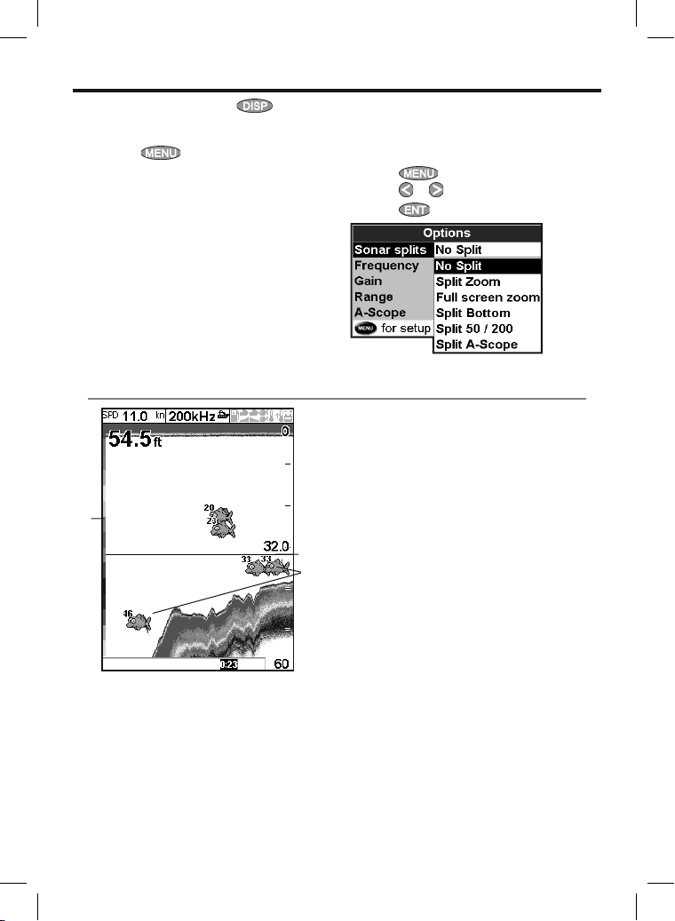
9 Sonar fishfinding: Displays
To show the Sonar display, press , then
select Sonar.
There are five kinds of sonar display. To use a
display, press
then selec t the type of display to use:
No split: Sonar histor y display at a single or
mixed frequency (see section 9-1).
Split zoom: Sonar histor y plus a zoomed section
(see section 9-2).
Full screen zoom: See section 9-2.
Split bottom: Sonar histor y plus a bottom trace
in a zoomed section (see section 9-3).
Split 50/200: Sonar histories at 50 and 200 kHz
(see section 9- 4).
9-1 Sonar history d isplay - no split
A
B
C
, select Sonar splits,
G
F
Split A-Scope: Sonar histor y plus echo strength
(see sec tion 9-5).
If the display is split, adjust the split ratio if
required:
1 Press
2 Press
3 Press
A Optional data header (see section 2-7-3)
B Depth
C Color bar
D Bottom
E Range
F Fish symbols with depth
G Depth line
The window scrolls from right (most recent
echoes) to left (oldest echoes).
and selec t Sonar display split.
or to adjust the ratio.
.
D
E
Northstar Explorer 657 Installation and Operation Manual40
Page 41
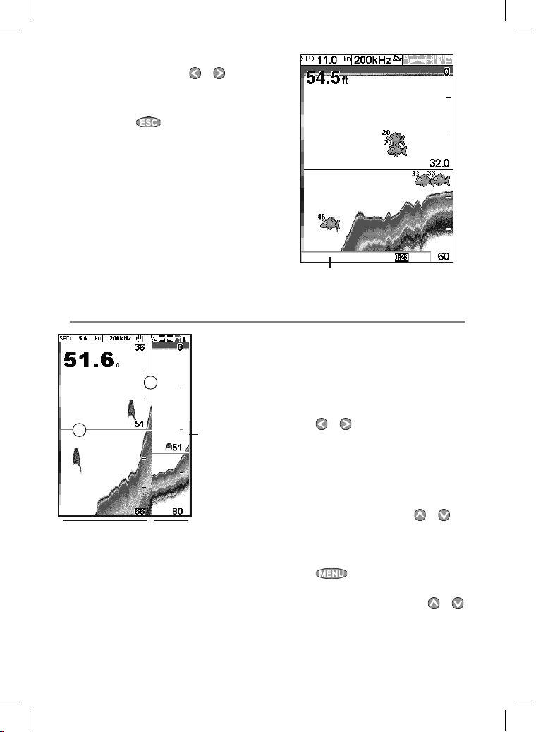
9-1-1 Extended h istory mode
To review an old sonar echo, use or to
move back and forward through the sonar
history. The time since the echoes shown on the
screen were recorded is displayed at the bottom
of the screen. Press to return to the most
recent echo.
The digital depth shown is always the current
depth, even in extended history mode.
The Histor y Position Bar indicates the age of the
most resent echo on the screen, and the position
of the current screen in the recorded histor y.
9-2 Sonar Zoom and Full Scree n Zoom displays
A
B
DE
A Divider line
B Depth line mark s the center of the zoomed
area
C Zoom bar
D Zoom section
E Sonar history
C
History position bar
These windows show a zoomed section of the
sonar histor y. The Sonar Zoom display shows
the sonar history on the right and the zoomed
section on the left. The Full Screen Zoom display
shows the zoomed section only.
The zoom bar on the far right shows the area of
the history that is magnified in the zoom section:
• Press
• If Bottom lock is on, the zoom depth
If Bottom lock is off, press
Bottom lock
To turn Bottom lock on or off:
1 Press
2 Select On or Off.
or If Bottom lock is on, pressing
or to adjust the zoom range
(the range of depths included in the zoom
section).
(the depth of the zoom section) is adjusted
automatically so that the bottom is always
displayed in the zoom section.
or to
manually adjust the the zoom depth.
and selec t Bottom lock.
or
will turn it off.
41Northstar Explorer 657 Installation and Operation Manual
Page 42
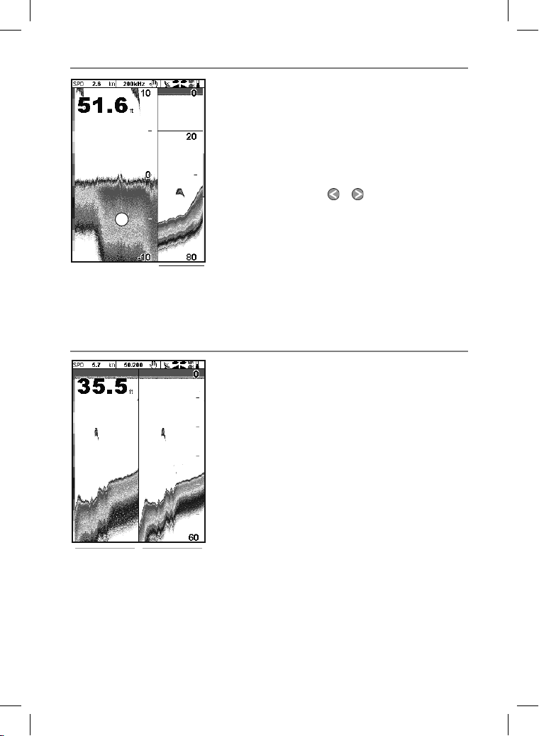
9-3 Sonar Bottom d isplay
A
A Zoomed bottom signal
B Sonar history
9-4 Sonar 50/ 200 display
The display shows the sonar history on the right
and the bottom signal as a flat trace in the center
of the zoom section on the left. The flat trace
make it easy to compare the echo strengths
shown in the bot tom signals. This can help to
identify the type of bottom and objec ts close to
the bottom.
The zoom bar on the far right shows the area of
the history that is magnified in the zoom section:
• Use the
range.
• The 657 calculates the zoom depth
automatically.
It is not necessary to turn Bottom lock on for this
B
display.
The display shows:
A the 50 kHz sonar history on the left
B the 200 kHz sonar history on the right.
Gain can be set independently for each
frequenc y (see section 8- 6). Range applies to
both frequencies (see section 8-5).
or keys to adjust the zoom
A
B
Northstar Explorer 657 Installation and Operation Manual42
Page 43
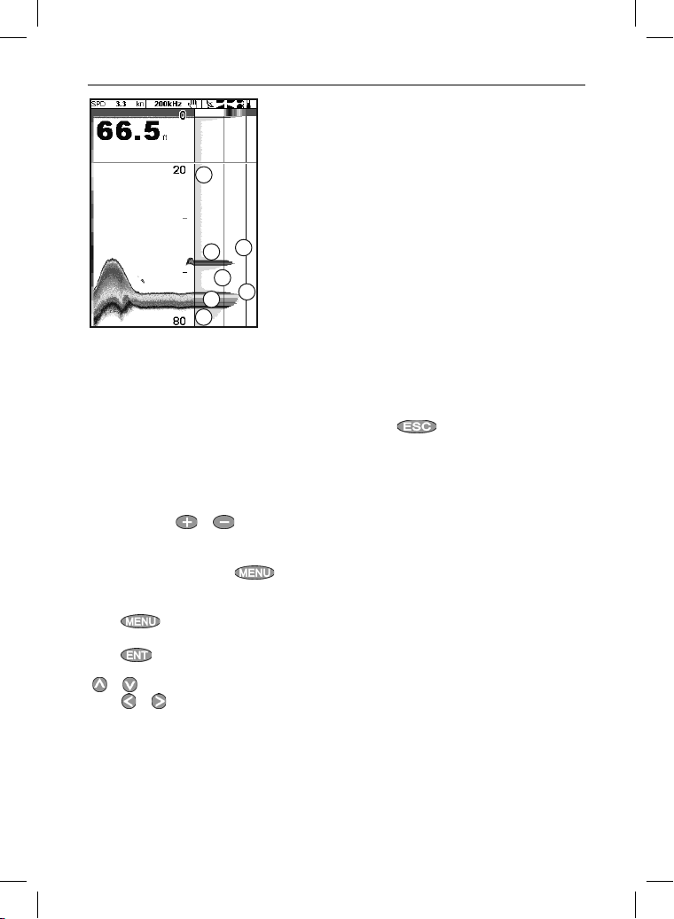
9-5 Sonar A-Scope display
A
A
The display shows the sonar history on the
left and the A-Scope display on the right. T he
A-Scope shows:
A, B, C The strengths of echoes being received
now from dif ferent depths - the longer the
horizontal line the stronger the signal:
A Unwanted noise echoes.
B Echoes from fish and the bottom
E
B
D
C
B
C The strongest echo, usually from the
bottom
D A vertical line showing the threshold, the
weakest echo to display on the sonar history
E A vertical line showing the gain setting;
echoes above this strength will display as the
maximum signal strength
Use the A-Scope while adjusting the gain and
threshold set tings manually (see section 8-6).
Setting ga in and threshold
It is convenient to use the A-scope display when
adjusting gain and threshold manually. Follow
this procedure to adjust gain and threshold for
normal circumstances:
1 Switch to a sonar display (see section 9). If
necessary, press
so that the bottom is displayed.
2 If necessary, select the sonar frequency to
adjust the settings for. Press
Frequency and selec t 200 kHz or 50
kHz.
3 Press
Split A-scope.
4 Press
adjust gain or threshold for a frequency, press
or to select the setting to adjust, then
press or to change the set ting.
5 Set threshold to zero.
6 Adjust Gain so the peak of the strong signal
from the bot tom just touches the gain line.
7 Adjust threshold so that it is just to the right
of the noise.
or to adjust range
, select
, select Sonar splits then select
to display the Gain window. To
8 Press
9 If required, repeat these steps to adjust gain
and threshold for the other frequency.
Note: Setting the gain higher will display more
detail from weak echoes, like fish, but will loose
detail from the strong echo from the bottom.
to close the gain window.
Fish recogniti on
The echo strengths shown on the A-scope can
be useful in recognising the type of fish. Different
species of fish have different sizes and shapes
of swim bladders. The air in the swim bladder
reflec ts the ultrasonic pulse, so the strength of
the echo varies between fish species according to
the size and shape of the swim bladder.
When catching fish from a school, note the
species and the strength of the echo that
it returns on the A-scope. Then, when that
particular echo is seen again, it is likely to be the
same fish species.
Bottom typ e
The shape of the echo strengths in the A-Scope
can help you to recognise the type of bot tom.
43Northstar Explorer 657 Installation and Operation Manual
Page 44
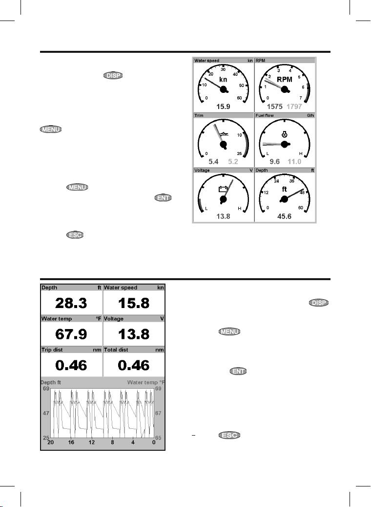
10 Gauges window
The Gauges window shows boat data, such as
water speed, as analog gauges. To select the
Gauges window, press , select More, then
select Gauges. Before using the Gauges window,
set Speed range, Max RPM and Max fuel f low (see
section 17-12).
Selecting a Gauges layout
To select a layout from the Gauges window, press
, select Layout, then select a layout from
the list.
Changing a gauge layout
You can change the data displayed on each
gauge in a layout.
1 Select the layout to change (see above).
2 Press
3 Highlight the gauge to change. Press
and selec t the data to display in the gauge.
4 Repeat the above step to change other
gauges.
5 Press
and select Gauge setup.
.
11 Da ta wi n do w
The data window has large numeric data fields
and a graph of depth and water temperature if
available. To go to the data window, press ,
select More, then select Data.
To select what data is displayed:
1 Press
2 Change a data field:
i Press the cursor keys to highlight the
ii Press
iii Selec t a data item that is available on your
3 Repeat the above step to set the other data
fields.
4
Press .
and selec t Data setup.
field.
to display a menu of data
items.
system or select None to leave the field
empty.
Northstar Explorer 657 Installation and Operation Manual44
Page 45
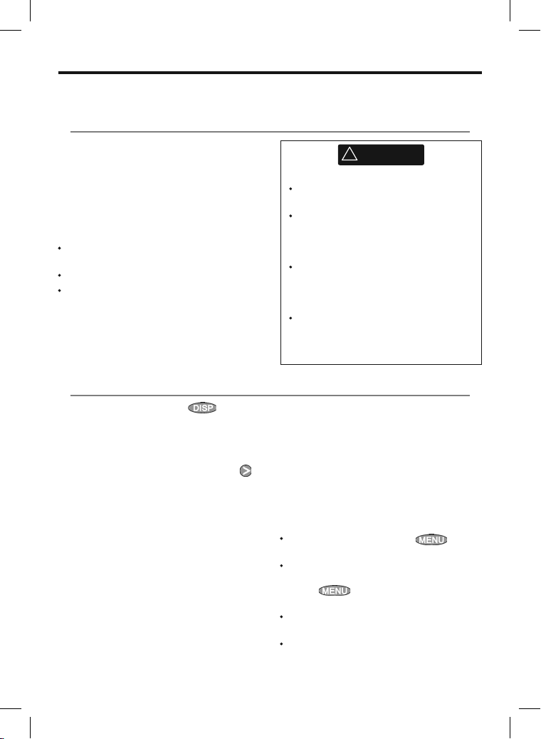
12 Fuel functions and display
The Fuel functions require optional petrol/gasoline or SmartCraf t™ fuel sensors to be installed and set
up.
12-1 Wh at the fuel computer d oes
Each engine has a f low sensor installed to
measure the engine’s fuel flow.
The 657 uses these f lows, together with boat
speed and engine RPM if available to estimate the
fuel remaining in the tank(s), fuel used, range and
fuel economy. This data is displayed on the fuel
window (see section 12-2).
You c an:
display the fuel used during a trip
(see section 12-2)
set low fuel alarms (see section 12-4)
make fuel consumption curves - graphs
of fuel consumption and boat speed as a
function of engine RPM - to monitor and
optimise boat performance.
(see section 12-6)
12-2 Fuel window
To go to the Fuel window, press , select
More, then select Fuel.
The display differs according to the number of
engines and tanks. If engine RPM is available
and if you have made and selected a Fuel
Consumption Cur ve (see section 12-6), press
to switch between a Summary or a Fuel curve
display.
The Fuel window sho ws
Speed
To selec t a boat speed s ens or, see section 12-5-1.
RPM (if available)
If engine RPM is not available, the display shows
depth.
Remaining
The fuel remaining in the tank(s) is shown as a
vertical gauge on the right of the display. The
height of the yellow bar(s) show how much fuel
remains in the tank(s). If you have set a low fuel
To ensure the fuel data is accurate:
When you add or remove fuel from a
tank, tell the 657 (see section 12-3)
If the boat has petrol/gasoline sensors,
calibrate them during installation or if
the fuel readings seem inaccurate (see
section 12-7)
Choose an appropriate type of boat
speed sensor to calculate economy,
range and the fuel consumption curve
(see sec tion 12-5)
If the boat uses a paddlewheel sensor
to measure speed, calibrate it during
installation or if the speed readings seem
inaccurate.
alarm (see section 12-4), a red bar shows the level
at which the alarm will trigger. If there are two
tanks, the left bar shows the por t tank, the right
bar shows the starboard tank.
Used
The fuel used during a trip. On a multi-engine
boat, the data for the por t engine is on the left of
the display.
When you want to start measuring how much
fuel is used, go to the Fuel window and:
In a single engine boat, press and
select Clear used.
In a multi-engine boat, the fuel used by each
engine and the total fuel used are shown.
Press , select Clear u sed and
select:
Port or Starb oard to clear the fuel used
by one engine
Both to clear the total fuel used.
!
WARNING
45Northstar Explorer 657 Installation and Operation Manual
Page 46
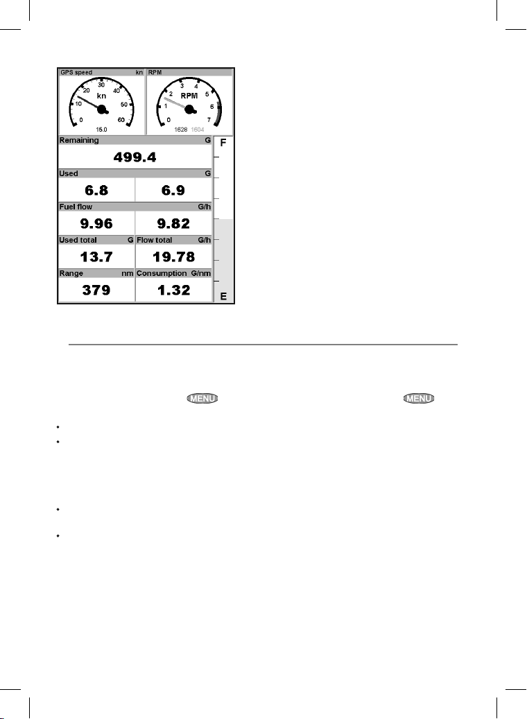
Fuel window
12-3 When you add or re move fuel
When you add or remove fuel, you must tell the
657, otherwise the fuel data will be meaningless.
A When you completely fill a tank
Go to the fuel window and press
Then:
On a single-tank boat, select Fill ta nk.
On a multi-tank boat, select Fill tank,
then selec t the tank you have filled.
Note: Underf loor fuel tanks are often dif ficult to
refill to the same level twice, due to air pockets.
With underfloor fuel tanks:
Trim the boat to the same angle in the water
each time you follow procedure A.
Mostly use procedure B below when adding
fuel, but completely fill the tank and follow
procedure A about every tenth time you add
fuel.
.
Fuel flow
The fuel f low for the engine(s). On a multi engine
boat, the data for the por t engine is on the left
of the display. Use the f lows to check the load of
each engine.
Range
The estimated boat range at the current fuel
flow. The value can depend on the type of speed
sensor (see section 12-5).
Economy
The distance travelled per unit of fuel used. The
value can depend on the type of speed sensor
(see section 12-5). The larger the value, the better
the fuel economy. Adjust the throttle and trim to
achieve the best economy.
Fuel consumption curve
A graph of fuel consumption and boat speed
as a function of engine RPM. Use the curve to
monitor and optimise boat performance (see
section 12-6).
B When you partially fill a tank
1 Add fuel to a tank and write down how much
fuel you add.
2 From the Fuel window, press
select Add fuel.
3 On a multi-tank boat, select the tank that you
have added fuel to.
4 Change the number to the amount of fuel
that you added.
Note: If you follow procedure B ever y time you
add fuel, then a small error will accumulate,
because it is hard to measure exactly how much
fuel you add. To avoid this, completely fill the tank
and follow procedure A about every tenth time
you add fuel.
and
Northstar Explorer 657 Installation and Operation Manual46
Page 47
C When you remove fuel
1 Before removing fuel, go to the Fuel window,
press
2 On a multi-tank boat, select the tank that you
are removing fuel from.
3 Write down the value of Remaining for the
tank; this is the amount of fuel originally in
the tank.
4 Remove fuel from the tank and write down
how much fuel you remove.
5 Subtract the amount of fuel you removed
from the amount of fuel originally in the tank
to calculate the amount of fuel now in the
tank.
and selec t Set remaining.
12-4 Low fuel alarm
To set a low fuel alarm for a tank:
1 Press
Setup tanks.
2 On a multi-tank boat, select the tank to set
the alarm for.
3 Select Tan k
trigger the low fuel alarm.
twice, select Fuel then select
alarm and enter a fuel level to
12-5 Boat speed senso rs
12-5-1 Selecting a boat spee d sensor
The fuel calculations can use boat speeds from
the GPS, or from a paddlewheel sensor or pitot
sensor if these optional sensors are installed:
Paddlewheel and pitot sensors measure the
speed through the water; GPS speed is speed
over ground; these sensors can give different
values for Range, Economy and the fuel
consumption curves (see section 12-5-2).
A pitot sensor is more accurate than a
paddlewheel sensor at high speeds but is
not accurate at low speeds. A paddlewheel
sensor is more accurate than a pitot sensor at
low speeds.
6 Change the number on the Set Remaining
menu to the amount of fuel that you
calculated was now in the tank .
7 Press
Note: You can also use this procedure when you
add fuel to a tank. In this case, add the fuel you
have added to the amount of fuel originally in
the tank to calculate the amount of fuel now in
the tank.
When a low fuel alarm is set, the alarm’s fuel level
is shown on the fuel window tank levels as a red
bar. The alarm can also be set using the Alarms
setup menu (see section 17-9)
To select an optional speed sensor
1 Press
Speed source.
2 To use a paddlewheel or pitot sensor, select
Water speed, otherwise select Ground
speed to use GPS speed.
3 If you selected Water speed and you have
both a paddlewheel sensor and a pitot
sensor:
i Press
ii Select Padd lewheel or Pitot.
Tip: You can select a different speed sensor
during a trip.
twice, select Fuel and select
, select SmartCraft and
select Speed type
47Northstar Explorer 657 Installation and Operation Manual
Page 48
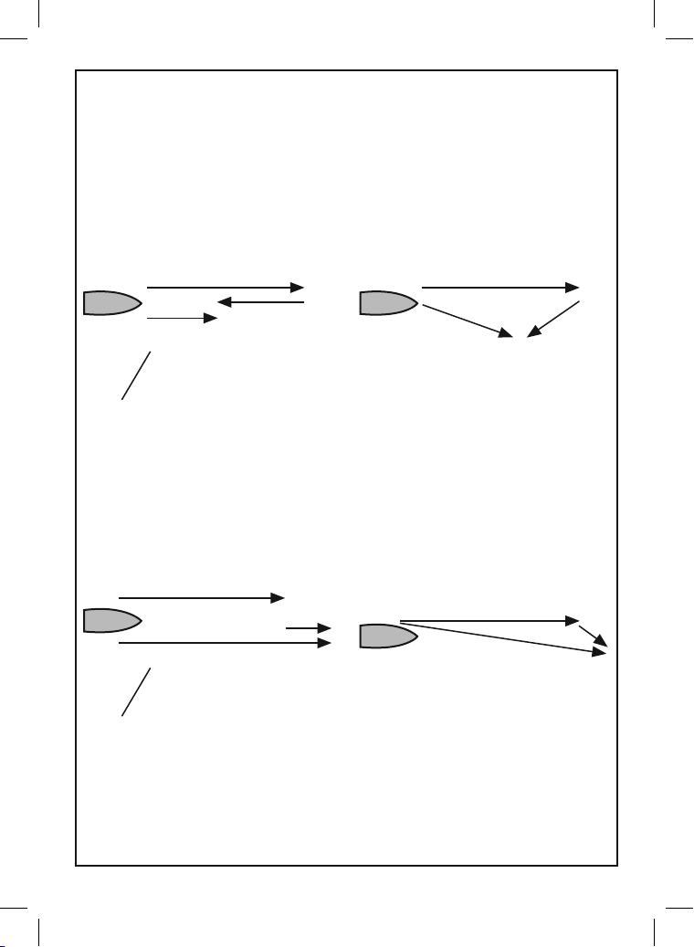
12-5-2 Water speed and grou nd speed
A paddlewheel sensor and a pitot sensor
measure water speed, the boat speed through
the water. A GPS measures ground speed, the
boat speed over the bot tom of the water. If
there is a current, then these speeds will be
different, and the log, trip log, economy and
range will be different, as shown below.
When the current is from ah ead, ground speed is less than water speed
Water speed 10 knots
Water speed is better for measuring the boat’s
potential performance, Ground speed is better
for going to a destination because it takes
currents into account. To select a speed sensor,
see section 12-5-1.
Water speed 10 knots
Current 4 knots
Gives a ground speed of 6 knots
For this example:
If the boat travels for one hour, uses 3 gallons of fuel per hour and has 50 gallons of fuel left:
Speed Log Economy Range
Using water speed: 10 knots 10 nm 3.3 nm / gal 165 nm
Using ground speed: 6 knots 6 nm 2.0 nm / gal 100 nm
When the current is from behind, g round speed is m ore than water sp eed
Water speed 10 knots
Current
4 knots
Gives a ground speed of 14 knots
For this example:
If the boat travels for one hour, uses 3 gallons of fuel and has 50 gallons of fuel left:
Speed Log Economy Range
Using water speed: 10 knots 10 nm 3.3 nm / gal 165 nm
Using ground speed: 14 knots 14 nm 4.7 nm / gal 235 nm
Gives a ground speed
of about 8 knots Current 4 knots at 45º
Water speed 10 knots
Gives a ground speed of about 13 knots
Current 4
knots at 45º
Northstar Explorer 657 Installation and Operation Manual48
Page 49
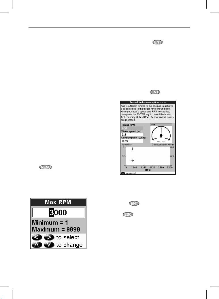
12-6 Fuel consumption cur ves
A fuel consumption curve shows fuel
consumption (fuel used per unit of distance
travelled) and boat speed as a function of
engine RPM. Fuel consumption cur ves require
engine RPM, which requires SmartCraft™ or
diesel sensors to be installed. Fuel consumption
curves are powerful tools for assessing boat
performance in dif ferent conditions and for
helping you to run at the most economical speed
and trim for the conditions.
12-6-1 Making a fue l consumption cur ve
To make a fuel consumption curve you will need
to run the boat in a straight line for about 15
minutes using the engine’s full RPM range. For
your first curve, choose a calm day with light
wind and little current; have a typical load and
a freshly cleaned hull. Later, you can make fuel
consumption cur ves for different boat, weather
or sea conditions. Compare these with your
first cur ve to see how your boat’s per formance
changes with conditions.
Making a curve
1 Start running the boat in a straight line.
2 Choose a speed source for the curve (see
section 12-5-1). Normally choose Water speed
to measure the boat ’s potential per formance.
3 Press
4 Select Fuel consum ption cur ve, then
select New.
5 Enter the comfortable maximum RPM you
know you can achieve for the engine rather
than the maker’s value.
twice, then select Fuel.
Now, do not change the engine speed.
Wait for about 60 seconds for the boat to
stabilise, then press . Wait while the fuel
computer records the data.
7 The 657 then asks you to set the throttle to
achieve a vessel RPM. On a multi engine boat
set all engines to about the vessel RPM. When
the engine RPMs are correct, the Vessel RPM
box will turn green.
Now, do not change the engine speed.
Wait for about 60 seconds for the boat to
stabilise, ensuring the Vessel RPM box stays
green. Then press
computer records the data.
8 The 657 repeats the above step to record data
up to the maximum RPM. Then the 657 ask s
if you want to save the curve. Select Ye s. The
fuel computer asks for a name for the cur ve.
Change the default name if required. Then
press . The 657 stores the new curve.
Note: To interrupt making the curve at any time,
press
.
. Wait while the fuel
6 The 657 then asks you to set the minimum
RPM. Set the throttle to idle; on a multi
engine boat set all engines to about the same
idle RPM.
49Northstar Explorer 657 Installation and Operation Manual
Page 50
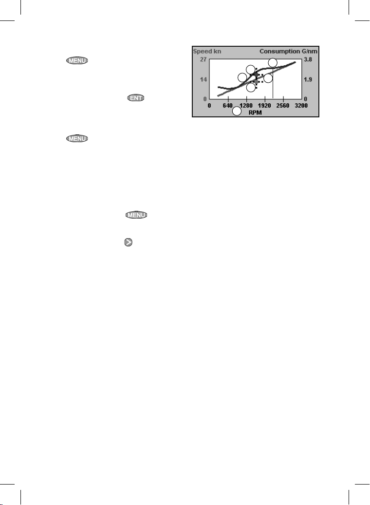
12-6-2 Managing fuel consu mption curves
Renaming a curve
1 Press
2 Select Fuel consum ption cur ve.
Select Name and select the name of the
curve to rename.
3 Select Rename and press
the name.
twice, then select Fuel.
. Change
12-6-3 Using fuel consumptio n curves
Deleting a curve
1 Press
2 Select Fuel consumption curv e.
Select Name and select the name of the
curve to delete.
3 Select Delete.
Selecting a curve
1 You must make a fuel consumption curve
before you can use it (see section 12-6-1).
2 On the Fuel window, press
Fuel consumption curve and select the name
of the curve to use.
3 On the fuel window, press
to select Fuel curve and display the fuel
consumption curve.
Note:
a On a multi engine boat, keep the RPM of all
engines similar while using a curve.
b The shape of the curve depends on the type
of speed sensor you selected when making
the curve (see sections 12-5-1 and 12-5).
twice, then select Fuel.
, select
if necessary
Using a curve
F
E
D
B
C
A
Compare your boat’s performance now, at the
current RPMs, with the boat’s performance when
you made the curve. You can compare your
boat’s per formance now with a curve made
under ideal conditions or with a curve made
under similar conditions.
Inform ation in a curve
A RPM of the boat now. For a twin engine boat,
the RPM is the average of the two RPMs.
B Red cur ve: boat speeds at dif ferent
RPMs recorded when you made this fuel
consumption curve.
C Red marker: the boat speed now. This marker
is below the red curve, showing that the boat
speed now at this RPM is less than when you
recorded the curve.
D Blue curve: fuel consumption at different
RPMs recorded when you made this fuel
consumption curve.
E Blue marker: the fuel consumption now. This
marker is below the blue curve, showing
that the fuel consumption now at this RPM is
better than when you recorded the curve.
F If the blue curve has a dip, then running the
boat at this RPM will give the best speed for
the least fuel consumption.
Northstar Explorer 657 Installation and Operation Manual50
Page 51
12-7 Cal ib rat ion
Calibrate petrol/gasoline fuel flow sensors
during installation, or if the fuel readings seem
inaccurate and the other troubleshooting
suggestions do not help (see appendix B
troubleshooting).
Note
SmartCraft™ fuel sensors are factory
calibrated and should never need
recalibrating.
On a multi engine boat, calibrate each
engine’s sensor. This can be done at the same
time with a portable tank for each engine or
at different times using one portable tank.
Calibrating a sensor requires accurate
measurement of the fuel consumption.
This is best done using a small por table tank.
At least 4 gallons (15 litres) of fuel should be
used to ensure an accurate calibration.
It is often very difficult to fill underf loor tanks
to the same level t wice due to air pockets, so
the more fuel used, the more accurate the
calibration.
To calibrate the sensor(s):
1 Record the level of the fuel in the tank(s).
2 Connect the por table tank(s) to the engine
through the fuel sensor(s).
3 Run the engine at normal cruising speed until
at least 4 gallons (15 litres) of fuel has been
used per engine.
4 Check the actual amount of fuel used per
engine by refilling the por table tank(s) to the
original level and noting the reading(s) of the
fuel dispenser’s gauge.
5 Press
Setup engines.
6 On a single engine boat, select Calibrate
and change the displayed value to be equal
to the reading of the fuel dispenser’s gauge,
then press
On a multi-engine boat select the engine.
Select Calibrate and change the
displayed value to be equal to the reading of
the fuel dispenser’s gauge, then press
Repeat for the other engines.
twice, select Fuel then select
.
.
51Northstar Explorer 657 Installation and Operation Manual
Page 52
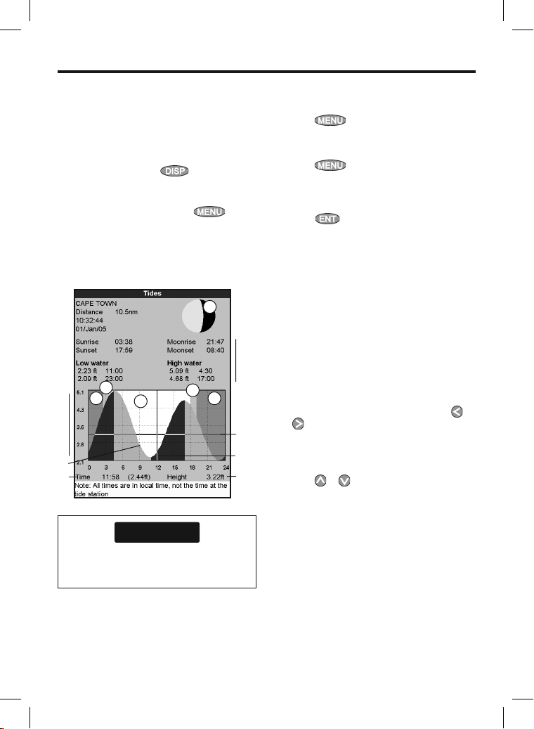
13 Tides window
The tides window is available on C-MAP charts.
The tides window shows tide information at a
tide station for the selected date.
Note: The tides window requires the local time
offset to be set to work correctly (see sec tion
17-13 )
To show the tides window for the tide station
nearest to the boat, press
then select Tides.
To go to the tides window for any tide station:
1 From the chart window, press
select Find.
2 Select Tide statio ns.
The tides window shows data for the chosen date
A
B
E
D
C
H
J
F
CAUTION
The tides window requires the local time
offset to be set to work correctly (see sec tion
17-13 )
, select More,
and
N
G
D
K
L
I
M
3 A list of tide stations are displayed. Selec t the
tide station to display. The chart redraws with
the tide station centred.
4 Press
5 Select Tide height.
Choosing the date of the tide chart
1 Press
2 Select Today, Next day or Prev day.
To choose a different date from these, select
Set date, edit the date,
press
A Tide station name and distance from boat
B Current time and chosen date for display
C Tide chart
D Night
E Dawn
F Day
G Dusk
H Tide height
I Time cursor, a vertical dotted line. Press
to move cursor sideways
J Time of cursor and tide height at that time
K Data for the chosen date
L Tide height cursor, a horizontal dotted line.
Press
M Height of cursor on the tide char t
N Moon phase for moon at the current time on
the chosen date
and selec t Chart info.
.
.
or to move cursor up and down.
or
Northstar Explorer 657 Installation and Operation Manual52
Page 53
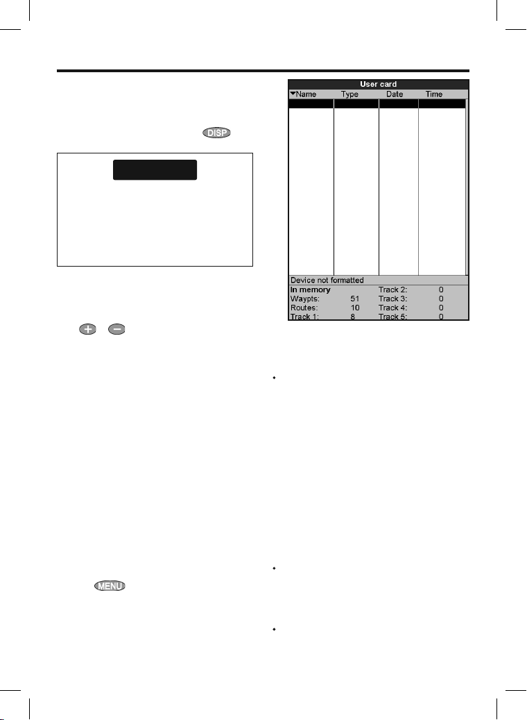
14 User card window
A C-MAP™ user card is an optional plug-in card
that can store data files (see section 1-3). There
are three types of files: waypoints, routes or a
track.
To go to the user card window, press
select More, then select User c ard.
CAUTION
1 Before using a user card, remove any chart
card and plug the user card in. When you
have finished with the user card, remove
the user card and replace the char t card
(see section 1-3).
2 The older 5 volt cards are not supported.
The user card wind ow has:
File list
A list of the files on any user card in the 657. If
there are more files than will fit on the display,
press
or to scroll up or down a page at
a time.
Waypts, Routes
The number of waypoints and routes currently
in the 657.
Track 1 to Track 5
The number of points in tracks 1 to 5 currently
in the 657.
Note:
1 To save 657 data onto the user card, use the
Save command (see below).
2 Data stored on the user card and shown on
the file list is not available to be used by the
657 until loaded into the 657 with the LOAD
command (see below).
Saving data to the use r card
This saves all the 657’s waypoints, all the 657’s
routes or one of the 657’s tracks to one file on the
user card.
1 Press
2 Select Waypts, Routes or Tracks.
3 For Tracks, select the track number to save.
4 The new file is created. Change the name
if required. The new file appears in the
file list.
and selec t Save.
,
Loading da ta from the user card to the 657
This loads one file from the user card to the 657:
A waypoint s file: The new waypoints are
added to any existing waypoints in the 657.
If a new waypoint has the same name as an
existing waypoint but has different data, the
657 displays both waypoints. Select:
Skip: Do not load the new waypoint.
Replace: Load the new waypoint and
replace the existing one.
Skip all: Do not load any new
waypoints which have the same names
as existing waypoints.
Rplc all: Load all new waypoints
which have the same names as existing
waypoints; the new waypoints replace
the existing waypoints.
A routes file: The new routes are added to any
existing routes in the 657. If a new route has
the same name as an existing route but has
different data then the 657 ask s which route
to keep.
A track file: The new track will replace the
existing track in the 657.
53Northstar Explorer 657 Installation and Operation Manual
Page 54
To load a file to the 657:
1 Select the file to load.
2 Press
and selec t Load.
Deleting a f ile from the user card
1 Select the file to delete.
2 Press
3 Select Yes to confirm.
and selec t Delete.
Rereading t he file information
This reads the file names from the user card and
displays them. Reading does not load any file
data into the 657. You should not need to do this.
1 Press
2 Select Read.
and selec t Card.
Formatting the u ser card
Formatting prepares a user card for use. Format
the card if there is an error message saying that
the card is not formatted. Any data files on the
card are deleted.
15 AIS
AIS is short for Automatic Identification System.
The International Convention for Safety of Life At
Sea (SOLAS) requires all vessels greater than 300
tons and all passenger vessels to be equipped
with AIS Transponders. All vessels equipped with
AIS permanently broadcast via one or more of the
two dedicated VHF channels. This transmission
may include information about the vessels MMSInumber, its call sign, name, position, course,
heading, speed, rate of turn and type of vessel.
This unit can receive and display AIS information
when connected to an AIS receiver. Available AIS
vessels transmitting in the local area are show on
the chart when this feature is enabled.
1 Press
2 Select Format.
3 Select Yes to confirm.
and selec t Card.
Sorting th e file names
This sorts the displayed file names.
1 Press
2 Select sort by Na me, Ty pe or Time.
Do not format a chart card.
The following AIS receivers are supported by
this unit:
• Comar SLR20 0 (external GPS).
• Weatherdock Two Channel AIS Receiver “EASY
AIS”, Part No. 5-A-013 (external GPS).
• NASA Marine AIS Engine 2 channel Receiver
(external GPS).
Other AIS receivers may work but have not been
tested with this unit.
To enable AIS from the system menu check the
AIS box. (see section 15-1)
and selec t Sort.
!
WARNING
Northstar Explorer 657 Installation and Operation Manual54
Page 55
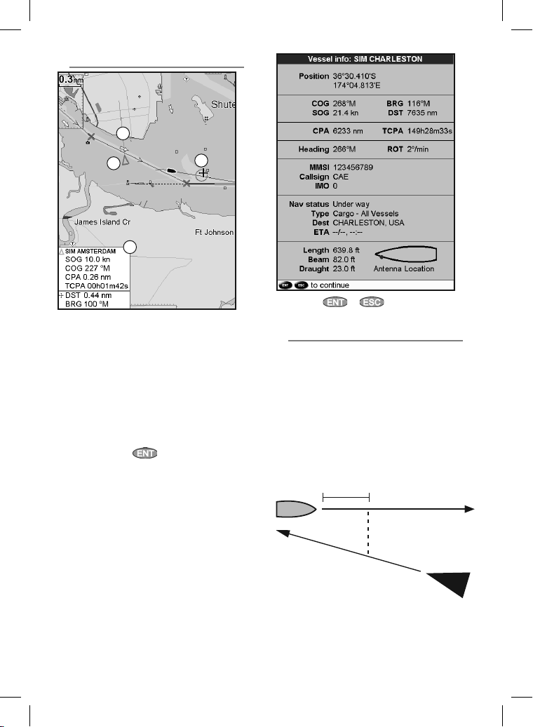
15-1 Viewing AIS Vessels
C
A
D
A AIS Vessel
B Dangerous Vessel
C Projected Course
D Data Box
When the cursor is placed over an AIS vessel for
at least two seconds, a data box appears at the
bottom of the window with information about
the AIS vessel.
For complete AIS information on the AIS vessel
place the cursor over an AIS vessel for at least two
seconds and press
B
.
Press either or to clear the
information.
15-2 Dangerous Vessels
The 657 calculates the time of closest point of
approach (TCPA) and closest point of approach
(CPA) for each AIS vessel.
This is used to determine potential dangerous
vessels. If the TCPA and the CPA is below
the trigger values then it will be considered
dangerous. (See section 17-9 for setting the
dangerous vessel alarm)
A dangerous vessel is indicated on the chart by a
red circle around the icon.
TCPA 15 min
CPA 0.5 nm
55Northstar Explorer 657 Installation and Operation Manual
Page 56
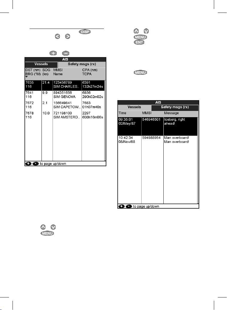
15-3 AIS Windows
To go to the AIS windows, press , select
More, then press or to select one of the
two windows: Vessels or Safet y msgs (rx).
If there are more items than will fit on the
window, press
or to see the others.
Vessels
This is a sorted list of vessels currently being
received by the AIS receiver. The maximum
number of vessels that the system will support is
250. Once maximum is reached, vessels furthest
away from the current location will be replaced.
A vessel will be removed from the list if no
information is received within 6 minutes from the
last message.
Displaying a n AIS vessel on the chart
1 Press
2 Press
or
to select a vessel.
Instrument switches to char t window, with
the selected vessel position in the middle.
and selec t Display. The
Displaying Ful l AIS Details
1 Press
2 Press
This window displays all information for
or
to select a vessel.
press .
the selected AIS vessel provided by the AIS
receiver.
and select More Info or
Sorting Vessel s
Press , select Sort and selec t one of
the options.
This sorts the list based on the chosen
category.
Safety msgs (rx)
Safety msgs (rx) are broadcasted messages
received by the AIS receiver. This window displays
the date and time of message received, MMSI of
AIS vessel that broadcasted the message, and the
message itself. Safety msgs (rx) list will store up
to 10 messages. The oldest message is replaced
when the list is full.
Northstar Explorer 657 Installation and Operation Manual56
Page 57
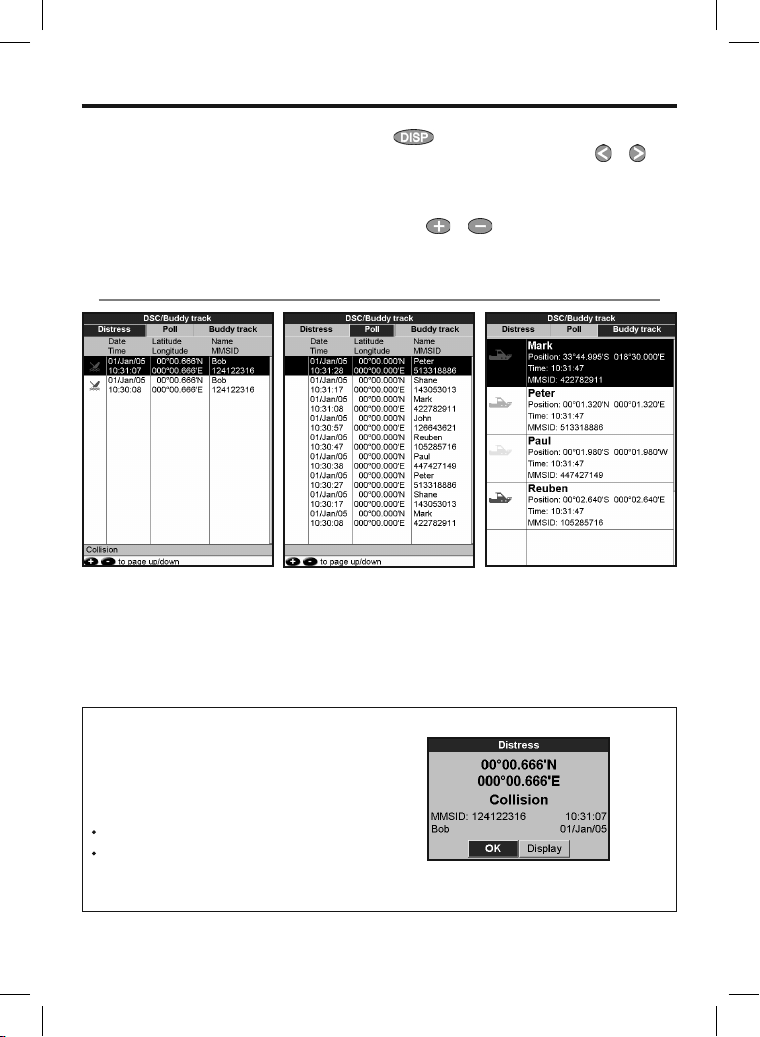
16 DSC/Buddy track windows
Buddy track requires an optional Northstar DSC
VHF radio to be installed. Buddy track tracks other
boats which have DSC radios connected to their
GPS receivers by NavBus and are in VHF range.
For information on setting up and using the VHF
radio for buddy track, see the radio’s operation
manual.
16-1 The displays
To go to the DSC/Buddy track windows, press
, select More, then select DSC. Then from
the DSC/BuddyTrack window press or to
select one of the three displays: Distress, Poll or
Buddy track.
If there are more items than will fit on the display,
press
or to see the others.
Distress
Boats that have sent DSC
distress messages and their
positions.
When your DSC radio receives a distress
message, the 657 creates a distress waypoint
at the boat position. Distress waypoints have
default names like DSTRSS01. The 657 displays a
Distress warning.
Select:
OK to return to what you were doing.
Display to switch to Chart and display the
position of the boat sending the distress
message.
Poll
Boats you have manually polled
on the VHF radio, and their
position at that time.
Buddy track
Buddy boats from your DSC
radio. The radio regularly calls
the boats and updates their
positions.
57Northstar Explorer 657 Installation and Operation Manual
Page 58
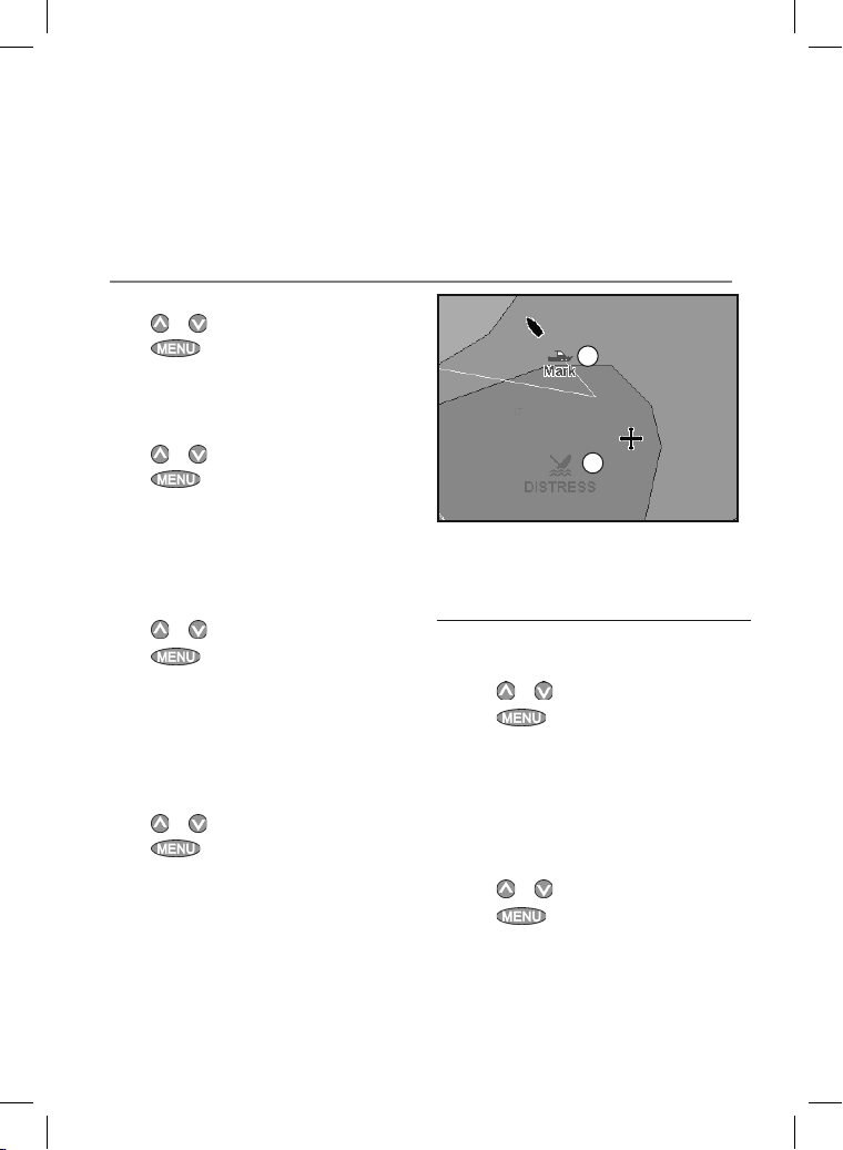
Boat positio ns
The boat positions on the 657 can differ from the
true boat positions:
Distress: The position is the distress waypoint,
which is where the boat was when it sent the
distress message.
16-2 Using the displays
Displaying a bo at on the chart
1 Press or to select a boat.
2 Press
switches to char t window, with the selected
boat position in the middle (see Boat
positions above).
and selec t Display. The 657
Going to a boat
1 Press or to select a boat.
2 Press
navigating to the boat’s position (see Boat
positions above).
and selec t Goto. The 657 starts
Creating a waypoint
Polled and buddy track boats are not waypoints.
To create a waypoint at the position of a polled
boat (see Boat positions above):
1 Press
2 Press
or to select a boat.
and selec t Create
waypoint. Edit the waypoint data if
required (see section 5-2-7).
Editing a waypo int
A distress message creates a waypoint for the
boat or you can create a waypoint at a polled
boat’s position. To change the data of these
waypoints:
1 Press
2 Press
or to select a boat.
and selec t Edit waypoint.
Edit the waypoint data if required (see section
5-2-7).
Polled boats: The position is where the boat
was when you last polled the boat.
Buddy track: The position is where the boat
was when your radio last polled the boat.
B
A
On a chart window:
A Distress boats are distress waypoints
B Buddy track boats are buddy symbols
Deletin g a boat
At the Distress or Poll displays:
1 Press
2 Press
Buddy track boats automatically disappear from
the Buddy track window when your DSC radio
can not pick up their signal.
or to select a boat.
and selec t Delete. The boat
is deleted from that display. Delete any boat
waypoint manually (see section 5-2-5).
Deletin g all boats
At the Distress or Poll displays:
1 Press
2 Press
or to select a boat.
and selec t Delete all. All
boats are deleted from that display and any
boat waypoints are deleted.
Northstar Explorer 657 Installation and Operation Manual58
Page 59
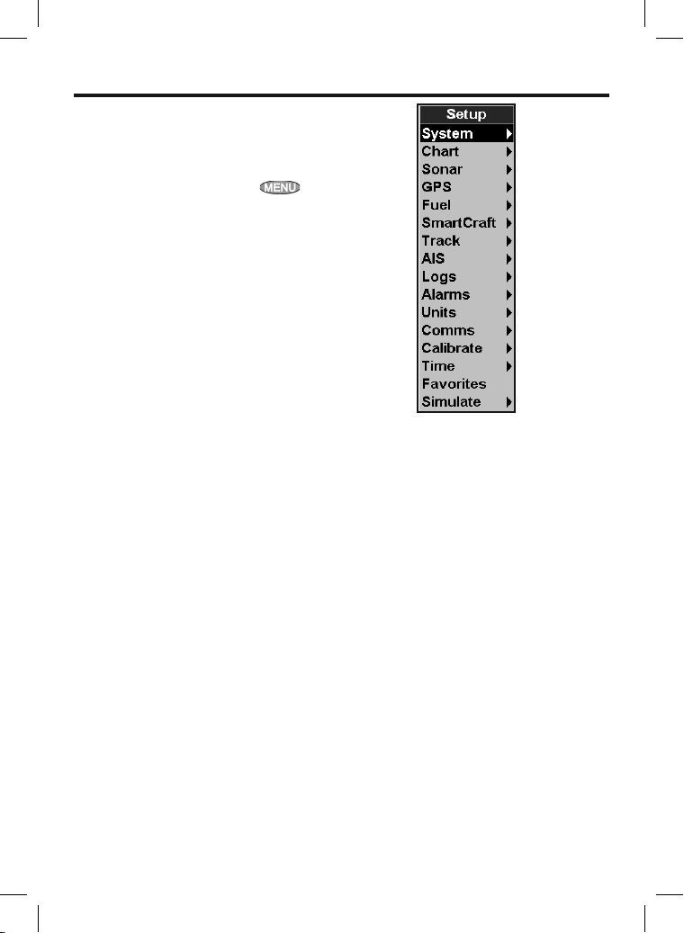
17 Setting up the 657
The 657 has a number of advanced features
which are set up through the setup menu. We
recommend that you become familiar with the
operation of the unit using the default set tings
before making any changes in these menus.
To go to a setup option menu, press
twice, then select an option.
Note:
1 The Setup menu options are explained in the
following sections.
2 Section 2-1 describes how to set or change
data in the setup menus.
3 The setup data available will depend on the
optional sensors and instruments installed.
59Northstar Explorer 657 Installation and Operation Manual
Page 60
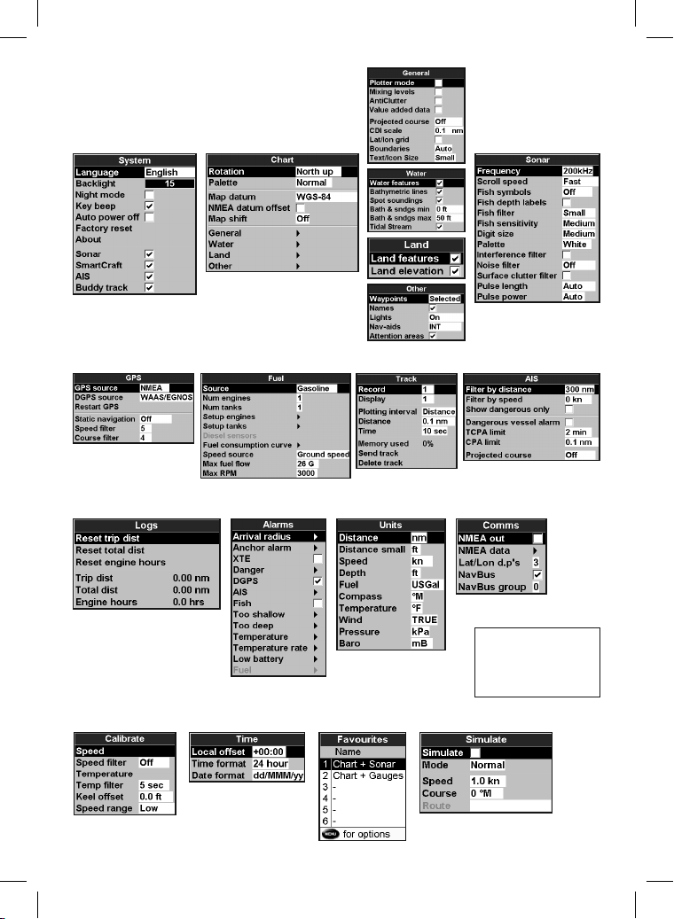
Setup option me nus
Factory default settings are shown. The setup data
available will depend on the optional sensors and
instruments installed.
System (see 17-1) Chart (see 17-2) Sonar (see 17-3)
General, Water, Land and
Other submenus (17-2)
Track (see 17-6)Fuel (see 17-5)GPS (see 17-4)
Alarms (see 17-9) Units (see 17-10) Comms (see 17-11)Logs (see 17-8)
Calibrate (see 17-12) Simulate (see 17-15)
Northstar Explorer 657 Installation and Operation Manual60
Favorites (see 17-14)Time (see 17-13)
AIS (see 17-7)
SmartCraft™
(See the SmartCraft™
Gateway Installation
and Operation Manual)
Page 61
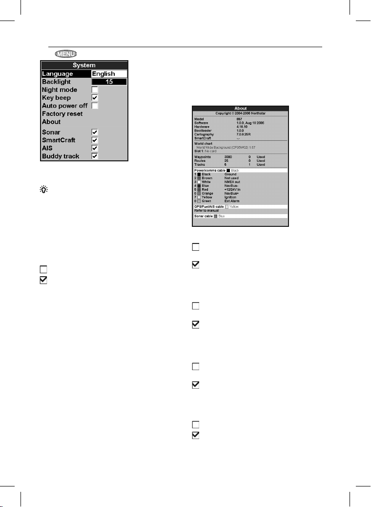
17-1 Setup > System
Press twice, then select System:
Language
Select the language for the displays.
Tip:
In case you can’t read the current
language, the language setting is found at the top
of the system menu.
Backlight
Select the backlight level for the keys and display
(see also section 2-3)
Night mode
Night mode sets the palette for all displays.
Normal palette, for daytime
All displays have a palette optimised for night
time.
See also section 2-3. To change only the chart
palette, see section 17-2.
Key beep
Enables or disables the beep when a key is pressed.
Auto power off
See section 2-2.
Factory reset
This option returns all of the 657 settings (except
the language, waypoints and routes) to the default
factory settings shown on the setup menus.
About window
The about window shows:
• The software version and date.
• The world chart version.
• Any card fitted.
• The number of waypoints, routes and tracks
you have stored.
• Connector wiring information.
In the unlikely event of having to contact a
Northstar dealer for service, quote the software
version number and date.
Sonar
Disable any sonar transducer and disable sonar
functions.
A sonar transducer is fitted. Enable sonar
operation.
See section 18-6.
SmartCraft™
No SmartCraft™ gateway is fitted. Disable
SmartCraft™ functions.
SmartCraft™ gateway is fitted. Enable
SmartCraft™ operation.
See section 18-8.
AIS
No appropriate AIS receiver is fitted. Disable
AIS.
An appropriate AIS receiver is fitted.
Enable AIS.
See section 17-11.
Buddy track
No DSC VHF radio is fitted. Disable Buddy track.
A DSC VHF radio is fitted. Enable Buddy track.
See section 18-8
61Northstar Explorer 657 Installation and Operation Manual
Page 62
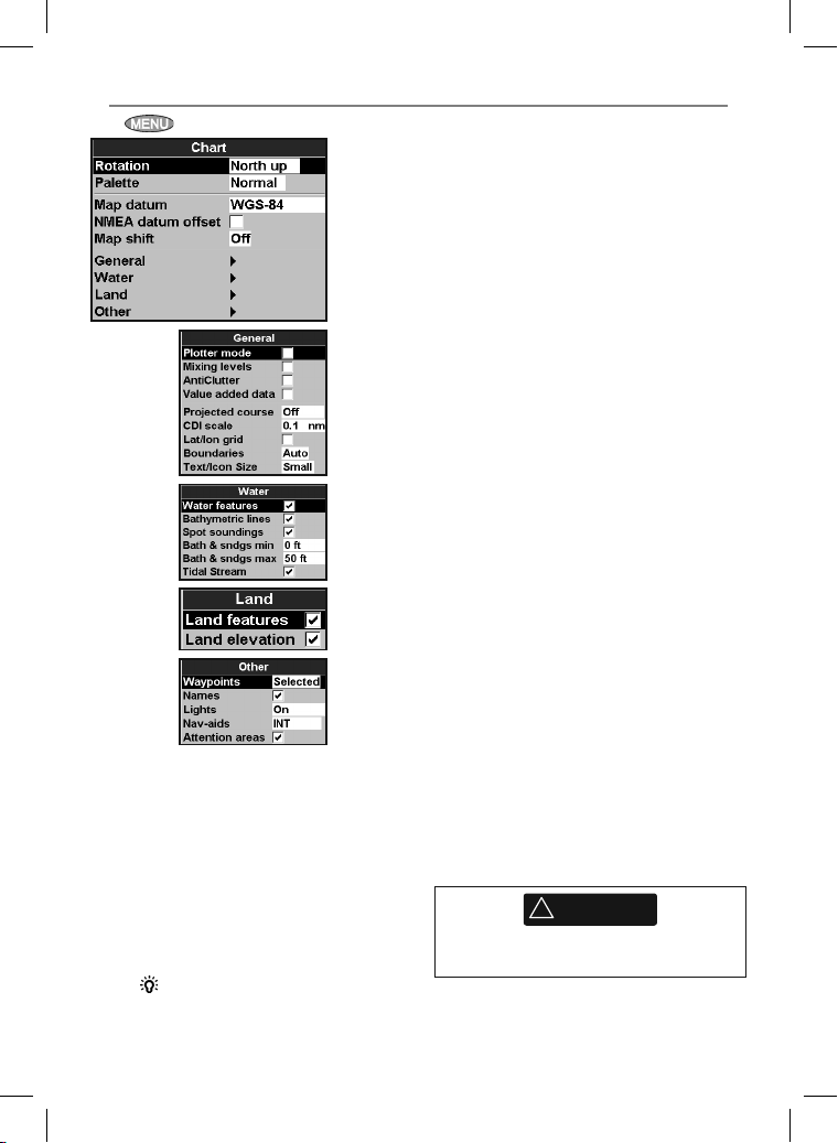
17-2 Setup > Chart
Press twice, then select Char t:
Rotation
The options for chart rotation are:
North up: North is always at the top of the
chart window.
Track u p: The chart is rotated so that the
boat direction is to the top of the display.
This option is useful for navigating narrow
harbours or rivers. The 657 asks for a course
deviation resolution; this is how much the
boat direction needs to change to make the
chart redraw.
Tip: If the chart redraws too
frequently, increase the course deviation
setting.
Northstar Explorer 657 Installation and Operation Manual62
Course up: This option is only available
if the boat is navigating to a destination. The
chart is rotated so that the plot ted course to
the destination is vertical.
Pale tte
Select the color scheme for the LCD display.
The options are:
Normal
Sunlight: Brighter colors, more visible in
sunlight.
Night: Reversed colors for night, to preserve
night vision.
Map datum
657 GPS positions are based on a worldwide
reference (datum) known as WGS 84. Most paper
charts are based on WGS 84. However, some
paper char ts are based on other datums In these
cases, the latitude and longitude coordinates of
objects on the 657 chart window are dif ferent
to the latitude and longitude coordinates of
these objects on the paper char t. This applies to
all objects, such as the boat, waypoints, tracks,
lines of latitude and longitude and cartographic
features such as land, rocks, buoys and depth
contours.
Use Map d atum to select the 657 map datum
to match the datum of the paper char t. Then, the
latitude and longitude coordinates of objects
displayed on the 657 will change to match the
corresponding coordinates on the paper chart.
Setting map datum
1 In the Chart setup menu, select Map
datum.
2 Select the map datum for the paper char t you
are using.
3 If you selec t a datum other than WGS 84
the 657 asks if you want to apply the NMEA
datum offset (see below).
!
WARNING
When you change to a chart with a different
datum, change the 657 map datum again.
Page 63
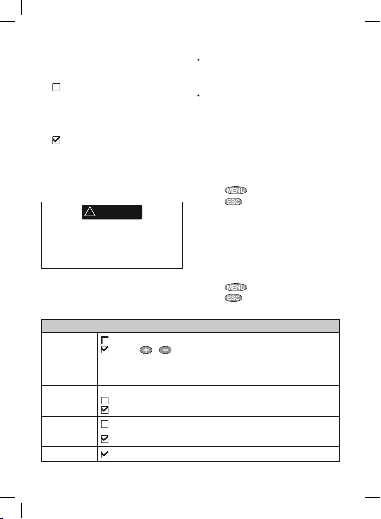
NMEA datum of fset
If you selec t a map datum other than WGS 84,
the map datum of fset can be applied to latitude
and longitude coordinates sent on the 657 NMEA
output:
Latitude and longitude coordinates
displayed on any NMEA repeater do not
match the coordinates on the 657. Latitude
and longitude coordinates broadcast on any
NMEA VHF transmitter will be the same as the
coordinates on a WGS 84 chart.
Latitude and longitude coordinates
displayed on any NMEA repeaters match the
coordinates on the 657. However, latitude
and longitude coordinates broadcast on any
NMEA VHF transmitter will be slightly offset
from coordinates on a WGS 84 chart.
Map shif t
!
WARNING
Map shift is for eliminating minor offsets.
It should not be used if the correct datum
is available. Use map shift with caution:
incorrect application will cause incorrect boat
positions.
General submenu
Plotter mode
Mixing levels
Anticlutter
Value added data
Normal: only scales available on the chart card can be displayed
If you press or to select a chart scale which is not available, on the chart card, the
chart window will change to this scale but will only display the boat position and track (if enabled).
The rest of the display is white with black crosshatch lines and no chart information is displayed. This
is useful to zoom to a small scale to track small boat movements or if there is no detailed chart for
an area
Mixes lower detail charts with higher detail charts on chart boundaries
Lower detail chart is not shown
Lower detail chart shown; this is slower to redraw
Names and icons shown. Note: this is independent of the change in detail shown at diff erent
zoom levels
Hides some less important names and icons to make the chart clearer
Non marine chart data shown
Some charts have consistent position erro rs. To
correct this, apply a map shift. Af ter a map shift:
The positions of cartographic features (such
as land, rock s, buoys and depth contours)
move on the 657 chart window to where they
should be.
The positions of the boat, waypoints, tracks,
and lines of latitude and longitude on the 657
chart window remain unchanged.
Applying a map shift
1 Move the boat to a known point on the chart,
for example a marina ber th.
2 In the Chart setup menu, select
Map shift.
3 Move the cursor to the position on the chart
where the boat actually is.
4 Press
5 Press
and selec t Set.
to set the new map shift.
The boat will now be displayed at its
actual location.
Clearing the map shift
Clearing the map shift removes any map shift
from the car tographic features on the 657 chart
window.
1 In the Chart setup menu, select
Map shift.
2 Press
3 Press
and selec t Clear.
.
63Northstar Explorer 657 Installation and Operation Manual
Page 64
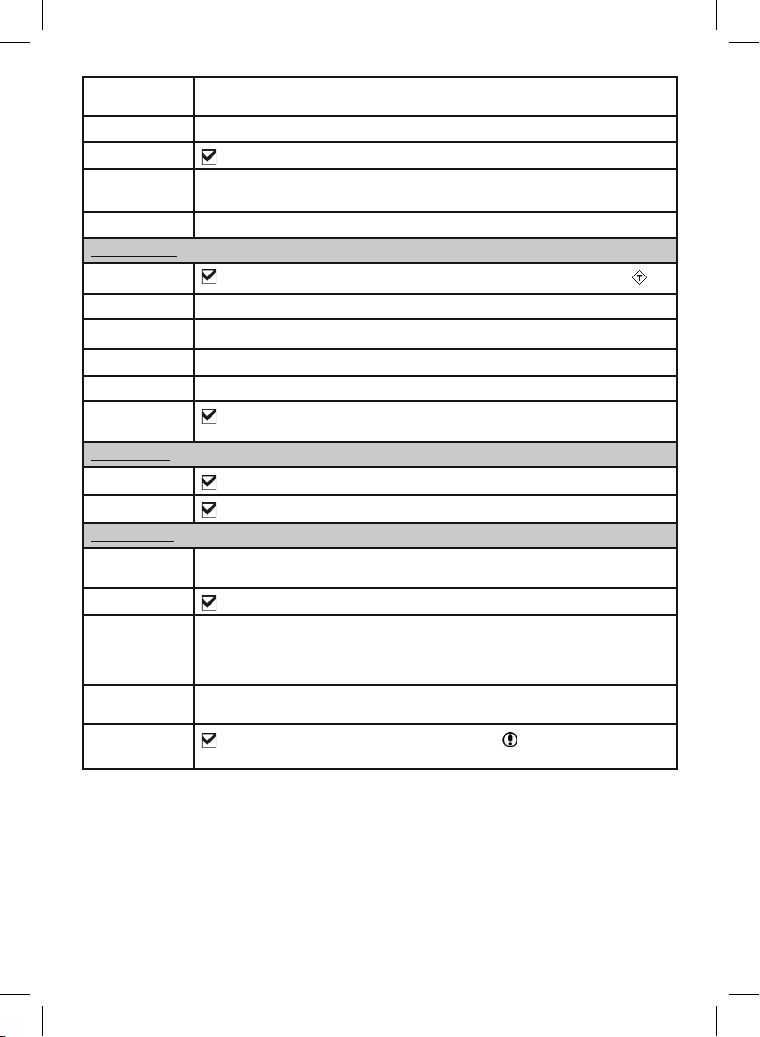
Projected course
The 657 can estimate the course after a given time, based on the current speed and heading (see
section 3-4). The options are 2 minutes, 10 minutes, 30 minutes, 1 hour, 2 hours or Off
CDI scale See Appendix C. T he options are 0. 05, 0.1, 0.2, 0.5, 1.0, 2.0, 4 .0 and 10.0 distance uni ts
Lat/lon grid
Displays a la titude and longit ude grid
Boundaries Displays boun daries around areas wh ere more detailed cha rt coverage is availab le:
Auto shows the ne xt four detail lev els; On show s all
Text/icon size Sele ct the size of char t text and icons
Water submenu
Water features
Displays marine sediment labels (for example, M shows areas of mud) and tide station icons
Bathymetrics Displays u nderwater depth co ntours between B ath & sndgs m in and max
Spot soundings Di splays depth soundi ngs between Bath & s ndgs mi n and max
Bath & sndgs min The minimum depth fo r Bathymetrics and Spot soundings
Bath & sndgs max The maxim um depth for Bathymetrics and Spot soundings
Tidal flow
Displays d ynamic tide flow s: arrows on a chart sho wing the present tide s tream and
orientation (requires a GPS fi x and an NT-MAX card)
Land submenu
Land features
Land elevation
Displays land features, for example regions, rivers, roads, railways, airports
Displays land contours, shaded like depths (requires an NT Max card)
Other submenu
Waypoints Displays waypoints: Hide all only displays w aypoints on any selec ted route; Selected
Names
displays way points with their d isplay option set to Icon o r I+N (Icon and Name) (se e section 5)
Displays p lace names
Lights Li ght House display opti ons: Off hides a ll light indicators (th e icon still shows); No s ectors hides
sector s; On shows sector s; Animated activ ates light animation.
Note: with light an imation enabled se ctors are not visibl e, animation only op erates in single
chart vi ew or in the top chart of c hart + chart
Nav-aids Displays s ignals (fog, radar, rad io stations) and bou ys. Int and US select the icon f ormat;
Attention areas
Smpl draws simpler icon s
Displays at tention area boundar ies and information i cons ; at tention areas are impor tant
areas, such as re stricted anch orages or shallow are as
Northstar Explorer 657 Installation and Operation Manual64
Page 65
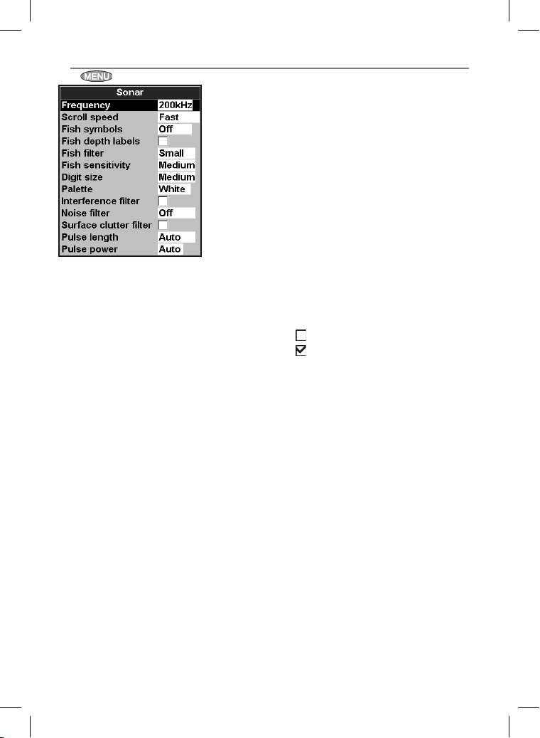
17-3 Setup > Sonar
Press twice, then select Sonar:
Frequ ency
There is a choice of: 200 kH z, 50 k Hz and
Mixed. For information about selecting a
suitable frequency for the water conditions. (see
section 8-3)
Scroll speed
Use this to set the scroll speed on the display.
There is a choice of: Ver y Fast, Fast,
Medium, Slow and Pause. The depth of the
water also af fects the speed of the display.
Faster scroll speeds combined with a slow
boat speed (typically between 2 and 6 knots)
shows the most fish detail. Medium or Slow
scroll speeds result in sonar information being
displayed over a longer period, but with less
detail (see Section 8-2).
Fish sy mbols
The 657 always displays echoes from fish (fish
arches, see section 8 -4). If fish symbols are on, a
symbol is displayed over the arch (see sec tion
8-4). The options are:
• Off: No fish symbol is displayed.
• Fun or Normal: A fish symbol is displayed.
• Fun + depth or Nor mal + depth: A
fish symbol is displayed and the depth shown
beside the fish symbol.
Fish f ilter
Use this to select the minimum fish size that will
be displayed as a fish symbol and to trigger the
Fish alarm. The options are: Small, Medium
and Large.
Fish sensitivity
Selects the minimum strength fish echo that will
be displayed as a fish symbol. Higher values will
display more fish symbols.
Digit size
Use this to remove or change the size of the
depth window on the sonar displays. There is a
choice of: Small, Medium and Large.
Pale tte
Use this to selec t a color palette. Each color
within the palette represents a different echo
strength, as shown on the sonar displays.
There is a choice of five color palettes: Black ,
Blue, White, Vivid and 8 color. The firs t
four pallet tes display more detail, and each color
covers a 1.5 dB signal range. The 8 color
palette displays less detail, and each color covers
a 3 dB signal range.
Interference filter
No filter, normal setting.
Filters the echo signal to remove spiky
interference such as engine noise or depth
sounders on nearby boats.
Noise filter
Averages the echo signal to remove rapid
changes. Select Meduim or High to give a
smoother bot tom trace–this may help to detect
a deeper bottom; however these settings may
also remove fish echoes. Select Of f for best
fishfinding.
Pulse leng th
This can be used to specif y the length of the
transmitted ultrasonic pulse. A shor t pulse length
improves the display detail but contains less
energy, therefore it does not penetrate as deeply
into the water as a longer pulse.
There is a choice of Auto, Short, Medium or
Long. The Auto setting is recommended.
Pulse power
This can be used to specif y the power output
of the transmitted ultrasonic pulse. Low power
output conserves the battery and produces a
clear display in shallow water.
There is a choice of Auto, Low, Medium or
High. The Auto setting is recommended.
65Northstar Explorer 657 Installation and Operation Manual
Page 66
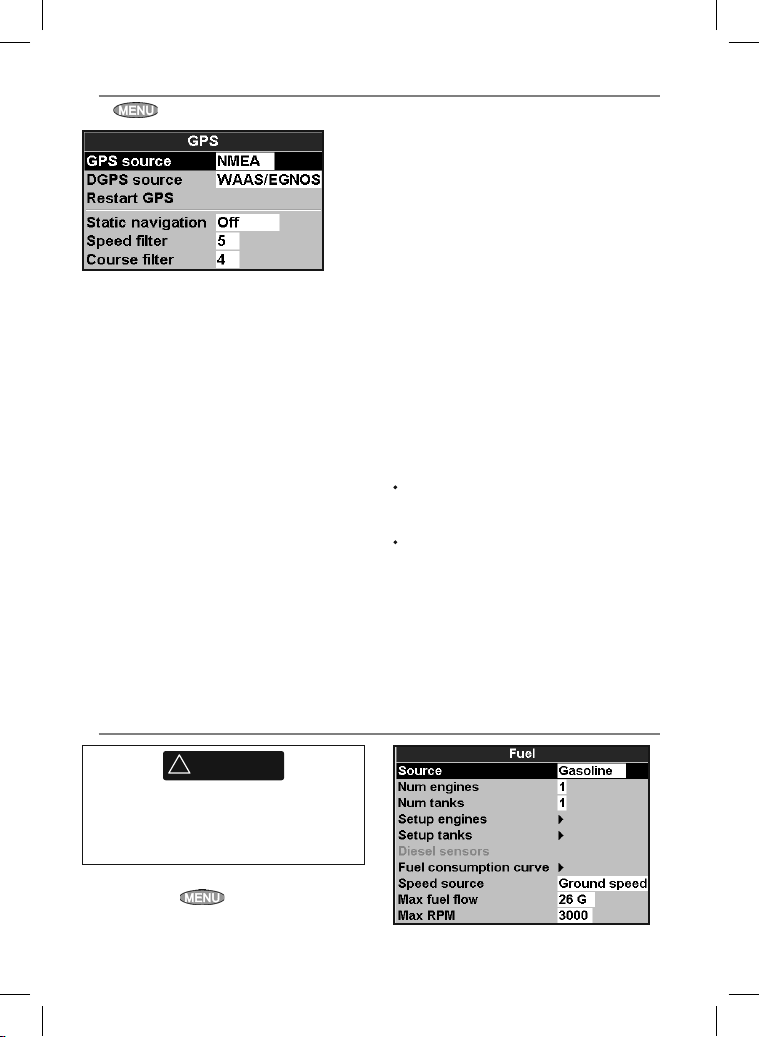
17-4 Setup > GPS
Press twice, then select GPS:
GPS Source
• NMEA: Use the external GPS antenna
supplied or an external GPS or DGPS source
connected via NMEA (see section 18-10).
• NavBus: Use an external GPS or DGPS source
connected via NavBus (see section 18-9).
DGPS Source
Enables or disables the satellite based DGPS
correction (see section 7). The options are
or WAAS/EGNOS. Do not enable WAAS/EGNOS
outside their coverage areas or the accurac y of
the position might be degraded.
WAAS covers all of the USA and most of Canada.
To use WAAS, the GPS antenna must have a clear
view of the sk y towards the equator. EGNOS will
cover most of Western Europe when it becomes
operational.
None
Restart GPS
Restar ts the internal GPS receiver for servicing
or troubleshooting. The GPS receiver takes up
to three minutes to restart. The satellite window
shows the status of the GPS receiver (see section
7). Restart the GPS if the receiver has not been
used for some time and is taking a long time to
get a GPS fix.
Static Navigation
When the boat stops or moves ver y slowly, the
calculated GPS speed and course become erratic.
Static navigation allows the erratic values to be
filtered:
• 0.01 to 99.9: If the boat speed is slower than
this, the speed is displayed as zero and the
course stays unchanged.
• 0 (Of f): The calculated speed and course are
always used.
Speed and Cou rse Filter
Waves and wind cause the boat speed and
course to fluctuate slightly. To give stable
readings, the 657 calculates these values by
taking several measurements and averaging
them.
A lower value averages measurements over
a shorter period of time. This gives the most
accurate value but has the most f luctuations.
A higher value averages measurements
over a longer period of time. T his gives the
most stable value but will ignore some [true]
sudden speed changes.
Set the Speed and Course filters to the lowest
values which give stable readings. The range of
each filter is 1 to 60 seconds or Of f (0).
17-5 Setup > Fuel
!
WARNING
Fuel consumption can change drastically
depending upon the boat loading and the
sea conditions. Always carry adequate fuel for
the journey, plus a reserve.
Fuel functions require optional fuel flow sensors to
be installed. Press
twice, then select Fuel:
Northstar Explorer 657 Installation and Operation Manual66
Page 67
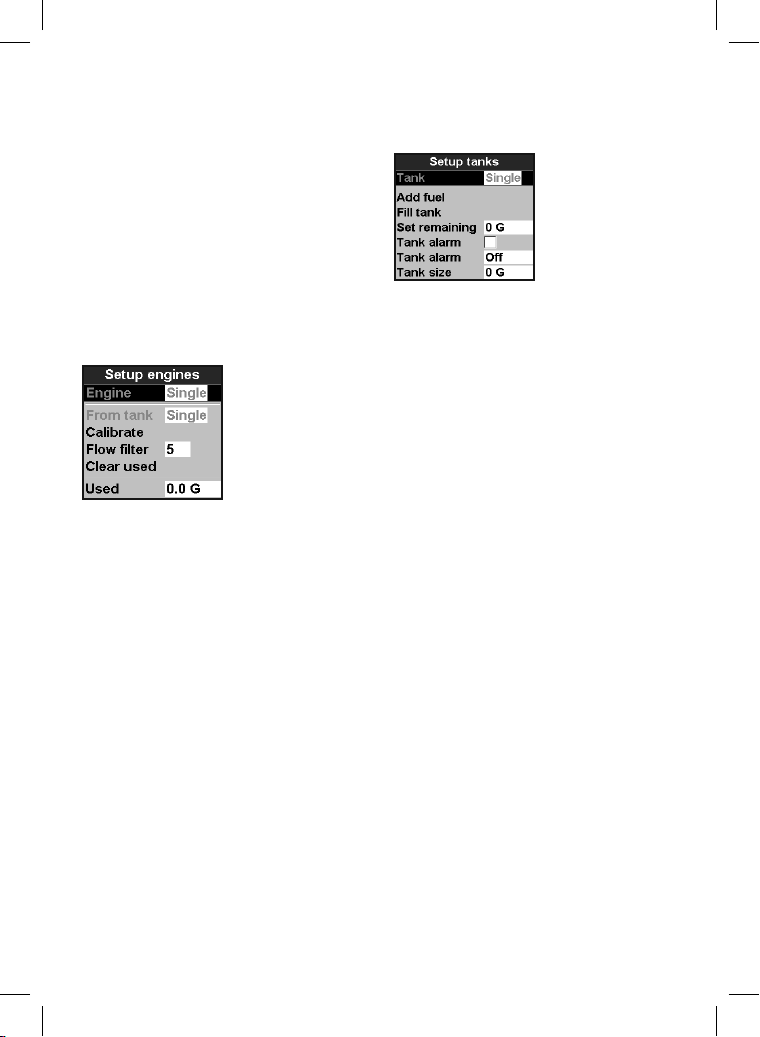
Source
Select the fuel flow sensors to use if the boat has
more than one set of fuel sensors. Normally select
Auto.
Num engines
Set the number of engines, or select 0 to disable
the fuel functions. If there are two engines they are
called port and starboard.
Num tanks
Set the number of fuel tanks. If there are two tanks
they are called port and starboard.
Setup engines
If the boat has more than one engine, select Engine
and select each engine in turn.
For the selected engine, you can enter:
From tank: The fuel tank the engine is connected to.
Flow filter: Most engines do not draw fuel from
the tank at a steady rate. To give a stable fuel flow
reading, the TRACKER calculates the flow by taking
several measurements and averaging them. Use the
Flow filter to set the period over which the fuel flow
is averaged.
The Flow filter can be set from 0 to 30 seconds. Use
the lowest value which gives a stable flow.Usually
a value of 5 to 10 seconds will give a satisfactory
result for two-stroke carburettor engines. Fuel
injected or four-stroke engines may require a larger
value.
This setting affects the Fuel flow and Fuel economy
reading on the Fuel window but it does not affect
the Fuel used reading.
Setup tanks
If the boat has more than one tank, select Tank and
select each tank in turn.
For the selected tank, you can enter:
Add fuel, Fill tank, Set remaining:
See section 12-3.
Tank alarm: See section 12-4.
Tank size: The tank capacity. Northstar
recommends measuring tank size by draining
the fuel tank, filling it to capacity and using the
fuel dispenser’s reading. Beware of air pockets,
especially in underfloor tanks.
Fuel consumption curve
See section 10-6.
Speed source
If both water speed and ground speed are available,
select which to use for fuel calculations (see section
10-5-1).
Max fuel flow
The maximum fuel flow from a fuel tank to be
displayed on an analog fuel flow gauge (see section 8)
67Northstar Explorer 657 Installation and Operation Manual
Page 68
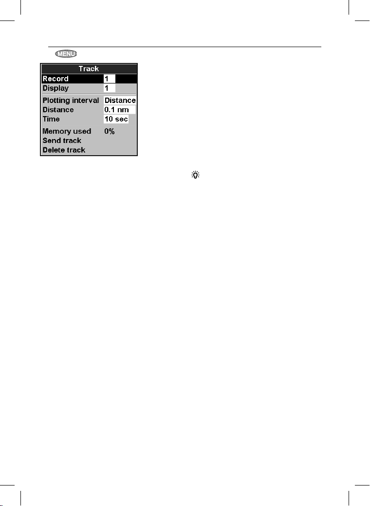
17-6 Setup > Track
Press twice, then select Track:
Tracking records and displays the boat’s course
on the chart (see section 3-5). Five different tracks
can be recorded: track 1 has up to 2000 points
and tracks 2, 3, 4 and 5 have up to 500 points
each.
Record
Off: The 657 stops recording a track.
1 to 5 (selec t a track number): The 657
starts recording the boat’s course into the
selected track.
Display
Off: No track is shown on the chart.
1 to 5 (selec t a track number): The
selected track is shown on the chart.
Plotti ng Interval
Select the plotting and recording interval. The
options are Dista nce or Tim e.
Distance
Select the distance plotting interval: 0.01, 0.05, 0.1,
0.5, 1.0, 2.0, 5.0 or 10.0 distance units.
Time
Select the time plotting interval: 1, 5, 10 or 30
seconds or 1 minute.
Memory used
The percentage of memor y used in the track
being recorded.
Tip: Use the user card window to check the
number of points recorded in each track
(see section 14).
Send track
This option is included for compatibilit y with
older units. For information, see your Northstar
dealer.
Delete track
The data in the track selected for Record (see
above) is deleted.
Northstar Explorer 657 Installation and Operation Manual68
Page 69
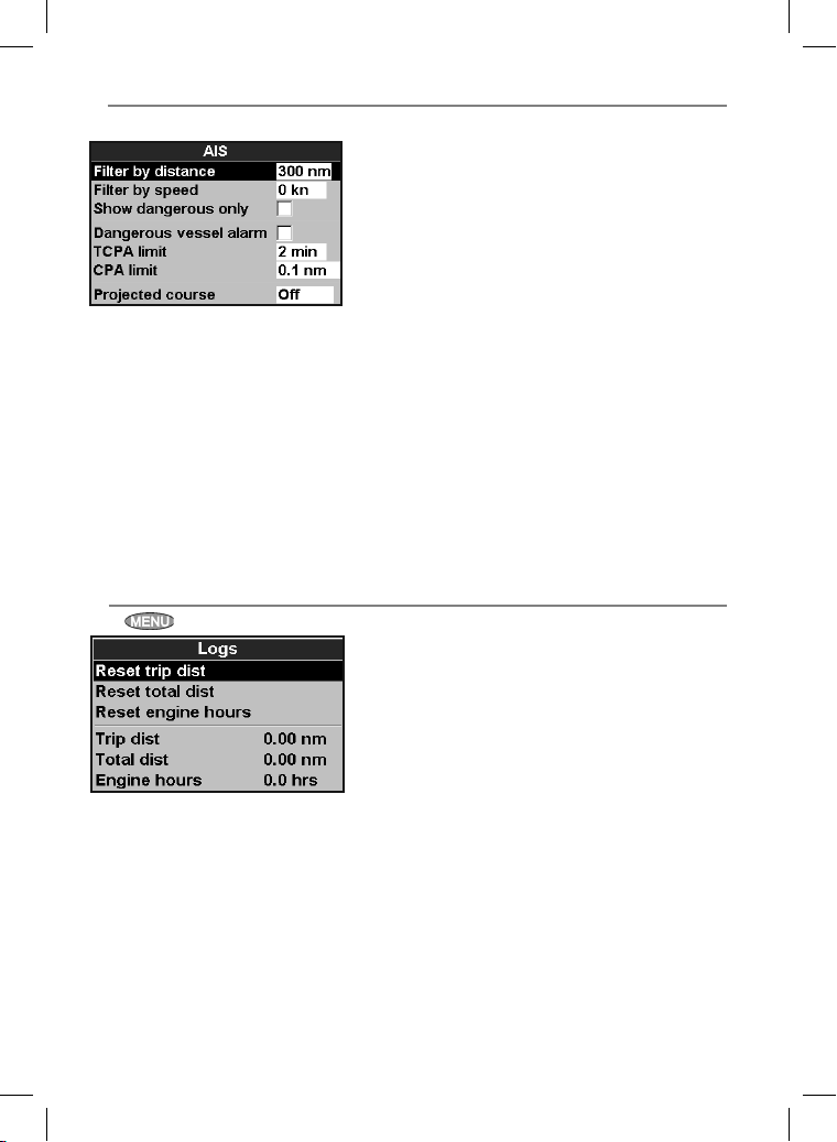
17-7 Setup > AIS
Note: This feature requires an AIS receiver.
There are multiple methods to filter AIS vessels
that are displayed onto the charts.
Filte r by dista nce
Vessels outside the radius selected from our
current position is filtered off the chart. Default
value is set to 300 nm allowing all vessels to be
displayed onto the chart within that distance.
Filter by spee d
Vessels with speed below value selected by user
is filtered off the charts. Default is set to 0 kn
allowing all vessels to be displayed onto the chart.
17-8 Setup > Logs
Press twice, then select Logs:
The values can be reset independently of each
other. These log values are saved when the unit
is turned of f.
Show Dange rous Only
Show vessels that have a TCPA/CPA below the
trigger values. This filter will override any other
filter option.
Dangerous Vessel Alarm
When enabled an alarm will activate when both
the TCPA and CPA is less than the trigger values.
Even when this set ting is disabled the dangerous
vessels will still be indicated on the char t.
TCPA Limit
Set the Time of Closest Point of Approach limit.
CPA Limit
Set the Closest Point of Approach limit.
Projecte d Course
Show the estimated course of all vessels based on
their current SOG and COG.
Reset trip di st
This resets the trip distance to zero.
Reset total d ist
This option resets the total distance to zero.
Reset engine hours
Use this option to reset the engine hours to
zero. This can be useful after an engine ser vice
or to count the engine hours between service
intervals.
69Northstar Explorer 657 Installation and Operation Manual
Page 70
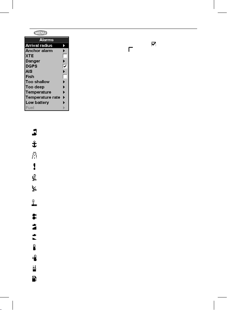
17-9 Setup > Alarms
Press twice, then select Alarms:
Symbol Alarm Alarm sounds when it is on and the:
Arrival radius
Anchor alarm Boat moves by more than the alarm trigger value
XTE Boat moves off course by more than the CDI scale (see section 14-2)
Danger Boat comes closer to a danger waypoint than the alarm trigger value
Loss of DGPS fi x 657 can not receive the DGPS signal (beacon, WAAS or EGNOS)
Loss of GPS fi x 657 can not receive the GPS signal (this alarm is always on
Loss of
AIS receiver
communication
Fish Echo matches the profi le of a fi sh
Boat is closer to the destination or to a waypoint than the alarm
trigger value
657 is no longer receiving communication from the AIS receiver
(Alarm is on when AIS is enabled)
All alarms except Loss of GPS fix can be
turned on (enabled) or off (disabled).
For all alarms select
select to turn the alarm off.
For most alarms there is a trigger value. The
alarm will sound each time the alarm value equals
the trigger value. For example, the
alarm will sound if the boat comes closer to a
danger waypoint than the trigger value and the
Anchor alarm will sound if the boat moves by
more than the trigger value.
Icons for alarms that are on can be displayed in
the data header (see sec tion 2-7-3). An alarm icon
is normally black and turns red when the alarm
sounds.
to turn the alarm on or
Danger
Too shallow Depth is less than the alarm trigger value
Too deep Depth is greater than the alarm trigger value
Temperature Temperature equals the alarm trigger value
Temperature rate Rate of change of temperature equals the alarm trigger value
Low battery Battery voltage is less than the alarm trigger value
Low fuel Fuel remaining equals the alarm trigger value
Northstar Explorer 657 Installation and Operation Manual70
Page 71
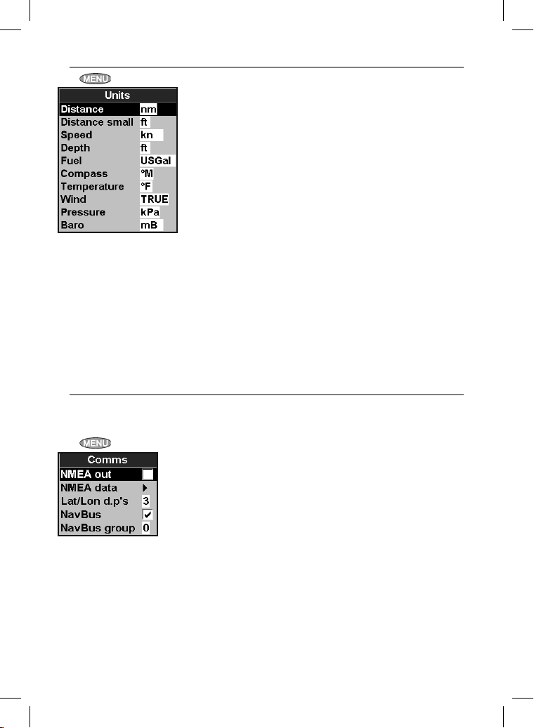
17-10 Setup > Units
Press twice, then select Units:
The default units are shown above.
Distance
nm (nautical miles), mi (miles) or km (kilometres)
Speed
kn (knots), mph (miles per hour) or kph
(kilometres per hour)
Depth
ft (feet), m (metres) or fa (fathoms)
17-11 Se tup > Comms
Use this feature when the 657 is connected to
other Northstar instruments through NavBus or
any compatible NMEA instrument.
Press twice, then select Comm s:
NMEA out
NMEA is generally used with third part y
instruments (see sec tion 18-10). Select this to
transmit NMEA sentences, for example to an
autopilot.
NMEA data
Use this to specify which NMEA sentences will be
transmitted (see sec tion 18-10 and Appendix A).
Height
ft (feet) or m (metres)
Fuel
Litres, USGal (US gallons) or ImpGal (Imperial
Gallons)
Compa ss
°T (True north) or °M (Magnetic north)
Tem per atu re
°F (Fahrenheit) or °C (Celsius)
Wind (optional)
Requires a wind instrument: True or App
(Apparent)
Note: that the units for wind speed are the speed
units.
Pressure
Requires Smar tCraf t™: kPa or psi
Baro (Baromet ric pressure)
Requires a Northstar VHF receiver with barometer
connected by NavBus: InHg or mB.
Lat/lon d ps
Select the number of decimal points used for
latitude and longitude transmit ted in NMEA
sentences.
NavBus
NavBus is the preferred method for connecting
the 657 to other Northstar instruments. Select this
if the instruments are connected using NavBus.
NavBus Group
Use this when a group of Northstar instruments
are connected together using NavBus, to specify
a group of instruments for backlighting, if
required. Then, if the backlight set ting on one
instrument in the group is adjusted, the other
instruments change automatically. Otherwise,
select 0. See section 18-9.
71Northstar Explorer 657 Installation and Operation Manual
Page 72
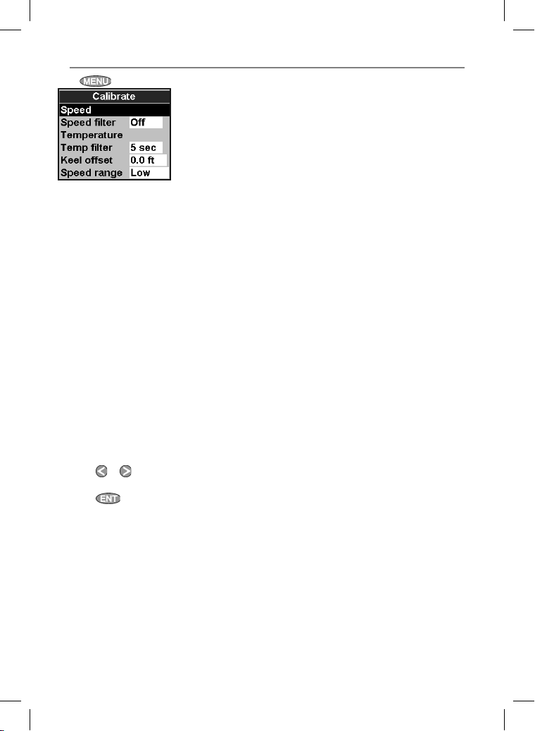
17-12 Setup > Calibrate
Press twice, then select Calibrate:
Speed
This calibrates the speed from a paddlewheel
sensor connected to the 657. Calibration may
be required because different hull shapes have
different flow characteristics. Obtain an accurate
measurement of the boat’s speed from a GPS
receiver; or by following another boat travelling
at a known speed; or by making a timed run over
a known distance.
Note: for accurate calibration:
• The speed from a GPS receiver should be
greater than 5 knots.
• The speed from another paddlewheel
transducer should be between 5 and 20
knots.
• Best results are achieved in calm conditions
where there is minimal current (best at high
or low tide).
Calibrating speed:
1 Travel at a constant, known speed.
2 In the Calibrate menu, selec t Speed.
3 Press
4 Press
or to change the displayed speed
to the true value.
.
Speed filter
Waves and wind cause the boat speed from the
paddlewheel transducer to fluc tuate slightly. To
give stable readings, the 657 calculates these
values by taking several measurements and
averaging them. Set the Speed filter to the lowest
value which gives stable readings. The range is 1
to 30 seconds or Off (0).
Tem per atu re
The factory set tings should be sufficiently
accurate for normal usage. To calibrate the
temperature readout, first measure the water
temperature with a thermometer known to be
accurate.
Use the cursor keys to display the temperature
readout box, then increase or decrease the
value to match the measured temperature. The
temperature can be set from 32° to 99.9°F (0° to
37.7°C) with a resolution of 0.1° unit.
To change the units between °F (Fahrenheit) or °C
(Celsius). (see section 17-10).
Temperature filter
Water turbulence and currents cause the water
temperature to f luctuate slightly. To give stable
readings, the 657 calculates these values by
taking several measurements and averaging
them. Set the Temperature filter to the lowest
value which gives stable readings. The range is 1
to 30 seconds or Off (0).
Northstar Explorer 657 Installation and Operation Manual72
Page 73
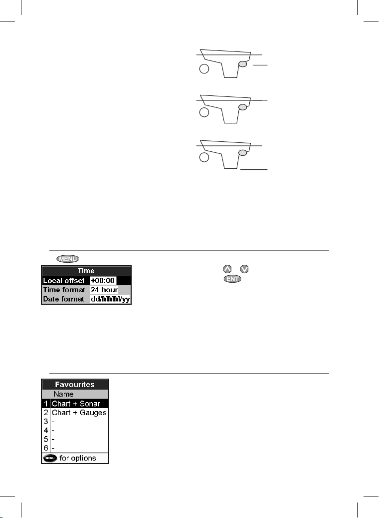
Keel Of fset
A depth transducer measures depths below
where the transducer is mounted on the boat,
usually the bot tom of the boat. The 657 calculates
the depths to display by adding the keel offset to
all measured depths.
A Have a zero keel offset to display depths
below the transducer.
B Enter a positive keel offset to increase the
displayed depth. For example to display the
total depths below the surface, enter the
depth of the transducer below the surface.
C Enter a negative keel offset to decrease the
displayed depth. For example, to display the
depths of clear water below the boat, enter
minus the depth of the deepest part of the
boat below the transducer.
Speed range
The maximum reading to display on an analog
boat speed gauge (see section 10). Choose a
range suitable for your boat.
17-13 Setup > Time
Press
twice, then select Time:
Local off set
The difference bet ween local time and UTC
(GMT). Change local of fset when daylight saving
time star ts and ends. The range is 0 to ± 13 hours,
in 30 minute steps.
A
B
C
Tra nsd uce r;
depths measured
below here
Depths measured
below here
Depths measured
below here
Fuel
See section 12-7, Calibration.
1 Select Local offset.
2 Press
or to change the offset, then
press .
Time format
The options are 24 hour or 12 hour.
Date format
The options are dd/MMM/yy, MMM/dd/yy,
dd/MM/yy or MM/dd/yy.
17-14 Setup > Favorites
See section 2-7-2
73Northstar Explorer 657 Installation and Operation Manual
Page 74
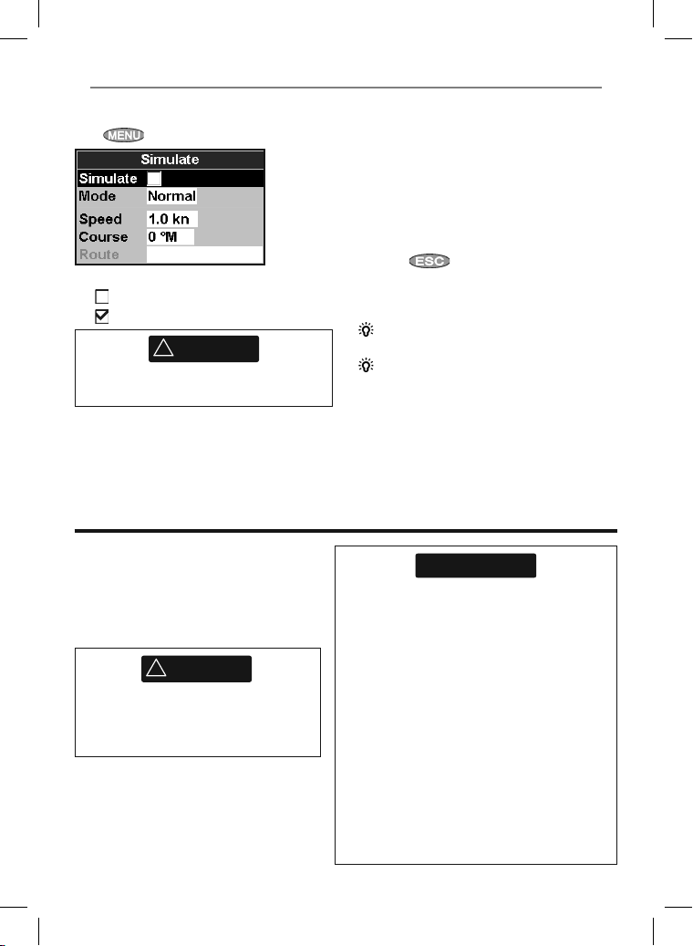
17-15 Setup > Simulate
Simulate mode is a way of becoming familiar with
the 657 (see sec tion 2-6).
Press
twice, then select Sim ulate:
Simulate
Turn simulate mode off
Turn simulate mode on
!
WARNING
Never have simulate mode on when the 657 is
navigating on the water.
Mode
There are two choices for Mode:
18 Installation
Correct installation is critical to the
performance of the unit. It is vital to read
the entire installation sec tion of this manual
and the documentation that comes with the
antenna and any other units before starting
installation.
!
WARNING
Ensure that any holes cut are in a safe
position and will not weaken the boat’s
structure. If in doubt, consult a qualified
boat builder.
1 Normal
Simulates the boat moving from the selected
start point at the given speed and heading. The
options required for Normal are:
Speed: The simulated boat speed to use.
Course: The simulated course over ground.
Note: To select the start point, go to the char t
window before starting the simulation. Then:
• To start the simulation from the boat position,
press
mode.
• To start the simulation from a different point,
move the cursor to that point on the chart.
Tip: To calculate a course, use the cursor (see
section 3-3).
Tip: As the boat moves, vary Course to
simulate the boat moving off course.
2 Demo
Simulates a boat moving along a route and
automatically displays dif ferent 657 functions.
The options required for Demo are:
Speed: The simulated boat speed to use.
Route: The route to follow.
to switch to center on boat
CAUTION
Do not mount any part where it can be used as a
hand hold, where it might be submerged or where
it will interfere with the operation, launching or
retrieving of the boat.
To help ensure proper operation, do not mount
any part or cable within 0.5 m (20”) of the plane of
a radar antenna or within 1 m (3 ft) of a compass
or source of electrical noise, such as engines,
fluorescent lights, and power inverters.
When fitting a cable, do not crush or strain the
cable. Secure the cable at regular intervals. Ensure
no connectors or exposed terminals are in wet
area.
If the cables supplied are too long, do not shorten
the cable; instead coil the cable. Most cables can
be extended with Northstar extension cables. Do
not fit more than one extension cable.
Northstar Explorer 657 Installation and Operation Manual74
Page 75
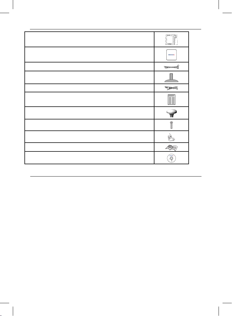
18-1 Installation: Wha t comes with the 657
657 display unit , with a holder for pl ug-in cards and bla nking cap for fue l connector.
Dust cover fo r display unit
Power cabl e
Mounting b racket (screws includ ed)
GPS connection cable
Warrant y registration c ard
Norths tar 124 GPS antenna
Flush mountin g kit
Dual freq uency transom s onar transducer (inc ludes cable kit an d screws)
Tra nsom Moun t Tran sduc er In sta llat ion M anua l
Full Instru ction Manual CD
18-2 Installation: Opti ons and Accessories
• Replacement paddle wheel
• C-MAP™ NT-MAX, NT+ or NT char t cards.
• C-MAP™ user cards (3 V) for storing data. (The
older 5 volt cards are not suppor ted)
• Northstar carr y bag.
• Northstar NavBus junction boxes simplify
wiring, par ticularly if several instruments are
connected. For more information, see the
NavBus Installation Manual.
Optional se nsors and instrument s
External alarms: Lights or sounders in the boat
to sound alarms through the boat (see section
18- 4).
GPS or DGPS antenna: For GPS navigation (see
section 18-5).
Sonar transducer: For depth sounding and fish
finding (see section 18-6).
Fuel sensors: For fuel functions. T he 657 can use
these optional fuel flow sensors, fitted to one or
two engines:
• Northstar petrol/gasoline sensors (see
section 18-7)
• SmartCraft™ fuel sensors (see section 18-10)
DSC VHF radio: Tracks other boats with GPS
receivers and DSC radios and displays barometric
pressure (see section 18-8).
SmartCraft™: With one or two SmartCraft™
capable Mercury petrol/gasoline engines, the 657
can display engine data and trim and can control
troll speed (see sec tion 18-10).
Other instruments: The 657 can receive data
from other instruments and send data to other
instrument s by NavBus or NME A (see sec tions
18-11 and 18-12).
Please consult your Northstar dealer for more
information.
75Northstar Explorer 657 Installation and Operation Manual
Page 76
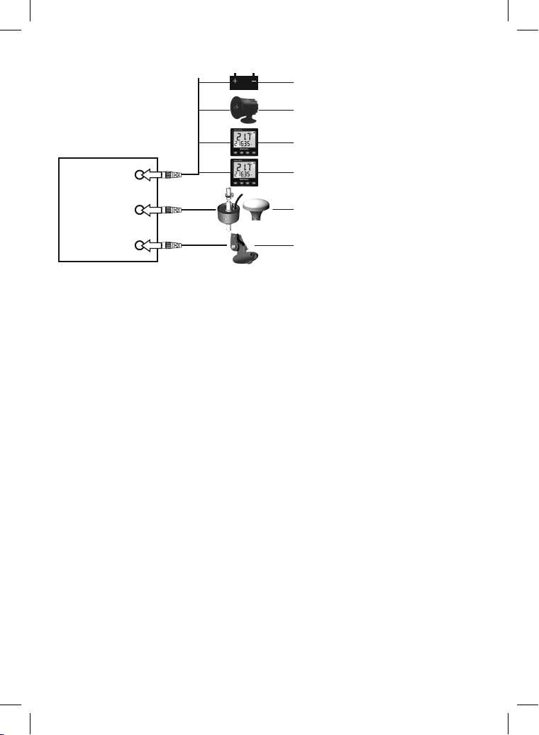
Conne ctions
Display unit
(18-3)
Black
Power (18-4)
External alarms (18-4)
NavBus instruments (18-9) and VHF
radio (18-8)
NMEA out to instruments (18-10)
Yellow
Blue
GPS antenna (18-5), Petrol/gasoline
sensors (18-7), NMEA in (18-10)
Sonar transducer (18-6)
Power/data cable
Pin Wire Function
1 Black Ground: - power in, NMEA ground. (The cable has two black wires which are
connected inside the cable and it does not matter which black wire you use)
2 Brown Not used
3 White NMEA out
4 Blue NavBus-
5 Red Power in, +10.5 V DC to +30.5 V DC
6 Orange NavBus+
7 Yellow Auto power in
8 Green External alarm out, 30 V DC 200 mA maximum.
Northstar Explorer 657 Installation and Operation Manual76
Page 77
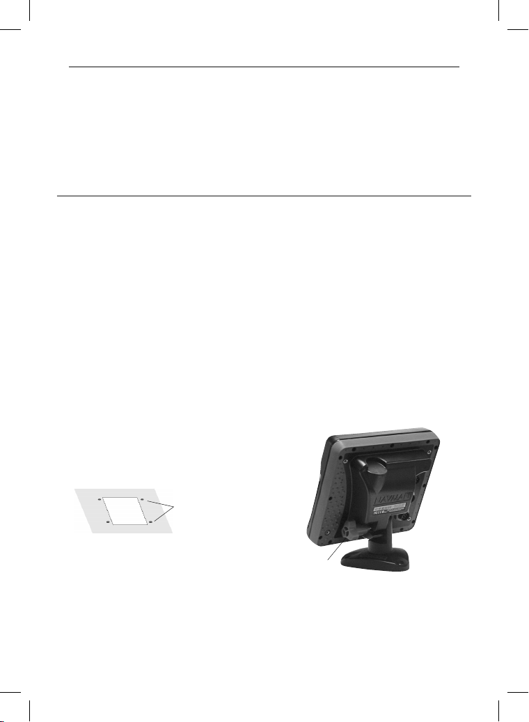
18-3 Installation: The d isplay unit
Select a position for the display unit:
• At least 4” (100 mm) away from the compass,
at least 12” (300 mm) away from any radio
transmitter and at least 4 f t (1.2 m) away from
any antenna.
• Easy to read and operate. If possible, mount
the display unit in front of the navigator or to
the right of the navigator because the LCD
display is more readable from these positions.
There are two mounting arrangements:
1 Flush Mounti ng
Requires a solid panel with access behind
for wiring and mounting screws. After f lush
mounting, the display unit cannot be tilted or
moved after installation to reduce any unwanted
glare or reflections. Carefully select the best
viewing position before installation. This would
generally be in a shaded area.
1 Cut a hole in the bulkhead for the display unit
using the flush mount template.
2 Drill four holes for the mounting studs using
the flush mount template.
3 Screw the four studs into the brass inserts in
the back of the display unit.
4 Sit the display unit in place and fit the
washers and nuts to the studs.
• Not exposed to the direct sun or water and
protected from physical damage during
rough sea passages.
• Easy to access the power source and
convenient to route the transducer cables.
2 Bracket Mount ing
Requires a panel for mounting the bracket. Ensure
that the panel is not likely to deform and is not
subject to excessive vibration. The bracket can
be tilted and rotated. The display unit can be
removed when it is not in use.
1 Hold the bracket in place and mark the screw
holes.
2 Drill the screw holes and screw the bracket in
place. Do not overtighten the screws or the
display unit might not rotate.
3 Hold the display unit in place on the
mounting bracket shaft. Hand tighten the
knob on the mounting bracket.
Knob
Mounting bracket
77Northstar Explorer 657 Installation and Operation Manual
Page 78
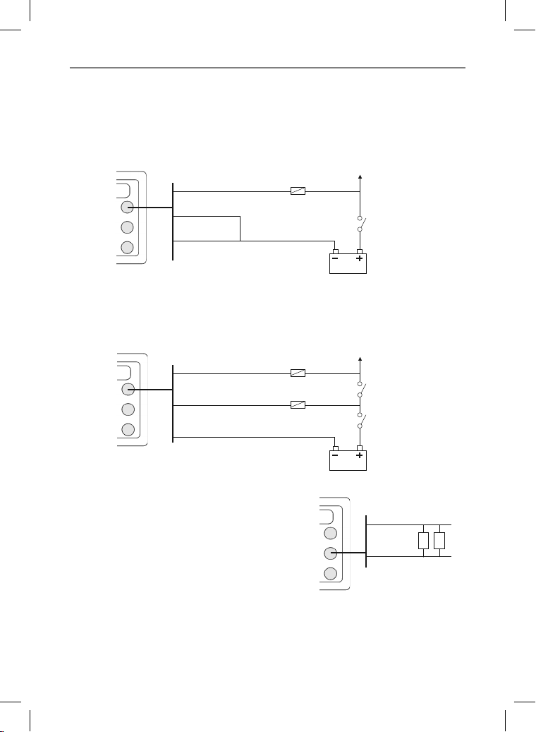
18-4 Installation: Power/data cable
The power/data cable has a black locking collar and flying leads.
1 Wire the 657 for auto power to have the 657 turn on with the boat’s ignition switch or to to record
engine hours or if the 657 must add up the total fuel used (for example if Northstar petrol/gasoline
fuel sensors are installed or if SmartCraft™ is installed without fuel tank level sensors). Otherwise wire
for basic power (for more information, see section 2-2).
Basic power
Power/data cable
Red
Black
Auto power
During setup, set up Auto pow er off (see sections 2-2 and 17-1)
Yellow
Black
Fuse 2A
Main switch
12/24 V DC
Power/data cable
Yellow
Black
2 Wire any external alarm beepers or lights. The
alarm output switches to ground to sound
the alarm. If the current is more than 200 mA,
fit a relay.
3 Connect the power/data cable to the black
display unit connector; turn the collar to lock
the connector.
Red
Black
Northstar Explorer 657 Installation and Operation Manual78
Fuses 2A
Black
Ignition
Ignition switch
Main switch
12/24 V DC
Power/data cable
Red
Green
External beepers or
lights
Page 79
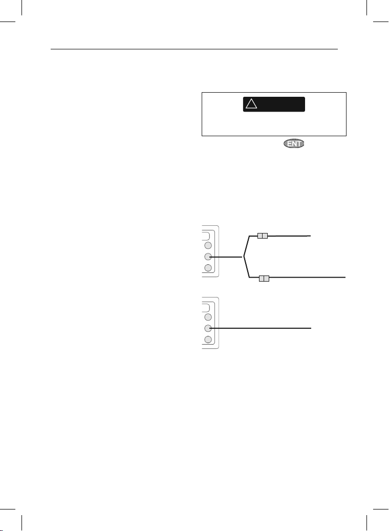
18-5 Installation: GPS a ntenna
Selecting an antenna
Fit one of these GPS antennas:
• Normally use the GPS antenna supplied.
• An optional differential beacon DGPS
antenna to give enhanced accuracy within
range of land based dif ferential beacons
in areas where WAAS or EGNOS are not
available. Such a DGPS antenna has both a
GPS receiver and a beacon receiver, and it
automatically applies the beacon correction
to the GPS position.
• A compatible GPS or DGPS instrument or
antenna connected by NavBus (see sec tion
18-9) or NMEA (see section 18-10). In this case,
the 657 does not need its own antenna.
Note:
• To configure the 657 for different antenna
options, see section 17-4.
For more information, contact your Northstar
dealer.
DGPS Source:
Enables or disables the satellite based DGPS
correction (see section 7). The options are
None or WAAS/EGNOS. Do not Enable
WAAS/EGNOS outside their coverage areas or the
accuracy of the position might be degraded.
WAAS covers all of the USA and most of Canada.
To use WAAS, the GPS antenna must have a clear
view of the sk y towards the equator. EGNOS will
cover most of Western Europe.
Restart GPS:
Restar ts the GPS receiver, satellite reception will
be lost until the receiver completes its restart and
acquires the satellites.
!
WARNING
MOB will not work if the Instrument does not
have a GPS fix.
Select restart GPS and press
Installing an antenna
If an external antenna is required, install the
antenna and fit the antenna cable back to the
display unit. Follow the instructions in the manual
supplied with the antenna. Fit an optional
Northstar extension cable if required.
If a SmartCraft™ system or Northstar petrol/
gasoline sensors are fit ted as well, fit a AIS cable:
Yel low
Otherwise:
Yellow
Yellow
GPS/fuel AIS cable
White
GPS antenna
GPS antenna
Other connections
During setup, configure the 657 for the chosen
antenna, see section 17-4.
79Northstar Explorer 657 Installation and Operation Manual
Page 80
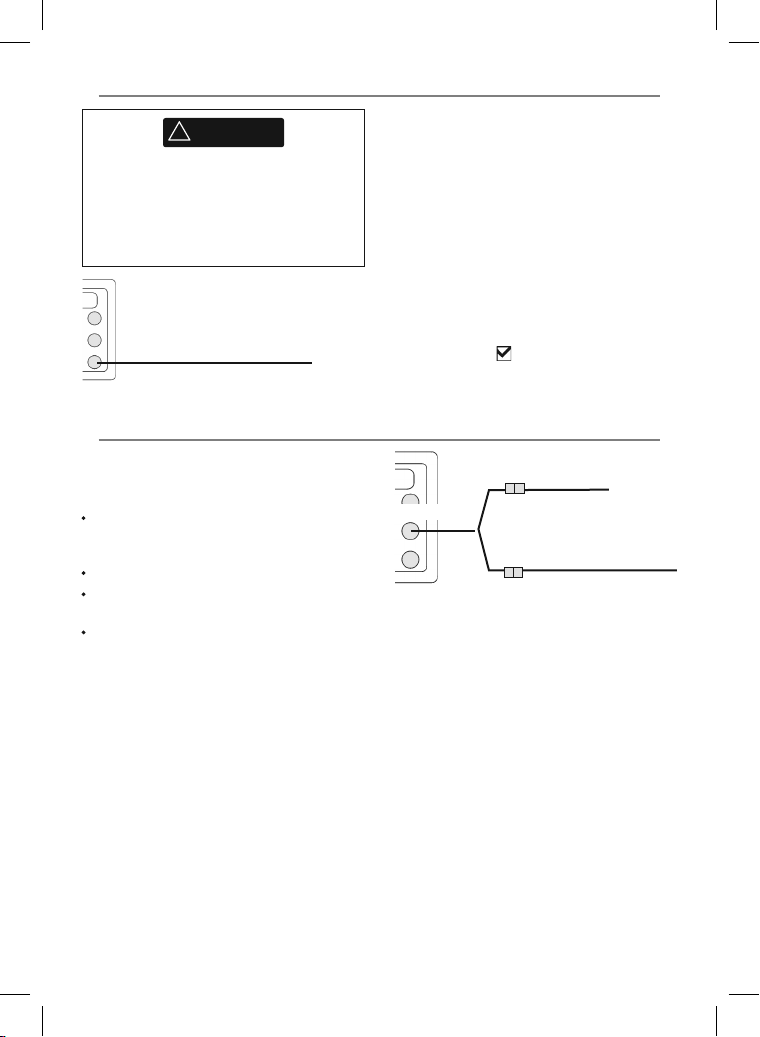
18-6 Installation: Sonar transducer
!
WARNING
Do not install plastic through hull transducers
in solid wooden hulls. Leakage through the
hull may result.
Do not install bronze transducers in metal
hulls. This will cause electrolytic corrosion that
may result in damage to the hull or transducer.
Blue
Sonar cable
18-7 Installation: Nor thstar petrol/gasol ine sensors
Fit the optional petrol/gasoline fuel kit following
the instructions supplied with the kit.
Note:
SmartCraft™ engines have fuel flow sensors,
therefore Nor thstar fuel sensors are not
required as well.
For dual engines, fit two kits.
Wire the 657 for auto power (see section
18- 4).
An optional GPS/fuel AIS cable is required.
Either:
• Fit the transom mount sonar transducer
supplied, following the instructions in the
Tra ns om Mo unt Tr ansducer Ins tall atio n
Manual supplied with the 657.
• For enhanced performance, fit an optional
through hull dual frequenc y sonar transducer
and through hull speed/temperature
transducer. Contact the nearest Northstar
dealer for more information.
Connect the transducer to the blue 657
connector; tighten the locking collar.
During setup
a set Sonar to
b set up the sonar options (see section 17-3)
Yellow
During setup:
a set up Auto power off (see sections 2-2 and
17-1)
b set the fuel data (see section 17-5)
(see section 17-1)
GPS antenna (optional)
Yellow
GPS/fuel AIS cable
White
Fuel sensor cable
Northstar Explorer 657 Installation and Operation Manual80
Page 81
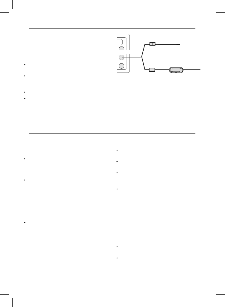
18-8 Installation: SmartCraft™
If the boat has one or two Smar tCraf t™ capable
Mercury petrol/gasoline engines, connec t the
657 to the SmartCraft™ engines with an optional
SmartCraft™ gateway. The display unit can display
engine data and trim and can control troll speed.
Note:
Fit a single gateway for single engines and a
dual gateway for dual engines.
SmartCraft™ engines have fuel flow sensors,
therefore Nor thstar fuel sensors are not
required as well.
An optional GPS/fuel splitter cable is required.
If the fuel tank does not have SmartCraf t™
level sensors, wire for auto power (see section
18- 4).
18-9 Installation: O ther NavBus instruments
NavBus is Northstar’s system for connecting
instruments together to interchange data
and share transducers. When instruments are
connected by NavBus:
If the units, alarms or calibration are changed
in one instrument, then the values will
automatically change in all other instruments
of the same type.
Each instrument can be assigned to a group
of instruments. If the backlight is changed in
an instrument in group 1, 2, 3 or 4 then the
backlight will automatically change in the
other instruments in the same group.
If the backlight is changed in an instrument
in group 0 then no other instruments are
affected.
If an alarm sounds, mute it by clearing the
alarm on any instrument which can display
that alarm.
GPS antenna (optional)
Yellow
Enter the SmartCraft™ setup data. For information
on installing, setting up and using SmartCraft™,
see the SmartCraft™ Gatewa ys Installation and
Operation Manual.
NavBus and the 657
The 657 can:
Display wind speed and direction from an
optional Northstar Wind instrument.
Receive and display depth from an optional
Northstar depth instrument.
Receive and display boat speed and water
temperature from a paddlewheel sensor on an
optional Speed instrument.
Receive data from an optional Northstar VHF
radio (with NavBus functionality). The 657 can
display:
Baro: barometric pressure
Baro history: barometer history
Weather: a predication, based on changes in
barometric pressure
Fish forecaster: a prediction based on
changes in barometric pressure
DSC/Buddy Track: (see section 16)
Receive data from an optional GPS or
GPS/DGPS source.
Send data to optional Northstar instruments,
for example to a repeater.
Yellow
GPS/fuel AIS cable
White
SmartCraft™ gateway
81Northstar Explorer 657 Installation and Operation Manual
Page 82
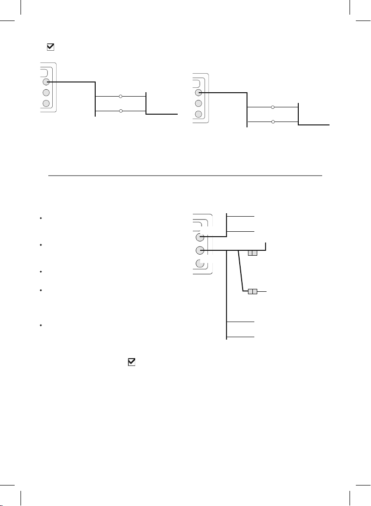
During setup for NavBus instruments, set NavBus
Black
Black
and assign the instrument a NavBus
to
group number (see section 17-11)
Black
Power/data cable
Orange
Blue
Other Navbus instrument
18-10 Installation : Other NMEA instrument s
NMEA is an industry standard for interconnecting
instruments. It is not as flexible or as easy to
install as NavBus.
The 657 can:
Receive and display wind speed and
direction from an optional compatible wind
instrument.
Receive and display depth, paddlewheel
boat speed and water temperature from an
optional compatible instrument.
Receive data from an optional compatible
GPS or GPS/DGPS source.
Send GPS position and other navigation
data to an autopilot or other instrument.
An autopilot requires APB, APA and VTG
sentences (see section 17-11).
Receive data from an optional AIS receiver.
For information on sending NMEA data to the 657,
see your Northstar dealer.
During setup to send NMEA data to other
instruments, set NMEA out to
the NMEA data to send (see section 17-11).
and specif y
18-9-1 Installation: Nor thstar VHF radio
Fit and set up the optional Nor thstar VHF
radio (with NavBus functionalit y) following the
instructions supplied with the radio.
Black
Power/data cable
Black
Yellow
Orange Blue
Blue Grey
Radio data cable
Power/data cable
White NMEA out
Black NMEA ground
GPS antenna
Yellow
GPS/fuel AIS cable
White
White NMEA in
(requires Special
Fuel Cable)
Red AIS data in
Black and
Shield Ground
Northstar Explorer 657 Installation and Operation Manual82
Page 83
18-11 Ins tallation: Setup and te st
Setup and test
1 Put a blanking cap on any unused connector
on the back of the display unit. Ensure all
connectors are plugged in and the display
unit is in place.
2 If the display unit is bracket mounted, adjust
tilt and rotation for best viewing and hand
tighten the knob.
3 Insert any required C-MAP chart card (see
section 1-3).
4 Turn the instrument on (see sec tion 2-2).
When the 657 is turned on for the first time, it
displays an installation menu:
i Select the language to use.
ii Change the data if necessary (see section
2-1)
iii When the setup data is correct, press
.
This data can be changed later
(see section 17).
5 Enter setup data to set up the 657 to your
requirements and to set up any optional
sensors or instruments (see section 17).
6 At the satellite display, check that it picks
up GPS satellites. Wait for the GPS receiver
to start up and the fix t ype to change from
‘Acquiring’ to ‘GPS fix’. This should take less
than two minutes (see section 7).
7 Go on a test run to check that the navigation
equipment works correctly, par ticularly when
a radio trans mitter or radar is used.
83Northstar Explorer 657 Installation and Operation Manual
Page 84
Appendix A - Specifications
GENERAL
Size: 5.9” H x 6.5” W x 2.6” D
(150mm H x 164mm W x 65mm D)
Display: 127 mm (5”) diagonal, TFT color, 480 x
640 pixels.
Backlight: Display and keys
Supply voltage
10.5 V DC to 30.5 V DC.
Supply current: at 13.8 V
350 mA min - no backlighting.
1A max - full backlighting. ]
External beeper or light output: Switched
to ground to sound alarm, 30 V DC, 200 mA
maximum.
Operating temperature
0°C to 50°C (32°F to 122°F)
ALARMS:
User set: Arrival radius, anchor, XTE, danger,
dangerous AIS vessels, too shallow, too deep,
fi sh, temperature, temperature rate, low
battery, low fuel (optional), loss of DGPS fix
Fixed: Loss of GPS fix
GPS NAVIGATION
Chart card: C-MAP™ NT-MAX, NT+ or NT
User card: 3.3 V C-MAP™
Waypoints: Up to 3000, with default or user-
defi ned alphanumeric names up to eight
characters.
Routes: 25 Routes, with up to 50 points each
Tracks: By time or distance, one track of 2000
points and four of 500 points.
Chart datums
121 Chart datums (see next page)
One user-defi ned map shift.
Chart scale: 0.05 to 4096 nm for chart (chart
dependent) down to 0.01 nm in plotter mode.
SONAR FISHFINDING
Depth range:
0.6 m (2 ft) to 1000 m (3300 ft )
Sonar output:
Power: Variable, up to 600 W RMS
Dual frequency: 50 khz and 200 kHz
Transom transducer cable length:
10 m (33 ft)
Depth acquisition time from startup:
Typically 2 seconds at 30 m (100 ft)
Temperature:
Range 0° to 37.7°C (32° to 99.9°F)
Resolution of 0.1° unit.
Speed (from paddlewheel transducer):
1 to 96.6 kph (57.5 mph, 50 kn).
FUEL COMPUTER
(Optional fuel sensor(s) required)
Engine types:
Outboard carburetted two stroke and EFI
petrol/gasoline engines: 50 to 300 hp.
Outboard four stroke petrol/gasoline engines:
90 to 300 hp.
Inboard petrol/gasoline engines: 70 to 400 hp.
Flow rate:
Minimum: 5 litres per hour (1.3 U.S. gallons per
hour).
Maximum: 130 litres per hour (34 U.S. gallons
per hour).
COMMUNICATIONS
NavBus
Connection to other Northstar instruments.
NMEA
NMEA 0183 ver 2 4800 baud
Inputs from compatible instruments:
BWR, DPT, GGA, GLL, GSA, GSV, HDG, HDM,
HDT, MTW, MWV, RMC, VHW, VTG and DBT
Outputs, for compatible instruments:
APA, APB, BWR, DBT, DPT, GGA, GLL, GSA, GSV,
RMB, RMC, MTW, VHW, VLW, VTG, XTE
STANDARDS COMPLIANCE
EMC:
USA: FCC Part 15 Class B.
Europe: (CE) EN64000-6-1 and EN64000-6-3
New Zealand and Australia: (C Tick) AS-NZS
3548.
Environment: IPx6/IPx7/CFR46 (with card holder
and connections in place)
Northstar Explorer 657 Installation and Operation Manual84
Page 85
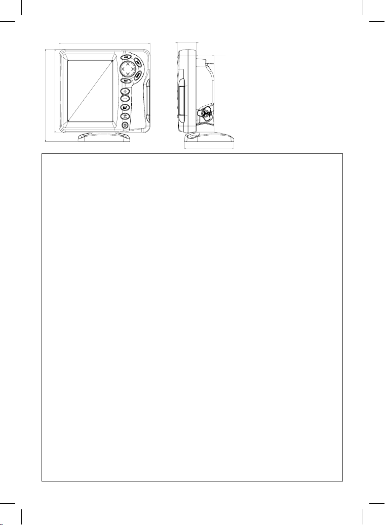
33.1
164.0
mm ( 6.5 ")
mm ( 1.3 ")
32.0
mm ( 1.3 ")
)"9.5 ( mm
)"5.6 ( mm
0.051
0.661
)" 5 ( mm 721
88.5
mm ( 3.5 ")
List of datums
Adindan Afgooye AIN EL ABD 1970
American Samoa 1962 Anna 1 Astro 1965 Antigua Island Astro 1943
ARC 1950 ARC 1960 Ascension Island 1958
Astro Beacon ‘E’ 1945 Astro DOS 71/4 Astro Station 1952
Astro Tern Island (Frig) 1961 Australian Geodetic 1966 Australian Geodetic 1984
Ayabelle Lighthouse Bellevue (IGN) Bermuda 1957
Bissau Bogota Observatory Bukit Rimpah
Camp Area Astro Campo Inchauspe 1969 Canton Astro 1966
Cape Cape Canaveral Carthage
Chatham Island Astro 1971 Chua Astro Co-ord. Sys.1937 Estonia
Corrego Alegre Dabola Deception Island
Djakarta (Batavia) DOS 1968 Easter Island 1967
European 1950 European 1979 Fort Thomas 1955
Gan 1970 Geodetic Datum 1949 Graciosa Base Sw 1948
Guam 1963 Gunung Segara GUX 1 Astro
Herat North Hermannskogel Hjorsey 1955
Hong Kong 1963 Hu-Tzu-Shan Indian
Indian 1954 Indian 1960 Indian 1975
Indonesian 1974 Ireland 1965 ISTS 061 Astro 1968
ISTS 073 Astro 1969 Johnston Island 1961 Kandawala
Kerguelen Island 1949 Kertau 1948 Kusaie Astro 1951
L. C. 5 Astro 1961 Leigon Liberia 1964
Luzon M’Poraloko Mahe 1971
Massawa Merchich Midway Astro 1961
Minna Montserrat Island Astro 1958 Nahrwan Masirah Is. Oman
Nahrwan United Arab Emirates Nahrwan Saudi Arabia Naparima, BWI
North American 1927 North American 1983 North Sahara 1959
Observatorio Meteorolog. 1939 Old Egyptian 1907 Old Hawaiian
Oman Ord. Survey Great Britain 1936 Pico de las Nieves
Pitcairn Astro 1967 Point 58 Pointe Noire 1948
Porto Santo 1936 Provis. South American 1956 Provis. South Chilean 1963
Puerto Rico Pulkovo 1942 Qatar National
Qornoq Reunion Rome 1940
S-42 (Pulkovo 1942) Santo (DOS) 1965 Sao Braz
Sapper Hill 1943 Schwarzeck Selvagem Grande 1938
Sierra Leone 1960 S-JTSK South American 1969
South Asia Tananarive Observatory 1925 Timbalai 1948
Tokyo Tristan Astro 1968 Viti Levu 1916
Voirol 1874 Voirol 1960 Wake Island Astro 1952
Wake-Eniwetok 1960 WGS 84 Yacare
Zanderij
85Northstar Explorer 657 Installation and Operation Manual
Page 86

Appendix B - Troubleshooting
This troubleshooting guide is written with
the assumption that the user has read and
understood the relevant sections in this manual.
It is possible in many cases to solve difficulties
without having to send the display unit back to
the manufacturer for repair. Please follow this
troubleshooting section before contacting the
nearest Nor thstar dealer.
There are no user serviceable parts. Specialized
methods and testing equipment are required
to ensure that the display unit is reassembled
correctly and is waterproof. Users who service the
product themselves will void the warrant y.
B-1 General problems
1-1 The 657 won’t turn on:
a The 657 is designed to operate on a 12/24
volt batter y system, where the voltage may
vary from 10.5 to 30.5 volts. If an excessive
voltage is supplied, a fuse will be tripped,
turning the display unit off. Check the fuse.
b Check that the power cable connector at the
back of the display unit is securely plugged
in and the collar is locked in place. The collar
must be secure for watertight connection.
c Measure the battery voltage while the battery
is under load - turn on some lights, radio or
other electrical equipment connected to the
battery. If the voltage is less than 10 volts:
- the batter y terminals or wiring on the
terminals may be corroded.
- the battery may not be charging
correctly or may need replacing.
d Inspect the power cable from end to end for
damage such as cuts, breaks, squashed or
trapped sections.
e Check power wiring (see section 18-4).
f Check for corrosion on the power cable
connector and clean or replace if required.
g Check fuses that are placed in line with the
power cable. A fuse can be blown despite
appearing to be good or the fuse may be
corroded. Test the fuse or replace it with a
fuse known to be good.
Repairs to the product may only be carried out
by a service center approved by Northstar. If the
product must be sent into a service center for
repair, it is essential to send in the transducer(s) at
the same time.
More information can be found on our website:
www.northstarnav.com.
1-2 The 657 won’t turn off:
The 657 may have been wired for Auto
power. In this case, the 657 cannot be turned
off while the ignition power is on (see section
2-2).
1-3 If the 657 beeps when turned on but
nothing is displayed:
The 657 may be operating, but the backlight
settings may have been set too low (see
section 2-3).
1-4 The wrong language is displayed:
See section 17-1.
Northstar Explorer 657 Installation and Operation Manual86
Page 87

B-2 GPS navigation proble ms
2-1 No GPS fix or long time to get f ix at
startup:
a May occur occasionally if the antenna does
not have a clear view of the sky. The satellite
positions are constantly changing.
b Antenna cable not connected to display unit.
2-2 657 GPS posi tion differ ent from true
position by more t han 10 m (33 ft):
a 657 in simulate mode. Turn simulate mode off
(see sec tion 17-15).
b The normal error in GPS position will exceed
10 m (33 ft) for about 5% of the time.
c Under special circumstances the US
Department of Defence may introduce a
deliberate and changing error in the GPS
positions of up to 300 m (1000 ft).
2-3 657 position different f rom same
position on loc al charts:
a 657 in simulate mode. Turn simulate mode off
(see sec tion 17-15).
b Incorrect char t datum. Select the correct
chart datum (see section 17-2).
c Map shif t has been applied wrongly. Clear
map shift, then reapply if necessar y (see
section 17-2).
2-4 Can not see b oat on chart:
Press to switch to center on boat
mode (see section 3-2-1).
2-5 The time or date on satellite window is
wrong or off:
a No GPS fix.
b In simulate mode. Turn simulate mode of f
(see sec tion 17-15).
c Local time offset is wrong (see section 17-13).
The Local Time Offset must be changed
when daylight saving time starts or ends.
2-6 Autopilot not res ponding to 657; no
NMEA output:
a NMEA output disabled or the required NMEA
sentences are not turned on. Check NMEA
settings (see section 17-10).
b Check that the instrument is connected
correctly.
2-7 No DGPS fix or loss o f DGPS fix:
a To receive a DGPS fix, WAAS/EGNOS must be
enabled or an optional DGPS antenna fit ted
(see section 7).
b With WAAS/EGNOS: Boat out of coverage
area (see sec tion 7).
c With WAAS: GPS antenna does not have a
clear view of the horizon towards the equator.
b With beacon DGPS: boat out of range of a
DGPS beacon.
B-3 Fuel consumption p roblems
3-1 Fuel used or remaining seem inaccurate:
a 657 is not wired for auto power (see section
18- 4).
b In rough seas, fuel may surge back and forth
through the fuel transducer, resulting in
incorrect readings. Try installing a one-way
valve between the fuel transducer and the
fuel tank.
c The Set remaining fuel value must be
reset after every refuelling (see section 12-1).
d The fuel tank may not refill to the same
capacity each time due to air pockets.
This is particularly noticable with underfloor
tanks.
e Fuel transducers wear out over time and
should be replaced after every 500 0 litres of
fuel.
3-2 Flow indicates no fuel or low fuel:
a Check that the number of engines is set to 1
(see sec tion 17-5).
b Check that the fuel cable connectors are
securely plugged in and the collar is locked
in place. The collar must be locked in place to
give a watertight connec tion.
87Northstar Explorer 657 Installation and Operation Manual
Page 88

c A fuel transducer may be clogged. If so,
remove the transducer from the fuel line
and gently blow through it in the opposite
direction to the fuel f low.
A fuel filter between the fuel transducer and
the fuel tank must be installed as per the fuel
installation guide. Failure to do so will void
the warrant y.
d Inspect the fuel cable from end to end for
damage such as cuts, breaks, trapped or
squashed sections.
e Check that the fuel filter is clean.
3-3 A twin engine installation shows only one
flow rate:
a Check that the number of engines is set to 2
(see sec tion 17-5).
B-4 Sonar fis hfinding problems
4-1 The 657 operates erratically:
a Check that the transducer does not have
debris (e.g. weed, plastic bag) caught
around it.
b The transducer may have been damaged
during launching, running aground or
while under way with debris etc. If the
transducer has been impacted, it may have
been kicked up on the bracket. If it is not
physically damaged, reset the transducer
back to its original position. (See the Tr ans om
Transducer Installation Guide.)
c When the transducer is less that 2 ft (0.6 m)
from the bot tom, the depth readings may
become inconsistent and erratic.
d Manual Gain may be set too low, which may
cause weak bottom echo or no fish signals. If in
Manual Gain, tr y increasing the Gain.
e Ensure the back of the bottom sur face of the
transducer is slightly lower than the front and
the front is as deep in the water as possible
in order to minimize the generation of
bubbles through cavitation. (See the Tran so m
Transducers Installa tion Guide)
f Check the transducer and power cable
connectors at the back of the display unit
3-4 Erratic Fuel Flow readings:
a The fuel flow transducer may have been
mounted too close to the fuel pump or may
be subject to excessive vibration. Refer to the
installation instructions supplied with the fuel
transducer.
b Check for leaks in the fuel line or in the fuel
pickup in the tank.
c The Flow filter value is not suitable for
the engine. Check that the value is not set
to zero, then try increasing the value until a
steady flow rate is shown (see section 17-5).
3-5 There is no reading for fuel economy:
a The boat must be travelling through the
water to generate an Economy reading.
b Check that the paddlewheel on the
transducer is spinning freely and that the two
magnets in the paddlewheel are still in place.
are securely plugged in and the collars are
locked in place. The collars must be secure for
watertight connection.
g Inspect the power cable from end to end for
damage such as cuts, breaks, squashed or
trapped sections.
h Ensure there is not another fishfinder or
depth sounder turned on, which may
interfere with this 657.
i Electrical noise from the boat’s engine or
an accessor y may be interfering with the
transducer(s) and/or the 657. This may cause
the 657 to automatically decrease the Gain
unless using Manual Gain.
The 657 thus eliminates weaker signals such
as fish or even the bottom from the display.
This may be checked by switching off other
instruments, accessories (e.g. bilge pump)
and the motor until the offending device
is located. To stop problems from electrical
noise, try:
- re -routing the power and transducer
cable(s) away from the boat’s other
electrical wiring.
- routing the display unit’s power cable
directly to the batter y with an in-line fuse.
Northstar Explorer 657 Installation and Operation Manual88
Page 89
4-2 Bottom is not displayed:
a The 657 may have Manual Range selected
and the depth may be outside the range
value selected. Either change the 657 to
Auto Range or select another depth range
(see section 8-5).
b The depth may be outside the 657’s range.
While in Auto Range, the display unit will
display “--.-” to indicate that there is no bottom
detected. A display of the bottom should
reappear when in shallower water.
4-3 The bottom is displayed too far up
the screen:
The 657 may have Manual Range selected
and the selected Range value is too high for
the depth. Either change the 657 to Auto
Range or select another depth range (see
section 8-5)
4-4 Bottom echo disappears or erratic digital
reading while the boat is moving:
a Ensure the back of the bottom surface of
the transducer is slightly lower than the
front and the front is as deep in the water as
possible in order to minimise the generation
of bubbles through cavitation. (See the
Transom Transducers Installat ion Guide, for
more information.)
b The transducer may be in turbulent water.
Air bubbles in the water disrupt the echoes
returned, interfering with the 657’s ability to
find the bot tom or other targets. This often
happens when the boat is reversed. The
transducer must be mounted in a smooth
flow of water in order for the 657 to work at
all boat speeds.
c Electrical noise from the boat’s motor can
interfere with the 657. Try some suppression
spark plugs.
4-5 There is a double bottom trace displayed:
a The boat may be in an area that generates
shadows (see section 8-2).
b In shallow water, the echoes may bounce.
Reduce the gain setting (see sec tion 8- 6)
and/or reduce the sonar pulse power (see
section 17-3).
c Decrease the Range.
89Northstar Explorer 657 Installation and Operation Manual
Page 90
Appendix C - Glossary and navigation data
Glossary
Attenti on Area - An important area on a chart,
such as a restric ted anchorage or a shallow area
(see section 17-2).
AIS - Automatic Identification System. A System
where vessel information (location, course, speed,
etc.) is broadcast by VHF radio, for use by other
vessels in navigation and collision avoidance.
Bathymetric line - A depth contour line on
the chart.
Chart card - A plug-in card that stores chart data
for a region (see section 1-3).
C-MAP™ chart card - See Chart card.
C-MAP™ user ca rd - See User card.
CPA - Closest Point of Approach. The closest
distance two vessels will come to each other
based on their current course and speed.
Cursor - A
3-2).
DGPS - Differential Global Positioning System. A
navigation tool based on GPS with some errors
corrected (see section 7).
DSC - Digital Selective Calling. A feature of
marine radios enabling communication between
specific vessels, as well as distress alerts.
Goto - A simple way of navigating straight to a
waypoint or to the cursor position (see section
3-1).
GPS - Global Positioning System. A satellitebased navigation tool (see section 7).
Leg - The straight segments of a route between
waypoints. A route with four waypoints has three
legs.
symbol on the display (see section
MMSI - Maritime Mobile Service Identity. Unique
identification number for a vessel, for use in
Digital Selective Calling.
MOB - Man overboard.
MOB function - Starts navigating back to the
place where someone fell overboard (see section
2-4).
NavBus - A way of connecting Northstar
instruments together to share data (see sec tion
18- 9).
NMEA - National Marine Electronics Association.
NMEA 0183 - A standard for interfacing marine
electronic devices (see section 18-10).
Route: Two or more waypoint s linked in
sequence to form a course for the boat (see
section 6).
SmartCraft - A feature of Mercury Marine
engines for monitoring engine performance.
TCPA - Time to Closest Point of Approach.
Time until the closest point of approach for two
vessels.
User card - A plug-in card that stores waypoints,
routes and tracks (see section 1-2).
UTC - Universal Time Coordinated or Coordinated
Universal Time, which is a standard world time,
formerly called Greenwich Mean Time (GMT).
VHF - Very High Frequency. The frequency range
used by marine radios.
Waypoint - A position that you can set on the
657 chart, for example a fishing spot or a point on
a route (see section 5).
Northstar Explorer 657 Installation and Operation Manual90
Page 91
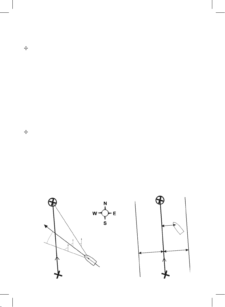
Navigation data
The boat is sailing from the start to the destination and has moved off the plotted course from the start
to the destination.
BRG Bearing to Destination: Bearing to the destination from the boat.
BRG Bearing to cursor: Bearing to cursor from boat (cursor mode, see section 3-2-1 [note the -1 added
there])
CDI Course Deviation Indicator: When the boat is navigating to a point, the chart and highway
windows show a parallel line on either side of the plotted course. These two lines are called the
Course Deviation Indicator (CDI) lines. The distance from the plotted course to a CDI line is the
CDI scale.
Set the CDI scale (see section 17-2) to the maximum distance that the boat should deviate from
the plotted course. The chart and highway windows show the CDI lines, which are like a highway
over the water where the boat will move. The windows show how far the boat has deviated from
the plotted course and if the boat is approaching a CDI line. If the XTE alarm is enabled (see
section 17-9) an alarm will sound if the boat reaches a CDI line.
COG Course Over Ground: Direction in which the boat is moving over the ground.
CTS Course To Steer: Optimum course to steer to return to the plotted course.
DTG Distance To Go: Distance from the boat to the destination.
ETA Expected Time of Arrival: At the destination, assuming that SOG and COG remain constant.
DST Distance from boat to cursor (cursor mode, see section 3-2)
SOG Speed Over Ground: Current boat speed over the ground. This is not necessarily the same as
the boat speed through the water nor the speed at which it is approaching the destination.
STR Steering: The diff erence between COG and CTS.
TTG Time To Go: The estimated time to reach the destination.
XTE Cross Track Error: The distance from the boat to the nearest point of the plotted course. XTE
may have a letter: R means steer to the right to return to the plotted course, L means steer to
the left.
VMG Velocity Made Good: The speed at which the boat is approaching the destination.
Destination
SOG (speed)
STR
Plotted
course
Start
DTG (distance)
VMG (speed)
BRG
COG
CTS
Boat position
Destination
Plotted
course
ne
I li
CD
CDI scale
(distance)
Start
XTE
(distance)
Boat
position
CDI scale
(distance)
ne
I li
CD
91Northstar Explorer 657 Installation and Operation Manual
Page 92
".&3*$"4
4VECVSZ3PBE
"DUPO."64"
1I
1I
'BY
TBMFT!COUNBSJOFDPN
&6301&
6OJU0DFBO2VBZ
#FMWJEFSF3E4PVUIBNQUPO
402:&/(-"/%
1I
'BY
OPSUITUBSVL!OPSUITUBSOBWDPN
"6453"-*"
10#PY
(MBEFTWJMMF/48
"6453"-*"
1I
'BY
OPSUITUBSBVT!OPSUITUBSOBWDPN
www.northstarnav.com
/&8;&"-"/%
10#PY
/FXUPO"VDLMBOE
"VDLMBOE/&8;&"-"/%
1I
'BY
OPSUITUBSO[!OPSUITUBSOBWDPN
Made in New Zealand
MN000651A-G
 Loading...