


1
User Manual
User Manual

User Manual
NOTICE
USING YOUR NAVIGATOR for the first time
1. Charge completely
2. Install into your vehicle
3. Initialize software as described in the manual
4. Make sure that the car is outside the garage and it is not covered by anything (treed,
bridges, etc)
5. Normally it takes a bit longer to receive the GPS signal the first time you turn on the unit.
Your device has to locate 3 satellites to function. This time to find the satellites is
significantly shorter after the first time you use the device. If you move your unit over
300km without it being used, it may need a little more time to locate the satellites again.
Introduction
This manual is a complete instruction for the device. Please read this manual
carefully before using.
Contents:
Safety and Regulatory Information
1. Getting Started………………………………………………………………….………………….……7
1.1 Unpacking ……………………………………………………….………………………….……7
1.2 Over View…………………………………………………………........................................7
1.3 Using Your Device in a Vehicle…………………………….…………………………………..8
1.3.1 Using the Car bracket……………………………………………….……………………………8
1.3.2 Connecting the Car Charger………………………………………….………………………..8
1.3.3 Charging the Battery………………………………………………………………………………9
1.3.4 Assembly……………………………………………………………………………………………..9
1.4 Starting up……………….………………………………………………………………………….11
1.5 Power saving……………………………………………………………………………………….11
2. Main Menu Selection………………………………………………………………………………..12
2.1 Navigation…………………………………………………………………………………………..12
2.2 Video………………………………………………………………………………………………….12
2.3 Photo………………………………………………………………………………………………...13
2.4 E-book……………………………………………………………………………………………….15
2.5 System……………………………………………………………………………………………....15
3. FREQUENTLY ASKED QUESTIONS…………………………………………………………….19
3.1 I can't find an address………………………………………………………………………..…20
3.2 There is a failure in the map / POIs are missing……………................................20
3.3 Voice instructions are unclear in a specific situation…………………………………..20
3.4 I have problems to get a GPS fix……………………………………………………………..20
3.5 Where can I get technical support? ……………………........................................20
3.6 Where can I get software updates? ……………………….....................................20
3.7 Where can I get additional maps and guides? ………………………......................20
2

User Manual
3.8 How to Install MSActiveSync (For Windows 2000 and XP only)…………………………..20
3.9 How to install Windows Mobile Device Center (For Vista users only)….………….21
3.10 How to download the files from the website and put in my SD Card? ……………23
3.11 What Kind of Formats Does The Device Support? …………………......................23
4. Connecting to Your PC………………………………………………………………………….…23
5. Troubleshooting and Maintenance………………………………………………………….24
5.1 Resetting Your System…………………………………….……………………………………24
5.2 Troubleshooting…………………………………………………………………………………..24
5.2.1 Power Problems………………………………………………………………………………....24
5.2.2 Screen Problems…………………………………………………………………………………24
5.2.3 Connection Problems ………………………………………………………………………….24
5.2.4 GPS Problems…………………………………………………………………………………….24
5.2.5 Voice too soft Or No Voice………………………………………………….…………………25
5.2.6 Why can’t use my download files (Option)……………………………..…………………25
5.3 Maintaining Your Device…..……………………………………………………………………25
6. Battery, Charger and Safety Precaution…………………………..........................25
6.1 About Charging…………………………………………………………………………………..25
6.2 About the AC Adapter and the Car Charger …………………………………………..25
6.3 About the Battery………………………………………………………………………………..26
7. Specifications………………………………………………………………………………………….26
8. Warranty………………………………………………………………………………………………….26
Navigation…………………………………………………………………………………………………...27
Conventions and abbreviations…………………………………………………………………………..27
PRODUCT ACTIVATION……………………………………………………………………………………..27
First steps……………………………………………………………………………………………………….30
Understanding the navigation screen…………………………………………………………………..30
Moving around the menus…………………………………………………………………………………32
Moving around the map…………………………………………………………………………………….32
Using the keyboard…………………………………………………………………………………………..32
Using the filter………………………………………………………………………………………………….33
Using the touch screen and stylus……………………………………………………………………….33
Main menu………………………………………………………………………………………………………34
Navigate to a location ………………………………………………………………………………………35
Working with locations………………………………………………………………………………………35
Navigate to your home address………………………………………………………………………….35
Navigate to your office address………………………………………………………………………….36
Find an address and navigate to it……………………………………………………………………….36
Navigate to a favourite location…………………………………………………………………………..37
Navigate to a recently visited location (History)……………………………………………………..37
Navigate to a POI around your GPS position………………………………………………………….38
Navigate to a POI around your destination……………………………………………………………39
Find a point on the map and navigate to it…………………………………………………………….40
Navigate to a destination via intermediate points (Navigate via)………………………………..41
Plan a route…………………………………………………………………………………………………….42
3

User Manual
Customize your navigation ………………………………………………………………………………..44
Sound on / Sound off…………………………………………………………………………………………45
Map options……………………………………………………………………………………………………45
Day colours / Night colours………………………………………………………………………………..45
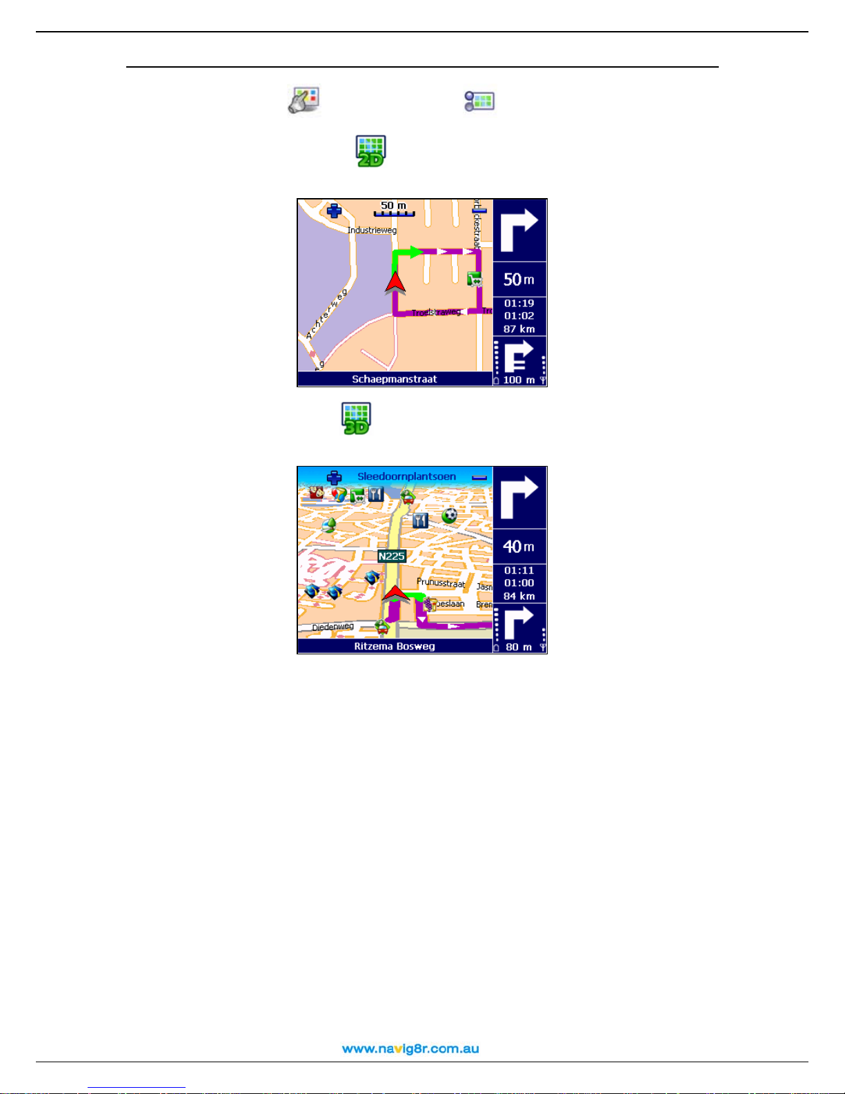
2D perspective / 3D perspective…………………………………………………………………………46
Set 3D angle……………………………………………………………………………………..…………….29
Show favourites / Hide favourites………………………………………………………………………..47
Show scale / Hide scale…………………………………………………………………………………….48
Select map……………………………………………………………………………………………………..49
Legend…………………………………………………………………………………………………………..49
Points-of-interest (POI)……………………………………………………………………………………..50
Zoom to………………………………………………………………………………………………………….50
Change settings……………………………………………………………………………………………….51
Backlight…………………………………………………………………………………………………………51
Language……………………………………………………………………………………………………….52
Units………………………………………………………………………………………………………………52
Volume…………………………………………………………………………………………………………..53
Route type………………………………………………………………………………………………………53
Avoid motorways …………………………………………………………………………………………….54
Avoid toll roads………………………………………………………………………………………………..54
Avoid ferries…………………………………………………………………………………………………….54
Automatic zooming…………………………………………………………………………………………..55
Configure alarm……………………………………………………………………………………………….56
Speed…………………………………………………………………………………………………………….57
Set date/time…………………………………………………………………………………………………..57
Vertical turn arrows / Horizontal turn arrows…………………………………………………………58
Calibrate screen………………………………………………………………………………………………59
Define your navigation experience………………………………………………………………………59
Points-of-interest (POI)……………………………………………………………………………………..59
Maintain POI……………………………………………………………………………………………………59
Add as POI………………………………………………………………………………………………………59
Rename POI……………………………………………………………………………………………………60
Remove POI…………………………………………………………………………………………………….61
Maintain POI category ………………………………………………………………………………………62
Add POI category…………………………………………………………………………………………….62
Rename POI category ………………………………………………………………………………………63
Remove POI category ………………………………………………………………………………………64
POI alarm………………………………………………………………………………………………………..65
Speed and Red light camera alarm……………………………………………………………………..66
Favourites……………………………………………………………………………………………………….67
Set home address……………………………………………………………………………………………68
Set office address…………………………………………………………………………………………….68
Add favourite…………………………………………………………………………………………………..69
Rename favourites……………………………………………………………………………………………70
Remove favourites…………………………………………………………………………………………….71
4

User Manual
Appendix………………………………………………………………………………………………………..72
Installing other geographic map(s) and voice instructions on the Memory Card………….72
Formatting your Memory Card……………………………………………………………………………73
How does GPS work?....................................................................................................74
Quick Reference Card – Navigate to a location………………………………………………………75
Customer Support…………………………………………………………………………………………….77
Disclaimer……………………………………………………………………………………………………….77
5

User Manual
Safety and Regulatory Information
Important Safety Notices and Warnings
Global Positioning System
The Global Positioning System (GPS) is a satellite-based system that provides location
and timing information around the Globe.
GPS is operated and controlled under the sole responsibility of the Government of the
United States of America, who are responsible for its availability and accuracy. Any
changes in GPS availability and accuracy, or in environmental conditions, may impact the
operation of your device .We cannot accept any liability for the availability and accuracy of
GPS.
Precautions and Notices
For your own safety, do not operate the controls of the product whilst driving.
Use this product prudently. The product is intended to be used only as a navigation aid. It
is not for precise measurement of direction, distance, location or topography.
The calculated route is for references only. It is the user's responsibility to follow the traffic
signs and local regulations along the roads. When you leave car, do not leave your device
on the dashboard or the car glass that is subject to direct sunlight. The overheating of the
battery can cause malfunction and /or danger. Remove the GPS, bracket and charger
from sight to reduce the risk of theft.
GPS is operated by the United States government, which is solely responsible for the
performance of GPS. Any change to the GPS system can affect the accuracy of all GPS
equipments.
GPS satellite signals can not pass through solid materials (except glass).When you are
inside a tunnel or building, GPS positioning is not available.
A minimum of 4 GPS satellite signals is needed to determine current GPS position. Signal
reception can be affected by situations such as bad weather or dense overhead
obstacles (e.g. trees and tall buildings)
The wireless devices may interfere with the reception of satellite signals and cause the
reception of the signal to be unstable. For better signal reception, it is recommended that
the GPS unit is positioned to have a clear view of the sky. I should also be positioned as to
not to obstruct the drivers view or the road ahead.
Aircraft and Hospitals
Use of devices with an antenna is prohibited on most aircraft, in many hospitals and in
many other locations. The device should not be used in these environments.
6
User Manual
1. Getting Started
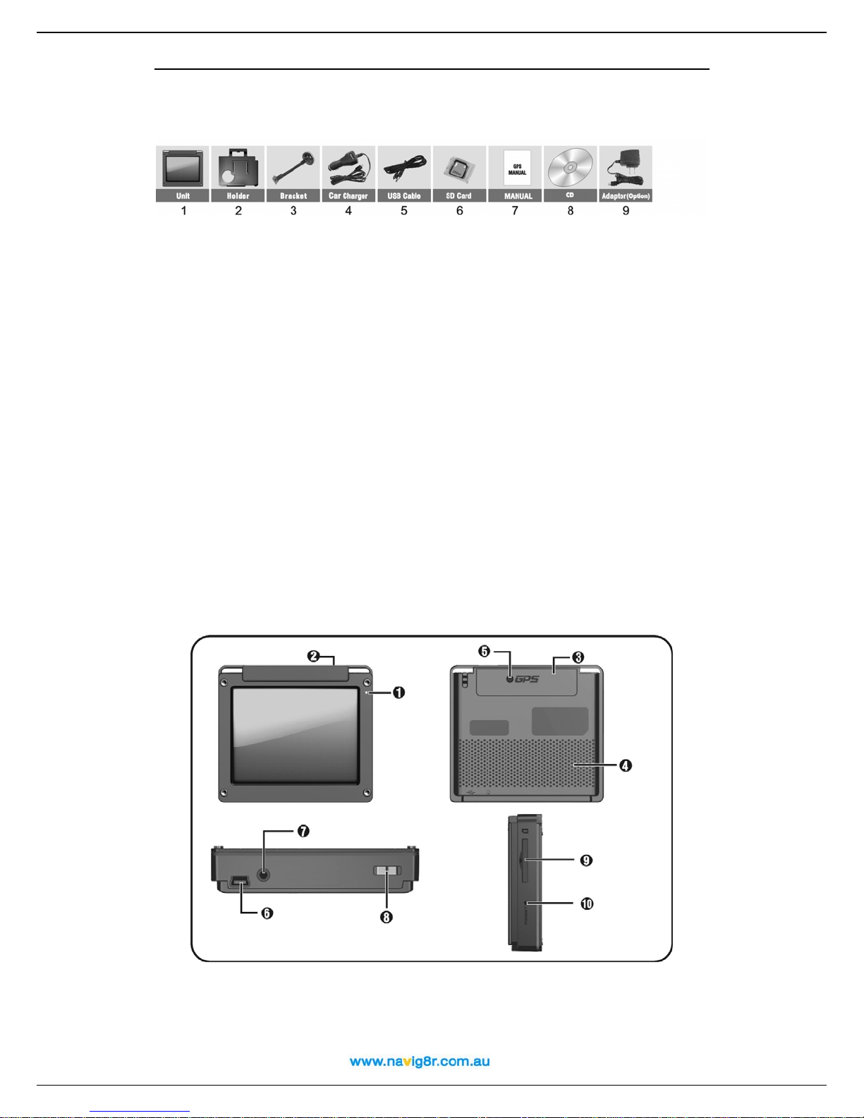
1.1Unpacking
Unpack your device box and identify the contents. You should have:
(1) GPS unit: Its main features are a touch-sensitive LCD screen, 1 SD card slot, 1 volume
control switch. Details see the photo below.
(2) Holder: Used to attach the GPS to the mounting bracket.
(3) Bracket: Used to mount the GPS unit to the Windscreen of the vehicle.
(4) Car Charger 12V DC cigarette lighter adapter: Used to provide power to your device
when it's in your vehicle.
(5) USB data cable: Used for connecting your device to a Windows PC
(6) SD card: Containing map data it is preinstalled in the GPS unit. (7)
(7) User Manual. (9)
(8) Installation CD: Containing PC connection software and Back up of maps installed on
the SD card.
(9) AC Adapter (Optional): The optional AC adaptor can charge and power your device
when It's not in your vehicle (AC Socket required). When you use the adapter, please
make sure it is cooled by placing it in a ventilated area.
*Note: please check optional accessories with local retailer/importer/distributor.
1.2 Over View
(1) Charger Indicator Light
(2) Saving Power Switch
(3) GPS Antenna
(4) Speaker
7

User Manual
(5) External GPS Antenna Connector
(6) USB Connector
(7) Earphone Jack
(9) SD Card /MMC Slot: for accessing
data and maps.
(10)Reset Key
(8) Unit Power On/Off
Note: Before using GPS navigation software and maps, you need to insert the storage
Card included with your device. Do not remove the card during GPS in operation.
Do not expose the device to high temperatures. We recommend that you do not leave the device
in direct sunlight for long periods or in an unattended car on sunny days.
High temperatures can cause permanent damage.
Do not attempt to service the device yourself! Do n ot open, puncture or disassemble the GPS
unit. Doing so will void the warranty can be dangerous.
1.3 Using Your Device in a Vehicle
A stand and a car charger are supplied with your device.
1.3.1 Using the Car Bracket
Caution:
-- Select an appropriate location for the bracket. Never place the bracket where the
driver's field of vision is blocked. Locate the Bracket as low as possible and Bend the rod
part of the bracket to adjust the driver’s view of the screen.
rd
-- If the car's windshield is tinted with a reflective coating, an external antenna (3
party
accessory) maybe required to route the Antenna to the top of the car through a window.
When closing the car window, be careful not to pinch the antenna cable (Cars with an
anti-jam window design may automatically leave adequate space as needed.).
1.3.2 Connecting the Car Charger
The car charger supplies power to your device when you are using the device in a car.
Caution: To protect your device against sudden surges in current, connect the car
charger only after the car engine has been started. Connect one end of the car charger
8

User Manual
to the power connector of your device. Connect the other end to the cigarette lighter in
the car to power and charge your device.
To Cigarette Lighter
1. Device power connector
2. Vehicle power connector
1.3.3 Charging the battery
1. Fully charge the battery before using your device for the first time
2. Connect the USB cable to the bottom of your device and connect.
3. Turn the computer On. The GPS unit cannot charge if there is no power to the USB
ports on your computer.
4. Charging the GPS unit with the USB cable will take about 24 hours. The charge
indicator glows amber when charging is in progress. Remove the GPS after 24 hours.
Charging the GPS with the optional AC adaptor
1. Connect the optional AC adaptor as shown above. The charge indicator glows
amber when charging is in progress. Do not disconnect your device from AC
power until the battery is fully charged, when the charge indicator turns green.
This will take a couple of hours.
1.3.4 Assembly
To get started, put the device into the holder and assemble holder with bracket. Take off
the protective film on the bottom or the suction. Then put the bracket onto a suitable
location of your windscreen or side window, make sure the window and the suction or
windscreen is clean. For best suction, it is recommended that the suction cup be
9

1
User Manual
moistened before affixing to the windscreen. When in a suitable place, push the leaver at
the base of the bracket towards the suction cup to secure a seal. Check the seal to
ensure that suction cup is working before releasing the GPS. Bend the post of the bracket
to position the screen in a comfortable position for the drive without obscuring the view
through the windscreen.
Note: Controlling 5 different levels of suction by pressing down the button (See below
picture)
Controlling 5 different
levels of suction by
pressing down the button
Note: Some newer vehicles may have a heat reflective shield embedded in the
windscreen. In some cases this can prevent proper GPS signal reception. If this turns out
to be a problem in your vehicle, you will need to purchase and install a 3
external antenna kit.
Under normal journey conditions, the suction mount is perfectly sufficient to hold the
bracket and GPS in position. Suction may be lost if left overnight, due to condensation
and low temperature. For this reason, and for security, we recommend removing both
the suction mount bracket and the device when leaving your vehicle overnight.
To remove the bracket, three steps as below:
Press the 2 buttons on the side of the lever, pull back lightly and then take off the suction.
If the bracket still doesn't detach from your windscreen, tug gently on the clear plastic tab
at the edge of the suction mount, to break the vacuum seal.
rd
party GPS
1. Press 2 sides button
2. Pull back lightly
3. Take off the suction
0
1
User Manual
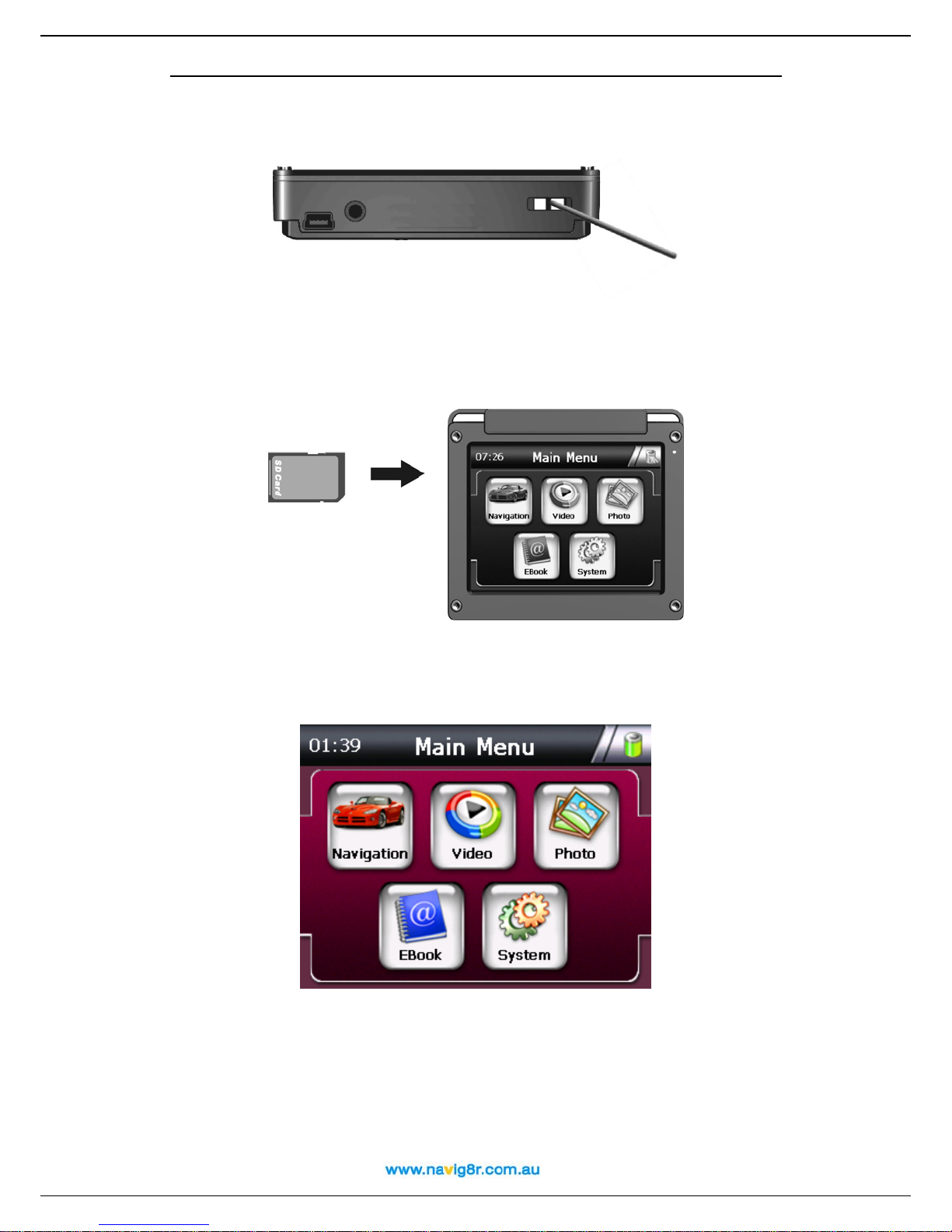
1.4 Starting up
Push the System Power switch to the "ON" position prior to use, and leave it on "ON"
position. (Suggestion: Please turn GPS unit "OFF" if it is not to be used for long periods.)
Insert the supplied SD card into the slot at the bottom of device if not already fitted. When
the card is inserted the GPS unit will make a noise to show that it has detected the card.
The "Main Function Operation Screen ".
Then select the functions you require from the GPS system main menu..
1.5 Power saving
1
1
User Manual
Press the power button
on the top side of your device to turn on and off your device
for saving power. When you press the power button to turn off the unit, your device
actually enters a suspend state and the system stops operation. Once you turn on the
system again, it will resume at the place in the system where you were last using. This is
not recommended for long or extended periods as the unit will still draw a small amount
of power from the battery. If left too long it will discharge the battery.
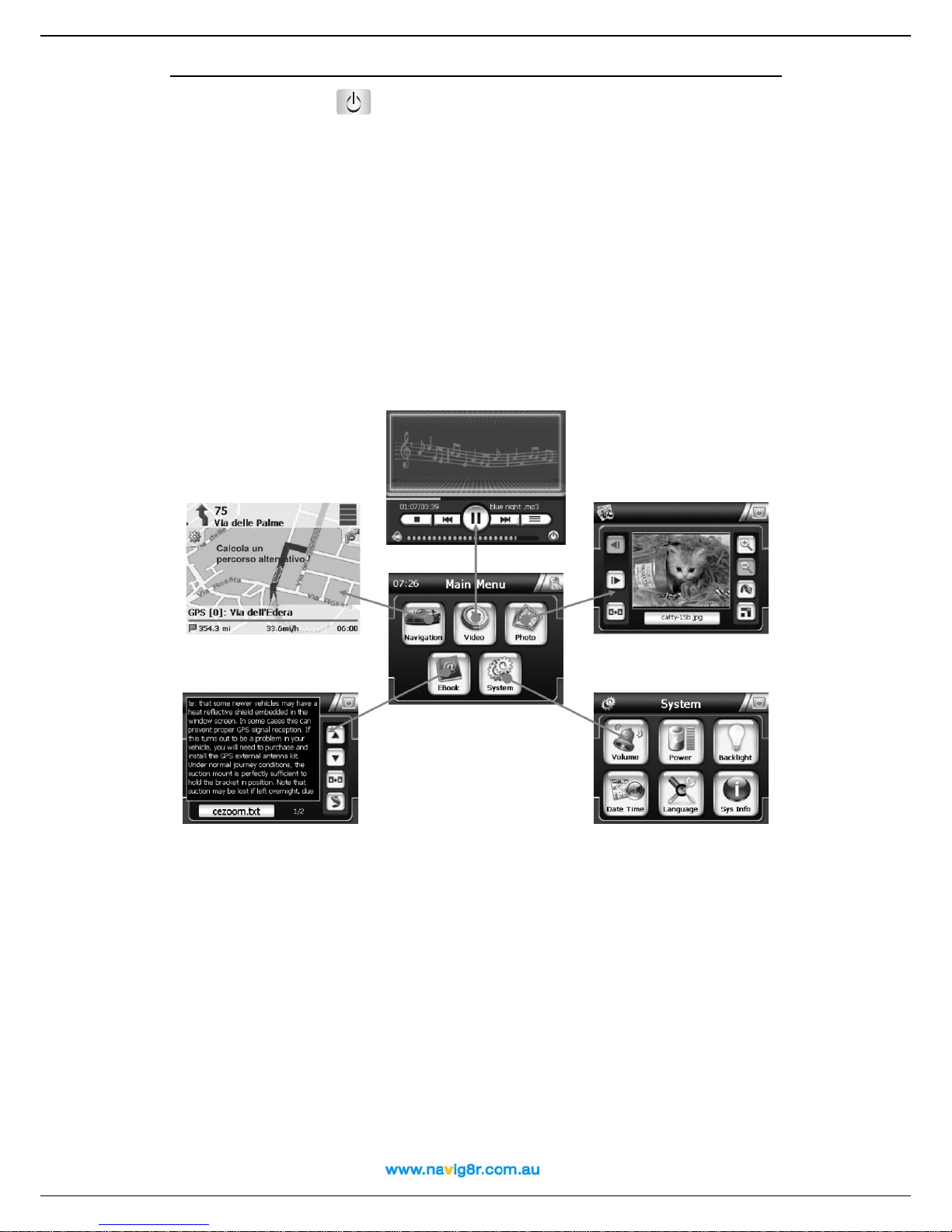
2. Main Menu Selection
Main Menu is the start of all functions. It includes five function icons listed below. Choose
the desired functions Navigation, Video player, Photo, E-book or System setting.
2.1 Navigation
Please refer the navigation software user manual for the details.
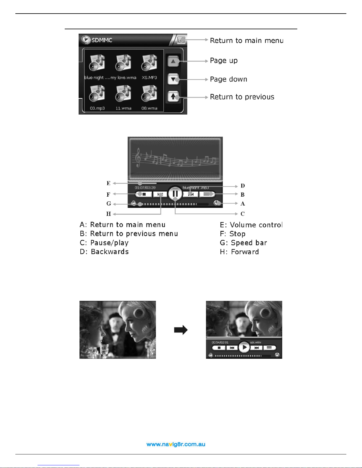
2.2 Video Player
This feature requires compatible video or music files be transferred to your SD card.
Please refer to section 3.9 for instructions.
1) Tap t h e i c on "Video" on the main menu and enter into following display.
2
1
User Manual
Select the music or Video file you wish to play, it will play automatically, and you will see
the display as below:
When playing Video files, you will enter into full screen display, wherever you tap the
screen, it will display the play back controls, touch the screen again, and it will go back to
full screen.
2) Tap the "Return to Main Menu" button to return to the main menu.
2.3 Photo
1) Tap " Photo" on the main menu and enter into the following display
3

1
User Manual
2) Tap the file on the screen and enter into the following picture.
3) Tap the "Return to Main Menu" button to return to the main menu.
Tips: Tap FULL SCREEN button, it will display in full screen.
Tap PREVIOUS or NEXT button to view the pictures.
If the picture is too big or the device does not support the format, it will display
a blank screen or “Cannot read” error message.
4

1
User Manual
2.4 E-Book
1) Tap "E-book" in the main menu and enter into the following display.
2) Tap the file on the picture and enter into the following display.
A: Return to main menu
B: Previous page
C: Next page
E: Pages chose
F: Current page/total pages
G: Current file name
D: Return to previous menu
3) Tap the "Return to Main Menu" button to return to the main menu.
2.5 System
Tap the icon "System" on the main menu and enter into the following setting.
5

1
User Manual
A: Return to main menu
B: Backlight
C: System information
D: Language
E: Power
F: Volume
G: Date and Time
6

1
User Manual
1) Tap the icon "Backlight" and enter into the following display.
Tap t h e “ -“ button to decrease the backlight or the “+” to increase the backlight
2) Tap the "Return to Main Menu" button to return to the System Menu.
3) Tap the icon "Sys Info" and enter into the following display
Tap "Calibration" set the calibration of the touch screen.
Follow the information on the screen. Press the centre of the cross and then follow the prompts
displayed by the system. When prompted tap the screen to finish.
3) Language
A) Tap the "Language" icon and enter into the following display.
7

1
User Manual
B) Tap "<"or ">" icon to select the language. This will not affect the language used in navigation
mode.
c) Tap the "Return to Main Menu" button to return to the System Menu.
3) Power
Tap the icon "Power" and enter into following display. This is the current status of the battery level.
When connect to a power source the bar will flash to indicate the that the GPS is being charged.
Tap the "Return to Main Menu" button to return to the System Menu.
5) Volume
A) Tap the icon "Volume" and enter into volume setting display.
B) Tap the "-" or "+" to adjust volume of speaker.
C) Select or disable the “Enable sound for Taps” option
D) Tap the "Return to Main Menu" button to return to the System Menu.
8

1
User Manual
6) Date and Time
A) Tap the icon "Date and Time" and enter into the following display.
B) Tap DATE icon and use < or > icon to adjust the date.
C) Tap the "Return to Main Menu" button to return to the Date and & Time Menu.
D) Tap TIME icon and use < or > icon to adjust the time.
E) Tap the "Return to Main Menu" button to return to the Date & Time Menu.
F) Tap the "Return to Main Menu" button to return to the System Menu.
3.1 I can't find an address.
3.0 FREQUENTLY ASKED QUESTIONS
9

User Manual
Please make sure you have correctly spelled your entry. If you do not know how an address is
spelled correctly, simply enter the parts of the address, you know for sure (e.g. "Parr", "Parra" for
Parramatta Road or for the Suburb). Then browse in the result list and look for the address. Also
make sure that the city in which you are looking for an address is correct.
Sometimes the official postal address differs from the address you are looking for. In that case,
search for an address nearby that you know of and browse on the map.
If you find the address on the map but you can not find it while searching for it, please contact the
manufacturer or your retail know of and browse on the map store for information about software
updates.
3.2 There is a failure in the map / POIs are missing.
If you detect an error in the map data (e.g. a street is missing completely), we would like to inform
our map data provider. Please visit the Navteq website and use the Map Reporter feature at the
following location to lodge any map data error.
Http://www.navteq.com.
3.3 Voice instructions are unclear in a specific situation:
If you could not fully understand the voice command for a maneuver, either hit the repeat
command button or ask your companion to take a look at the map.
3.4 I have problems to get a GPS fix.
If you have problems getting a satellite fix with the GPS (you can see how many satellites are
being received on the main menu at the bottom left) please make sure, that you are outside and
the GPS antenna has a good visibility to the open sky.
3.5 Where can I get technical support?
Please visit the following website for further FAQ’s and tech support details.
Http://www.navig8r.com.au/page/FAQ.htm
3.6 Where can I get software updates?
Information on the availability on updates will be posted at the following location.
Http://www.navig8r.com.au/page/downloadsupdates.htm
3.7 Where can I get additional maps and guides?
Information on the availability of additional maps will be posted at the following location.
http://www.navig8r.com.au/page/maps/index.htm.
3.8 How to Install the MSActiveSync? (Win2000 and XP users only)
ActiveSync allows you to establish a connection and transfer files (i.e.MP3 Files) between your
device and your computer.
Caution: Do not connect your device to your computer before ActiveSync is installed.
Download the "MsActiveSync" from following website web site and install.
http://www.microsoft.com/windowsmobile/activesync/activesync45.mspx
Step1: Turn on your PC and your device, then connect the GPS by the supplied USB cable.
Step2: After the Wizard display, Select "NO" and then press "Next".
20

Step3: Tap "Explore" button
User Manual
.
Step4: Example: Copy the Map file to the "Cities" file of SDMMC folder.
Other files can be placed in the root directory of the card as follows
Put Music files & Movie files to Video Directory
Put photos and pictures in the Photo Directory
Put the web files to TEXT Directory
Put the map in the Cities Directory
If the folders do not exist they will need to be created
3.9 How to Install the Windows Mobile Device Centre (For Vista users only)
Windows Mobile Device Centre allows you to establish a connection and transfer files (i.e.MP3
Files) between your device and your computer.
Caution: Do not connect your device to your computer before Windows Mobile Device is installed.
Download "Windows Mobile Device" from following website web site and install.
http://www.microsoft.com/windowsmobile/devicecenter.mspx
Step1: Turn on your PC and your device, then connect the GPS by the supplied USB cable.
Step2: When the following screen is displayed, Select "Connect Without Setting Up Your
21

Device".
User Manual
Step3: Click on “File Management” and then on “Browse the Contents of your device”.
Step4: Example Copy the Map file to the “Cities” folder of “SDMMC” folder.
22

User Manual
Other files can be placed in the root directory of the card as follows
Put Music files & Movie files to Video Directory
Put photos and pictures in the Photo Directory
Put the web files to TEXT Directory
Put the map in the Cities Directory
If the folders do not exist they will need to be created
3.10 How to download the files from the website and directly to my SD Card?
If your computer is fitted with an SD card reader files can be transferred directly to the card
Step1: Turn your PC and insert the SD card directly to the Slot for the SD card in the card reader
Step2: Locate the icon that represents the slot in the “My Computer” Window.
Step3: Copy files to the card as you would copy file to any other drive/folder on your computer.
3.11 What Kind of formats does this device support?
• Supports Music/Video formats: AVI, ASF, WMV, WMA, MP3 WAV
• Supports image file formats: JPG, JPEG, BMP, GIF.
• Supports E-Book Formats: TXT.
Certain AVI files may be encoded in a format that is not compatible with the GPS unit. A blank
screen may be displayed if the encoding is not compatible. Video or music files with copy
protection cannot be played on this device.
4. Connecting to Your PC
There are two ways to update or change the maps, the software, or the multi-media files to your
device.
1: Using a Card-reader
1.1 Insert the SD Card to the card-reader.
1.2 Copy the update maps/software/multi-media files to the correct folder/directory on your SD
Card.
1.3 Take out the SD Card from the card-reader and insert to your device.
1.4 Navigate through the menu to the desired function to check the downloaded files.
2: Using MSActiveSync or Windows Mobile Device software
2.1 Set up the MSActiveSync/Windows Mobile Device on the PC ( See 3.8 How to install the
MSActiveSync? Or 3.9 for Windows Mobile Device)
2.2 Connect the device and PC via USB cable
2.3 MSActiveSync or Windows Mobile Device will run automatically once the device connect with
PC (GPS must be turned on)
2.5 Put the map/software/multi-media files to the correct folder/directory on your SD Card
***Remarks: Map and software updates must done according to instructions provided at the
time of downloading.
23

User Manual
5. Troubleshooting and Maintenance
5.1 Resetting Your System
Resetting your system is similar to restarting your computer. Occasionally, you may need to reset
your device. For example, you should reset your system when it stops responding or appears to
be "frozen" or "locked up.
To reset your system, press the Reset button on left side of your device.
If your device still does not respond after being reset, you can use the following steps to clear the
memory, and reset the system settings to factory defaults.
• Disconnect all cables, including the AC Adaptor, from your device.
• Use the stylus pen or your finger to slide the ON/OFF switch to the OFF position
• Wait for 1 minute and then slide the switch back to the ON position.
• Your device will automatically turn on and the Main screen will appear.
Note: Once you clear the memory with this ON/OFF switch, all the settings made in the System
Settings will be erased, you will need to re-enter any personal settings, including time and date
once after resetting the GPS.
5.2 Troubleshooting
5.2.1 Power Problems
Power does not turn on when using battery power
> Make sure the power switch is already in the ON position
> The remaining battery power may be too low to run your device.
> Connect an AC adapter the Car Charger to your device to power the device
.
5.2.2 Screen Problems
A) Screen is off
If the screen does not respond even after you press the power button, try the following in order
until the problem is solved:
> Connect the AC adapter to your device and to external AC power.
> Connect the Car Charger to your device and to external DC power.
>Reset your system.
B) Screen responds slowly
Make sure that your device is not running out of battery power.
C) Screen freezes
Reset your system.
D) Screen is hard to read
>Adjust the Backlight setting for the GPS
>Move to a location with more light
>If the problem still exists, reset your system.
E) Inaccurate response to stylus pen taps or finger tip
Recalibrate the touch screen.
5.2.3 Connection Problems
Cable Connection Problems
> Make sure that the device and your computer are both turned on before trying to establish a
connection.
> Make sure that the USB cable is securely plugged into the USB port on your computer and into
the device.
> Reset your device before connecting the cable. Always disconnect your device before you
restart your computer.
5.2.4 GPS Problems
24

User Manual
When there are no valid signals available, consider the following:
> Make sure that the GPS has a clear view of the sky.
> Note that the GPS reception can be affected by:
- Bad weather.
- Dense overhead obstacles (e.g. trees and tall buildings).
- Other wireless device in the car.
- Reflective car window tint.
5.2.5 Voice Too soft Or No Voice
If earphones is in the earphone jack, the speaker will be cancelled, Remove the earphones from
the unit. Check the Sound Set on your System, make sure your voice setting is correct and the
voice volume is set correctly.
5.2.6 Why can not use my download files
• The file format is not supported
• The file is not in the correct Route
• MP3 Route is as : SD card \media\mp3
• MP4 Route is as SD card \media\mp4
• JPG,BMP files Route is : SD card \media\pic
• Map and navigation Voice is: SD Card \Cities\...
5.3 Maintaining Your Device
Taking good care of your device will ensure trouble-free operation and reduce the risk of d amag e
to your device.
> Keep your device away from excessive moisture and extreme temperatures.
> Avoid exposing your device to direct sunlight or strong ultraviolet light for extended periods of
time.
> Do not place anything on top of your device or drop objects on your device.
> Do not drop your device or subject it to severe shock.
> Do not subject your device to sudden and severe temperature changes. This could cause
moisture condensation inside the device, which could damage your device. In the event of
moisture condensation, allow the device to dry out completely before use.
> Take care not to sit on the device. We advise not to carry the device in one’s back pocket for
that reason.
> The screen surface can easily be scratched. Use the stylus or your fingers to tap on the screen.
Avoid touching it with any sharp objects. Non-adhesive generic screen protectors designed
specifically for use on portable devices with LCD panels may be used to help protect the screen
from minor scratches but may impede the sensitivity of the screen.
> Never clean your device with it powered on. Use a soft, lint-free cloth moistened with water to
wipe the screen and the exterior of your device. The use of commercial house hold cleaners may
damage the screen and should not be used.
> Do not use paper towels to clean the screen.
> Never attempt to disassemble, repair or make any modifications to your device.
Disassembly, modification or any attempt at repair could cause damage to your device and even
bodily injury or property damage and will void any warranty.
Do not store or carry flammable liquids, gases or explosive materials in the same compartment as
your device, its parts or accessories.
6. Battery, Charger and Safety Precaution
6.1 About Charging
> Use only the optional AC adapter and the DC Car Charger supplied with your device. Use of
another type of AC adapter or Car Charger will result in malfunction and/or danger. Charging via
the USB cable is possible but due to the lower current of USB ports the charging process will take
considerably longer.
> The AC adapter input rated 100~240V AC,50/60Hz, 0.35A, output rated +5V DC / 2.0 A,DC Car
Charge input rated DC input 12V DC output 5V, 2A.
> The Battery in not user replaceable.
6.2 About the AC Adapter (Optional) and the Car Charger
> Do not use the adapter or the car charger in a high moisture environment. Never touch the
adapter when your hands or feet are wet.
> Allow adequate ventilation around the adapter or the car charger when using it to operate the
device or charge the battery. Do not cover the AC adapter or the car charger with paper or other
objects that will reduce cooling. Do not use the AC adapter while it is inside a carrying case.
> Connect the AC adapter to a proper power source. The voltage requirements are found on the
product case and/or packaging.
> Do not use an adapter or the car charger if the cord becomes damaged.
25

User Manual
> Do not attempt to service the unit. There are no serviceable parts inside. Replace the unit if it is
damaged or exposed to excess moisture.
6.3 About the Battery
> Use a specified charger approved by the manufacturer.
CAUTION: This unit contains a non-replaceable internal Lithium Ion battery. The battery can burst
or explode, releasing hazardous chemicals. To reduce the risk of fire or burns, do not
disassemble, crush, puncture, or dispose of in fire or water.
> Important instructions (for service personnel only)
- Replace only with the same or equivalent type recommended by the manufacturer.。
- The battery must be recycled or disposed of properly.
- Use the battery only in the specified equipment.
CAUTION: Risk of explosion if battery is replaced by an incorrect type. Dispose of used batteries
according to the instructions.
7. Specification
CPU: Atlas III/372MHz
SDRAM: 64M Bytes
ROM: 32/64 MB NAND Flash
Display: 3.5" TFT LCD with Touch Panel, resolution 320 x 240
Map storage: SD/MMC Card
USB Device: USB 1.1
OS: Microsoft Windows CE.NET 5.0
Working temperature: 0~60oC
Storage temperature: -20oC~80oC
Power: 5V, 2A
8. Warranty
This product is covered by a 12months warranty from the date of purchase against failure or
manufactures defects.
It is covered by a 14 day DOA (Dead on Arrival) replacement policy. If during the first 14 days after
purchase the unit fails please contact Tech support as per the contact details at the following
location http://www.navig8r.com.au/page/FAQ.htm to confirm the problem. After confirming the
fault with the unit it should be returned to the place of purchase where the unit should be
replaced.
After the 14 day DOA period please contact Tech Support as per contact details here
http://www.navig8r.com.au/page/FAQ.htm for information on the warranty return processes.
A proof of purchase is required with any warranty return and warranty may not be honored if not
provided.
International warranty is not provided for. If product is purchased outside of Australia please
contact the place of purchase for their warranty returns process.
The following items are not covered by warranty.
• Damage to unit through neglect or misuse.
• Damaged Screens. Unless reported to place of purchase within 2 days of purchase.
Units must be new and unused, with all packaging, accessories and documentation
when returned. Units with used accessories will be deemed to have been used and the
warranty will be void.
• Water/Liquid damage.
• Damage caused by Windscreen holder falling from Windscreen.
• Marks or scratches on screen caused by use.
• Impact damage of any type.
• Errors in maps or incorrect directions. Please report any errors in map data to the Map
Reporting Function at the following location http://www.navteq.com/
26

User Manual
Navigation
Conventions and abbreviations
These are the conventions used in this user manual:
n, o, p Step-by-step instructions.
Locations,
Change settings
, ,
Menus and submenus in your Navig8r.
Icons in your Navig8r.
,
Amsterdam
restaurant
Examples.
Warnings or important information.
These are the abbreviations used in this user manual:
2D
3D
GPRS
GPS
IT
POI
Bi-dimensional
Three-dimensional
General Packet Radio Services (technology)
Global Positioning System
Information Technology
Point-of-interest
USB
Universal Serial Bus
Product Activation
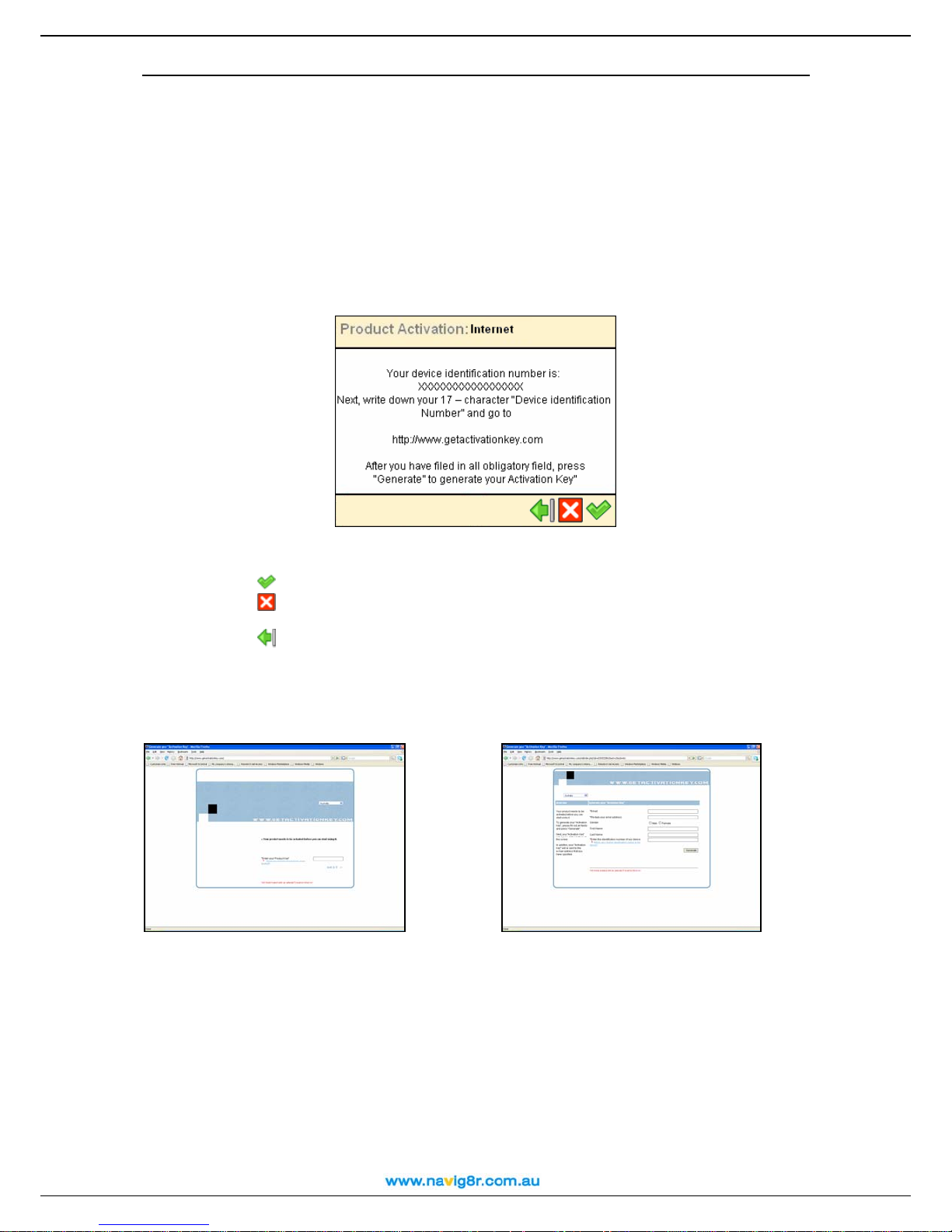
The Product ID is supplied with the software CD in the packaging with the GPS unit! The
Product ID cannot be replaced if lost.
At the first start up of your GPS system, when you click on the navigation icon, the first navigation
feature you will be presented with is the Product activation screen.
Activation is required for this product and is required to be performed over the internet.
Options.
27
User Manual
Later: Allows you to continue using the GPS unit as normal. You will be presented with
the above screen at each start up and from time to time with the selection of certain menus to
remind you activation is still required.
Activate: Selecting the Activate button will take you to the following screen to allow you
to activate the GPS system. Please follow all on screen instructions.
You will not be eligible for any update that may be available for this product until Activation is
completed.
Record and store the Product ID and the Device ID in a safe place. They will be required in the
event the software is reinstalled on the GPS unit.
Write down the number provided in the above screen and record it along with the Product
ID code.
Click on
Click on
to continue with Activation.
to cancel the Activation and return to the Main system Menu.
Click on
to return to the previous screen to delay the activation of this product.
Open a web browser and visit http://www.getactivationkey.com to get the activation key, which is
required to complete the Activation of your GPS System.
Enter in the Product ID Code and click
on “NEXT” to continue.
Fill in the above screen. Fields marked with *
are required. When all required fields have
been completed, click on “GENERATE” to
get your activation key.
The Activation Key will be displayed on the screen and an email will be sent confirming the
Activation and to provide you with a copy of the Activation Key.
28

User Manual
On the GPS unit, enter the Activation code as presented on the Activation web site and then
Your GPS system is now ready to use.
IF an error message is reported please go back and ensure that the Product ID, the Device ID
and the Activation code have been entered correctly!
29

First steps
Understanding the navigation screen
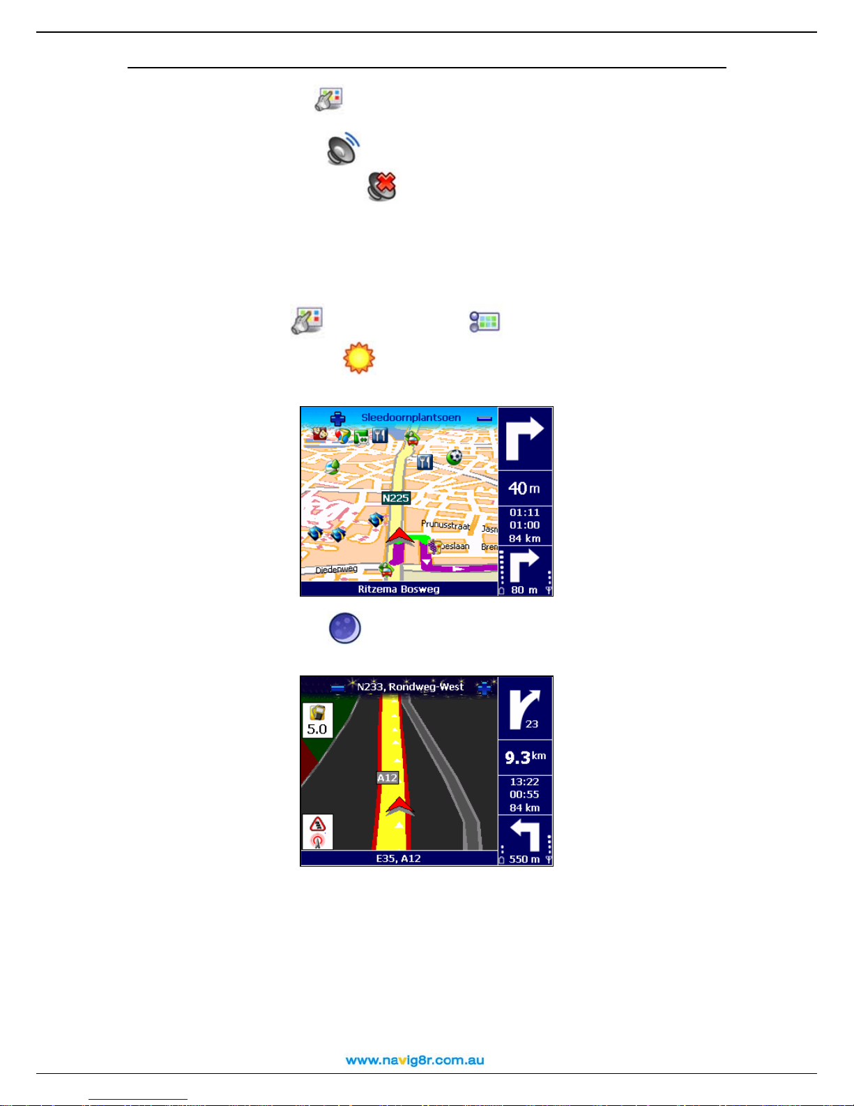
The main elements of the navigation screen are presented below.
User Manual
Element Description Element Description
1
2
3
4
5
6
7
8
9
You can tap several areas of the navigation screen and display additional information:
Zoom in
Next street
Zoom out
Current turn
Remaining distance to the
current turn
Estimated time of arrival
Remaining time to
destination
Remaining distance to
destination
Next turn
10
11
12
13
14
15
16
17
18
Strength of GPS signal
Remaining distance to the next turn
POI alarm
Current route
Current street
GPS arrow (current position)
Point-of-interest
Battery level
Exit information
• Tap the map area to open the Main Menu screen.
• Tap the top-right area (4) to repeat the last voice instruction.
• Tap the middle-right area (including 5, 6, 7 and 8) to display the Statistics screen.
30

User Manual
• Tap the bottom-right area (including 9, 10, 11 and 17) to display the GPS information
screen.
Depending on your preferences and the specifications of your device, the navigation screen will
be displayed as follows:
Vertical turn arrows
Horizontal turn arrows
31

User Manual
Moving around the menus
Use the following buttons to move through the product:
Butto
n
Action
Go to the next screen or confirm choices made
on the current screen. For example, confirm
language selection or start navigating.
Return to the previous screen or abort the current
action. For example, return to the route type
selection or cancel a search action.
Jump to the main navigation screen, regardless
of the current screen.
(De)Select an item or option.
Move one screen up.
Move one screen down.
Filter long lists of search results.
Delete the selected item in a list.
Delete all items in a list.
The menus will be displayed as follows:
Moving around the map
To view the map in a more convenient way, use the following buttons:
Button Action
Enlarge the map view (zoom in). As you zoom in,
more detail will be displayed on the map.
Decrease the map view (zoom out). As you zoom
out, less detail will be displayed on the map.
You can scroll the map by selecting & holding the map and dragging it in the desired direction.
Using the keyboard
The keyboard is displayed automatically when you want to enter a name (numbers, letters, or
both), for example an address.
To display letters, select ABC.
To display numbers and other symbols, select 123.
To delete characters, select Backspace
.
32

User Manual
Using the filter
The filter Icon can be used when a list of search results are displayed and is shown in the lower left
of the screen.
In longer lists, select the filter
to narrow your search results.
Enter a letter, a group of letters, or a word.
That keyword is searched for in all items of the list.
The keyword can be detected anywhere in the list: at the beginning, in the middle or at the end of
an item.
Using the touch screen and stylus
The touch screen allows you to make selections, browse the map or enter data. Touch the
desired object on the screen, with the stylus or simply with a finger.
33

User Manual
Main menu
First of all, spend a few minutes and read the following overview of the main features of your
Navig8r.
Icon Name Description
Select this button to select a destination and start
navigating to it. Simmply select your home address or
your office address; type the name of a particular
Navigate to
location; pick a Favourite location or a recently visited
address (History); browse a huge collection of
points-of-interest around your current position or
around your destination. Browse the map, select a
location and start navigating to it.
Select this button to customize your travelling
experience. Switch from day view to night view.
Display your route in 2D or 3D perspective. Set the
Map options
map perspective. Show or hide your favourites or the
map scale. View the legend and change colours.
Choose which points-of-interest you want to display
on the map.
/
Sound on / Sound
off
Points-of-interest
Favourites
Zoom to
Change settings
Plan a route
Navigate via
Switch the speaker on or off.
Select this button to define and maintain categories of
points-of-interest. Fill these POI categories with
locations you visited or discovered during your trips.
Set alerts.
Select this button to store and maintain addresses or
destinations that you visit frequently or that are of
great importance to you. Save them as favourites.
Add favourites to your trips.
Think of this button as a powerful tool to locate a
particular location on the map.
Customize the overall functioning of the product. Set
the language of the user interface and the voice
instructions. Set the backlight, the time indicator or the
automatic zooming. Switch from metric units to
imperial units. Control the sound volume of the voice
instructions. Specify the preferred type of route for
travelling. Set safety indicators, including alarm and
speed. Specify what to avoid along your route
(motorways, toll roads, ferries).
Choose your departure location, your destination
location and, optionally, as many stopovers
(intermediate locations) as you need. Then, calculate
the route, read the route description and start
navigating.
Select this button to compose a route that contains
one or several stopovers and start navigating. Choose
at least the departure location and destination
location; if your route includes several stopovers
(intermediate locations), add each of them as another
waypoint to your route.
GPS information
Help
Statistics
Check the status of the GPS receiver.
Access the list of help topics and the copyright
information.
View statistical data about your current trip.
34

Navigate to a location
Now you are ready for your first trip. Select a destination and start navigating.
User Manual
When you are in the Navigate to
Icon Name Description
For details about finding locations, read the Working with locations chapter.
Working with locations
Locations, Addresses, Places and Points on the map, these are the basic elements that you can
use to compose a new trip. A location can be your departure, your destination, or any
intermediate waypoint.
How to take advantage of the available locations?
Home
Office
Location
Favourites
History
POI around GPS
position
POI around
destination
Point on map
screen, select:
This is an address or location you frequently
navigate to, for example your home address.
This is an address or location you frequently
navigate to, for example your company
headquarters.
Search for a location by typing its name.
These are the addresses or locations you saved
for future trips. Instead of searching for a location
each time you need it, you can save it as a
favourite and select it as often as you want.
Here you can find the locations that you have
visited recently.
These are points-of-interest (POI) around your
current GPS position.
These are points-of-interest (POI) near the
destination of your trip.
Browse the map and indicate any location.
• Search locations by name;
• Search the categories of points-of-interest around your current location or around
your destination
• Define your home address or your office address ;
• Customize your favourites ;
• Organize the locations you visited recently (History) ;
• Scroll over the map and indicate any location.
The possibilities are endless!
Navigate to your home address
Imagine that you have just finished a business meeting in an unknown city and all you want to do
now is go home with as little complication as possible. With the Navig8r its possible with just a
;
35

press of the button
User Manual
n In Main Menu
, select Navigate to .
o Select Home
.
That’s all! Now you can start navigating to your home address.
This option is available only if you have defined your home address before!
Navigate to your office address
With your Navig8r, it’s so easy to start travelling to your workplace, be it an office, a university or
a construction site.
n In Main Menu
, select Navigate to .
o Select Office
.
That’s all! Now you can start navigating to your office address.
This option is available only if you have defined your office address before!
Find an address and navigate to it
You are driving to an important meeting. But, suddenly, your secretary informs you that there is a
last-minute change: the meeting will take place in another city and in another hotel. Switch on
your device, search for this location, and start navigating to it. All in a few seconds!
n In Main Menu
, select Navigate to .
o Select Locations
.
p Type the name of the city, for example Amsterdam or just amst. Because the list of
possible locations could be large, narrow your search by typing another keyword, for
example hotel or just hot. When you have entered all search strings, confirm them
.
q Wait for a few seconds. When the list of results is displayed, pick out the location that
you are looking for. Confirm your choice
.
36

User Manual
That’s all! Now you can start navigating to your destination.
If no result is found, repeat step p and enter another search string!
If results do not display the location being searched for, please try removing the road type
from the search field. Then use the filter
to refine your search with post code or the first few
letters of the suburb.
Navigate to a favourite location
Let’s say that you frequently travel to the same location, for example your best friends, a ski
resort or golf course. These are your favourite locations. Would you like to store them into a
personal folder? You will never lose them again! Your Navig8r lets you carry them with you, find
them quickly and easily navigate to them.
n In Main Menu
, select Navigate to .
o Select Favourites
.
p The list of locations you have saved before as favourites is now displayed on the screen.
Select the filter if necessary. Select the location you need and confirm your choice
.
That’s all! Now you can start navigating to your destination.
If no favourite location was saved before, the list of favourites is empty!
Navigate to a recently visited location (History)
Let’s say that last week you had a great time visiting a national park in the mountains. This
weekend you would like to go to that same location again. You can try to remember all travelling
details, but that’s not always easy. Or, you can simply go to your History list and find the address
you visited last week. Then, select it as your destination for this weekend.
n In Main Menu
, select Navigate to .
37

User Manual
o Select History
.
p The list with the locations you have visited recently is now displayed on the screen.
Select the filter if necessary. Select Delete
all
to delete all items. Select an item in the list and confirm your choice .
to delete the selected item; select Delete
That’s all! Now you can start navigating to your destination.
If this is your first trip, the Select from history list is empty!
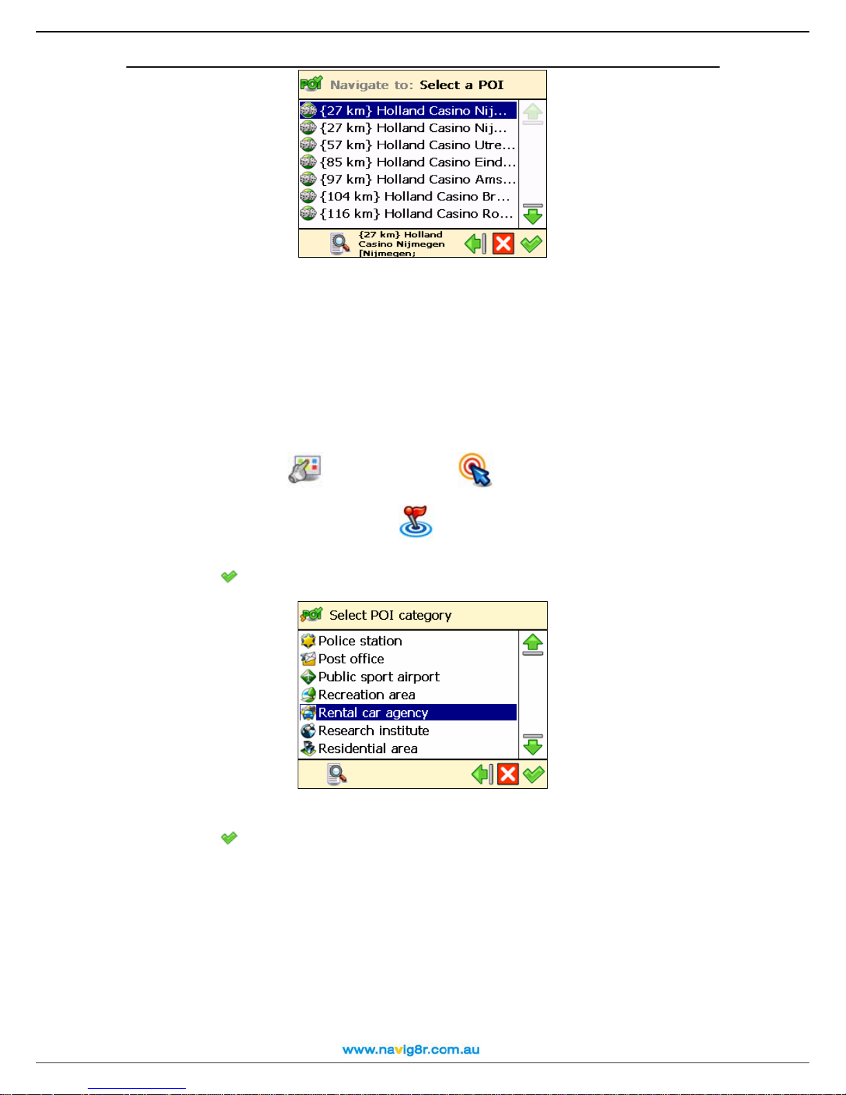
Navigate to a POI around your GPS position
Let’s say that you are spending your holiday in an unknown city (which is now your current GPS
position). You would like to visit as many points-of-interest as possible, for example museums,
casinos and libraries. You could ask the hotel personnel for details and driving instructions, but
that takes time. Or, you can use your device to select a POI category and then a specific POI.
Then, it’s up to you to decide which location you want to visit first!
n In Main Menu
, select Navigate to .
o Select POI around GPS position
.
p Select a relevant POI category, for example Casino and confirm your choice
.
q The results are sorted by distance: the first POI in the list is the closest to your GPS
position. Select the filter if necessary. Select an item from the list and confirm your choice
.
38
User Manual
That’s all! Now you can start navigating to your destination.
If there is no location that meets your search criteria, the “No search results!” message is
displayed!
An active GPS signal is required to use this feature!
Navigate to a POI around your destination
Let’s say that next week you will have a business trip to an unknown city (your future destination
for a few days). You would like to know in advance where to find a bank, an ATM or the convention
centre. Simply use your device to select a POI category and then an address. Then, it’s up to you
to update your agenda.
n In Main Menu
, select Navigate to .
o Select POI around destination
.
p Select a relevant POI category, for example Rental car agency and confirm your
choice
.
q The results are sorted by distance: the first POI in the list is the closest to your
destination. Select the filter if necessary. Select an item from the list and confirm your
choice
.
39

User Manual
That’s all! Now you can start navigating to your destination.
If there is no location that meets your search criteria, the No search results! message is
displayed!
Find a point on the map and navigate to it
Let’s say that you are on holiday in a region you visited last year. You have great memories about
a particular location with a superb panorama, but you can’t remember its name. All you
remember is the approximate location on the map. On the screen, browse the map, see where
you are right now (your current GPS position), then search and select that special location. Then
start navigating to that location. Fast and simple!
n In Main Menu
, select Navigate to .
o Select Point on map
.
p The map and your current position
display more details on the map. Zoom out
(GPS position) are displayed. Zoom in to
to view a larger section of the map. Select
& hold and drag the map in the desired direction. When you see on the map the location
of your memories, select it. The pointer
indicates this location on the map.
q Select Navigate to
That’s all! Now you can start navigating to your destination.
to choose this location as your destination.
40

Navigate to a destination via intermediate points (Navigate via)
Let’s say that today you have a very busy program. You have to drive to your office; you have a
business lunch; you must drive home and pick up your family and go shopping; and finally, you
want to go to the cinema. Think of each location as a destination: when you reach the first location,
the second location becomes your next destination; and so on. Add each location as another
stopover to your trip. It’s simple and fast!
User Manual
n In Main Menu
o The Overview of waypoints screen contains a list of locations you have selected
before, or locations you intend to include into your next trip. Select a single waypoint and
then confirm your choice
Optionally, you can:
, select Navigate via .
.
• Select Save route , type a relevant name and then confirm your choice to
save the current group of waypoints.
• Select Load waypoints and then confirm your choice to load a group of
waypoints, saved during a previous trip.
• Select Move up to move a location up in the list. This means that the selected
location will precede other locations during your trip.
41

User Manual
• Select Move down to move a location down in the list. This means that the
selected location will follow other locations during your trip.
• Select Delete to delete a location from the list.
• Select Delete all to delete all locations from the list.
p Select Yes and go to step q if you want to add other locations as additional stopovers
to your trip. Select No to start navigating.
q In Add waypoint, select another location for your trip, for example your office address.
When you added all waypoints, confirm them
finding locations, read the Wor king with loc ations chapter.
Repeat step q as many times as necessary! Following the example above, also add a
restaurant for the business lunch, your home address, a shopping centre and finally a cinema.
That’s all! Now you can start navigating to your destination.
Plan a route
Let’s say that you intend to spend your holiday in the Benelux. You start your trip in Amsterdam
and you want to visit Rotterdam and Eindhoven. It takes time and energy to browse paper maps
and select the best route that covers all locations you want to visit. Instead, you can plan your
route with your Navig8r, in a matter of seconds. And you can change your holiday plans over and
over again!
n In Main Menu
o Add your departure location (Amsterdam) and confirm your choice. For details about
finding locations, read the Working with locations chapter.
, select Plan a route .
and then select No. For details about
p Add your first destination location (Rotterdam) and confirm your choice.
42

User Manual
q Select Yes a n d g o to step r if you want to add other stopovers (intermediate waypoints)
to your trip. Select No and go to step s to display the map and the departure location.
r In the Destination screen, select the next stopover (intermediate waypoint) for your
trip (Eindhoven).
Repeat step r as many times as necessary!
s The route is calculated. The entire route is shown on the map. Select Navigate
to
to start travelling along the route you planned.
43
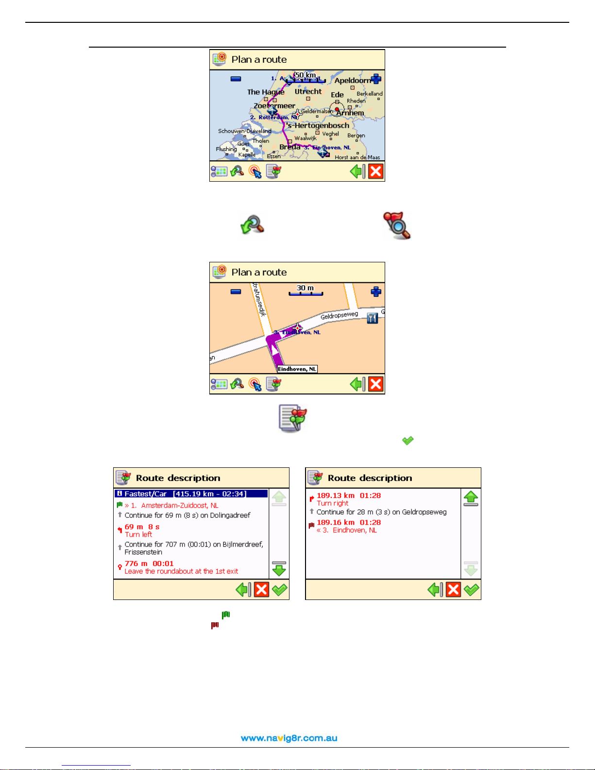
User Manual
Optionally, you can:
• Select Zoom to and then Destination to display the final
destination of your trip.
• Select Route description to display a list with all driving instructions of
the route you planned. Select a turn arrow and confirm it
the map.
to show that turn on
• The green flag represents the departure.
• The red flag represents the destination.
That’s all! Now you can start navigating to your destination.
Customize your navigation
Use the many customisation options to adapt the device to your own personal preferences.
Read the following sections and take advantage of the powerful settings in your Navig8r.
44
Sound on / Sound off
User Manual
n Go to Main Menu
.
o Choose Sound on
navigate. Choose Sound off
if you want to listen to the voice instructions while you
if you want to turn off the voice instructions.
For safety reasons, we recommend you to keep the sound switched on and listen to the voice
instructions! This way, you can concentrate on the road ahead of you and avoid any unpleasant
driving situations!
Map options
Day colours / Night colours
n In Main Menu
o Choose Day colours
, select Map options .
when navigating during the day (the device screen is
brighter).
Choose Night colours
when navigating during the night (the device screen is less
intense).
45
2D perspective / 3D perspective
User Manual
n In Main Menu
, select Map options .
o Choose 2D perspective
to view the map from above, as you look at a printed
map.
Choose 3D perspective
to have a panoramic view, as you are actually seeing the
road ahead of you.
46

Set 3D angle
User Manual
n In Main Menu
, select Map options .
o Select Set 3D angle
.
p Select and hold the slider. Drag it to the left (3D) to increase the viewing angle. Drag it
to the right (2D) to decrease the viewing angle.
q Confirm your choice .
You can use the Set 3D angle option only when the 3D perspective option is also selected!
Show favourites / Hide favourites
n In Main Menu
, select Map options .
o Choose Show favourites
Hide favourites
to remove your favourites from the map.
to show your personal favourites on the map. Choose
For example, if you have the following list of favourites:
then you can show the favourites on the map or remove them from the map:
47

User Manual
Show scale / Hide scale
n In Main Menu
o Select Show scale
When you zoom in
accordingly.
, select Map options .
to display the scale of the map at the top of the screen.
or zoom out , the distance value above the scale is updated
Select Hide scale
The scale is available only in 2D perspective!
to remove the scale.
48
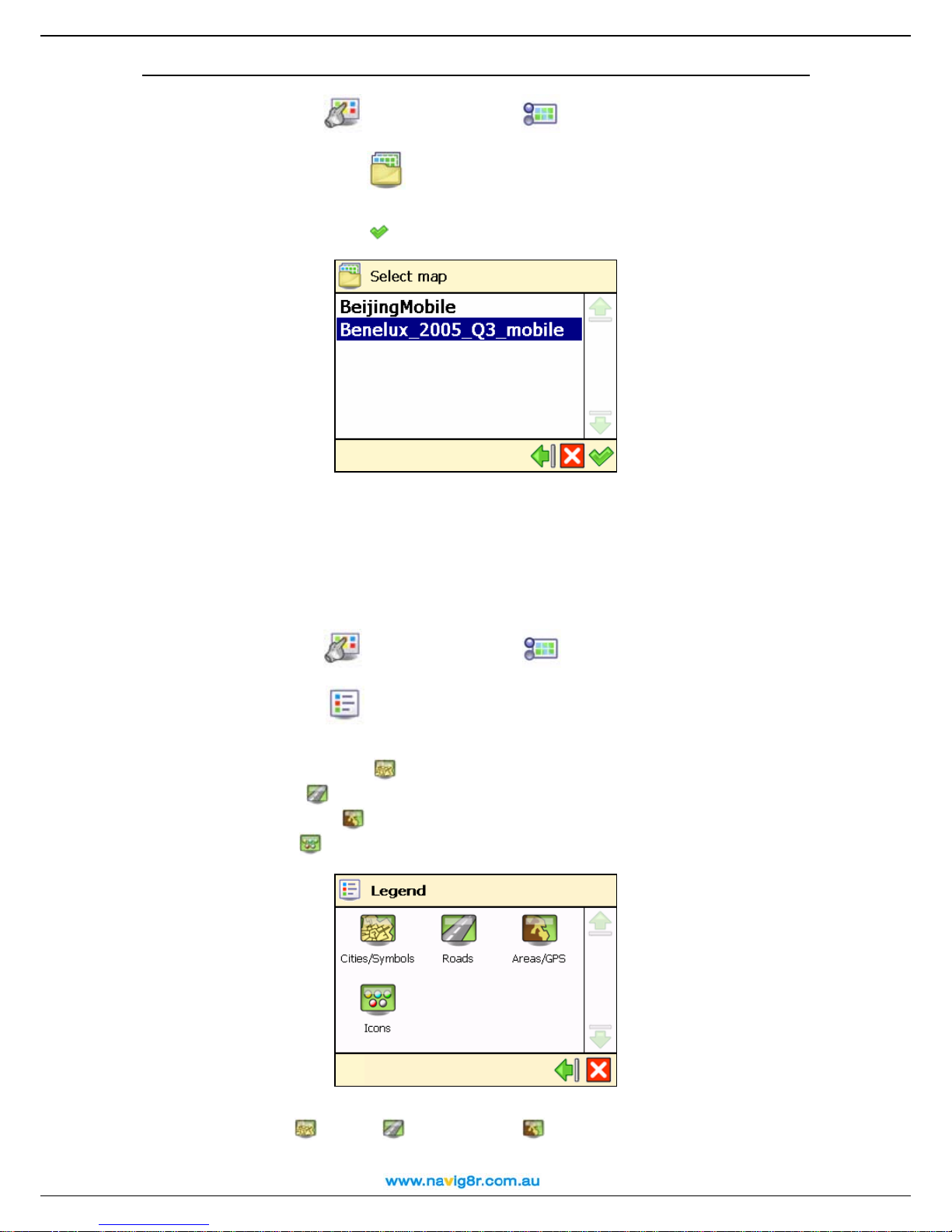
Select map
User Manual
n In Main Menu
, select Map options .
o Choose Select map
.
p The list of available maps is displayed, with the active map highlighted. Select a map
and confirm your choice
.
The memory card included in this product is preloaded with the map of the Australia.
When you select another map, only the POI categories and points-of-interest that belong to
that map are available!
Before you can use a map, first you must activate it!
Legend
n In Main Menu
, select Map options .
o Select Legend
.
p In the Legend screen, select:
• Cities/Symbols
• Roads
for different types of roads.
• Areas/GPS
• Icons
for points-of-interest.
for cities and road numbers.
for areas and arrows.
q You can change the default colours for Cities/Symbols, Roads and Areas/GPS. Select
Cities/Symbols
, Roads or Areas/GPS and select an item from the list. In the
Choose colour screen, combine the shades of red, green and blue to compose your
49

User Manual
favourite colour. Move the slider either to the left or to the right. Optionally, select Default
to return to the default colours. Confirm your changes
. From now on, your Navig8r will use
your new colours.
Points-of-interest (POI)
n In Main Menu
, select Map options .
o Choose Points-of-interest (POI)
.
p A list with all POI categories is displayed. Select those POI categories whose
points-of-interest you want to display on the map. Deselect those POI categories whose
points-of-interest you do not want to display on the map. Select the filter if necessary.
q Confirm your choice
Zoom to
To see a particular location on the map and the points-of-interest around this location, you can
browse the map by zooming in and out. Zoom in to see more details, zoom out to cover a larger
area, or drag the map in the desired direction. Or, you can simply specify a location and your
Navig8r displays it on the map. Then, start your trip to that particular location!
n In Main Menu
o Decide which location to display on the map. For details about finding locations, read
the Working with locations chapter.
p The Zoom to screen is displayed.
.
, select Zoom to .
50

User Manual
• Select Map options to change your navigation preferences.
• Select Zoom to to open the Zoom to screen.
• Select Navigate to to start navigating to the selected location.
Change settings
Backlight
n In Main Menu
o Choose Backlight
p Move the slider to the left (Min) to
decrease the brightness of the navigation
screen. Move the slider to the right (Max)
to increase the brightness of the
navigation screen.
, select Change settings .
.
p When the During navigation option is
selected, the screen is illuminated if you are
navigating to a particular destination.
When the During navigation option is
unselected, the device is illuminated for a few
seconds; then, the device enters into the power
saving mode and the screen turns off.
q Confirm your choice
.
51
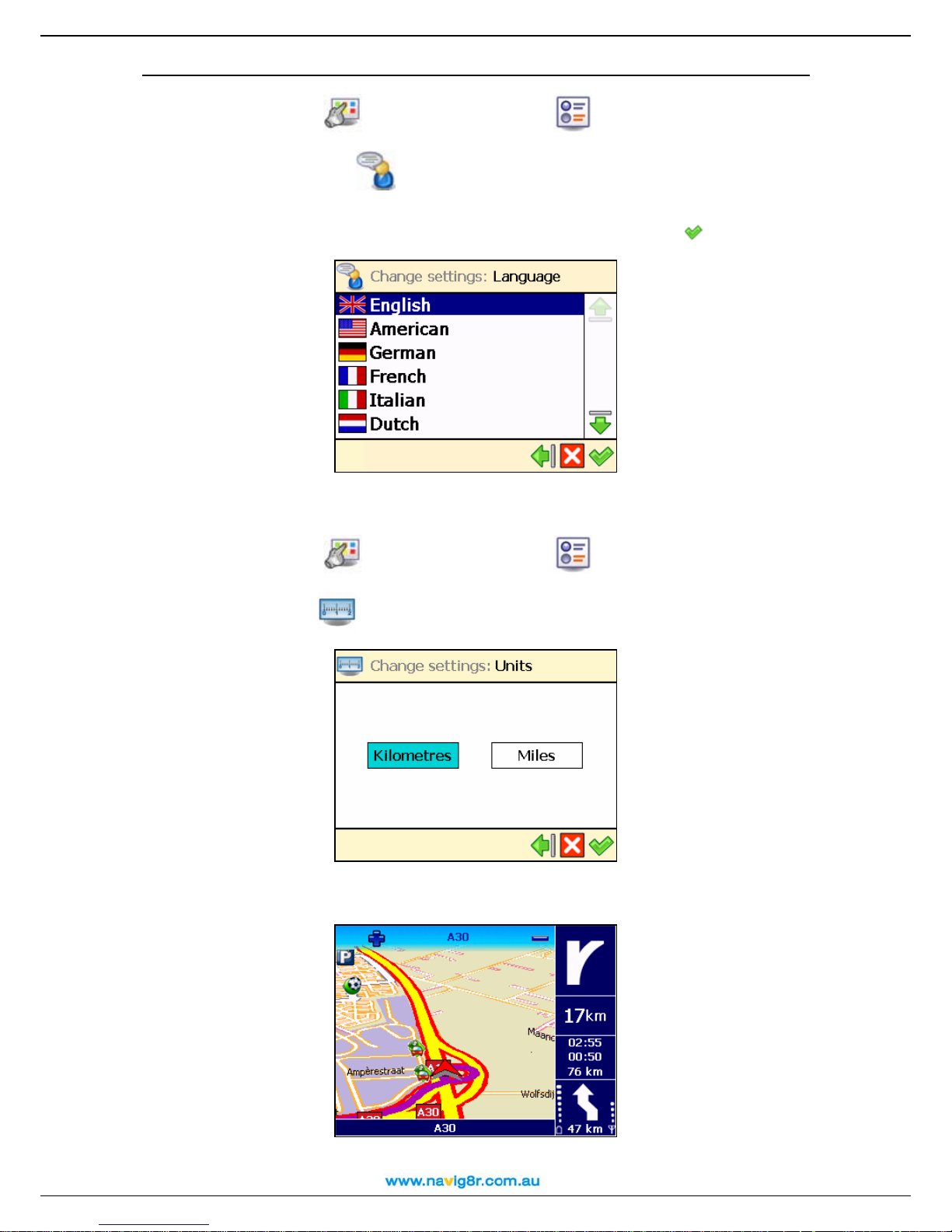
Language
User Manual
n In Main Menu
, select Change settings .
o Choose Language
.
p A list of available languages is shown. These are the languages for the user interface
and the voice instructions. Select a language and confirm your choice
.
The number of available languages depends on the product that you have bought!
Units
n In Main Menu
, select Change settings .
o Choose Units
.
p Select Kilometres if you want to display the distance information in metric units
(kilometres and metres):
52

Select Miles if you want to display the distance information in imperial units (miles and
yards):
User Manual
Volum e
n In Main Menu
o Choose Volume
p Select & hold and drag the slider to the left (Min) to lower the volume of the voice
instructions. Select & hold and drag the slider to the right (Max) to increase the volume of
the voice instructions.
q Confirm your choice .
For safety reasons, we recommend you to keep the sound switched on and listen to the voice
instructions! This way, you can concentrate on the road ahead of you and avoid any unpleasant
driving situations!
Route type
, select Change settings .
.
n In Main Menu
o Choose Route type
p Select the type of route that best reflects your navigation style:
• Fastest/Car – navigate to your destination, by car, along the fastest route.
• Shortest/Car - navigate to your destination, by car, along the shortest route.
• Fastest/Lorry - navigate to your destination, by lorry (truck), along the fastest
route.
• Shortest/Lorry - navigate to your destination, by lorry (truck), along the shortest
route.
, select Change settings .
.
53

User Manual
• Pedestrian - walk to your destination.
q Confirm your choice
Avoid motorways
n In Main Menu
o Choose Avoid motorways
p Select On if you want to exclude motorways from your route. Select Off if you do not
want to exclude motorways from your route.
Avoid toll roads
n In Main Menu
o Choose Avoid toll roads
p Select On if you want to exclude toll roads from your route. Select Off if you do not want
to exclude toll roads from your route.
Avoid ferries
.
, select Change settings .
.
, select Change settings .
.
n In Main Menu
o Choose Avoid ferries
p Select On if you want to exclude ferries from your route. Select Off if you do not want to
exclude ferries from your route.
, select Change settings .
.
54

Automatic zooming
User Manual
n In Main Menu
, select Change settings .
o Choose Automatic zooming
.
p Select On if you want to automatically enlarge the map (zoom in) and see more details
of the road when approaching street junctions.
Select Off if you want to manually select the zoom level you need; the zoom level you
selected is preserved until you manually change it.
55

Configure alarm
Never underestimate the safety measures! Use this option to set a safety speed: when you
navigate and reach this speed, an alarm warns you that you are driving too fast.
User Manual
n In Main Menu
o Choose Configure alarm
p Select the numeric value (for example, 140). In the Alarm speed screen, type a
different value and confirm your choice
, select Change settings .
.
.
q In the Alarm type section, select the left arrow
type of warning that automatically starts when you drive too fast:
or the right arrow to select the
• None – no warning
• Acoustic alarm – a sound warning
• Visible alarm – a blinking warning
• Both - a sound warning and a blinking warning
r Confirm your choice
.
56

User Manual
Speed
Feel free to further customize your navigation! You can indicate the speed you prefer for each
type of road. These values will be considered when calculating a route, the estimated travel time
and the estimated time of arrival. Please note that if you change the speed setting, the calculated
routes will be different.
n In Main Menu
, select Change settings .
o Choose Speed
.
p Select a type of road (for example Motorway). Select the numeric value (for example
100). In the Alarm speed screen, type a different value and confirm your choice
.
q When you configured all speed values, confirm them
Set date/time
You can modify the date and time displayed by your Navig8r.
n In Main Menu
, select Change settings .
o Choose Set date/time
.
.
57

User Manual
p The first three controls represent the date (year-month-day). The last two controls
represent the time (hour-minutes). Use the up arrow
or the down arrow to select
the correct values.
q Use the back arrow
or the next arrow to select your time zone.
r Select Synchronize with GPS receiver to set the date and time, based on the
selected time zone and the available GPS information.
s Confirm your choice
.
Set Time/Date may only display Time zone selection option. This is normal for some versions!
Vertical turn arrows / Horizontal turn arrows
Would you prefer to see the driving instructions (turn arrows) on the right side of the navigation
screen, or at the bottom of the navigation screen? Choose the option you prefer.
n In Main Menu
, select Change settings .
o Choose Vertical turn arrows
to display the driving instructions on the right
side of the screen.
Choose Horizontal turn arrows
of the screen.
to display the driving instructions at the bottom
58

User Manual
This option is available only for certain devices!
Calibrate screen
To be sure that the screen of your device works properly, you must calibrate your screen when
necessary. Calibrating means adjusting the precision and reaction of the screen.
n In Main Menu
, select Change settings .
o Choose Calibrate screen
.
p Select & hold your stylus on the cross icon +. You must select the screen 5 times: first
in the centre, then in the 4 corners of the screen.
q Select the screen again to save your settings.
Define your navigation experience
Points-of-interest (POI)
Well, you travelled a lot and saw many wonderful places. Now it’s the right moment to organize
the locations you visited during your trips. Define your personal categories of points-of-interest.
Add locations to your POI categories. Set advanced warnings.
Maintain POI
Add, rename or remove points-of-interest.
Add as POI
n In Main Menu
o Choose Maintain POI
p Choose Add as POI
, select Points-of-interest (POI) .
.
.
59

User Manual
q Select a user-defined POI category and confirm your choice
. Any POI must belong
to a POI category.
You cannot continue if there isn’t at least one user-defined POI category!
r Decide how to find the POI you want to add. For details about finding locations, read the
Working with locations chapter. Confirm
to save the selected location as a POI to
the current category.
Rename POI
n In Main Menu
o Choose Maintain POI
p Choose Rename POI
q Select a user-defined POI category and confirm your choice
, select Points-of-interest (POI) .
.
.
.
r Select the point-of-interest you want to rename, then confirm your choice
s Change the name of the selected POI.
.
60
User Manual
t Confirm your choice
Remove POI
n In Main Menu
o Choose Maintain POI
p Choose Remove POI
q Select a user-defined POI category and confirm your choice
r Select the point-of-interest you want to delete, then confirm your choice
.
, select Points-of-interest (POI) .
.
.
.
.
s Select Yes to confirm that you really want to delete this POI.
61

User Manual
Maintain POI category
Add, rename or remove POI categories.
Keep in mind that there are two kinds of POI categories:
pre-installed categories – These POI categories belong to the geographic map. You
cannot modify or remove them.
user-defined categories – You can add and modify these POI categories.
Add POI category
n In Main Menu
o Choose Maintain POI category
p Choose Add POI category
q Type the name of the new category, for example Hotel (nl). Confirm your choice
, select Points-of-interest (POI) .
.
.
.
r Select a relevant icon for the new POI category, and confirm your choice
.
62

Rename POI category
User Manual
n In Main Menu
, select Points-of-interest (POI) .
o Choose Maintain POI category
.
p Choose Rename POI category
.
q Select a user-defined POI category and confirm your choice
.
r Change the name of the selected POI category and confirm your choice .
63
Remove POI category
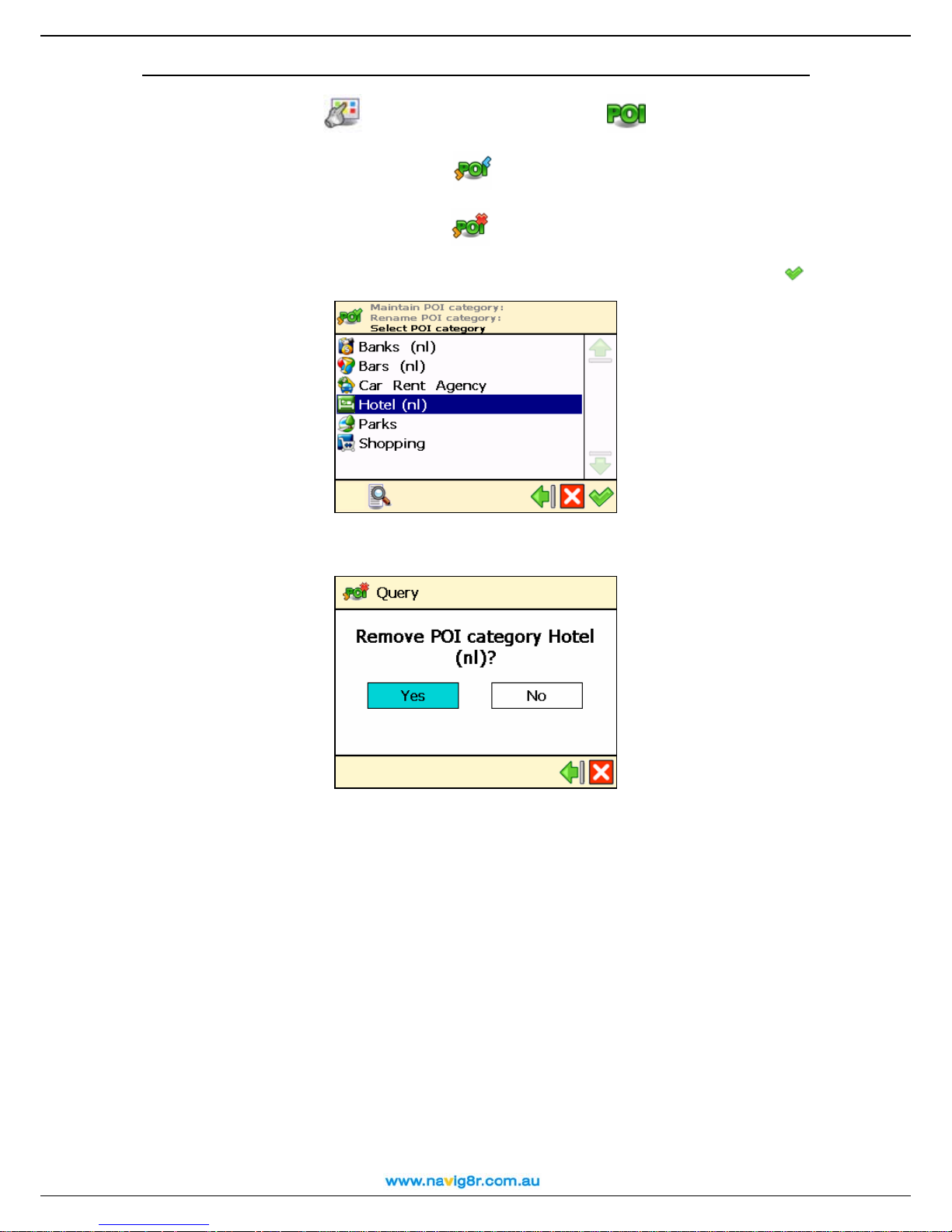
User Manual
n In Main Menu
, select Points-of-interest (POI) .
o Choose Maintain POI category
.
p Choose Remove POI category
.
q Select the user-defined POI category you want to delete, then confirm your choice
r Select Yes to confirm that you really want to delete this POI category.
.
When you delete a POI category, all points-of-interest belonging to that category are also
deleted!
64

POI alarm
You are on holiday. You are driving to your holiday destination. Wouldn’t it be nice to know, in
advance, that a gas station or a hotel is 1 km ahead of you, along your route? Activate your POI
alarm! You will never miss an important location.
User Manual
n In Main Menu
o Choose POI alarm
p Select a POI category and confirm your choice
you will be warned in advance that you are approaching points-of-interest from this POI
category along your route. For example, select the POI category Museum; this means
that you will be warned when you are approaching a museum. Each category has its own
icon, for example
, select Points-of-interest (POI) .
.
. This means that, during navigation,
for Hospital, for Library or for Museum.
means a POI category previously configured for POI alarm.
means a POI category you have just selected for POI alarm.
means a POI category that is currently ignored by the POI alarm.
You can select and configure several categories at the same time! The same warning type,
warning distance and warning sound will be applied to all categories you selected!
q Select the type of warning you prefer and confirm your choice
Icons and distance
in top left corner
Icons and distance
in top right corner
Icons and distance
:
at GPS location
r Select at which distance from the point-of-interest you want to receive a warning and
confirm your choice
.
65
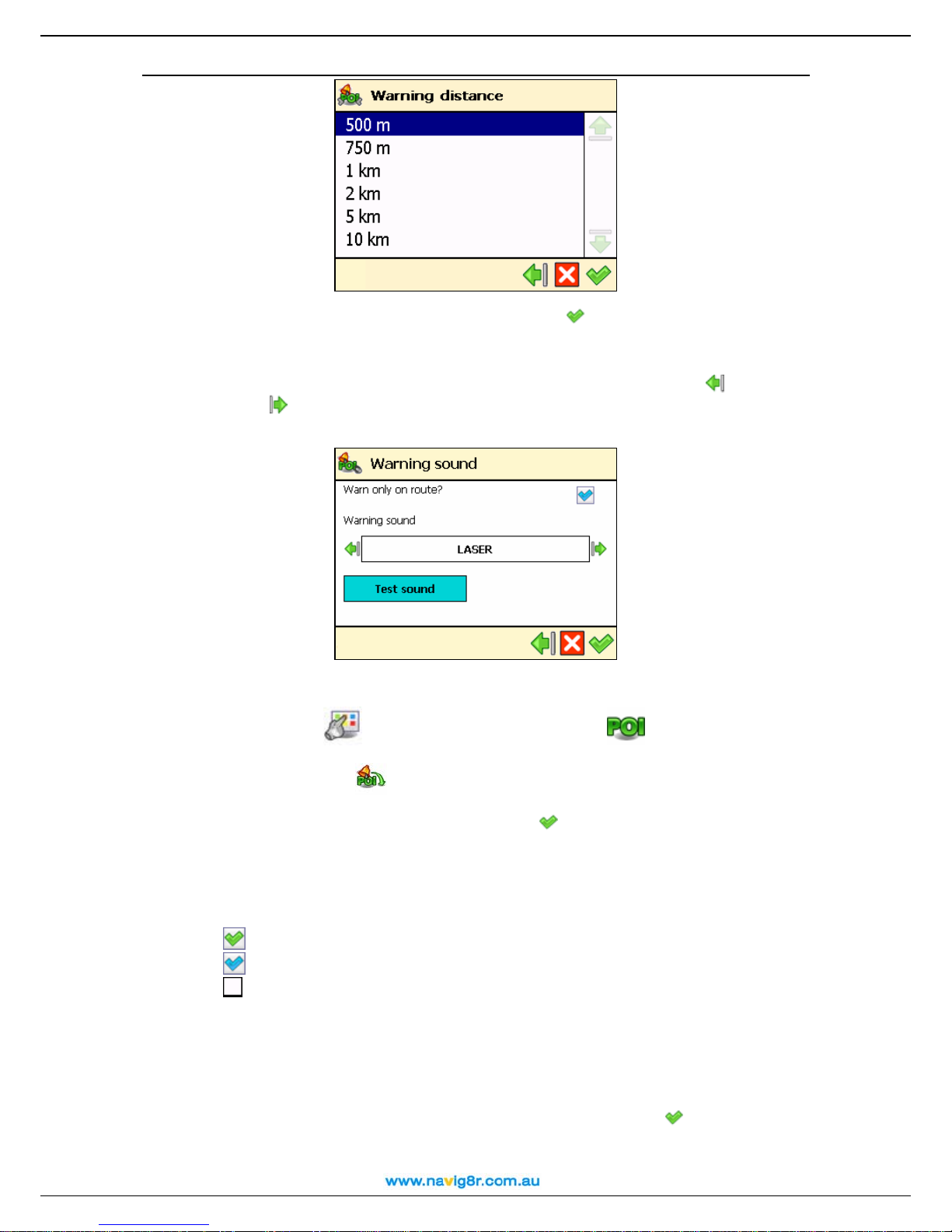
User Manual
s Select the warning sound and confirm your choice
Warn only on route? – When selected, you will be warned only about
points-of-interest along your route; when deselected, you will be warned about any
points-of-interest along and around the route.
Warni ng sound – Select a sound that you like. Select the left arrow or the right
arrow
to scroll the list of available sounds.
Tes t sou n d – Select and listen to the selected sound.
Speed and Red Light Camera alarm
:
n In Main Menu
o Choose POI alarm
p Select a POI category and confirm your choice
you will be warned in advance that you are approaching points-of-interest from this POI
category along your route. For example, select the POI category Speed or Redlight;
this means that you will be warned when you are approaching a Fixed Speed Camera or
Red Light Camera.
, select Points-of-interest (POI) .
.
. This means that, during navigation,
means a POI category previously configured for POI alarm.
means a POI category you have just selected for POI alarm.
means a POI category that is currently ignored by the POI alarm.
You can select and configure several categories at the same time! The same warning type,
warning distance and warning sound will be applied to all categories you selected!
Speed and Red Light cameras are being added to the roads all the time. Some safety cameras
may not be listed in the data base. Please drive carefully!
q Select the type of warning you prefer and confirm your choice
ALARM for information on ICON warning location selection.
r Select at which distance from the point-of-interest you want to receive a warning and
: (Please see POI
66

confirm your choice
.
User Manual
s Select the warning sound and confirm your choice
:
Warn only on route? – When selected, you will be warned only about
points-of-interest along your route; when deselected, you will be warned about any
points-of-interest along and around the route.
Warni ng sound – Select a sound that you like. Select the left arrow or the right
arrow
to scroll the list of available sounds.
Tes t sou n d – Select and listen to the selected sound.
Favourites
There are many locations that you visit frequently and are of great importance to you. Save
these locations as your favourites – one time only! Add these favourites to your trips – over and
over again!
Use the Favourites menu to set your home address and your office address. You can also add
favourites, rename favourites and remove favourites.
Set home address
n In Main Menu
o Choose Set home address
p Type the name of the location you want to find and confirm your choice
, select Favourites .
.
.
67

User Manual
q In the list of results, select the address that you want to add as your home address.
Select the filter if necessary. Confirm your choice
to continue.
r A summary report is displayed. Select
to finish.
Set office address
n In Main Menu
o Choose Set office address
p Type the name of the location you want to find and confirm your choice
, select Favourites .
.
.
68

User Manual
q In the list of results, select the address that you want to add as your office address.
Select the filter if necessary. Confirm your choice
to continue.
r A summary report is displayed. Select
to finish.
Add favourite
n In Main Menu
o Choose Add favourite
p Decide how to find the favourite you want to add. For details about finding locations,
read the Working with locations chapter.
, select Favourites .
.
69

User Manual
q Select
to save the selected location as a favourite location.
Rename favourites
n In Main Menu
o Choose Rename favourites
p Select the favourite destination you want to rename and confirm your choice
q Change the name of the selected favourite and confirm your choice
, select Favourites .
.
.
.
70

Remove favourites
User Manual
n In Main Menu
, select Favourites .
o Choose Remove favourites
.
p In the list of results:
• Select Delete
• Select Delete all
to delete the selected favourite;
to delete all favourites.
q Select Yes to confirm that you really want to delete this favourite.
71

User Manual
Appendix
Installing other geographic map(s) and voice instructions on the Memory Card
You can (re)install the navigation software, geographic map(s) and voice instructions from the
enclosed back-up CD(s) onto your memory card.
When you use the installation CD(s) for the first time, you first have to manually format your
memory card (see Formatting your Memory Card below for how to do this). If you have
completed an earlier installation using the CD(s), you can immediately proceed with the steps
below.
1. Connect the memory card reader & writer to the USB port of your computer, then insert
the memory card into the memory card reader & writer and the CD into the CD drive.
2. The installation should start automatically. If it does not start, please run setup.exe from
the CD(s).
3. Select the language you want the installation to be performed in, e.g., "English", and click
Next.
4. Click Next to continue.
5. Select the drive where the files should be installed. Click Next to continue.
6. Read the license agreement carefully, select the first option and click Next to continue.
If geographic map(s) and voice instructions are already installed on your memory card,
choose the relevant option and click Next to continue:
Modify to select new components to install or the components to remove (see steps
7 to 10 below).
Repair to reinstall the components that were previously installed (see steps 7 to 10
below).
Remove to remove the installed components (see step 10 below).
7. Select the language of the voice instructions (e.g., "English") you want to install onto the
memory card. Note: The default language is identical to the Setup Language. Click Next
to continue.
8. Select the geographic map(s) you want to install onto the memory card (e.g., "United
Kingdom & Ireland"). Click Next to continue.
9.
Click Install to start installing the geographic map(s) and the voice instructions onto the
memory card. (For products with more than one CD: please note that not all CDs are
necessarily asked for during the installation process. This depends on which map(s) you
have selected for installation in step 8).
10. Click Finish to complete the installation / maintenance process. The geographic map(s)
and voice instructions are now installed on your memory card and can be used for
navigation.
72

User Manual
Formatting your Memory Card
Formatting the memory card maximizes the free space on the memory card and optimizes the
speed of reading and writing files from/onto the memory card.
Warning:
Formatting will erase ALL data on the memory card. Note that your Navig8r can always be
restored on your memory card using the CD(s), but you may want to backup other data (e.g.,
photographs or MP3s) that you have stored on the memory card.
1. Insert your memory card into the memory card reader & writer.
2. Connect your memory card reader & writer to a USB port of your PC.
3. Open (double-click) My Computer on your PC. The corresponding memory card
appears in the Devices with Removable Storage section as “Removable Disk”. Make
sure this is the correct memory card (e.g., disconnect the memory card reader & writer
and verify that the disk disappears from the list; next, reconnect your memory card reader
& writer).
4. Click on the right button of the mouse on the identified Removable Disk and choose
"Format..." Select “FAT” (not “FAT32”) under "File system" and click Start. Take good
notice of the contents of the warning message. If you agree, click OK. The memory card
will be formatted, erasing ALL data on it!
5. The “Format Complete” dialog appears after 10 seconds. Click OK, then click Close.
73

User Manual
How does GPS work?
The Global Positioning System (GPS) is a satellite-based navigation system made up of a network
of 24 satellites placed into Earth’s orbit. GPS works in any weather condition, anywhere in the
world, 24 hours a day. There are no subscription fees or setup charges to use GPS.
A GPS receiver must be locked on to the signal of at least three satellites to calculate a 2D position
(latitude and longitude) and track movement. With four or more satellites in view, the receiver can
determine your 3D position (latitude, longitude and altitude).
74

User Manual
Quick Reference Card – Navigate to a location
Use this printable Quick Reference Card to easily find the steps to follow in order to navigate
to a location.
Navigate to your home
address
Find an address and navigate
to it
Navigate to a favourite
location
n In Main Menu
Navigate to
, select
.
o Select Home
.
Navigate to your office
address
n In Main Menu
Navigate to
, select
.
o Select Office
.
Navigate to a recently visited
location (History)
n In Main Menu
Navigate to
, select
.
o Select Locations
.
p Type the name of the city. When
you have entered all search
strings, confirm them
.
q Wait for a few seconds. When
the list of results is displayed, pick
out the location that you are
looking for. Confirm your choice
.
Navigate to a contact
n In Main Menu
Navigate to
, select
.
o Select Favourites
.
p The list of locations you have
saved before as favourites is now
displayed on the screen. Select
the location you need and confirm
your choice
.
Navigate to a POI around your
GPS position
n In Main Menu
Navigate to
, select
.
o Select History
.
p The list with the locations you
have visited recently is now
displayed on the screen. Select an
item in the list and confirm your
choice
.
n In Main Menu
Navigate to
, select
.
o Select Contacts
.
p From the list of available
contacts, select the contact you
need and confirm your choice
.
q From the list of available
addresses, select the location you
need and confirm your choice
.
n In Main Menu
Navigate to
, select
.
o Select POI around GPS
position
.
p Select a relevant POI category
and confirm your choice
.
q Select an item from the list and
confirm your choice
.
75
Navigate to a POI around your
destination
User Manual
Find a point on the map and
navigate to it
Navigate to a destination via
intermediate points (Navigate
via)
n In Main Menu
Navigate to
, select
.
o Select POI around
destination
.
p Select a relevant POI category
and confirm your choice
.
q Select an item from the list and
confirm your choice
.
Plan a route
n In Main Menu
Plan a route
, select
.
o Add your departure location.
p Add your first destination
location.
q Select Yes and go to step r if
you want to add other locations as
additional stopovers to your trip.
Select No and go to step s to
display the map and the departure
location.
rIn the Destination screen,
select the second destination for
your trip
s The route is calculated. The
entire route is shown on the map.
n In Main Menu
Navigate to
.
, select
n In Main Menu
Navigate via
.
o Select Point on map
.
p The map and your current
position are displayed. Select &
hold and drag the map in the
desired direction. When you see
on the map the location of your
memories, select on it. The
pointer
indicates this location
on the map.
o Select a single waypoint and
then confirm your choice
p Select Yes and go to step q if
you want to add other locations as
additional stopovers to your trip.
Select No to start navigating.
q In Add waypoint, select
another location for your trip.
When you added all waypoints,
confirm them
and then select
No.
q Select Navigate to
to
add this location as your
destination.
Tips
• When entering an address, try not using road types in the search
string you enter; For Example if you are looking for “123 smith
street, Smithville”, try entering “123 Smith” and then
to confirm
your choice.
• When presented with the search findings use the
filter to refine
your search.
• Some streets are said to be in one suburb but can be officially
recorded in another. Please check streets with the same name in
surrounding suburbs of your destination if not shown on your first
search.
• Check the spelling to ensure that the name is correct.
, select
.
Select Navigate to
start travelling along the route you
planned.
to
76

User Manual
Customer Support
If you have any questions regarding the use of your Navig8r, please send an e-mail to
support@laserco.com.au. You can also visit the Navig8r web site
(http://www.Nvaig8r.com.au) from time to time in order to stay informed about updates.
To report map errors please visit http://www.navteq.com and use the map reporter link.
Disclaimer
1. Location measurement with a GPS receiver should not be used for precise location
measurement. Therefore you should never rely solely on the location measurement
by the GPS receiver.
2. All digital cartography is to a certain degree inaccurate and incomplete. Therefore
you should never rely solely on the cartography provided by this product.
3. You agree that the personal data you provide by using this product may be used to
provide the services of this product to you and that these personal data may be
transferred outside Australia.
4. Points Of Interest (POI) data are supplied as is. Laser Corporation cannot guaranty
the accuracy of any data contained in the POIs. This includes Speed and Red Light
Cameras. It is the drivers responsibility to ensure that they are driving within the law at
all times.
5. When you are using hardware and software navigation aids like this
product in a vehicle, it is your sole responsibility to place, secure, and
use these aids in such a manner that they will not cause accidents,
personal injury or property damage, or in any manner obstruct your view.
You, the user of this product, are solely responsible for observing safe
driving practices at all time. While driving keep your hands on the wheel
and your eyes on the road. Do not manipulate this product while driving
but park the vehicle first. LASER CORPORATION AND ITS
SUPPLIERS HEREBY DISCLAIM ALL LIABILITY FOR ANY USE OF
THIS PRODUCT IN A WAY THAT MAY CAUSE ACCIDENTS,
DAMAGE OR VIOLATION OF THE LAW.
77
 Loading...