


1
TABLE OF CONTENTS
Table of Contents
IMPORTANT NOTICES AND WARNINGS ................................................................................... 4
This Documentation ........................................................................................................................................ 4
Global Positioning System ............................................................................................................................... 4
Precautions ..................................................................................................................................................... 4
WHAT’S IN THE BOX ....................................................................................................................... 5
1. GETTING TO KNOW YOUR NAVIG8R GPS ........................................................................ 5
1.1 Warning .................................................................................................................................................... 6
1.2 Before Using Your Navig8r GPS Unit .......................................................................................................... 6
1.3 Mounting the GPS Unit in Your Vehicle ..................................................................................................... 7
1.4 Connecting the Car Charger ....................................................................................................................... 7
NAVIGATION ...................................................................................................................................... 8
Before Using the Navig8r Please Read the Following ...................................................................................... 9
Key Features ................................................................................................................................................... 9
2. Getting Started With Your Navig8r GPS System......................................................................................... 10
2.1 Start Up Screen: The Navigation Menu ...................................................................................................... 12
2.2 Buttons and Other Controls on the Screen................................................................................................. 13
2.2.1 Using Keyboards ...................................................................................................................................... 14
2.3 Map Screen ................................................................................................................................................. 15
2.3.1 Navigating On The Map ........................................................................................................................... 15
2.3.2 Status Information and Hidden Controls on the Map. ............................................................................ 18
2.3.3 Variable Data fields. ................................................................................................................................. 19
3 Navigation Menu ........................................................................................................................................ 20
3.1 Setting a Destination .................................................................................................................................. 20
3.1.1 Finding an Address................................................................................................................................... 20
3.1.2 Entering a State ....................................................................................................................................... 21
3.1.3 Entering a Suburb .................................................................................................................................... 21
3.1.4 Entering a Street ...................................................................................................................................... 22
3.1.5 Entering a Street Number ........................................................................................................................ 22
3.1.6 Finalising the Destination ........................................................................................................................ 22
3.1.6.1 Destination Options .............................................................................................................................. 23
3.1.6.2 Further Destination Options ................................................................................................................. 23
3.2 Finding a POI ............................................................................................................................................... 24
3.2 Destination History ..................................................................................................................................... 25
3.2 Find GPS Coordinate ................................................................................................................................... 25
3.3 Find Favourite ............................................................................................................................................. 25

2
4 Manage Menu ............................................................................................................................................... 26
4.1 Manage Menu Explained ............................................................................................................................ 26
4.1.1 Manage Menu Controls ........................................................................................................................... 27
4 Route Menu ............................................................................................................................................... 28
4.1 Route Menu Explained ............................................................................................................................... 28
5 Settings Menu ............................................................................................................................................ 29
5.1 Route Menu Explained ............................................................................................................................... 29
6 GLOSSARY .................................................................................................................................... 31
2D/3D GPS reception .................................................................................................................................... 31
Active Route.................................................................................................................................................. 31
City Centre .................................................................................................................................................... 31
Colour Theme ................................................................................................................................................ 31
GPS Accuracy ................................................................................................................................................ 31
Map .............................................................................................................................................................. 31
North-Up Map Orientation............................................................................................................................ 32
Road Safety Camera ...................................................................................................................................... 32
Route ............................................................................................................................................................ 32
Track-Up Map Orientation ............................................................................................................................ 32
Vehimarker ................................................................................................................................................... 32
HARDWARE .................................................................................................................................... 33
7 MAIN SYSTEM MENU ................................................................................................................ 34
7.1 GPS .......................................................................................................................................................... 35
7.2 SYSTEM ................................................................................................................................................... 35
7.2.1 Language .................................................................................................................................................. 36
7.2.2 Backlight .................................................................................................................................................. 36
7.2.3 Power ....................................................................................................................................................... 36
7.2.4 Sound ....................................................................................................................................................... 37
7.2.5 Time ......................................................................................................................................................... 37
7.2.6 Sound ....................................................................................................................................................... 38
7.2.7 System ..................................................................................................................................................... 38
7.3 Tools........................................................................................................................................................ 39
7.3.1 Calculator ................................................................................................................................................. 39
7.3.2 Picture Viewer ......................................................................................................................................... 39
7.4 GPS Test .................................................................................................................................................. 40

3
8 CHARGING THE NAVIG8R ....................................................................................................... 41
8 CONNECTING TO A PC .............................................................................................................. 41
10 FRESH MAP GUARANTEE ..................................................................................................... 41
11 TECHNICAL SPECIFICATIONS ............................................................................................. 41
Disclaimer: .................................................................................................................................................... 41
12 FREQUENTLY ASKED QUESTIONS ..................................................................................... 42
13 END USER LICENCE AGREEMENT (EULA) ....................................................................... 47
14 COPYRIGHT NOTE................................................................................................................... 51
15 WARRANTY AGAINST DEFECTS ......................................................................................... 52

4
IMPORTANT NOTICES AND WARNINGS
Important Notices and Warnings
This Documentation
Thank you for choosing our product as your navigator. Read the Quick Start Guide first and start
using your device right away. This document is the detailed description of the navigation software
and hardware. You can easily discover the software while you are using it; however, we still
recommend that you read this manual to fully understand the screens and features.
Global Positioning System
The Global Position System (GPS) is a satellite-based system that provides location and timing
information around the globe.
GPS is operated and controlled under the sole responsibility of the Government of the United States
of America, who are responsible for its availability and accuracy. Any changes in GPS availability and
accuracy or in environmental conditions, may affect the operation of your Navig8r. We cannot
accept any liability for the availability or accuracy of GPS.
Precautions
For your safety and the safety of other road users, do not operate the controls of this Navig8r while
driving. Use care when operating the Navig8r. This product is intended to be used only as an aid to
navigate. It is not intended for the precise measurement of direction, distance, or location
topography.
The Calculated routes are for reference only. It is the user’s responsibility to follow all local traffic
regulations and traffic signs when driving. Local conditions and regulations may change at short
notice and may not be included in the software/mapping data of this product.
When leaving your vehicle, do not leave the Navig8r on the dashboard of the car. It should be
removed and placed in a secure place along with the windscreen mount and power cable. Do not
leave the Navig8r in direct sunlight or in an enclosed vehicle when not in use. Overheating of the
battery may cause damage or cause the Navig8r to malfunction. Extreme overheating may cause
the battery to leak.
GPS satellite signals cannot pass through solid materials with the exception of glass. When travelling
through tunnels or inside buildings, such as parking stations, GPS positioning is not available. The
time taken for the Navig8r to re-acquire satellite signals when emerging from tunnels or buildings
may vary and will depend on atmospheric conditions and the environment.
A minimum of four GPS satellite signals is required to determine the Navig8rs current location. Signal
reception can be affected by atmospheric conditions such as; bad weather, thick clouds, solar
activity and dense overhead objects such as trees, tall buildings and large road signs. Wireless
devices can also interfere with satellite reception.
The use of devices with a GPS antenna is prohibited on most aircraft, hospitals and other locations
that contain sensitive equipment. The Navig8r should not be used in these environments.
5
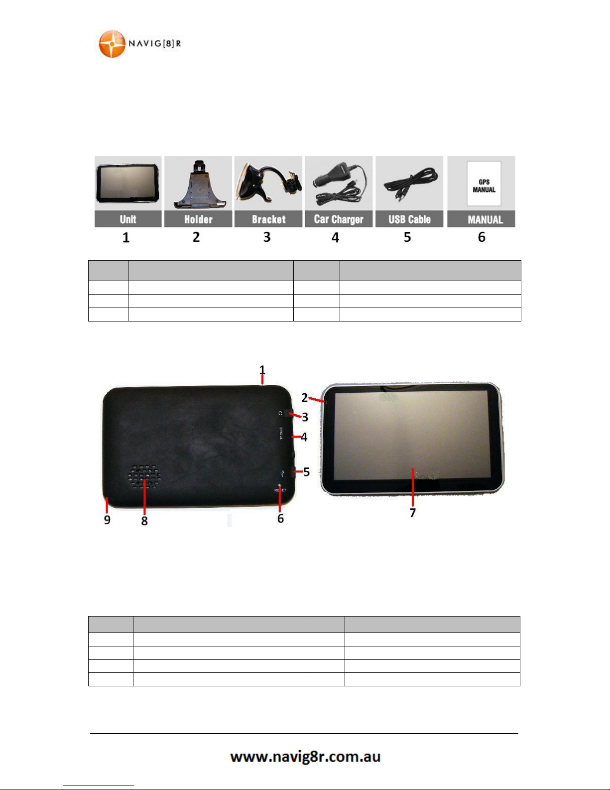
WHAT’S IN THE BOX
What’s in the Box
Unpack the box and identify the contents. You should have the following items:
*Images shown here are a representation only and may differ from actual products
ITEM DESCRIPTION ITEM DESCRIPTION
1 The Navig8r GPS unit 2 GPS device holder
3 Bracket/Windscreen Mount
4
Car Charger (12v DC)
5 USB Data Cable
6
User Manual (This Document)
1. Getting To Know Your Navig8r GPS
ITEM
DESCRIPTION
ITEM
DESCRIPTION
1
Sleep
ON/OFF Button
2 Charge Indicator Light
3 3.5mm Earphone /Audio Out
4
Micro SDHC Card slot
(Card not Supplied)
5 USB
/Charger
connectio
n 6 Reset Button
7
LCD Touch Screen
8 Speaker

6
WARNING
1.1 Warning
This Navig8r GPS should not be used in conditions of high temperature, high humidity or dusty
conditions. We recommend that the Navig8r is not left in direct sunlight for extended periods or left
fitted to the windscreen, dashboard or glove box.
Prolonged exposure to high temperatures may cause the Navig8r to malfunction and may even
cause permanent damage to the Navig8r.
There are no user serviceable parts in this device. Opening the device may cause harm and damage
the device. Any attempt to disassemble this device will void the warranty.
Images, screen shots and features shown in this manual may vary slightly from the actual product.
We reserve the right to make changes to this product without notice.
1.2 Before Using Your Navig8r GPS Unit
Please check the contents of the packaging and ensure that all equipment is located and identified.
The protective screen cover may be left on the device but may impede the viewing of the device in
normal operation.
Connect the Navig8r GPS unit to power source for a period of 24 hours in the first instance to charge
and condition the battery. It may take several charge/discharge cycles for the device to reach peak
endurance. The charging process will take longer if the device is turned on.
Subsequent charging should take less time to complete.
This GPS can only be charged from the PC USB port when the Navig8r is turned OFF.
Once the initial charge has been completed turn the GPS device on. The Navig8r should launch the
Navigation software.
To turn the device off for short periods simply remove the Navig8r from its power supply (or turn the
ignition off). If the navigation software is running the Navig8r will detect the power off and place
itself in sleep mode. When the power is turned back on again the Navig8r will start at the last screen
shown.
The GPS will continue to draw power from the battery in sleep mode and will go flat after 24 to 36
hours.
To turn the GPS off manually or if the device is not to be used for periods longer than two or three
days, simply press the power button for 3 seconds and then tap the shut down option or cancel to
return to the previous screen.
If no option is selected the Navig8r will turn off after 15 seconds.
Prior to using the GPS system for the first time, it is recommended that the touch screen be
calibrated. Please see the system setting instructions further on in this manual.

7
CONNECTING THE CAR CHARGER
1.3 Mounting the GPS Unit in Your Vehicle
Fit the windscreen mount to the holder which you have attached to the rear of the GPS unit and test
mount the GPS on the windscreen of the car. Choose a position that will not obstruct your vision
whilst driving but will also provide the GPS unit the best coverage of the sky through the windscreen.
Loosen the two knobs on the mount to allow movement of the pivot points.
The Navig8r should only be fitted on fixed windows.
Once the best location has been determined, remove the protective film from the suction cap of the
windscreen mount and, on clean glass, fit firmly against the windscreen. Push the tab located on the
top of the suction cup towards the windscreen until it locks in place. For best results it is
recommended that the suction cup be moistened before fitting.
In a normal driving position adjust the GPS to a position that will be in view whilst driving and does
not obstruct your view of the road. Once the correct position has been found tighten the two knobs
on the mount to prevent the GPS moving from vibration. Do not over tighten these knobs.
Changes in temperatures and condensation may cause the suction cup to become loose and should
be checked on a regular basis. To avoid damage or theft, the GPS should not be left on the
windscreen mount overnight.
To remove the mount from the windscreen, take hold of the mount in one hand and use the other to
pull the tab away from the mount. Locate the plastic tab on the side of the suction cup and gently
pull away from the windscreen to break the seal.
N.B: Tinted windows may impede the Navig8rs ability to detect the GPS satellites correctly.
1.4 Connecting the Car Charger
Caution: To protect the GPS against the possibility of damage caused by power surges when the
vehicle is started, the charger should not be connected to the GPS device when the vehicle is
started.
The car charger supplies power to the device when it is being used in the vehicle.
Connect the USB plug to the USB socket of the GPS and then fit the other end in to the
cigarette/power outlet of your vehicle once the vehicle has been started.
The charge light indicator on the GPS should glow when connected to power.
The GPS can now be started by pressing the power button on top of the device for about 3 seconds.
When starting the GPS in the vehicle it may take a short period of time for the system to acquire a
valid GPS signal. Please make sure that the GPS unit has a clear view of the sky and is not impeded
by trees, awnings, car ports or similar obstructions.

8
NAVIGATION
NAVIGATION

9
TABLE OF CONTENTS
Before Using the Navig8r Please Read the Following
Personal Navigation devices are designed to be an aid to navigation only. They are to be used in
conjunction with all local road rules, laws and regulations. It is the responsibility of the driver to
ensure that the vehicle is driven in a safe manner in compliance with these laws.
In most states it is illegal to operate a GPS system while driving a vehicle. When entering information
into the GPS, please pull over safely to the side of the road before using this device. It is better to set
the destination for the GPS before you start on your trip rather than trying to enter it on the move.
When positioning the GPS system on the windscreen of your vehicle, make sure that it is placed in a
position that provides a clear view of the road ahead and ensure the driver does not have to look
away from the road to check the screen.
Please read the hardware section to ensure that all accessories can be identified and you can
assemble the navig8r GPS. Also please read the section on “Mounting the GPS unit in your vehicle”
in the hardware section to ensure that the Navig8r is mounted safely and securely.
The first time the GPS unit is used, or it has not been used for some time, it may take some several
minutes for it to detect the GPS satellites. Restarting the system in the same location should acquire
the signals quickly.
Please read this section carefully.
Key Features
Speed limits and over speed warnings On Major Roads and motorways.*
Intuitive menus.
Huge array of POI (Points Of Interest) data
Simple to use.
*Data included in this software is for guidance only and is only provided as an indicator and does
not cover work works. Not all roads or areas are covered. It is the responsibility to drive with in the
posted speed limit.
**Warnings are provided as an aid to driving only. The data provided in the device may not cover
all points. Please drive according to the conditions and take note of any posted warning signs.
All images and text in this manual is indicative only. Features and actions on the actual product
may vary. We reserve the right to change the product without notice.
10
GETTING STARTED WITH YOUR NAVIG8R GPS SYSTEM
2. Getting Started With Your Navig8r GPS System
Mount and connect the Navig8r as described in this manual. Press the power button on the top of
the Navig8r. The Navigation software will run automatically.
The software is optimised for in-car or pedestrian use. There is no need to use a stylus. You can use
it easily by tapping the screen buttons and the map with your fingertips. However a stylus is
supplied.
When using the navigation software for the first time, an initial setup process starts automatically.
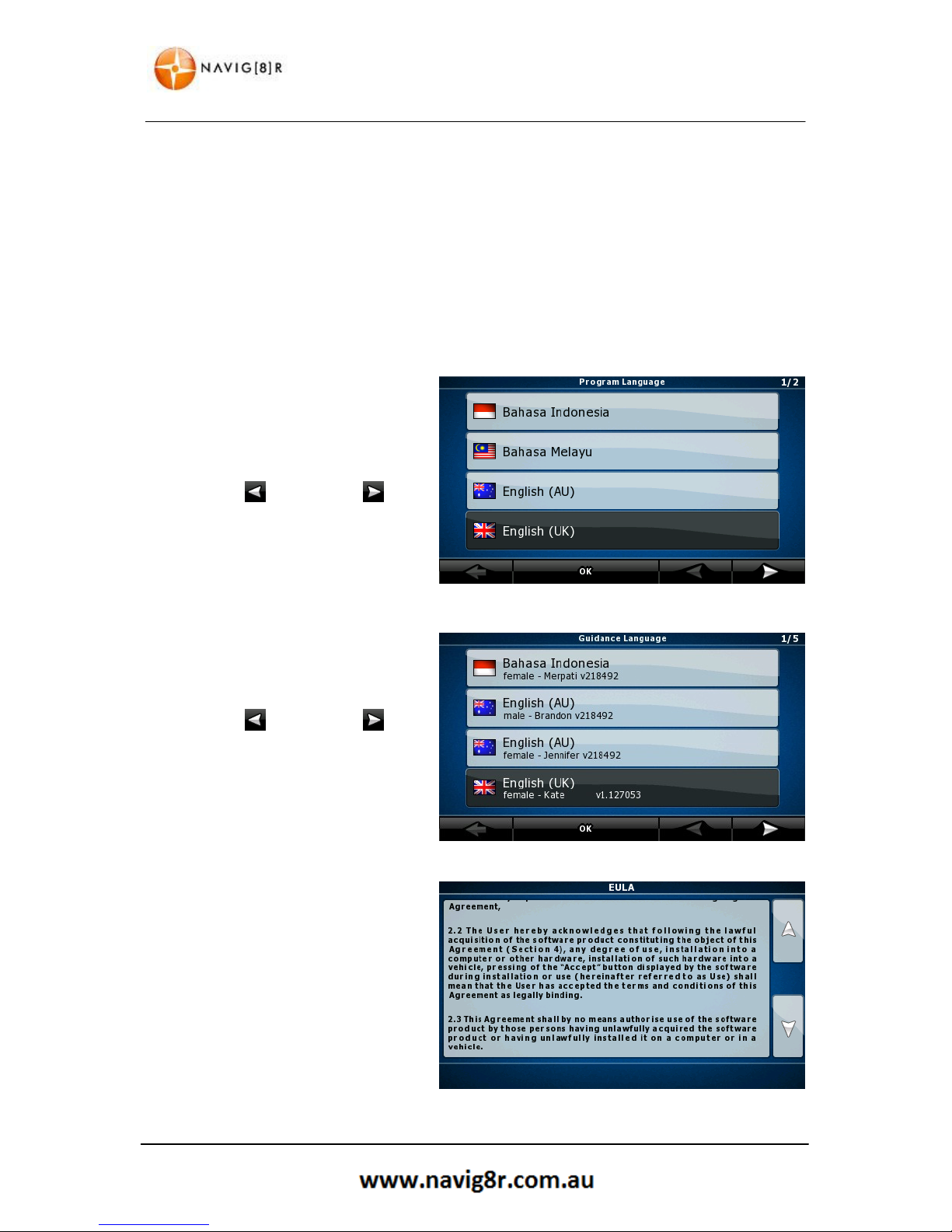
Do as follows:
1. Select the written language of the
application interface.
Later you can change it in Regional
settings.
Tap the button, or the
button to scroll through the
selection. Tap the
OK
button to
confirm the selection.
2. Select the language that you would
like to hear the voice commands
in.
Tap the button, or the
button to scroll through the
selection. Tap the
OK
button to
confirm the selection.
3. Read through the EULA (End User
Licence Agreement).
Tap the down arrow to scroll
through to the end of the
Agreement.
Tap the ACCEPT only if you agree
to the conditions to continue.
Tapping decline will exit the
navigation software

11
GETTING STARTED WITH YOUR NAVIG8R GPS SYSTEM
4. Select the type of menu to be
displayed.
Simple: Shows only the most
commonly used menu item.
Advanced: Shows all available
features.
Select one to advance.
5. Navigation Menu (Advanced)
6. Navigation Menu (Simple)
7. Tapping the MAP button in either
menu will display the map screen.
Shown is the default screen with
not satellite signal Tap the Menu
Button to return to the Navigation
menu to enter in an address.
12
GETTING STARTED WITH YOUR NAVIG8R GPS SYSTEM
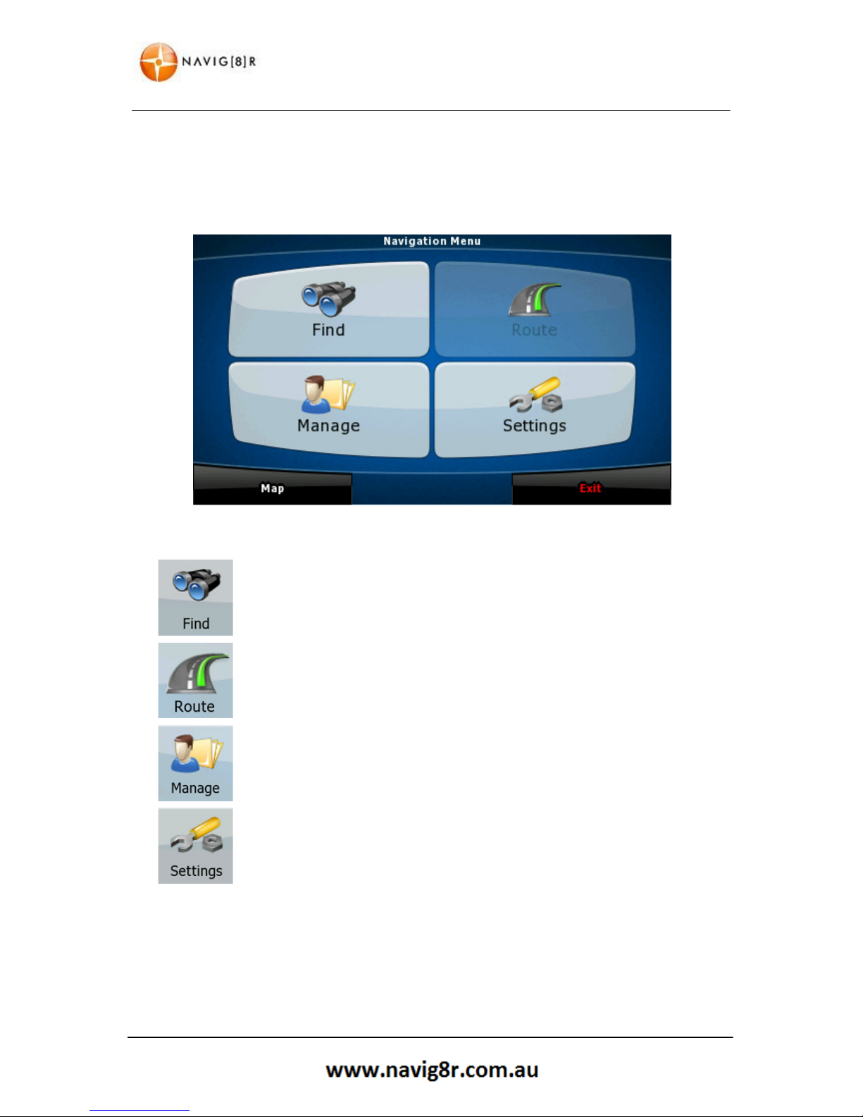
2.1 Start Up Screen: The Navigation Menu
The software starts with its main menu, the Navigation Menu. From here you can reach all parts of
the Software
Tap to select your destination by entering an address or selecting a place of
interest, a location on the map and or select from one of your Favourites.
Shows the route parameters and the route in its full length on the map. You
can also perform route related actions such as editing, alter route settings,
or avoid parts of the route.
Customise the way the navigation software works and looks, watch the
Tutorial
, simulate demo routes, or run some additional applications.
Use to configure the program setting and modify the behaviour of the
Navigation software.
Map
Exits the Navigation Window and returns to the main map screen.
Exit
Exits the Navigation Software and returns to the Main Hardware menu.
13
GETTING STARTED WITH YOUR NAVIG8R GPS SYSTEM
2.2 Buttons and Other Controls on the Screen
When you are using the software, you usually tap buttons on the touch screen.
You only need to confirm selections or changes if the application needs to restart, it needs to
perform a major reconfiguration, or you are about to lose some of your data or settings. Otherwise,
the software saves your selections and applies the new settings without confirmation as soon as you
use the controls.
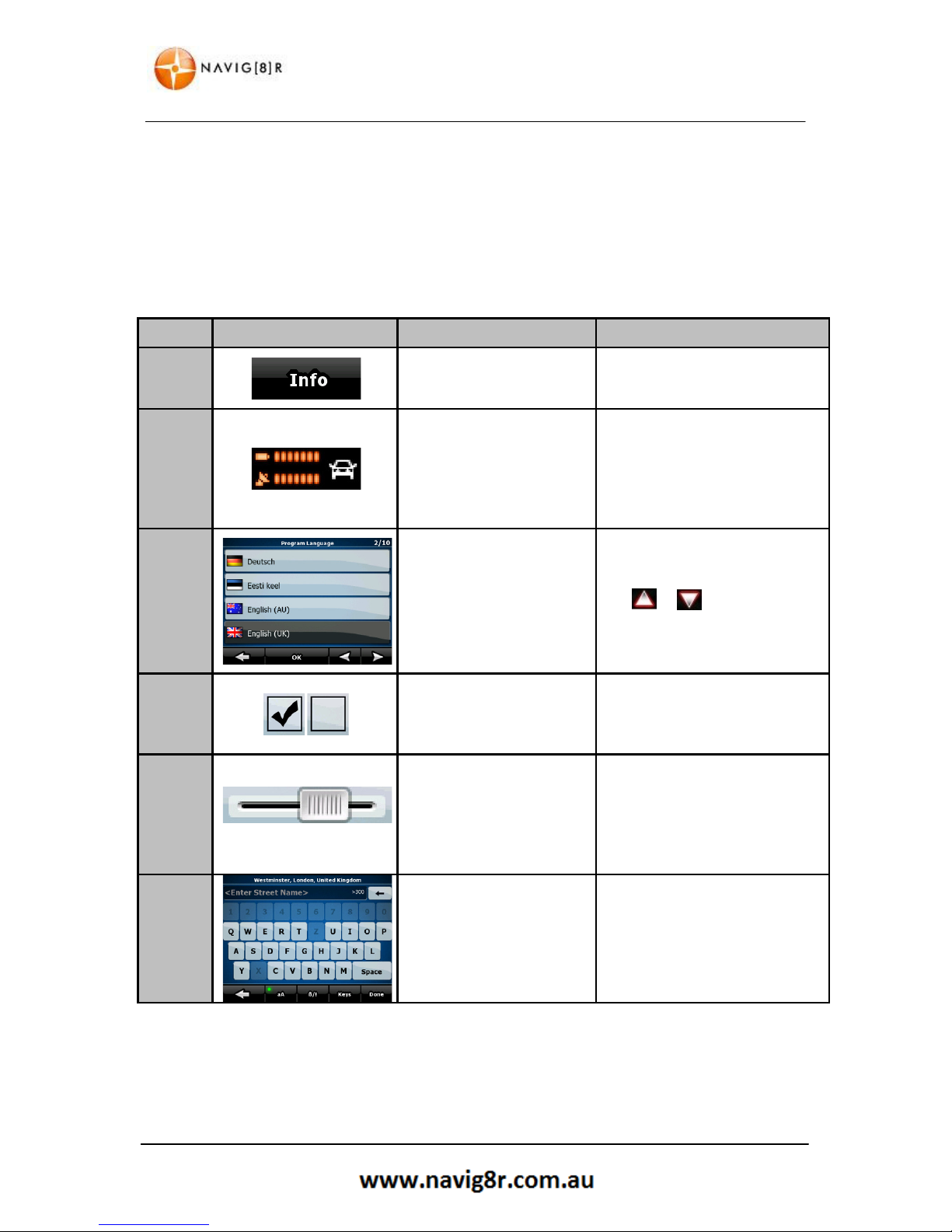
TYPE EXAMPLE DESCRIPTION HOW IT WORKS
Button
Tap it to initiate a function,
to open a new screen, or to
set a parameter.
Tap it once
Icon
Some buttons
/Icons
display
the current value of a field
or setting. Tap the button
to change the value. After
the change, the new value
is shown on the button.
Some icons function as buttons.
Tap to change
List
Displayed when Several
options are available.
List can be moved by sliding
finger tip up and down the
screen until the list ends or using
the & to move between
pages. Tap on the required
selection and then the
conformation button if required.
Switch
When there are only two
choices, a checkmark
shows whether the feature
is enabled.
Tap it to turn the switch on or
off.
Slider
When a feature can be set
to different values in a
range, the software shows
an indicator on a gauge
that displays and sets the
value.
Drag the handle to move t
he
slider
to its new position.
Tap the
slider
where you want
the handle to appear; the thumb
jumps there.
Virtual
Keyboard
Alphabetic and
alphanumeric keyboards to
enter text and numbers.
Each key is a touch screen
button.
Only available letters or numbers
will be available to touch

14
GETTING STARTED WITH YOUR NAVIG8R GPS SYSTEM
2.2.1 Using Keyboards
You only need to enter letters or numbers when you cannot avoid it. You can type with your
fingertips on the full-screen keyboards and you can switch between various keyboard layouts, for
example English, Greek or numerical.
TASK
INSTRUCTION
Switching to another keyboard layout, for
example from an English keyboard to a
Greek keyboard
Tap the / button and
select the new keyboard layout from the list.
Correcting your entry on the keyboard
Tap to remove the unneeded
character(s).
Tap and hold the button to delete several characters
or the entire input string.
Entering a space, for example between a
first name and a family name or in multiword street names
Tap the button at the bottom
centre of the screen.
Entering lowercase or capital letters
Tap to cycle through entering lowercase
letters, initial capitals or all capitals.
Entering symbols
Tap to switch to a keyboard offering symbol
characters.
Finalising the keyboard entry (saving your
input)
Tap /

15
MAP SCREEN
2.3 Map Screen
2.3.1 Navigating On The Map
The
map shows the
current position
(the
Vehimarker, a blue arrow by default).
When there is no
GPS
position, the
Vehimarker is transparent. It shows your
last known position.
During navigation the route to be taken is
marked in orange.
There are screen buttons and data fields
on the screen to help you navigate.
During navigation, the screen shows
route information.
Symbol
Name
Action
Next Turn Preview Opens the Route information Screen
Second Turn Preview Opens the Itinerary screen
Trip Data Opens the trip information screen
Battery/Power staus Opens the Quick menu
GPS Status indicator Opens the Quick menu
Vehicle used in route Calculation Opens the Quick menu
TOP Bar
Next Street or Suburb Additional icons/button or information may
Bottom Bar
Current Street Be displayed briefly on the screen
16
MAP SCREEN
Symbol
Name
Action
,
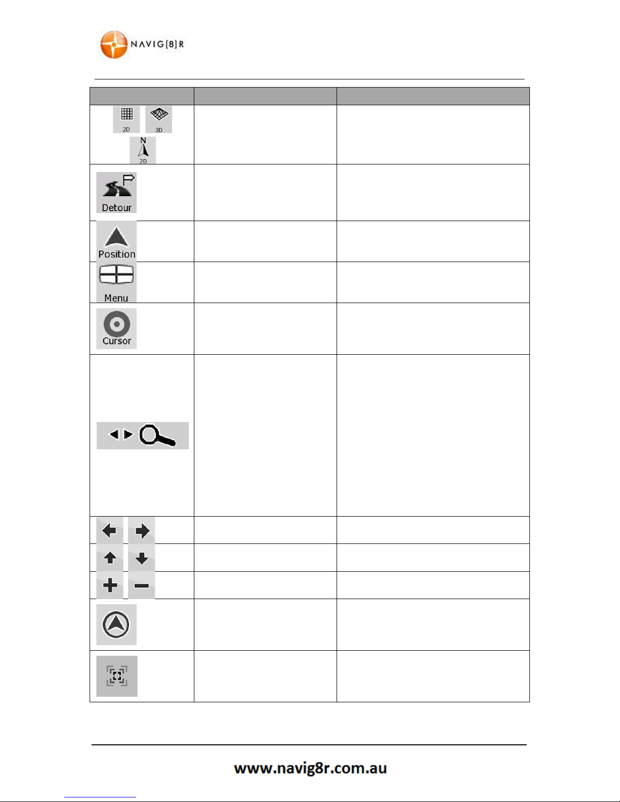
Map View Modes (cycle)
Switches between 2D & 3D Map modes
• 2D North Up
• 2D rotated
• 3D rotated
Detour
Opens the Detour Screen offering 2 ways
of modifying the route:
• List of saved search Criteria
• A button to avoid parts of route
Position Menu Opens the position menu
Menu Opens the Navigation menu
Cursor(Shown only when there
is no GPS position or the
cursor has been moved from
the current GPS location)
Opens the Cursor menu
Open/Close Map Control
buttons
Tap this button to show or hide the
following map control buttons.
• Zoom In/Out
• Rotate left/right (3D map only)
• Tilt up/down (3D map only)
• Zoom preset buttons (2D map
only)
• Tilt and Zoom preset buttons (3D
map only)
• Return to GPS position button
• Smart Zoom button
Rotate left & Rotate right Rotates the 3D map Left or Right
Tilt up & Tilt down Tilts the 3D maps
Zoom in & Zoom out
Scales the map
Return to GPS position
(appears when GPS position is
available and the map has
been moved)
Tap this button to move back to the
current GPS position. If the map has
rotated, automatic map rotation is also reenabled.
Enable Smart Zoom
(replaces
the previous button if there is
no GPS position or the map
has not bee moved)
Tap this button to enable Smart Zoom.
Tap and hold this button to set Zoom
limits of Smart Zoom

17
MAP SCREEN
Symbol
Name
Action
,
Zoom preset buttons
(available in Advance mode
only)
Tap one of the preset buttons to set the
zoom level to a fixed predefined value.
Smart Zoom is disabled. These buttons are
available in 2D mode.
Tap and Hold any of the buttons to set its
value to the current zoom level or to reset
it to the default value
,
Tilt preset buttons (available in
Advance mode only)
Tap one of the preset buttons to set the
tilt and zoom level to a fixed predefined
value. Smart Zoom is disabled. These
buttons are available in 3D mode.
Tap and Hold any of the buttons to set its
value to the current tilt and zoom level or
to reset it to the default value
Current GPS position (on
nearest road)
No Action Available
Cursor (selected map location) No Action Available
Orange Line
Active route No Action Available
Map Scale (2D only) No Action Available
Speed Limit* No Action Available
Note: Speed Limit data is limited to the Major road network only (Highways, Motorways and toll
roads). Metropolitan and suburban speed limits are not displayed.
Drivers must be aware of the speed limit of the road they are driving on at all times .

18
MAP SCREEN
2.3.2 Status Information and Hidden Controls on the Map.
The following information appears in the rounded field in the top left corner, the Turn preview field.
When tapping this area the result will depend on the information currently shown.
ICON
INFORMATION
DETAILS
ACTION
There is no active
route in Simple
mode.
If there is no active route in
Simple mode, this icon is shown
in the Turn Preview field.
Tap this area to open
Find Address.
There is no active
route in Advance
mode
If there is no active route in
Advance mode, this icon is shown
in the Turn Preview field.
Tap this area to open
the Find Menu
There is no valid GPS
signal
If an active route exists, and there
is no valid GPS signal, the view of
the sky above is shown with
coloured dots for each found
satellite. 4 or more dots need to
turn green to be able to navigate
Tap this area to open
the Route Information
Screen.
If static route
recalculation is
needed
GPS Position and an active route
are available but automatic offroute recalculation is switched
off, and you have deviated from
the route
Tap this area to
recalculate the
recommended route.
Automatic off-route
calculation is also reenabled
If animated route
recalculation is in
progress
route recalculation is in progress No action is available
Next route event
(image will vary)
GPS position and active route is
available and you are navigating
the recommended route. This
area shows information about the
type and distance of the next rout
event.
Tap this area to open
the Route Information
Screen.
There is no GPS
signal.
If there is no GPS signal, this
symbol is shown.
Tap to open the GPS
DATA screen to check
the signal status and
connection settings
Stops route
simulation if running
Icon is shown if running Route Fly
Over, Route Simulation or track
log playback
Tap to stop the
simulation.
Recalculation
progress
Show during recalculation No action is available
Indicator Strip
Sound is muted
Track Log Recording
Tap to open the
Itinerary screen with
turn by turn
instructions

19
MAP SCREEN
2.3.3 Variable Data fields.
The following information can be seen in
the three data filed shown on the map
screen. Tap this area to open the Trip
Information screen where you can select
which values are shown on the map
screen in these three fields.
ICON
TYPE
MORE INFORMATION
Compass
Shows the direction of your heading both when the map si
automatically rotated and when the map is always facing
North.
Speed information
The Speed values
that can be shown are:
• Current Speed
• Speed Limit on Current Road (if available)
Time Information
The Time values that can be shown are:
• Current GPS time
• Time remaining to destination
• Time remaining to next via point
• Estimated Arrival Time at destination
• Estimated Arrival Time at next via point
Distance information
The distance values that can be shown are:
• Distance remaining to destination
• Distance remaining to next via point
• Current altitude.
When there is no active route these fields will display Current Speed, Compass and the current Time
of Day.

20
FIND MENU
3 Navigation Menu
From the map screen tap the menu icon
to enter the Navigation Menu. Here you
can set your destination as well change
the way the software looks and behaves.
The menu shown to the right is the
Advanced menu.
Tapping the EXIT button will exit the
navigation software to the main system
menu.
3.1 Setting a Destination
Tap the
Find icon in the
Navigation Menu.
You can set the destination by directly
entering an address, selecting a POI
(Point Of Interest), Selecting a destination
from the History, a set of GPS coordinates , a destination you have saved
as a favourite or even plan your route
directly from the map.
3.1.1 Finding an Address
Tap the
Find Address icon to enter the
address of your destination.
The Country will default to Australia, to
change the country to another map
installed on the GPS tap the top bar and
the select the country.
The GPS will search for an entered suburb
from all states in the map but it can take
longer to do so. If the state is known tap
the second bar to select the state you
Tap the clock icon to the right of suburb to display the history of selected suburbs
for quick selection.
At any time while entering and address you can tap the button to delete the last
character entered. Press and hold to delete several characters at a time.

21
FIND MENU
3.1.2 Entering a State
From the Fin
d Address screen tap the
second bar to select a state.
Tap the or the Change the page
to display more and then tap on the
desired selection when it is shown.
You will be returned to the previous
screen when the selection has been
made.
Tap to return to the previous
screen without making a selection.
3.1.3 Entering a Suburb
From the Find Address screen tap the
third bar to select a suburb.
Using the Keypad enter the suburb by
name or by Postcode.
Only letters and number for postcode that
are in the selected state will be displayed.
For example: the selected state is the ACT.
In the ACT there are No suburbs that start
with the letter Q, J, Z, X or V so these keys
are greyed out.
As all postcodes in the ACT begin with the number 2 only this number is available. The available
letters and number will change with each letter or number selected.
Located on the bottom row are the following buttons.
Button
Action
Tap to Cycle through entering lowercase letter, initial capitals or all
capitals
Tap to switch to a keyboard offering symbol characters.
Tap to select from a list a available Keyboard types.
Tap to have the software search all available suburbs for th
e street you
are about to enter. Please note the by selecting All some delay may be
experience when entering street name.
Tap to return to the previous screen without making a selection.

22
FIND MENU
3.1.4 Entering a Street
From the Find Address
screen tap the
fourth bar to select a street.
Using the Keypad enter the street.
As with the other screens, only letters that
are in the selected suburb will be
displayed.
Use the buttons on the bottom row to
change the input style.
3.1.5 Entering a Street Number
Tap the last bar on the Find address
screen to select street number.
As with the other screens, only number
that are in the selected street/suburb will
be displayed.
Use the buttons on the bottom row to
change the input style.
3.1.6 Finalising the Destination
With the address entered the screen
shown to the right is displayed.
Tap the set as Destination button for the
Navig8r to begin the route calculation.
Or tap the More options Button for other
actions.

23
FIND MENU
3.1.6.1 Destination Options
The buttons and their functions on this screen are the following:
BUTTON
DESCRIPTION
Creates a new route with the course as the start point.
If an active route already exists, press to add this selection as a via or
way point in the active route
Marks the map with a pin at the cursor
Opens a screen with the name address and co-ordinate information
of the Cursor and a list of POIs near it.
3.1.6.2 Further Destination Options
Tap the More Options button
BUTTON
DESCRIPTION
Shows the different routing methods used to calculate the route.
Tap to change the method for this route. (Advance mode only)
In the active route, uses the Cursor as the start point by replacing
the current GPS position. (Advance mode only)
If an active route already exists, press to add this selection as a via or
way point in the active route. (Advance mode only)
In the active route uses the Cursor as the destination while keeping
the previous destination as a via point. (Advance mode only)
Save the Cursor as a POI (Advance mode only)
Marks the map with a pin at the cursor (Advance mode only)
Save the Cursor location as a Favourite destination
Saves the Cursor location as a Road Safety Camera location.
(Advance mode only)*
*This button is not displayed when GPS position is not available or if you are in
certain countries where Road Safety Camera warning is prohibited. Even if the
button is available, you are responsible for checking whether it is legal to use this
feature at your location.

24
FIND MENU
3.2 Finding a POI
By selecting the Find POI button on the
Find menu as shown previously, you can
search for a Point Of Interest by several
methods.
Please see below for more details.
BUTTON
DESCRIPTION
Enter an address, as described previously to search for a POI around.
Move the Cursor around the map itself and find a specific point to
search for a Point Of Interest around.
Search for a POI around the current GPS position.
Search for the POI around the destination of the Active route.
The POI will be searched for not around a given point but by the size
of the detour it will add to the active route. This is use full to search
for a later stopover that cause only a minimal detour, for example
petrol stations and rest stops.
Tap to show a list of Saved Search Criteria for POIs. This list include
specific searched for:
Fist aid
Petrol Stations
Parking
Rest Areas
Accommodation
Cash Dispensers
(ATM)
Shopping
Restaurants
Car repairs
Once the POI has been selected proceed with

25
FIND MENU
3.2 Destination History
By selecting the History button on the
Find menu as shown previously, you can
search for a previously selected
destination.
Tap the or the Change the page to
display more and then tap on the desired
selection when it is shown.
You will be returned to the previous
screen when the selection has been made.
Tap to return to the previous
screen without making a selection
3.2 Find GPS Coordinate
By selecting the Find Coordinate button
on the Find menu as shown previously,
you can search for a prices GPS location
for your destination.
Enter the Latitude and Longitude
individually
Change the display format to enter the
coordinates with different formats.
3.3 Find Favourite
By selecting Favourite button on the Find
menu as shown previously, you can search
for a destination that has been saved as
favourite.
Tap to return to the previous
screen without making a selection

26
MANAGE MENU
4 Manage Menu
By selecting the Manage button in the
Navigation menu you will be presented
with the Manage Menu. Form here you
are able to Manage the data used and
saved by the Navig8r Software
Please see below for further details.
Tap to return to the previous
screen without making a selection or tap
the HELP button for detailed information
about the Manage Menu.
4.1 Manage Menu Explained
BUTTON
DESCRIPTION
Rename or delete Saved Routes
Recording, Simulation, renaming or deleting track logs and assigning
colour to them to be shown on the map.
Creating, updating or deleting POIs.
Creating, updating or deleting POI groups.
Modifying POI visibility settings,
Deleting History items
Renaming or deleting favourites
Creating, renaming or deleting Saved Search Criteria
Manage the data you have saved (e.g. POIs, Favourites or History)
and the settings you have made in the program.
27
MANAGE MENU
4.1.1 Manage Menu Controls
In the Manage sub menus the following control buttons are in use.
BUTTON
DESCRIPTION
Delete the selected item.
or
Clear list/lists
&
Move between pages for additional items
or
Starts recording the tracks while you are driving (also in the Quick
Menu)
or
Stops recording Track Logs (also in the Quick Menu)
Starts the simulated playback of track logs on the map.
Hides the Track Log on the Map. No colour will be assigned to the
Track Log.
Tap one of the coloured buttons to assign a colour to the track log.
The Track log will be displayed on the map in this colour.
or
The map returns with the Track Log. The map is scaled to show the
whole Track Log.
or
Saves the Track Log in the inserted memory card (not supplied) in
GPX format for use in computer software.
Opens the selected POI group for editing
or
Tap to filter the list to contain only the POIs that you have saved.
or
Tap to see all the POIs in the list
or
Creates a new POI group at the given group level.
This POI group is not shown on the map.
This POI group and all its subgroups are shown on the map
This POI group and some of its subgroups are shown on the map.
This POI group contains POIs that you have saved.
Further icons and buttons than shown may appear in the Manage Menus and sub Menus,
28
ROUTE MENU
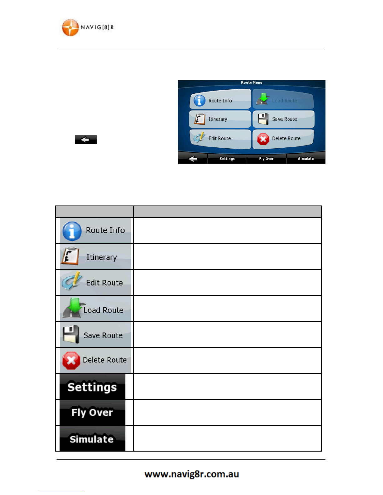
4 Route Menu
By selecting the Route button in the
Navigation menu you will be presented
with the Route Menu. Form here you are
able to Manage the Route methods and
saved data.
Please see below for further details.
Tap to return to the previous
screen without making a selection.
4.1 Route Menu Explained
BUTTON
DESCRIPTION
Opens a useful screen with route data.
Browse the driving instructions that the Navig8r presents during
navigation. You can exclude manoeuvres or streets to adjust the
route to you preference.
You can modify the route, remove route points or change their
order.
Load a previously saved route for navigation.
Save the active route for later use.
Erase the active route with all it via points. Once a route has been
deleted it will need to be created again,
Opens the Routes Settings Menu. Change the Vehicle, Road types
used and type of route to be calculated (fast, easy or Economical
etc.)
Displays a fly over of the selected route at high speed.
Runs a simulation of the selected route at normal speed

29
SETTINGS MENU
5 Settings Menu
By selecting the Settings button in the
Navigation menu you will be presented
with the Settings Menu. Form here you
are able to Manage the look and feel of
the Navigation software.
Tap the or the Change the page to
display more and then tap on the desired
selection when it is shown
Please see below for further details.
Tap to return to the previous
screen without making a selection.
5.1 Route Menu Explained
BUTTON
DESCRIPTION
You can fine tune the appearance and the content of the map
screen.
These settings determine how the routs will be calculated.
Control how the Navig8r behaves during Navigation.
You can adjust the sounds of the Navig8r
Use these settings to adjust the software to your preferred
language, unit of measurements, time and date formats as well as
different voices guidance profiles.
You can enable some useful warning as well as disabling the touch
screen while the vehicle is in motion.
Check the GPS antenna settings
Modify the look and behaviour of the Menu screens.
Set Automatic Track Log Saving and fine tune related settings.

30
SETTINGS MENU
BUTTON
DESCRIPTION
TMC (Traffic Management Channel) is not available for this model
Navig8r.
Fine tune device related settings such as Power Management and
Screen backlight setting.
The About screen simply provides information about Software
version and copyright details as well as showing installed map
versions
Switches Menus or Simple mode. In simple mode only a few of eth
above items are accessible.

31
GLOSSARY
6 Glossary
2D/3D GPS reception
The GPS receiver uses satellite signals to calculate its (your) position and needs at least four signals
to give a three-dimensional position, including elevation. Because the satellites are moving and
because objects can block the signals, your GPS device might not receive four signals. If three
satellites are available, the receiver can calculate the horizontal GPS position but the accuracy is
lower and the GPS device does not give you elevation data: only 2D reception is possible.
Active Route
The currently navigated route. Whenever the destination is set, the route is active until you delete it,
reach your destination or you quit the software. See also: Route.
City Centre
The city/town centre is not the geometric centre of the settlement but an arbitrary point the map
creators have chosen. In towns and villages, it is usually the most important intersection; in larger
cities, it is one of the important intersections.
Colour Theme
Your software comes with different colour themes for daytime or night use of the map and menu
screens. Themes are custom graphic settings and they can have different colours for streets, blocks
or surface waters in 2D and 3D modes, and they display shades or shadows in different ways in 3D
mode.
One daytime scheme and one night scheme is always selected for the map and for the menus. The
software uses them when it switches from day to night and back.
GPS Accuracy
Several factors have impact on the deviation between your real position and the one given by the
GPS device. For example, signal delay in the ionosphere or reflecting objects near the GPS device
have a different and varying impact on how accurately the GPS device can calculate your position.
Map
The software works with digital maps which are not simply the computerised versions of traditional
paper maps. Similarly to the paper road maps, the 2D mode of digital maps show you streets, roads,
and elevation is also shown by colours.
In 3D mode, you can see the altitude differences, for example valleys and mountains, elevated
roads, and in selected cities 3D landmarks and 3D buildings are also displayed.
You can use digital maps interactively: you can zoom in and out (increase or decrease the scale), you
can tilt them up and down, and rotate them left and right. In GPS-supported navigation, digital maps
facilitate route planning.

32
GLOSSARY
North-Up Map Orientation
In North-up mode the map is rotated so its top always faces North. This is the orientation for
example in Find on Map. See also: Track-up map orientation.
Road Safety Camera
Special alert points for speed, red light or bus lane cameras. Different data sources are available. You
can configure the software to warn you when you approach one of these cameras.
Detecting the location of Road Safety Cameras is prohibited in certain countries. It is the sole
responsibility of the driver to check whether this feature can be used during the trip.
Route
A sequence of route events, i.e. manoeuvres (for example, turns and roundabouts) to reach the
destination. The route contains one start point and one or more destinations. The start point is the
current (or last known) position by default. If you need to see a future route, the start point can be
replaced with any other given point.
Track-Up Map Orientation
In Track-up mode the map is rotated so its top always points in the current driving direction. This is
the default orientation in 3D map view mode. See also: North-up map orientation.
Vehimarker
The current position is shown with a blue arrow on the map by default. The direction of the blue
arrow shows the current heading. This position marker can be replaced with different vehicle and
pedestrian symbols. You can even specify different Vehimarkers for different route types (depending
on which vehicle type is selected for route calculation).

33
HARDWARE
Hardware

34
MAIN SYSTEM MENU
7 Main System Menu
To access the Navig8r Main System Menu tap on the Exit button in the Navigation software. The
software will shut down and the following screen will be displayed.
The Main menu allows you to set the defaults or tailor the device settings to best suite your needs.
In most cases “out of the box” settings will be more than adequate for most users some settings can
be changed to adjust the backlight, system menu language, retrieving system information or even
recalibrating the touch screen.
Tapping on each will access different sub menus and features.
Note: Prior to launching any features that may access the Micro SD card reader, please ensure that
the card is inserted correctly in the SD card slot on the side of the unit. If the Navig8r has been sitting
for a long period without use, please remove the card from the slot and reinsert the card in the slot.
Repeat two or three times to ensure that good contact is made.
While it is possible to transfer files to the internal memory we recommend that all multimedia files
are stored and accessed from Micro SD card
No SD card is required for the Navigation software to function.

7.1 GPS
The GPS icon launches the Please refer to the front section of this manual.
7.2 SYSTEM
Item Title
A Home Button
B Language
C Backlight
D Page title bar
E Power
F Sound
G Back Button
H Time
I System
J CO.adjust
MAIN SYSTEM MENU
Description
Tap on any screen to return
to the Main System Screen
Enters the system language settings
Enters the system backlight settings
Shows title of current menu
Enters the system power settings
Enter the system sound settings
Tap on any page to go back one screen.
Enters the system time and region settings
Enters the System Information page
Tap to recalibrate the Navig8r touch screen
35

7.2.1 Language
7.2.2 Backlight
Disabled = ALWAYS ON
7.2.3 Power
NO = ALWAYS ON
MAIN SYSTEM MENU
Use the and the
through the options and then tap the required
language.
Tap the language to be displayed in the main
system menu.
Tap the
button to return to the previous
screen or the
button to return to the
Main System screen.
Use the and
buttons to decrease or
increase the backlight level.
Use the and
buttons to s
the backlight will turn off.
Tap the
button to return to the previous
screen or the
button to return to the
Main System screen
Gives and indication of the current charge level.
Use the
button to select a time to for the
GPS to automatically sleep after last screen tap
Tap the
button to return to the previous
screen or the
button to return to the
Main System screen
36
buttons to scroll
et the time

37
MAIN SYSTEM MENU
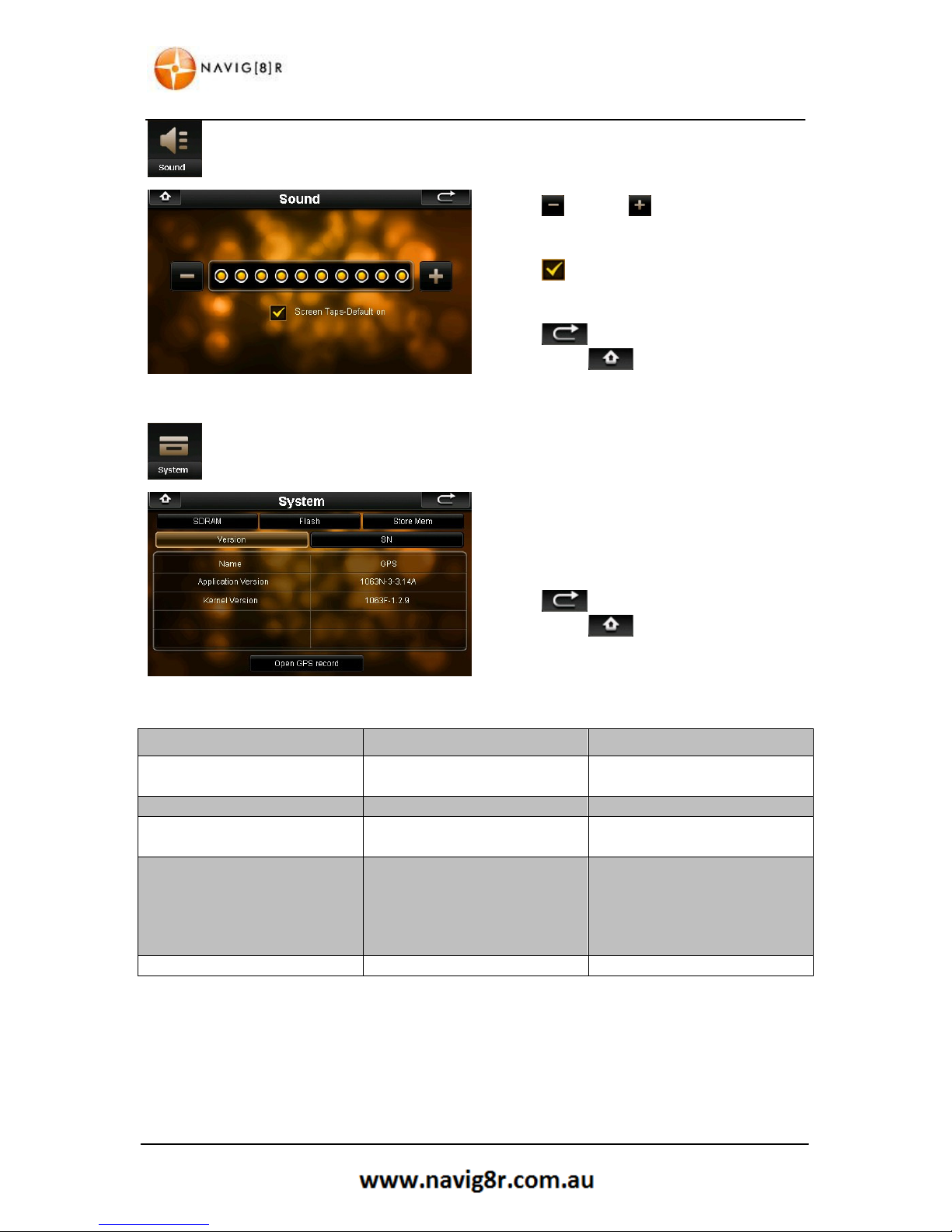
7.2.4 Sound
Use the and the buttons to decrease or
increase the volume level for you GPS.
Tap the icon to disable or enable Screen tap
sounds.
Tap the button to return to the previous
screen or the button to return to the
Main System screen.
7.2.5 Time
Use the and the buttons to set the
correct value for each field.
Fields are YYYY – MM – DD
HH - MM - SS
Then use the button or the to set the
correct time zone
The new Date Time and region information will be saved as soon as this menu is exited.
Tap the button to return to the previous screen or the button to return to the Main
System screen.
NOTE: The times settings made in this menu are valid for the system features only. The Navigation
software is set to automatically detect can calculate and display the correct Time and Date using the
Time & Date code in the GPS satellite signal and the actual location of the GPS.
The GPS navigation software can be set to accept the time, date and region information from the
hardware.
While not absolutely required we strongly recommend that the Time, Date and Region settings be
set.
38
MAIN SYSTEM MENU
7.2.6 Sound
Use the and the buttons to decrease or
increase the volume level for you GPS.
Tap the icon to disable or enable Screen tap
sounds.
Tap the button to return to the previous
screen or the button to return to the
Main System screen.
7.2.7 System
Tap each TAB to display information about each
heading.
Tap the button to return to the previous
screen or the button to return to the
Main System screen.
TAB
Title
Description
VERSION
Application
Application version number
Kernel Version
Kernel version number
SN Serial Number
Device Serial number
SDRAM
Total SDRAM
Displays total System Ram
Usable
SDRAM
Displays usable system ram
FLASH
Flash Space
Total Space on device
NandFlash Used
Used space on device
Usable NandFlash
Available space on device
SD Capacity
SD card Capacity (if fitted)
SD Card Used
Used SD card Capacity (if fitted)
STORE
MEM
Store Memory
Shows size of available memory
Open GPS Record: This feature allows for data to be collected direct from the GPS antenna and is
reserved for diagnostic and troubleshooting purposes. Data may be requested from this feature by
Navig8r Support.

7.3 Tools
7.3.1 Calculator
7.3.2 Picture Viewer
Start Slideshow
Display in full screen
Tap the
button to return to the previous screen or the
System screen.
MAIN SYSTEM MENU
Use the numeric keypad and function key as
needed.
Use the
AC
button to
clear the whole display or
the
button to remove the last digit only.
Tap the
button to return to the previous
screen or the
button to return to the
Main System screen.
If no images are displayed please press the
button to search for images.
Use the or
buttons to scroll through the
list, tap the on the image to view then press the
button to view the image.
Display previous image
Display next image
Zoom In
Zoom out
Rotate image 90°
clockwise
(tap screen to end)
Display image in original size
(tap screen to exit)
Return to file index screen
button to return to the Main
39

40
MAIN SYSTEM MENU
7.4 GPS Test
The GPS test page shows information about the
number of satellites detected and the quality of
the signal.
Tap the GPS Reset button to reset the GPS
antenna if reception difficulties are noticed.
Tap the button to return to the previous
screen or the button to return to the
Main System screen.

41
CHARGING THE NAVIG8R
8 CHARGING THE NAVIG8R
The Navig8r will charge when connected to a power source. This source can be the AC adaptor, the
DC charger or when connected to a powered USB port.
Charging will take approximately four hours. To reduce charging times please turn the Navig8r OFF
or place in sleep mode.
9 CONNECTING TO A PC
By default the Navig8r will connect to a PC running Window 2000 or Later by simply connecting it to
the PC with the supplied USB cable. This is the preferred method of connection.
The Naviag8r must be turned on and the navigation software must be exited before connection to
the PC. It is detected as a removable device and displayed in the (My) Computer window and a two
removable discs and be assigned the next available drive letter.
The first drive will represent the internal flash storage area of the Navig8r where the Navigation
software is stored. Care should be taken as deletion of any files on this drive may result in the
failure of the navigation software.
The Navig8r may use more power than a standard USB port on a PC can provide. It is important that
the Navig8r be fully charged prior to any update procedure.
10 FRESH MAP GUARANTEE
Within 30 days of first GPS acquisition*, register your product and receive the latest map update via
the online website free of charge.
To complete the update you will need to have internet access. You will be required to register (free)
and download and install the Toolbox software from the
http://www.naviextras.com
.
Please refer to this website for detailed instructions.
If the update is not completed within this 30 day period the free update is forfeited and cannot be
re-applied.
11 TECHNICAL SPECIFICATIONS
Please refer to the Navig8r website for the latest technical specifications on this product.
Disclaimer:
LASER Corporation reserves the right to make any changes to the software
or hardware specifications with notice as deemed necessary. Information
and images provided in this manual may vary from actual product.

42
FREQUENTLY ASKED QUESTIONS
12 FREQUENTLY ASKED QUESTIONS
Q: What is GPS?
A: GPS stands for Global Positioning System. Officially named NAVSTAR GPS, It is a satellite-based
radio navigation system developed and operated by the U.S. Dept of Defence. GPS is operated and
controlled by the Government of the United States of America, who are responsible for the
availability and accuracy of the system. The system is allowed to be used free of charge.
GPS signals are available to an unlimited number of users simultaneously, and allow users to find
their position on land, sea and in the air, the correct time, and velocity 24 hours a day anywhere on
earth. The first GPS satellite was launched in 1978 and the full constellation of 24 satellites was
achieved in 1994. A GPS satellite weighs in at about 900 kilograms and lasts about 10 years before it
is required to be replaced.
Q: How does GPS work?
A: The GPS Navigation system is made up of three segments
The Space Segment: This is currently made up of a network of 31 satellites orbiting the earth at an
altitude of approximately 19,000 kilometres and travels at about 11,000 kilometres per hour. They
orbit the earth twice per day along 6 circular orbital planes. They are positioned so that every inch of
the surface of the earth can receive signals from at least 6 of these satellites. GPS satellites transmit
signals constantly. These signals are aimed at earth based receivers such as GPS navigation systems.
Each satellite transmits data about its location and height of orbit and the time that the signal was
sent.
The Control Segment: Is the ground based tracking stations around the world that track and monitor
each satellite in the NAVSTAR system. The tracking information is monitored by the United States Air
Force 2d Space Operations Squadron (2SOPS) at the Schriever Air Force Base in Colorado Springs.
2SOPS regularly contact each satellite with navigational updates. These updates also synchronise the
automatic clock on each satellite to within one microsecond and update the orbital data.
The User Segment: is the GPS receiver. This is commonly referred to as a Satnav unit or simply a
GPS. The receiver will obtain information from at least three satellites and calculate the location and
the time it took to receive the signal from each satellite. The receiver then calculates latitude,
longitude, direction and velocity. In conjunction with the map software loaded on to the GPS unit, it
can calculate your exact location, heading, speed and correct time and overlay the results on a map
of the area. The software in the system can also calculate the best route to other locations and give
instructions to the driver on the best route giving fair warning of impending turns. These warnings
can be given visually or audibly depending on the model of the system.

43
FREQUENTLY ASKED QUESTIONS
GPS navigation systems require a clear line of sight to work effectively and will not work indoors.
Function may also be impeded in heavily wooded areas and city streets between high rise buildings
that may impede line of sight to satellites.
In conjunction with the map software loaded on to the GPS unit, the system can calculate your exact
location, heading, speed and correct time and overlay the results on a map of the area. The software
in the system can also calculate the best route to other locations and give instructions to the driver
on the best route giving fair warning of impending turns. These warnings can be given visually or
audibly depending on the model of the system. Different models can have a wide variety of
functions and features.
Q: How accurate are GPS systems?
A: In perfect conditions, GPS navigation systems are generally accurate to 3mtrs. Several factors can
impede the accuracy of the GPS unit. These include atmospheric conditions, signal reflection (or
multipath) and clock errors. Most of these errors are small and are usually only apparent when
stationary. Typically a personal GPS unit is accurate to within 15 meters.
The GPS system is only as accurate as the mapping software in the unit. If the map data is incorrect
the visual representation of you location may not be displayed correctly.
Map data is compiled from several sources and may not be 100% up to date. Councils and regulatory
authorities may change road signs, add or remove traffic lights and roundabouts and change the
direction of traffic along roads at any time and these changes may not have been made at the time
the mapping software was complied.
Q: Why does my Navig8r receiver show that I am moving when I am standing still?
A: Occasionally, GPS satellites may broadcast a signal error called Selective Availability (SA). This can
be displayed as up to 4KPH of movement on the GPS receiver.
Q: The GPS unit will not turn on after charging. What can I do to get it working again?
A: In most cases this problem is easy to resolve. Make sure that the GPS is charged or connected to
a power supply. Remove the Mount Cover form the rear of the device and locate the reset button.
Using the supplied stylus, press the reset button. The GPS unit should now start and load the main
menu. You will need to reset any settings such as the system time and date again.
If the above does not work and the system will not start, please contact the reseller or tech support
support@Navig8r.com.au

44
FREQUENTLY ASKED QUESTIONS
Q: What other factors will affect the accuracy of my Navig8r?
A: While GPS receivers can be quite accurate, there are several factors that can impede the
performance and accuracy of the system. GPS receivers require a clear line of sight to the satellites
to receive the signal.
Bad placement of the receiver in the car can reduce the reception of the signal. This is the most
common cause of poor reception.
Tall buildings in high rise areas such as city streets can impede the signal reception as well as
introducing “Phantom Signals” or Multi Path. These can reflected off buildings and other surfaces,
which make it hard for the GPS receiver to function correctly as it receiving two signals from the
same satellite. This is more apparent when the vehicle is travelling very slowly or at a stop.
Atmospheric conditions such as solar flares and heavily wooded or areas of dense foliage can also
affect the detection of satellite signals.
Q: Can I connect my Navig8r with a Macintosh?
A: The Navigator GPS is detected by computers as Mass Storage devices simular to USB drives. Macs
running OSX 10.2 or later should be able to access the GPS and SD Card Slot by connecting with the
supplied USB cable without the need for any software or drivers to be installed.
Q: My Navig8r is frozen or displays a blue screen, or will not turn on, how do I fix this?
A: Contact technical support.
Q: I cannot find an address!
A: Check the address that you are looking for. The street may be listed as in a different suburb than
your information. Some addresses are given in a “preferred” suburb rather than the actual listed
suburb.
Map data for the Laser Navig8r is sourced from PSMA Australia (formerly Public Sector Mapping
Agencies) and is as up to date as possible at the time of compilation
Q: I can find the street but not the house number.
A: If when entering a destination, the Navig8r cannot find a particular street number but can find the
correct street, try entering a number just above or just below on the same side of the road as the
address you are looking for. For example if you are looking 101 Smith St. but the Navig8r cannot find
it, try looking for 99 or 103 Smith St. House numbers can be spaced differently on one side of the
street to another; the number 100 may be a block or two in either direction.

45
FREQUENTLY ASKED QUESTIONS
Q: I have finger prints over the screen of my Navig8r, how do I clean it?
A: The Navig8r can be cleaned by using a soft damp to dry cloth. Lightly wipe the screen and the case
as required. Use another dry soft cloth to make sure that there is no moisture left on the Navig8r.
Do not use any cleaning products to clean the screen or case of the Navig8r as it may cause damage
to the screen of the finish on the case. Using only the supplied stylus will also help keep the screen
clean.
Q: Where should I position the Navig8r in my car?
A: There are several factors to consider when mounting the Navig8r in the car for use. The unit
should be positioned to give it the best possible view of the sky. This usually means at the base of
the windscreen just above the dashboard. Make sure that the brackets are secure and the unit is
fitted correctly so that the Navig8r doesn’t come loose while driving. It should also be placed so that
it does not hinder the driver’s vision through the windscreen. It also needs to be visible while in a
normal driving position without having to turn your head or take your eyes of the road while driving.
Q: I find it hard to enter an address while driving, what should I do?
A: The driver of a vehicle should not attempt to enter destinations or change the setting on the
Navg8r while the vehicle is in motion. It is very easy to get distracted. Pull over to the side of the
road when safe and enter the destination.
Q: I received my Navig8r as a gift, I need to send it for repairs. What should I do?
A: The Laser Navig8r is covered by a 12 month warranty from the date of purchase on the GPS unit
only. Accessories are not covered by warranty. Replacement accessories packs are available from
where the Navig8r is sold or online at the Navig8r website.
The Laser Navig8r is covered by a 14 day DOA (Dead on Arrival Period). During this period the
Navig8r should be returned to the place of purchase for a replacement.
After the DOA period, please contact technical support for the warranty process. Please remember a
proof of purchase will be required for any warranty claim.
Q: Why do I sometimes find map errors?
A
: While all care is taken, there are a lot of roads out there, and traffic signals, detours etc
are constantly being made to roads. Sometimes the maps may not reflect the true status of
the route shown.

46
FREQUENTLY ASKED QUESTIONS
Q: I am having issues syncing with the satellite
A: Ensure that you have clear access to the sky. Turn the unit off and back on again. If the unit has
been turned off for a period of time it can take a few minute to sync with the satellites again.
Q: When I drive in a large CBD area, the GPS drops out or has trouble syncing
A: CBD areas can have a canyon affect on GPS systems. Not only can tall buildings hide the signal
from GPS satellites, it can also reflect the signals of the satellites that can be detected. This makes it
hard for the GPS unit to calculate the correct position. This is more noticeable at slower speeds. Try
moving to an area that gives a better view of the sky.
For further information about you Navig8r GPS please visit the Navig8r Website at
HTTP://WWW.NAVIG8R.COM.AU
For navigation software or map related issues please visit
HTTP://WWW.NAVIEXTRAS.COM

47
END USER LICENCE AGREEMENT
13 END USER LICENCE AGREEMENT (EULA)
1 The contracting parties
1.1 This Agreement has been entered into by and between Nav N Go Kft. (registered seat: 23 Bérc
utca, H-1016 Budapest, Hungary; Company reg.no.: 01-09-891838) as Licensor (hereinafter: Licensor)
and You as the User (hereinafter: User; the User and the Licensor jointly referred to as: Parties) in
subject of the use of the software product specified in this Agreement.
2 Conclusion of the Agreement
2.1 The Parties hereby acknowledge that this Agreement shall be concluded by implicit conduct of
the Parties without signing the Agreement.
2.2 The User hereby acknowledges that following the lawful acquisition of the software product
constituting the object of this Agreement (Section 4), any degree of use, installation into a computer
or other hardware, installation of such hardware into a vehicle, pressing of the “Accept” button
displayed by the software during installation or use (hereinafter referred to as Use) shall mean that
the User has accepted the terms and conditions of this Agreement as legally binding.
2.3 This Agreement shall by no means authorise use of the software product by those persons
having unlawfully acquired the software product or having unlawfully installed it on a computer or in
a vehicle.
3 Relevant laws and regulations
3.1 To all issues not regulated by this Agreement, the laws of the Republic of Hungary, with specific
reference to Act IV of 1959 on the Civil Code and to Act LXXVI of 1999 on Copyrights shall apply.
3.2 The original language version of this Agreement is the Hungarian version. This Agreement has
versions in other languages as well. In case of dispute the Hungarian version shall prevail.
4 Object of the Agreement
4.1 The object of this Agreement shall be the navigation guidance software product of Licensor
(hereinafter referred to as the Software Product).
4.2 The Software Product shall include the operating computer program, its complete
documentation, the map database pertaining thereto and any third-party content and services
accessible through the Software Product (hereinafter: Database).
4.3 Any form of display, storage, coding, including printed, electronic or graphic display, storage,
source or object code, or any other as yet undefined form of display, storage, or coding, or any
medium thereof shall be deemed parts of the Software Product.
4.4 Error corrections, additions, updates used by the User following the conclusion of this
Agreement shall also be deemed parts of the Software Product.

48
END USER LICENCE AGREEMENT
5 Rights under copyright
5.1 Unless otherwise provided by law or contractual provisions, the Licensor is the sole and exclusive
owner of all material copyrights vested in the Software Product.
5.2 Copyrights extend to the whole Software Product and to its parts separately as well.
5.3 The owner(s) of the copyrights of the Database forming part of the Software Product is (are) the
natural person(s) or corporate entity(ies) listed in the Appendix to this Agreement or in the “About”
menu item of the operating computer programme (hereinafter referred to as Database Owner). The
user's manual of the Software Product includes the name of the menu option where all the owners
of the Database items are listed. The Licensor hereby states that it has obtained sufficient usage and
representation rights from the Database owners in order to utilise the Database, to offer it for
utilisation and to transfer it for utilisation as set forth in this Agreement.
5.4 Pursuant to this Agreement, all rights vested in the Software Product shall remain in the
ownership of the Licensor, except for those to which the User is entitled under law or by virtue of
this Agreement.
6 Rights of the User
6.1 The User is entitled to install the Software Product into one hardware device (desktop, handheld,
portable computer, navigation device), and to run and use one copy of the Software Product or a
preinstalled copy of the Software Product thereon.
6.2 The User undertakes and accepts that the Software Product and/or its certain elements and/or
contents provided by third parties may require separate action (registration/activation) within the
time period specified in the Software product to achieve its partial or full functionality.
6.3 The User is entitled to make one backup copy of the Software Product. However, if the Software
Product operates after installation without the use of the original media copy, then the original
media copy shall be deemed to be a backup copy. In all other cases, the User is only entitled to use
the backup copy if the original media copy of the Software Product has been ascertainably and
unequivocally rendered unsuitable for its lawful and intended use.
7 Limitations of use
7.1 The User is not entitled
7.1.1 to duplicate the Software Product (to make a copy thereof);
7.1.2 to lease, rent or lend it or to transfer it to a third person for any reason;
7.1.3 to translate the Software Product (including translation (compilation) to other programming
languages);
7.1.4 to decompile the Software Product;

49
END USER LICENCE AGREEMENT
7.1.5 to evade the protection of the Software Product or to modify, circumvent or obviate such
protection through technological or by any other means;
7.1.6 to modify, extend, transform the Software Product (in whole or in part), to separate it into
parts, combine it with other products, install it in other products, utilise it in other products, not
even for the purpose of achieving interoperability with other devices;
7.1.7 apart from using the computer program, to obtain information from the Database as a part of
the Software Product, to decompile the Database, to use, copy, modify, extend, transform the
Database in whole or in part or the group of data stored therein, or to install it in other products or
otherwise, utilise it in other products or to transfer it, not even with the aim of achieving
interoperability with other products.
7.2 The User acknowledges that the Software Product may prohibit or block partly or completely the
use of the Software Product and/or its parts and/or third party contents if the separate action
(activation/registration) as specified in Section 6 is not met within the time defined in the Software
Product.
7.3 The User may only use the contents available through the Software Product and provided by
third parties and the data received through the services provided by third parties (including but not
limited to the traffic data received from the RDS TMC traffic information service) for his/her own
personal benefit and at his/her own risk. It is strictly prohibited to store, to transfer or to distribute
these data or contents or to disclose them in full or in part to the public in any format or to
download them from the product.
8 No warranty or limitation of responsibility
8.1 The Licensor hereby informs the User that although the greatest care was taken in producing the
Software Product, given the nature of the Software Product and its technical limitations, the Licensor
does not provide a warranty for the Software Product being completely error-free, and the Licensor
is not bound by any contractual obligation whereby the Software Product obtained by the User
should be completely error-free.
8.2 The Licensor does not warrant that the Software Product is suitable for any purpose defined
either by the Licensor or the User, and does not warrant that the Software Product is capable of
interoperating with any other system, device or product (e.g. software or hardware).
8.3 The Licensor does not assume any responsibility for damages incurred due to an error in the
Software Product (including errors of the computer program, the documentation and the Database).
8.4 The Licensor does not assume any responsibility for damages incurred due to the Software
Product not being applicable for any defined purpose, or due to the error or incompatibility of the
Software Product with any other system, device or product (e.g. software or hardware).
8.5 The Licensor also draws the attention of the User to the fact that, when using the Software
Product in any form of vehicle, observing the traffic regulations and rules (e.g. use of obligatory
and/or reasonable and suitable security measures, proper and generally expected care and attention
in the given situation, and special care and attention required due to the use of the Software
Product) is the exclusive responsibility of the User. The Licensor shall not assume any responsibility
for any damages occurred in relation to use of the Software Product in a motor vehicle.

50
END USER LICENCE AGREEMENT
8.6 By concluding the Agreement, the User shall, in particular, acknowledge the information stated
in Section 8 above.
9 Sanctions
9.1 The Licensor hereby informs the User that, if the Licensor finds its rights under the Copyright Act
to be breached, the Licensor may
9.1.1 seek judicial recognition of this breach;
9.1.2 demand that the breach cease and order the person in breach to refrain from continuing such
actions;
9.1.3 demand that the person under breach give proper compensation (even by way of publicity at
the expense of the person in breach);
9.1.4 claim the return of the increase of assets due to the breach;
9.1.5 demand the cease of the wrongful action and, demand restitution to its state before the
breach was committed at the expense of the person in breach, and may demand the destruction of
instruments and materials used to commit the breach as well as of the products created by the
breach;
9.1.6 claim for damages.
9.2 The Licensor hereby also informs the User that the breach of copyrights and related rights is a
crime under Act IV of 1978 on the Hungarian Criminal Code, which may be sentenced of two years in
prison in basic cases and up to eight years in prison in aggravated cases.
9.3 Contents and services provided by third parties
The Licensor hereby excludes any liability of its own for the Database in the Software Product and
for any content or service provided by a third party by using the Database. The Licensor does not
warrant the quality, suitability, accuracy, fitness for a specific purpose or territorial coverage of the
product or service or the availability of the service, and it specifically excludes any liability for the
suspension of the service, and any damage arising in relation to the service or for complete
cancellation of the service.
The relevant information and data in connection with the contents and services provided by third
parties are available at www.navngo.com. The User hereby acknowledges that the contents and
services provided by third parties may only be used at the risk of the User and for the personal
benefit of the User.
9.4 Contents and services provided by the Licensor or an agent of the Licensor

51
COPYRIGHT NOTICE
The Licensor or a contractual partner may offer various products and services to the User through
www.naviextras.com. The User may only use these services when the User has read and understood
the relevant end user licence agreement(s) at www.naviextras.com and the User is obliged to use
the services in line with the terms and conditions thereof.
9.5 The parties hereby agree that - depending on the nature of the dispute - either the Pest Central
District Court (Pesti Központi Kerületi Bíróság) or the Metropolitan Court of Budapest (Fővárosi
Bíróság) will have exclusive jurisdiction to rule on any disputes arising in connection with this
Agreement.
14 COPYRIGHT NOTE
The product and the information contained herein is subject to change without prior notification.
This manual may not, in whole or in part, be reproduced or transmitted in any form either
electronically or mechanically, including photocopying and recording, without the express written
consent of NNG Global Services Kft..
© 2010 - NNG Global Services Kft.
Data Source © 2006 Tele Atlas N.V.
Austria: © BEV, GZ 1368/2003
Denmark: © DAV
France: © IGN France
Great Britain:
Ordnance Survey data with permission of Her Majesty’s Stationery Office © Crown
Copyright
Italy: © Geonext/DeAgostini
Northern Ireland: © Ordnance Survey of Northern Ireland
Norway: © Norwegian Mapping Authority, Public Roads Administration / Mapsolutions
Switzerland: © Swisstopo
The Netherlands:
Topografische ondergrond
Copyright © dienst voor het kadaster en de openbare registers, Apeldorn
All rights reserved.

15
WARRANTY AGAINST DEFECTS
Laser Corporation Pty Ltd (“Laser”) warrants your new product to be free from defects in materials
and workmanship for 12 months, from the date of purchase,
accordance with accompanying recommendations or instructions where provided. The benefit of
this warranty is in addition to your rights under the Australian Consumer Law and to other rights and
remedies of the consumer
under a law in relation to the goods or services to which the warranty
relates.
Through a network of retailers and resellers, Laser will provide you with your choice of a refund,
repair or exchange (where possible) for this product if it becomes defective
period. This warranty will no longer apply where the defect is a result of alteration, accident,
misuse, abuse, normal wear and tear, neglect or improper storage.
Please retain your receipt as proof of purchase
How to make a product
warranty claim:
Step 1
: Find your receipt which proves the date of purchase. Where the date of purchase cannot
be verified, your place of purchase or Laser will make an assessment based on the date of
manufacture, the condition of the Laser Product
Step 2a):
Contact your place of purchase. They will assess the nature of the fault and refund or
replace the product as per their store refund or warranty policy.
Step 2b):
If your place of purchase cannot be contacted, th
Service with details of your defective Laser Product: Phone: (02) 9870 3355; or Email:
service@laserco.com.au
or online
(End Users)”). Our business address is at 1/6
Step 3: Laser
will issue you with a Return Authorisation (RA) number within 48 hours. When
requested, send us the de
fective Product and a copy of your receipt. Laser will cover the cost of the
return delivery.
Step 4:
Wait for us to contact you. Once we have received your defective Laser Product for
inspection, we will inform you of our assessment of your claim wit
we will firstly let you know whether you have a valid claim under this Warranty, and if so, we will
inform you whether your defective Laser Product will be replaced or repaired, together with the
number of days you can expe
ct to wait to receive your replaced or repaired Laser Product.
Our goods come with guarantees that cannot be excluded under the Australian Consumer Law. You
are entitled to a replacement or refund for a major failure and compensation for any other
reason
ably foreseeable loss or damage. You are also entitled to have the goods repaired or replaced
if the goods fail to be of acceptable quality and the failure does not amount to a major failure.
WARRANTY INFORMATION
provided that the product is used in
within the warranty
and the type of defect.
en you can contact Laser. Customer
www.laserco.net/support/warranty
(click on “Consumers
-
8 Byfield Street, North Ryde, NSW 2113
hin 7 days. When we contact you,
52
 Loading...