

Page 1
R
R
R
I
I
I
N
N
N
N
N
N
a
v
a
v
a
v
E
E
E
C
C
C
o
o
o
X
X
X
m
m
m
T
U
T
T
U
U
e
c
e
c
e
c
t
t
t
h
h
h
i
i
i
n
n
n
l
l
o
l
o
o
i
i
i
l
t
y
t
y
t
y
o
g
y
l
o
g
y
l
o
g
y
NavCom Technology, Inc.
20780 Madrona Avenue
Torrance, California 90503, USA
Tel: +1.310.381.2000
Fax: +1.310.381.2001
sales@navcomtech.com
www.navcomtech.com
P/N 96-310021-2101 Rev. B
Page 2

Page 3

RINEX Utility – Rev B
Notices
RINEX Utility
Part No.: 96-310021-2101
Revision B Dec 2006
Copyright
© 2006 by NavCom Technology, Inc.
All rights reserved. No part of this work or the computer program(s) described herein
may be reproduced, stored, or transmitted by any means, without the expressed written
consent of the copyright holders. Translation in any language is prohibited without the
expressed written consent of the copyright holders.
Trademarks
‘find your way’, ‘NavCom Globe’ and ‘NAVCOM TECHNOLOGY’ logos are trademarks
of NavCom Technology, Inc. StarFire™ is a registered trademark of Deere & Company.
All other product and brand names are trademarks or registered trademarks of their
respective holders.
User Notice
NavCom Technology, Inc. shall not be responsible for any inaccuracies, errors, or
omissions in information contained herein, including, but not limited to, information
obtained from third party sources, such as publications of other companies, the press, or
competitive data organizations.
This publication is made available on an “as is” basis and NavCom Technology, Inc.
specifically disclaims all associated warranties, whether expressed or implied. In no
event will NavCom Technology, Inc. Be liable for direct, indirect, special, incidental, or
consequential damages in connection with the use of or reliance on the material
contained in this publication, even if advised of the possibility of such damages. NavCom
Technology, Inc. reserves the right to make improvements or changes to this publication
and the products and services herein described at any time, without notice, or obligation.
i
Page 4

Revision History
RINEX Utility – Rev B
Revision A (Jun 2006)
Revision B (Dec 2006)
Initial release
Updated graphics; updated ‘Known Issues’; Format change
ii
Page 5

RINEX Utility – Rev B
Table of Contents
NOTICES..................................................................................................................I
Copyright......................................................................................................................................i
Trademarks ..................................................................................................................................i
User Notice...................................................................................................................................i
TABLE OF CONTENTS.............................................................................................III
TABLE OF FIGURES & TABLES............................................................................... IV
Use Of This Document................................................................................................................v
OVERVIEW OF THE RINEX UTILITY............................................................................1
File I/O.........................................................................................................................................2
User INPUT.................................................................................................................................4
Options........................................................................................................................................5
Execution And Progress..............................................................................................................6
KNOWN ISSUES.......................................................................................................7
iii
Page 6

RINEX Utility – Rev B
Table of Figures & Tables
Figure 1: NavCom RINEX Utility .....................................................................................1
Figure 2: Input File Dialog ................................................................................................2
Figure 3: Output File Dialog .............................................................................................3
Figure 4: RINEX Converter User Input Area ...................................................................4
Figure 5: RINEX Converter Options Area .......................................................................5
Figure 6: RINEX Converter Execute & Progress ............................................................6
Table 1: RINEX Utility Defaults ........................................................................................6
iv
Page 7

RINEX Utility – Rev B
Use of this Document
This User Guide is intended to be used by someone familiar with the concepts of GPS
and satellite surveying equipment.
Note indicates additional information to make better use of the product.
This symbol means Reader Be Careful. Indicates a caution, care, and/or safety
situation. The user might do something that could result in equipment damage or
loss of data.
This symbol means Danger. You are in a situation that could cause bodily injury.
Before you work on any equipment, be aware of the hazards involved with
electrical and RF circuitry and be familiar with standard practices for preventing
accidents.
v
Page 8

Page 9

RINEX Utility – Rev B
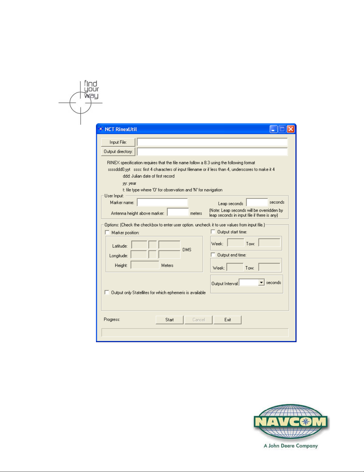
Overview of the RINEX Utility
The RINEX Utility converts NCT (NavCom Technology) binary raw data (0xB0, 0xB1,
and 0x44 messages) to RINEX v2.1 format. Converting NCT raw data to RINEX
provides a means to post-process the raw data where third party software packages do
not support the NCT Binary format, but do possess the ability to import RINEX Standard
measurement data.
Figure 1: NavCom RINEX Utility
The NCT RINEX converter utility GUI is divided into four major areas:
• File I/O
• User Input
• Options
• Execution and Progress
1
Page 10

File I/O
RINEX Utility – Rev B
Click the Input File button to navigate your way to the file path of the source NCT Binary
files. A Windows
®
dialog box, similar to Figure 2, will open. Locate the “.dat” extension
files in the appropriate source directory. This tells the RINEX utility where to get your
data from.
Figure 2: Input File Dialog
After selecting the file to convert, click the Open button.
2
Page 11

RINEX Utility – Rev B
RINEX requires the file naming convention to follow a specific format. The easiest way to
relate files is to use the same name convention for all related files in a given directory
and to use separate directors for files recorded on the same date. The file naming
convention is as follows:
9 File names are limited to 8 characters followed by a 3 character extension (MS-DOS
compatible; ssssddd0.yyt)
9 ssss = a unique file identifier. All four characters must be used. If less than 4
characters are used, enter “_” (underscore) to fill the space. Any alpha-numeric
character is acceptable (A-Z and 0 -9)
9 ddd = the julian date of the year; i.e. March 23, 2007 = julian date 082
9 0 = required fill character
9 yy = last two digits of the calendar year
9 t = file type; the output files will be tagged as either O for observation or N for
navigation
In a similar fashion, the Output Directory button tells the RINEX Utility where to place
the converted files when the process is complete. Most users create a sub-directory in
their data folder, so that related data sets stay together. Set the path to the folder where
the converted files are to be placed. Figure 3 depicts a typical window display.
Figure 3: Output File Dialog
3
Page 12

RINEX Utility – Rev B
After selecting a location to save the RINEX files, click OK.
Options are not always necessary to complete the conversion. Entering User Input or
Option data updates the RINEX header with user specific information. To skip the
Options menu, simply click the START button and the RINEX files will be generated
without any USER INPUT data or OPTIONS being entered, however the RINEX
observations file header will only show the default information shown in Table 1.
User Input
Figure 3 depicts the User Input area of the RINEX Utility. Completing these fields is
optional. Entries in these fields will be included in the RINEX observations or ephemeris
file header.
Marker name: This field allows up to 60 characters to identify the site where the
data was collected.
Leap seconds: This field allows the user to insert the current GPS Leap Second
value, if known. If left blank no leap second value will be reported in the
RINEX ephemeris (navigation) file header, or the RINEX Utility will use
the leap second time reported in the raw data file (if one exists). If the raw
data file has a larger leap second value reported than the user entered
value, the raw data file value will be used instead.
Antenna height above marker: This field allows the user to insert antenna base height
above the survey point. This adjustment can often be made in the Post Processing
Software package as well.
Figure 4: RINEX Converter User Input Area
4
Page 13

RINEX Utility – Rev B
Options
Figure 5 depicts the Options area of the RINEX Utility. To modify an option, the box
above and/or to the left must be “checked” (9).
Marker Position: When enabled, allows the user to input the Latitude,
Longitude, and Height of the surveyed position in Degrees Minutes and
Seconds. These coordinates are converted to Cartesian ECEF format
and inserted into the “Approximate Position XYZ” area of the RINEX
observation file. If left disabled, the RINEX Utility will average the position
based on the range measurements received from the total number of
epochs in the data collection period.
RINEX Utility conforms to RINEX Standard 2.10, which states that the Cartesian
ECEF position in the observation file header is WGS84. This means that the height
entered in the RINEX Utility must be WGS84. The RINEX Utility makes no attempt to
convert other datum heights to WGS84. Using height data from a datum other than
WGS84 will result in errors in the Z-axis.
Output start time / Output end time: When enabled, the Output Start and
Output End times allow the user to parse a large raw data file into a
smaller snap shot of the overall data collection period.
Caveats are that the GPS week number (0 – 1023), and the GPS Time Of
Week (TOW in seconds 0 – 604800) be entered. If disabled, the RINEX
Utility will process the entire data collection period.
Ephemeris Output: When enabled, outputs the ephemeris (navigation) file, but
only ephemeris data for those satellites that have been tracked over the
data collection period. If disabled the ephemeris file will contain data on
all satellites.
Figure 5: RINEX Converter Options Area
5
Page 14

RINEX Utility – Rev B
Leap Seconds 0 or Last Entered
Marker Name None or Last Entered
Antenna Height 0.0 or Last Entered
Marker Position Disabled
Output Times (Start and End) Disabled
Sat Ephemeris when Available Disabled
Table 1: RINEX Utility Defaults
Execution and Progress
The Start button engages the conversion process, which can be stopped at any time by
clicking the Cancel button. The Exit button will close the utility at any time including
during program execution, thereby canceling the process.
The Progress Bar provides graphical reassurance of utility progress, once the
conversion begins.
Figure 6: RINEX Converter Execute & Progress
6
Page 15

RINEX Utility – Rev B
Known Issues
RINEX will not process output files consecutively
When RINEX has finished processing a data file, the user cannot click start again
to begin processing the same or a different data set. Halfway through the
process the utility will display an error box “No Valid Observation Available”.
Resolution: Close the session of RINEX after processing each data set.
Position Is Incorrect When Entering a Marker Position
When the user manually enters a Marker Position into RINEX, the resulting OBS
file’s XYZ Positions are incorrect.
Resolution: Uncheck the Marker Position and allow the program to be run at
default. Fixed in next release.
7
 Loading...