

Page 1
US and Foreign Patents Granted and Pending. Fullpower®, TapTap®, and ShakeShake® are registered trademarks of Fullpower Technologies, Inc.
MotionX™, Touch-N-Set™, Tilt ‘n Roll™, and TiltTilt™ are trademarks of Fullpower Technologies, Inc.All other trademarks remain the property of
their respective owners. © Copyright 2003-2010 Fullpower Technologies, Inc. All rights reserved.
1
User Manual
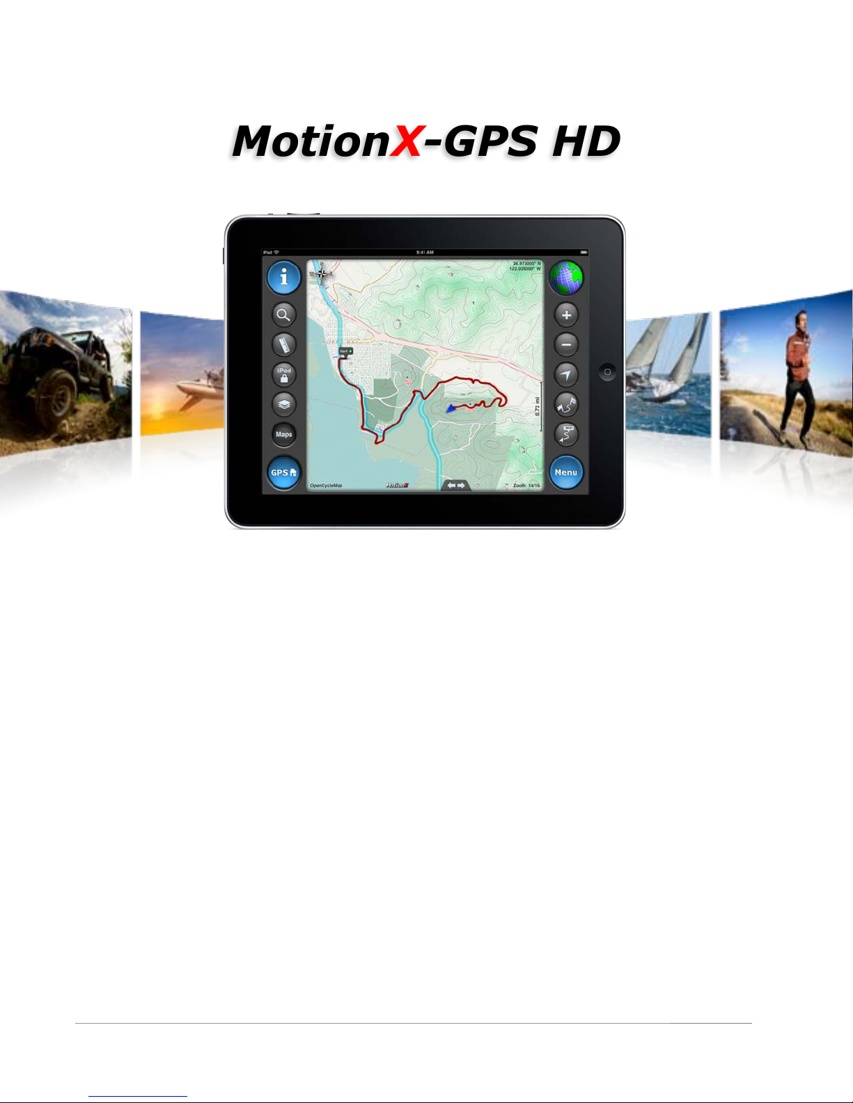
MotionX-GPS HD
Revision 13.0
November 2010
Fullpower Technologies, Inc., makers of MotionX™
Page 2

Table of Contents
US and Foreign Patents Granted and Pending. Fullpower®, TapTap®, and ShakeShake® are registered trademarks of Fullpower Technologies, Inc.
MotionX™, Touch-N-Set™, Tilt ‘n Roll™, and TiltTilt™ are trademarks of Fullpower Technologies, Inc.All other trademarks remain the property of
their respective owners. © Copyright 2003-2010 Fullpower Technologies, Inc. All rights reserved.
2
1. Overview 3
2. Menu 4
3. My Position Details 5
4. Track Recorder 6
5. Tracks 7
6. View on Map 9
7. Navigation Instruments 16
8. Search 18
9. Share 21
10. Map Downloads 23
11. Waypoints 27
12. Settings 29
!
Page 3
1. Overview
US and Foreign Patents Granted and Pending. Fullpower®, TapTap®, and ShakeShake® are registered trademarks of Fullpower Technologies, Inc.
MotionX™, Touch-N-Set™, Tilt ‘n Roll™, and TiltTilt™ are trademarks of Fullpower Technologies, Inc.All other trademarks remain the property of
their respective owners. © Copyright 2003-2010 Fullpower Technologies, Inc. All rights reserved.
3
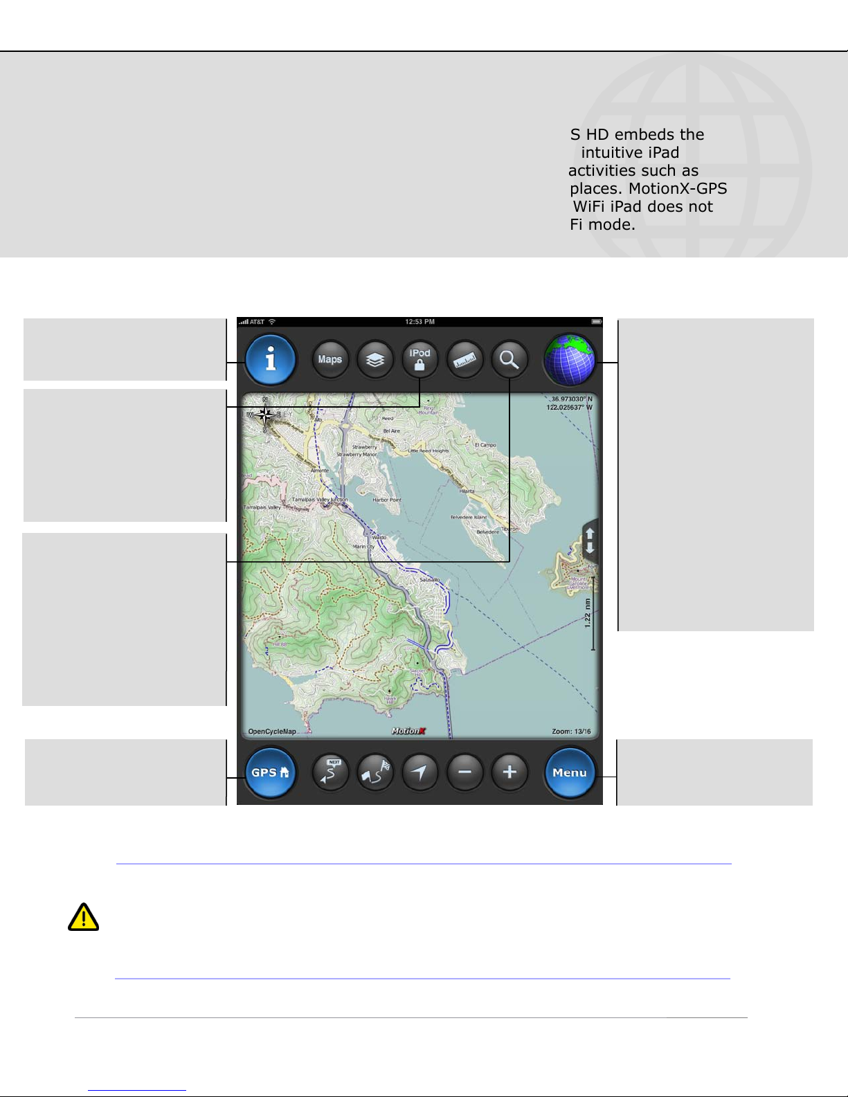
The most accurate and reliable solution for the iPad, MotionX-GPS HD embeds the
functionality of an advanced handheld GPS unit into a simple and intuitive iPad
application. Use MotionX-GPS HD with your iPad during outdoor activities such as
hiking, sailing, off-roading, flying, geocaching, or exploring new places. MotionX-GPS
HD is exclusively designed and optimized for the iPad. While the WiFi iPad does not
contain a GPS chipset, many of the features are still useful in WiFi mode.
Info: Access the in-app
help file from any page.
iPod/lock: Access iPod
controls from any page;
the control panel slides
up and down in when this
button is touched. The
screen lock is also found
in this control panel.
Search: Perform a search
to find the geocoded
location, including:
•
Country name (e.g.
“Italy”)
•
Landmark (e.g. “Mount
Everest”)
•
Address
•
Lat / Lon
GPS signal indicator.
Touch to toggle modes.
GPS: Outdoor GPS mode
(3G iPad only). Accuracy
30-300 feet.
Wifi: Approximate
position using Wifi or
network triangulation.
Accuracy 100 feet to 3
miles.
Manual: Offline mode;
not searching for signal.
Manually enter your
position, no real-time
location information.
GPS home: Quickly
access the Map screen
from any page.
GPS requires a direct “line-of-sight” to communicate with satellites. Your 3G
iPad must have a clear view of the sky to locate at least three satellites in order
to give accurate position information. If you are indoors, in a wooded area,
surrounded by buildings, or in the back seat of your car, for example, you may
be unable to acquire an accurate GPS signal.
Menu: Return to the
main menu from any
page.
Page 4
2. Menu
US and Foreign Patents Granted and Pending. Fullpower®, TapTap®, and ShakeShake® are registered trademarks of Fullpower Technologies, Inc.
MotionX™, Touch-N-Set™, Tilt ‘n Roll™, and TiltTilt™ are trademarks of Fullpower Technologies, Inc.All other trademarks remain the property of
their respective owners. © Copyright 2003-2010 Fullpower Technologies, Inc. All rights reserved.
4
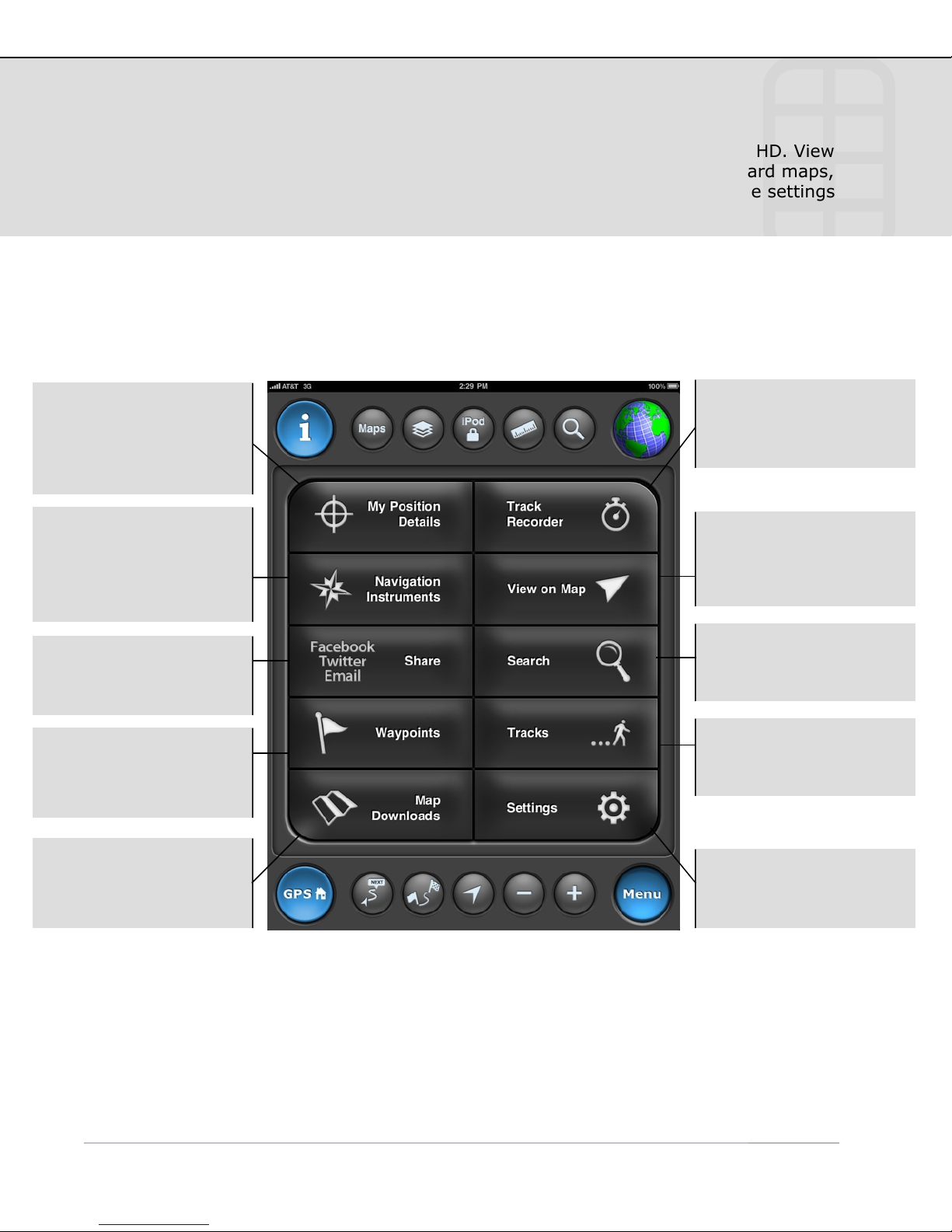
The MotionX Menu provides access to the various capabilities of MotionX-GPS HD. View
and mark your current position, navigate to a waypoint, view and store onboard maps,
access your saved waypoints, view the navigation instruments, and access the settings
from this page.
Each menu button is explained here briefly. Additional details for each function are
outlined in the subsequent sections of this manual.
My Position Details:
View current position,
create a waypoint, view
signal strength and
accuracy.
Navigation
Instruments: Current
heading, SOG, VMG,
ETA, waypoint distance
& bearing to wypt.
Share: Share your tracks
and waypoints via email,
facebook, or twitter.
Waypoints: View a list
of your saved waypoints;
view GPX file import
instructions.
Track Recorder: Open
the GPS stopwatch to
record a track.
View on Map: View
maps, with tracks,
waypoints, and optional
gridlines overlaid.
Navigate To: Select a
location to which you
want to navigate.
Tracks: View a list and
details of your saved
tracks.
Map Downloads:
Download maps for
offline use.
Settings: Access the
various user-based
settings and controls.
Page 5
3. My Position Details
US and Foreign Patents Granted and Pending. Fullpower®, TapTap®, and ShakeShake® are registered trademarks of Fullpower Technologies, Inc.
MotionX™, Touch-N-Set™, Tilt ‘n Roll™, and TiltTilt™ are trademarks of Fullpower Technologies, Inc.All other trademarks remain the property of
their respective owners. © Copyright 2003-2010 Fullpower Technologies, Inc. All rights reserved.
5
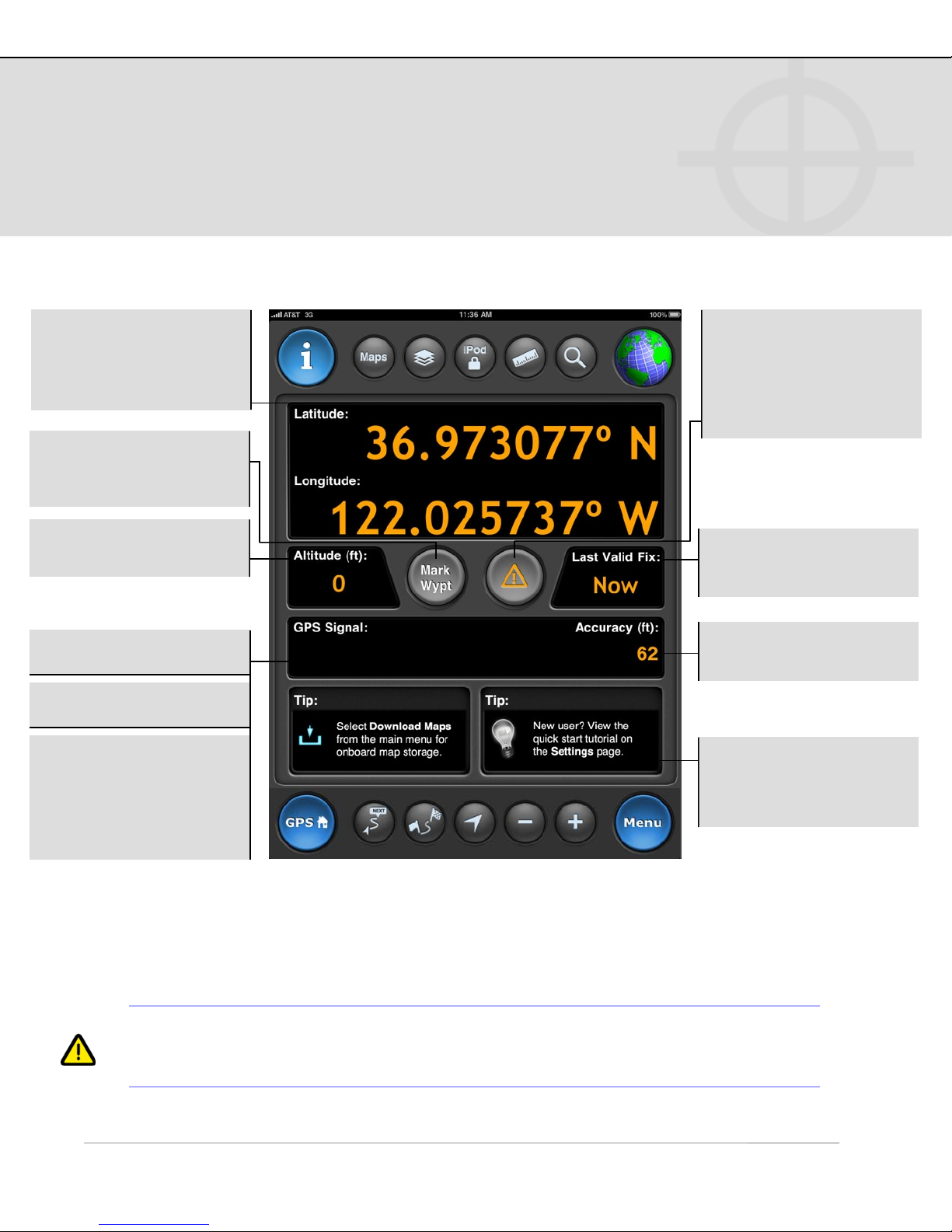
Quickly view your current geographic location, altitude, and GPS signal strength from
the My Position Details page. Create a waypoint to mark your current position with one
click. Use the emergency button to mark your position and start navigating back to it.
Lat/Lon: Current
location. Choose between
Lat/Lon, UTM and MGRS
coordinate systems.
Mark Wypt: Create a
new waypoint using your
current position.
Altitude: Current
altitude (feet or meters).
GPS Signal:
Green: Strong signal.
Yellow: Average signal.
Red: Weak signal;
position information
may be inaccurate/
unreliable. A question
mark will appear in the
position data fields.
1
Emergency: Mark your
current position and
initiate navigation back
to this point. Useful for
man-overboard type
situations.
Last Valid Fix: Elapsed
time since the last valid
location point.
Accuracy: Horizontal
accuracy.
Tips/Links: Tips and
links to help you learn
more about MotionX-GPS
HD.
1
“Wifi/Triangulation” indicates your iPad is using network triangulation to
estimate your position. Location values may be inaccurate by several hundred
feet up to a few miles.
Page 6
4. Track Recorder
US and Foreign Patents Granted and Pending. Fullpower®, TapTap®, and ShakeShake® are registered trademarks of Fullpower Technologies, Inc.
MotionX™, Touch-N-Set™, Tilt ‘n Roll™, and TiltTilt™ are trademarks of Fullpower Technologies, Inc.All other trademarks remain the property of
their respective owners. © Copyright 2003-2010 Fullpower Technologies, Inc. All rights reserved.
6
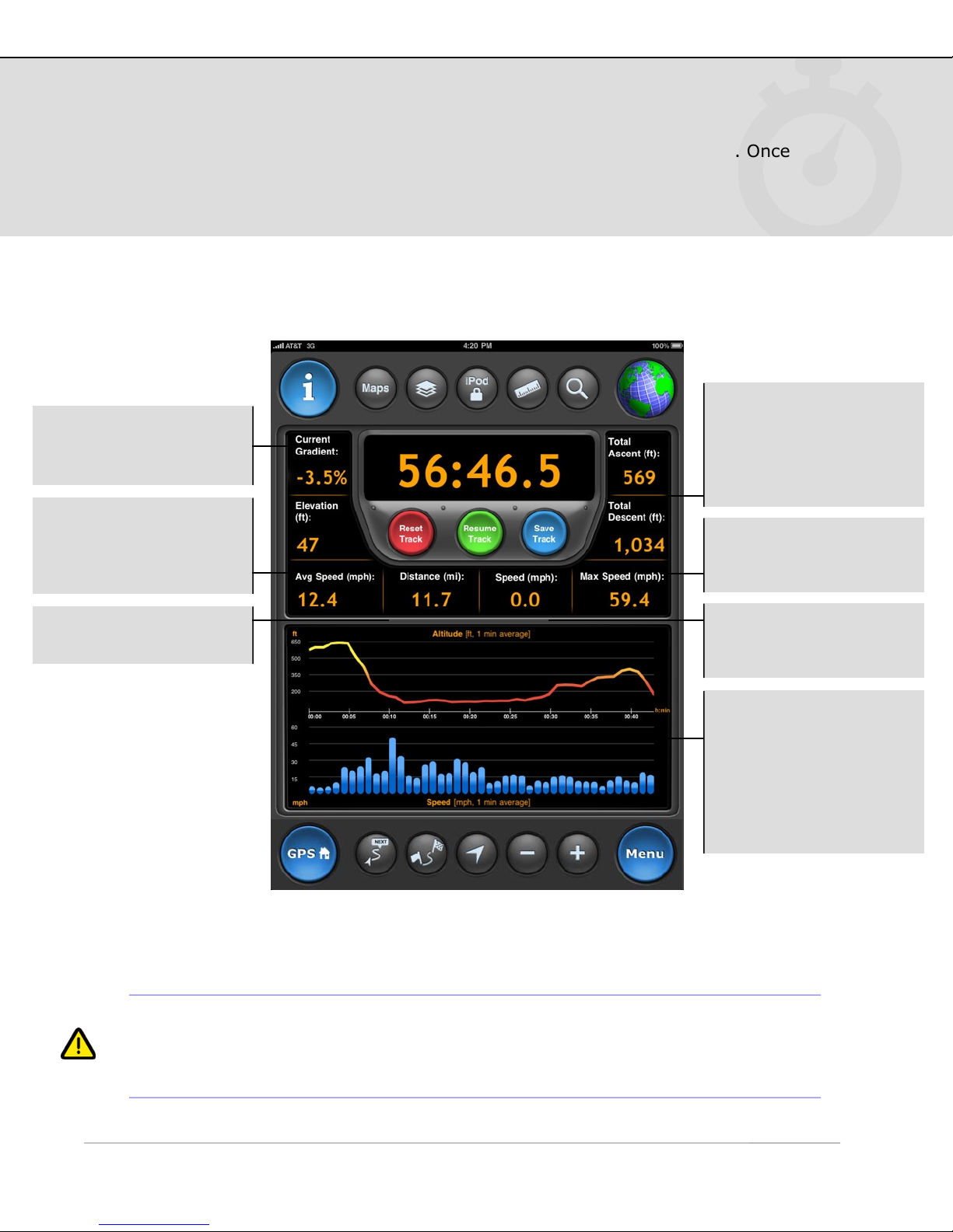
Record a track of your hikes, drives, flights, sails or other outdoor activities. Once
saved, the track is added to the Tracks log.
Gradient: Current
gradient (based on
change in altitude).
Avg Speed: Average
speed or pace; select
units preference in
Settings.
Ascent Descent: Total
ascent / descent over the
course of your track
(based on changes in
altitude).
Max Speed: Maximum
speed achieved over the
course of your track.
Distance: Total recorded
track distance.
Speed: Current speed of
travel; select units
preference in Settings.
Graphs: Speed and
altitude graphs are
populated after the track
is initiated. Graphs are
updated once per
minute; each interval is
an average over the past
minute of travel.
! For the Wifi-only iPad, distance and speed values may be inaccurate due to the
fact that location accuracy is only between 100 feet and 3 miles in Wifi mode. A
reliable GPS signal (indicated by a blue spinning globe) is required for accurate
results.
Page 7
5. Tracks
US and Foreign Patents Granted and Pending. Fullpower®, TapTap®, and ShakeShake® are registered trademarks of Fullpower Technologies, Inc.
MotionX™, Touch-N-Set™, Tilt ‘n Roll™, and TiltTilt™ are trademarks of Fullpower Technologies, Inc.All other trademarks remain the property of
their respective owners. © Copyright 2003-2010 Fullpower Technologies, Inc. All rights reserved.
7
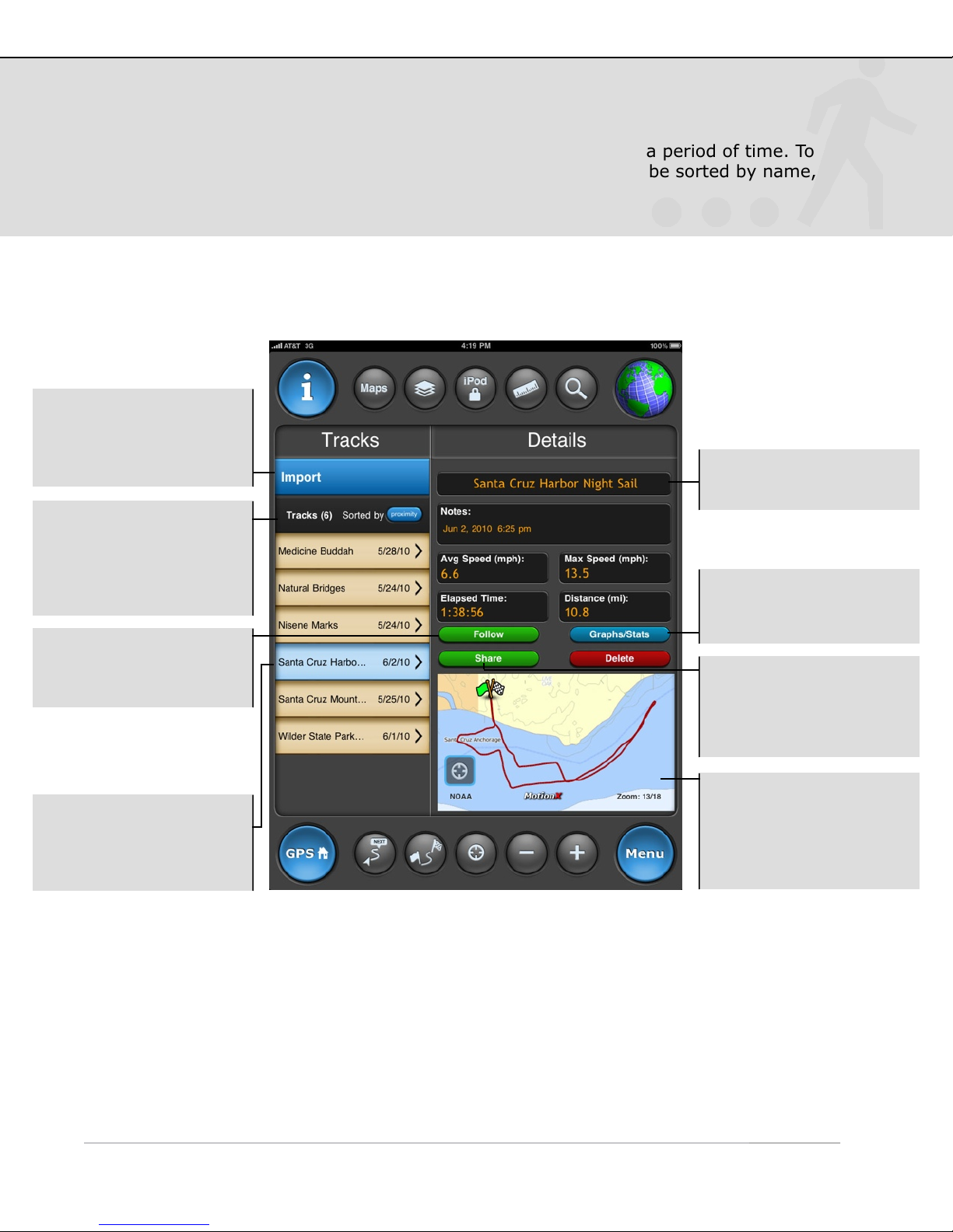
A track is a compilation of samples or “breadcrumbs” taken over a period of time. To
record and save your tracks, use the Track Recorder. The list can be sorted by name,
date, or proximity.
Import: View
instructions for importing
tracks (GPX file format)
into MotionX-GPS HD.
Track List: View all of
your saved tracks. Sort
by date, proximity, or
name. Save up to 101
tracks.
Follow: view this route
overlaid on the Maps
page for easy following.
Touch the track name to
edit.
Graph/Stats: View the
speed and altitude graphs
for the selected track.
Share: Share the
selected track via email,
facebook, and/or twitter.
See the Share section of
this manual for details.
Select a track to see an
overview, including the
name, details, and an
overview of your route.
Map: The map type in
the preview pane
matches the map type
you have selected on the
Maps page.
Page 8
5. Tracks (continued)
US and Foreign Patents Granted and Pending. Fullpower®, TapTap®, and ShakeShake® are registered trademarks of Fullpower Technologies, Inc.
MotionX™, Touch-N-Set™, Tilt ‘n Roll™, and TiltTilt™ are trademarks of Fullpower Technologies, Inc.All other trademarks remain the property of
their respective owners. © Copyright 2003-2010 Fullpower Technologies, Inc. All rights reserved.
8
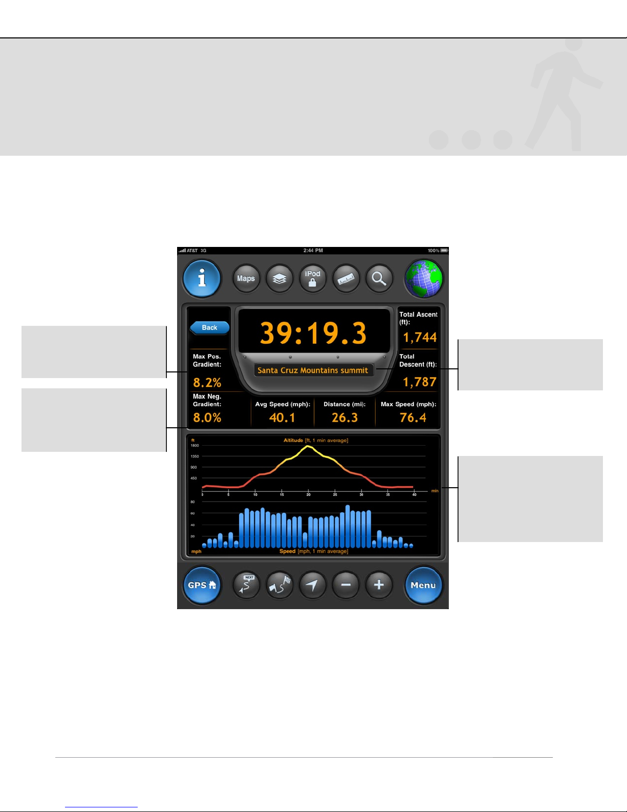
Track Details
Gradient: Maximum and
minimum gradient
recorded.
Name: Displays the
name you have chosen
for the track.
Avg Speed: Average
speed or pace; display
depends on Settings
preferences.
Graphs: Altitude and
speed as a function of
time. Each one minute
interval is an average
over the past minute of
travel.
!
Page 9

6. View on Map
US and Foreign Patents Granted and Pending. Fullpower®, TapTap®, and ShakeShake® are registered trademarks of Fullpower Technologies, Inc.
MotionX™, Touch-N-Set™, Tilt ‘n Roll™, and TiltTilt™ are trademarks of Fullpower Technologies, Inc.All other trademarks remain the property of
their respective owners. © Copyright 2003-2010 Fullpower Technologies, Inc. All rights reserved.
9
The MotionX Map view shows your position and a track of your movement. Choose
from ten different map types, including road, aerial, hybrid, terrain, and marine.
Optionally display your waypoints and a coordinate grid overlay, use the distance tool
to measure distance and bearing, and search for an address with the search tool.
Waypoint markers:
Waypoint saved as
your Home.
Saved point of
interest.
Arrows:
Start Nav
Waypoint
Navigation to a
waypoint started.
Waypoint to which
you are navigating.
Initial position at
app launch.
Waypoint
markers; shape
depends on the
number of
waypoints in the
current field of
1
view.
1
If there are 21 or more waypoints or POIs in view, they will be displayed as
dots. Between 11-20, pins are used. If ten or fewer, rectangular signs are
displayed.
Current position;
good GPS signal.
“Headlight” indicates
direction up mode.
Position estimated with
Wifi or network
triangulation.
Weak GPS signal
(borderless blue circle).
Position unknown; no
location signal.
Use the MotionX TapTap™ tool to create a new waypoint on the map. Move the
map or change zoom levels to position the marker. As the map is moved, the
coordinates of the waypoint as well as the range and bearing from your current
location are displayed at the lower right of the map.
Page 10
6. View on Map (continued)
US and Foreign Patents Granted and Pending. Fullpower®, TapTap®, and ShakeShake® are registered trademarks of Fullpower Technologies, Inc.
MotionX™, Touch-N-Set™, Tilt ‘n Roll™, and TiltTilt™ are trademarks of Fullpower Technologies, Inc.All other trademarks remain the property of
their respective owners. © Copyright 2003-2010 Fullpower Technologies, Inc. All rights reserved.
10
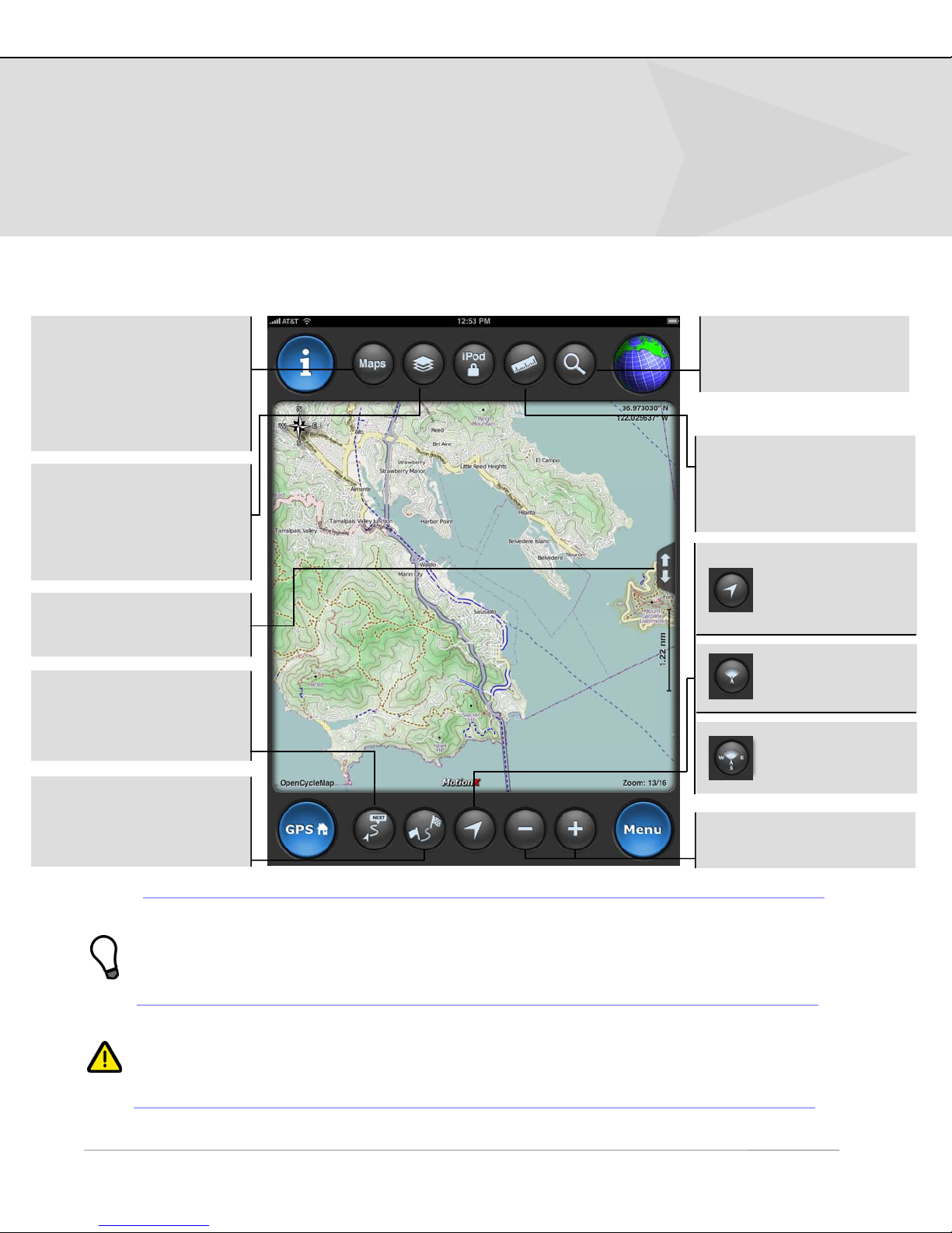
Map Controls
Maps: Select your
preferred map type.
Includes several options
for road, terrain,
satellite, hybrid, and
marine charts.
Layers: Select what
elements are displayed
on the map: choose to
display gridlines, tracks,
and/or waypoints.
Full screen: View the
map in full screen mode.
Position along Track:
Zoom/center the map
around your current
track & current position.
Search: Perform a
search to find the
geocoded location.
1
Distance: Measure the
distance and bearing
between any two points
on the map.
Touch to center
the map around
your current
position.
Position centered;
course up.
2
Position centered;
direction-up.
Position to Waypoint:
Zoom/center the map
around your current
position and destination.
1
Enter an address, location, or Lat/Lon and save the search result as a
3
waypoint. Then initiate navigation to this point with one click. Location entry
may include the name of a landmark (”Mount Everest”), a park (”Yosemite”), or
a point of interest (”Golden Gate Bridge”), for example.
2
Functional only while actively recording a track; centers around the red colored
tracks on the map. Otherwise the functionality is identical to the crosshairs.
3
!
Functional only while actively navigating to a destination.
+ / - : Zoom in & out.
Page 11
6. View on Map (continued)
US and Foreign Patents Granted and Pending. Fullpower®, TapTap®, and ShakeShake® are registered trademarks of Fullpower Technologies, Inc.
MotionX™, Touch-N-Set™, Tilt ‘n Roll™, and TiltTilt™ are trademarks of Fullpower Technologies, Inc.All other trademarks remain the property of
their respective owners. © Copyright 2003-2010 Fullpower Technologies, Inc. All rights reserved.
11
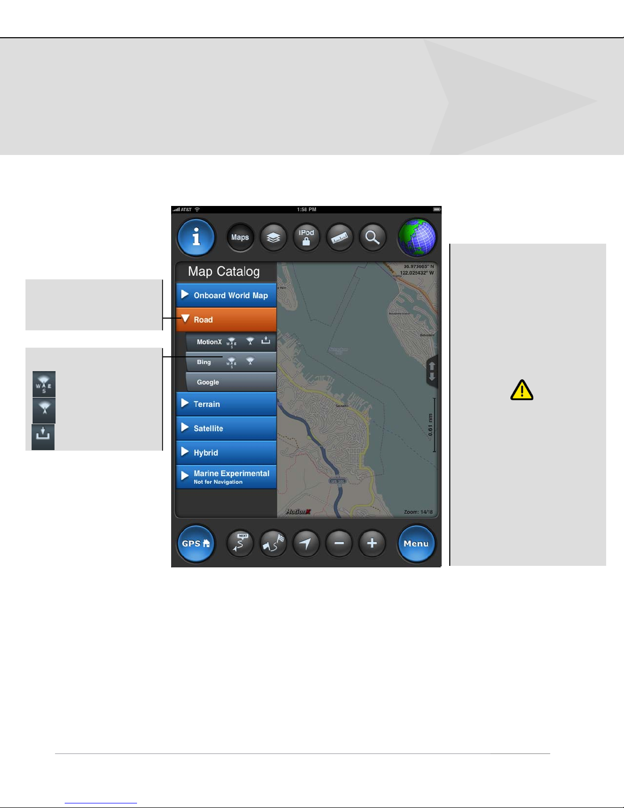
Map Catalog
Expand the map type to
see the various
sources.
Map Options:
Map sources:
• MotionX: road, terrain;
uses OpenStreetMap data.
• Bing: road, aerial, hybrid.
• Google: road, aerial,
hybrid.
• NOAA: marine (U.S. only).
Direction-up.
Course-up.
Onboard storage.
Due to Microsoft
restrictions on Bing maps
and Google restrictions
on Google maps, these
maps types can’t be
cached or stored
onboard. By contrast,
MotionX road and terrain
maps, and NOAA marine
charts may be cached
and stored onboard. See
the Download Maps
section for details.
Map types:
• Auto Up: rotates the underlying map to maintain an upward heading. Uses Direction Up (magnetic
compass) below 5 mph and Course Up (GPS orderly changes in position) above 5 mph. This feature
is not available for Google Maps.
• Direction Up: rotates the underlying map to maintain an upward heading, using the magnetic
compass. This feature is not available for Google Maps.
• Course Up: uses orderly changes in position from satellite data to rotate the map to maintain an
upward heading. Speed of travel must be more than a few mph (or km/h). This feature is not
available for Google Maps.
• North Up: displays the map with North at the top.
!
Page 12
6. View on Map (continued)
US and Foreign Patents Granted and Pending. Fullpower®, TapTap®, and ShakeShake® are registered trademarks of Fullpower Technologies, Inc.
MotionX™, Touch-N-Set™, Tilt ‘n Roll™, and TiltTilt™ are trademarks of Fullpower Technologies, Inc.All other trademarks remain the property of
their respective owners. © Copyright 2003-2010 Fullpower Technologies, Inc. All rights reserved.
12
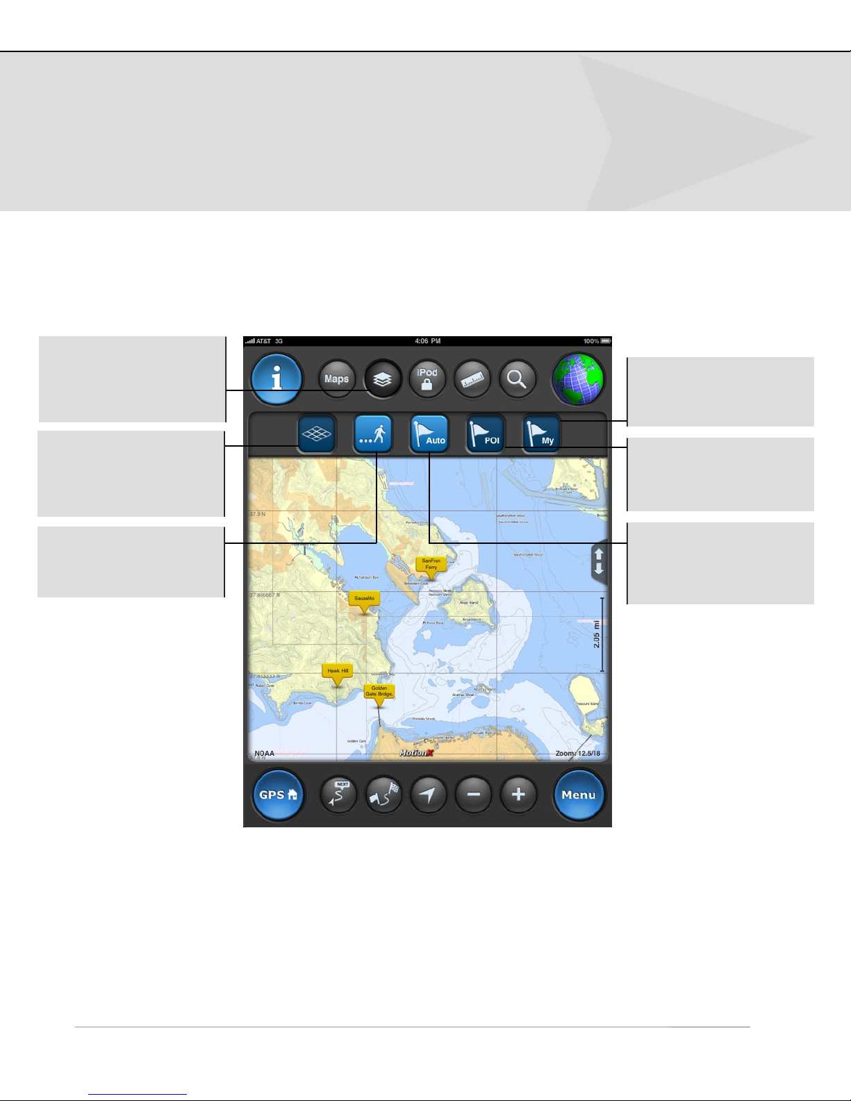
Map Layers
The Layers button
controls what elements
are displayed on the
map.
My: Toggles the display
of your saved waypoints
on the map on/off.
Grid: Toggles the
display of a coordinate
grid: Lat/Lon, UTM, or
MGRS.
Tracks: Toggles the
display of tracks on the
map on/off.
POI: Toggles the
display of your saved
waypoints on the map
on/off.
Auto: Toggles the
display of Points of
Interest waypoints on
the map on/off.
!
Page 13
6. View on Map (continued)
US and Foreign Patents Granted and Pending. Fullpower®, TapTap®, and ShakeShake® are registered trademarks of Fullpower Technologies, Inc.
MotionX™, Touch-N-Set™, Tilt ‘n Roll™, and TiltTilt™ are trademarks of Fullpower Technologies, Inc.All other trademarks remain the property of
their respective owners. © Copyright 2003-2010 Fullpower Technologies, Inc. All rights reserved.
13
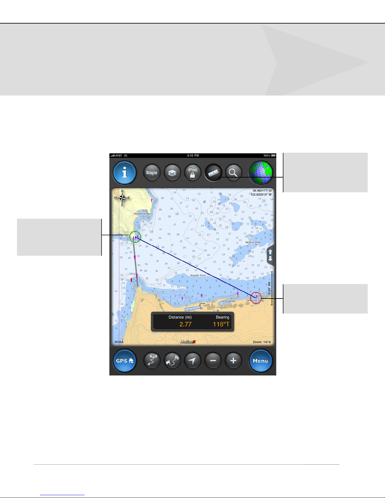
Distance Tool
The green crosshairs
represents the starting
point (from which the
bearing is computed.)
Use the Distance Tool to
measure distance and
bearing between any
two points on the map.
The red crosshairs
represents the end
point.
!
Page 14
6. View on Map (continued)
US and Foreign Patents Granted and Pending. Fullpower®, TapTap®, and ShakeShake® are registered trademarks of Fullpower Technologies, Inc.
MotionX™, Touch-N-Set™, Tilt ‘n Roll™, and TiltTilt™ are trademarks of Fullpower Technologies, Inc.All other trademarks remain the property of
their respective owners. © Copyright 2003-2010 Fullpower Technologies, Inc. All rights reserved.
14
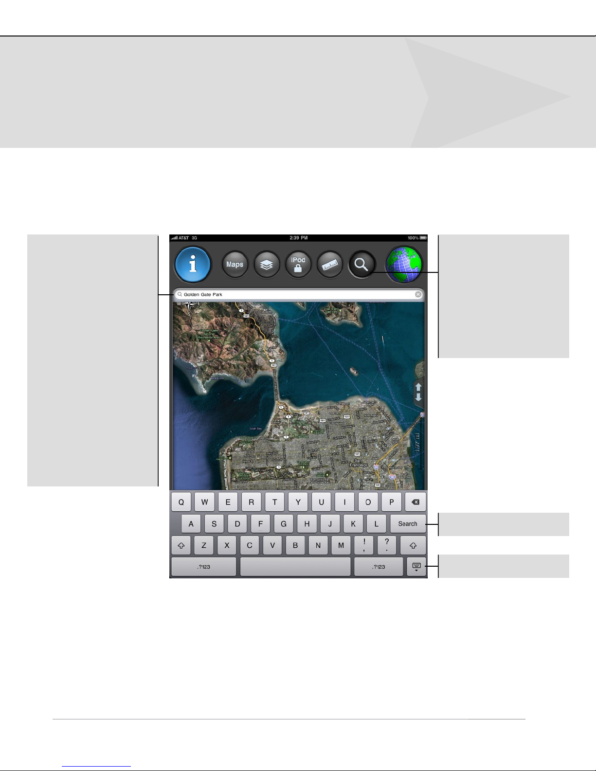
Search
Search queries may
include the following
input formats:
•
Country name, for
example “France”.
•
Location or landmark,
for example “Golden
Gate Park” or “Mount
Everest”.
•
Address, options:
-
full address
-
city name
-
state/province
-
zip/postal code
•
Lat / Lon, for example
“41.89 N, 87.61 W”.
Search: Perform a
search to find the
geocoded location.
A waypoint will be
created to identify the
location; the Notes field
will be auto-populated
with your search query
input.
Initiate search.
!
Hide the keyboard.
Page 15

6. View on Map (continued)
US and Foreign Patents Granted and Pending. Fullpower®, TapTap®, and ShakeShake® are registered trademarks of Fullpower Technologies, Inc.
MotionX™, Touch-N-Set™, Tilt ‘n Roll™, and TiltTilt™ are trademarks of Fullpower Technologies, Inc.All other trademarks remain the property of
their respective owners. © Copyright 2003-2010 Fullpower Technologies, Inc. All rights reserved.
15
Track Types
A solid blue line traces your path when a GPS signal is active. When
using WiFi mode, a solid blue line plots a path between WiFi access
points.
A dotted blue line represents an interpolated path between two points
when signal has been lost.
A solid red line represents your path while recording a track with the
Track Recorder. Use the "Start Track", "Pause Track" and "Save Track"
controls on the MotionX-Track Recorder page to record and save your
track.
A dotted red line represents an interpolated path between two points
when signal has been lost.
A dashed green line from the arrow indicates the path to the waypoint
you have chosen as your destination using the Start Nav button.
A solid orange line represents a previously recorded track that is being
followed. A green start flag indicates the start of the track and a
checkered end flag indicates the end.
!
Page 16
7. Navigation Instruments
US and Foreign Patents Granted and Pending. Fullpower®, TapTap®, and ShakeShake® are registered trademarks of Fullpower Technologies, Inc.
MotionX™, Touch-N-Set™, Tilt ‘n Roll™, and TiltTilt™ are trademarks of Fullpower Technologies, Inc.All other trademarks remain the property of
their respective owners. © Copyright 2003-2010 Fullpower Technologies, Inc. All rights reserved.
16
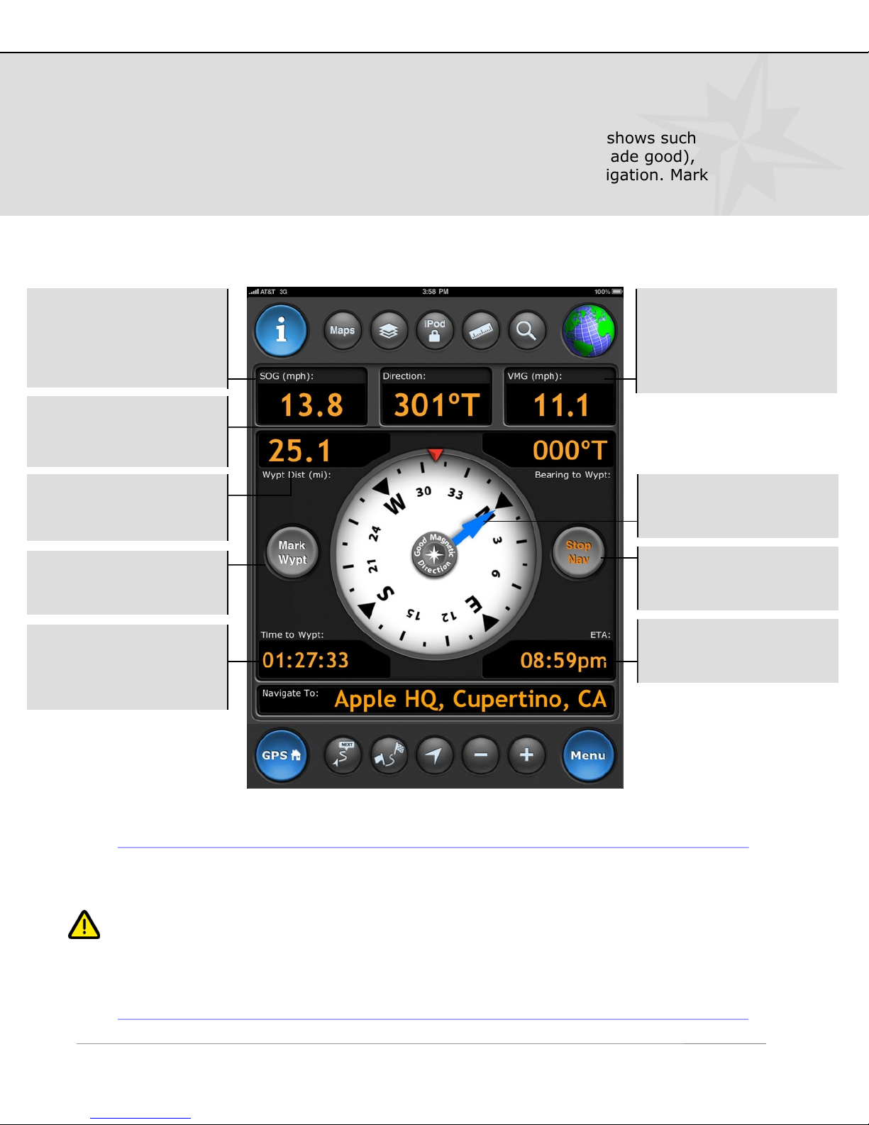
Leveraging the iPad’s built-in magnetometer, the MotionX compass shows such
information as heading, SOG (speed over ground), VMG (velocity made good),
distance, bearing, and time to waypoint, and ETA during active navigation. Mark
waypoints and start/stop navigation with a single touch.
SOG: Speed over
ground. The speed at
which you are moving
over the surface of the
earth.
Direction: Current
direction of travel; True
North (T) or Magnetic (M).
Wypt Dist: Distance
remaining to your
waypoint.
Mark Wypt: Create a
waypoint at your current
position.
Time to Wypt:
Estimated time remaining
until you arrive at your
waypoint.
VMG: Velocity made
good. Effective speed at
which you are
approaching your
waypoint.
Blue arrow: Indicates
the bearing to your
destination.
Nav button: Start or
stop navigating to a
waypoint.
ETA: Estimated time you
will arrive at your
destination.
For the satellite-based compass (GPS mode) to provide an accurate heading,
you should be outdoors with a clear view of the sky and moving at least a few
mph or km/h.
The magnetometer in the 3G iPad is susceptible to magnetic interference from
electronics and ferrous metals. If an accurate direction cannot be achieved due
to interference, you will be instructed to move away from the interference and
re-calibrate the magnetometer by moving your iPad in a figure 8 pattern.
Page 17
7. Navigation Instruments (continued)
US and Foreign Patents Granted and Pending. Fullpower®, TapTap®, and ShakeShake® are registered trademarks of Fullpower Technologies, Inc.
MotionX™, Touch-N-Set™, Tilt ‘n Roll™, and TiltTilt™ are trademarks of Fullpower Technologies, Inc.All other trademarks remain the property of
their respective owners. © Copyright 2003-2010 Fullpower Technologies, Inc. All rights reserved.
17
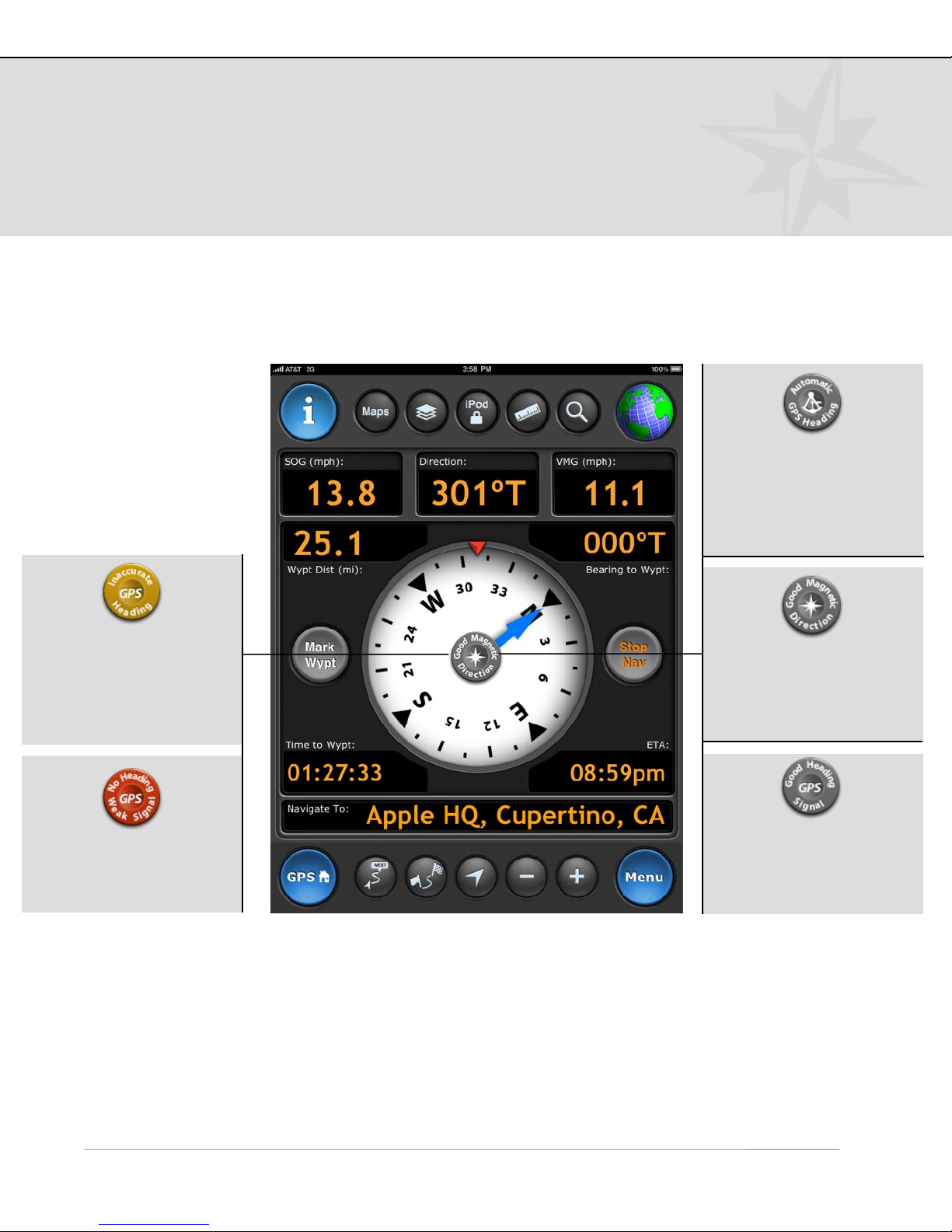
Compass Button
Compass Modes
(touch to toggle):
Auto Mode: Uses the
magnetometer at speeds
below 5 mph and GPS
positional changes above
5 mph. The icon is a
sextant.
Inaccurate heading:
Heading accuracy is
<85%. Sustain a speed
of more than a few mph
(or km/h) for an
accurate heading.
Weak GPS signal: Red
compass button indicates
weak or no GPS signal.
Magnetic Mode: Uses
the built-in digital
compass. The icon is a
compass rose (8-point
star).
GPS Mode: Heading is
determined using orderly
changes in position (GPS
signal required).
!
Page 18
8. Search
US and Foreign Patents Granted and Pending. Fullpower®, TapTap®, and ShakeShake® are registered trademarks of Fullpower Technologies, Inc.
MotionX™, Touch-N-Set™, Tilt ‘n Roll™, and TiltTilt™ are trademarks of Fullpower Technologies, Inc.All other trademarks remain the property of
their respective owners. © Copyright 2003-2010 Fullpower Technologies, Inc. All rights reserved.
18
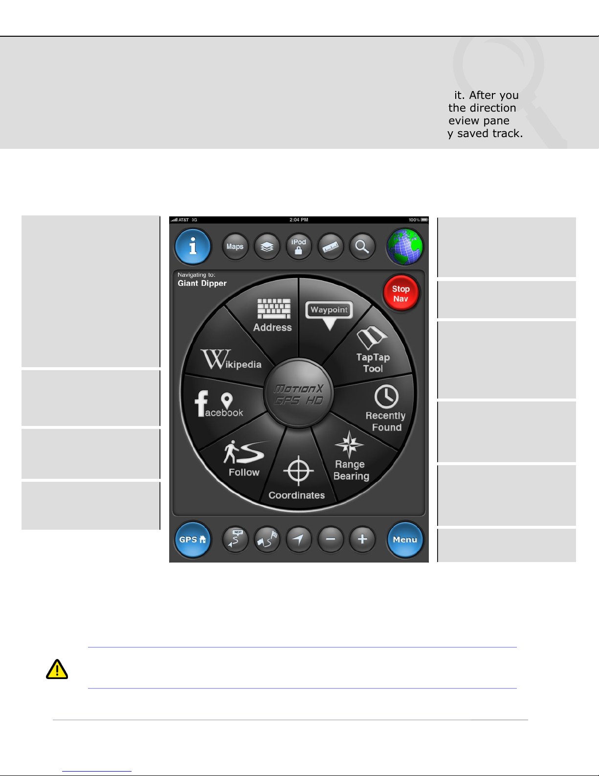
Define a destination waypoint using a variety of methods and navigate to it. After you
select a waypoint and start navigating, the Map screen appears showing the direction
and bearing to the waypoint. View your saved waypoints in a live map preview pane
prior to initiating navigation. There is also an option to follow a previously saved track.
Address input:
•
Country name.
•
Location or landmark,
e.g. “Mount Everest”.
•
Address, options:
-
full address
-
city name
-
state/province
-
zip/postal code
•
Lat / Lon, for example
“41.89 N, 87.61 W”.
Wikipedia: View POIs
around you or in a
specified location; read
the associated articles.
Facebook: View your
friends’ check-ins using
Facebook Places.
Follow: Follow one of
your saved tracks
(plotted on the map).
Stop Nav: This button
appears when you are
actively navigating.
Touch to end navigation.
Waypoint: Select from
your saved waypoints.
TapTap™ tool: Create a
new waypoint by tapping
twice on the map. A new
waypoint will be created
and saved.
Recently Found: View
your waypoints sorted by
date to quickly find
recently saved points.
Range/Bearing: Enter a
range (distance) and
bearing (degrees) from
your current position.
1
reflect these systems.
If UTM or MGRS is selected as the coordinate system, the input format will
Coordinates: Define the
waypoint coordinates.
1
Page 19
8. Search (continued)
US and Foreign Patents Granted and Pending. Fullpower®, TapTap®, and ShakeShake® are registered trademarks of Fullpower Technologies, Inc.
MotionX™, Touch-N-Set™, Tilt ‘n Roll™, and TiltTilt™ are trademarks of Fullpower Technologies, Inc.All other trademarks remain the property of
their respective owners. © Copyright 2003-2010 Fullpower Technologies, Inc. All rights reserved.
19
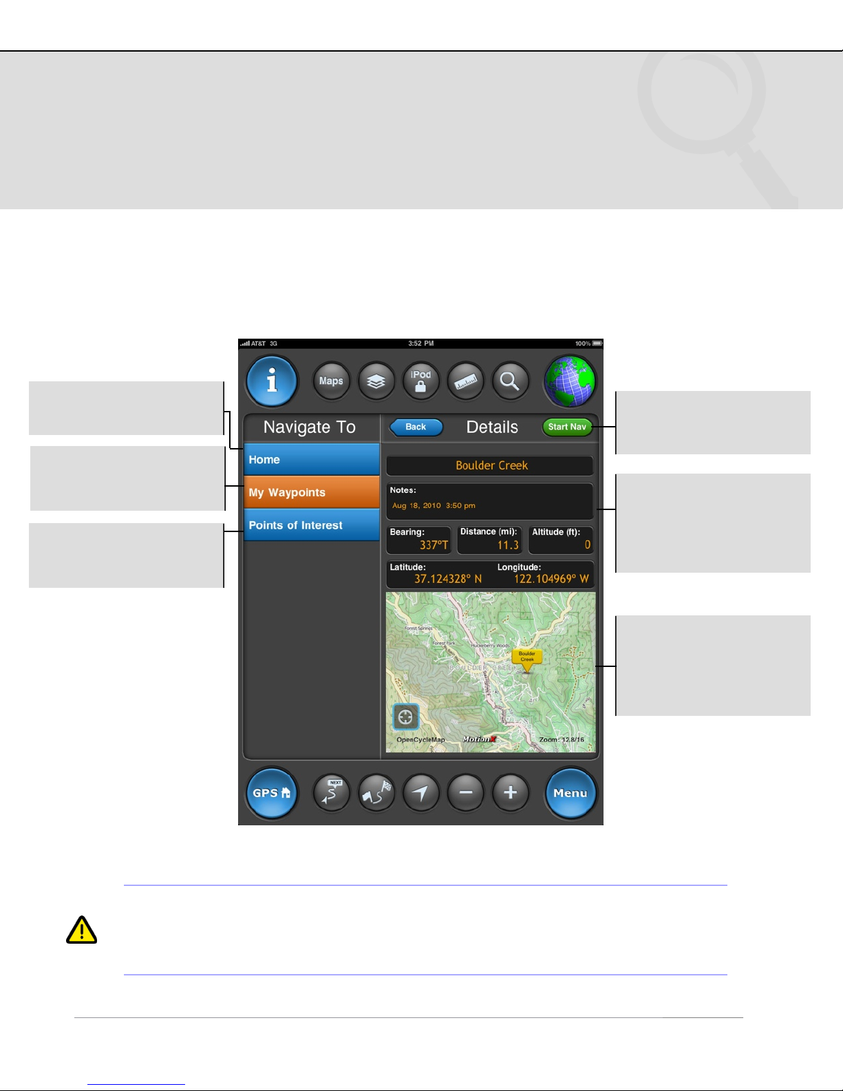
Navigate to Waypoint
Home: Navigate to the
point saved as “Home”.
My Waypoints: Select
from your list of saved
waypoints.
Points of Interest:
Select pre-loaded POIs
from around the world.
1
Start Nav: Initiate
navigation to the selected
waypoint.
Waypoint name, notes,
and lat/lon may be edited
in the same way it is
edited from the
Waypoints page.
View a preview of your
waypoint on the map.
The map type matches
your selected preference
on the Map page.
1
While using MotionX-GPS HD in manual mode (GPS and Wifi off), navigation to
a waypoint will begin from the location you have identified as your “Home”
waypoint. Edit the Home waypoint to change where navigation begins while
using manual mode.
!
Page 20
8. Search (continued)
US and Foreign Patents Granted and Pending. Fullpower®, TapTap®, and ShakeShake® are registered trademarks of Fullpower Technologies, Inc.
MotionX™, Touch-N-Set™, Tilt ‘n Roll™, and TiltTilt™ are trademarks of Fullpower Technologies, Inc.All other trademarks remain the property of
their respective owners. © Copyright 2003-2010 Fullpower Technologies, Inc. All rights reserved.
20
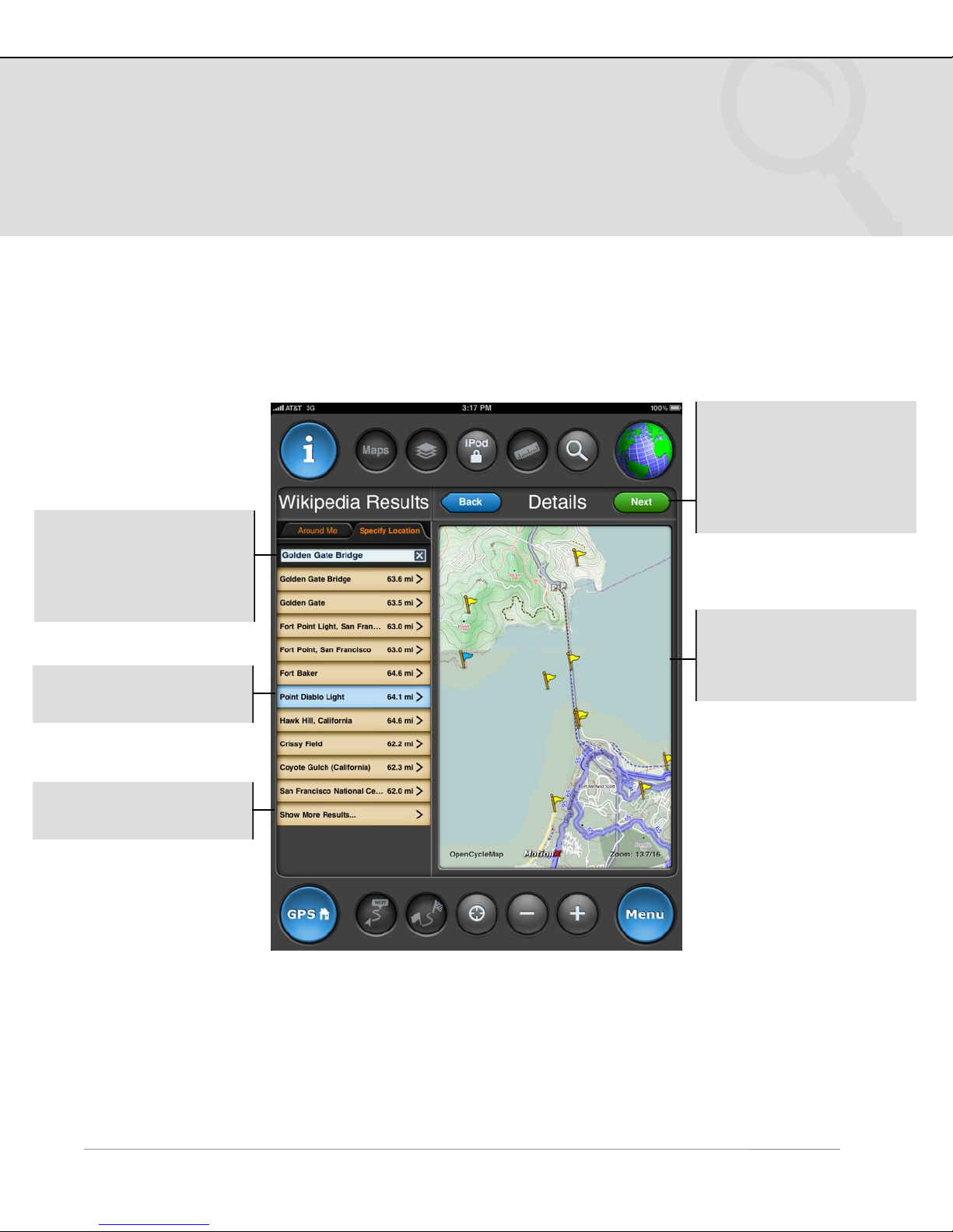
Wikipedia POI Search
Search the full catalog of Wikipedia articles that include coordinate information
(lat,lon). Access complete articles directly within MotionX-GPS HD.
Specify Location:
Define a location for your
search. This may be a
city or a landmark (e.g.
“Golden Gate Bridge”).
Select an entry or touch
a flag to select a POI.
Next: Read the Wikipedia
summary, and optionally
view the full article.
Initiate navigation to this
POI from the following
screen.
The map type will default
to your selected
preference from the Maps
menu.
Show More Results:
Expand the search radius.
!
Page 21
9. Share
US and Foreign Patents Granted and Pending. Fullpower®, TapTap®, and ShakeShake® are registered trademarks of Fullpower Technologies, Inc.
MotionX™, Touch-N-Set™, Tilt ‘n Roll™, and TiltTilt™ are trademarks of Fullpower Technologies, Inc.All other trademarks remain the property of
their respective owners. © Copyright 2003-2010 Fullpower Technologies, Inc. All rights reserved.
21
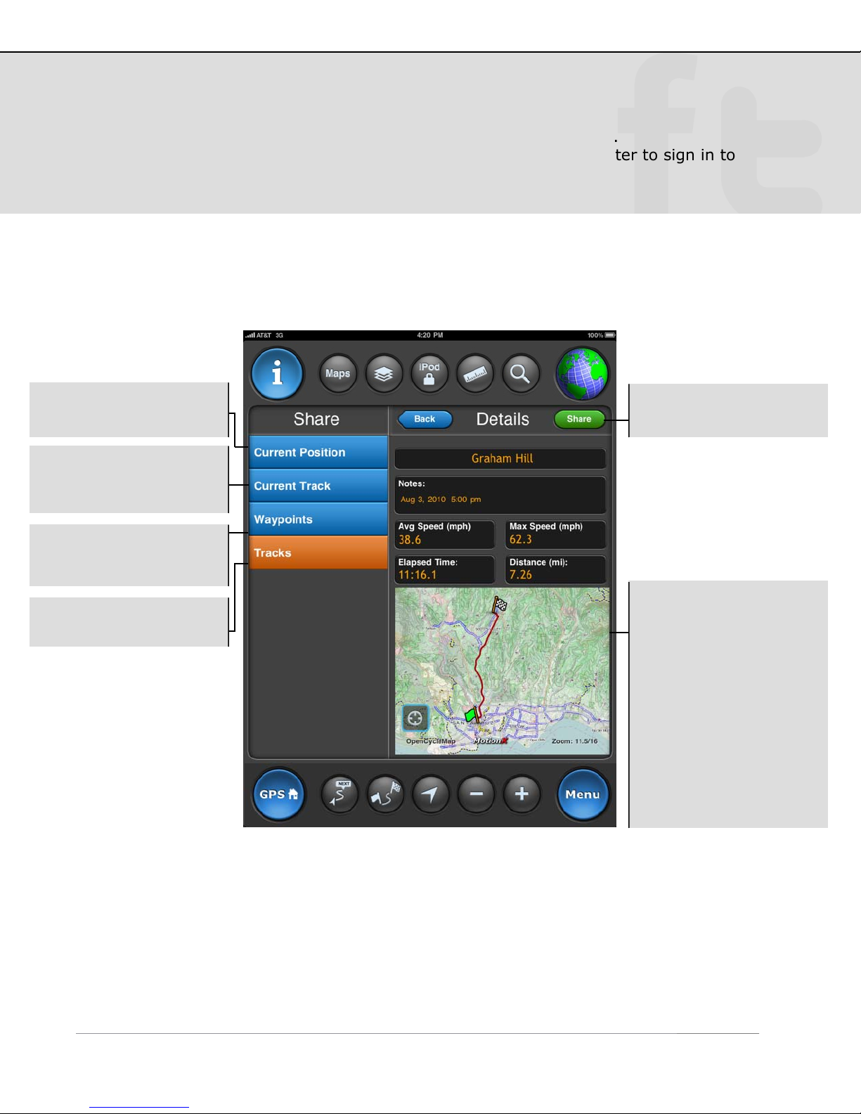
Share your current position, current track, waypoint or a saved track.
Share via email, facebook, or twitter. Go to Settings > Facebook/Twitter to sign in to
your Facebook and Twitter accounts.
Current Position: Share
your current location.
Current Track: Share
the track currently being
recorded.
Waypoints: Select from
your list of stored
waypoints.
Tracks: Select from your
list of stored tracks.
Share: Proceed to the
share preferences page.
Preview Pane:
•
Displays your selected
track or waypoint
overlaid on a map.
•
Change the map type
from the Maps page.
•
Pinch to zoom, swipe to
pan the view.
•
The region shown is
captured as a JPEG
image file and shared
along with the track or
waypoint details.
Page 22
9. Share (continued)
US and Foreign Patents Granted and Pending. Fullpower®, TapTap®, and ShakeShake® are registered trademarks of Fullpower Technologies, Inc.
MotionX™, Touch-N-Set™, Tilt ‘n Roll™, and TiltTilt™ are trademarks of Fullpower Technologies, Inc.All other trademarks remain the property of
their respective owners. © Copyright 2003-2010 Fullpower Technologies, Inc. All rights reserved.
22
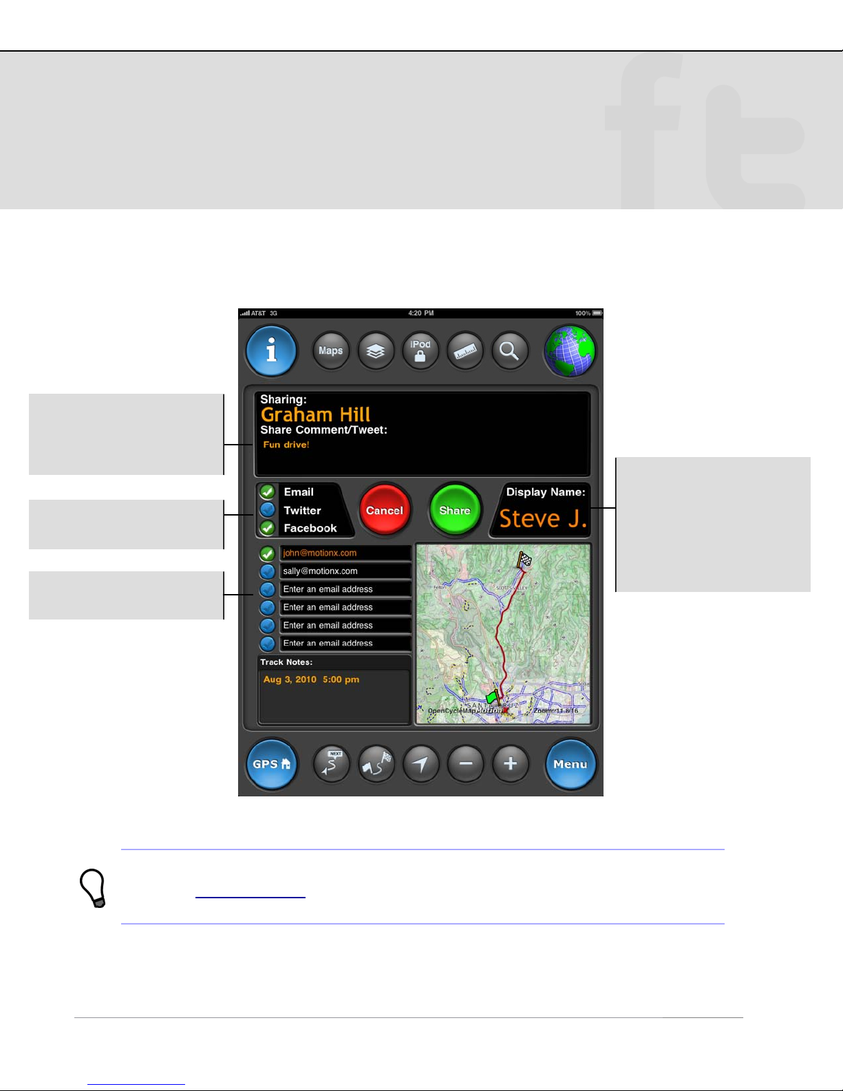
Share Preferences
Post a comment to go
along with your waypoint
or track (up to 120
characters).
Share to email1, twitter,
and/or facebook.
Share with up to six
email addresses at once.
Display Name:
This name will be posted
with your shared
waypoint or track
information to let your
friends know who you
are.
GPX file (GPS eXchange
waypoint on a map.
!
1
Attached to the email share will be three files: a KMZ file (for Google Earth), a
format), and a JPEG image file showing your track or
Page 23
10. Map Downloads
US and Foreign Patents Granted and Pending. Fullpower®, TapTap®, and ShakeShake® are registered trademarks of Fullpower Technologies, Inc.
MotionX™, Touch-N-Set™, Tilt ‘n Roll™, and TiltTilt™ are trademarks of Fullpower Technologies, Inc.All other trademarks remain the property of
their respective owners. © Copyright 2003-2010 Fullpower Technologies, Inc. All rights reserved.
23
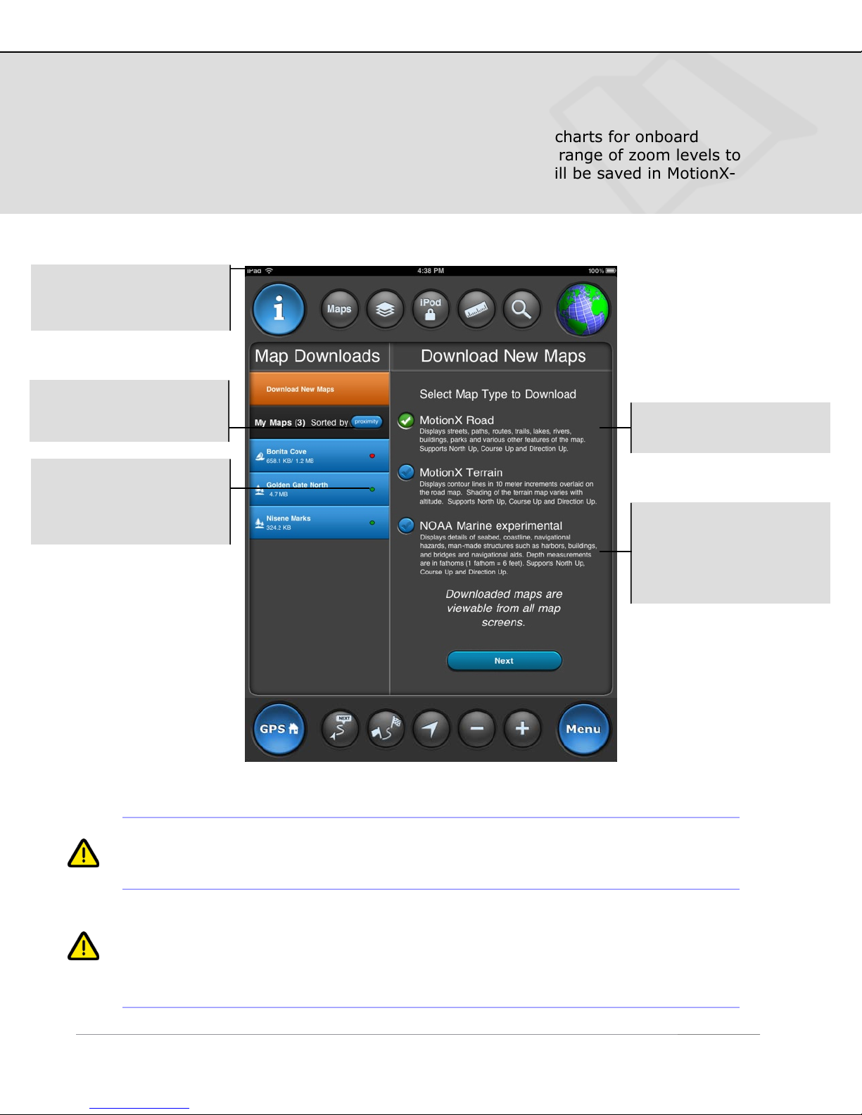
Download MotionX Road and Terrain maps and NOAA marine charts for onboard
storage on your iPad. Define an area of the map along with a range of zoom levels to
download for offline access. Once downloaded, these maps will be saved in MotionX-
GPS HD permanently unless you choose to delete them.
Maps are typically
downloaded faster via
Wifi.
List of your downloaded
map tile sets. Sort by
size, name, or proximity.
Download status:
• Green: fully downloaded
•
Red: partial download
1
Select a map type for
download.
Description of the map
type selected, including a
high-level summary of
features and map display
support.
1
1
these maps types cannot be cached or stored onboard. By contrast, MotionX road and
terrain maps and NOAA marine maps may be cached and stored onboard.
Map caching: Map caching and map downloading are two similar but distinct
features. Both improve map performance and enable offline map viewing. Map caching
automatically saves tiles viewed on the Maps page as you scroll and zoom. The cache
limit is 1024 MB; beyond this limit the oldest cached tiles are overwritten as new tiles
are cached. Cached and stored map tiles are not included in iTunes backups; cached
maps may be cleared at any time via Settings > Maps.
Due to Microsoft restrictions on Bing maps and Google restrictions on Google maps,
Page 24
10. Map Downloads (continued)
US and Foreign Patents Granted and Pending. Fullpower®, TapTap®, and ShakeShake® are registered trademarks of Fullpower Technologies, Inc.
MotionX™, Touch-N-Set™, Tilt ‘n Roll™, and TiltTilt™ are trademarks of Fullpower Technologies, Inc.All other trademarks remain the property of
their respective owners. © Copyright 2003-2010 Fullpower Technologies, Inc. All rights reserved.
24
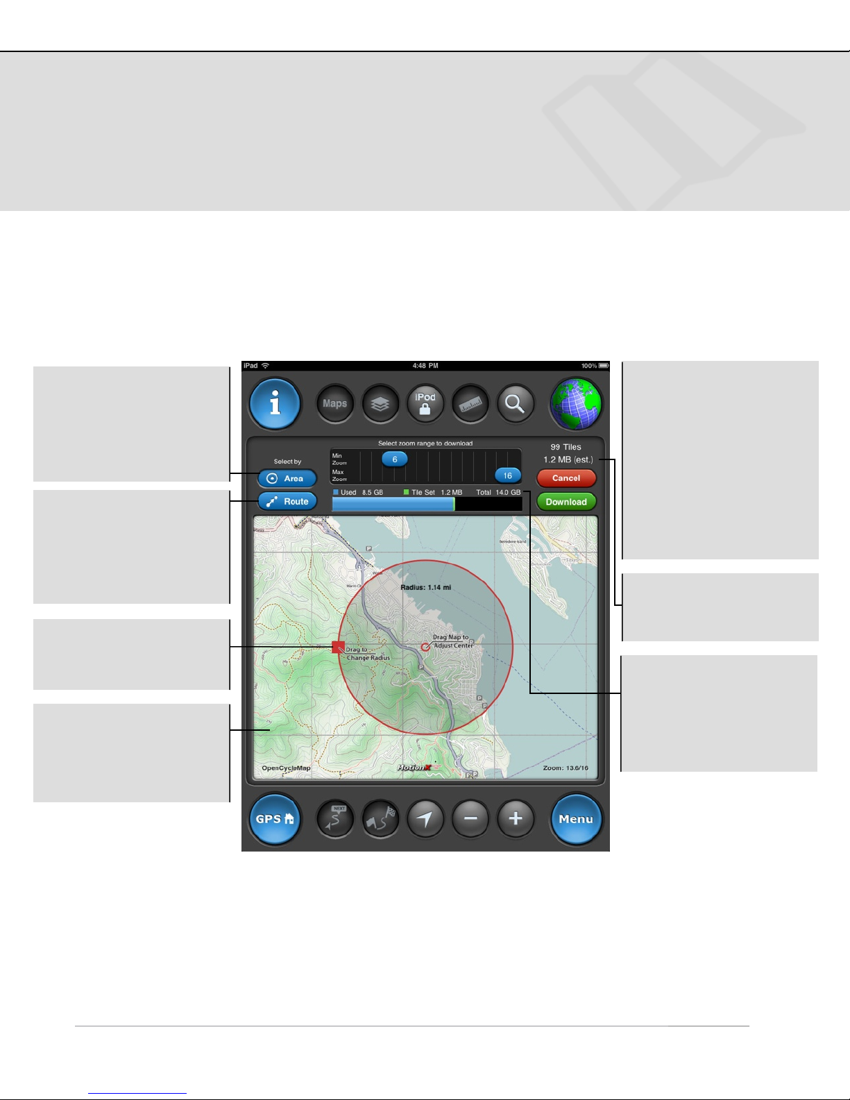
Area & Zoom Level Definition
Select by Area: define a
circular area of map tiles
to be downloaded. This is
useful for large areas
such as national parks or
entire cities.
Select by Route: Use
this option to define a
longer, narrower area.
Useful for pre-loading
map tiles along a hiking
trail, for example.
Touch and drag the red
square to adjust the
circumference.
Drag the map from
anywhere to adjust the
center of the download
area. Pinch-zoom to
adjust the zoom level.
Min/Max Zoom: Adjust
the min/max zoom levels
for which you'd like map
tiles downloaded. Higher
numbers represent a
more zoomed in view.
Thus the number of tiles
and total memory
required will be larger at
greater zoom level
numbers.
Total Size: Estimated
size of the tile set you've
selected.
Memory display:
• Amount of used disk
space on your iPad.
• Estimated tile set size.
• Total disk size of your
iPad.
!
Page 25
10. Map Downloads (continued)
US and Foreign Patents Granted and Pending. Fullpower®, TapTap®, and ShakeShake® are registered trademarks of Fullpower Technologies, Inc.
MotionX™, Touch-N-Set™, Tilt ‘n Roll™, and TiltTilt™ are trademarks of Fullpower Technologies, Inc.All other trademarks remain the property of
their respective owners. © Copyright 2003-2010 Fullpower Technologies, Inc. All rights reserved.
25
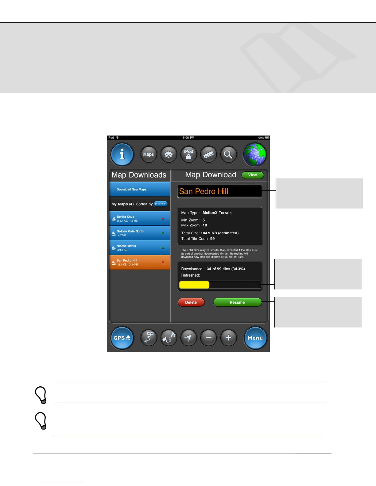
Download Summary
Tile Set Name: Choose
a name for the tile set
(touch the field to edit).
Progress bar: Monitor
the number and percent
of tiles downloaded.
Resume: Pause or
resume the download at
any time.
1
Downloads may be suspended and restarted later if needed.
Terrain map tiles tend to be larger than Road map tiles due to the contour data.
Tiles in urban areas also require more memory due to the density of street and
feature data.
!
Page 26
10. Map Downloads (continued)
US and Foreign Patents Granted and Pending. Fullpower®, TapTap®, and ShakeShake® are registered trademarks of Fullpower Technologies, Inc.
MotionX™, Touch-N-Set™, Tilt ‘n Roll™, and TiltTilt™ are trademarks of Fullpower Technologies, Inc.All other trademarks remain the property of
their respective owners. © Copyright 2003-2010 Fullpower Technologies, Inc. All rights reserved.
26
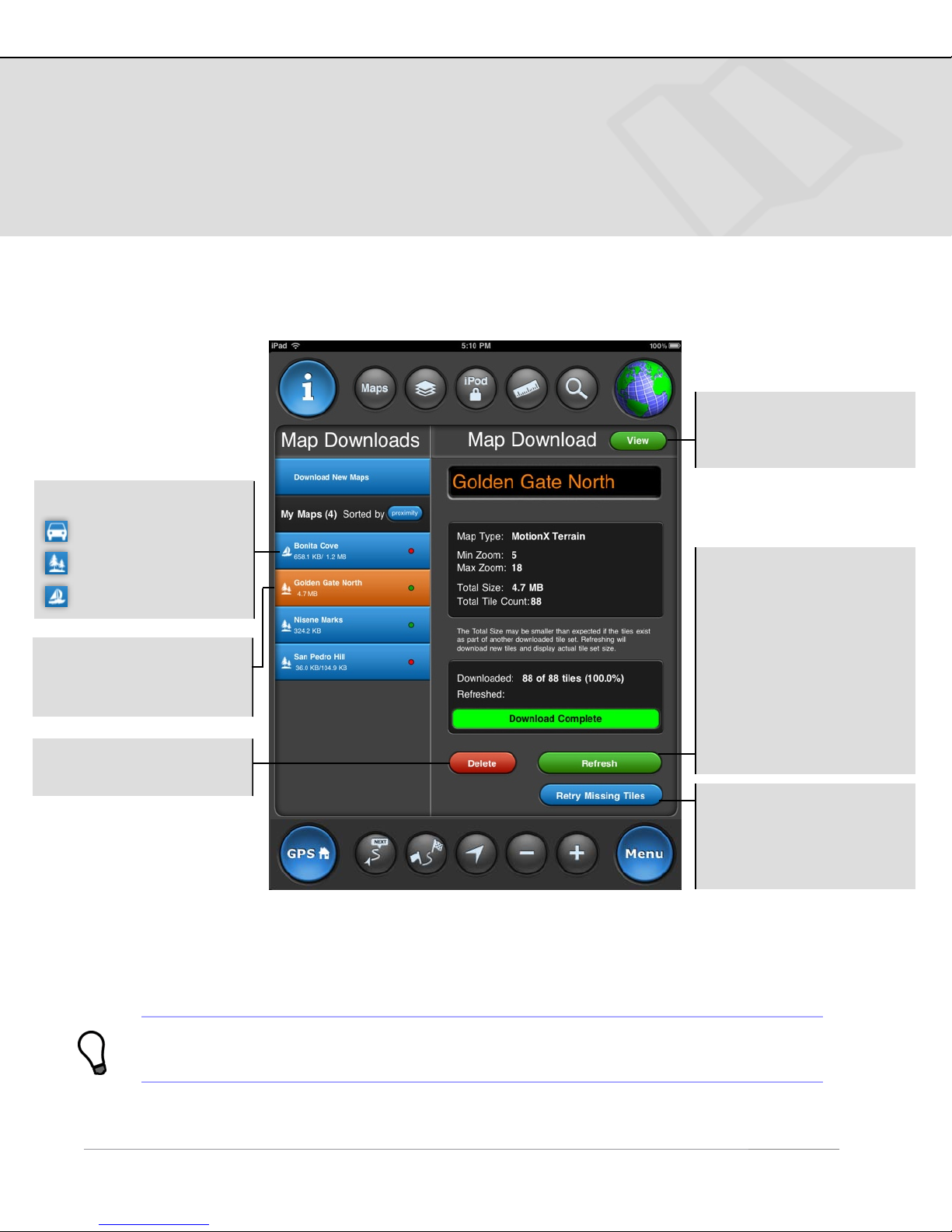
Marine map
Map Tile Sets
Icon indicates tile set type:
Road map
View: View all
downloaded map tiles in
the selected tile set.
1
Terrain map
Select a downloaded map
set to see details in the
right-hand panel.
Delete: Delete the map
tile set.
Refresh: Download the
latest map tiles for the
selected map tile set.
MotionX road and terrain
maps and NOAA marine
charts are updated
frequently; refreshing
every few weeks or
months is recommended
to ensure you have the
latest map data.
Retry Missing Tiles:
Attempt to download
missing maps tiles that
were unavailable for
download.
1
These tiles will always be viewable on all map pages, with our without a
network connection.
!
Page 27
11. Waypoints
US and Foreign Patents Granted and Pending. Fullpower®, TapTap®, and ShakeShake® are registered trademarks of Fullpower Technologies, Inc.
MotionX™, Touch-N-Set™, Tilt ‘n Roll™, and TiltTilt™ are trademarks of Fullpower Technologies, Inc.All other trademarks remain the property of
their respective owners. © Copyright 2003-2010 Fullpower Technologies, Inc. All rights reserved.
27
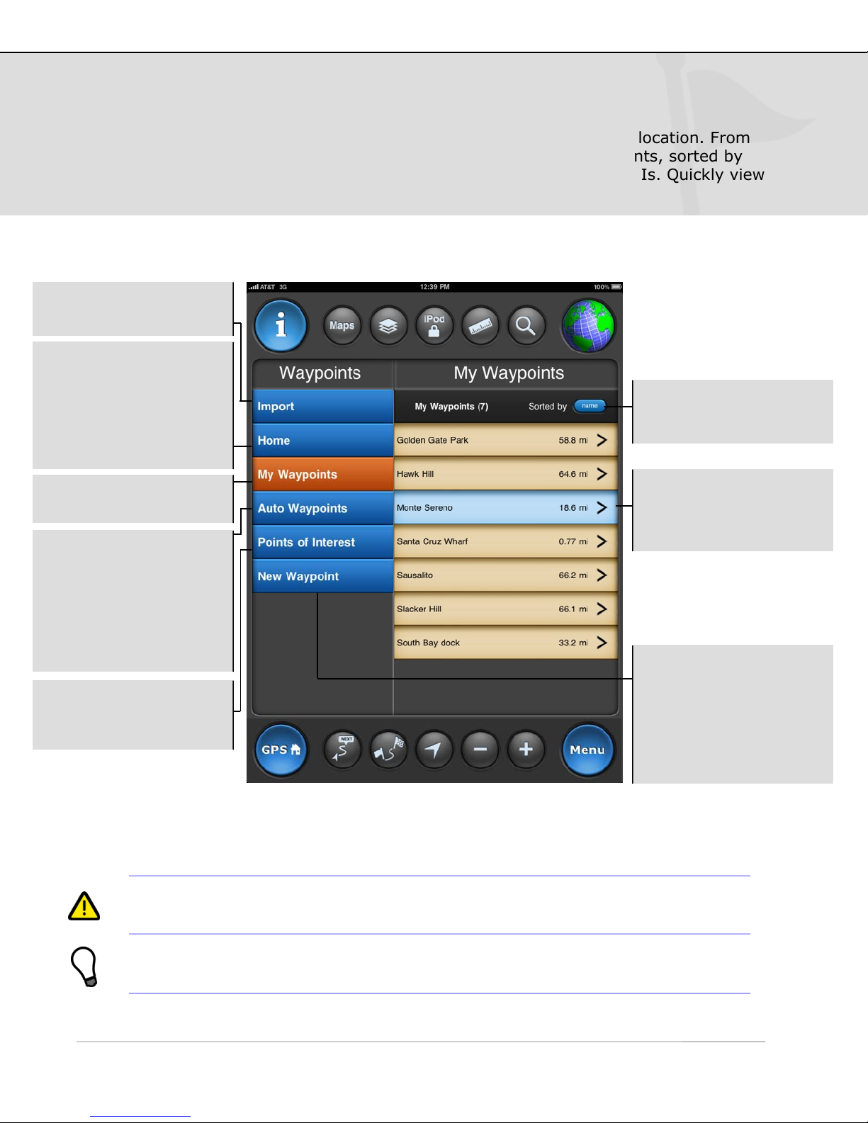
A waypoint is a set of coordinates that uniquely identifies a geographic location. From
this page you can create new waypoints and access your saved waypoints, sorted by
name, date, or proximity, and view the Auto waypoints and included POIs. Quickly view
your saved waypoints in a live map preview pane.
Import: Tracks and
waypoints with GPX file.
Home: Used as your
“current location” when
offline. When navigating
in Manual mode, the
range and bearing start
from the “Home” location
defined here.
Sort: Sort waypoints by
name, date, or proximity
to your current location.
My Waypoints: List of
your saved waypoints.
Auto Waypoints
created automatically by
MotionX-GPS HD:
•
Init (app launch)
• Start Nav
• Destination
• Last Valid Fix
POIs: Pre-loaded points
of interest to help you
start exploring.
1
2
1
Auto waypoints can be edited and saved as one of "My Waypoints", but
auto waypoints cannot be manually deleted.
Select a waypoint to see
details, notes, etc., and
to access additional
options.
New Waypoint: Create
a new waypoint using
one of the following:
• Current location
• TapTap® tool on map
• Enter Lat/Lon
• Enter range/bearing
2
Use the ‘Init’ automatic waypoint to find your way back to your starting point
(where you launched the application) in case you get lost.
Page 28
11. Waypoints (continued)
US and Foreign Patents Granted and Pending. Fullpower®, TapTap®, and ShakeShake® are registered trademarks of Fullpower Technologies, Inc.
MotionX™, Touch-N-Set™, Tilt ‘n Roll™, and TiltTilt™ are trademarks of Fullpower Technologies, Inc.All other trademarks remain the property of
their respective owners. © Copyright 2003-2010 Fullpower Technologies, Inc. All rights reserved.
28
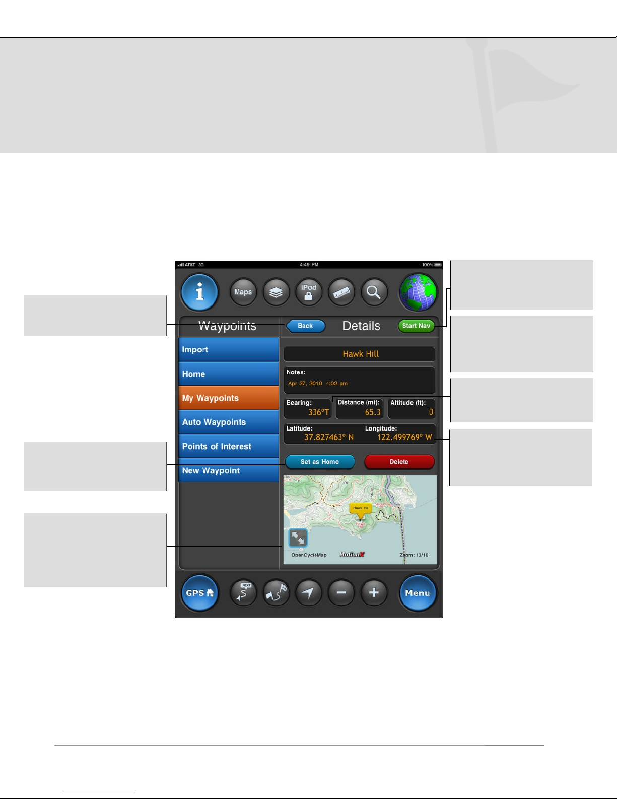
Waypoint Details
Back: Return to the list
of waypoints.
Start Nav: Initiate
navigation to this
waypoint.
Notes: Default text is
creation time & date of
the waypoint. This field is
editable.
Set as Home: Label this
waypoint as “Home”. For
use in Manual Mode.
View a preview of your
waypoint on the map.
The map type matches
your selected preference
on the Map page.
Bearing and Distance to
waypoint from your
current position.
Lat/Lon: Waypoint
location. UTM and MGRS
coordinate systems are
also available.
!
Page 29
12. Settings
US and Foreign Patents Granted and Pending. Fullpower®, TapTap®, and ShakeShake® are registered trademarks of Fullpower Technologies, Inc.
MotionX™, Touch-N-Set™, Tilt ‘n Roll™, and TiltTilt™ are trademarks of Fullpower Technologies, Inc.All other trademarks remain the property of
their respective owners. © Copyright 2003-2010 Fullpower Technologies, Inc. All rights reserved.
29
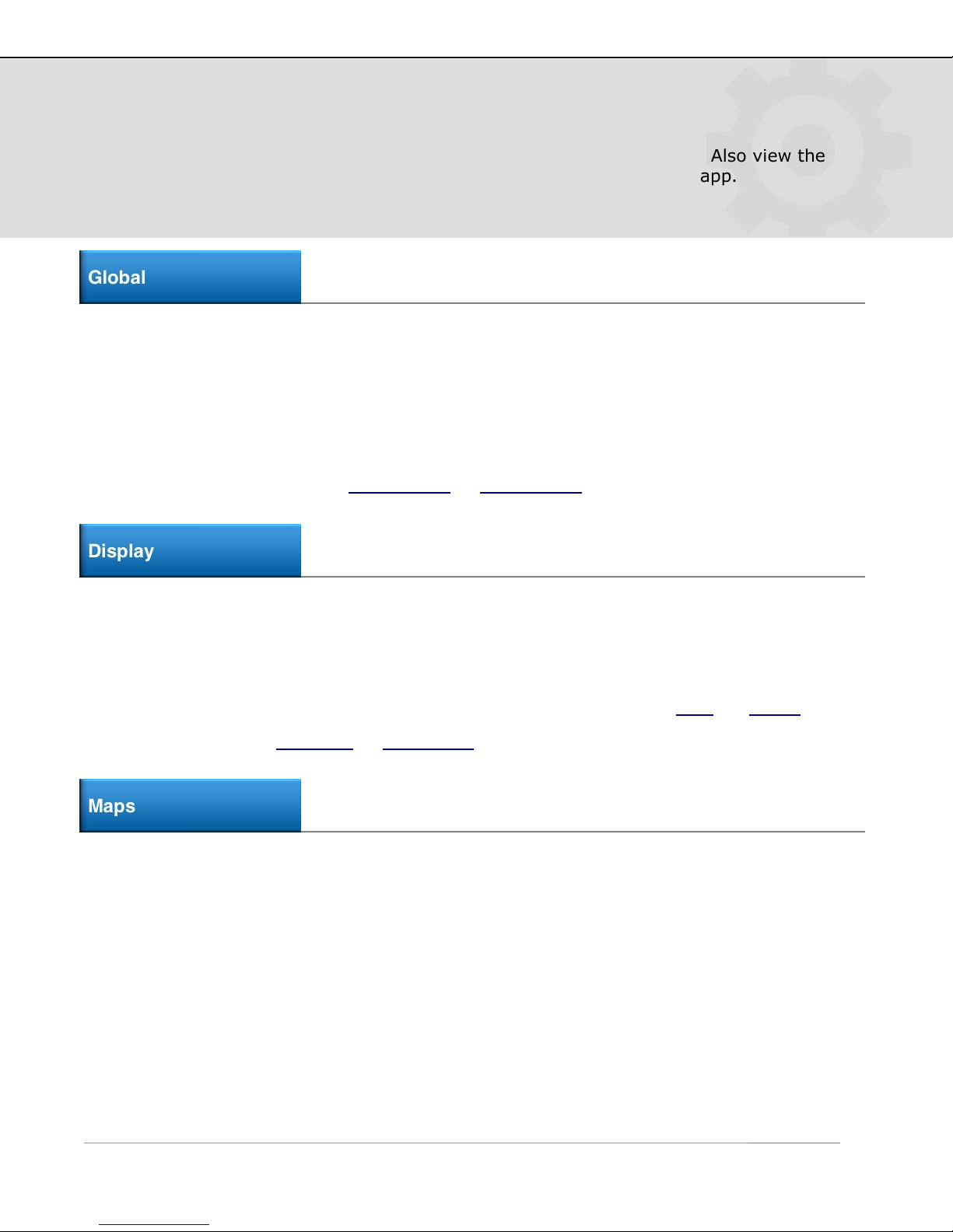
Adjust MotionX-GPS HD application preferences from the Settings page. Also view the
user manual and tutorials in a convenient webview without leaving the app.
Global
Sounds: Turn global application sound effects on or off.
Accelerometrics Assisted GPS: Toggle Accelerometrics ON for greater low-speed
accuracy, or OFF for improved battery life).
Accuracy Filter: The Accuracy Filter is ON by default for the best GPS position
accuracy. You may wish to switch the Accuracy Filter OFF if you are having trouble
acquiring a signal or when traveling at very high speeds (over 150 mph or 240 km/h).
Navigation: Choose between Rhumb Line
or Great Circle navigation.
Display
Speed Format: Choose between speed (mph, km/hr, kts) or pace (min/mi, min/km,
or min/nm).
Units: Select either metric, nautical or imperial units.
Coordinate Format: Select a coordinate display format: Degrees/Minutes/Seconds
(DMS), Degrees with decimal Minutes (DM), Decimal Degrees (DD), UTM
Compass: Use either Magnetic or True North as a reference.
Map Data: When toggled off, new map data will not be downloaded (for those
concerned about data usage).
Map Caching: Turn Map Caching ON to automatically cache MotionX Road, MotionX
Terrain, or NOAA map tiles so they can be viewed offline.
, or MGRS.
Map Cache Usage: View the used map cache (1024 MB available) and clear cache to
reset to zero.
Real Time Map Track: Clear your track from the Map.
Page 30

12. Settings (continued)
US and Foreign Patents Granted and Pending. Fullpower®, TapTap®, and ShakeShake® are registered trademarks of Fullpower Technologies, Inc.
MotionX™, Touch-N-Set™, Tilt ‘n Roll™, and TiltTilt™ are trademarks of Fullpower Technologies, Inc.All other trademarks remain the property of
their respective owners. © Copyright 2003-2010 Fullpower Technologies, Inc. All rights reserved.
30
GPS: Use GPS location data to determine your position and create tracks on the Map
screen (3G iPad only). When in GPS mode, the signal indicator in the upper left of
every screen will display a blue globe if you have a GPS signal and “GPS Searching” if
you don’t. Accuracy ranges from 30-300 feet.
Wifi: Select Wifi location mode if you are using a Wifi-only iPad, or if you are indoors
or without a direct view of the sky. This will provide an approximate position with an
accuracy between 100 feet to three miles using nearby Wifi access points.
Manual: When manual mode is selected, MotionX-GPS HD is not searching for
satellites or Wifi access points. When navigating in manual mode, the range and
bearing are defined from the the “Home” location you’ve defined in your saved
waypoints.
Track Recorder
Speed Format: Choose between speed (mph, km/h, kts) or pace (min/mi, min/km,
min/nm).
Units: Select imperial, metric, or nautical.
Auto Pause: Pause the track recorder automatically when you come to a stop.
Activity Modes: Select the appropriate activity mode for optimal accuracy.
Accelerometrics, accuracy filtering and other parameters will be selected for optimal
results based on your activity.
Voice Coaching
Use the voice coaching options to enable and customize audio updates while recording
a track.
• Turn voice coaching audio updates On/Off.
• Adjust the Update Interval slider to increase or decrease the time between voice
coaching updates.
• Control the sound level of voice coaching with the Voice Volume slider.
• Coaching updates may include time, distance, and/or speed/pace.
!
Page 31
12. Settings (continued)
US and Foreign Patents Granted and Pending. Fullpower®, TapTap®, and ShakeShake® are registered trademarks of Fullpower Technologies, Inc.
MotionX™, Touch-N-Set™, Tilt ‘n Roll™, and TiltTilt™ are trademarks of Fullpower Technologies, Inc.All other trademarks remain the property of
their respective owners. © Copyright 2003-2010 Fullpower Technologies, Inc. All rights reserved.
31
• Turn on Pause iPod for Voice to pause/resume your music during voice coaching
updates. When the switch is Off, music volume will fade during updates.
Configure GPS button
The GPS home button at the bottom left of each page enables quick access to one or
more pages of your choice. Choose to include any combination of the Track Recorder,
My Position, Map or Compass pages in the rotation. Tap the GPS home button to switch
between the selected pages.
Autocycle: Turn ON to autocycle the selected pages at a delay and interval of your
choice. Initiate autocycle following an idle time ranging from 10 sec to 5 min. View
each page in the rotation from 5 sec up to 1 minute.
Facebook/Twitt
Sign into or out of your Facebook (including Facebook Places) and Twitter accounts.
Online Tutorial
Configure how you would like MotionX-GPS to behave when you are running it in the
background while multitasking with other applications. Choose between Always On,
Optimized, or Always Off.
Online Tutorial
View the in-app MotionX-GPS HD tutorials to learn more about using the application.
!
Page 32
12. Settings (continued)
US and Foreign Patents Granted and Pending. Fullpower®, TapTap®, and ShakeShake® are registered trademarks of Fullpower Technologies, Inc.
MotionX™, Touch-N-Set™, Tilt ‘n Roll™, and TiltTilt™ are trademarks of Fullpower Technologies, Inc.All other trademarks remain the property of
their respective owners. © Copyright 2003-2010 Fullpower Technologies, Inc. All rights reserved.
32
User Manual
View a PDF version of the MotionX-GPS HD user manual. The manual is also available
for download at gpsHD.motionx.com
Reset
Restore to factory settings: Restore MotionX-GPS to its freshly installed
state. All data, content, and settings will be erased.
Reset map tile sets only: Deletes all downloaded map tile sets.
.
!
 Loading...