

Page 1

GPS
Personal
Tracker
User Manual
V1.1
MT80
Page 2

- 2 -
Contents
1.Product Overview
................................................................................................................ - 3 -
2.MT80 Characteristics
........................................................................................................... - 3 -
3.For Your Safety
................................................................................................................... - 4 -
4.Getting Started
.................................................................................................................. - 5 -
4.1 Tracker and Accessories
............................................................................................... - 5 -
4.2 View
......................................................................................................................... - 5 -
4.3 Functional Parts
.......................................................................................................... - 6 -
5.First Use
............................................................................................................................ - 6 -
6.Change Password
................................................................................................................ - 7 -
7.Time Zone
......................................................................................................................... - 7 -
8.Track
................................................................................................................................ - 8 -
8.1 Track by SMS
............................................................................................................. - 8 -
8.2Track by Calling
........................................................................................................... - 9 -
8.3Track by Preset Interval
............................................................................................... - 10 -
8.4 Google Earth and Google Map
...................................................................................... - 10 -
8.5 Track by MS01
.......................................................................................................... - 11 -
8.6Track by GPRS between Server and Tracker
.................................................................... - 11 -
8.7Track by GpsGate
....................................................................................................... - 12 -
9.Authorization
.................................................................................................................... - 12 -
10.Movement and Geo-fence
.................................................................................................. - 13 -
10.1 Movement Alarm
..................................................................................................... - 13 -
10.2 Geo-fence Alarm
...................................................................................................... - 13 -
11.Listen (Voice Wiretapping)
................................................................................................. - 14 -
12.Power Down
.................................................................................................................... - 15 -
13.Track Log
........................................................................................................................ - 15 -
13.1 Track by Interval
...................................................................................................... - 15 -
13.2 Auto Log when no GPRS
............................................................................................ - 16 -
14.Initialization
.................................................................................................................... - 16 -
15.Parameter Editor
.............................................................................................................. - 17 -
17.Troubleshooting
............................................................................................................... - 17 -
Contacts
............................................................................................................................. - 18 -
Page 3
- 3 -
1.Product Overview
Thanks for purchasing GPS Tracker MT80.
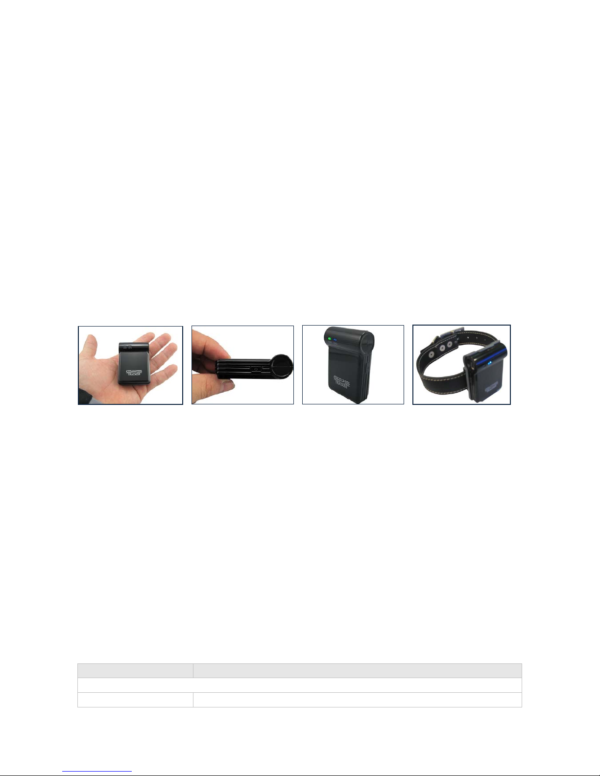
The MT80 is a very small, light-weight, quality tracking device specially designed for lone workers, children,
personal safety, car security or even pets.
Through GPS and GSM or GPRS communications, MT80 can get its position and send the position data back
to your mobile phone or server to be displayed on maps.
What’s New
- Compact Size - only 61mm x 42mm x 15mm
- Light Weight - only 50g (with battery)
- Low Power Consumption - 4 days in standby mode
- Fast and Stable Reception for GPS/GSM Signal
- Modern and Professional Design
- Quad-band GSM - Workable anywhere all over the world.
- Clip for watch belt or pet collar
Features
- SMS and GPRS TCP/UDP Communication
- Track on Demand
- Show Location Directly on Mobile Phone
- Track by Time Interval
- Listen (Voice Wiretapping)
- GSM Blind Area Memory
- Logging Capacity up to 180,000 Waypoints
- SOS Panic Button
- Movement Alarm
- Geo-fencing Control
- Low Battery Alarm
- GPS Blind Area Alarm (in/out).
2.MT80 Characteristics
Items Specification
Device
Charging Voltage DC 4.2-5.5V/400mA (Mini USB port)
Page 4

- 4 -
Battery Rechargeable and removable 700 mAh battery (3.7V)
Dimension 61x42x15mm
Weight 50g (with battery)
Operating temperature -20° to 55° C
Humidity 5% to 95% Non-condensing
Work time 96 hours in standby mode and 10 hours in c o ntinuous working mode
LED 2 LEDs showing GPS, GSM status
Button One SOS panic button and one power On/Off button
Microphone Built-in microphone for wiretapping
Memory 4MB
GSM
GSM module Quad-band GSM 850/900/1800/1900MHz
SIM Card Interface Support SIM card: 1.8V, 3V
GPS
GPS Chipset Latest SiRF Star III hig h sensitivity single-chip GPS receiver
GPS Sensitivity -159dB
GPS Frequency L1, 1575.42 MHz
C/A Code 1.023 MHz chip rate
Channels 20 channel all-in-view tracking
Position Accuracy 10 meters, 2D RMS
Velocity Accuracy 0.1 m/s
Time Accuracy 1 us synchronized to GPS time
Default datum WGS-84
Reacquisition 0.1 sec., average
Hot start <2 sec., average
Warm start 38 sec., average
Cold start 42 sec., average
Altitude Limit 18,000 meters (60,000 feet) max.
Velocity Limit 515 meters/second (1000 knots) max.
Acceleration Limit Less than 4g
Jerk Limit 20 m/sec
Certification
Module Approvals CE, GCF, FCC, RoHS, PTCRB, IC
3.For Your Safety
Read these simple guidelines. Not following them may be dangerous or illegal.
Switch on safely Do not switch on MT80 when wireless phone use is prohibited or whe n it may
cause interference or danger.
Switch off in hospitals Follow any restrictions. Switch MT80 off near medical equipment.
Switch off in aircraft Follow any restrictions. Wireless devices can cause interference in aircraft.
Switch off when refueling Do not use MT80 when at a refueling point. Do not use near fuels or
chemicals.
Page 5

- 5 -
Switch off near blasting Follow any restrictions. Do not use MT80 when blasting is in progress.
Qualified service Only qualified personnel can repair MT80.
Water resistance
MT80
is not fully water resistant. Keep it dry. Use waterproof bag if
necessary.
4.Getting Started
This section will describe how to set up your MT80.
4.1 Tracker and Accessories
MT80 is supplied in a box which includes:
MT80 Main Unit Two Batteries Wall Charger Car Charger Desktop Charger
USB Cable USB-to-Serial Adaptor Clip CD
4.2 View
Front view Back view Side view
Page 6
- 6 -
4.3 Functional Parts
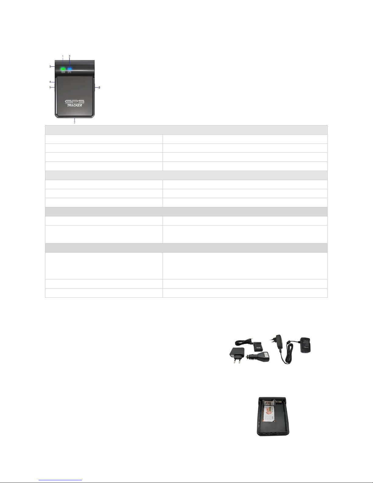
1. GSM LED (Green)
2. GPS LED (Blue)
3. Mini USB
4. Microphone
5. SOS Button
6. Power On/Off Button
7. Lanyard Loop
GPS LED - Blue
Normally ON SOS button is being pressed and held
Flashing ( every 0.1 second) The unit is being initialized
Flashing (0.1 second on and 2.9 seconds off) MT80 has a GPS fix
Flashing (1 second on an d 2 seconds off) MT80 has no GPS fix
GSM LED - Green
Flashing ( every 0.1 second) The unit is being initialized
Flashing (0.1 second on and 2.9 seconds off) MT80 is connected to the GSM network
Flashing (1 second on an d 2 seconds off) MT80 is not connected to the GSM network
Buttons
Power On/Off Button To turn on/off MT80
SOS Button When it is pressed, MT80 will send its position data back to the
authorized phone number or server
Other Connectors
Mini USB
Used for charging, firmware update, configuration
on PC and
exporting stored data. (USB-to-Serial Adaptor
is required for
firmware update, configuration and exporting stored data)
Microphone
for voice wiretapping (listen only)
Lanyard Loop
for connecting lanyard
5.First Use
- For the unit’s first use, it will take around 4 hours to fully
charge the battery.
Two ways to charge the battery:
- Put the battery into the tracker and charge it by wall or car
charger
- Put the battery on the desktop charger
- When charged, insert a workable SIM card and turn the unit on
pressing the On/Off button for 4 seconds.
-
It is important to keep the unit still and under the open sky for
it to successfully get a fix on the satellites.
Page 7
- 7 -
6.Change Password
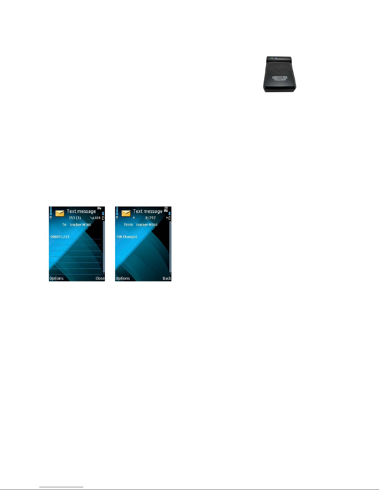
Command: ****PXXXX
Description: Send this SMS command to change user’s password
Note:
The tracker will only accept SMS commands from a user with the correct password. Commands with wrong
password will be ignored.
**** is the user’s password. The default password is 0000.
XXXX is new password. Passwords are in 4 digits
Example:
Command Response
The password is now changed to 1234.
7.Time Zone
Command: ****ZX
Description: Use this command to correct the time into your local time
Note:
X=0, to turn off this function
X=[1, 65535] to set time difference in minute to GMT.
For those ahead of GMT, just input the time difference in minute directly. For example, 0000Z120.
‘-‘is required for those behind GMT. For example, 0000Z-240.
This correction is only applied to location reports by SMS and SMS alarms, NOT GPRS.
Example:
-
Once the tracker has a GPS fix it will start to flash blue (0.1
second on and 2.9 seconds off).
-
Check that if Green LED is also flashing (0.1 second on and 2.9
seconds off) which means it has GSM connection
Page 8

- 8 -
or
Command Response
8.Track
8.1 Track by SMS
- Track on Demand - Reply with longitude, latitude, speed and date
Command: ****T
Description: Get the current location of your MT80, send this SMS to MT80 and it will report its
longitude and latitude by SMS.
Example:
Command Response
- Track on Demand - Reply with a Google Map link
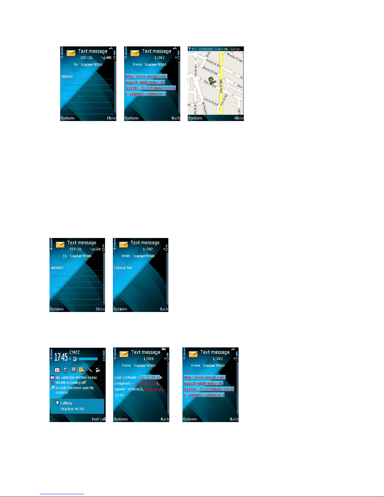
Command: ****H
Description: Send this command to MT80 then you receive an SMS with an http link. Click on the link
then the location can be shown directly on Google Map.
Note:
Only smart phones and PDA support this function.
Example:
Page 9
- 9 -
Command Response View
8.2Track by Calling
Command: ****RX
Description: Enable the tracker to report its longitude and latitude or Google Map link by SMS after a
missed call is made to the tracker.
Note:
X=0, turn off this function
X=1, SMS in normal format
X=2, SMS in Google Map format
Example:
Command Response
Then call the tracker and it will reply as follows:
or
Call Response
Page 10
- 10 -
8.3Track by Preset Interval
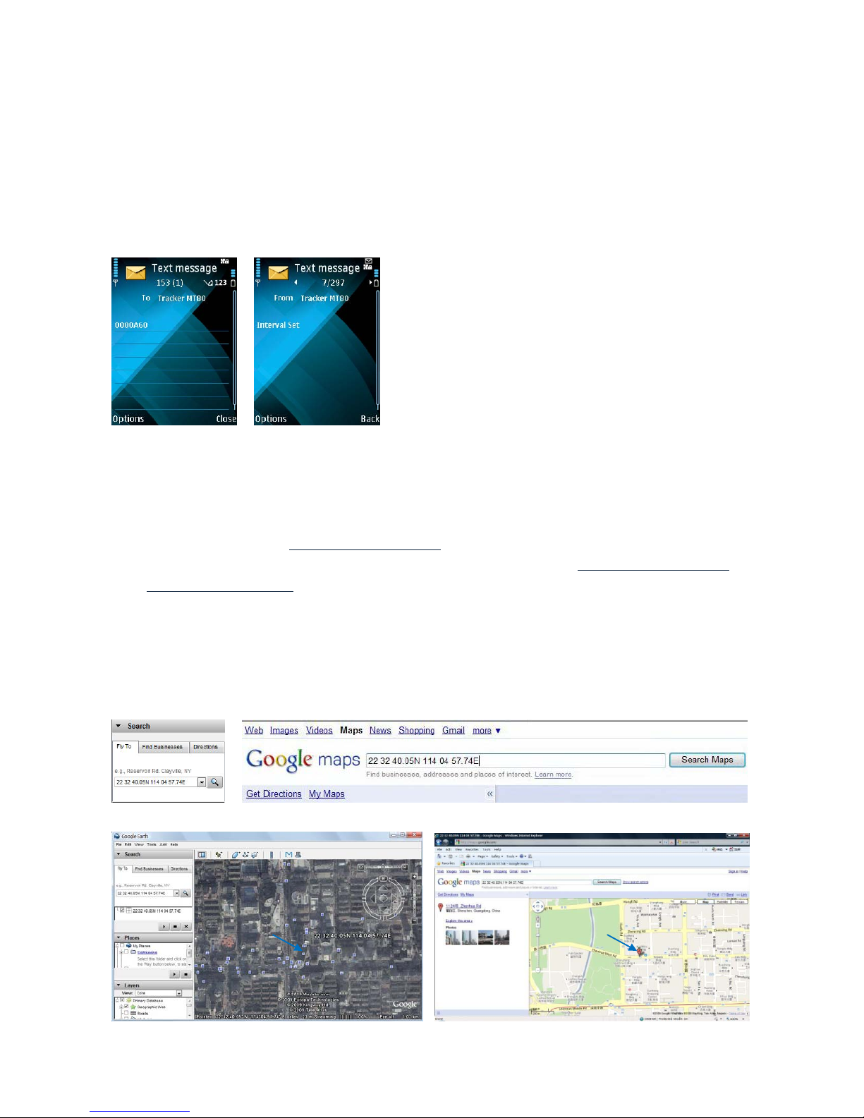
Command: ****AX
Description: Sets an interval for the tracker to continuously return its location by SMS
Note:
X is the interval in minute with range [0, 999].
If X=0 it will stop tracking by interval)
Example:
Command Response
The tracker will report its location by SMS every 60 minutes.
8.4 Google Earth and Google Map
Download Google Earth from
http://earth.google.com/.
Start Google Earth (For more information about Google Earth please refer to
http://earth.google.com/) or
go to
http://maps.google.com in your Internet Explorer
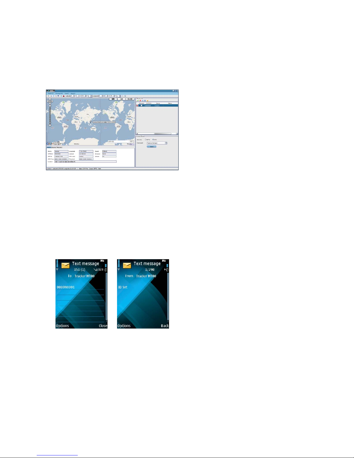
Input the latitude and longitude that you receive from the tracker by SMS and click the search button.
Google Earth or Google Maps will display the location for you.
Example:
When you receive: Latitude = 22 32 40.05N Longitude = 114 04 57.74E
Type as the following picture shows:
(Note: you should input the latitude and longitude as: 22 32 40.05N 114 04 57.74E)
And then you can find the location of your tracker:
Page 11
- 11 -
Or you can use local map software on PDA or car navigation device to input the coordinates.
8.5 Track by MS01
If you have bought our GPS Tracking Software MS01, after proper configuration, you can do tracking on
MS01.
GPS Tracking System - MS01
Please refer to MS01 User Guide for more information.
8.6Track by GPRS between Server and Tracker
- Set Tracker’s GPRS ID
Command: ****NX
Description: Send this command to set an GPRS ID for the tracker.
Note:
X is the GPRS ID in digit only and 14 digits max.
Example:
Command Response
Tracker’s ID is now 0001.
- Enable GPRS Tracking
Command: ****GIP,Port,APN,Username,Password,X,T
Description: This command is to set IP, Port, APN, etc. to enable GPRS tracking.
Note:
IP: xxx.xxx.xxx.xxx
Port: [1,65534]
APN defaulted as CMNET.
Page 12

- 12 -
If no username and password required, just leave them blank.
X=0, turn off GPRS tracking (default);
X=1, enable TCP
X=2, enable UDP
T is the interval of sending GPRS packet with range [0, 65535]. It is in the unit of 10 seconds.
Example:
0000G220.121.7.89,8500,CMNET,trackingmate,6688,1,60 [with APN user name and password]
0000G220.121.7.89,8500,CMNET, , ,1,60 [without APN user name and password]
Command Response
So the GPRS tracking interval is 600 seconds (10 minutes).
For more information regarding GPRS tracking please refer to <MT80 GPRS Communication
Protocol>
8.7Track by GpsGate
The MT80 supports GpsGate Software.
Please contact us or GpsGate for more information of settings.
9.Authorization
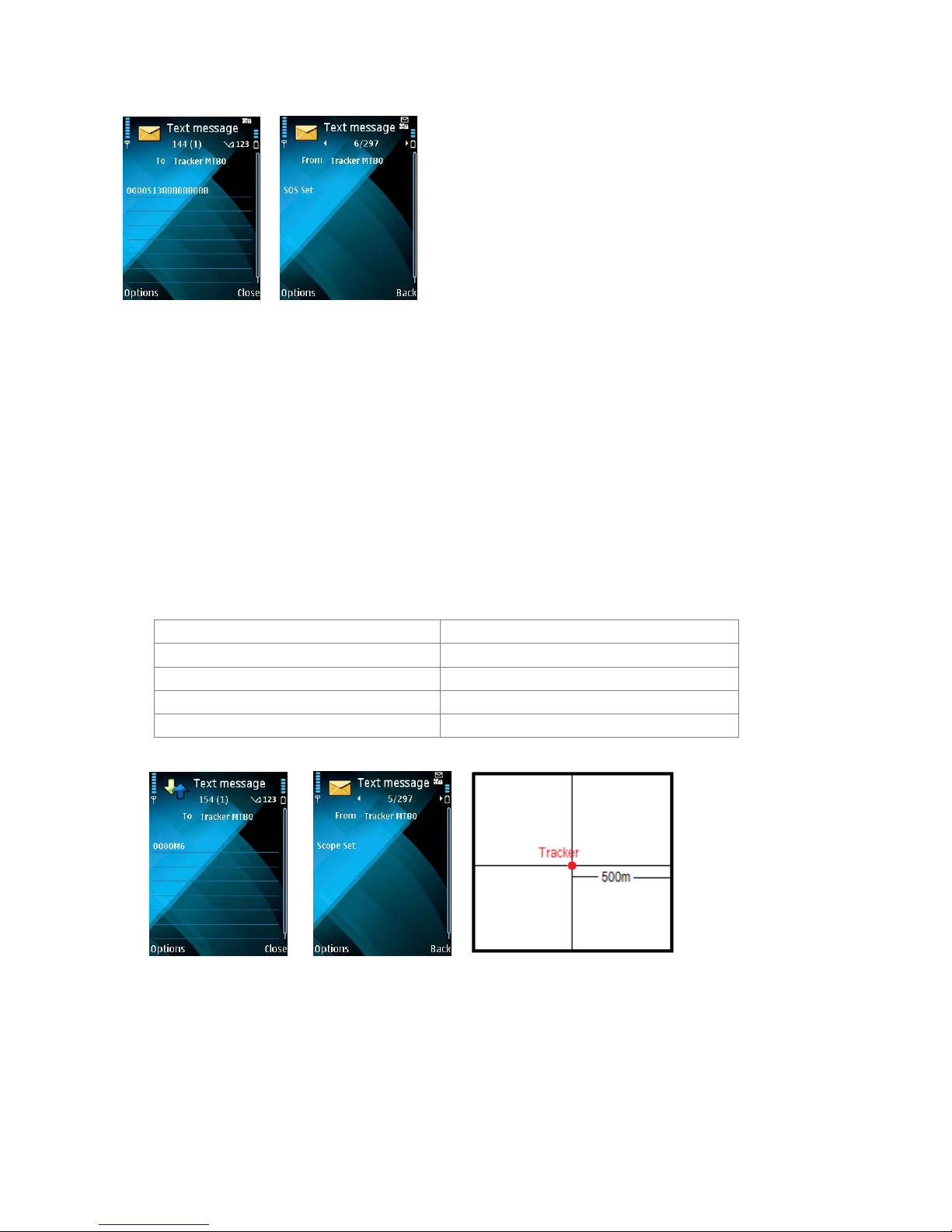
Command: ****SX
Description: This is to authorize a phone number for the SOS button for receiving position reports or SMS
alarms
Note:
X is the mobile phone number to receive messages.
Example:
Page 13
- 13 -
Command Response
When the SOS button is pressed, the tracker will send an SMS to telephone number ‘13888888888’. Other
alarm will be also sent to this phone number.
10.Movement and Geo-fence
10.1 Movement Alarm
Command: ****MX
Description: Send this command to set movement alarm. When MT80 moves out of a preset square
scope, it will send an SMS alarm to the authorized phone number for SOS button.
Note:
X is preset distance to original place
X=0, to turn off this function =5, 300m
=1, 30m =6, 500m
=2, 50m =7, 1000m
=3, 100m =8, 2000m
=4, 200m
Example:
Command Response
An SMS alarm will be sent if the tracker holder moves more than 500 meters to the original place.
10.2 Geo-fence Alarm
Command: ****EX or ****LX
Description: Turn on Geo-fencing alarm. When the tracker moves in/out the preset scope, it will send
Page 14

- 14 -
an SMS alarm to the authorized phone number for SOS.
Note:
1. ****EX is to set alarm when the tracker enters the preset square scope and,
2. ****LX is to set alarm when the tracker exits the preset square scope.
3. Only one alarm can be set in either of above commands.
4. X is the coordinates which include Lower-left X,Lower-left Y,Upper-right X,Upper-right Y. For
example: 11404.0000,E,2232.0010,N,11505.1234,E,2333.5678,N
5. Lower-left X should be less than Upper-right X;
6. All longitudes and latitudes should be in ASCII format as follows:
Longitude: DDDMM.MMMM,E/W. 4 places of decimal. ‘0’ is needed to be stuffed if no v alue available.
Latitude: DDMM.MMMM,N/S. 4 places of decimal. ‘0’ is needed to be stuffed if no value available;
7. Send ****M0 to turn off Geo-fence function.
8. Only one alarm can be set in either Movement Alarm or Geo-fence Al ar m ;
Example:
Command Response
MT80 will send out SMS once it moves out the scope of 11404.0000,E,2232.0010,N,11505. 1234,E,
2333.5678,N
11.Listen (Voice Wiretapping)
Command: ****WX
Description: Authorize a phone number to make a silence call to the tracker, the track answers the call
automatically and allows the caller to listen to what happens around the tracker. There is no voice indication
that the call is in progress.
Note:
X is the telephone number for wiretapping.
Example:
Page 15

- 15 -
Command Response
When you use 13888888888 to call MT80, it will answer the phone automatically and then you can hear what
is happening around the tracker holder.
12.Power Down
Command: ****FX
Description: Make the tracker into power down mode when it is inactive for a period of time. In Power Down
states, GPS stops working and GSM enters sleep and stop sending out message until it is activated by
message, incoming calls or triggered by buttons.
Note:
X=0, to turn off this function.
X=1~255, to turn on Power Down after a specified period of being inactive. It is in unit of minute.
Example:
Command Response
The tracker will enter power down mode after it is inactive for 10 minutes.
13.Track Log
13.1 Track by Interval
Command: ****KX
Description: Set time interval for logging GPS information. The information is stored within the device
memory . When the memory get s full, the newest record will be overwritten on top of the oldest (FIFO - First
In, First Out). In that case, only the newest information is stored.
Note:
Page 16

- 16 -
1. X=0, to turn off this function. X=[1, 65535] to set interval in the unit of SECOND.
2. The logged message is in GPRMC format and includes:
Date and time
Longitude
Latitude
Speed
Direction
3. All data, stored within the memory , may be exported to the PC using the USB connector. For this matter
the “GPSLog” program has to be used (please refer to < GPSLog User Guide> and <GPRS Communication
Protocol> for more information).
4. The device has 4MB internal memory space for storing the track log and is able to store up to 180,000
records within the memory.
Example:
:
Command Response
The tracker will store GPS data every 10 seconds.
13.2 Auto Log when no GPRS
When there is no GPRS connection, the tracker can store all GPS information triggered by preset tracking
interval, alarms, request, or button activation and send this information (FIFO - First In, First Out) to server
by GPRS or preauthorized mobile phone by SMS when GPRS connection recovers.
The interval memory can store up to 1500 SMS and 4600 GPRS message.
14.Initialization
Command: default
Description: This is to make all settings back to factory default.
Note:
When MT80 is on, send ‘default’ to the tracker to make all settings back to factory default
Example:
Page 17
- 17 -
Command Response
15.Parameter Editor
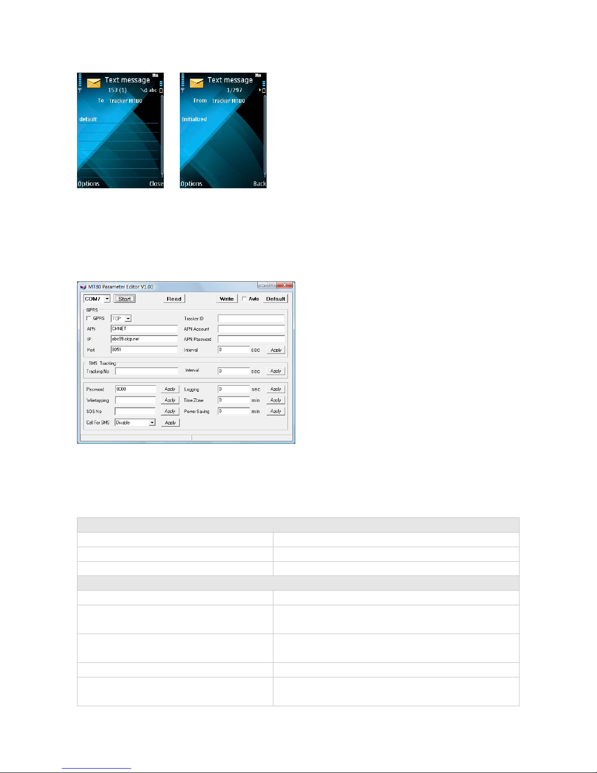
The tracker can be configured by computer using the Par ameter Editor instead of sending SMS commands.
MT80 Parameter Editor
Please refer to <MT80 Parameter Editor> for more information.
17.Troubleshooting
Problem: Tracker will not turn on
Possible Cause: Resolution:
The power button is not pressed long enough Press and hold the button for 3-5 seconds.
Battery needs charging Recharge battery for 4 hours
Problem: Tracker will not reply with SMS
Possible Cause: Resolution:
Green LED is flashing (on for 1 second and off
for 2 seconds)
Make MT80 connected to GSM network.
GSM Network is slow Some GSM networks slow down during peak time or when
they have equipment problems.
Unit is sleeping Cancel sleeping mode
Wrong password in your SMS or wrong SMS
format
Write correct password or SMS format
Page 18

- 18 -
The SIM card has run out of credit Replace or top up the SIM card
Problem: Green LED is Flashing (on for 1 second and off for 2 seconds)
Possible Cause: Resolution:
No GSM signal Check with a mobile phone to see if there is a signal in the
area or try to call the unit to see if you hear a ring tone.
No SIM card Insert a working SIM card. Check in phone that the SIM
can send SMS message.
SIM card has expired Check in phone that the SIM can send SMS message.
Replace SIM card if needed.
SIM has PIN code set Remove PIN code by inserting SIM in you phone and
deleting the code.
SIM is warped or damaged Inspect SIM, clean the contacts. If re-inserting does not
help try another to see if it will work.
Roaming not enabled If you are in a different country your SIM account must
have roaming enabled.
Battery is low Recharge the unit and the GSM will start working.
Problem: Blue LED is Flashing (on fo r 1 s econd and off for 2 seconds) or the SMS received
starts with ‘Last…’
Possible Cause: Resolution:
Unit does not have clear view of the sky Move the unit to a location wh ere the sky is visible. Tall
buildings, trees, heavy rain, can cause problems with the
GPS reception.
Bad GPS reception Place the front side of MT80 towards sky
Battery is low Recharge the unit and the GPS will start working.
Problem: Unit Fails to Connect to Server via GPRS
Possible Cause: Resolution:
SIM card in MT80 does not support GPRS
function
Enable SIM card GPRS function.
GPRS function of MT80 is turned off Turn on GPRS function of MT80.
Incorrect IP address or PORT Get the right IP address and PORT and reset to MT80.
GSM signal is weak Move the unit to a location with good GSM reception.
Contacts
If you encounter any problems when using our products, and cannot solve them by you rself , please contact
our technical support team by writing an E-Mail. We will be pleased to help you.
 Loading...