

Page 1

User Manual
Mappy Iti S446 / S449 (TM C), M appy Ulti
S549 (TMC), Mappy Maxi S719 (TMC)
Navigation software for the Mappy PND
UK English
April 2013, ver. 1.0
Page 2

Thank you for choosing the Mappy PND as your navigator. Start using Mappy PND right
away. This document is the detailed description of the navigation software. You can easily
discover Mappy PND while you are us ing it; however, we still recomm end that you read this
manual to fully understand the screens and features.
2
Page 3

Table of contents
1 Warnings and Safety information ............................................................................. 6
2 Getting started ............................................................................................................. 7
2.1 Navigation menu ................................................................................................................. 8
2.2 Buttons and other controls on the screen ............................................................................ 9
2.2.1 Using keyboards ...................................................................................................................... 10
2.2.2 Beyond single screen tap ......................................................................................................... 11
2.3 Map screen ........................................................................................................................ 12
2.3.1 Na vigating on the map ............................................................................................................. 12
2.3.2 Position marker s ...................................................................................................................... 14
2.3.2.1 Vehimarker and Lock-on-Road ......................................................................................................... 14
2.3.2.2 Selected map location (Cursor) and selected map object ................................................................. 14
2.3.3 Objects on the map .................................................................................................................. 15
2.3.3.1 Streets and roads .............................................................................................................................. 15
2.3.3.2 Turn preview and Next street ............................................................................................................ 15
2.3.3.3 Lane information and Signposts........................................................................................................ 16
2.3.3.4 Junction view .................................................................................................................................... 17
2.3.3.5 Motorway exit services ..................................................................................................................... 17
2.3.3.6 3D object types.................................................................................................................................. 18
2.3.3.7 Elements of the active route .............................................................................................................. 18
2.3.3.8 Traffic events..................................................................................................................................... 19
2.3.4 Manipulating the map .............................................................................................................. 20
2.3.5 Quick menu .............................................................................................................................. 21
2.3.6 Checking the details of the current position (Where Am I?) ................................................... 24
3 On-road navigation ................................................................................................... 26
3.1 Selecting the destination of a route ................................................................................... 26
3.1.1 Combined Search ..................................................................................................................... 26
3.1.1.1 Combined Search - Navigating to a recent destination (History) ..................................................... 29
3.1.1.2 Combined Search - Navigating to a Favourite destination ............................................................... 30
3.1.1.3 Combined Search - Navigating to an address ................................................................................... 31
3.1.1.4 Combined Search - Navigating to an intersection ............................................................................ 32
3.1.1.5 Combined Search - Navigating to a Place of Interest ....................................................................... 33
3.1.1.6 Combined Search - Navigating to a Place of Interest by its category ............................................... 34
3.1.2 Entering an address or a part of the address ............................................................................. 35
3.1.2.1 Entering an address .......................................................................................................................... 35
3.1.2.2 Entering the midpoint of a street as the destination .......................................................................... 37
3.1.2.3 Selecting an intersection as the destination ...................................................................................... 39
3.1.2.4 Selecting a city/town centre as the destination.................................................................................. 40
3.1.2.5 Entering an address with a postal code ............................................................................................ 42
3.1.2.6 Tips on entering addresses quickly ................................................................................................... 44
3.1.3 Selecting the destination from the Places of Interest ............................................................... 44
3.1.3.1 Quick search for a Place of Interest.................................................................................................. 44
3
Page 4

3.1.3.2 Searching for a Place of Interest using preset categories ................................................................. 46
3.1.3.3 Searching for a Place of Interest by category ................................................................................... 48
3.1.3.4 Searching for a Place of Interest by name ........................................................................................ 51
3.1.3.5 Selecting nearby assistance from 'Where Am I?'............................................................................... 53
3.1.4 Selecting a map location as the destination.............................................................................. 55
3.1.5 Selecting the destination from your Favourites ....................................................................... 56
3.1.6 Selecting one of the most likely de stinations (Smart History) ................................................. 57
3.1.7 Selecting a recent destination from the History ....................................................................... 58
3.1.8 Entering the coordinate of the destination ............................................................................... 59
3.1.9 Building a route from the list o f de stinations (Create Route) .................................................. 60
3.2 Viewing the entire route on the map ................................................................................. 61
3.3 Checking route parameters and accessing route related functions .................................. 61
3.4 Modifying the route ........................................................................................................... 62
3.4.1 Selecting a new destina tion when alrea dy having a ro ute: New Route, Waypoint or Final
Destination .......................................................................................................................................... 63
3.4.2 Setting a new starting position for the route ............................................................................ 63
3.4.3 Editing the list of destinations (Edit Route) ............................................................................. 65
3.4.4 Paus ing the active route ........................................................................................................... 66
3.4.5 Cancelling the active route....................................................................................................... 66
3.4.6 Checking route alternatives when plannin g the route .............................................................. 66
3.4.7 Checking route alternatives for an existing route .................................................................... 67
3.4.8 Changing the vehicle used in route planning ........................................................................... 69
3.4.9 Changing the road types used in route planning ...................................................................... 70
3.5 Saving a location as a Favourite destination .................................................................... 71
3.5.1 Editing the details of a Favourite d e stination ........................................................................... 71
3.6 Saving a map location as an alert point ........................................................................... 72
3.7 Editing an alert point ........................................................................................................ 73
3.8 Watching the simulation of the route ................................................................................ 74
4 Off-road navigation ................................................................................................... 76
4.1 Selecting the destination of the route ................................................................................ 76
4.2 Navigating in off-road mode ............................................................................................. 76
5 Reference Guide ........................................................................................................ 77
5.1 Concepts ............................................................................................................................ 77
5.1.1 Smart Zoom ............................................................................................................................. 77
5.1.2 Daytime and night colour themes ............................................................................................ 77
5.1.3 Tunnel view ............................................................................................................................. 77
5.1.4 Route calculation and recalculation ......................................................................................... 78
5.1.5 Green routing ........................................................................................................................... 80
5.1.6 Road safety cameras and other proxi mity alert points ............................................................. 81
5.1.7 Speed limit warning ................................................................................................................. 82
5.1.8 Battery and GPS position quality indicators ............................................................................ 82
4
Page 5

5.1.9 Traffic information in route planning ...................................................................................... 83
5.1.9.1 Historical traffic ............................................................................................................................... 84
5.1.9.2 Real-time traffic information (TMC) ................................................................................................. 84
5.2 'More' menu....................................................................................................................... 86
5.3 Settings menu .................................................................................................................... 87
5.3.1 Sound and Warnings ................................................................................................................ 88
5.3.2 Customise Quick menu ............................................................................................................ 90
5.3.3 Traffic setting s ......................................................................................................................... 90
5.3.4 Route settings ........................................................................................................................... 91
5.3.5 User profiles ............................................................................................................................. 95
5.3.6 Map settings ............................................................................................................................. 96
5.3.7 Vis ual guidance set tings .......................................................................................................... 97
5.3.8 Display settings ........................................................................................................................ 98
5.3.9 Regional settings ...................................................................................................................... 99
5.3.10 Trip monitor settings .............................................................................................................. 99
5.3.11 Log collection settings ......................................................................................................... 100
6 Glossary .................................................................................................................... 101
7 End User Licence Agreement ................................................................................. 103
8 Copyright note ......................................................................................................... 109
5
Page 6

1 Warnings and Safe t y information
The navigation system helps you find your way to your destination with the built-in GPS
receiver. Mappy PND does not transmit your GPS position; others cannot track you.
If you accept it when first using the app lication, Mappy PND collec ts usage inform ation and
GPS logs that may be used for improving the application and the quality and coverage of
maps. The data is processed anonymously; no one will be able to track any personal
information. If you change your mind later, you can enable or disable the log collection in
Settings (page 100).
It is important that you l ook at the displa y onl y when it is saf e to do s o. If you are t he driv er of
the vehicle, we recomm end that you opera te Mappy PND before you start your journe y. Plan
the route before your departure and stop if you need to change the route.
You must obey the traffic signs and follow the road geometry. If you deviate from the
recommended route, Mappy PND changes the instructions accordingly.
Never place Mapp y PND where it obstr ucts the driver's view, where it is in the deployment
zone of an airbag or where it might cause injuries in an accident.
For more information, consult the End User Licence Agreement (page 103).
6
Page 7
2 Getting st arted
Mappy PND is optim ised for in-car or pedestrian use. There is no need t o use a stylus. You
can use it easily by tapping the screen buttons and the map with your fingertips.
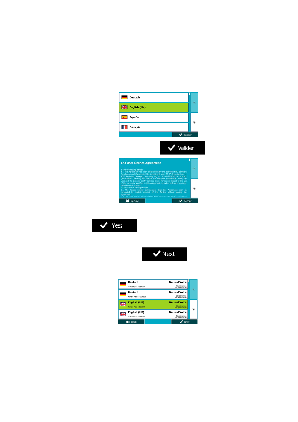
When using the navigation software for the first time, an initial setup process starts
automatically. Do as follows:
1. Select the written language of the application interface. Later you can change it in
Regional settings (page 99).
2. Read the End User Licence Agreement. Tap
3. You are now asked whether you allow the software to collect usage information and
GPS logs that may be used for improving the application and the quality and coverage
of maps. Tap
function. Later you can turn them on or off individually in Log collection settings (page
100).
4. The Configuration wizard starts. Tap
5. Select the language and speaker used for voice guidance messages. Later you can
change it in Sound and Warnings settings (page 99).
to allow the anonymous statistics or disable this
to continue.
to continue.
6. If needed, modify the time format and unit settings. Later you can change them in
Regional settings (page 99).
7
Page 8
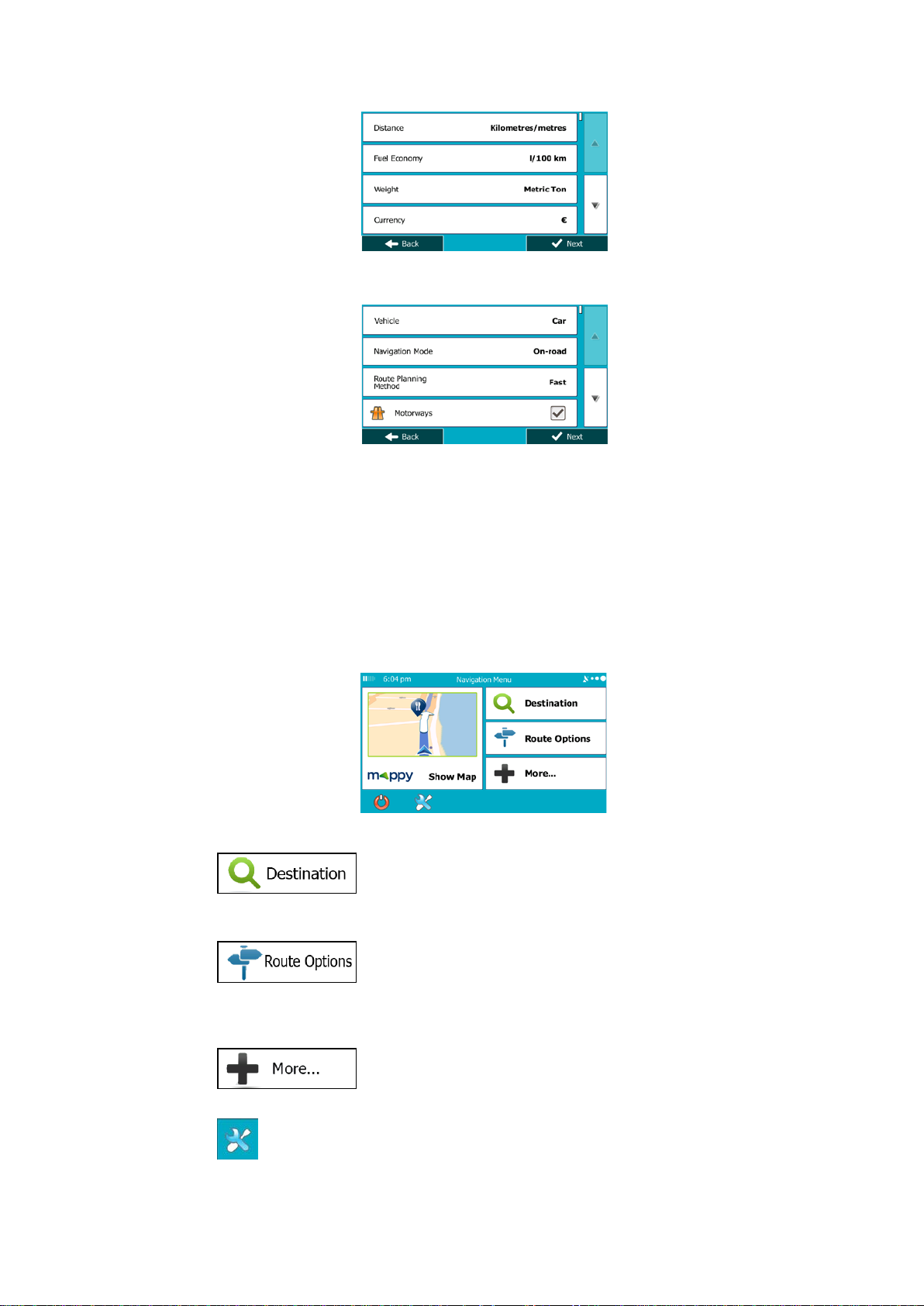
7. If needed, modify the default route planning options. Later you can change them in
Route settings (page 91).
8. The initial setup is now complete. The Configuration wizard can be restarted later from
the Settings menu (page 87).
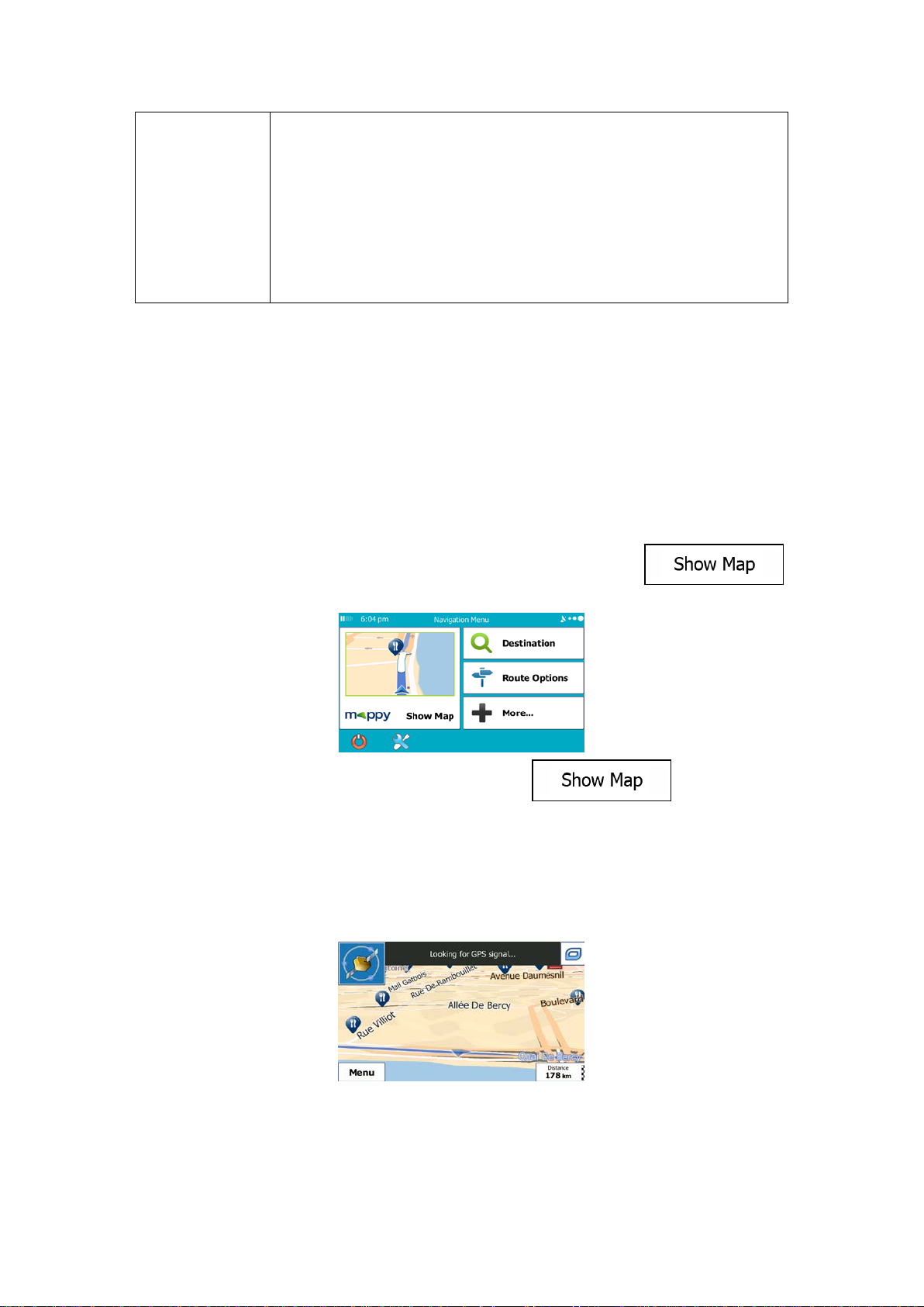
After the initial setup, the Navigation menu appears and you can start using Mappy PND.
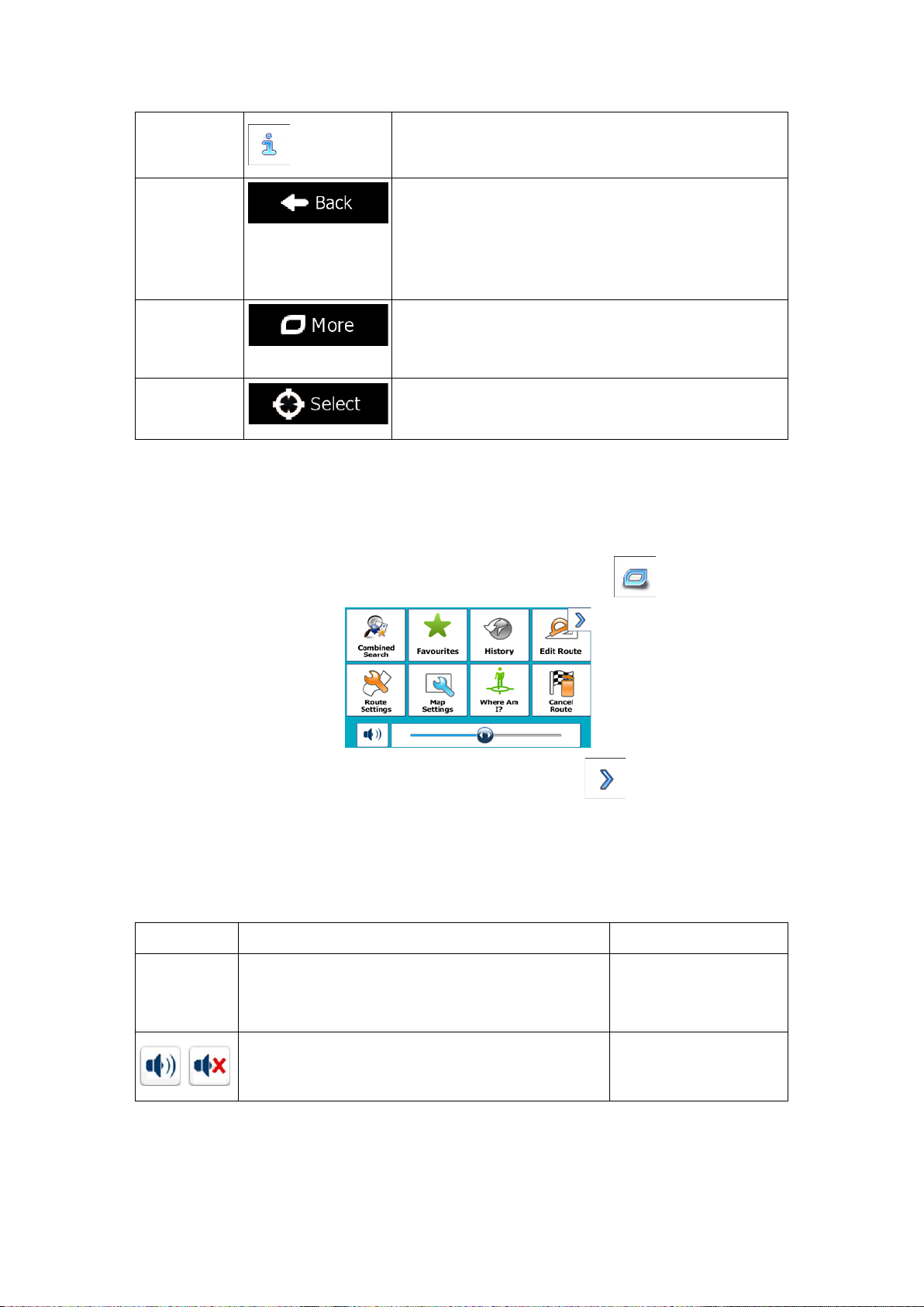
2.1 Navigation menu
You can reach all parts of Mappy PND from the Navigation menu.
You have the following options:
• Tap
a place of interest, a location on the map or one of your Favourite destinations. You
can also look up your recent destinations from the Smart History or enter a coordinate.
• Tap
on the map. You can also perform route-related actions such as editing or cancelling
your route, setting a start point for the route, picking route alternatives, avoiding parts
of the route, simulating navigation or adding the destination to your Favourites.
• Tap
applications.
• Tap
to customise the way the navigation software works.
to select your destination by entering an address or selecting
to display the route parameters and the route in its full length
to simulate demo routes or to run some additional
8
Page 9
• Tap to start navigating on the map. The button itself is a miniature
Type
Example
Description
How to use it
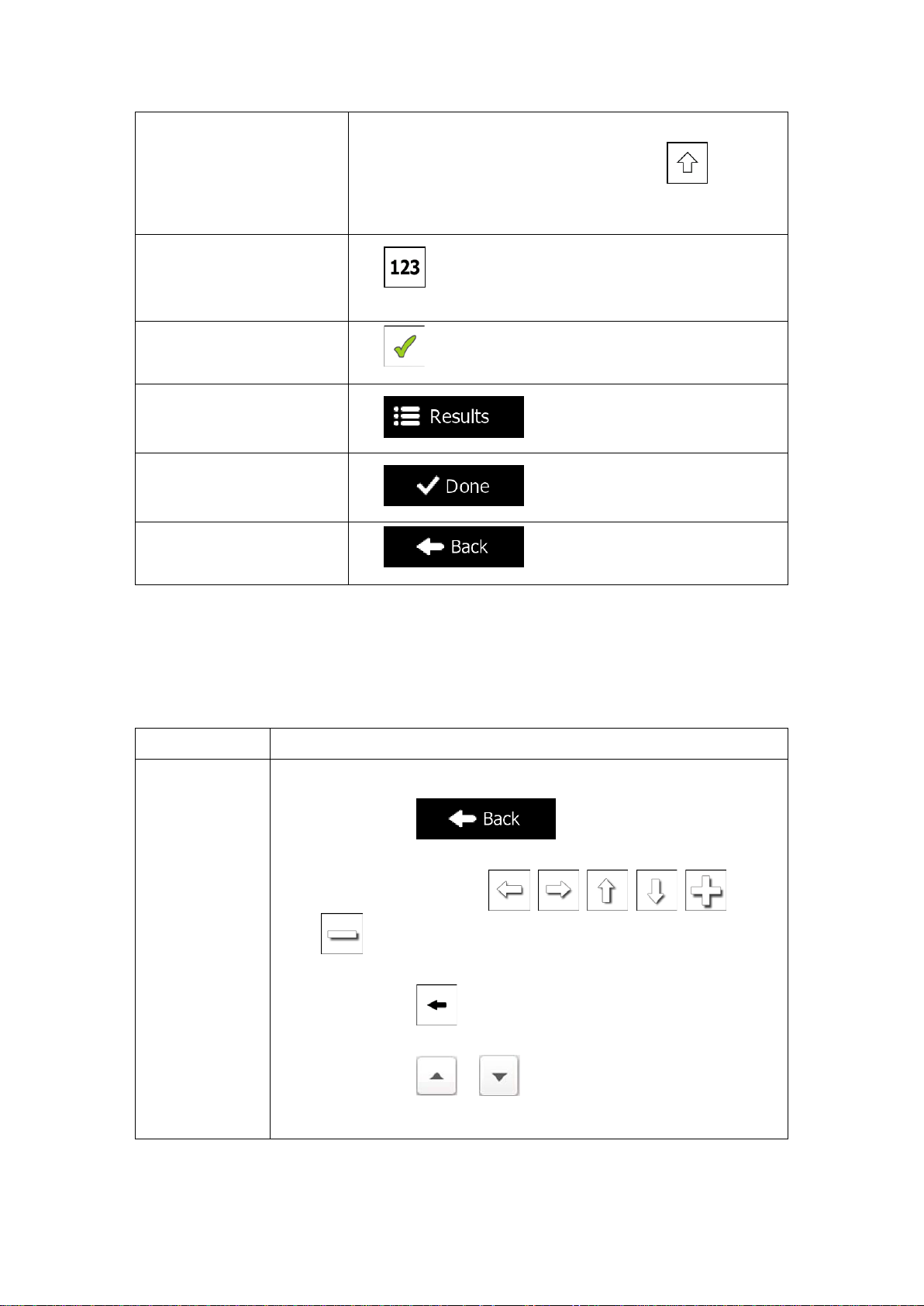
Button with
Icon
Some icons also
live map that shows your current position, the recommended route and the surrounding
map area. Tap the button to enlarge the map to the full screen.
• Tap
• Tap
to open the Traffic Summary screen.
to stop navigation and exit the software.
2.2 Buttons and other controls on the screen
When you are using Mappy PND, you usually tap buttons on the touch screen.
You only need to c onfirm selections or changes if the applicat ion needs t o restart , it needs to
perform a major reconfiguration, or you are about to lose some of your data or settings.
Otherwise, Mappy PND saves your selections and applies the new settings without
confirmation as soon as you use the controls.
Button
value
Tap it to initiate a function,
to open a new screen, or to
set a parameter.
Some buttons display the
current value of a field or
setting. Tap the button to
change the value. After the
change, the new value is
shown on the button.
Tap it once.
Tap it once.
List
Shows status information.
When you need to select
from several options, they
appear in a list.
9
function as a button.
Tap them once.
Grab the list anywhere
and slide your finger up
or down. Depending on
the speed of the sliding,
the list will scroll fast or
slow, only a bit or till the
end.
Alternatively, move
between pages with the
and
buttons and tap the
value that you want.
Page 10
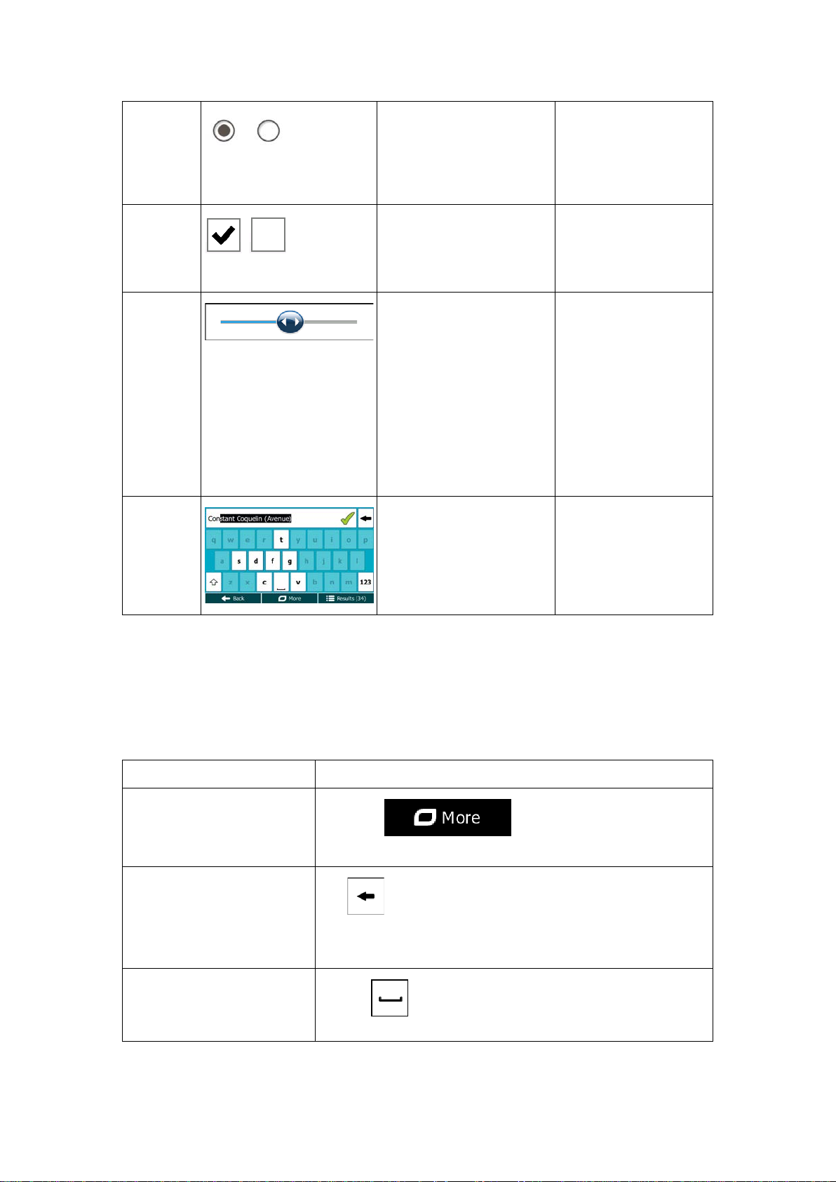
Radio
Each key is a touch
Task
Instruction
Switching to another
button and select the new
Correcting your entry on the
Tap and hold the button to delete several characters or the
Entering a space, for
multi-word street names
button
When there are only a few
choices, radio buttons may
be used instead of lists.
Only one value can be
selected.
Tap one of the buttons
to select a new value.
Switch
Slider
Virtual
keyboard
When there are only two
choices, a checkmark
shows whether the feature
is enabled.
When a feature can be set
to different values in a
range, Mappy PND shows
an indicator on a gauge
that displays and sets the
value.
Alphabetic and
alphanumeric keyboards to
enter text and numbers.
Tap it to turn the switch
on or off.
• Drag the handle
to move the
slider to its new
position.
• Tap the slider
where you want
the handle to
appear; the
thumb jumps
there.
screen button.
2.2.1 Using keyboards
You only need to enter let ters or numbers when you cannot avoid it. You ca n type with your
fingertips on the f ull-s c reen keyboards and you ca n switch between var ious keyboard layouts,
for example English, Greek or numerical.
keyboard layout, for example
from an English keyboard to
a Greek keyboard
keyboard
example between a first
name and a family name or in
Tap the
keyboard layout from the list.
Tap to remove the unneeded character(s).
entire input string.
Tap the button at the bottom centre of the screen.
10
Page 11
Entering upper and lower
case letters
Entering numbers and
Finalising the keyboard entry
search result)
Finalising the keyboard entry
Finalising the keyboard entry
Cancelling the keyboard
previous screen)
Action
Details
Tapping and
When entering a text, the first character appears in upper case
symbols
(accepting the suggested
(opening the list of search
results)
(saving your input)
entry (returning to the
while the rest of the text is in lower case. Tap
an upper case letter or tap twice to turn on Caps Lock. Tap
again and lower case letters return.
Tap to switch to a keyboard offering numeric and
symbol characters.
Tap .
Tap .
Tap .
Tap .
to enter
2.2.2 Beyond single screen tap
You usually need to tap the screen only once. However, some useful features can be
accessed with combined touch screen tapping. Those are the following:
holding the
screen
Tap and keep pressing the following buttons to reach extra functions:
• Tap and hold
Map screen appears.
• Tap and hold any of the
buttons on the Map screen: you can rotate, tilt or scale the
map continuously.
• Tap and hold
characters quickly.
• Tap and hold
continuously.
on keyboard screens: you can delete several
or in long lists: you can scroll pages
on list and menu screens: the
, , , , , and
11
Page 12
Gestures
(drag&drop)
You need to drag and drop the screen only in cases like:
• Moving the handle on a slider.
• Scrolling the list: grab the list anywhere and slide your finger up or
down. Depending on the speed of the sliding, the list will scroll fast
or slow, only a bit or till the end.
• Moving the map in map browsing mode: grab the map, and move it
in the desired direction.
2.3 Map screen
2.3.1 Navigating on the map
The Map screen is the most frequently used screen of Mappy PND.
A small live map is dis played on the Navigation m enu, as a part of the
button.
To enlarge this small map and open the Map screen, tap
This map shows the current position (the Vehimarker, a blue arrow by default), the
recommended route (an orange line), and the surrounding map area.
When there is no GPS position, the Vehimarker is transparent. It shows your last known
position.
You see coloured dots circling around a satellite symbol in the top left corner. The more green
dots you see, the closer you are to get the valid GPS position.
.
12
Page 13
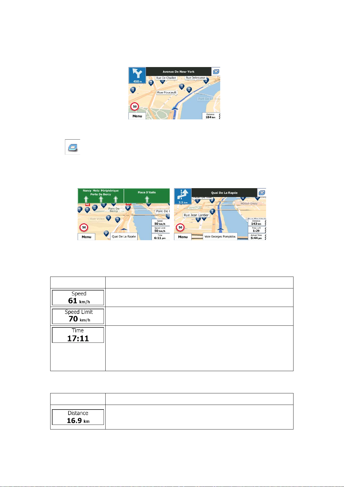
Field
Description
Shows your current speed given by the GPS receiver.
Shows the speed limit of the current road if the map contains it.
Shows the current time corrected with time zone offset. The accurate
time comes from the GPS satellites, and the time zone information
is always displayed in the top left corner of menu
Field
Description
Shows the distance you need to travel on the route before reaching your
When GPS position is avail able, the Vehimark er is displayed in full colour , now showing your
current position.
There are screen buttons and data fields on the screen to help you navigate. During
navigation, the screen shows route information.
The
available functions in Settings.
By default, only one data f ield is displayed in th e bottom right corner. T ap this field to see all
route data fields. T ap any of the d ata fields to s uppress others an d display onl y the selected
one.
The data fields are differ ent when you are navigating an ac tive route and when you have no
specified destination (the orange line is not displayed).
Default data fields when cruising without a destination (tap and hold any of the fields to
change its value):
button gives quick access to frequently used functions. You can change the
comes from the map or it can be set manually in Regional settings.
(The current time
screens.)
Default data fields when navigating a route (tap and hold any of the fields to change its value):
final destination.
13
Page 14
Shows the time needed to reach the f inal dest ination of the route bas ed
If Mappy PND is capable of receiving live traffic information, the
hey
the estimated arrival time at the final destination of the route
If Mappy PND is capable of receiving live traffic information, the
ing your route if they
on information available for the remaining segments of the route.
calculation takes into account traffic delays af fecting your route if t
are received. However, this calculation is rarely accurate.
Historical traffic data can also be taken into account if data is available.
Shows
based on information available for the remaining segments of the route.
calculation takes into account traffic delays af fect
are received. However, this calculation is rarely accurate.
Historical traffic data can also be taken into account if data is available.
2.3.2 Position markers
2.3.2.1 Vehimarker and Lock-on-Road
When your GPS position is available, Mappy PND marks your current position with the
Vehimarker. By default, this marker is a blue arrow, but you can change this icon in Settings.
The exact location of the Vehimark er depends on the vehicle type used f or route calculat ion
and the navigation mode. Both can be set in Route settings (page 91).
• If you choose pedestrian and/or off-road navigation: The Vehimarker is at your exact
GPS position. The direction of the icon shows your current heading.
• In all other cases: The Vehimarker may not show your exact GPS position and
heading. If roads are near, it is aligned to the nearest road to suppress GPS position
errors, and the direction of the icon is aligned to the direction of the road.
2.3.2.2 Selected map location (Cursor) and selected map object
You can mark a map location in the following ways:
• Tap the map when navigating,
• Tap the map when you are asked to confirm the destination at the end of a search, or
• Tap the map in Find on Map (page 55)
When a map location is selected, t he Cursor appears at the selected poi nt on the map. The
Cursor is displayed with a radiating red dot (
The location of the Cursor can be used as the dest ination of the route, a n ew alert point , you
can search for Places around it, or you can save this location as one of your Favourite
destinations.
You can also select som e of the objec ts on th e m ap. If you tap the m ap at the ic on of a Place
of Interest or an a lert point, the obj ect will be selecte d (you see a red c ircling border aro und
the object), and you can get information about this object or use it as a route point.
) to make it visible at all zoom levels.
14
Page 15
2.3.3 Objects on the map
Icon
Description
Turn left.
Turn right.
Turn back.
Bear right.
Turn sharp left.
Keep left.
2.3.3.1 Streets and roads
Mappy PND shows the streets in a way that is similar to how the paper road m aps show
them. Their width and colours c orrespond to th eir importance: you can easi ly tell a m otorway
from a small street.
2.3.3.2 Turn preview and Next street
When navigating a r oute, the t op sec tion of the Map s cr een sho ws infor m ation about the nex t
route event (manoeuvre) and the next street or the next city/town.
There is a field in the top left corner that displays the next manoeuvre. Both the type of the
event (turn, roundabout, exiting m otorway, etc.) and its distance from the current position are
displayed.
A smaller icon shows the type of the second next manoeuvre if it is near the first one.
Otherwise, only the next manoeuvre is displayed.
Most of these icons are very intuitive. The following t able lists some of the frequently sho wn
route events. The same symbols are used in both fields:
15
Page 16
Continue straight in the intersection.
Go left on the roundabout, 3rd exit (next
manoeuvre).
Enter roundabout (second next manoeuvre).
Enter motorway.
Exit motorway.
Board ferry.
Leave ferry.
Approaching a waypoint.
Approaching the destination.
2.3.3.3 Lane information and Signposts
When navigating on m ultilane roads, it is important to take the appropriate lane in order to
follow the recomm ended route. If lane information is availab le in the map data, Mappy PND
displays the lanes and their directions using small arrows at the bottom of the map.
Highlighted arrows represent the lanes and direction you need to take.
Where additional information is available, signposts substitute arrows. Signposts are
displayed at the top of the m ap. The colour and style of the signposts are sim ilar to the real
ones you can see abo ve road or by the roads ide. They show the av ailable destinations an d
the number of the road the lane leads to.
All signposts look similar when cruising (when there is no recommended route). When
navigating a route, onl y the signpos t that points to t he lan e(s) to be t ak en is dis pla yed in vi vid
colours; all others are darker.
If you want to hide the currentl y displayed signpos ts, tap any of them and the normal Map
screen returns until new signpost information is received.
16
Page 17
2.3.3.4 Junction view
If you are approaching a m otorwa y exit or a com plex inters ection and the n eeded information
exists, the map is repl aced with a 3D view of the junction. T he lanes you need to take are
displayed with arrows. At the top of the screen road signs show you additional information.
If you want to hide the currently displayed junction, tap the picture and the Map screen
returns.
2.3.3.5 Motorway exit services
You may need a petrol station or a restaurant during your journe y. This feature displays a
new button on the map when you are driving on motorways.
Tap this button to open a panel with the details of the next few exits or service stations.
Tap any of them to display the ex it area on the map. You can now easily add this ex it as a
waypoint to your route if needed.
If you want to display other t ypes of Places for the exits, you can chan ge the icons in Visual
Guidance settings (page 97).
17
Page 18
2.3.3.6 3D object types
Type
Description
3D terrain
3D terrain map data shows changes in terrain, elevations or depressions in
3D map, and illustrated by colour and shading on the 2D map.
Elevated roads
Symbol
Name
Description
Current GPS position
no valid GPS position,
Mappy PND uses the last known position as the start
Waypoint
oute before reaching
Destination (end
Route colour
its colour on the map,
Streets and roads that
You can choose whether you want to use or avoid certain
Mappy PND cannot
colour.
Streets and roads that
Road segments may be affected by traffic events
route show the type of the traffic event.
Mappy PND supports the following 3D object types:
the land when you view the map in 2D, and use it to plot the route map in 3D
when you navigate. Hills and mountains are shown in the background of the
Complex intersections and vertically isolated roads ( such as overpasses or
bridges) are displayed in 3D.
2.3.3.7 Elements of the active route
Mappy PND shows the route in the following way:
Your current position displayed on the map.
and Start point
• In pedestrian mode it is the exact GPS position.
• If a vehicle is selected for route calculation and
roads are near, the symbol is snapped onto the
nearest road.
(intermediate
destination)
point)
are excluded from the
navigation
are affected by traffic
events
Normally if GPS position is ava ilab le, t he r out e s tarts f rom
the current position. If there is
point.
An intermediate destination of the r
the final destination.
The final destination of the route.
The route always stands out with
both in daytime and in night colour mode.
road types (page 91). However, when
avoid such roads, the route will include them and it will
show them in a colour that is different from the route
received. These streets and roads are displayed in an
alternate colour, and small symbols displayed along the
18
Page 19
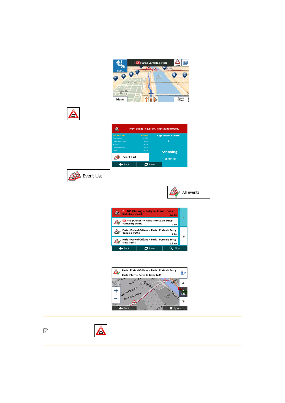
2.3.3.8 Traffic events
If there are traffic events on the recommended route that the application has not
bypassed, the
quickly check them.
Road segments af fected by traffic events are displayed with an a lternate colour on t he map,
and small symbols above the road show the nature of the event:
1. Tap
2. Tap
3. Tap the traffic category you are interested in, or tap
of all events:
4. Now tap any of the list items to see its details, and to display the affected road
segment in its full length on the map:
to open the Traffic Summary screen.
to open the list of event categories.
to see the list
Note!
icon will open the list of significant traffic events to let you
19
Page 20
2.3.4 Manipulating the map
Action
Button(s)
Description
Moving the
No buttons
You can move the map in any direction: tap and hold
the map, and move your finger towards the direction
Zooming in
Changes how much of the map is displayed on the
y vector maps that let you
examine the map at various zoom levels, always with
optimised content. It always displays street nam es and
down,
has a limit in 3D map view mode. If you
tap and hold the button to modify it continuously and
Tilting up and
in large steps, or
tap and hold the button to modify it continuously and
Rotating left
tap and hold the button to modify it continuously and
2D or 3D view
Tap this button to switch between the 3D perspective
Compass in
The direction of the compass shows North. Tap the
up view, and then tap again to
Compass in
The direction of the compass shows North. Tap the
up view, and then tap again to
Tap the map anywhere to br owse it during navigation. The map stops following the current
position (the Veh imark er, a blue ar row b y default, is not l ocked in a fix position o n the sc reen
any more) and control buttons appear to help you modify the map view.
map with
drag&drop
and out
down
,
,
you want to move the map.
screen.
Mappy PND uses high-qualit
other text with the sam e font size, never upsideand you only see the streets and objects that you need.
Map scaling
zoom out further, the map switches to 2D view mode.
Tap the button once to modify the view in large steps , or
smoothly.
Changes the vertical view angle of the map in 3D mode.
Tap the button once to modify the view
and right
,
,
2D map view
mode
3D map view
mode
,
,
smoothly.
Changes the horizontal view angle of the map.
Tap the button once to modify the view in large steps , or
smoothly.
and 2D top-down map view modes.
button to switch to N orthrotate the map in the previous direction.
button to switch to N orthrotate the map in the previous direction.
20
Page 21
Location
information
Tap this button to o pen a new screen with inform ation
Return to
Tap this button to move the map back to follow the
Additional
Tap this button to open a l ist of additional features like
saving the Cursor as a Favourite destination, or
Select
Tap this button to select the Cursor as a new
Button
Description
Shortcut for
Master
olume of the dev ice.
More / Settings / Sound
and Warnings / Volume
This switch mutes all sounds of the application. Tap
More / Settings / Sound
about the selected map point, the Cursor.
normal
navigation
options
destination
current GPS position. A utom atic map r otation is also r eenabled.
The map manipulation but t ons disap pear a nd na v igat i on
continues.
searching for Places around the Cursor.
destination. The route is automatically calculated.
2.3.5 Quick menu
The Quick menu is a selection of controls and functions that are frequently needed during
navigation. It can be opened directly from the Map screen by tapping
.
The menu will close after a few seconds of inactivity or if you tap
The menu will also close if you initiate sim ple controls like muting th e device. In other cases
tapping a button will open a new screen with options.
Most of these functions are shortcuts. They are accessible from the menu system.
There are more f unctions availabl e than the num ber of buttons in the menu. I n Settings, you
can choose the function of each button (page 90). The following options are available:
Volume slider
,
This slider adjusts the sound v
All sounds of the application are affected.
again to re-enable sounds.
.
/ Master slider
and Warnings / Volume
/ Master switch
21
Page 22
This button opens the Combined Search function
that allows you to search addresses, Places,
Favourite and recent destinations by name in one
Destination (page 26)
This function lets you search for a Place by its
name. The search is carried out either along your
your current location if there is no
Destination / Find
This button opens the list of your Favourite
Find / Favourite (page
on opens the History list. You can select
Find / History (page 58)
My Route / Edit Route
More / Settings / Route
More / Settings / Map
rch for
nearby emergency or roadside assistance. For
Tap the Current Street
ncels the route and stops na vigation.
My Route / Cancel
n/a
My Route / Overview
More / Settings / Visual
unified environment.
route or around
route calculated.
Places / Quick Search
44)
(page
destinations.
This butt
one of your previous destinations .
This button opens the route editing function.
This button opens the route related settings.
This button opens the map related settings.
This button opens a speci al screen with information
about the current positi on and a button to s ea
details, see the next chapter.
56)
Settings (page 91)
Settings (page 96)
field on the Map screen
This button ca
The button is rep laced with t he next one if waypoints
are given.
This button skips the next waypoint from the route.
This button opens a 2D m ap scaled and positioned
to show the entire route.
This button opens the Visual Guidance settings
screen.
Route (page 66)
(page 61)
Guidance (page 97)
22
Page 23

This button opens the Traffic Summary screen.
Tap the Traffic icon in
This button lets you bypass parts of the
My Route / Avoidances
This button opens the Trip Monitor screen where
More / Trip Monitor
This button opens the list of manoeuvres (the
Tap the top of the Map
With this function you can s ave the active route for
My Route / More / Save
With this function you can replace the active route
My Route / More / Load
With this function you can search for Places of
Find / Find Places (page
This button opens the Map screen and starts
My Route / More /
Tap the top of the Map
This button opens the parameters of the selected
More / Settings / Route
recommended route.
the Navigation menu or
on the Map screen
you can manage your previ ously saved trip logs and
track logs.
itinerary).
later use.
with a previously saved route.
Interest in various different ways.
simulating the active route.
(page 86)
screen during
navigation.
Route
Route
44)
Simulate Navigation
74)
(page
This button opens the G PS Information screen with
satellite position and signal strength information.
Vehicle profile.
screen when there is no
GPS reception
(page 91)
23
Page 24
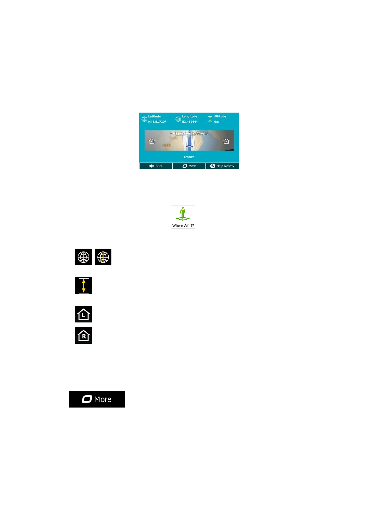
2.3.6 Checking the details of the current position (Where Am I?)
This screen contains inf orm atio n ab out th e cur r ent p os ition ( or a bout the last known position if
GPS reception is not available) and a button to search for useful Places nearby.
You can access this screen from the map in one of the following ways:
• If the current street is displayed below the Vehimarker (the current position on the
map), tap it to open the Where Am I? screen.
• Open the Quick menu and tap the
Information on this screen:
•
•
•
•
, : Latitude and Longitude (coordinate of the current position in WGS84
format).
: Altitude (elevation information coming from the GPS receiver - often
inaccurate).
: House number on the left.
: House number on the right.
button.
• In the middle of the screen you can see whether the position is current, or the time left
since it was last updated.
• Address details (when available) of the current position are displayed at the bottom.
You can also perform some actions on this screen:
Tap
to save the current position as a Favourite destination.
24
Page 25
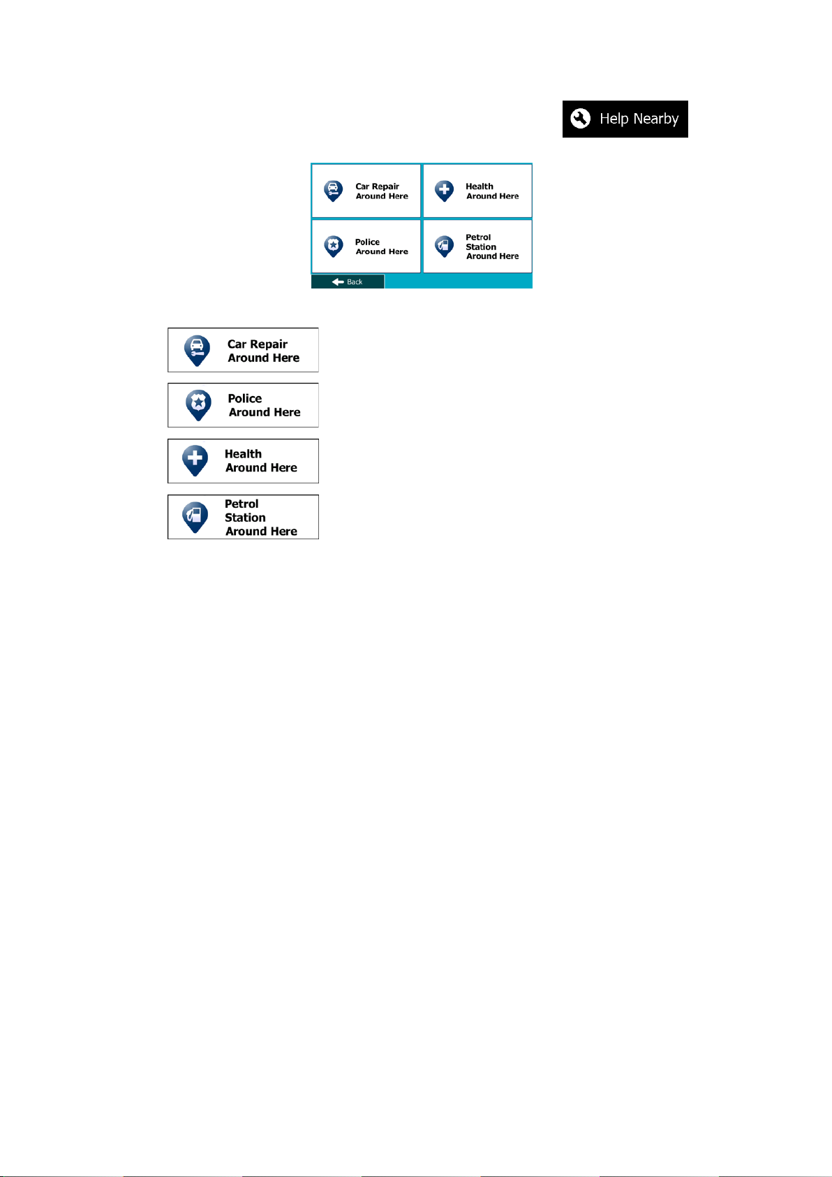
You can also search for assistance near your current position. Tap to
open a new screen for the Quick search:
The following services can be searched around the current position or the last known position:
• : Car repair and roadside assistance services
•
• : Medical and emergency services
•
Tap any of the buttons, select a Place from the list, and navigate to it.
: Police stations
: Petrol stations
25
Page 26

3 On-road navigation
When first started, Mapp y PND calculates routes using the road ne twork of the high quality
vector maps provided with the product.
You can set up your route in different ways:
• If you need a route for immediate navigation, you can select the destination and start
navigating to it right away (normal navigation).
• You can also plan a route independently of your current GPS position or even without
GPS reception. To achieve this you need to set a new starting point in My Route / Edit
Route by tapping the flag icon at the current position. This will also turn off the GPS
receiver so that the route is not recalculated when a new position is received.
You can plan routes with multiple destinations. Select the first destination. Then select a
second destination and add it to your route to create a multi-point route. You can add as
many destinations to your route as you lik e.
You can also use Mappy PND for off-road navigation. For details, see page 76.
3.1 Selecting the destination of a route
Mappy PND offers you several ways of choos ing your dest inati on:
• Enter a full address or a part of an address, for example a street name without a house
number or the names of two intersecting streets (page 35).
• Enter an address with postal code (page 42). This way you do not need to select the
name of the city/town and the search for street names might be faster as well.
• Use a built-in Place of Interest as your destination (page 44).
• Select a location on the map with the Find on Map feature (page 55).
• Use a previously saved Favourite destination (page 56).
• Select a location from the History of previously used destinations (page 58).
• Enter the coordinate of the destination (page 59).
3.1.1 Combined Search
There are several ways to select the destination of the route. You can find buttons in the
Destination menu that initi ate a separate search for addresses, Places, Fav ourite or recent
destinations. The f astest way to search for any of th ese is to use the Combined Search. In
this section you can find the full description of how this feature works. The below process
shows how to carr y out the searc h and the following subsections wil l help you find specific
kinds of results.
1. In the Navigation menu, tap
2. Tap the horizontal input field above the buttons. The Combined Search screen
appears.
26
.
Page 27
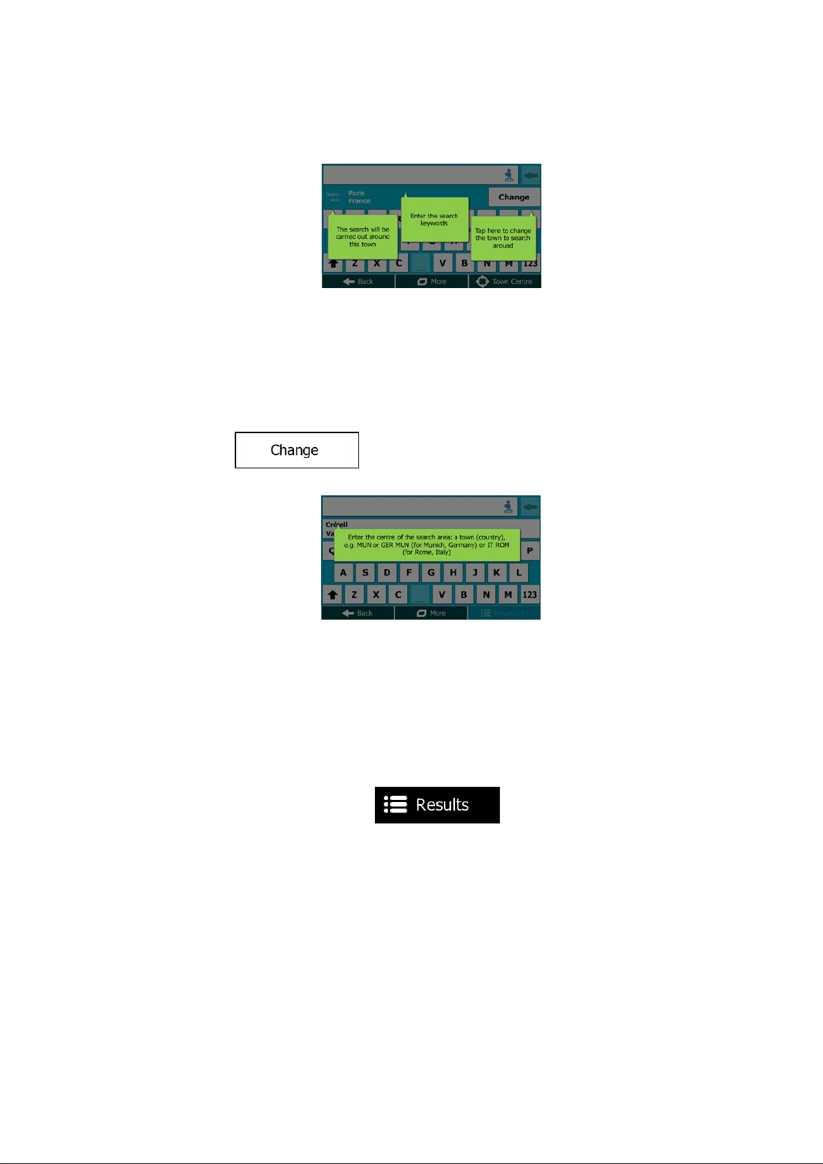
3. First you see hints on the screen showing how you can use the function. These hints
are only displayed the first time you use this screen.
4. Tap anywhere and the hints disappear. Once you get through this screen to the search
results, the hint will not appear again when you open this window later but you can see
them again if you tap the information button on the right side of the input field.
5. You can see the input field at the top of the screen. Right below that you see the
search area, the city/town around which the search is carried out. The default search
area is the area where you are located. For a local search, skip the next step.
6. (optional) To search in a different area, do as follows:
1. Tap
bubble explains how you can specify the ne w searc h c entre.
2. Tap anywhere and the hint disappears. If you successfully select a new search
area, the hint will not appear again when you open this wind o w later but you can
see it again if you tap the information button on the right side of the input field.
3. Start entering the centre of the new search area us in g the scr een keyboard. You
only need to enter a few letters to get a result. If the new search area is in a
different country, you can narrow the search results if you enter one space and
then a few letters of the country of the search area.
4. The most likely result appears below the input field as you enter new letters.
Tap to select this as your new search area. If you cannot see your preferred
area after a few letters, tap
. A new screen opens with a new input field. A hint
and select one from the list.
27
Page 28
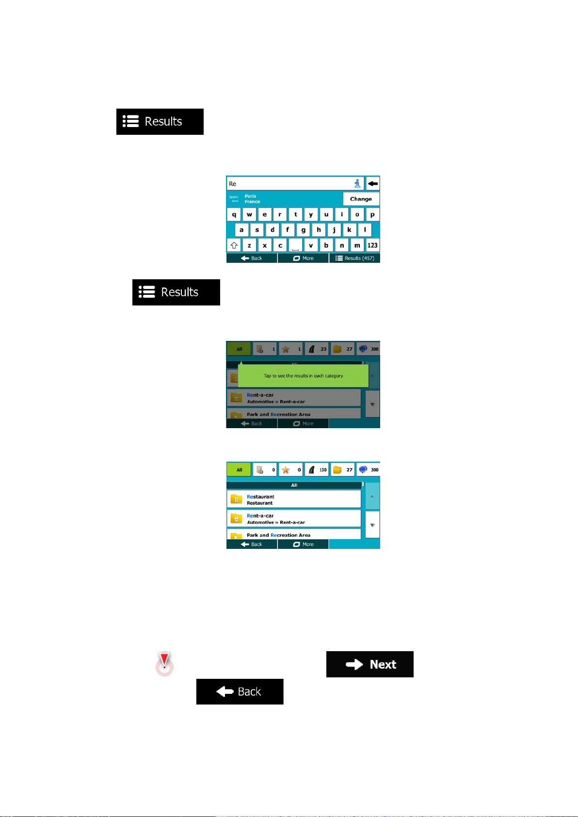
7. With the proper search area displayed, you can start entering the name, address or
category of the destination you are looking for. The number shown in the
button shows how many results match the entered text. The
background search is carried out while you enter letters so this number may keep on
increasing if you wait a few seconds. Keep on entering new letters while this number is
high.
8. Once the number of results is acceptable after a few seconds of searching, you can
tap
9. The result screen also opens with hints. Tap anywhere to suppress them. Once you
select a destination, they will not appear agai n.
10. You see all results in the list, regardless of their type. Addresses, Places, Place
categories, Favourite and recent destinations are mixed within one list.
11. You have the following options:
• Tap the result you want to use as your destination. Sc roll the list if neces sary.
to switch to the result screen.
• To narrow the search for only one type of result (for example for Places only)
you can tap the related button at the top of the screen. See the next sections for
details.
12. Once the destination is selected, a full screen map appears with the selected point in
the middle. If necessary, tap the map somewhere else to modify the destination. The
Cursor (
destination, or tap
) appears at the new location. Tap to confirm the
to select a different destination.
28
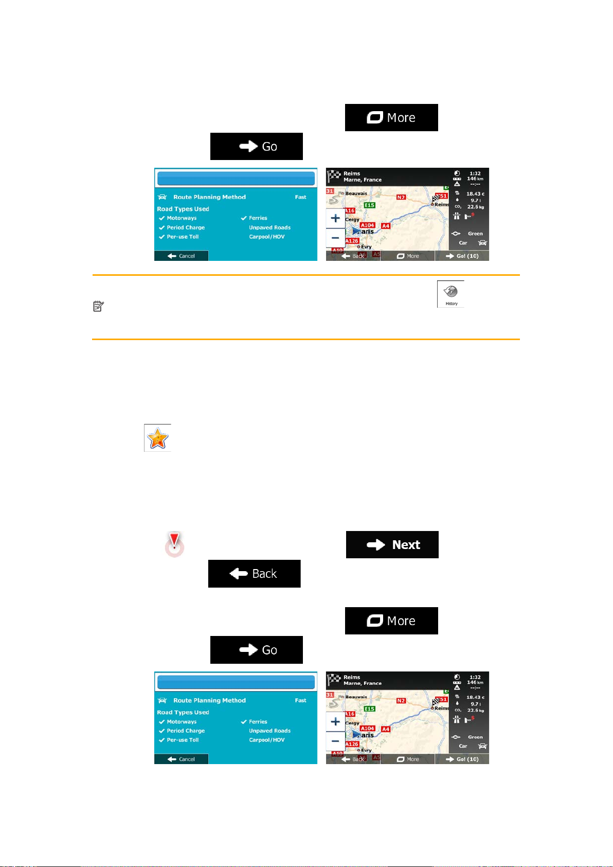
Page 29
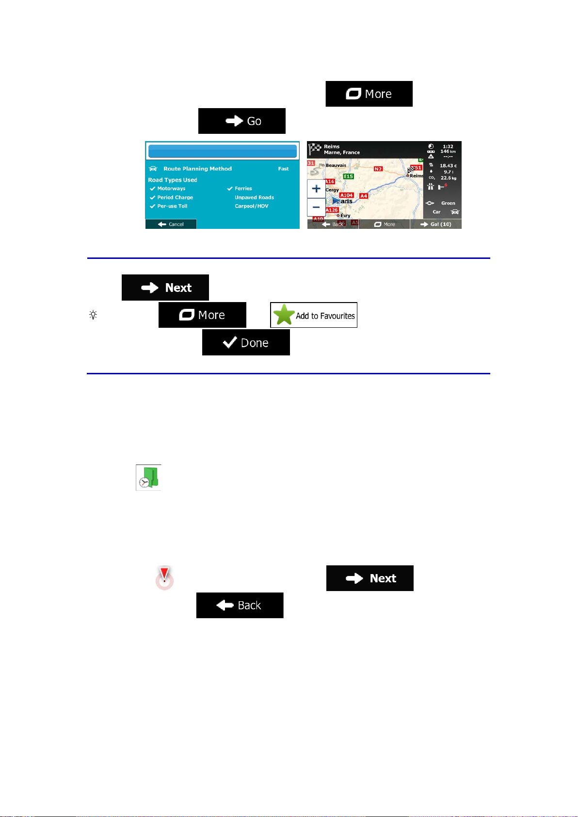
13. After a short summary of the route parameters, the map appears showing the entire
If you know that you will use this destination frequently, before tapping
first: tap
Favourite, a
destination returns automatically. Now you can start your journey.
route. The route is automatically calculated. Tap
parameters, or tap
to confirm the destination, put it on the list of your Favourites
Tip!
nd tap to save the location. The map with the
then , give a name for the new
to modify route
and start your journey.
3.1.1.1 Combined Search - Navigating to a recent destination (History)
To find one of your recent destinations in Combined Search, carry out the search as
described earlier. For th e input text you can use either a part of the n ame or a part of the
address of the recent destination. When you get to the result screen, do as follows:
1. Tap
2. The list is now filtered. What you see is the list of recent destinations with a matching
name or address.
3. Scroll down the list if necessary and then select one of the destinations from the list.
4. Once the destination is selected, a full screen map appears with the selected point in
the middle. If necessary, tap the map somewhere else to modify the destination. T he
Cursor (
destination, or tap
at the top of the screen.
) appears at the new location. Tap to confirm the
to select a different destination.
29
Page 30
The alternative way to search for a recent destination is to tap the
th
the above.
5. After a short summary of the route parameters, the map appears showing the entire
route. The route is automatically calculated. Tap
parameters, or tap
Note!
e Quick menu or in the Destination menu. The rest of the procedure is similar to
and start your journey.
to modify route
button in
3.1.1.2 Combined Search - Navigating to a Favourite destination
To find one of your Favourite destinations in Combined Search, carry out the search as
described earlier. When you get to the result screen, do as follows:
1. Tap
2. The list is now filtered. What you see is the list of your Favour ite dest inat io ns with a
matching name.
3. Scroll down the list if necessary and then select one of the destinations from the list.
4. Once the destination is selected, a full screen map appears with the selected point in
the middle. If necessary, tap the map somewhere else to modify the destination. The
Cursor (
destination, or tap
5. After a short summary of the route parameters, the map appears showing the entire
route. The route is automatically calculated. Tap
parameters, or tap
at the top of the screen.
) appears at the new location. Tap to confirm the
to select a different destination.
to modify route
and start your journey.
30
Page 31

Note!
The alternative way to search for a Favourite destination is to tap the
button
in the Quick menu or in the Destination menu. The rest of the procedure is similar
to the above.
The alternative way to search for an address is to tap the
Destination menu. Unlike the Combined Search, this alternative search method is a
structured one where you can define the parts of the address separately.
3.1.1.3 Combined Search - Navigating to an address
To find an address in Combined Se arch, carry out the search as described earl ier. Use the
name of the street alone or com bined with the house number as your input text . When you
get to the result screen, do as follows:
1. Tap
2. The list is now filtered. What you see is the list of matching addresses.
3. Scroll down the list if necessary and then select one of the addresses from the list.
4. Once the destination is selected, a full screen map appears with the selected point in
the middle. If necessary, tap the map somewhere else to modify the destination. The
Cursor (
destination, or tap
5. After a short summary of the route parameters, the map appears showing the entire
route. The route is automatically calculated. Tap
parameters, or tap
at the top of the screen.
) appears at the new location. Tap to confirm the
to select a different destination.
to modify route
and start your journey.
Note!
31
button in the
Page 32

3.1.1.4 Combined Search - Navigating to an intersection
The alternative way to search for an address is to tap the
Destination menu. Unlike the Combined Search, this alternative search method is a
structured one where you can define the parts of the address sepa
To find an intersec tion i n Com bined Search, carr y out the se arch as desc ribed e ar lier but use
the '&' sign to s eparate the two intersecting streets. You do not need t o use spaces before
and after the separat or cha rac ter. For ex am ple you can us e an y of the follow ing input t exts to
find the intersections of Col lins Street and Doug las Avenue (the m ore precise the input strin g
the fewer false results are expected):
• Collins St & Douglas Ave
• Collins & Douglas
• Coll St & Dou Av
• Col&Doug
• C&D
• Collins St& (this one will give you all the intersections of Collins Street so that you can
select the appropriate one from the result list)
When you get to the result screen, do as follows:
1. Tap
2. The list is now filtered. What you see is the list of matching intersections.
3. Scroll down the list if necessary and then select one intersection from the list.
4. Once the destination is selected, a full screen map appears with the selected point in
the middle. If necessary, tap the map somewhere else to modify the destination. The
Cursor (
destination, or tap
5. After a short summary of the route parameters, the map appears showing the entire
route. The route is automatically calculated. Tap
parameters, or tap
at the top of the screen.
) appears at the new location. Tap to confirm the
to select a different destination.
to modify route
and start your journey.
Note!
32
button in the
rately.
Page 33

3.1.1.5 Combined Search - Navigating to a Place of Interest
The alternative way to search for a Place is to tap the
menu or the
from the Combined Search. The first one is also a name search but if there is a
route planned, it will not be carried out around your current location but along the
route. The Place search in the Destination menu is a complex Place search with
se
current route.
To find a Place of Interest in Combined Search, carry out the search as described earlier.
Search for a part of its name. When you get to the result screen, do as follows:
1. Tap
2. The list is now filtered. What you see is the list of matching Places ordered by their
distance from your current location.
3. (optional) Should your product contain Places from different data providers, you can
further narrow the list by showing Places from one provider only. Look for the provider
logos at the top of the screen. Tap one of them to see Places from that provider only.
4. Scroll down the list if necessary and then select one of the Places from the list.
5. Once the destination is selected, a full screen map appears with the selected point in
the middle. If necessary, tap the map somewhere else to modify the destination. The
Cursor (
destination, or tap
6. After a short summary of the route parameters, the map appears showing the entire
at the top of the screen.
) appears at the new location. Tap to confirm the
to select a different destination.
route. The route is automatically calculated. Tap
parameters, or tap
Note!
veral options including category search or search around the destination of the
button in the Destination menu. These alternatives are different
to modify route
and start your journey.
button in the Quick
33
Page 34

3.1.1.6 Combined Search - Navigating to a Place of Interest by its category
The alternative way to search for a Place category is to tap the
Destination menu and then tap
Combined Search. When you search for a Place category here, you will go t
the whole Place category tree. When you select a category, the list of its
subcategories opens.
To find a Place of Interest in Combined Search by giving its category only, carry out the
search as described earlier. Search for a part of the category name. When you get to the
result screen, do as follows:
1. The list is ordered with Place categories at the beginning but if you want, you can filter
the list to contain Place categories only. Tap
list.
2. Scroll the list and select one of the categories. You get the list of Places in that
category ordered by their distance from your current position. If the selected category
contains subcategories, you will see all Places in that category mixed into one list.
3. (optional) Should your product contain Places from different data providers, you can
further narrow the list by showing Places from one provider only. Look for the provider
logos at the top of the screen. Tap one of them to see Places from that provider only.
4. Scroll down the list if necessary and then select one of the Places from the list.
5. Once the destination is selected, a full screen map appears with the selected point in
the middle. If necessary, tap the map somewhere else to m odify the destination. The
Cursor (
) appears at the new location. Tap to confirm the
at the top of the screen to filter the
destination, or tap
6. After a short summary of the route parameters, the map appears showing the entire
route. The route is automatically calculated. Tap
parameters, or tap
Note!
to select a different destination.
to modify route
and start your journey.
button in the
. This alternative is different from the
hrough
34
Page 35

3.1.2 Entering an address or a part of the address
If you know at least a par t of t he ad dres s , it is the qu ic kest way to select the dest i nati on of the
route.
Using the same screen, you can find an address by entering:
• the exact address, including house number
• the centre of a city/town
• an intersection
• the midpoint of a street
• any of the above, starting the search with the postal code (page 42)
3.1.2.1 Entering an address
To enter an address as the destination, do as follows:
1. If you are on the Map screen, tap
menu.
2. In the Navigation menu, tap the following buttons:
3. By default, Mappy PND proposes the country and city/town where you are. If needed,
tap
keyboard, and select one country from the list of results.
4. If needed, select a new city/town:
a. Tap
b. Start entering the name of the city/town on the keyboard.
, enter the first few letters of the country name on the
.
to return to the Navigation
, .
c. Find the city/town you need:
• The most likely city/town name is always shown in the input field. To
accept it, tap
.
35
Page 36

• If the desired nam e does not show up, the names that match the s tring
appear in a list after entering a couple of characters (to open the list of
results before it appear s automatically, tap
the city/town from the list.
5. Enter the street name:
a. Tap
b. Start entering the street name on the keyboard.
c. Find the street you need:
• The most likely street nam e is always shown in t he input field. T o accept
it, tap
• If the desired nam e does not show up, the names that match the s tring
appear in a list after entering a couple of characters (to open the list of
.
.
). Select
results before it appear s automatically, tap
the street from the list.
6. Enter the house number:
a. Tap
b. Enter the house number on the keyboard. (To enter letters, tap
.
). Select
).
36
Page 37

c. Tap
number cannot be found, the midpoint of the street is selected as the
destination.)
7. A full screen map appears with the selected point in the middle. If necessary, tap the
map somewhere else to modify the destination. The Cursor (
location. Tap
to select a different destination.
8. After a short summary of the route parameters, the map appears showing the entire
route. The route is automatically calculated. Tap
to finish entering the address. (If the entered house
) appears at the new
to confirm the destination, or tap
to modify route
parameters, or tap
and start your journey.
3.1.2.2 Entering the midpoint of a street as the destination
You can navigate to the midpoint of a street if the house number is not available:
1. If you are on the Map screen, tap
menu.
2. In the Navigation menu, tap the following buttons:
3. If necessary, modify the country and city/town as described earlier (page 35).
to return to the Navigation
, .
4. Enter the street name:
a. Tap
.
37
Page 38

b. Start entering the street name on the keyboard.
c. Find the street you need:
• The most likely street nam e is always shown in t he input field. T o accept
it, tap
• If the desired nam e does not show up, the names that match the string
appear in a list after entering a couple of characters (to open the list of
results before it appear s automatically, tap
the street from the list.
5. Instead of entering the house number, tap
street is selected as the destination.
.
). Select
. The midpoint of the
6. A full screen map appears with the selected point in the middle. If necessary, tap the
map somewhere else to modify the destination. The Cursor (
location. Tap
to select a different destination.
7. After a short summary of the route parameters, the map appears showing the entire
route. The route is automatically calculated. Tap
parameters, or tap
to confirm the destination, or tap
and start your journey.
) appears at the new
to modify route
38
Page 39

3.1.2.3 Selecting an intersection as the destination
To enter an address as the destination, do as follows:
1. If you are on the Map screen, tap
menu.
2. In the Navigation menu, tap the following buttons:
3. If necessary, modify the country and city/town as described earlier (page 35).
4. Enter the street name:
a. Tap
b. Start entering the street name on the keyboard.
c. Find the street you need:
• The most likely street nam e is always shown in t he input field. To accept
it, tap
• If the desired nam e does not show up, the names that match the s tring
appear in a list after entering a couple of characters (to open the list of
results before it appear s automatically, tap
the street from the list.
.
.
to return to the Navigation
, .
). Select
5. Enter the intersecting street name:
1. Tap
• If only a few intersecting streets exist, their list appears immediately.
• In case of a longer str eet, the keyboard screen appears . Start entering
the name of the intersecting street on the keyboard. As soon as the street
names that match the ente red string can be shown on one sc reen, their
list appears automatically. Select from the list.
.
39
Page 40

6. A full screen map appears with the selected point in the middle. If necessary, tap the
map somewhere else to modify the destination. The Cursor (
location. Tap
to select a different destination.
7. After a short summary of the route parameters, the map appears showing the entire
route. The route is automatically calculated. Tap
parameters, or tap
to confirm the destination, or tap
and start your journey.
) appears at the new
to modify route
3.1.2.4 Selecting a city/town centre as the destination
The city/town centre is not the geom etric cent re of t he cit y/to wn but an arbitrary point the map
creators have chosen . In towns and villages , it is usually the m ost important intersection; in
larger cities, it is one of the important intersections.
1. If you are on the Map screen, tap
menu.
2. In the Navigation menu, tap the following buttons:
3. If necessary, modify the country as described earlier (page 35).
4. Select the destination city/town:
a. Tap
b. Start entering the name of the city/town on the keyboard.
c. Find the city/town you need:
• The most likely city/town name is always shown in the input field. To
accept it, tap
.
.
to return to the Navigation
, .
40
Page 41

• If the desired nam e does not show up, the names that match the s tring
appear in a list after entering a couple of character s (to open the list of
results before it appear s automatically, tap
the city/town from the list.
5. Instead of entering the street name, tap
the displayed city/town becomes the destination of the route.
6. A full screen map appears with the selected point in the middle. If necessary, tap the
. This way the centre of
). Select
map somewhere else to modify the destination. The Cursor (
location. Tap
to select a different destination.
7. After a short summary of the route parameters, the map appears showing the entire
route. The route is automatically calculated. Tap
parameters, or tap
to confirm the destination, or tap
and start your journey.
) appears at the new
to modify route
41
Page 42

3.1.2.5 Entering an address with a postal code
All of the above address searching possibilities can be performed with entering the postal
code instead of the city/town name. Find below an example with a full address:
1. If you are on the Map screen, tap
menu.
2. In the Navigation menu, tap the following buttons:
3. If necessary, modify the country as described earlier (page 35).
4. Enter a new city/town using its postal code:
a. Tap
b. Tap
c. Start entering the postal code.
d. Find the city/town you need:
• The most likely postal cod e is always shown i n the input field. T o accept
• If the desired number does not show up, open the list of results by
to open the numeric keypad.
it, tap
tapping
.
.
. Select the postal code from the list.
to return to the Navigation
, .
5. Enter the street name:
a. Tap
b. Start entering the street name on the keyboard.
c. Find the street you need:
• The most likely street nam e is always shown in t he input field. T o accept
it, tap
.
.
42
Page 43

• If the desired nam e does not show up, the names that match the s tring
appear in a list after entering a couple of characters (to open the list of
results before it appear s automatically, tap
the street from the list.
6. Enter the house number:
a. Tap
b. Enter the house number on the keyboard. (To enter letters, tap
c. Tap
number cannot be found, the midpoint of the street is selected as the
destination.)
.
to finish entering the address. (If the entered house
). Select
).
7. A full screen map appears with the selected point in the middle. If necessary, tap the
map somewhere else to modify the destination. The Cursor (
location. Tap
to select a different destination.
8. After a short summary of the route parameters, the map appears showing the entire
route. The route is automatically calculated. Tap
parameters, or tap
to confirm the destination, or tap
and start your journey.
) appears at the new
to modify route
43
Page 44

3.1.2.6 Tips on entering addresses quickly
• When you are entering the name of a city/town or a street:
• Only those letters are offered on the keyboard that appear in possible search
results. All other characters are greyed out.
• As you are typing, the most likely result is always displayed in the input field. If
the guess is correct, tap
• After entering a couple of letters, tap
contain the specified letters.
• You can speed up finding an intersection:
• Search first for the street with a less common or less usual name; fewer letters
are enough to find it.
• If one of the streets is shorter, search for that one first. You can then find the
second one faster.
• You can search for both the type and the name of a road. If the same word appears in
several names, for example in the name of streets, roads and avenues, you can obtain
the result faster if you enter the first letter of the street type: For example, enter 'PI A' to
obtain Pine Avenue and skip all Pine Streets and Pickwick Roads.
• You can also search in postal codes. As postal codes consist of only a few characters,
this is usually faster than entering the name of the city/town.
to select it.
to list the items that
3.1.3 Selecting the destination from the Places of Interest
You can select your destination from the Places of Interest included with Mappy PND.
Using the same screen, you can find a Place in different ways:
• with the Quick search feature, you can quickly find a nearby Place by its name
• with the Preset search feature, you can find frequently searched types of Places with
only a few screen taps
• you can search for a Place by its category
• you can search for a Place by its name
In addition, you can search for special services from the 'Where Am I?' screen.
3.1.3.1 Quick search for a Place of Interest
The Quick search feature lets you quickly find a Place by its name. The search is always
carried out
• along the recommended route if it exists or
• around your current location if there is no destination given.
1. Start the Quick search function:
• If you are on the Map screen, tap and then tap .
44
Page 45

• If you are in the Navigat ion menu, tap , and then
tap
2. Using the keyboard, start entering the name of the Place.
3. After entering a few letters, tap
names containing the entered character sequence.
4. (optional) The Places in the list are ordered by the length of the necessary detour
(when navigating a route) or by their distance from the current position (when no
.
to open the list of Places with
destination is given). If you need to reorder the list, tap
5. Browse the list if necessary and tap one of the list items. A full screen map appears
with the selected point in the middle. The name and address of the Place is displayed
at the top of the screen.
6. (optional) Tap
to return to the map.
7. If necessary, tap the map somewhere else to modify the destination. The Cursor
) appears at the new location. Tap to confirm the
(
destination, or tap
to see the details of the selected Place. Tap
to select a different destination.
.
45
Page 46

8. After a short summary of the route parameters, the map appears showing the entire
route. The route is automatically calculated. Tap
parameters, or tap
and start your journey.
to modify route
3.1.3.2 Searching for a Place of Interest using preset categories
The Preset search feature lets you quickly find the most frequently selected types of Places.
1. If you are on the Map screen, tap
menu.
2. In the Navigation menu, tap the following buttons:
to return to the Navigation
, .
3. The preset search categories appear:
•
• If an active route exists, petrol stations are searched along the route.
• If there is no active route ( destination is not select ed), they are se arched
around the current position.
• If the current position is not available either (no GPS signal), they are
searched around the last known position.
•
• If an active route exists, pa rking lots are sear ched aro und the desti nation
of the route.
• If there is no active route ( destination is not select ed), they are se arched
around the current position.
:
:
46
Page 47

• If the current position is not available either (no GPS signal), they are
searched around the last known position.
•
• If an active route exists, restaurants are searched along the route.
• If there is no active route ( destination is not select ed), they are se arched
around the current position.
• If the current position is not available either (no GPS signal), they are
searched around the last known position.
•
• If an active route exists, accommodation is searched around the
destination of the route.
• If there is no active route ( destination is not select ed), they are se arched
around the current position.
• If the current position is not available either (no GPS signal), they are
searched around the last known position.
4. Tap any of the quick search buttons to get an instant list of Places.
:
:
5. (optional) The Places in the list are ordered by their distance from the current or last
known position, from the destination or by the length of the necessary detour. If you
need to reorder the list, tap
6. Browse the list if necessary and tap one of the list items. A full screen map appears
with the selected point in the middle. The name and address of the Place is displayed
at the top of the screen.
7. (optional) Tap
to return to the map.
8. If necessary, tap the map somewhere else to modify the destination. The Cursor
) appears at the new location. Tap to confirm the
(
destination, or tap
to see the details of the selected Place. Tap
to select a different destination.
.
47
Page 48

9. After a short summary of the route parameters, the map appears showing the entire
route. The route is automatically calculated. Tap
parameters, or tap
and start your journey.
3.1.3.3 Searching for a Place of Interest by category
You can search for Places of Interest by their categories and subcategories.
1. If you are on the Map screen, tap
menu.
2. In the Navigation menu, tap the following buttons:
to return to the Navigation
to modify route
, .
3. Tap
4. Select the area around which the Place should be searched for:
• Tap
• Tap
• Tap
.
to search around the current position or if it is not
available, around the last know position. (The result list will be ordered by the
distance from this position.)
to search for a place within a selected city/town. (The
result list will be ordered by the distance from the centre of the selected
city/town.)
to search for a place around the destination of the
active route. (The result list will be ordered by the distance from the destination.)
48
Page 49

• Tap
given point. This is useful when you search for a later stopover that results in a
minimal detour only, such as searching for upcoming petrol stations or
restaurants. (The result list will be ordered by the length of the necessary
detour.)
5. (optional) If you have selected
to search along the active route, and not around a
, select the city/town to search in.
6. Select one of the main Place categories (e.g. Accommodation) or tap
to list all Places around the selected location or along the route.
7. Select one of the Place subcategories (e.g. Hotel or Motel) or tap
to list all Places in the selected main category around the selected location or along the
route.
49
Page 50

8. Sometimes the list of brands in the selected Place subcategory appears. Select one
brand or tap
the selected location or along the route.
9. Finally, the results appear in a list.
10. (optional) The Places in the list are ordered by their distance from the current or last
known position, from the selected city/town, from the destination or by the length of the
necessary detour. If you need to reorder the list, tap
to list all Places in the selected subcategory around
.
11. Browse the list if necessary and tap one of the list items. A full screen map appears
with the selected point in the middle. The name and address of the Place is displayed
at the top of the screen.
12. (optional) Tap
to return to the map.
13. If necessary, tap the map somewhere else to modify the destination. The Cursor
) appears at the new location. Tap to confirm the
(
destination, or tap
14. After a short summary of the route parameters, the map appears showing the entire
route. The route is automatically calculated. Tap
parameters, or tap
to see the details of the selected Place. Tap
to select a different destination.
to modify route
and start your journey.
50
Page 51

3.1.3.4 Searching for a Place of Interest by name
You can search for Places of Interest by their names. You can search around different
locations or along your route in the whole Place database or in one Place category or
subcategory only.
1. If you are on the Map screen, tap
menu.
2. In the Navigation menu, tap the following buttons:
3. Tap
4. Select the area around which the Place should be searched for:
• Tap
• Tap
• Tap
.
to search around the current position or if it is not
available, around the last know position. (The result list will be ordered by the
distance from this position.)
to search for a place within a selected city/town. (The
result list will be ordered by the distance from the centre of the selected
city/town.)
to search for a place around the destination of the
active route. (The result list will be ordered by the distance from the destination.)
to return to the Navigation
, .
• Tap
given point. This is useful when you search for a later stopover that results in a
minimal detour only, such as searching for upcoming petrol stations or
restaurants. (The result list will be ordered by the length of the necessary
detour.)
5. (optional) If you have selected
to search along the active route, and not around a
, select the city/town to search in.
51
Page 52

6. Select one of the main Place categories (e.g. Accommodation) to search in or tap
to search among all Places.
7. Select one of the Place subcategories (e.g. Hotel or Motel) to search in or tap
to search in the selected Place category.
8. Tap
if you have not done it before.
9. Using the keyboard, start entering the name of the Place.
10. After entering a few letters, tap
names containing the entered character sequence.
to open the list of Places with
52
Page 53

11. (optional) The Places in the list are ordered by their distance from the current or last
known position, from the selected city/town, from the destination or by the length of the
necessary detour. If you need to reorder the list, tap
12. Browse the list if necessary and tap one of the list items. A full screen map appears
with the selected point in the middle. The name and address of the Place is displayed
at the top of the screen.
13. (optional) Tap
to return to the map.
14. If necessary, tap the map somewhere else to modify the destination. The Cursor
) appears at the new location. Tap to confirm the
(
destination, or tap
15. After a short summary of the route parameters, the map appears showing the entire
route. The route is automatically calculated. Tap
parameters, or tap
to see the details of the selected Place. Tap
to select a different destination.
and start your journey.
.
to modify route
3.1.3.5 Selecting nearby assistance from 'Where Am I?'
You can quickly search for nearby assistance from the 'Where Am I?' screen.
1. On the Map screen, tap
to open the Quick menu.
53
Page 54

2. Tap
3. Preset search categories appear, all for searching around the current position (or
around the last known position if the current position is not available):
•
• : Medical and emergency services
•
• : Petrol stations
, and then .
: Car repair and roadside assistance services
: Police stations
4. Tap any of the quick search buttons to get an instant list of that type of Places.
5. (optional) The Places in the list are ordered by their distance from the current or last
known position, from the selected city/town, from the destination or by the length of the
necessary detour. If you need to reorder the list, tap
6. Browse the list if necessary and tap one of the list items. A full screen map appears
with the selected point in the middle. The name and address of the Place is displayed
at the top of the screen.
7. (optional) Tap
to return to the map.
8. If necessary, tap the map somewhere else to modify the destination. The Cursor
) appears at the new location. Tap to confirm the
(
to see the details of the selected Place. Tap
.
destination, or tap
to select a different destination.
54
Page 55

9. After a short summary of the route parameters, the map appears showing the entire
route. The route is automatically calculated. Tap
parameters, or tap
and start your journey.
to modify route
3.1.4 Selecting a map location as the destination
1. If you are on the Map screen, tap to return to the Navigation
menu.
2. In the Navigation menu, tap the following buttons:
, .
3. Locate your destination on the map: move and scale the map as needed.
4. Tap the location that you want to select as your destination. The Cursor (
appears there.
5. Tap
6. After a short summary of the route parameters, the map appears showing the entire
route. The route is automatically calculated. Tap
parameters, or tap
to select the Cursor as the destination.
and start your journey.
)
to modify route
55
Page 56

3.1.5 Selecting the destination from your Favourites
You can select a location t hat you have alread y saved as a Favourite to be your destination.
Adding a location to the list of Favourite destinations is described on page 71.
1. Access the list of Favourites:
• If you are on the Map screen, tap
• If you are in the Navigation menu, tap
2. Tap
3. Tap the Favourite that you want to set as your destination. If necessary, browse down
to see more of the list or tap
name of the Favourite destination.
4. A full screen map appears with the selected point in the middle. If necessary, tap the
map somewhere else to modify the destination. The Cursor (
. The list of Favourite destinations is displayed.
to open the Quick menu.
.
and enter a few letters from the
) appears at the new
location. Tap
to select a different destination.
5. After a short summary of the route parameters, the map appears showing the entire
route. The route is automatically calculated. Tap
parameters, or tap
to confirm the destination, or tap
to modify route
and start your journey.
56
Page 57

3.1.6 Selecting one of the most likely destinations (Smart History)
The destinations that you have set earlier appear in the History list. Two of those recent
destinations are shown in t he Destination menu for eas y access. Smart History offers thes e
locations based on your navigation habits, usin g parameters like the cur rent time of day, the
day of week, and the current locat ion. The m ore you use the naviga tion sof tware, the better it
can guess your desired destination.
1. If you are on the Map screen, tap
menu.
2. In the Navigation menu, tap
3. Tap the
4. A full screen map appears with the selected point in the middle. If necessary, tap the
map somewhere else to modify the destination. The Cursor (
location. Tap
or the destination in the History field.
to confirm the destination, or tap
to select a different destination.
to return to the Navigation
.
) appears at the new
5. After a short summary of the route parameters, the map appears showing the entire
route. The route is automatically calculated. Tap
parameters, or tap
and start your journey.
57
to modify route
Page 58

3.1.7 Selecting a recent destination from the History
The destinations that you have set earlier appear in the History.
1. Access the History:
• If you are on the Map screen, tap
• If you are in the Navigation menu, tap
.
2. The list of recent destinations appears. Smart History promotes three destinations to
the first page based on your previous routes (most likely destinations). The rest of the
destinations are ordered by time they were last selected. If necessary, scroll the list to
see earlier destinations.
3. Select a destination from the list.
4. A full screen map appears with the selected point in the middle. If necessary, tap the
map somewhere else to modify the destination. The Cursor (
and then tap .
and then tap
) appears at the new
location. Tap
to select a different destination.
5. After a short summary of the route parameters, the map appears showing the entire
route. The route is automatically calculated. Tap
parameters, or tap
to confirm the destination, or tap
to modify route
and start your journey.
58
Page 59

3.1.8 Entering the coordinate of the destination
You can also select a destination by entering its coordinate. Do as follows:
1. If you are on the Map screen, tap
menu.
2. In the Navigation menu, tap
3. Open the
4. You can enter the latitude and longitude values in any of the following formats: decimal
degrees; degrees and decimal minutes; or degrees, minutes and decimal seconds.
5. (optional) If necessary, tap
the coordinate in UTM format.
menu and tap .
to return to the Navigation
.
then and enter
6. When finished, tap
7. A full screen map appears with the selected point in the middle. If necessary, tap the
map somewhere else to modify the destination. The Cursor (
location. Tap
to select a different destination.
.
to confirm the destination, or tap
) appears at the new
59
Page 60

8. After a short summary of the route parameters, the map appears showing the entire
route. The route is automatically calculated. Tap
parameters, or tap
and start your journey.
to modify route
3.1.9 Building a route from the list of destinations (Create Route)
You can also build your route destination by destination from the My Route menu.
1. If you are on the Map screen, tap
menu.
2. In the Navigation menu, tap
to return to the Navigation
.
3. Tap
4. There is only one line in the list of route points, the start point of the route, normally the
current GPS position.
5. Tap
6. The Destination menu appears and you can select the destination of the route the
same way as described in the previous sections.
to select the destination.
.
60
Page 61

7. When the new destination is selected, the list returns.
8. To add more destinations, tap
the list, and repeat the above procedure.
where you want to insert the new route point in
3.2 Viewing the entire route on the map
It is easy to get a map overview of the active route. Do as follows:
1. If you are on the Map screen, tap
menu.
2. In the Navigation menu, tap
3. Tap
together with additional info rmation and controls.
. The active route is displayed in its full length on the map
to return to the Navigation
.
3.3 Checking route parameters and accessing route related functions
You can check different parameters of the route recommended by Mappy PND.
1. If you are on the Map screen, tap
menu.
2. In the Navigation menu, tap
3. The following pieces of information are displayed:
61
to return to the Navigation
.
Page 62

• The name and/or address of the destination.
• Warning icons (if any). They provide extra information about your route (e.g.
unpaved roads or toll roads to be taken).
• The total time of the route.
• The total length of the route.
• Estimated delay calculated from traffic events on your route.
• The symbol of the vehicle type used in route calculation.
• The route planning method (e.g. Fast).
4. You have the following options on this screen (for detailed instructions on how to use
them, see the next chapter):
• Tap
change their sequence. You can also set a route start point other than your
current location. This can be useful to plan and save a future trip.
• Tap
• Tap
• Tap
• Tap
route alternatives, changing route parameters, simulating the route, saving the
active route or loading a previously saved route.
• Tap
to edit the route: to add or remove destinations or
to display the entire route on the map.
to bypass a part of the route.
to delete the active route.
to open a list with more options like selecting from
to return to the Navigation menu.
3.4 Modifying the route
When navigation is alr eady started, there are several ways to modif y the active route. T he
following sections show some of those options.
62
Page 63

3.4.1 Selecting a new destination when already having a route: New Route,
Waypoint or Final Destination
If you already have a reco mmended route and you s elect a new destination as described in
the above sections, the application will ask you whether to start a new route, add a new
waypoint (interm ediate destination) to the rout e or append the newl y selected destination at
the end of the current route.
• Tap
destination and waypoint(s) are deleted.
• Tap
route. The other destinations of the route remain intact. Note: the new waypoint is
placed among destinations to keep the route optimal. To decide where a waypoint to
appear, use the Edit Route feature.
• Tap
other destinations of the route remain intact. The previous final destination is now the
last waypoint.
to plan a new route to the newly selected location. The previous
to add the newly selected location as an intermediate destination to your
to append the newly selected destination at the end of the route. The
3.4.2 Setting a new starting position for the route
For normal navigation, all routes are planned from the current position. In order to check
future routes, simulate t hem or see their length in t im e and dis ta nc e, you can turn off the GPS
receiver. Then you can set the starting point of the route to a different location than the
current GPS position.
1. If you are on the Map screen, tap
menu.
2. In the Navigation menu, tap
to return to the Navigation
.
63
Page 64

3. If you already have a route, tap
tap
4. The first line is the start of the route, normally the current GPS position. Tap
confirm your action at the warning message.
.
. If you are starting a new route,
and
5. The Destination menu appears and you can select the start point of the route the same
way you select a destination.
6. When the new start point is set, tap
.
64
Page 65

7. The map returns with a transparent Vehimarker (showing that there is no GPS
reception). If an active route already existed, it is now recalculated starting from the
selected location.
8. To return to normal navigation, tap
.
3.4.3 Editing the list of destinations (Edit Route)
You can edit the route by modifying the list of destinations. You can add or remove
destinations, modify the start position or reorder the list.
1. If you are on the Map screen, tap
menu.
2. In the Navigation menu, tap
3. Tap
.
to return to the Navigation
.
4. You have the following options:
• Tap
• Tap
• Tap
• Tap
let the application optimise the route for you.
to add a new destination.
to delete a destination.
to modify the start point of the route.
to reorder the list. You can do it manually or you can
65
Page 66

3.4.4 Pausing the active route
You do not need to p ause t he act ive rout e: when you start driving a gain, Mapp y PND r estarts
the voice instructions from your position.
3.4.5 Cancelling the active route
To cancel the navigated route, do one of the following:
• If you are on the Map screen, tap
with waypoints, you need to tap
• In the Navigation menu, tap
The active route is deleted with all its waypoints.
and then tap . (If you have a route
until all waypoints are deleted.)
and then tap ..
3.4.6 Checking route alternatives when planning the route
You can select from differ ent route al ter natives or change the route plann in g m ethod af ter you
have selected a new destination. Do as follows:
1. Select a destination as explained earlier, and get to the route confirmation screen.
2. Tap
3. Tap
.
.
66
Page 67

4. You see the basic details of three route alternatives with the selected route planning
method. Tap any of them to see it on the map.
5. Or if you cannot find a good alternative, tap
routes with different routing methods.
6. Select one of the route alternatives and tap
previous screen. Mappy PND recalculates the route. The orange line now shows the
new recommended route.
and scroll down for
to return to the
3.4.7 Checking route alternatives for an existing route
To recalculate the active route with a different route planning method, you can modify the
Route settings (page 91). There is another way to do this and to compare different route
alternatives with the same route planning method. Do as follows:
1. If you are on the Map screen, tap
menu.
2. In the Navigation menu, tap
to return to the Navigation
.
67
Page 68

3. Tap
4. Tap
5. You see the basic details of three route alternatives with the selected route planning
method. Tap any of them to see it on the map.
.
.
6. Or if you cannot find a good alternative, tap
routes with different routing methods.
7. Select one of the route alternatives then tap and hold
seconds to return to the Map screen. Mappy PND recalculates the route. The orange
line now shows the new recommended route.
and scroll down for
for a few
68
Page 69

3.4.8 Changing the vehicle used in route planning
If you select
later, the software warns you w
pedestrian. You are allowed to switch back instantly to
To recalculate the active ro ute for a different vehicle, do as follows. T hese changes can als o
be made in Settings (page 91).
1. On the Map screen, tap
2. Tap
•
•
•
•
and then tap .
and then tap one of the following:
•
•
•
3. Mappy PND recalculates the route optimised for the new vehicle type. The orange line
now shows the new recommended route.
Note!
and you forget to change it back to a vehicle
hen you travel with a speed that is too high for a
.
69
Page 70

3.4.9 Changing the road types used in route planning
To recalculate the active route with different road type preferences, do as follows. These
changes can also be made in Settings (page 91).
1. On the Map screen, tap
2. Tap any of the listed road types to modify the route. If needed, scroll the list for all road
types. You have the following options (their order depends on the selected vehicle
type):
•
a slow car or you are towing another vehicle.
•
pass or vignette to use the road for a longer period of time. They can be
enabled or disabled separately from toll roads.
•
a per-use charge) in the routes by default. If you disable toll roads, Mappy PND
plans the best toll-free route.
and then tap .
- You might need to avoid motorways when you are driving
- Charge roads are pay roads where you can purchase a
- Mappy PND includes toll roads (pay roads where there is
•
However, a map does not necessarily contain information about the accessibility
of temporary ferries. You might also need to pay a fare on ferries.
•
roads can be in a bad condition and usually you cannot reach the speed limit on
them.
•
passengers are travelling in the vehicle. You should check whether you are
allowed to use carpool lanes before enabling this road type.
3. The route has already been recalculated. Tap
screen. The orange line now shows the new recommended route.
- Mappy PND includes ferries in a planned route by default.
- Mappy PND excludes unpaved roads by default: unpaved
- Carpool or HOV lanes can be used if a given number of
70
to return to the Map
Page 71

3.5 Saving a location as a Favourite destination
You can add any loca tion to Favourites, the list of freque ntly used destinations. Planning a
route to one of the Favourite destinations is described on page 56.
1. Select a destination as described before. It can be an address, a Place, any location
on the map, a previously used destination from History, etc.
2. When the full screen map appears with the selected location in the middle, tap
.
3. Tap
4. (optional) Using the keyboard, you can change the name offered for the Favourite. Tap
to enter numbers or symbols.
5. Tap
.
to save the location as a new Favourite destination.
3.5.1 Editing the details of a Favourite destination
You can select a location that you have already saved as a Favourite and edit its details.
Adding a location to the list of Favourite destinations is described on page 71.
1. Access the list of Favourites:
• If you are on the Map screen, tap
• If you are in the Navigation menu, tap
.
and then tap .
and then tap
71
Page 72

2. The list of Favourite destinations is displayed.
3. Tap the Favourite that you want to edit. If necessary, browse down to see more of the
list or tap
destination.
4. A full screen map appears with the selected point in the middle.
5. Tap
6. Tap any of the data fields and modify its content.
7. Tap and hold
to see the details of the selected Place.
and enter a few letters from the name of the Favourite
to return to the map.
3.6 Saving a map location as an alert point
You can save any map loc ation as an alert point (for exam ple a speed camera or a railway
crossing).
1. Browse the map and select a location. The red Cursor appears there.
2. Tap
3. Scroll down the list and tap
.
.
72
Page 73

4. On the newly opened screen, select the type of the alert point, the direction from which
you expect the alert, and (if applicable) the speed limit for this alert point.
5. Tap
to save the location as a new alert point.
3.7 Editing an alert point
You can edit a previous ly saved or uploaded alert point (f or example a speed camera or a
railway crossing).
1. Browse the map and select the alert point to edit. The red circle appears around the
alert point.
2. Tap
.
3. Scroll down the list and tap
4. On the newly opened screen, modify the type of the alert point, the direction from
which you expect the alert, or (if applicable) the speed limit for this alert point.
5. Tap
to save the changes to the alert point.
73
.
Page 74

3.8 Watching the simulation of the route
You can run a simulated navigation that demonstrates the active route. Do as follows:
1. If you are on the Map screen, tap
menu.
2. In the Navigation menu, tap
3. Tap
.
to return to the Navigation
.
4. Scroll down the list and tap
point of the route, and using a realistic speed, it leads you through the whole
recommended route.
1. (optional) You have the following controls during the simulation (the control
buttons disappear after a few seconds but you can open them again if you tap
the map):
•
•
•
: Jump to the next route event (manoeuvre).
: Pause the simulation.
: Jump to the previous route event (manoeuvre).
. The simulation starts from the starting
74
Page 75

• : Tap to increase the speed of the simulation to 4, 8 or 16 times faster.
Now tap again to return to the normal speed.
2. Tap
to stop the simulation.
75
Page 76

4 Off-road navigation
When first started, Mapp y PND calculates routes using the road ne twork of the high quality
vector maps provided with the product. You can switch the application to off-road mode in
Route settings in one of the following ways:
• From the Main menu, tap
.
• From the Map screen, tap
Most of the procedures described for on-road navigation also apply to off-road navigation.
However, there are some that are not available in this navigation mode (for example you
cannot open the itinerary as you have no manoeuvres just route points and straight lines
between them).
, and then .
, , and then
4.1 Selecting the destination of the route
Selecting the start point or a destination (waypoint or final destination) is the same as
described at on-road na vigation. The only difference is that route points are linked to form a
route with straight lines regardless of the road network and traffic regulations.
4.2 Navigating in off-road mode
The real difference between the on-road and off-road modes is the navigation itself. W hen
you are on the Map screen with an off-road route:
• your position and heading is not aligned with the nearest road and
• there is no turn by turn navigation just a recommended direction.
You see a orange line dr awn bet wee n your c urrent pos ition and t he n ext desti nation to reach .
The Turn Preview field in the top left corner shows a compass with your bearing and the
distance of the next destination.
When you reach a waypoint, the orange line will show the direction to t he next destination.
(Future legs of the route are shown with orange lines.)
When you reach the final destination, navigation ends.
76
Page 77

5 Reference Guide
On the following pages you will find the description of the different concepts and menu
screens of Mappy PND.
5.1 Concepts
5.1.1 Smart Zoom
Smart Zoom provides much more than just a usual automatic zoom feature:
• While following a route: when approaching a turn, it will zoom in and raise the view
angle to let you easily recognise your manoeuvre at the next junction. If the next turn is
at a distance, it will zoom out and lower the view angle to be flat so you can see the
road in front of you.
• While driving without an active route: Smart Zoom will zoom in if you drive slowly
and zoom out when you drive at high speed.
5.1.2 Daytime and night colour themes
Mappy PND uses different colour themes during the day and during the night for both the map
and the menu screens.
• Daytime colours are similar to paper road maps, and the menus are bright.
• The night colour themes use dark colours for large objects to keep the average
brightness of the screen low.
Mappy PND offer s differ ent daytim e and night colour profiles. It can also s witch autom aticall y
between the daytim e and the night schemes based on the current time and G PS position a
few minutes before su nrise, when the s ky has alread y turned bright, and a few minutes af ter
sunset, before it becomes dark.
5.1.3 Tunnel view
The top-down overvie w of the tunnel helps you orien tate yourself. The r emaining distance in
the tunnel is also displayed.
After leaving the tunnel, the original map view returns.
This feature can be turned off in Settings (page 97).
77
Page 78

5.1.4 Route calculation and recalculation
Mappy PND calculates the route based on your preferences:
• Route planning methods:
•
: Gives a quick route if you can travel at or near the speed
limit on all roads. Usually the best selection for fast and normal cars.
•
: Gives a route that has the smallest total distance of all
possible routes. It can be practical for slow vehicles.
•
: Gives a quick but fuel efficient route based on the fuel
consumption data given in Route settings (page 91). Travel cost and CO
emission calculations are estimations only. They cannot take elevations, curves
and traffic conditions into account.
•
: For vehicle types where Green routing is not available, this
method combines the benefits of Fast and Short: Mappy PND calculates as if it
were calculating the Fast route, but it takes other roads as well to save fuel.
•
: Results in a route with fewer turns and no difficult
manoeuvres. With this option, you can make Mappy PND to take, for example,
the motorway instead of a series of smaller roads or streets.
• Vehicle types:
When creating a new veh icl e pr of ile, se lec t on e of the bel o w vehicle types. Besides the
below mentioned conditio ns , dim ension, weight an d f reight hazard r estric tions c an also
be taken into account when planning a route.
2
•
:
• Manoeuvre restrictions and directional constraints are taken into account
when planning a route.
• Roads are used only if access for cars is allowed.
• Private roads and resident-only roads are used only if they are inevitable
to reach the destination.
• Walkways are excluded from routes.
•
:
• Neither manoeuvre restrictions nor directional constraints are taken into
account when planning a route.
• Roads are used only if access for pedestrians is allowed.
• Controlled-access roads are excluded from routes.
• A private road is used only if the destination is there.
• Speed limits are not used in route calculation and an average walking
speed is used when calculating the estimated time of arrival.
78
Page 79

•
• Manoeuvre restrictions and directional constraints (if they are applied to
bicycles in the map data) are taken into account when planning a route.
• Roads are used only if access for bicycles or pedestrians is allowed.
• Controlled-access roads are excluded from routes.
• A private road is used only if the destination is there.
• Speed limits are not used in route calculation and an average cycling
speed is used when calculating the estimated time of arrival.
•
• All manoeuvres are available in intersections.
• Directional constraints are taken into account the way that opposite
direction is allowed with a low speed.
• A private road is used only if the destination is there.
• Walkways are excluded from routes.
•
• Manoeuvre restrictions and directional constraints are taken into account
when planning a route.
:
:
:
• Roads are used only if access for buses is allowed.
• Private roads, resident-only roads and walkways are excluded from
routes.
•
• Manoeuvre restrictions and directional constraints are taken into account
when planning a route.
• Roads are used only if access for taxis is allowed.
• Private roads, resident-only roads and walkways are excluded from
routes.
•
• Manoeuvre restrictions and directional constraints are taken into account
when planning a route.
• Roads are used only if access for lorries is allowed.
• Private roads, resident-only roads and walkways are excluded from
routes.
• U-turns are excluded from routes (turning back on a divided road is not
considered as a U-turn).
:
:
79
Page 80

• Road types used or avoided in route calculation:
•
•
•
•
•
•
Whenever data exist, route calculation t akes into account statist ical traffic data for the given
day of week and time of day (page 84).
Real-time Traffic events are also taken into account and sometimes greatly modify the route.
Mappy PND autom atically recalcul ates the route if you deviate from the proposed itiner ary or
if a newly received Traffic event concerns a part of the recommended route.
For further information about Route settings, see page 91.
5.1.5 Green routing
Route calculation is not only about finding the quickest or shortest route. For some of the
vehicle types, you c an also check the fuel cons umption and CO
route, and you can create cost effective routes with less effect on the environment.
In Route settings, you can edit the parameters of the selected vehicle. Enter the fuel
consumption values and th e price of the fuel. You can also select whether you want to see
the difference bet ween your route and the green route even if th e selected ro uting m ethod is
not Green.
After the above param eters are set, select
get a fast but also fuel ef ficient route. Note that tr avel c ost and CO
estimations only. They cannot take elevations, turns, curves and traffic conditions into
account. Also, this routing is not meant to give you the "greenest" route of all. It is still
important to travel quickly so the result is a fast route with low fuel consumption and CO
emission.
With a vehicle type where green routing is selectable, whichever route planning m ethod is
selected, the Green details are also shown when you confirm the route:
emission when p lanning a
2
as route planning m ethod to
emiss ion calculations are
2
2
80
Page 81

If the selected route planning method is no t Green, and you have al lowed the application to
The warning for road safety cameras is disabled when you are in a countr
road safety camera warning is prohibited. However, you must ensure on your own
liability that using this feature is legal in the country where you intend to use it.
show the green alternative, the price, fuel consumption and CO
emission differences
2
between your selected route and the Green route are also shown on this screen:
Tap the field with these details to switch the route to Green immediately.
5.1.6 Road safety cameras and other proximity alert points
There is a special proxim ity warnin g for road saf et y cameras ( like s peed or red light c am eras)
and other proximity alert points (like schools or r ailroad crossings ). These alert points ar e not
part of Mappy PND. You can download them from www.naviextras.com or you can upload
points in a specific text file if needed.
You can also add your own alert points or edit the previously uploade d points. See page 72
for details.
The application can war n you when you a pproac h r o a d s af et y cam eras lik e s peed c ameras or
dangerous areas lik e school zones or railroad crossings. You can set up the different alert
types individually in Sound and Warning settings (page 88).
The following alert types are available:
• Audio warning: beeps can be played while you ar e approac hi ng one of these poi nts, or
extra alert sounds if you exceed the given speed limit while approaching.
• Visual warning: the type of the alert point, its distance and the related speed limit
appear on the Map screen while you are approaching one of these cameras.
For some of the alert points, the enforced or expected speed limit is available. For these
points, the audio alert can be different if you are below or above the given speed limit.
• Only when speeding: The audio alert is on ly pla yed wh en you exceed the gi ve n speed
limit.
• When approaching: The audio alert is always played when approaching one of these
alert points. In order to draw your attention, the alert can is different when you exceed
the speed limit.
y where
Note!
81
Page 82

5.1.7 Speed limit warning
Icon
Description
The battery is charging. The device runs on external power.
The battery is not charging but it is full.
The battery is not full but it still has enough capacity.
Maps may contain information about the speed limits of the roa d segments. Mappy PND is
able to warn you if you exceed th e c ur rent l imit. This information may not be available for your
region (ask your local dealer), or may not be fully correct for all roads in the map.
The maximum s peed set in the veh ic le pr of il e is a ls o u s ed f or t his warn ing . Ma ppy PND alerts
you if you exceed the preset value even if the legal speed limit is higher.
Speed warning can be fine-tuned in Sound and Warning settings (page 88).
You can set the relative speed above which the application initiates the warning.
The following alert types are available:
• Audio warning: you receive a verbal warning when you exceed the speed limit with the
given percentage.
• Visual warning: the current speed limit is shown on the map when you exceed it (for
example:
You can also choose to see the speed limit sign on the map all the time.
).
5.1.8 Battery and GPS position quality indicators
You can find useful information in the top corners of menu screens.
The battery symbol in th e top l eft c orner, nex t to the c urrent tim e sho ws infor m ation about t he
rechargeable battery of the device.
You need to recharge the battery.
82
Page 83

In the top right corner, the GPS reception quality icon shows the current accuracy of the
Icon
Description
in GPS receiver are permanently connected. On
Mappy PND is connected to the GPS receiver, but the signal is too
position information.
Mappy PND has no c onnection to t he GPS receiver : GPS navigat ion is
not possible.
Devices with a builtsuch devices, the icon does not appear in normal circumstances.
weak and the receiver cannot determine the GPS position.
GPS navigation is not possible.
Only a few satellites are r eceived. Position inform ation is available, but
elevation (altitude) cannot be calculated.
GPS navigation is possible, but the position error may be significant.
Altitude information is available, the position is a 3D position.
GPS navigation is possible.
5.1.9 Traffic information in route planning
The recommended rout e is not alwa ys the same between t wo points. Off line statistical traf fic
information (histor ical speed information or tr affic patterns) can be t aken into account in the
route calculation based o n t he time of day and the day of week whe ne ver s uitable data exists.
In addition, real-time traffic information can help you avoid current traffic events like temporary
road closures or a traffic jam caused by an accident. Both functions are subject to data
availability.
You can display the historic al traffic inf ormation on the m ap if you browse the m ap and selec t
this option from the More menu. A 2D map is displ ayed with road segm ents coloured by the
density of the traf fic in th e given per iod. T he current inform ation is sho wn when you op en the
screen. Modify the day of week and the time of day to see the desired period.
You can display the live traffic information on the map if you br owse the map a nd select this
option from the More menu. A 2D map is displayed with road segments coloured by the
severity of traffic events. T ap the event type icon at th e road segm ent and then tap the
button to get information about the traffic event.
83
Page 84

5.1.9.1 Historical traffic
TMC is not a global
Ask your local dealer for coverage details.
If statistical traff ic information is stored with the m ap data, Mappy PND can take them into
account when plann ing a route. In n ormal cases, thes e statistics help you avoid usual traf fic
jams on the given day of week in the given hour but in some c as es like on publ ic hol idays that
fall on normal weekdays, they can be misleading. You can disable this feature in Traffic
settings (page 90).
You can display statist ical t r aff ic inf ormation on the map if you browse the map and select this
option from the More menu.
5.1.9.2 Real-time traffic information (TMC )
TMC (Traffic Message Channe l) can provide you with the real-t ime s tatus of the traff ic. Route
calculation can avoid road blocks or unexpected traffic jams caused by an accident.
TMC is a specific a ppl icat io n of the FM Radio Data System (RDS) used f or bro ad c as ting realtime traffic and weather information.
Using traffic information is enabled by default in Mappy PND.
Note!
Mappy PND contains the TMC receiver that is needed to receive Traffic events.
If public Traffic data is broadcast at your location, Mappy PND automatically takes into
account the traffic events received. You do not need to set anything in the program. The
receiver will automatically search the FM radio stations for TMC data, and the decoded
information will immediately be used in route planning. When Mappy PND receives traffic
information that ma y affect your route, the program will warn you that it is recalculati ng the
route, and navigation will c onti nue with a ne w rout e th at is optimal considering the most up-todate traffic conditions.
To fine-tune this recalculation, you can set the minimum delay that can trigger a route
recalculation, or you can instruct Mapp y PND to have you confirm the new recommended
route before it takes effect. You can do these in Traffic settings (page 90).
A special icon (
received. The icon shows t he status of the tr affic receiver when th ere are n o traff ic events o n
your route, otherwise it shows the type of the next traffic event on your route.
Road segments af fected by traffic events are displayed with an a lternate colour on t he map,
and small symbols above the road show the nature of the event:
) is displayed on th e Map s creen to s how you whether traff ic events are
service. It may not be available in your country or region.
84
Page 85

If there are traffic events on the recommended route that the application has not
bypassed, the
quickly check them.
1. Tap
2. Tap
3. Tap the traffic category you are interested in, or tap
of all events:
4. Now tap any of the list items to see its details, and to display the affected road
segment in its full length on the map:
to open the Traffic Summary screen:
to open the list of of event categories.
to see the list
Note!
icon will open the list of significant traffic events to let you
85
Page 86

5.2 'More' menu
Button
Description
Visit www.naviextras.com to get additional content, such as new maps
Access travel applications: the unit converter helps you convert between
Access travel applications: the clothing size converter helps you convert
The scientific calculator helps you in all your calculation needs. Tap the
The Fuel consumption monitor helps you keep track of the consumption
regular car maintenance.
Tap this button to see the sunlit and dark areas of the world. Your
destination).
If you save your trip logs when you arrive at some of your destinations
files for later use.
Select a country from the list and see useful driving information about
on different
road types, the maximum blood alcohol level and any compulsory
The 'More' menu provides you with various options and additional applications. Tap the
following buttons:
, .
or 3D landmarks and useful applications.
various different international units for temperature, speed, area or
pressure, etc.
between various different international size units for men's or women's
cloth types and shoes.
Mode button for additional functions and use the memory to save your
results.
of your car even if you do not use navigation for all your journeys. Set
the initial odometer value and then record the distance taken and fuel
filled in whenever you fill your car. You can also set reminders for
current location and route points are marked on the map. Tap the
Details button to see the exact sunrise and sunset times for all your
route points (your current location, all waypoints and the final
or let the application automatically save the trip logs for you, those logs
are all listed here. Tap one of the trips to see the trip statistics, speed
and altitude profile. If track log has also been saved, you can display it
on the map with the selected colour. Track logs can be exported to GPX
the selected countr y. Information may include speed lim its
equipment you need to show when stopped b y the polic e.
86
Page 87

Run the Demo and watch sample
route simulations to see how
The About section provides you with product information. Read the
and other contents of the application. You can also access program
Button
Description
e sound volume, mute your device or change the voice
guidance language. In addition, you can enable and set up different
) is fully customis able. Tap the
The recommended route is not always the same between two points.
Whenever suitable data exists, traffic information can be taken into
These settings determine how routes will be calculated. Select the type
If more drivers use Mappy PNDfor navigating, their settings can be
You can fine-tune the appearance of the Map screen. Adjust the map
Place visibility sets (which Places to show on the map).
erent kinds of route
navigation works.
Software and Database End User License Agreement, or check the map
usage statistics.
5.3 Settings menu
You can configure t he program settings, and modify the behaviour of Mappy PND. Tap the
following buttons:
The Settings menu has several options. Tap
Adjust th
warnings and alerts.
The content of the Quick menu (page 21
button you want to change, and select its new function from the list.
account in the route calculation.
, .
or scroll with your finger to see the full list.
of vehicle you are driving, the road types used in route planning, and the
route planning method.
remembered by using one of the user profiles.
view to your needs, choose suitable colour themes from the list for both
daytime and night use, change the blue arrow to a 3D car model, show
or suppress 3D buildings, turn track logging on or off, and manage you
Adjust how the softwar e helps you nav igate with diff
related information on the Map screen.
87
Page 88

Display related settings incl ude m enu anim ations and separ ate sk ins f or
These settings allow you to customise the application for your local
language, measurem ent units, time and date settings and formats, as
Trip logs and track logs contain useful information about your trips. Trip
you can
turn on the automatic saving here.
The application collects usage information and GPS logs that ma y be
ion and the quality and coverage of
ng the initial setup
Delete all saved data and reset all settings to their factory defaults.
Button
Description
Tap this button to adjust the volume of the different sounds in the
application. A new screen shows the different sound types and their
This button shows the current voice guidance profile. By tapping the
button, you can select a new profil e from the list of available langu ages
Tap this button to adjust the enhanced TTS features. The following
Tap this button to set the verbosity of the voice instructions: how much
daytime and night use.
well as to choose the time zone.
logs can be saved manually when you reach your destination or
used for improving the applicat
maps. Here you can enable or disable collecting these logs.
Modify the basic software parameters set duri
process. For details, see page 7.
5.3.1 Sound and Warnings
Adjust the sound volume, mute your device or change the voice guidance language. In
addition, you can enable and set up different warnings and alerts.
controls. See below for details.
and speakers. T ap an y of t hes e t o hear a sample voic e pr ompt. Just tap
when you have selected the new spoken language.
settings are available:
• You can set the feature to read out traffic messages.
• Whenever a route is calculated, the software can read out the
quick summary of the route.
• When you cross country borders, the application can read out the
information about the country you have just entered.
• All system messages can also be announced.
they tell and how often they speak.
88
Page 89

Maps may contain information abou
t the speed limits of the road
segments. Mappy PND is able to warn you if you exceed the current
limit. This information may not be available for your region (ask your
et in the vehicle profile is also used for this
This setting lets you decid e whether you wish to receive visible and/or
r to set the relative sp eed above which the application
Safety Camera or other alert points like school zones or railroad
the enforced or expected speed limit is
available. For these points, the audio alert can be different if you are
the warning at. These can be set individually for the diff erent warning
local dealer), or may not be fully correct for all roads in the map.
The maximum speed s
warning. Mappy PND aler ts you if you exceed the pres et value even if
the legal speed limit is higher.
audible warnings.
Adjust the slide
initiates the warning.
The following alert types are available:
• Audio warning: you receive a verbal warning when you exceed
the speed limit with the given percentage.
• Visual warning: the current speed limit is shown on the map
when you exceed it.
If you prefer to see the speed limit sign on the map all the time (normally
it is shown only if your speed exceeds it), you can set it here.
This feature allo ws you to r eceive a war ning when approaching a Road
crossings. You m ust ensure on your own l iability that using this f eature
is legal in the country where you intend to use it.
You can set the alert f or the different a lert point categories i ndividually.
The following alert types are available:
• Audio warning: beeps can be played while you ar e approac hi ng
one of these points, or extra alert sounds if you exceed the given
speed limit while approachi ng.
• Visual warning: the type of the alert point, its distance and the
related speed limit appear on the Map screen while you are
approaching one of these cameras.
For some of the alert points,
below or above the given speed limit.
• Only when speeding: The audio alert is on ly pla yed wh en you
exceed the given speed limit.
• When approaching: The audio alert is always played when
approaching one of these alert points. In order to draw your
attention, the alert is different when you exceed the speed limit.
Maps may contain driver al ert information. Tap this button to turn on or
off these warnings and to set the distance from the hazard to receive
types.
89
Page 90

You can control the volume of the following sound types:
Button
Description
These controls affect the volume of the guidance sounds (verbal
Turn off the attention tone preceding verbal instructions or adjust its
Key sounds provide audible confirmation of tapping the touch screen.
Button
Description
Volume slider
Button
Description
Use this switch to enable or disable historical traffic data and traffic
lly stored information can be very useful in normal
circumstances but for example on public holidays it may be better to
This is the main volume control. These controls affect all below sounds.
They can also be accessed from the Quick menu.
instructions).
volume.
These controls affect the volume of the non verbal alert sounds (beeps).
These controls affect key sounds.
Controls for each sound type:
Adjusts the volume of the related sound.
Use the switch to m ute the related so und. The slider becomes inacti ve.
Tap again to re-enable.
5.3.2 Customise Quick menu
The content of the Qu ick menu (page 21) is full y customisable. Tap the button you want to
change, and select its new function from the list.
The list of available functions and their descriptions are on page 21.
5.3.3 Traffic settings
The recommended route is not a lwa ys the sam e betw een two po ints. Whenever suitable data
exists, traffic information can be taken into account in the route calculation.
patterns. This loca
turn off in order not to take into account normal weekday traffic jams.
Use this switch to e nable or disable the T MC receiver that can rece ive
real-time traffic information. T he rest of the butto ns bel ow are all relat ed
to the TMC function and are available only if the receiver is enabled.
90
Page 91

This setting determines how Mappy PND uses the received real-
time
lation becomes necessary based on the received Traffic
You can also set the minimum delay that triggers route recalculation,
and you can instruct the application if you want to confirm every
Button
Description
setting, some of the road types can be excluded from the
road navigation creates a turn by turn itinerary using the road
road navigation to navigate bet ween
The route calculation can be optimised for different situations and
Button
Description
You might need to avoid motorways when you are driving a slow car or
to use the road for a longer period of time. They can be enabled or
traffic informat ion in route calculation. W hen calculati ng a new route, or
when recalcu
events, Mappy PND avoids traffic events if it makes sense.
recalculation.
Tap this button to ope n the list of traffic event types , and select which
events to take into account in route calculation.
5.3.4 Route settings
These settings determine how routes will be calculated.
You can set the type of ve h icle you will use to navigate the r out e. B as ed
upon this
route, or some of the r estrictions m ay not be taken into ac count in route
calculation.
You can edit the par ameters of the selected vehicle profile, or you can
even create new vehicle profiles if you tap More.
Onnetwork on the map. Switc h to offdestinations in a straight line.
vehicle types by changing the planning method. See below for details.
To let the route fit your needs, you can also s et which r oad types are to be consi dered for or
to be excluded from the route if possible.
Excluding a road type is a pref erence. It does not necessarily mean tota l prohibition. If your
destination can onl y be accessed using som e of the excluded road types, the y will be used
but only as much as neces sary. In this case a warning icon will be shown on t he My Route
screen, and the part of the route not m atching your preference will be d isplayed in a diff erent
colour on the map.
In the list of road t ypes you can see in ho w many seg ment s and what t otal lengt h of the road
type is used in the current route.
you are towing another vehicle.
Charge roads are pay roads where you ca n p ur c hase a pass or vignette
disabled separately from toll roads.
91
Page 92

Mappy PND includes toll roads (pay roads where there is a per-use
charge) in the routes by default. If you disable toll roads, Mappy PND
plans the best toll-free route.
Mappy PND excludes unpaved roads by default: unpaved roads can be
them.
Button
Description
You can edit the parameters of the vehicle profile.
Tap this button to reset all vehicle profiles to their default settings.
Button
Description
up
Mappy PND includes ferries in a planned rout e by default. However, a
map does not necessari ly contain information a bout the accessibilit y of
temporary ferries. You might also need to pay a fare on ferries.
in a bad condition and usually you cannot reach the speed limit on
Carpool or HOV lanes can be used if a gi ven num ber of passenger s are
travelling in the veh icle. You should check whether you are allowed to
use carpool lanes before enabling this road type.
Vehicle profiles:
When you first tap , you see the list of default vehicle profiles. You have
the following options:
Tap this button to reveal the below options.
Tap this button to create your own vehicle profile.
When creating a new ve hicle profile, f irst you need to s elect the vehic le type. Then you need
to set the following par ameters (some of them may not exis t for the selected vehicle type).
You can modify the same parameters when you edit an existing profile:
Tap this button to rename the profile for something meaningful.
Enter the average consumption of your vehicle when used in builtareas. The unit for consumption can be set in Regional Settings.
Enter the average consumptio n of your vehicle when used on high wa ys.
The unit for consumption can be set in Regional Settings.
Select the engine and fuel type of your vehicle. T his helps in estim ating
the CO
emission.
2
92
Page 93

Enter the average f uel pric e f or t rave l cos t c alcu lat io n. The currency can
Set the maximum speed you travel with the vehicle.
Check this box to enable more settings for the below parameters.
Set the total length of the vehicle.
Set the width of the vehicle.
Set the height of the vehicle.
Set if there is a trailer attached to the vehicle.
Set the actual weight of the vehicle.
Select one or more hazard types if the vehicle carries dangerous
be set in Regional Settings.
Set the maximum allowed weight of the vehicle.
material.
Vehicle types:
When creating a n e w ve hicle profile, select o ne of t he bel o w ve hicl e types. Besides the below
mentioned conditions, d imension, weight and freight hazar d res tric ti ons can als o b e taken into
account when planning a route.
•
• Manoeuvre restrictions and directional constraints are taken into account when
planning a route.
• Roads are used only if access for cars is allowed.
• Private roads and resident-only roads are used only they are inevitable to reach
the destination.
• Walkways are excluded from routes.
:
93
Page 94

•
• Neither manoeuvre restrictions nor directional constraints are taken into account
when planning a route.
• Roads are used only if access for pedestrians is allowed.
• Controlled-access roads are excluded from routes.
• A private road is used only if the destination is there.
• Speed limits are not used in route calculation and an average walking speed is
used when calculating the estimated time of arrival.
•
• Manoeuvre restrictions and directional constraints (if they are applied to bicycles
in the map data) are taken into account when planning a route.
• Roads are used only if access for bicycles or pedestrians is allowed.
• Controlled-access roads are excluded from routes.
• A private road is used only if the destination is there.
• Speed limits are not used in route calculation and an average cycling speed is
used when calculating the estimated time of arrival.
:
:
•
• All manoeuvres are available in intersections.
• Directional constraints are taken into account the way that opposite direction is
allowed with a low speed.
• A private road is used only if the destination is there.
• Walkways are excluded from routes.
•
• Manoeuvre restrictions and directional constraints are taken into account when
planning a route.
• Roads are used only if access for buses is allowed.
• Private roads, resident-only roads and walkways are excluded from routes.
•
• Manoeuvre restrictions and directional constraints are taken into account when
planning a route.
• Roads are used only if access for taxis is allowed.
• Private roads, resident-only roads and walkways are excluded from routes.
:
:
:
•
• Manoeuvre restrictions and directional constraints are taken into account when
planning a route.
:
94
Page 95

• Roads are used only if access for lorries is allowed.
Button
Description
Gives a short route to minim ise the distance to travel. Usuall y practical
for pedestrians, cyclists or slow vehicles. Searching for a short route
regardless of the speed, this route type is rarely practical for normal
emission
routing is not available, this method
• Private roads, resident-only roads and walkways are excluded from routes.
• U-turns are excluded from routes (turning back on a divided road is not
considered as a U-turn).
Route Planning Method types:
Gives a quick route if you can travel at or near the speed lim it on all
roads. Usually the best selection for fast and normal cars.
vehicles.
Gives a quick but fuel efficient route based on the fuel consumption data
given in Route settings (page 91
calculations are est imations onl y. They cannot tak e elevations, curves
and traffic conditions into account.
). Travel cost and CO2
For vehicle types where Green
combines the benef its of Fast and S hort: Mappy PND calculates as if it
were calculating the F ast route, but it takes other roa ds as well to sa ve
fuel.
Results in a route with fewer turns and no difficult manoeuvres. With this
option, you can mak e Mappy PND to take, for exam ple, the motorway
instead of a series of smaller roads or streets.
5.3.5 User profiles
If more drivers use Mappy PNDfor navigat ing , th eir settings can be rem em ber ed b y usi ng one
of the user profiles. Renam e the profiles after tapping the edit button on th e right so that all
users know which pr of ile to us e a nd switch between pr of iles by tapping its nam e. I f you se lec t
a new profile, the application restarts so that the new settings can take effect.
95
Page 96

5.3.6 Map settings
Button
Description
down
Adjust the basic zoom and tilt levels to your needs. Three levels are
iew of the
nd night colour modes or let the software
switch between the two modes automatically a few minutes before
Replace the default position marker to one of the 3D vehicle models.
You can select separate icons for different vehicle types selected for
Show or suppress 3D city m odels, 3D artistic or block repr esentation of
You can fine-tune the appearance of the Map screen. Adjust the m ap view to your needs,
choose suitable colour the mes from the list for both daytim e and night use, change the blue
arrow to a 3D car model, sho w or hide 3D bui ldings, tur n track logging on or off , and manage
you Place visibility sets (which Places to show on the map).
The map is always sho wn on the screen so that you can see the effect when you change a
setting.
Switch the map view between a 3D perspective view and a 2D topview.
available.
When selected, the map zooms out to show an overv
surrounding area if the next route event (m anoeuvre) is far. When you
get close to the event, the normal map view returns.
Switch between daytime a
sunrise and a few minutes after sunset.
Select the colour scheme used in daytime mode.
Select the colour scheme used in night mode.
route planning. Separat e icons can be used for car, pedestrian and the
other vehicles.
Show or suppress 3D la ndmarks , 3D artistic or block representatio ns of
prominent or well-known objects.
full city building da ta containing ac tual building si ze and position on the
map.
Show or suppress the 3D elevation of the surrounding terrain.
96
Page 97

Turn on or off track log saving, that is
, saving the sequence of the
Select which Places to show on the map while navigating. Too many
owded so it is a goo d idea too keep as fe w of
this button and select th e values you want to see. The values can b e
different when you navigate a route from when you are just cruising
destination. You can select general trip data like your
current speed or the altitude, or route data related to your final
You may need a petrol station or a res taurant during your j ourney. This
feature displays a new button on the map when you are driving on
tions. Tap any of them to displa y it on the map
ists. Choose from
isplayed at the t op of t he
If you are approaching a m otorway exit or a complex intersection and
ring tunnels, the surface roads and buildings can be
locations your journeys go through.
Places make the m ap cr
them on the map as poss ible. For this, you have the possibility to save
different Place visibility sets. You have the following possibilities:
• Tap the checkbox to show or hide the Place category.
• Tap the name of the Place category to open the list of its
subcategories.
• Tap
to load a previously saved one. Here you can also revert to the
default visibility settings.
to save the current Place visibility set or
5.3.7 Visual guidance settings
Adjust how the software he l ps you navig ate w ith d ifferent kinds of route relate d information on
the Map screen.
The data fields in the corne r of the Map sc reen can be c ustomised. T ap
without a given
destination or the next waypoint on your route.
motorways. Tap this button to open a pa nel with the detai ls of the next
few exits or service sta
and add it as a waypoint to your route if needed.
Select the service t ypes dis pla yed f or the motorway ex
the POI categories.
Whenever adequate i nformation is availab le, lane inform ation similar to
the real ones on r o ad s igns above the road is d
map. You can turn this feature on or off.
the needed informat ion ex i s ts, the map is replaced with a 3D vie w of the
junction. You can turn this featur e on or l et the m ap be dis pla yed for the
whole route.
When ente
disturbing. This f eature shows a generic picture of a tunn el instead of
the map. A top-do wn overvie w of the tunn el and r emaining d istance are
also displayed.
97
Page 98

Turn on the route progress bar to see your route as a straight line on the
events are also
When you slow down while driving on a m otorway, there is a chance
next exit. The message shows you distance of the exit and the
difference in distance and estimated time compared to the original
Similar to the above possibility, alternative routes can be suggested
g on normal roads. Mapp y PNDwill select a different tur n in
the upcoming intersecti on and offers you a different route for the next
Parking at the destination may not be easy in city areas. As you
approach the destination, Mappy PND can offer parking category
down
the application offers different alternatives near the exit like petrol
, you will find them in the
left side of the map. The blue arrow represents your current position and
moves up as you travel. Waypoints and Traffic
displayed on the line.
that you are in a tr af f ic j am so Mappy PND off er s you a det our us i ng the
route. You can choose from one of the following options:
• Tap Dismiss or just ignore the message if you want to keep the
original route.
• Tap Preview to see the overview of the original route and the
detour to make the decision. You can accept the detour as
offered or increase the bypassed motorway segment before
accepting.
• Turn to the suggested new direction and the route will be
automatically recalculated.
when drivin
section of the route.
Your options are the sim ilar as above but you can not m odify the offered
detour.
Places near your destination. Tap the "P" button to open a topmap with the destinat io n an d the of f er ed parking Places. Select on e a nd
modify the route accordingly.
If you leave the recommended route and s uddenly exit the motorway,
stations or restaurant s. Also, if there are avoida ble parts of the original
route ahead (like a tun nel , a t oll r o ad or a ferry)
list in case you want to bypass them with the help of Mappy PND.
5.3.8 Display settings
Display related sett ings include menu anim ations, separate skins for daytime and night use
and the brightness of the display.
When animation is turned on, buttons on menus an d keyboard screens
appear in an animated way. Screen transitions are also animated.
Select the style and colours of the application used in daytime mode.
Select the style and colours of the application used in night mode.
98
Page 99

Adjust the display backlight.
Button
Description
This button displays the current written language of the user interface.
setting; you are asked to confirm this.
een 12 and 24 hours time display and the various
You can also set other country specific units used to display different
By default, time zone is taken from the map information and adjusted by
manually.
This is not a button. This line shows the current size of the trip
Track logs, the sequence of the positions given by the GPS receiver,
5.3.9 Regional settings
These settings allo w you to custom ise the applicatio n for your local lang uage, measur ement
units, time and date settings and formats, as well as to choose the time zone.
By tapping the button, you can select a new language from the list of
available languages. The appl icati on wil l restart if you c hange this
You can set the distance u nits to be used by the pro gram. Mapp y PND
may not support all the listed units in some voice guidance languages.
Select betw
international date display formats.
values in the application.
your current location. Here you can set time zone and daylight saving
5.3.10 Trip monitor settings
Trip logs contain useful i nformation about your tr ips. Trip logs can be saved manua lly when
you reach your destination or you can turn on the automatic saving here. You can access
these logs in the Trip monitor. Trip monitor is available from the More menu.
Trip monitor can recor d statistical data of your tr ips. If you need these
logs later, you can let the application save them automatically for you.
database, the sum of all trip and track logs saved.
can be saved together with trip logs. The y can later be displayed on t he
map. You can let th e app lication sa ve the tr ack log whene ver it saves a
trip.
99
Page 100

5.3.11 Log collection settings
navigation software is
collected for later de velopment purposes. Understanding ho w different
Anonymous track logs are collected for later development purposes.
If you accept this when first using th e application , it collects usage inform ation and GP S logs
that may be used f or improving the application an d the quality and coverage of m aps. The
data is processed anonymousl y; no one will be ab le to trac k any personal information.
Here you can enable or disable collecting these logs.
Anonymous statistical information on using the
people use the applic ation can help us improve the us er interface and
the program workflow.
Your trips can help us improve the quality and coverage of maps.
100
 Loading...