

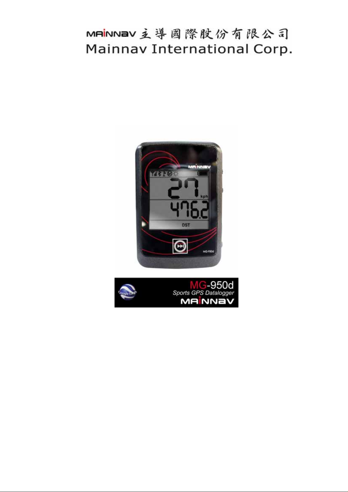
MG-950d 使用手册
MG-950d User Manual
使用者说明书
V1.1

MG-950d 使用手册
A. 快速使用指南…………………………………………………………….
B. 产品概述 …………………………………………………………………
C. 特色……………………………………………………………………………
D. 规格 ………………………………………………………………………
外观尺寸 ………………………………………………………………………
操作环境 ………………………………………………………………………
GPS ………………………………………………………………………………
定位精度 ………………………………………………………………………
蓝芽 ……………………………………………………………………………
界面….…………………………………………………………………………
电源转接头………………………………………………………………………
电池………………………………………………………………………………
MG-950D 配件与相关认证……………………………………………………………
保固………………
E. 使用特性
F. 认证
………………………
……………………
………………………………………………………………
………………………………………………
……………………………………………………
2
4
4
5
5
5
5
5
6
6
6
6
6
6
7
8
G. 软件输出接口
H. 大地坐标输出与设定
I. 脚踏车支架安装方式 ………………………………………………………
……………………
……………………
……………………………………………
…………………………………
8
9
12
1
1.硬件外观介绍
MG-950d 使用手册
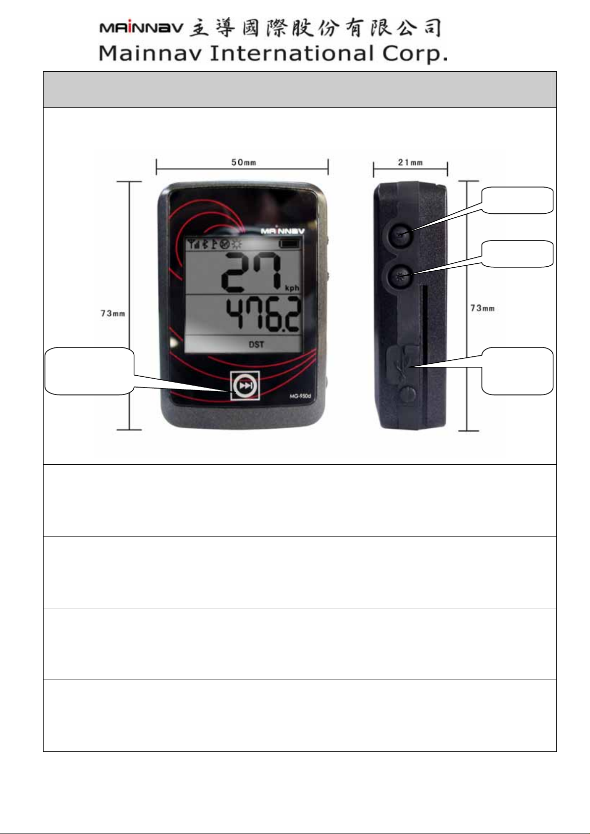
A.快速使用指南
电源开关
背光开关
功能切换触
摸区
1.
标准包装
MG-950d BT GPS Data logger 本体 + 车用充电器 +可充放式锂离子电池+旅行充电器+产品光盘
+保证书+快速使用指南 + 充电与数据传输线
USB 连接
埠
2.使用前请先将电池持续充满
第一次使用时,请将电池充电至饱和,在充满电的情形下可以持续使用12小时(未开启背光模式下),
在已定位后即进入省电模式。
3.
将你的 PC 或 PDA 上面的蓝芽功能打开
启动 MG-950d 之后,将你所持有的设备平台上所配备的蓝芽功能打开,如果您的设备上面没有蓝
芽功能,你必需加装任何可连接蓝芽设备的适配器。
4. 在蓝芽管理器上面发现蓝芽设置
点击在设备上蓝芽管理器上面发现的”Mainnav-GPS”标示,设备会自动的连结上所点选
的”Mainnav-GPS 蓝芽接收机,MG-950d 蓝芽配对的密码为”0000”。
2
MG-950d 使用手册
5. 在导航地图上选择正确的 Com port
开启你的地图并且选择地图上正确与蓝芽连接的 comport,进行导航工作。
6. 关闭你的蓝芽装置
在关闭你的 PC 或 PDA 之前,请先将蓝芽装置关闭及退出与 MG-950d 的连接。
7.LCD 显示说明
显示海拔高度 显示当前时间 显示总里程数 显示移动时间
显示移动距离 显示平均时速 显示最高时速 数据归零(时间除外)
7-1.功能符号与按键操作显示说明
操作方式 显示符号 定义
电源开关短按 3秒
开机后 45 秒内
开机后长按电源键 3 秒
开启轨迹记录后长按电源键 3 秒
将手持设备蓝芽联机至本机
内存记录状态
短按背光按键 1 秒
长按背光按键 5 秒
长按背光键 12 秒
双按电源键与背光键 3 秒
开机状态(GPS、蓝牙已启动)
GPS 已定位
轨迹纪录启动
关闭轨迹记录
蓝芽已联机(接收机功能启动)
内存已满(需使用 PC 下载内存内记
录数据并且清除)
背光开启
数据归零(屏幕所有显示信息)
总里程数归零(ODO)
英制(mph)/公制(kph)选择
3

MG-950d 使用手册
电池符号闪烁
关机状态下双按电源键与背光键
短按切换页按键
长按 3 秒切换页键
电力不足 1 小时(未开启背光下)
调整时区 power 为调整键,背光键
为设定完成
切换显示数据(如 7.LCD 显示说明)
实时数据自动播放(如 7.LCD 显示说
明自动切换显示)
8.轨迹记录器
当您打开 MG-950d 电源之后 GPS 开始接收卫星讯号,长按电源键 2 秒后启动轨迹纪录装置即
可开始记忆你要记录的旅程,你也可以同时使用蓝芽装置配对至具有蓝芽装置的智能型手机或
PDA 等等的平台进行导航作业(与蓝芽接收机功能相同),本体正面下方的触摸按键只要轻轻触摸
即可切换不同的各种实时信息,当您在骑乘自行车同时也可以设定实时信息自动切换页功能,让
您不会因为检视其它功能按单手操作及驾驶,增加骑乘时的危险性,若您不要使用轨迹记录的功
能时,再长按电源键 2 秒即可关闭此功能。(蓝芽接收机功能不会关闭,按键显示功能与按键定义请
参阅 7-1 功能符号显示说明),若您要检视读取你所要记录的轨迹档案时,将数据线插入本机中的
Mini USB 的插口,或是使用蓝芽无线传输连接到计算机(必须安装本公司产品光盘中的应用软件)即
可将您所记录的数据读取并导入”Google Earth®”中。软件操作说明请详见光盘中”Mainnav GPS
Application Software”说明
B.产品概述
MG-950d 是一个全功能的蓝芽卫星接收机具备 GPS 轨迹记录功能的一体机,GPS 的部份是以
SiRF Star III 的单芯片做为设计基础,它提供了目前世界上民用导航所需求的最高灵敏度的性能,
应用在车用导航、测绘、保全、农业上有着卓越的操作特性。它的高感度性能可以在任何恶劣的
环境下进行定位的作业,在定位之后能同时接收 20 颗卫星并显示 12 颗以上的定位信息,智能型
的记忆储存方式,在移动状态下,每秒记录 1 点,在未移动状态下,每分钟记录 1 点,大幅提升
了内存储存效率,避免在停止时的产生的无效记录。MG-950d 的蓝芽有效的传输距离为 10 米,
让无线的应用更贴近生活上的需求,独家的”Trickle Power”省电模式在定位后让耗电量大幅降低让
使用的时间更长久,MG-950d 所具备的轨迹记录功能可以将您所到之处完整保存下来,在随机附赠
的应用软件中,可以清晰的检视你所经过的路径,并将您在旅程中所有拍摄下珍贵的照片整合在
您所记录的地理信息中,可记录 130,000 笔的超大容量记忆航点能满足您任何的记录需求,在 LCD
显示屏上所显示呈现的 GPS 实时信息,提供了使用者在户外活动,驾车旅游、单车运动等最可靠的
讯息,不论何时、何地当你开启 MG-950d 的轨迹记录功能,让您掌握并记录珍贵的活动记录。在
MG-950d 上所标配的软件进行照片与路径的整合,并做完整的分析。”凡走过必留下足迹 ”在
MG-950d 的强大功能下,让它成为你生活中的最佳伴侣并且把珍贵的足迹开始珍藏下来吧。
4

MG-950d 使用手册
C.特色
1. 定位模式: 20 海平面以上 20 颗有效卫星并显示 12 颗有效卫星
2. 核心技术: SiRF Star III SOC(单芯片设计)
3. 内置 WAAS/EGNOS 同步卫星偏差修正信号接收(选项)
4. 在低卫星讯号的情形下也能快速的定位。
5. 内置可充放式锂离子电池(与 NOKIA BL-5C 规格兼容)。
6. 支持 NMEA 0183V2.2 版本
7. LCD 液晶显示 GPS 实时信息
8. 高感度 -159 dBm
9. 130,000 笔 GPS 轨迹记录航点存储。
10.智能记录模式,在移动状态下,每秒记录一点;静止状态下,每分钟记录一点。
11.内建 16Mb 内存
12.与蓝芽手机或 PDA 配对可传输 GPS 讯号提供导航功能使用(蓝芽接收机模式)
13.USB2.0 及 Bluetooth 蓝芽 2.0 双传输模式装置
14.电容式感应触摸功能键
15.友善软件应用接口(照片整合功能)
16.专为自行车或摩托车使用模式设计的支撑托架
17.耐候级防水设计 IP X6
D.规格
外观尺寸:
尺寸: Size: 73(L) x 50(W) x 21(H) (mm)
重量:70 公克
操作环境:
1. 操作温度:-20℃~+85℃
2. 储存温度:-55℃~+75℃
3. 输入电压: 5.5 ± 0.5VDC
GPS:
1) 卫星捕捉数量: 海平面以上 20 颗
2) 锁定卫星:12 颗以上并显示
3) 更新速率: 1 秒
4) Acquisition time
定位数据更新:1 sec, averaged
瞬间定位速度:0.1 sec, averaged
5

MG-950d 使用手册
热开机: 4 sec, averaged
暖开机: 38 sec, averaged
冷开机: 42 sec, averaged
定位精度:圆周<10 米(CEP)
耗电量与使用效能
MG-950d 的耗电量为 55 mA/h(未使用背光)
GPS 在捕捉卫星定位后,可以持续使用 12 个小时。
MG-950d 在背光模式下,可以持续使用 10 小时。
定位精度:
1. 无偏差修正下:Non DGPS (Differential GPS)
定位精度::<10 米
速度 :0.1 米/秒
时间:1 微秒 (卫星时间)
2. 在偏差修正下(选项):
位置点: 1 ~ 5 米
速度: 0.05 米/秒
3. 动态规格::
高度: 18,000 米 (60,000 英尺)
速率: 515 米/秒 (1000 knots)
爆冲: 20 米/秒
加速度: 4 G
传输方式:
蓝芽
1) 传输距离:10 米
2) 蓝芽版本:V2.0版
3) 蓝芽进接装置: Serial Port Profile(SPP)
USB 2.0
界面:
1) USB 2.0, Bluetooth V2.0 ,传输数率4800 ~ 38400
2) NMEA 0183 Version 2.2 ASCII output (GPGGA, GPGLL, GPGSA, GPGSV, GPRMC, GPVTG).
3) Real-time Differential Correction input (RTCM SC-104 message types 1, 5 and 9).偏差信号接
收(选项)
4) SiRF 通讯协议 (选项)
6

MG-950d 使用手册
内存:
16Mb SPI 可擦写序列式闪存
电源接头规格:
USB Mini Din 5 PIN
电池:
容量: 850mAh.(与 Nokia BL-5C 电池相容)
形式: 可重复充放锂离子电池(Li-ion)
MG-950d所属配件:
1.可重复充放锂离子电池:Rechargeable battery 850mAh
2.车用充电器:600mA/h Cigarette Adapter, USB Mini DIN 5 PIN
3.自行车或摩托车专用机体固定支架
4.软件光盘
5..传输/充电二用数据线
6.旅行用充电器(选项)
7.简易操作说明
8.产品保证卡
相关认证:
RoHs
CE&FCC
BQB
保固:本产品(MG-950d)保固期限为一年,但人为因素或其它不可抗力之损坏不在此列保固范
围之内。
7

MG-950d 使用手册
E. Operational characteristics (使用特性)
Initialization
Once the initial self-test is complete, MG-950d start the process of satellite acquisition and
tracking automatically. MG-950d takes about 45 seconds to achieve a position fix in normal
circumstances. After a position fix has been calculated, valid position, velocity and time is
transmitted over the output channel.
Also, our MG-950d records NMEA position data from a GPS. It is really convenient, economical
alternative to using a laptop computer or PDA, especially on long road. Simply connect the
logger to a GPS during your trip then download the track data to a PC.
Data logger
1. LCD screen which shows speed altitude/latitude
2. Reads NMEA data from GPS
3. Compact size and lightweight
4. Store up to 130,000 waypoints
5. User friendly Windows based Mainnav software
6. Whether proof IPX6
7. With user friendly Windows based Google earth software
8. Replay the recorded routes/ time/ speed... point by point
Navigation
With the acquisition process is completed, the MG-950d sends valid navigation information
over output channels. The data include:
1) Velocity
2) Error estimates
3) Date/time
4) Latitude/longitude/altitude
5) Satellite and receiver status
8

MG-950d 使用手册
F. Safety Statement (认证)
R&TTE / CE
This device complies with ETSI EN 300 328-1, ETSI EN 301 489-1 / 17, EN60950.
BQB
In SIG listing.
FCC
This device complies with Part 15C, Part 15B and ID Application of the FCC rules. Operation is
subject to the following two conditions:
This device may not cause harmful interference.
This device must accept any interference received, including interference that may cause
undesired operation.
G. Software Interface(输出软件接口)
NMEA Transmitted Messages Outpu Messages NMEA Sen ence t t
GPGGA: Global positioning system fixed data
GPGLL: Geographic position latitude \ longitude
GPGSA: GNSS DOP and active satellites
GPGSV: GNSS satellites in view.
GPRMC: Recommended minimum specific GNSS data
GPVTG: Course over ground and ground speed
Global Positioning System Fix Data
$GPGGA,161229.487,3723.2475,N,12158.3416,W,1,07,1.0,9.0,M, ,0000*18
Name
Message ID
UTC Time
Latitude 3723.2475
Example
$GPGGA
161229.487 Hhmmss.sss
Units
ddmm.mmmm
GGA protocol header
Description
N/S Indicator N N=north or S=south
Longitude 12158.3416 dddmm.mmmm
E/W Indicator W E=east or W=west
Position Fix
Indicator
1 See Table 5-3
9

MG-950d 使用手册
Satellites Used 07 Range 0 to 12
HDOP 1.0
Horizontal Dilution of
Precision
MSL Altitude 9.0 Meters
Units M Meters
Geoid Separation Meters
Units M Meters
Age of Diff. Corr. second
Diff. Ref. Station ID
0000
Null fields when DGPS is
not used
Checksum *18
<CR> <LF>
End of message
termination
H. 输出设定
NMEA Transmitted Messages Outpu Messages NMEA Sen ence
t t
GPGGA: Global positioning system fixed data
GPGLL: Geographic position latitude \ longitude
GPGSA: GNSS DOP and active satellites
GPGSV: GNSS satellites in view.
GPRMC: Recommended minimum specific GNSS data
GPVTG: Course over ground and ground speed
Global Positioning System Fix Data
$GPGGA,161229.487,3723.2475,N,12158.3416,W,1,07,1.0,9.0,M, , ,0000*18
Name Example Unit Description
Message ID
UTC Time
$GPGGA
161229.487 Hhmmss.sss
Latitude 3723.2475
N/S Indicator N N=north or S=south
Longitude 12158.3416 dddmm.mmmm
E/W Indicator W E=east or W=west
ddmm.mmmm
GGA protocol header
Position Fix Indicator
1 See Table 5-3
Satellites Used 07 Range 0 to 12
HDOP 1.0 Horizontal Dilution of Precision
MSL Altitude 9.0 Meters
10

MG-950d 使用手册
Units M Meters
Geoid Separation Meters
Units M Meters
Age of Diff. Corr. second Null fields when DGPS is not used
Diff. Ref. Station ID
0000
Checksum *18
<CR> <LF> End of message termination
Position Fix Indicator
Value Description
0 Fix not available or invalid
1 GPS SPS Mode, fix valid
2 Differential GPS,SPS mode, Fix valid
3 GPS PPS Mode, Fix valid
GNSS Satellites in View
(GSV)$GPGSV,2,1,07,07,79,048,42,02,51,062,43,26,36,256,42,27,27,138,42*71
$GPGSV,2,2,07,09,23,313,42,04,19,159,41,15,12,041,42*41
Name Example Unit Description
Message ID $GPGSV GSV protocol header
Number of Messages 2 Range 1 to 3
Message Number 1 Range 1 to 3
Satellites in View 07 Range 1 to 12
Satellite ID 07 Channel 1 (Range 1 to 32)
Elevation 79 degrees Channel 1 (Maximum 90)
Azimuth 048 degrees Channel 1 (True, Range 0 to 359)
SNR (C/No) 42 dBHz Range 0 to 99, null when not tracking
Satellite ID 27 Channel 4 (Range 1 to 32)
Elevation 27 degrees Channel 4 (Maximum 90)
Azimuth 138 degrees Channel 4 (True, Range 0 to 359)
SNR (C/No) 42 dBHz Range 0 to 99, null when not tracking
Checksum *71
<CR> <LF> End of message termination
11

MG-950d 使用手册
Name Example Unit Description
Message ID $GPRMC RMC protocol header
UTC Time
Status A
Latitude 3723.2475 ddmm.mmmm
N/S Indicator N N=north or S=south
Longitude 12158.3416 dddmm.mmmm
E/W Indicator W E=east or W=west
Speed Over Ground 0.13 Knots
Course Over Ground 309.62 Degrees True
Date 120598 ddmmyy
Magnetic Variation (1) Degrees E=east or W=west
Checksum *10
<CR> <LF> End of message termination
Recommended Minimum Specific GNSS Data (RMC)
$GPRMC, 161229.487,A,3723.2475,N,12158.3416,W,0.13,309.62,120598, ,*10
161229.487
hhmmss.sss
A=data valid or V=data not
valid
12

MG-950d 使用手册
I. 自行车支架安装方式
步骤 1.选取安装位置 步骤 6.将束线带穿入固定孔
步骤 2.将本体固定座与车把固定做结合 步骤 7.完成束线带穿孔
步骤 3.将螺丝锁紧固定 步骤 8.固定至车把位置
步骤 4.固定橡皮座(1) 步骤 9.将束线带绕过车把
步骤 5.固定橡皮座(2) 步骤 10.将 2 条束线带束紧
13

步骤 11.将束线带剪断
步骤 12.将本体导入滑槽固定
步骤 13.完成安装
MG-950d 使用手册
14
 Loading...