

LEI Extras ST, FISHEASY ST, MAPCREATE USA 6.3 TOPO - ADDENDUM, MapCreate USA 6.3 Topo Addendum
Page 1

1
Pub. 988-0154-201
Addendum I For
MapCreate USA 6.3 Topo
Thank you for buying the USA topo version of MapCreate. This addendum describes features and functions that differ from the basic version
of MapCreate.
MapCreate Topo is ideal for aviation, backpacking and related outdoor
activities, but it was specially designed for hunters. Maps made with
MapCreate Topo will work in other Lowrance
GPS units, but this pro-
gram was developed to complement the iFINDER
HUNT hand-held
GPS receiver. MapCreate Topo is the first GPS mapping software to
offer such extensive boundary data for several types of public hunting
lands, game management units and related areas.
NOTE:
MapCreate Topo and its companion iFINDER HUNT GPS were introduced in the summer of 2004, but their development is continuing. More free features and enhancements are planned for release
as the fall hunting season approaches. We strongly recommend
you check the Lowrance web site, www.lowrance.com, for free
downloads of updated software and instruction manuals.
The high detail map data provided with this program is organized into
six regions. To install MapCreate, follow the instructions in the manual
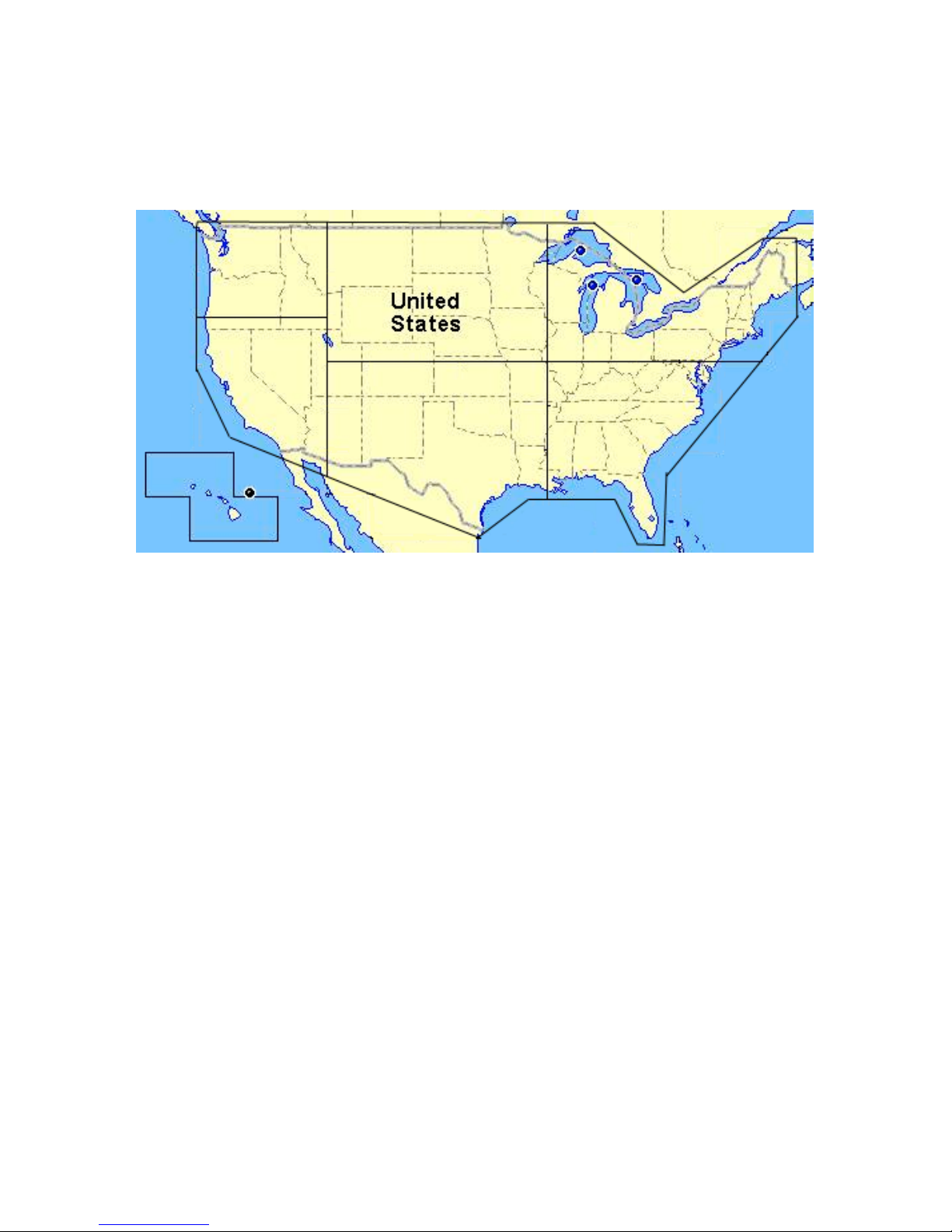
but refer to the map on page 3 of this addendum to find out which region is recorded on which CD.
Material covered in this addendum includes:
New Mapping Data
• Topographic elevations, public hunting areas and game management
units are discussed along with other new data on page 3. Be sure to
read the map data disclaimer following the data descriptions.
Additional Symbols
• New hunting-specific symbols make it easier to scout ahead of the
hunt and mark important spots. Described on page 4.
Searching
• MapCreate Topo lets you search for POIs, land features and more,
just as you can in a Lowrance GPS unit. The details are on page 5.
Aviation Searching
• Load a card containing a Jeppesen Aviation Database into the card
Page 2

2
reader and MapCreate Topo lets you search for items such as airports
and VORs. On page 6.
Find Nearest Waypoint or Nearest Highway Exit
• It's easier to find these items with the new right-click shortcut. See
page 6.
Map Category Options Toolbar
• A drop-down menu lets you select pre-set or customizable category
settings for activities ranging from hunting to aviation. On page 7.
Routing
• MapCreate Topo lets you accurately add POIs, land features and avia-
tion navaids to routes with a click of the mouse. Read more about it on
page 7.
Dynamic Pan Arrows
• The permanent pan arrows that were located along the sides of the
Master Map window have been replaced with pop-up pan arrows.
You can even pan diagonally! See page 7.
Pop-up Boxes
• Pop-up information boxes for POIs, land features and interstate
highway exits now include elevations. Exit pop-up boxes also list
nearby exit services. See page 8.
Color Legend
• A legend describing the colors of different areas is at the end of this
document. This printed document is in black and white, but the
version in the Help File is in color. See page 8.
Map Coverage by CD
The program's map data is provided on six CDs. The installation disc is
CD 1. If you choose to use Full Install, all of the high detail map data
will be available from your hard drive. This requires 3.3 GB of space.
A Custom Install lets you select only the region(s) you want to be installed on the hard drive. If you want to view high-detail maps in a region you did not install, you must place that regional CD in the disc
drive to see maximum detail.
The Compact Install loads your hard drive with the basic program,
along with navigational aid data and a medium-detail world map. This
requires approximately 300 MB of space. If you want to view highdetail maps, you must place the desired regional CD in the disc drive to
see maximum detail.
Page 3
3
In this package, northwest United States and Alaska are on CD 1;
southwest U.S. and Hawaii are on CD 2; north central U.S. is on CD 3;
south central U.S. is on CD 4; northeast U.S. is on CD 5 and southeast
U.S. is on CD 6. To view the high-detail data boundaries, see the following figure.
Continental United States and Hawaii showing approximately where
data is divided on the six CDs.
New Mapping Data Types:
Elevation Contour Lines
MapCreate Topo includes topographic elevations for 49 states (excluding Alaska). These are shown as major and minor contour lines, with
numbers showing the elevation above sea level. Contour lines begin to
appear at about the 56 mile zoom range (depending on your monitor
size and resolution). At that zoom level and closer, the mouse pointer
also triggers a pop-up box showing elevation at that point. Read more
about pop-up boxes on page 8.
Hunting
Public Hunting Area boundaries and their names from 47 states are
included. Alaska, Hawaii and Washington state are not included.
Game Management Unit boundaries for 22 states are included, in the
following categories: antelope, bear, deer, elk goat, moose, mule deer,
sheep, turkey (spring and fall) and whitetail deer.
The GMU states include: Arizona, Colorado, Iowa, Idaho, Kansas, Kentucky, Massachusetts, Minnesota, Missouri, Montana, North Dakota,
Nebraska, New Mexico, Nevada, New York, Ohio, Oregon, Pennsylvania, South Dakota, Utah, Wisconsin and Wyoming.
CD 1
(Northwest)
plus Alaska
CD 3
(North Central)
CD 2
(Southwest)
CD 5
(Northeast)
CD 6
(Southeast)
CD 4
(South Central)
CD 2
Page 4

4
State and federal wildlife refuge and wilderness area boundaries are
also included.
Other Data Types
There are other areas that are open to hunting in some states or are
otherwise important to hunters, and we have included them. These are
boundaries for state parks, state forests and military reservations. (National forests and national parks were already included in the MapCreate 6.3 non-topo version.)
Hikers and backpackers as well as hunters will appreciate the addition
of intermittent streams. They are just part of the overall improved hydrography data which has better resolution and pop-up names. U.S.
coastline and lakeshore detail has been dramatically improved. MapCreate Topo also now includes USGS 1:24000 scale quadrangle map
boundaries and their names, which are searchable. This makes it easier to determine what USGS topo maps you may want to purchase for
your outdoor adventures. Sections, township and range lines are included. Boundaries have also been added for cities over 2,500 population.
Important Notice
Do not rely on this product as your primary source of information for navigation or area boundaries. You are responsible for
using official government maps and charts during your outdoor
activities. Due to the varied ownership and fluctuating borders
of publicly managed hunting lands and game management units,
you should also consult boundary signs and other on-site identifiers when using those areas.
Activities on public hunting lands are carefully managed to ensure the future of game and non-game species. You must consult
local wildlife agency regulations for the hunting areas you use.
The Lowrance web site,
www.lowrance.com, contains links to
the web sites of all state and Canadian provincial wildlife agencies to help access both hunting regulations and official mapping information. Also, updates to MapCreate's mapping data
are ongoing; MapCreate Hunting Topo customers may download
regional updates of hunting-related data categories from the
Lowrance web site.
LEI makes no warranties, express or implied, regarding the
maps and information contained in this product, including any
implied warranties of merchantability, satisfactory quality, fitness for a particular purpose or non-infringement of third party
rights. A full description of our warranty is available in the End
User License Agreement in the MapCreate manual.
Hunting Specific Symbols
MapCreate has a basic set of 42 symbols used to represent waypoints
Page 5

5
or event marker icons. That set contains several hunting symbols –
such as deer track and tree stand – but we have added more than a
dozen new ones. Now you can use a specific symbol to mark items
ranging from turkeys to ATVs and from food plots to buck rubs
Searching
One of the most powerful new functions in MapCreate Topo is the ability to search for POIs and several types of land features. To launch the
command, click the
FIND button on the Map Navigation toolbar (it looks
like a binocular). The Find Menu appears, with a dialog box for the
item's name, and pull down menus for the major category and minor
category to search in.
For nearest searches, MapCreate begins looking from the current center of the map. When you select an item from the search results, that
item will be snapped to the center of the map. When you search for a
river, the map will be centered at the mouth of the river.
You can insert an IMS Fishing Hot Spots
map card in the card
reader and you can search for several categories of Fishing Hot Spot
items. However, you must first locate the desired lake and center it in
the map before searching for specific fishing items.
When searching for any map item, you often must know the item's "official" name to locate it (especially the first part of the name). Here's an
example search, showing the importance of knowing an official name:
We'll look for Truman Lake, which is located in Henry County, Missouri. All the locals and regular out-of-state visitors know this manmade water body as Truman Lake, but that's not the official name
1. Click the
FIND toolbar button.
2. In the Name box, enter Truman Lake.
3. In the Major Category menu, select Water.
4. In the Minor Category menu, select Lake/River Names, to narrow
the search, then click the
FIND button on the menu.
MapCreate displays a list of items, but Truman Lake isn't there! That's
because the full name is Harry S Truman Reservoir. Instead of
"Truman Lake," just try "Harry," "Harry S" or "Harry S Truman," but
don't use "Harry Truman" without the "S" or you'll miss it.
A search for "Harry S Truman" produces a list of possible answers in
the middle list window. Scroll through the list and select Harry S
Truman Reservoir (2). Next, in the bottom list window, click on a loca-
Page 6

6
tion to show it on the map, then click
OK to clear the Find menu. Now
simply zoom in until you see the item you were searching for.
When searching for a section of land, it helps to know the legal description of the land you are looking for. Land descriptions are read from left
to right, and you must enter your search in the same order. For example, to look for the section containing this property: N 1/2 SE 1/4 SW
1/4, S24, T32N, R18E in Wisconsin, in the Name box you would enter
s24,t32n,r18e, which stands for Section 24, Township 32 North, Range
18 East. Note that capital letters are not needed, and the entries are
separated by commas with no spaces.
Aviation Searching
With your Jeppesen aviation database you can search for airports, intersections, NDBs and VORs. You can search for intersections only by
Identifier. You can search for the other items by Name, Identifier or
City.
To find the Bartlesville, Oklahoma, VOR by City,
1. Insert the card containing your Jeppesen database in the card
reader, and wait for MapCreate to read the card.
2. Click the
FIND toolbar button.
3. In the Name box, enter Bartlesville.
4. In the Major Category menu, select Aviation.
5. In the Minor Category menu, select VORs.
6. In the Search Options box, click
BY CITY then click the FIND button on
the menu.
7. Only one "Bartlesville" appears in the results list windows. In the
bottom list window, click on Bartlesville, then click
OK to clear the Find
menu. Now simply zoom in until you see the item you were looking for.
Find Nearest Waypoint, Highway Exit
Right click on the map and a pop-up menu gives you the option to FIND
NEAREST WAYPOINT or FIND NEAREST INTERSTATE HIGHWAY EXIT. Click the desired
command and MapCreate will search for the item nearest to where you
clicked the map. The found item will snap to the center of the map. The
command will find the nearest waypoint even if it hasn't been saved yet
in a GPS data file.
Page 7

7
Map Category Options Toolbar
MapCreate Topo contains a Map Category Options toolbar. The toolbar
includes a
VIEW MAP CATEGORY OPTIONS button which opens or closes the
Map Category Options Widow with one click.
There is a
MAP USE drop down list that lets you select from several pre-
organized map category displays for Aviation, Boating, Driving, Hiking
and the default, Hunting. Each display can be customized by turning
different categories off and on and there are even two sets called Customize 1 and 2. No matter how much you adjust the displays, you can
return all of them to their defaults by clicking the new
RESET CATEGORY
DISPLAY SETTINGS button.
We identify various land types with different colors, and you may want
to temporarily turn some categories off for better viewing of some details. For example, in military reservations, the dark blue color nicely
identifies the area boundaries, but blue roads don't stand out as they
normally do. Before you build a custom the map, just remember to turn
the map category back on if you want it included in the custom map.
Routing
MapCreate Topo makes it easier than ever to plan an aviation or other
route based on navaids, POIs or land features.
Click the
CREATE ROUTE button (described fully in the manual) to acti-
vate the command. Then, simply click on the desired navaids in order
to make your route. Previous versions created an ordinary numbered
waypoint where you clicked, which often covered up the item you were
routing to. Now, when you click on a named item, a small red route dot
appears on top of the item's symbol, and the item's actual name and
position appear in the route waypoint list.
When editing routes made in this manner, you can insert additional
route waypoints from the master map with a right click, but to delete a
point from the route, you must open the route waypoint list and right
click the point there.
Dynamic Pan Arrows
Previously, MapCreate panned the Master Map by clicking on Pan Arrow Buttons that were fixed to the sides of the map window. MapCreate Topo has eliminated those four buttons and replaced them with
white pop-up pan arrows. When you move the mouse pointer near the
edge of the map, the pointer becomes a Pan Arrow. Just click to see
more of the map in the direction indicated. Move the mouse pointer
away from the edge and it reverts to the previous command you had
selected. You can also point to the corners of the map to pan diagonally.
Page 8
8
Pop-up Boxes
Pop-up info boxes for POIs, land features and interstate highway exits
now include more information. To display a pop-up box, move your
mouse pointer over the item at an appropriate zoom range. Depending
on your computer monitor size and resolution, these detailed pop-ups
become available beginning somewhere in the 50 to 30 mile zoom
ranges. If you don't see the desired information, just zoom in a little
closer until it becomes available.
Water pop-ups now show the name of the water body. Interstate highway exit pop-ups show: the exit number, an exit description (usually
the name of the cross street), the mile marker and exit services located
off the highway within approximately one mile from the exit.
Elevations are shown in pop-ups for POIs, land features and interstate
highway exits. Elevation pop-ups can also give you the elevation for
points located between the displayed contour lines. For example, in a
gradually sloping area between an 850 foot contour line and a 900 foot
line, slowly move the mouse pointer between them and you'll see readings such as 887 feet, 871 feet, 869 feet and so on.
Color Legend
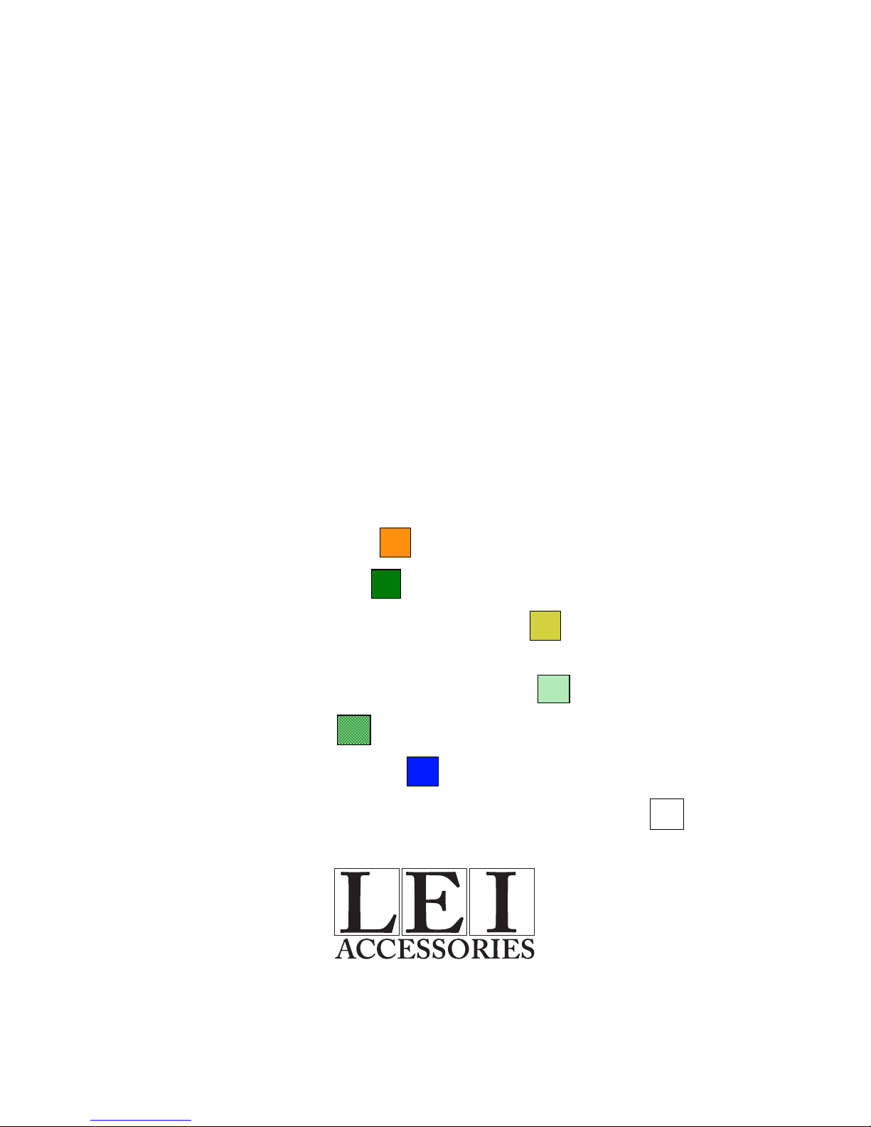
Public hunting areas: orange
Wildlife refuges: dark green
U.S. Army Corps of Engineer land: olive green
National forests; state forests; national, state and local parks; golf
courses and other recreation areas: light green.
Swamps: medium green
Military reservations: dark blue
Other public lands (such as airports and universities): white
For Lowrance and Eagle Products
Pub. 988-0154-201 © Copyright 2004
All Rights Reserved
Printed in USA 072704 LEI
 Loading...