

Kenwood KNAG520 User Manual [nl]
KNA-G520
B64-3432-08
MODE D’EMPLOI
INSTRUCTION MANUAL
ISTRUZIONI PER L’USO
GPS NAVIGATION SYSTEM
MANUAL DE INSTRUCCIONES
MANUAL DE INSTRUÇÕES
GEBRUIKSAANWIJZING
BEDIENUNGSANLEITUNG

WARNING
Read this manual carefully before starting to operate
the Kenwood Car Navigation System and follow
the manual’s instructions. Kenwood is not liable
for problems or accidents resulting from failure to
observe the instructions in this manual.
AVERTISSEMENT
Lisez ce manuel avec attention avant d’actionner
le systeme de navigation Kenwood et suivez les
instructions du manuel. Kenwood decline toute
responsabilite des problemes ou des accidents
provoques par le non-respect des instructions de ce
manuel.
AVVERTENZE
Leggere con cura questo manuale prima di utilizzare
SICHERHEITSHINWEISE
Die Bedienungsanleitung enthält
wichtige Informationen und Hinweise,
die Sie bei Inbetriebnahme des Kenwood
CARNavigationssystems unbedingt beachten sollten.
Lassen sich Unfälle und Brandschäden im Fahrzeug
nicht ausschließen. Zudem erlischt jeglicher Garantieund Haftungsanspruch.
ADVERTENCIA
Lea el manual cuidadosamente antes de poner
en funcionamiento este Sistema de Navegación
Kenwood y siga las instrucciones del manual.
Kenwood no se hace responsable de los problemas o
accidentes derivados de no seguir las instrucciones de
este manual.
AVISO
Leia com muita atenção este manual antes de começar
a utilizar o Sistema de Navegação Kenwood Car
e siga as instruções do manual. A Kenwood não é
responsável por problemas ou acidentes resultantes
da falta de cumprimento das instruções contidas neste
manual.
WAARSCHUWINGEN
Lees deze handleiding aandachtig door alvorens
het Kenwood Navigatiesysteem te gebruiken en
volg de aanwijzingen in de handleiding. Kenwood
kan niet aansprakelijk gesteld worden voor
problemen of ongelukken die te wijten zijn aan
de niet inachtneming van de aanwijzingen in deze
handleiding.
il navigatore Kenwood e seguire le relative istruzioni.
Kenwood non è responsabile per problemi o incidenti
provocati dal mancato rispetto delle istruzioni di
questo manuale.
Garmin® is a registered trademark of Garmin Ltd. or its subsidiaries and may not be used without the express permission of Garmin. • Garmin
ses fi liales qui ne peuvent être utilisées sans l’accord exprès de Garmin. • Garmin
di Garmin. • Garmin® ist eine eingetragene Marke von Garmin Ltd. oder deren Tochtergesellschaften und darf nur mit ausdrücklicher Genehmigung von Garmin verwendet werden. • Garmin
es una marca comercial registrada de Garmin Ltd. o de sus subsidiarias y no se podrá utilizar sin autorización expresa de Garmin. • Garmin
subsidiárias, não podendo ser utilizada sem a autorização expressa da Garmin. • Garmin
gebruikt zonder uitdrukkelijke toestemming van Garmin.
®
è un marchio registrato di Garmin Ltd. o società affi liate e non può essere utilizzato senza consenso scritto
®
is een geregistreerd handelsmerk van Garmin Ltd. of haar dochtermaatschappijen en mag niet worden
®
est une marque déposée de Garmin Ltd. ou de
®
®
é uma marca registada de Garmin Ltd. ou das suas
February 2006 Part Number 190-00493-30 Rev. A Printed in Taiwan

TABLE OF CONTENTS
Warning ...................................................ii
Caution ...................................................iii
Software License Agreement .................iv
Find It and Go! ............................ 1
Finding a Restaurant ............................. 1
Following Your Route .............................
Where To? ................................... 3
Finding an Address ............................... 3
Finding a Place Using the Map .............. 4
Understanding the Information Page ..... 5
Finding Recently Found Places ............ 5
Finding Places in a Different Area .......... 6
Narrowing Your Search ..........................
My Locations .............................. 7
Saving Places You Find ......................... 7
Saving Your Current Location ................
Setting a Home Location ........................ 8
Finding Saved Places ............................ 8
Editing Saved Places ............................. 9
Deleting a Saved Place ........................ 10
The Map and Other Tools ......... 11
Viewing the Map Page ..........................11
Trip Computer ...................................... 12
Turn
List ............................................... 12
GPS Info Page ..................................... 13
Creating and Editing Routes ... 14
2
Creating a New Saved Route .............. 14
Editing a Saved Route ......................... 15
Adding Stops to Your Route ................. 16
Saving the Active Route ....................... 17
Navigating a Saved Route ................... 17
Recalculating the Route ....................... 17
Deleting All Saved Routes ................... 17
6
Stopping Your Route ............................
Adding a Detour to a Route ................. 17
Adding Avoidances .............................. 18
7
Using The Logs ......................... 19
Adjusting the Track Log ....................... 19
Using the Mileage Logs ....................... 19
Traffic Information .................... 20
Viewing Traffic Events .......................... 20
Avoiding Traffic ....................................
Changing the Traffic Settings ............... 22
Adding a Traffic Subscription ............... 23
Changing the Settings ............. 24
Adjusting the Volume ........................... 24
Changing the General Settings ............ 24
Changing the Map Settings .................. 27
Changing the Navigation Settings ........ 29
Adjusting the Traffic Settings ...............
Viewing
Restoring the Settings .......................... 30
Unit Information (About) ......... 30
Appendix ................................... 31
17
Using the Remote Control .................... 31
Updating Software and Map Data ........ 31
Clearing All
Custom POIs (Points of Interest) ......... 32
Kenwood Warranty, UK & Ireland ........
User Data .......................... 31
Index .......................................... 35
English
21
30
33
KNA-G520 Instruction Manual EN-i
Warning
This manual uses the term Warning to indicate a potentially hazardous situation, which, if not avoided, could result in death or serious injury.
English
Failure to avoid the following potentially hazardous situations could
result in an accident or collision resulting in death or serious injury.
When navigating, carefully compare information displayed on the unit to
all available navigation sources, including information from street signs,
visual sightings, and maps. For safety, always resolve any discrepancies or
questions before continuing navigation.
Always operate the vehicle in a safe manner. Do not become distracted
by the unit while driving, and always be fully aware of all driving
conditions. Minimize the amount of time spent viewing the screen of the
unit while driving and use voice prompts when possible.
Do not enter destinations, change settings, or access any functions
requiring prolonged use of the unit’s controls while driving. Pull over in
a safe and legal manner before attempting such operations.
Keep the system’s volume at a low enough level to be able to hear
outside noises while driving. If you can no longer hear outside noises,
you may be unable to react adequately to the traffic situation. This may
cause accidents.
EN-ii KNA-G520 Instruction Manual
This navigation system can be used when the ignition key is turned to
ON or ACC. However, to preserve the battery, it should be used with
the engine running whenever possible. Using the navigation system for
a long time with the engine switched off can cause the battery to run
down.
The navigation system will not display the correct current position of the
vehicle the first time it is used after purchase, or if the battery has been
removed for a long time. GPS satellite signals will soon be received,
however, and the correct position will be displayed.
Be careful of the surrounding temperature. Using the navigation system
at extremely high or low temperatures can lead to malfunction or
damage. Also note that the unit can be damaged by strong vibration or
metal objects or by water getting inside.
PREFACE
English
Caution
This manual uses the term Caution to indicate a potentially hazardous situation, which, if not avoided, may result in minor injury or property damage. It
may also be used without the symbol to alert you to avoid unsafe practices.
Failure to avoid the following potentially hazardous situations may
result in injury or property damage.
The unit is designed to provide you with route suggestions. It does not
reflect road closures or road conditions, traffic congestion, weather
conditions, or other factors that may affect safety or timing while
driving.
Use the unit only as a navigational aid. Do not attempt to use the unit
for any purpose requiring precise measurement of direction, distance,
location, or topography.
The Global Positioning System (GPS) is operated by the United
States government, which is solely responsible for its accuracy and
maintenance. The government’s system is subject to changes which
could affect the accuracy and performance of all GPS equipment,
including the unit. Although the unit is a precision navigation device,
any navigation device can be misused or misinterpreted and, therefore,
become unsafe.
Important Information
MAP DATA INFORMATION: One of the goals of Garmin is to provide customers with the most complete and accurate cartography that is available to
us at a reasonable cost. We use a combination of governmental and private data sources, which we identify in product literature and copyright messages
displayed to the consumer. Virtually all data sources contain inaccurate or incomplete data to some extent. In some countries, complete and accurate map
information is either not available or is prohibitively expensive.
KNA-G520 Instruction Manual EN-iii
PREFACE
Software License Agreement
BY USING THE KNA-G520, YOU AGREE TO BE BOUND BY THE
English
TERMS AND CONDITIONS OF THE FOLLOWING SOFTWARE
LICENSE AGREEMENT. PLEASE READ THIS AGREEMENT
CAREFULLY.
Garmin grants you a limited license to use the software embedded in this
device (the “Software”) in binary executable form in the normal operation
of the product. Title, ownership rights, and intellectual property rights in
and to the Software remain in Garmin.
You acknowledge that the Software is the property of Garmin and
is protected under the United States of America copyright laws and
international copyright treaties. You further acknowledge that the
structure, organization, and code of the Software are valuable trade secrets
of Garmin and that the Software in source code form remains a valuable
trade secret of Garmin. You agree not to decompile, disassemble, modify,
reverse assemble, reverse engineer, or reduce to human readable form the
Software or any part thereof or create any derivative works based on the
Software. You agree not to export or re-export the Software to any country
in violation of the export control laws of the United States of America.
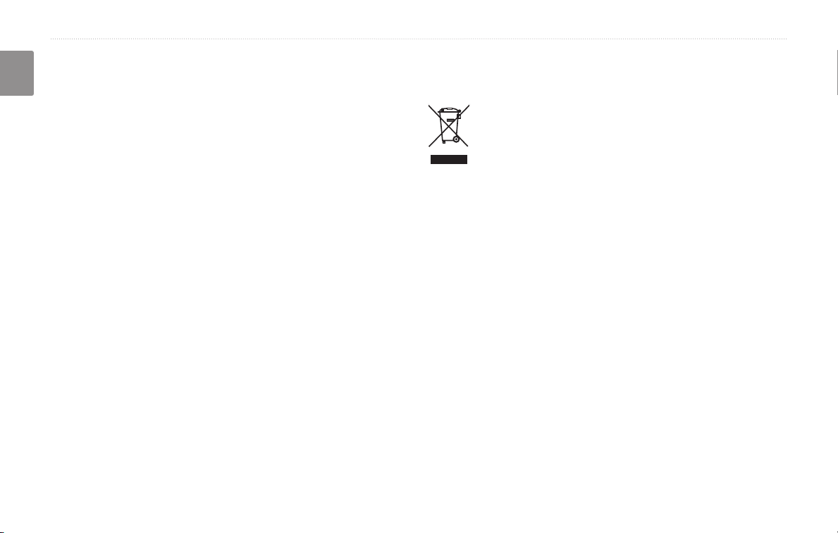
Information on Disposal of Old Electrical and Electronic Equipment
(applicable for EU countries that have adopted separate waste
collection systems)
Products with the symbol (crossed-out wheeled bin) cannot be
disposed as household waste.
Old electrical and electronic equipment should be recycled
at a facility capable of handling these items and their waste
byproducts. Contact your local authority for details in locating
a recycle facility nearest to you. Proper recycling and waste
disposal will help conserve resources whilst preventing
detrimental effects on our health and the environment.
EN-iv KNA-G520 Instruction Manual
FIND IT AND GO!
Follow the instructions on the next two pages to find a place and go to it!
Finding a Restaurant
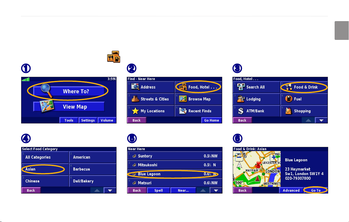
FIND IT AND GO!
English
Touch Where To?
➊
Touch a food category.
➍
KNA-G520 Instruction Manual EN-1
Touch Food, Hotel….
➋
Touch a place.
➎
Touch Food & Drink.
➌
Touch Go To.
➏
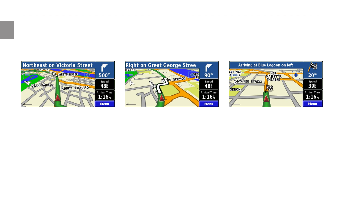
FIND IT AND GO!
Following Your Route
Follow the route to your destination using the map. As you travel, the navigation system guides you to your
English
destination with voice prompts, arrows, and directions along the top of the map. If you depart from the original route,
the navigation system recalculates the route and provides new route instructions.
Your route is marked
with a green line.
Follow the arrows. A checkered flag marks
your destination.
For more information about using the map and the other tools, see pages 11–13.
EN-2 KNA-G520 Instruction Manual
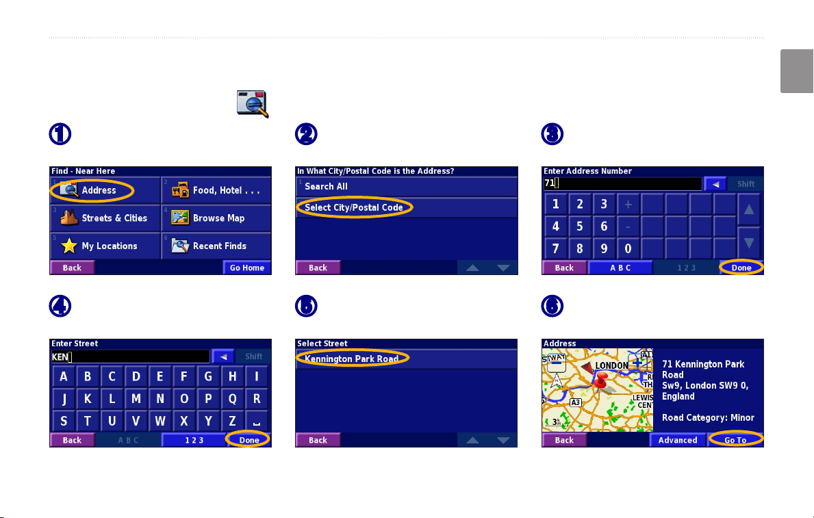
Finding an Address
WHERE TO?
English
WHERE TO?
From the Menu page, touch
➊
Where To? Touch Address.
Enter the street name and
➍
touch Done.
KNA-G520 Instruction Manual EN-3
Select a state. Select a city
➋
or enter a postal code.
Select the street. Select the
➎
city, if necessary.
Enter the address number
➌
and touch Done.
Select the address, if
➏
necessary. Touch Go To.
WHERE TO?
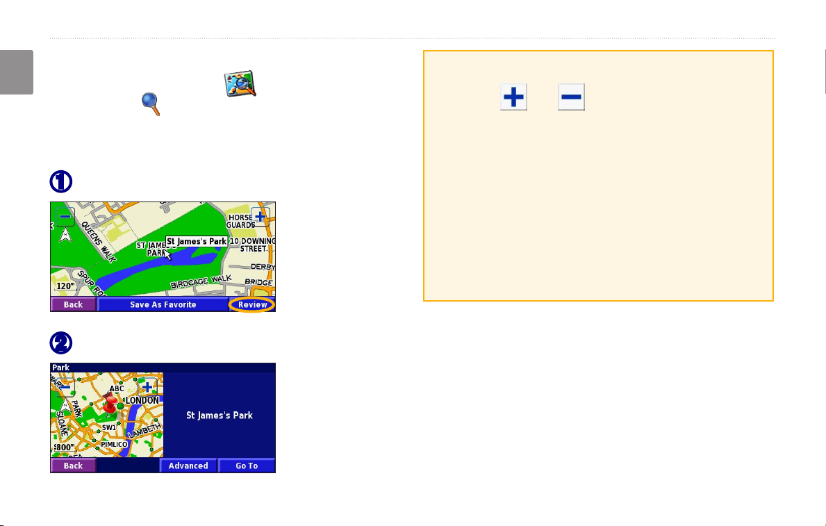
Finding a Place Using the Map
From the Menu page, touch View Map. You
English
can also touch Where to? > Browse Map. Touch
anywhere on the map to recenter the map on that
location.
Touch any object on the map. Touch Review.
➊
Touch Go To or Advanced.
➋
Tips for Browsing the Map
• Use the and icons to zoom in and out.
• Touch an object on the map. The map recenters on
that location, and an arrow appears pointing at the
object you selected.
• Touch
page; for more information, see the next page.
• Touch
selected by the pointer to your Favorites.
• Touch
Review to open the location’s information
Save As Favorite to save the location
Back to return to the previous screen.
EN-4 KNA-G520 Instruction Manual
Understanding the Information Page
When you find a location, select it in the search results
list to open the item’s information page.
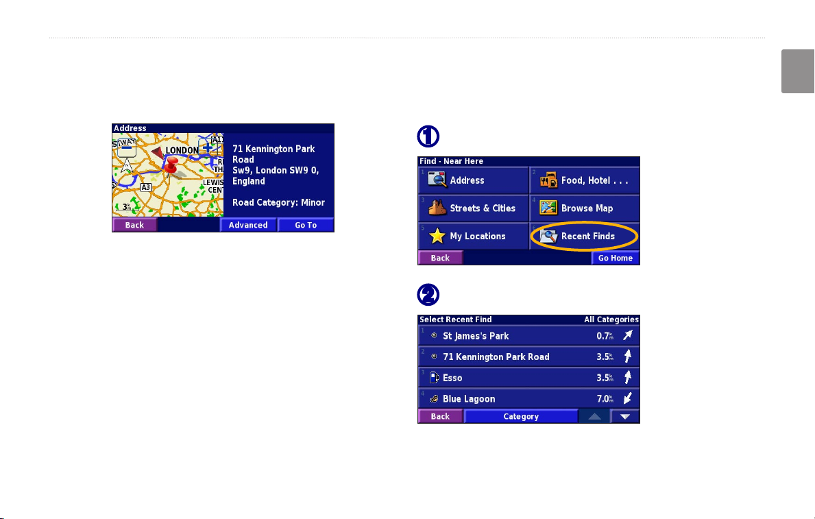
Finding Recently Found Places
The last 50 places you have found are stored in Recent
Finds.
➊
Information Page
Touch Go To to create and follow a route to this location.
➋
Touch Advanced to view other options for this location:
• Insert in Current Route—add this point as the next
stop in your route.
• Add As Favorite—add this location to your
Favorites. For more information, see page 7.
WHERE TO?
English
Touch Where To? > Recent Finds.
Select an item from the search results list.
• Find Near Point—find a location near this point.
• Browse Map—view this location on the map.
KNA-G520 Instruction Manual EN-5
Touch Category to display recent finds from a certain
category, such as Food, Hotel….
WHERE TO?
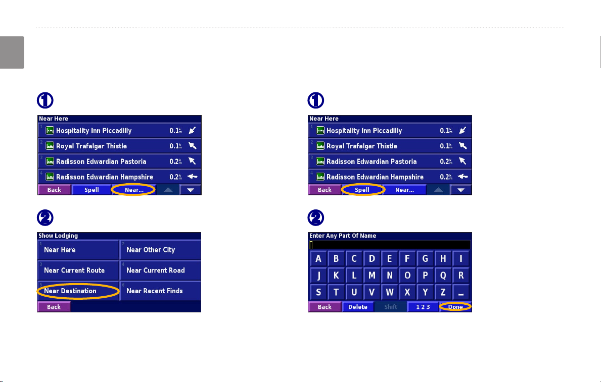
Finding Places in a Different Area
You can search for locations in a different area, such as a
English
different city or near your destination.
From the search results list, touch Near….
➊
Select one of the search options.
➋
Narrowing Your Search
To narrow your search, you can spell part of the name of
the location you are searching for.
From the search results list, touch Spell.
➊
Enter part of the name and touch Done.
➋
EN-6 KNA-G520 Instruction Manual
MY LOCATIONS
MY LOCATIONS
English
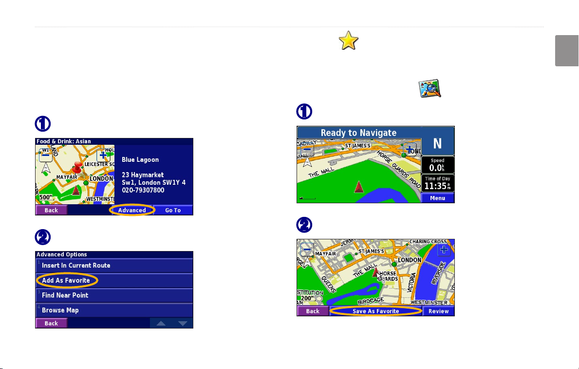
Saving Places You Find
After you have found a place you want to save, select it
in the results list.
Touch Advanced.
➊
Touch Add As Favorite.
➋
KNA-G520 Instruction Manual EN-7
Saving Your Current Location
From the Menu page, touch View Map.
Touch anywhere on the map.
➊
Touch Save As Favorite.
➋
MY LOCATIONS
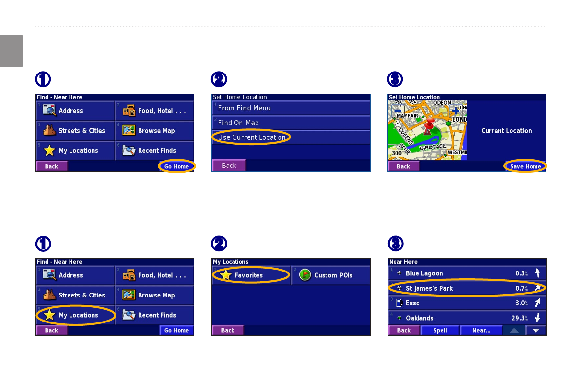
Setting a Home Location
You can set a Home Location for the place you return to most often. From the Menu page, touch Where To?
English
Touch Go Home.
➊
After you set your Home Location, touch Where To? and then touch Go Home.
Select an option.
➋
Touch Save Home.
➌
Finding Saved Places
From the Menu page, touch Where To?
Touch My Locations.
➊
EN-8 KNA-G520 Instruction Manual
Touch Favorites.
➋
Touch a saved place.
➌
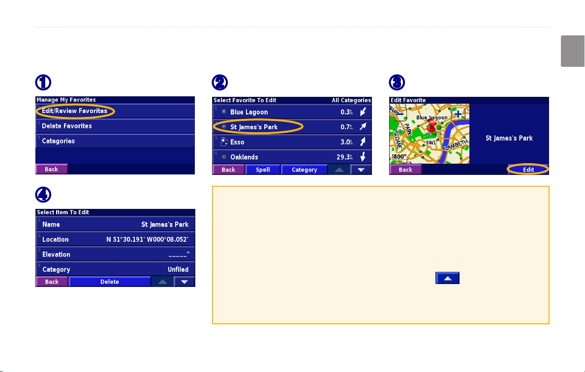
Editing Saved Places
From the Menu page, touch Tools > My Data > Favorites.
MY LOCATIONS
English
Touch Edit/Review Favorites.
➊
Touch the item you want to edit.
➍
KNA-G520 Instruction Manual EN-9
Touch the item you want to edit.
➋
Name—enter a new name for the location using the on-screen keyboard.
Location—edit the location of the place; you can use the map or enter
new coordinates using the keyboard.
Elevation—enter the elevation of the saved place.
Category—assign this place to a category; touch to view the
categories.
Symbol—select a symbol that is shown on the map for this location.
Touch Edit.
➌
MY LOCATIONS
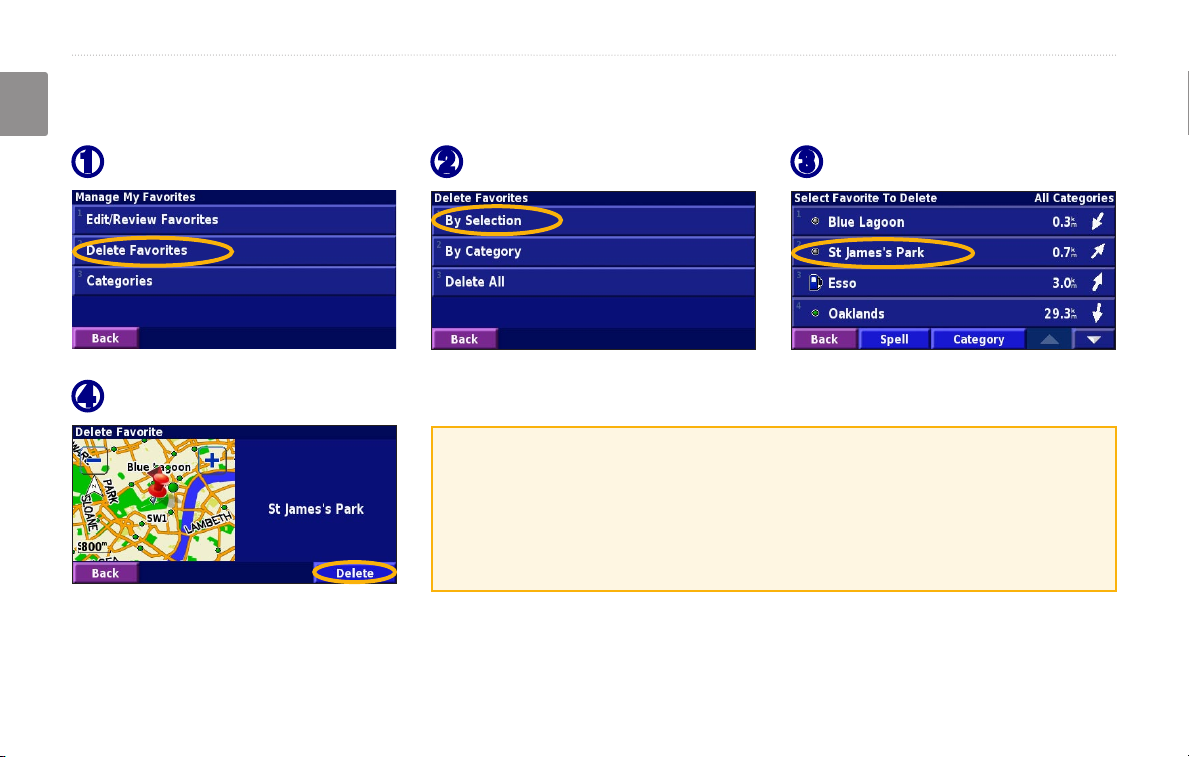
Deleting a Saved Place
From the Menu page, touch Tools > My Data > Favorites.
English
Touch Delete Favorites.
➊
Touch Delete.
➍
EN-10 KNA-G520 Instruction Manual
Touch By Selection.
➋
By Selection—touch each location and delete it individually.
By Category—select one category to delete all of the locations assigned
to that category.
Delete All—removes all saved places from your Favorites.
Touch a saved location.
➌
VIEWING THE MAP AND USING THE TOOLS
English
THE MAP AND OTHER TOOLS
Viewing the Map Page
From the Menu page, touch View Map to open the map. Touch an area of the map to see additional information, as
shown below. The position icon shows your current location.
While navigating a route, touch the green
text bar to open the Turn List. See page 12.
Touch to zoom out.
Touch the map to view and
browse a 2-D map.
Map Page while Navigating a Route
KNA-G520 Instruction Manual EN-11
Touch
Touch the Speed or Arrival
data field to open the Trip
Computer. See page 12.
to zoom in.
VIEWING THE MAP AND USING THE TOOLS
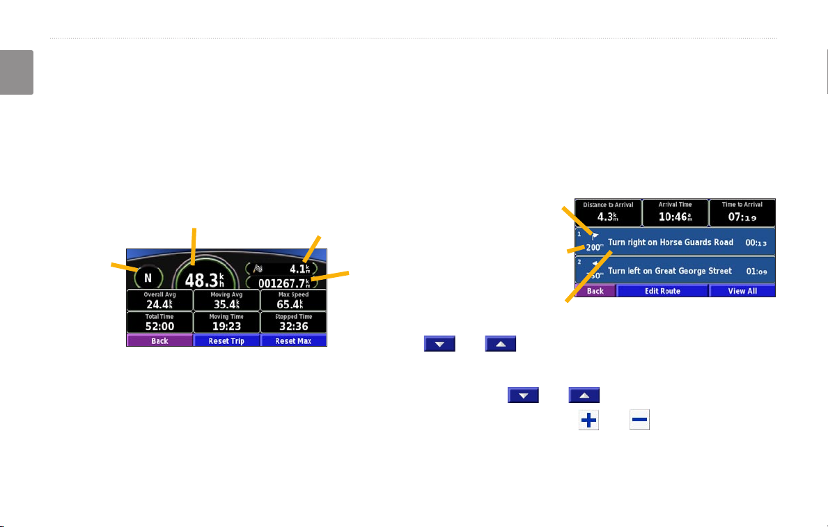
Trip Computer
The Trip Computer indicates your current speed and
English
provides helpful statistics about your trip.
To view the Trip Computer, select Speed or Arrival
on the map. Or, from the Menu page, touch Tools >
Navigation > Trip Computer.
Current speed
Current
direction
of travel
Touch Reset Trip to reset all information on the Trip
Computer. To reset the Maximum Speed, touch Reset
Max.
Distance to your final
destination
Total
distance
traveled
(odometer)
Turn List
The Turn List displays a list of turn-by-turn instructions
for your entire route as well as arrival information.
While navigating a route, touch the green text bar on the
map page to open the Turn List. Or, from the Menu page,
touch Tools > Navigation > Turn List.
Direction of this turn
Distance to this turn
Turn directions
Touch View All to see all the turns in the route. Touch
and to scroll through the list.
Touch a turn to see the turn on a map (the Next Turn
page). Touch
turns in the route. Touch and to zoom in and out
of the turn on the map.
and to scroll through all the
EN-12 KNA-G520 Instruction Manual
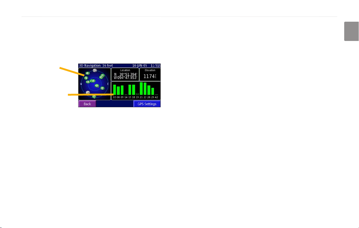
GPS Info Page
From the Menu page, touch the signal strength bars in
the upper left corner to view the GPS Info page. Or, from
the Menu page, touch Tools > Navigation > GPS Info.
GPS Settings
From the Menu page, touch Settings > General > GPS.
You can also access the GPS Settings by touching the
GPS Settings button on the GPS Info page.
VIEWING THE MAP AND USING THE TOOLS
English
Sky view
Use Indoors—touch Yes to turn the GPS receiver off.
Set Position—set your position, if Use Indoors is
enabled. Select your location on the map and touch OK.
Satellite signal
strength bars
WAAS/
EGNOS—disable and enable WAAS/EGNOS.
WAAS and EGNOS are systems of satellites and ground
The sky view shows the satellites you are receiving. The
satellite signal strength bars indicate the strength of each
satellite you are receiving. A solid bar indicates the GPS
satellite is ready for use.
KNA-G520 Instruction Manual EN-13
stations that provide GPS signal corrections, giving you
even better position accuracy. To learn about WAAS and
EGNOS, visit http://www.garmin.com/aboutGPS/waas
.html.
CREATING AND EDITING ROUTES
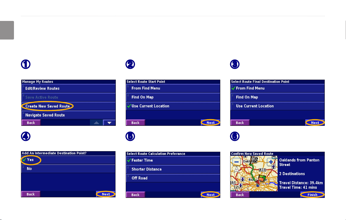
CREATING AND EDITING ROUTES
English
Creating a New Saved Route
From the Menu page, touch Tools > My Data > Routes.
Touch Create New
➊
Saved Route.
To add a stop, touch Yes, then
➍
touch Next. Select the point.
EN-14 KNA-G520 Instruction Manual
Select an option and touch
➋
Next. Select the starting point.
Select your preference
➎
and touch Next.
Select an option and touch
➌
Next. Select the ending point.
Touch Finish.
➏
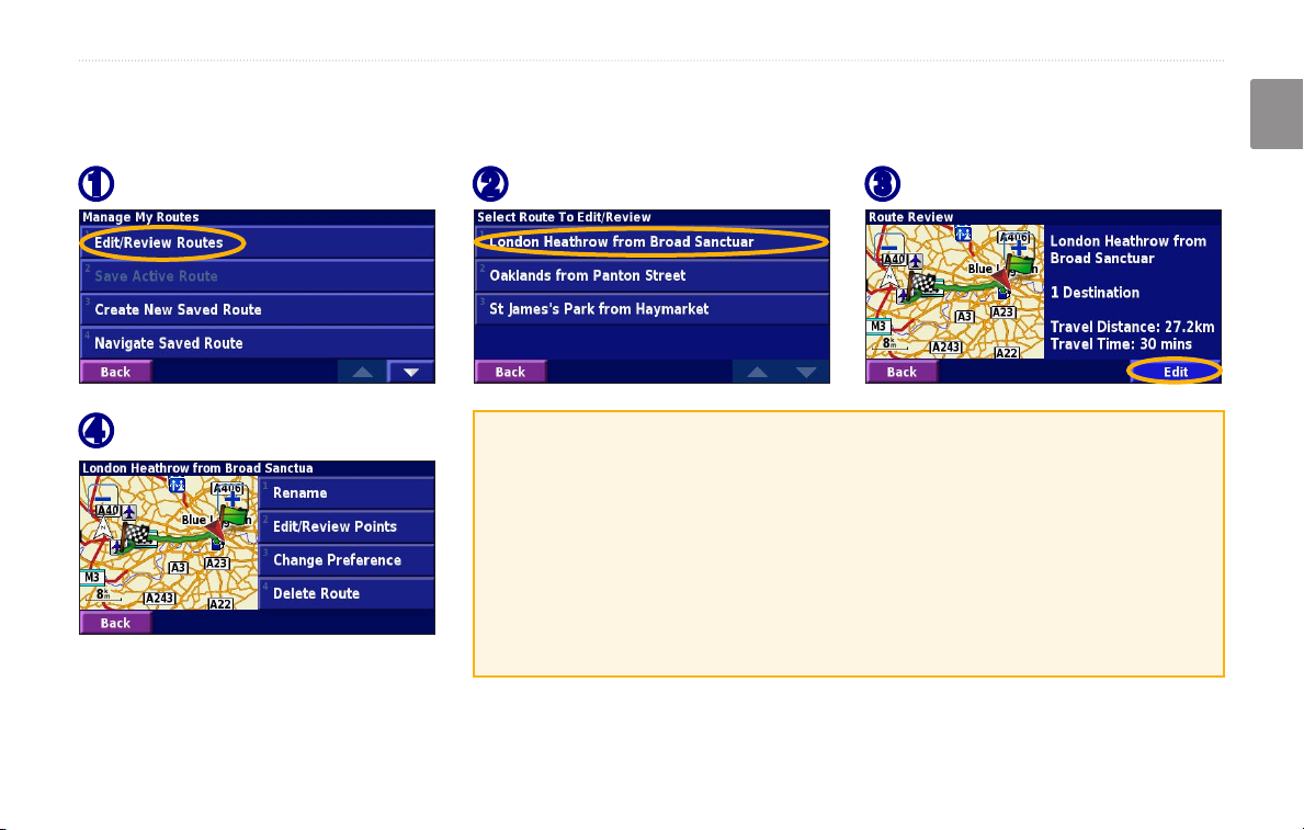
Editing a Saved Route
From the Menu page, touch Tools > My Data > Routes.
CREATING AND EDITING ROUTES
English
Touch Edit/Review Routes.
➊
Touch the item to edit.
➍
KNA-G520 Instruction Manual EN-15
Touch the route to edit.
➋
Rename—enter a new name for the route using the on-screen keyboard.
Edit/Review Points—add, arrange, remove, re-order, and review points
in the route. For more info, see the next page.
Change Preference—change calculation preference to Faster Time,
Shorter Distance, or Off Road.
Delete Route—delete this route.
Touch Edit.
➌
CREATING AND EDITING ROUTES
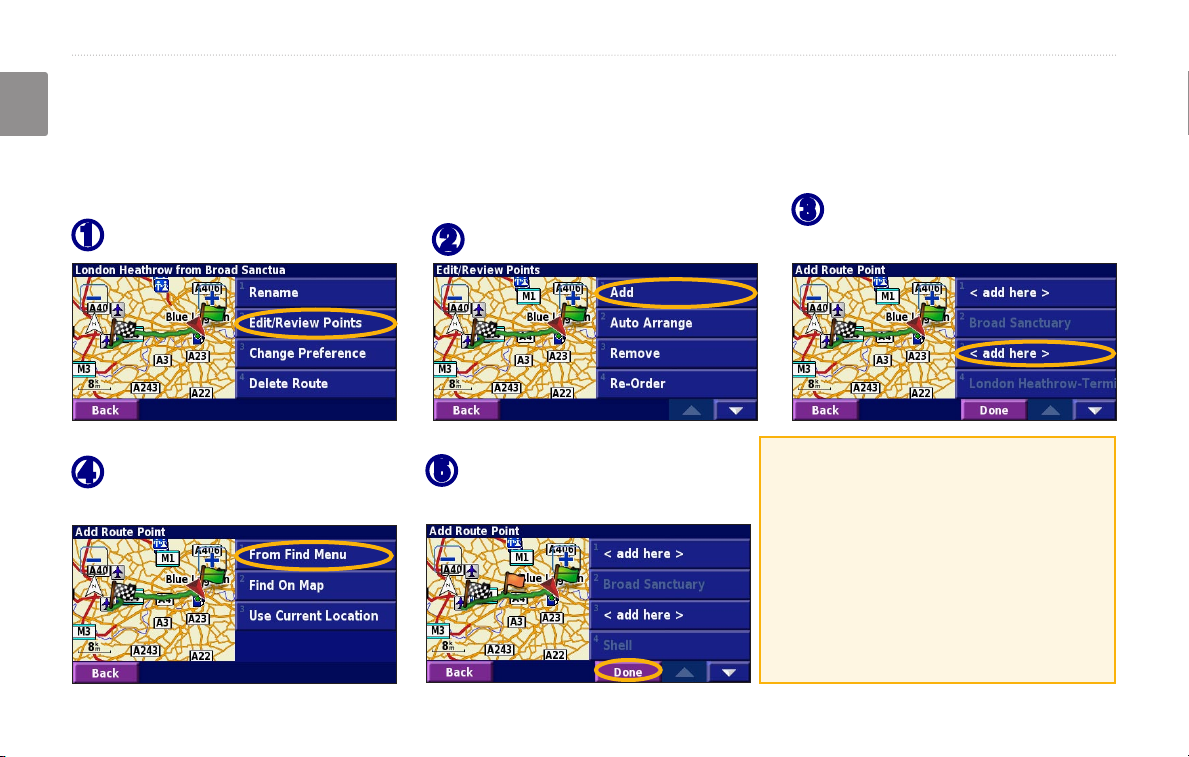
Adding Stops to Your Route
You can add midpoints (also called via points or stops) to your route as you create it, as described on page 14. You
English
can also add points to your route when you edit the route, as described below. Follow the steps on the previous page
to begin editing the route.
Touch where you to want to
Touch Edit/Review Points.
➊
Touch Add.
➋
➌
add the point.
Touch a method and then
➍
select the point.
EN-16 KNA-G520 Instruction Manual
Add points as necessary.
➎
Touch Done when finished.
Auto Arrange—arranges the points
to provide the shortest route.
Remove—touch the point you want
to remove and then touch Remove.
Re-Order—touch the point to move
and touch Move Up or Move Down.
Touch Done when finished.

Saving the Active Route
From the Menu page, touch Tools > My Data >
Routes > Save Active Route.
CREATING AND EDITING ROUTES
English
Adding a Detour to a Route
If you need to take a detour from your current route,
open the Menu page and touch Detour.
Navigating a Saved Route
From the Menu page, touch Tools > My Data >
Routes > Navigate Saved Route. Touch the route
you want to navigate.
1 kilometer, 5 kilometers, or 10 kilometers—select
the distance of the detour. For example if a road sign
indicates that the street is closed for the next five
kilometers, touch 5 kilometers in the list. The navigation
system recalculates your route for the next five
kilometers.
Recalculating the Route
From the Menu page, touch Tools > My Data >
Routes > Recalculate Route.
Deleting All Saved Routes
From the Menu page, touch Tools > My Data >
Routes > > Delete All Saved Routes.
Detour by Road(s) In Route—select roads in your route
to avoid. For example, if the highway ramp is closed,
select the ramp in the list of roads. The navigation
system recalculates your route to avoid that ramp.
Detour by Traffic Event on Route—if you are using
an FM Traffic Receiver, you can detour around traffic
events.
Stopping Your Route
From the Menu page, touch Stop. Then touch Yes.
KNA-G520 Instruction Manual EN-17
Remove All Detours—touch to remove any detours you
have entered for the route.
CREATING AND EDITING ROUTES
Adding Avoidances
From the Menu page, touch Settings > Navigation > > Avoidance Setup. Select the road type to avoid. Touch
English
to view more road types to avoid.
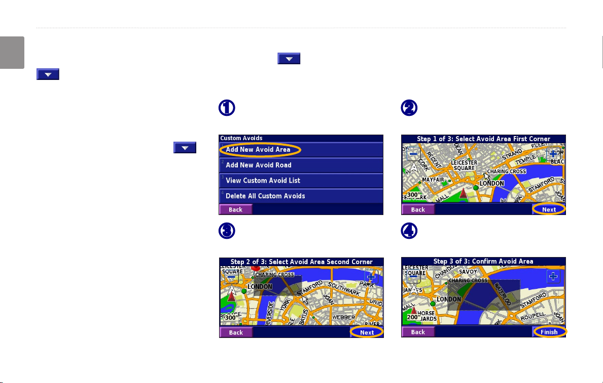
Creating Custom Avoids
You can enter specific areas and roads
to avoid in your routes. From the
Avoidance Setup menu, touch
two times and then touch Custom
Avoids.
EN-18 KNA-G520 Instruction Manual
Touch Add New Avoid Area
➊
or Add New Avoid Road.
Touch the second corner
➌
and touch Next.
Touch the first corner
➋
and touch Next.
Touch Finish.
➍
USING THE LOGS
USING THE LOGS
English
Adjusting the Track Log
As you travel, the navigator creates a bread crumb trail
(track log) of your movement. From the Menu page,
touch Tools > My Data > Track Log.
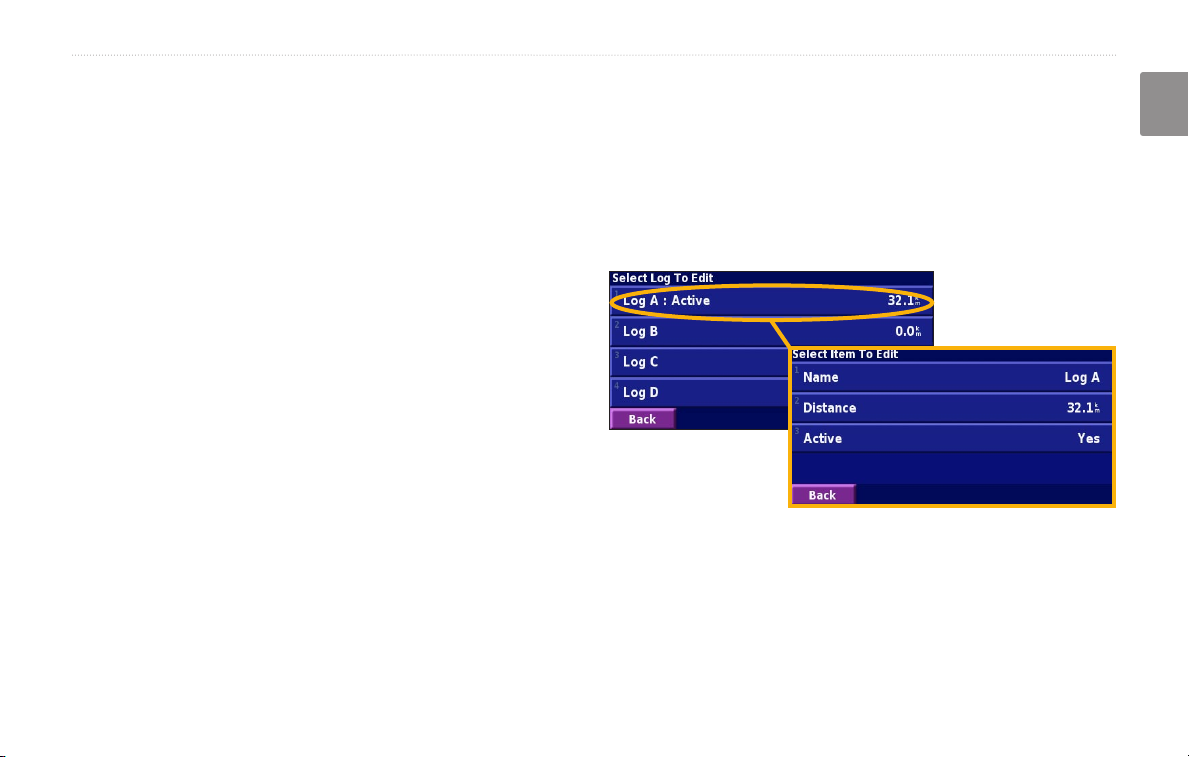
Using the Mileage Logs
You can keep four different mileage logs of your travels.
From the Menu page, touch Tools > My Data > Mileage
Log. Touch a log to edit it.
Recording—turn off and on the track log recorder.
Percentage Full—displays the current percentage
capacity of the track log. To clear the track log, touch
Percentage Full > Yes > OK.
Map Display—displays the current track log on the
map. Select a zoom setting at which the track log is
shown. Touch OK. Your track log is displayed as a fine
dotted line on the map.
Name—enter a new name.
Distance—reset the mileage log.
Active—make this log active or inactive.
KNA-G520 Instruction Manual EN-19
TRAFFIC INFORMATION
TRAFFIC INFORMATION
English
Using an optional FM Traffic Receiver, the navigation
system can receive and use traffic information. When a
traffic message is received, you can see the event on the
map and change your route to avoid the traffic incident.
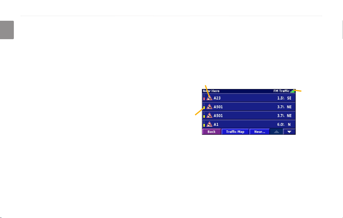
Viewing Traffic Events
From the Menu page, touch Tools > Traffic Info. Select
an item in the Traffic Events list to view the details.
Touch Near… to view traffic at a different location.
For more information about the FM Traffic Receiver,
visit the Garmin Web site (
www.garmin.com). For
participating FM subscription providers and covered
cities, refer to http://www.garmin.com/fmtraffic.
Make sure the FM Traffic Receiver is connected to the
KNA-G520. Refer to the Installation Guide for more
information.
EN-20 KNA-G520 Instruction Manual
Traffic Symbol
Color
code
Traffic
source
and
signal
strength
Traffic Events List
TRAFFIC INFORMATION
Avoiding Traffic
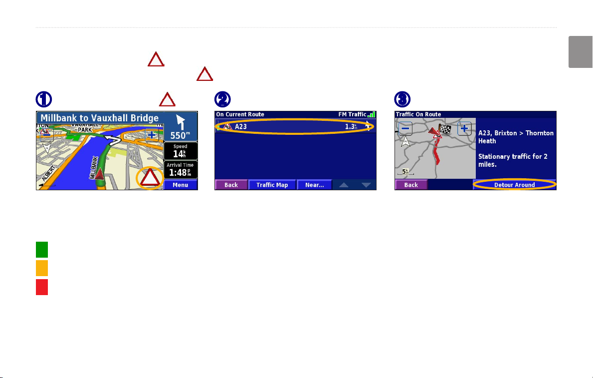
The map page displays a when there is a traffic event on your current route or on the road you are driving. When
you are following a route, touch the to avoid the traffic.
English
From the map, touch .
➊
Touch an item to avoid.
➋
Touch Detour Around.
➌
Severity Color Code
The bars to the left of the traffic symbols indicate the severity of the traffic incident:
= Low severity (green); traffic is still flowing.
= Medium severity (yellow); traffic is a bit congested.
= High severity (red); traffic is heavily congested or stopped.
KNA-G520 Instruction Manual EN-21
TRAFFIC INFORMATION
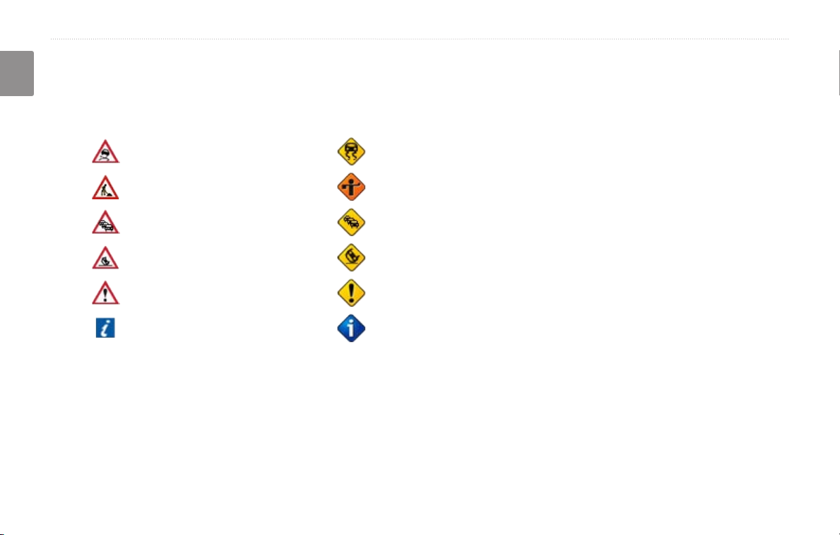
Traffic Symbols
English
International
Symbols
Meaning
Road Condition
Road Construction
Congestion
Accident
Incident
Information
North
American
Symbols
Changing the Traffic Settings
From the Menu page, touch Settings > Traffic.
Subscriptions—view your traffic subscriptions. Touch
the subscription to display the expiration date. To add a
subscription, touch Add Subscription. See the next page
for information about adding an FM Traffic subscription.
Symbols on Map—change the symbols used to indicate
the type of traffic event. Touch Style to use American
or International symbols. Touch each symbol to set the
zoom scale at which each symbol appears on the map.
Severity on the Map—select the scale at which the
severity is displayed on the map.
Audio Notification—turn on or off the audio notification
when a traffic event occurs on the road you are traveling
on or the route you are navigating.
Avoid Traffic
—select Yes to avoid traffic events when
generating a route.
EN-22 KNA-G520 Instruction Manual
TRAFFIC INFORMATION
Adding a Traffic Subscription
Your FM Traffic Receiver may come with a subscription, or you may be in an area with free service. You can also add
subscriptions to expand your service area. Touch Settings > About > FM Traffic Receiver and write down your FM
Traffic Receiver’s unit ID. Go to http://www.garmin.com/fmtraffic to purchase a traffic subscription and get a 25character traffic subscription code.
English
Touch Settings.
➊
Touch Next.
➎
KNA-G520 Instruction Manual EN-23
Touch Traffic.
➋
Enter the code and
➏
touch Next.
Touch
➌
Subscriptions.
Touch OK.
➐
Touch Add
➍
Subscription
CHANGING THE SETTINGS
CHANGING THE SETTINGS
English
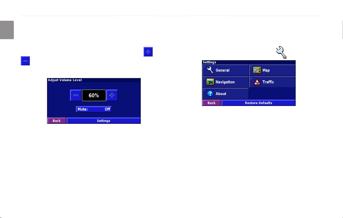
Adjusting the Volume
From the Menu page, touch Volume. Touch the and
to adjust the volume. Touch Mute to silence the
audio output.
Touch Settings to open the Audio Settings page. See
page 25 for more information.
Changing the General Settings
From the Menu page, touch Settings > General.
GPS
From the Menu page, touch Settings > General > GPS.
See page 13.
Changing the Language
From the Menu page, touch Settings > General >
Language.
EN-24 KNA-G520 Instruction Manual
 Loading...