


Bring in an image from Corp Comm at 300 DPI and then shrinkwrap the
anchored frame (ESC + m + P).

Jeppesen FliteDeck Pro User Guide
Jeppesen
55 Inverness Drive East
Englewood, Colorado 80112-5498
This document supports version 8.1 of Jeppesen FliteDeck Pro.
Minimum operating system requirement for Jeppesen FliteDeck Pro 8.1 is
Windows 8.1.
Copyright © 2014 Jeppesen. All rights reserved.
August 2014
Revision 1.0

Copyright © 2014 Jeppesen. All rights reserved.
Except as otherwise provided and authorized in a written agreement between both Jeppesen and your company, Jeppesen's
copyrighted information and materials may not be processed, reformatted, reproduced, stored in a retrieval system, or
transmitted in whole or in part, in any form or by any means, whether electrical, mechanical, photocopying, recording or
otherwise, without prior written permission of Jeppesen.
Surface is either a registered trademark or trademark of Microsoft in the United States and other countries.
Product or brand names may be trademarks or registered trademarks of their respective owners.

Contents
Jeppesen FliteDeck Pro User Guide 1
Jeppesen Support . . . . . . . . . . . . . . . . . . . . . . . . . . . . . . . . . . . . . . . . . . . . . . . . . . . . . . 1
The Views . . . . . . . . . . . . . . . . . . . . . . . . . . . . . . . . . . . . . . . . . . . . . . . . . . . . . . . . . . . . 2
Working in Enroute View . . . . . . . . . . . . . . . . . . . . . . . . . . . . . . . . . . . . . . . . . . . . . . . . . 2
Working in Terminal Charts View . . . . . . . . . . . . . . . . . . . . . . . . . . . . . . . . . . . . . . . . . . 2
Basic Touch Screen Gestures . . . . . . . . . . . . . . . . . . . . . . . . . . . . . . . . . . . . . . . . . . . . . 3
Pinch to Zoom . . . . . . . . . . . . . . . . . . . . . . . . . . . . . . . . . . . . . . . . . . . . . . . . . . . . . . . . . 3
Touch, Hold, then Release . . . . . . . . . . . . . . . . . . . . . . . . . . . . . . . . . . . . . . . . . . . . . . . . 3
Double-tap to Zoom Out . . . . . . . . . . . . . . . . . . . . . . . . . . . . . . . . . . . . . . . . . . . . . . . . . 3
One-finger Swipe to Pan . . . . . . . . . . . . . . . . . . . . . . . . . . . . . . . . . . . . . . . . . . . . . . . . . 3
Two-finger Swipe to Navigate Through Terminal Charts . . . . . . . . . . . . . . . . . . . . . . . . 3
The Toolbar . . . . . . . . . . . . . . . . . . . . . . . . . . . . . . . . . . . . . . . . . . . . . . . . . . . . . . . . . . . 4
Specifying Which Manuals are Available for View . . . . . . . . . . . . . . . . . . . . . . . . . . . . . 5
Viewing Selected Manuals . . . . . . . . . . . . . . . . . . . . . . . . . . . . . . . . . . . . . . . . . . . . . . . . 6
Viewing Change Notices . . . . . . . . . . . . . . . . . . . . . . . . . . . . . . . . . . . . . . . . . . . . . . . . . 6
Adjusting Brightness and Night Theme . . . . . . . . . . . . . . . . . . . . . . . . . . . . . . . . . . . . . . 7
Identifying GPS Status . . . . . . . . . . . . . . . . . . . . . . . . . . . . . . . . . . . . . . . . . . . . . . . . . . . 7
Accessing Settings . . . . . . . . . . . . . . . . . . . . . . . . . . . . . . . . . . . . . . . . . . . . . . . . . . . . . . 8
Performing Updates . . . . . . . . . . . . . . . . . . . . . . . . . . . . . . . . . . . . . . . . . . . . . . . . . . . . . 9
Locking the Display . . . . . . . . . . . . . . . . . . . . . . . . . . . . . . . . . . . . . . . . . . . . . . . . . . . . 11
Enroute View . . . . . . . . . . . . . . . . . . . . . . . . . . . . . . . . . . . . . . . . . . . . . . . . . . . . . . . . . 12
Creating a Route from the Route Drawer . . . . . . . . . . . . . . . . . . . . . . . . . . . . . . . . 13
Adding Route Points from the Route Drawer . . . . . . . . . . . . . . . . . . . . . . . . . . . . . . . . . 14
Adding a SID and a STAR . . . . . . . . . . . . . . . . . . . . . . . . . . . . . . . . . . . . . . . . . . . . . . . 15
Editing a Route by Interacting with the Map . . . . . . . . . . . . . . . . . . . . . . . . . . . . . . 16
Viewing High and Low Enroute Themes . . . . . . . . . . . . . . . . . . . . . . . . . . . . . . . . 17
Changing Map Orientation . . . . . . . . . . . . . . . . . . . . . . . . . . . . . . . . . . . . . . . . . . . . 17

Contents
Displaying the Ownship Symbol on the Enroute Map . . . . . . . . . . . . . . . . . . . . . . . 18
Viewing Present Position . . . . . . . . . . . . . . . . . . . . . . . . . . . . . . . . . . . . . . . . . . . . . 18
Viewing Enroute Map Features . . . . . . . . . . . . . . . . . . . . . . . . . . . . . . . . . . . . . . . . 19
Viewing Map Details . . . . . . . . . . . . . . . . . . . . . . . . . . . . . . . . . . . . . . . . . . . . . . . . 20
Searching in Enroute View . . . . . . . . . . . . . . . . . . . . . . . . . . . . . . . . . . . . . . . . . . . . . . . 21
Viewing Distance Calculations . . . . . . . . . . . . . . . . . . . . . . . . . . . . . . . . . . . . . . . . 22
Determining Distance with the Offset Indicator . . . . . . . . . . . . . . . . . . . . . . . . . . . . 22
Accessing Enroute Operational Notes . . . . . . . . . . . . . . . . . . . . . . . . . . . . . . . . . . . 23
Removing Current Flight Information . . . . . . . . . . . . . . . . . . . . . . . . . . . . . . . . . . . 23
Terminal Charts View . . . . . . . . . . . . . . . . . . . . . . . . . . . . . . . . . . . . . . . . . . . . . . . . . 24
Accessing Terminal Charts for Your Route . . . . . . . . . . . . . . . . . . . . . . . . . . . . . . . 25
Selecting Charts for Your Flight . . . . . . . . . . . . . . . . . . . . . . . . . . . . . . . . . . . . . . . 26
Navigating Between Selected Charts . . . . . . . . . . . . . . . . . . . . . . . . . . . . . . . . . . . . 26
Viewing Charts for Airports in Your Route . . . . . . . . . . . . . . . . . . . . . . . . . . . . . . . 27
Viewing Charts for Airports Not In Your Route . . . . . . . . . . . . . . . . . . . . . . . . . . . 27
Working with Hand-Drawn Notes . . . . . . . . . . . . . . . . . . . . . . . . . . . . . . . . . . . . . . 28
Highlighting a Chart . . . . . . . . . . . . . . . . . . . . . . . . . . . . . . . . . . . . . . . . . . . . . . . . . 29
Rotating a Chart . . . . . . . . . . . . . . . . . . . . . . . . . . . . . . . . . . . . . . . . . . . . . . . . . . . . 29
Displaying the Ownship Symbol on the Airport Diagram . . . . . . . . . . . . . . . . . . . . 30
Jeppesen FliteDeck Pro App Settings . . . . . . . . . . . . . . . . . . . . . . . . . . . . . . . . . . . . . 31
Updates, Application Help, and Reset Features . . . . . . . . . . . . . . . . . . . . . . . . . . . . . . . 31
Sleep Mode Setting . . . . . . . . . . . . . . . . . . . . . . . . . . . . . . . . . . . . . . . . . . . . . . . . . . . . . 32
Enroute View Settings . . . . . . . . . . . . . . . . . . . . . . . . . . . . . . . . . . . . . . . . . . . . . . . . . . . 33
Terminal Charts View Settings . . . . . . . . . . . . . . . . . . . . . . . . . . . . . . . . . . . . . . . . . . . . . 34
Account Info Settings . . . . . . . . . . . . . . . . . . . . . . . . . . . . . . . . . . . . . . . . . . . . . . . . . . . . 34
Support Information and Deactivation Information . . . . . . . . . . . . . . . . . . . . . . . . . . . . 35
Jeppesen FliteDeck Pro User Guide August 2014
Copyright © 2014 Jeppesen. All rights reserved.
vi

Jeppesen FliteDeck Pro
User Guide
Jeppesen Support
North America Toll Free: 800-978-9186
United States: 303-328-6175
International: +49-6102-508290
Email: techsupport@jeppesen.com
The Views
Working in Enroute View
The Views
Jeppesen FliteDeck Pro helps you increase your situational
awareness by viewing your flight with respect to both the
terminal and enroute air structures.
The two main views in Jeppesen FliteDeck Pro are the Enroute
view and the Terminal Charts view. You enter origin, destination,
and any alternate airports in the Enroute view, and then you
retrieve the terminal charts for those route airports in the
Terminal Charts view.
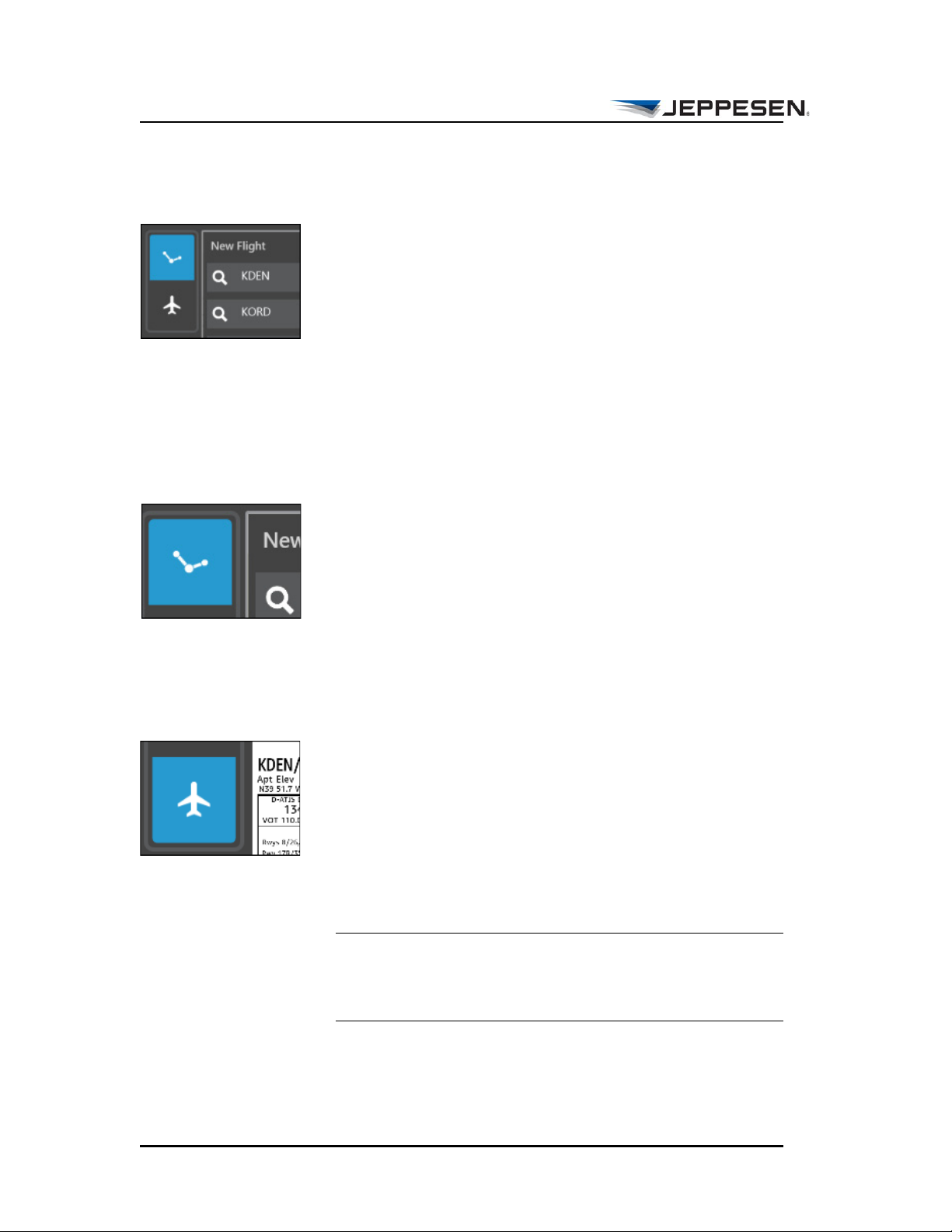
Working in Enroute View
To plan, create, and edit your route:
• Tap the Enroute view button.
From this view, you can also view map details, search for map
information, view range rings, and access manuals, operational
notes, and EFB change notices.
Working in Terminal Charts View
To access terminal charts for your route:
• Tap the Terminal Charts view button.
From this view, you can rotate your terminal chart, search for
other charts, zoom in and out, view chart change notices, access
manuals, and add highlights and hand-drawn notes to a particular
chart.
NOTE After you create a route in the Enroute view, the first
time that you tap the Terminal Charts view button, the
default airport diagram appears for the origin airport of
your current flight.
Jeppesen FliteDeck Pro User Guide August 2014
Copyright © 2014 Jeppesen. All rights reserved.
2
Basic Touch Screen Gestures
Pinch to Zoom
Zoom in and out of the display by moving your thumb and finger
in a pinching gesture.
Basic Touch Screen Gestures
Pinch to Zoom
Touch, Hold, then Release
You can touch, hold, and then release any object on the enroute
map to view more information about it. For certain types of
objects, you can add them to your route or, if they are already part
of the route, remove them from the route.
Double-tap to Zoom Out
Double-tap one finger to zoom out to the full extent of your route
(in Enroute view) or to the full extent of the chart (in Terminal
Charts view).
One-finger Swipe to Pan
Swipe one finger to pan the enroute map and terminal charts.
You also use one finger to scroll through your chart clip when the
number of charts extends beyond the edge of the screen.
Two-finger Swipe to Navigate Through Terminal Charts
Swipe two fingers to flip through your selected terminal charts,
similar to flipping through pages in a book. Depending on your
zoom level, you might need to pan to the edge of the chart to
swipe to the next chart.
August 2014 Jeppesen FliteDeck Pro User Guide
Copyright © 2014 Jeppesen. All rights reserved.
3
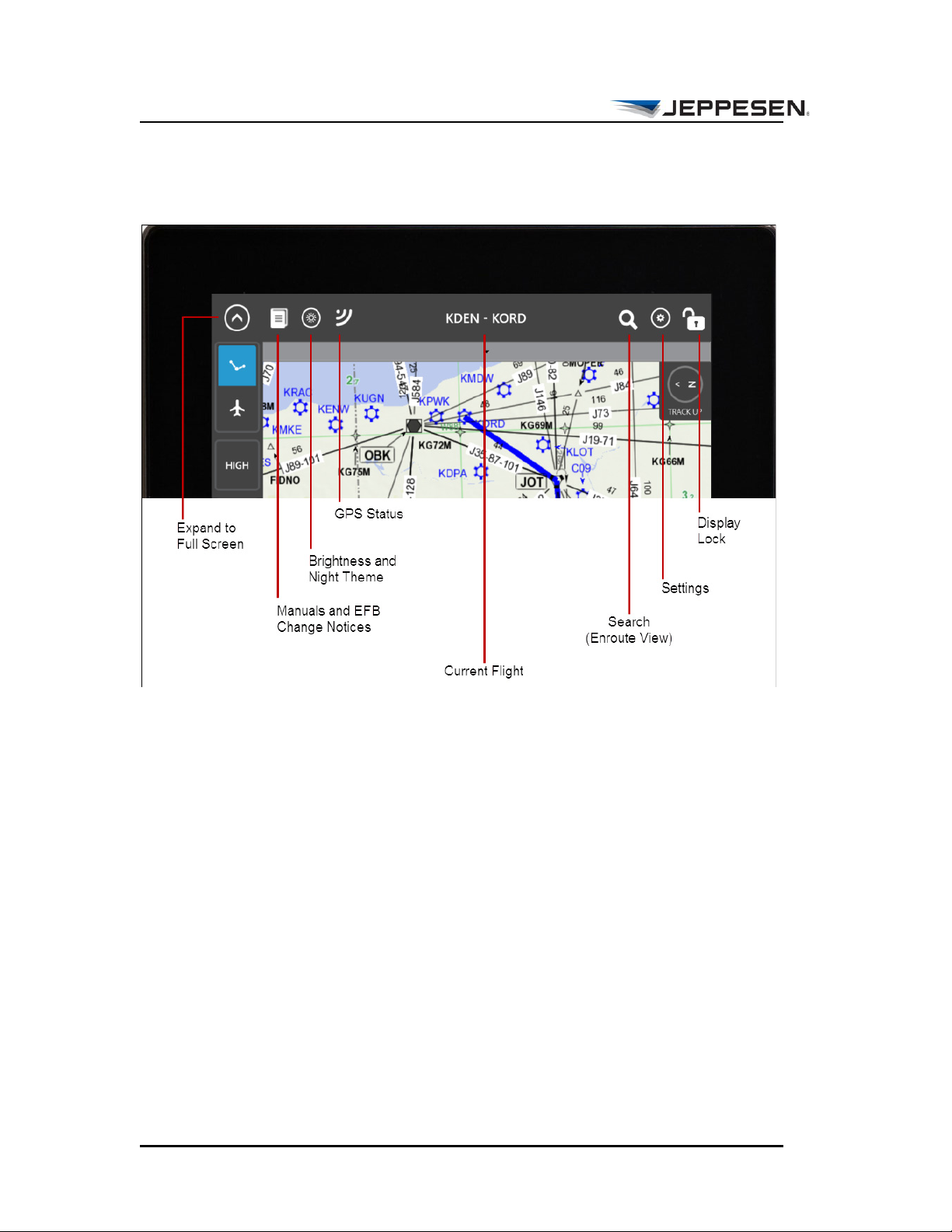
The Toolbar
Two-finger Swipe to Navigate Through Terminal Charts
The Toolbar
Jeppesen FliteDeck Pro User Guide August 2014
Copyright © 2014 Jeppesen. All rights reserved.
4
The Toolbar
Specifying Which Manuals are Available for View
Specifying Which Manuals are Available for
View
Your organization determines which manuals are delivered to
your device. However, before you can access and view the
manuals, you must first specify which manuals you want to have
available when you tap the Manuals button. To specify which
manuals are available:
1. Tap the Settings button.
2. Tap Updates.
3. Tap the Manuals flyout.
A list of the manuals that your organization has made
available for your device appears.
4. Tap to specify the manuals that you want to load onto your
device.
A check mark appears next to each manual title that you
select.
5. Tap Save.
6. Tap Close on the Updates panel.
August 2014 Jeppesen FliteDeck Pro User Guide
Copyright © 2014 Jeppesen. All rights reserved.
5
The Toolbar
Viewing Selected Manuals
Viewing Selected Manuals
After you have specified the manuals that you want to have
available, you can view them at any time, in either Enroute view
or Terminal Charts view. You must have a PDF reader app
installed on your device to view manuals.
To view selected manuals:
1. Tap the Manuals button.
2. Tap to select the manual that you want to view.
3. Tap to select the PDF reader app of your choice.
The manual opens in snap view. You can use the handle
between the two screens to increase or decrease the size of
each screen. To view the PDF reader app in full-screen
mode, swipe from the far left. Your device toggles between
open apps.
NOTE If your company subscribes to Jeppesen Document
Management Services, you can also access company
manuals from within Jeppesen FliteDeck Pro by
following the same steps.
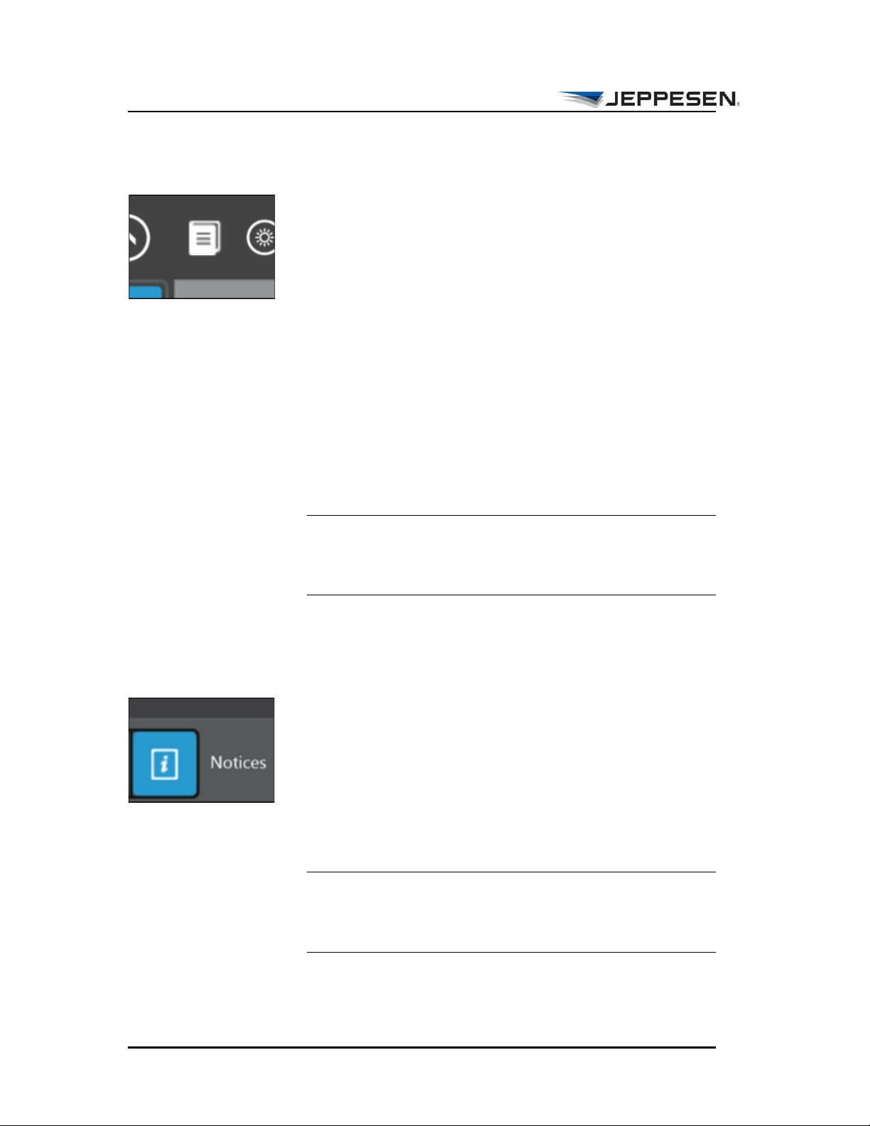
Viewing Change Notices
Change notices notify you of changes that apply to the enroute
map or to terminal charts that have not yet been published.
To view change notices:
1. Tap the Manuals button.
2. Tap the Notices button at the bottom of the Manuals dialog
box.
NOTE Change notices are available based on your current
view. In the Enroute view, EFB change notices are
available by region. In the Terminal Charts view, chart
change notices are based on the selected airport.
Jeppesen FliteDeck Pro User Guide August 2014
Copyright © 2014 Jeppesen. All rights reserved.
6
The Toolbar
Adjusting Brightness and Night Theme
Adjusting Brightness and Night Theme
To adjust the display brightness:
1. Tap the Brightness button on the FliteDeck Pro toolbar.
2. Tap Adjust Screen Brightness.
The Settings flyout appears.
3. Tap Screen.
4. Slide the brightness control to decrease or increase the
display brightness.
To adjust for optimal viewing in low-light conditions, switch the
Night Theme to On.
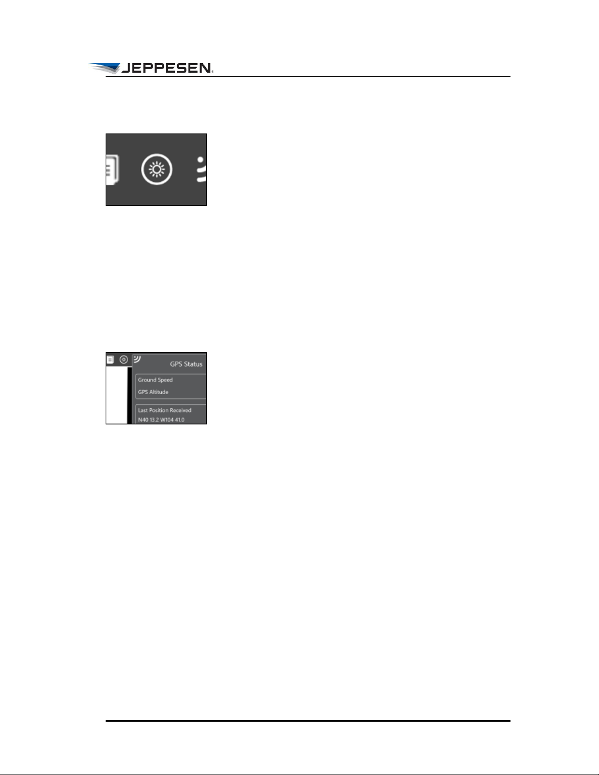
Identifying GPS Status
The GPS Status button appears on the FliteDeck Pro toolbar if
your device has GPS functionality and either the Enable Moving
Map or the Display Ownship on Airport Diagram setting is set to
On in app settings.
Tap the GPS Status button to view the current ground speed,
GPS altitude, last position received, and accuracy status.
A badge appears over the GPS Status button if the GPS signal
does not meet the minimum accuracy requirement. Jeppesen
FliteDeck Pro displays the ownship symbol when the GPS signal
is within:
• 200 meters of the aircraft’s current position for the enroute
map.
• 17 meters of the aircraft’s current position for a terminal
chart.
August 2014 Jeppesen FliteDeck Pro User Guide
Copyright © 2014 Jeppesen. All rights reserved.
7

The Toolbar
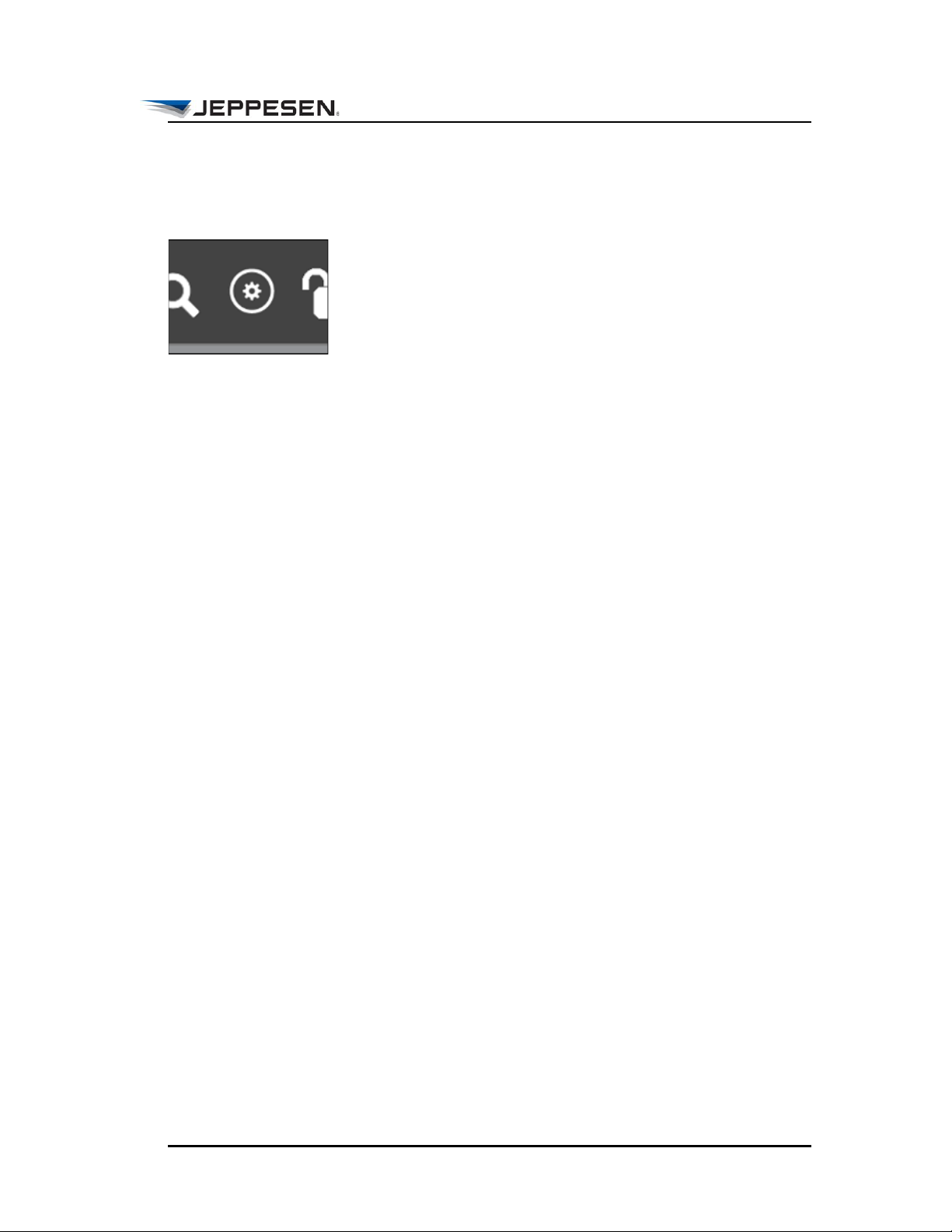
Accessing Settings
Accessing Settings
From the Settings popover, you can do the following:
• Perform updates. See “Performing Updates” on page 9
for
more information.
• View app help.
• Reset all user settings to their default values.
• Clear routes and custom content.
• Turn Sleep Mode On or Off.
• Enable the moving map and display the ownship symbol on
either the enroute map or on terminal charts.
• Show or hide the terrain legend on the enroute map. (The
terrain legend appears only if the terrain button is toggled
On to show terrain in the Enroute view. See “Viewing
Enroute Map Features” on page 19 for more information
about Terrain.)
• Display the ownship symbol on the airport diagrams.
• Show the taxi diagram on landing and set the speed
threshold to determine when the taxi diagram displays.
• Set the default terminal chart zoom level.
• View information about the app, such as the version of the
app and your account information.
• Deactivate the application.
• Access Jeppesen Support information.
Jeppesen FliteDeck Pro User Guide August 2014
Copyright © 2014 Jeppesen. All rights reserved.
8

The Toolbar
Performing Updates
Performing Updates
When data updates are available, a badge appears on the Settings
button.
To perform updates:
1. Tap the Settings button.
2. To view available updates, tap the Updates button.
3. Tap Update at the bottom of the dialog box.
IMPORTANT During the update process, avoid disabling your
WIFI or Internet connection, and avoid placing
your device in Airplane mode. Doing so
interrupts the update and can cause
unpredictable results.
4. Tap Close when the update is complete.
NOTE The download time depends on your connection to the
Internet and the size of the required updates. At any
time during the update, you can tap Cancel or Exit to
cancel the download and continue to use the data that
was previously installed.
Understanding Updates
The data delivery system for Jeppesen FliteDeck Pro can track,
report on, and audit updates to devices globally.
When more than one version of Jeppesen terminal chart or
enroute data is available, FliteDeck Pro uses amber-colored
notifications to indicate multiple versions.
August 2014 Jeppesen FliteDeck Pro User Guide
Copyright © 2014 Jeppesen. All rights reserved.
9

The Toolbar
Performing Updates
Midcycle Terminal Chart Updates
Jeppesen FliteDeck Pro updates terminal charts according to your
company’s subscription. When a terminal chart is revised
midcycle, the revision date appears along with the amber tag next
to the chart title on the chart list.
To change terminal chart versions when more than one version of
the chart is available:
1. Tap the amber tag from the chart list.
The Chart Versions popover appears.
2. On the Chart Versions popover, tap to select the version
that you want to use.
Enroute Database Effectivity
Jeppesen FliteDeck Pro updates the enroute database every 28
days. The app automatically switches to the current database
when it takes effect (if you downloaded the database). Because
you can download enroute data up to seven days before the
effective date, two versions of the enroute database can exist on
your device at the same time.
Twenty-four hours before a database expires, FliteDeck Pro
displays an amber flag on the map to indicate that the current
database expires soon. Also, if you select a database that either is
expired or is not yet effective, FliteDeck Pro displays a similar
amber flag that indicates the status of the data (that is, whether
the data is expired or is not yet effective, respectively).
To change enroute database versions when more than one version
of enroute data is available:
1. Tap the Settings button.
2. Tap Updates.
3. Tap the Enroute Effective Date flyout.
4. Tap to select the database that you want to use.
5. Close the flyout.
6. Tap Close.
Jeppesen FliteDeck Pro User Guide August 2014
Copyright © 2014 Jeppesen. All rights reserved.
10

The Toolbar
Locking the Display
Locking the Display
The display lock feature locks the current view so that you don’t
accidentally pan or zoom away from information you need—for
example, during critical phases of flight.
To lock or unlock your display:
• Tap the Display Lock button.
When you lock the display, the Display Lock button is orange.
All other app buttons are disabled, as are the panning and
zooming features. Locking the display also locks the current
orientation. You can still access Windows charms and you can
still swipe to move between open applications.
August 2014 Jeppesen FliteDeck Pro User Guide
Copyright © 2014 Jeppesen. All rights reserved.
11

Enroute View
Locking the Display
Enroute View
IMPORTANT Although the Enroute view displays navigational
data and an ownship symbol, it is designed to
enhance situational awareness and is not
intended as a navigational tool. Use other tools
on the flight deck to navigate the aircraft.
Jeppesen FliteDeck Pro User Guide August 2014
Copyright © 2014 Jeppesen. All rights reserved.
12

Creating a Route from the Route Drawer
Creating a Route from the Route Drawer
You can plan, create, and edit your route from the Route Drawer,
including adding multiple alternate airports, route points, and
SIDs and STARs.
To create a route using the Route Drawer:
Enroute View
1. Tap the Route Drawer Bar.
The app opens the Route Drawer.
2. Tap in the Origin box and enter the four-letter ICAO
identifier or city name for the origin airport.
3. Tap in the Destination box and enter the four-letter ICAO
identifier or city name for the destination airport.
4. Tap in the Enter Alternate Airport box and enter the fourletter ICAO identifier or city name for the alternate airport.
You can enter multiple alternates. Separate each alternate
with a space. If more than one option is available, a list
displays multiple airports from which you can choose.
5. Dismiss the keyboard.
Airports that are part of your route, including any alternates
that you specify, persist on the map regardless of whether
you exclude airports from the Enroute map.
NOTE If you enter an invalid airport ICAO identifier, a
message appears at the bottom of the route box
stating that the airport was not found.
To search for airports:
1. In the Origin or the Destination box (or in the Enter
Alternate Airport box), enter at least two characters of the
airport ICAO or IATA identifier, airport name, or city
name.
2. Tap the Search key.
3. Tap the desired airport from the search results.
August 2014 Jeppesen FliteDeck Pro User Guide
Copyright © 2014 Jeppesen. All rights reserved.
13

Enroute View
Adding Route Points from the Route Drawer
Adding Route Points from the Route
Drawer
You can add route points (navaids, airways, airports, and
waypoints) to your route from the Route Drawer.
To add route points to your route:
1. Tap the Route Drawer Bar, which opens the Route
Drawer.
2. Tap in the Route box.
3. Using the keyboard, or by copying and pasting, enter the
route points into the route box.
4. Dismiss the keyboard.
Use dot notation to enter multiple sequential waypoints. When
you use dot notation, enter:
• Two dots between direct-to points. For example:
FXV..FWA..CR
• One dot between via routings (points that begin and end
airway segments and SID/STAR procedures). For example:
LULOX.UN12.IDOKI.UM25.INGOR.UM25.DVL
NOTE In addition, the following formats for latitude and
longitude coordinates are supported in the Route box:
Nxx Wxxx (N 37 W122)
Nxx.x Wxxx.x (N37.5 W122.2)
Nxx xx.x Wxxx xx.x (N37 56.6 W122 21.4)
Nxx xx.xx Wxxx xx.xx (N37 56.60 W122 21.40)
N xx.xxxxx W xxx.xxxxx (N 37.56600 W 122.21400)
N xx xx W xxx xx (N 37 56 W 122 21)
N xx xx xx W xxx xx xx (N 37 56 60 W 122 21 40)
Jeppesen FliteDeck Pro User Guide August 2014
Copyright © 2014 Jeppesen. All rights reserved.
14

Enroute View
Adding a SID and a STAR
Adding a SID and a STAR
You can add a SID and a STAR to your route. Departure and
arrival procedures are depicted as a dotted line on the enroute
map. Before you can enter a SID or a STAR, you must first enter
the corresponding origin and destination airports.
To enter a SID or a STAR:
1. Open the Route Drawer.
2. Tap either SID or STAR, and then follow the prompts to
enter runways, procedures, and transitions.
• For SIDs, FliteDeck Pro prompts you to select
a runway, a procedure, and a transition.
• For STARs, FliteDeck Pro prompts you to
select a procedure and a transition.
NOTE For some procedures, FliteDeck Pro might prompt you
for different information. Note also that FliteDeck Pro
depicts only transition points of a SID or STAR on the
enroute map.
IMPORTANT The depiction of a SID or a STAR on the
enroute map is intended for situational
awareness only. Always refer to the appropriate
terminal chart for detailed guidance when
carrying out departure and arrival procedures.
Note that at certain zoom levels, the enroute
map includes a reminder to refer to the terminal
chart. The reminder appears along the
procedure’s dotted route line.
August 2014 Jeppesen FliteDeck Pro User Guide
Copyright © 2014 Jeppesen. All rights reserved.
15

Enroute View
Editing a Route by Interacting with the Map
Editing a Route by Interacting with the Map
You can add or remove route points from your route directly from
the map—without having to enter or delete information in the
Route box. For example, you can add established navaids,
established waypoints, and airports.
NOTE Although airways are depicted on the Enroute map, to
include an airway segment in your route, you must use
dot notation to designate the airway in the Route Box.
However, for a given airway segment, if you specify
valid entry and exit waypoints directly from the map,
FliteDeck Pro draws the route line as if you had
specified the associated airway segment.
To edit your route by interacting with the map:
1. Touch, hold, and then release the desired route point on the
map.
Depending on where you touch, FliteDeck Pro provides
various options:
• If you touch an airport, an established waypoint or a navaid,
a dialog box appears with information about the object. The
dialog box includes options to add the object to your route
or to remove the object if it is already part of the route.
Follow the prompts to add the object in the correct sequence
in your route or to remove the object.
• If you touch a congested area of the map, the Multiple
Objects dialog box appears. You must specify the object
that you intended to work with—or create a user-defined
waypoint.
When you specify an established waypoint, navaid, or an
airport, its dialog box appears and includes the options to
add the object to your route or (if applicable) to remove it.
Follow the prompts to add the object in the correct sequence
in your route or to remove the object.
When you select the option to create a user-defined
waypoint, FliteDeck Pro creates a lat/long waypoint that
Jeppesen FliteDeck Pro User Guide August 2014
Copyright © 2014 Jeppesen. All rights reserved.
16

Viewing High and Low Enroute Themes
corresponds to the point on the map where you touched.
Follow the prompts to add the waypoint in the correct
sequence in your route.
2. Tap Add To Route or Remove From Route.
NOTE You can tap the unfilled star next to a user-created
waypoint to fill the star and to ensure that the waypoint
persists on the map after the route has been cleared.
You can clear the user-created waypoint by tapping
the star again.
Viewing High and Low Enroute Themes
The same high and low themes as depicted on precomposed
(paper) enroute charts are available for the enroute map.
Enroute View
To alternate between enroute map themes:
• Tap the Enroute Theme button.
Changing Map Orientation
To change the enroute map orientation, tap the North Up or
Track Up button.
To use Track Up, your device must have GPS capability and you
must switch Enable Moving Map to On in JeppFD-Pro app
settings.
August 2014 Jeppesen FliteDeck Pro User Guide
Copyright © 2014 Jeppesen. All rights reserved.
17

Enroute View
Displaying the Ownship Symbol on the Enroute Map
Displaying the Ownship Symbol on the Enroute Map
The ownship symbol shows the present position of the aircraft on
the Enroute moving map. The ownship symbol is available on the
enroute map when both Enable Moving Map and Display
Ownship on Enroute are set to On in JeppFD-Pro app settings and
the minimum GPS accuracy requirement is met.
When valid ownship position and heading information is
available, Enroute displays a directional ownship symbol, which
has a triangular shape. The triangle tip of the ownship symbol
indicates estimated position.
When position information is valid but track/heading information
is not available, Enroute displays a nondirectional ownship
symbol, which has a circular shape. The symbol center indicates
estimated position.
Viewing Present Position
To recenter the map over your aircraft position after you have
panned away, tap the Present Position button.
The Present Position button is available in the Enroute view when
the minimum GPS accuracy requirement is met and Enable
Moving Map is set to On in JeppFD-Pro app settings.
Jeppesen FliteDeck Pro User Guide August 2014
Copyright © 2014 Jeppesen. All rights reserved.
18

Viewing Enroute Map Features
Depending on the zoom level, certain enroute map features are
automatically filtered to declutter the map. When a feature is
available for display, you can manually show or hide it by
tapping on its corresponding filter button.
To show or hide an enroute map feature:
Enroute View
Viewing Enroute Map Features
1. Zoom in until the map feature that you want to view is
enabled.
To determine whether a feature is available for view, note
whether its filter button is white or grayed out. If the button
is grayed out, the feature is not available at that zoom level.
2. Tap the filter button that corresponds to the specific enroute
map feature.
These are the map features that you can show or hide:
•Airports
•Airways
• Waypoints
• Navaids
• Airspaces
• Terrain
August 2014 Jeppesen FliteDeck Pro User Guide
Copyright © 2014 Jeppesen. All rights reserved.
19

Enroute View
Viewing Map Details
Viewing Map Details
To view map details:
• Touch, hold, and then release an object on the map.
Depending on the type of object that you select, you might have
the option to review more information about the object. For
example, when you view the details of an airport on the map, a
popover displays airport information, including:
• Information about runways.
• Communication information, such as call signs,
• Notes.
The selected object is highlighted in magenta, and a
popover displays the object detail.
frequencies, and service indicators.
•The Go To Airport Diagram button, which switches to the
default airport diagram for the selected airport.
Jeppesen FliteDeck Pro User Guide August 2014
Copyright © 2014 Jeppesen. All rights reserved.
20

Enroute View
Searching in Enroute View
Searching in Enroute View
To search for map information:
1. Tap the Search button.
2. Type two or more characters in the search box.
3. Tap the Search icon next to the search box or tap the
Search key on the virtual keyboard.
FliteDeck Pro lists the objects that match your criteria,
ordered from closest to farthest from the center of the map.
NOTE To search for a different type of object, tap a different
object type beneath the search box (Airports,
Navaids, or Waypoints). Each time that you specify a
different object type, FliteDeck Pro reinitiates the
search and displays the results.
4. Tap to select the object.
FliteDeck Pro pans the map so that the object appears in the
center and displays the object’s details popover.
August 2014 Jeppesen FliteDeck Pro User Guide
Copyright © 2014 Jeppesen. All rights reserved.
21

Enroute View
Viewing Distance Calculations
Viewing Distance Calculations
The distance-measuring tool is a set of rings or arcs that provide
constant awareness of the relative distance between features on
the map at a glance. These rings are called range rings. As you
zoom in or out of the map, the range rings change with the map
scale.
To show and hide range rings:
• Tap the Range Rings button.
The center-most ring includes a compass rose that indicates true
north, south, east, and west. The center is called the reference
point. Tic marks are drawn at 15-degree intervals between the
cardinal points of the compass.
Determining Distance with the Offset Indicator
When you display range rings, a distance indicator appears if the
ownship is outside of the centermost ring. The indicator indicates
the exact distance from the center of the ring to the ownship
symbol.
To determine the distance and direction from your aircraft to any
other object on the map:
1. Tap the Range Rings button to show the range rings.
2. Pan the map so that the map object in question is in the
center of the inner range ring.
A magenta offset indicator appears, showing distance and
direction to your aircraft position.
NOTE If you toggle range rings off, the offset indicator no
longer appears.
Jeppesen FliteDeck Pro User Guide August 2014
Copyright © 2014 Jeppesen. All rights reserved.
22

Accessing Enroute Operational Notes
Accessing Enroute Operational Notes
All of the enroute notes that are provided on precomposed (paper)
charts are available in FliteDeck Pro:
• Operational: Tactically important information regarding
specific navigation elements. These notes are equivalent to
Ball Flag notes on paper charts and are indicated visually on
the enroute map by blue “i” icons.
• Regional: Procedures, conditions, or requirements for a
specific geographical region. These notes are equivalent to
Floating notes on paper charts.
• Reference: Aeronautical reference information for large
charted areas. These notes are equivalent to End Panel notes
on paper charts.
Notes are based on your current view, and you must be zoomed in
to a level of 100 NM or less to access them.
Enroute View
To access notes along your route:
1. Tap the Notes button.
2. Tap the button that corresponds to the type of note that you
want to view.
3. Tap the desired note.
Removing Current Flight Information
To clear the current route, airports, and any associated terminal
chart selections:
1. Open the Route Drawer.
2. Tap New Flight.
3. Tap OK to confirm.
You can also clear flight information and other custom content by
tapping Clear Custom Content in JeppFD-Pro app settings.
August 2014 Jeppesen FliteDeck Pro User Guide
Copyright © 2014 Jeppesen. All rights reserved.
23

Terminal Charts View
Removing Current Flight Information
Terminal Charts View
Jeppesen FliteDeck Pro User Guide August 2014
Copyright © 2014 Jeppesen. All rights reserved.
24

Accessing Terminal Charts for Your Route
Accessing Terminal Charts for Your Route
Terminal charts are organized by chart type categories. You can
tap a chart type button to display charts in a category.
The chart type buttons are as follows:
• REF (Reference)—Nonprocedural charts, sorted
alphabetically by title.
• CO (Company): If you subscribe to Jeppesen Tailored
Charting Services, you can access the Company category,
which includes your company’s tailored charts.
• STAR (Standard Terminal Arrival)—Arrival charts, sorted
alphabetically by title.
• APP (Approach)—Approach procedures, grouped by
runway and sorted by index number.
Terminal Charts View
• TAXI (Taxi)—Taxi charts, sorted by index number.
• SID (Standard Instrument Departure)—Departure
procedures, sorted alphabetically by title.
August 2014 Jeppesen FliteDeck Pro User Guide
Copyright © 2014 Jeppesen. All rights reserved.
25

Terminal Charts View
Selecting Charts for Your Flight
Selecting Charts for Your Flight
You can select multiple charts for easy access during critical
phases of flight.
To begin selecting charts:
1. Tap the Chart Type button for the type of chart that you
want to view.
You can tap the chart title to preview the chart before
selecting it. FliteDeck Pro adds a blue border around the
chart title and displays a thumbnail image of the chart.
2. Tap the Chart Selector check box to select a chart and add
it to the Chart Clip.
3. Do one of the following:
• To close the chart list, tap outside of it.
• To preview another chart, tap its chart title.
• To select charts from another category, tap its Chart Type
button.
Navigating Between Selected Charts
Each selected chart is represented by a title box on the Chart Clip
at the top of the chart display window. The title box includes the
type of chart, followed by a short description of the chart.
A blue border around the title box in the Chart Clip indicates that
the corresponding chart is currently displayed.
You can use several ways to navigate between selected charts.
You can:
• On the chart, use a two-finger swipe in the direction of the
charts that you want to view.
• Tap the title box of the chart in the Chart Clip to jump
across multiple charts in the Chart Clip.
• Swipe your finger right or left on the Chart Clip to view
title boxes that are not currently in view.
Jeppesen FliteDeck Pro User Guide August 2014
Copyright © 2014 Jeppesen. All rights reserved.
26

Viewing Charts for Airports in Your Route
Viewing Charts for Airports in Your Route
After you create a route in the Enroute view, the first time that
you tap the Terminal Charts view button, the default airport
diagram appears for the origin airport. To view other chart types
for the origin airport, tap a Chart Type button for the category of
charts that you want to view.
Terminal Charts View
To view terminal charts for another airport that is in your route
(including any alternate airports that you entered):
1. Tap the Airport button.
The name of this button corresponds to the airport whose
charts are currently in view.
2. Tap to select the desired airport from the list of airports in
your route.
The associated terminal charts for the airport are now
available by tapping the various category buttons.
FliteDeck Pro automatically displays the default airport
diagram for the airport.
Viewing Charts for Airports Not In Your Route
To access terminal charts for an airport that is not in your current
route:
1. Tap the Airport button.
The name of this button corresponds to the airport whose
charts are currently in view.
2. At the bottom of the Airports popover, tap the All Airports
button.
3. Tap in the Search box to access the keyboard, type at least
two characters of the airport identifier or the city name, and
then tap Search.
4. Tap to select the desired airport from the list of airports.
Jeppesen FliteDeck Pro automatically selects the default
airport diagram for that airport. Tap any of the Chart
Category buttons to view additional terminal charts.
August 2014 Jeppesen FliteDeck Pro User Guide
Copyright © 2014 Jeppesen. All rights reserved.
27

Terminal Charts View
Working with Hand-Drawn Notes
Working with Hand-Drawn Notes
You can overlay a semitransparent yellow note onto a terminal
chart to draw attention to specific information. The note remains
associated with the chart until you delete the note or until the
chart is updated.
To add a note to a terminal chart:
1. Tap the Note button and use your finger as a pen.
2. To erase note entries, tap the Undo button.
3. Tap the X in the upper right corner of the note to dismiss
the note.
A blue badge appears on the Note button to indicate that a
note is associated with that chart. Tap the Note button
again to reopen the note.
NOTE If a chart has a note, the chart’s title box in the Chart
Clip also includes a blue badge.
To delete a note:
1. Tap the Note button.
2. Tap Delete.
3. Confirm the deletion.
To delete all notes from all charts:
1. Tap the Settings button.
2. Tap Clear Custom Content.
FliteDeck Pro displays a dialog box that prompts you to
confirm the deletion.
IMPORTANT When you confirm the deletion from Clear
Custom Content, FliteDeck Pro removes your
current route and its associated chart clip.
3. Tap Proceed.
Jeppesen FliteDeck Pro User Guide August 2014
Copyright © 2014 Jeppesen. All rights reserved.
28

Highlighting a Chart
To highlight information on a terminal chart, tap the Highlight
button. In highlight mode, your finger acts as a highlighter pen on
the chart.
To exit Highlight mode, tap the highlight button again.
Terminal Charts View
Highlighting a Chart
Rotating a Chart
Instances occasionally occur when you might need to rotate a
To undo the most recent highlight, tap the Undo button. Continue
to tap the Undo button to remove highlights in the reverse order
they were created.
To delete all highlights:
1. Tap the Trashcan button.
2. Tap Clear All.
NOTE Highlights persist on the chart until you remove the
highlights or update the chart.
chart within the display window to achieve the optimal view for
that chart.
To rotate a chart clockwise 90 degrees:
• Tap the Rotate button.
Each time that you tap the Rotate button, the chart turns
clockwise in 90-degrees increments.
August 2014 Jeppesen FliteDeck Pro User Guide
Copyright © 2014 Jeppesen. All rights reserved.
29

Terminal Charts View
Displaying the Ownship Symbol on the Airport Diagram
Displaying the Ownship Symbol on the Airport
Diagram
The ownship symbol shows the present position of the aircraft on
the airport diagram.
Ownship position appears on the airport diagram when:
• Your device has GPS functionality.
• The aircraft is within the boundaries of the airport diagram.
• Display Ownship on Airport Diagram is set to On in
JeppFD-Pro app settings.
• The aircraft is moving no faster than the speed specified in
the Taxi Diagram Speed Threshold in settings.
• The minimum GPS accuracy requirement is met.
Jeppesen FliteDeck Pro User Guide August 2014
Copyright © 2014 Jeppesen. All rights reserved.
30

Jeppesen FliteDeck Pro App Settings
Updates, Application Help, and Reset Features
Jeppesen FliteDeck Pro App Settings
To access the JeppFD-Pro app settings:
• Tap the Settings icon near the top right corner of any
FliteDeck Pro screen.
Updates, Application Help, and Reset
Features
The Updates flyout provides options to update application data
and manuals.
Help accesses the FliteDeck Pro User Guide. You must have a
PDF reader app installed on your device.
Reset User Settings restores all application settings to their
default values.
Clear Custom Content takes the following actions:
• Removes the route in the Route Drawer
• Removes all enroute objects and route information that you
added
• Removes all terminal charts, including any hand-drawn
chart notes and any highlighting
• Deletes the contents of any search fields
August 2014 Jeppesen FliteDeck Pro User Guide
Copyright © 2014 Jeppesen. All rights reserved.
31

Jeppesen FliteDeck Pro App Settings
Sleep Mode Setting
Sleep Mode Setting
Sleep Mode is On by default. When Sleep Mode is on, the device
settings control whether and when the device enters sleep mode.
If your device settings permit the device to enter sleep mode,
turning the Sleep Mode to Off in FliteDeck Pro overrides the
device settings as long as FliteDeck Pro runs in the foreground. If
you switch to another app, the device settings apply, and the
device enters sleep mode according to those settings.
To set Sleep Mode:
• Switch Allow Sleep Mode to Off to block the device from
entering sleep mode and to ensure that your device stays
powered on while FliteDeck Pro is active and displayed
during flight. (Setting Allow Sleep Mode to Off reduces
battery life.)
Jeppesen FliteDeck Pro User Guide August 2014
Copyright © 2014 Jeppesen. All rights reserved.
32

Jeppesen FliteDeck Pro App Settings
Enroute View Settings
Enroute View Settings
These settings control the display of the Enroute view. The
Enroute View settings are set to Off by default.
• To turn on the moving map, switch Enable Moving Map to
On. The enroute map now moves under your present
location.
With the moving map enabled, you can track your aircraft
along its route of flight, recenter the enroute map over your
present position, and view the enroute map in Track Up
orientation. Note that the Moving Map feature also requires
a reliable GPS signal.
• To display ownship position on the enroute map, switch
Display Ownship on Enroute to On.
NOTE Centering the map over aircraft location and displaying
the ownship position symbol on the enroute map are
both designed to improve flight crew situational
awareness during enroute flight.
These functions are not to be used as the basis for
navigation. Appropriate flight crew member training
and procedures emphasize set up and operation such
that the display should not become a distraction or
increase heads-down time.
Operators might require additional authorizations to
use these functions.
• To display the terrain legend on the enroute map, switch
Terrain Legend to On.
NOTE To view the terrain legend, you must also enable
Terrain in the Enroute map features. See “Viewing
Enroute Map Features.”
August 2014 Jeppesen FliteDeck Pro User Guide
Copyright © 2014 Jeppesen. All rights reserved.
33

Jeppesen FliteDeck Pro App Settings
Terminal Charts View Settings
Terminal Charts View Settings
These settings control the display of the Terminal Charts view.
• To display ownship position on the airport diagram, switch
Display Ownship on Airport Diagram to On. This setting
is Off by default.
• To display the airport diagram automatically upon landing,
switch Show Taxi Diagram on Landing to On. When
enabled, Terminal Charts displays the default taxi chart
when the device is within four nautical miles of an airport
reference point (ARP). This setting is Off by default.
• Taxi Diagram Speed Threshold is the aircraft speed at
which, if enabled, the automatic switch to a taxi diagram
occurs. The speed threshold is also the speed at which the
ownship appears on the airport diagram. You can optimize
this setting for your aircraft by adjusting the threshold
speed. Values range from 30 to 80 knots. The setting is 40
knots by default.
• Default Chart Zoom Level is the zoom level at which
terminal charts initially appear. Values are Fit Full Chart
and Fit to Width. Fit Full Chart is the default value.
Account Info Settings
Account Info includes the Version number and Registration
number for the Jeppesen FliteDeck Pro application in use.
• Version displays the application version number.
• Build displays the specific software build of the application
version.
• Registration displays the activation name that is associated
with a specific user and account.
Jeppesen FliteDeck Pro User Guide August 2014
Copyright © 2014 Jeppesen. All rights reserved.
34

Jeppesen FliteDeck Pro App Settings
Support Information and Deactivation Information
Support Information and Deactivation
Information
The Jeppesen Support flyout displays contact information for
the Jeppesen support team.
To remove all Jeppesen data and clear the activation information
(including the site key), switch Deactivate to On, and then
relaunch the application.
IMPORTANT When you deactivate the application, you can
still run it in Demo mode. Do not use Demo
mode to aid situational awareness during flight.
In Demo mode, the following conditions apply:
— Terrain coverage is limited to a small portion
of North America.
— Airways, Navaids, Waypoints, and Airports
are limited to a small portion of North America.
— Enroute routing capabilities are limited.
— No manuals are available.
The limited terminal charts that appear are
intended for demonstration purposes only. After
you activate your application, the enroute data
and terminal charts that your organization
subscribes to are available.
August 2014 Jeppesen FliteDeck Pro User Guide
Copyright © 2014 Jeppesen. All rights reserved.
35
 Loading...