


GPS
Personal
Tracker
User Manual
V6.0
GT30X
WWW.GPS-TEKNIK.SE
WWW.GPS-TEKNIK.COM
SOFTWARE@GPS-TEKNIK.SE
FORUM - WWW.GPS-TEKNIK.EU
WWW.GPS-TEKNIK.SE
WWW.GPS-TEKNIK.EU
DEVELOPER@GPS-TEKNIK.SE
FORUM - WWW.GPS-TEKNIK.EU

Contents
1 Product Overview 3
2 For Your Safety 3
3 GT30X Characteristics 4
4 Getting Started 4
4.1 Hardware and Accessories 4
4.2 View 5
4.3 Functional Parts 5
4.4 First Use 6
5 Change Password 6
6 Time Zone 7
7 Track 7
7.1 Track by SMS 7
7.2 Track by Calling 8
7.3 Track by Preset Interval 8
7.4 Google Earth and Google Map 8
7.5 Track by MS01 9
7.6 Track by GPRS Between Server and Tracker 9
7.6.1 Set Tracker ID 9
7.6.2 Set APN 9
7.6.3 Set IP and Port 10
7.6.4 Set DNS Server IP (optional) 10
7.6.5 Enable GPRS Tracking 10
7.6.6 Set GPRS Interval 10
8 Authorization 11
9 Call Function 11
9.1 Receiving Phone Call 11
9.2 Making Phone Call 11
9.3 Volume A djustment 11
10 Low Power 11
11 Overspeed 12
12 Movement/Geofence 12
12.1 Movement Alarm 12
12.2 Geo-fence Alarm 12
13 Track Log 13
13.1 Log by Interval 13
13.2 Auto Log when no GPRS 13
14 Power Down 13
15 Initialization 14
16 Password Initialization 14
17 Parameter Editor 14
Annex 1 SMS Command List 15
Annex 2 Troubleshooting 19
WWW.GPS-TEKNIK.SE
WWW.GPS-TEKNIK.COM
SOFTWARE@GPS-TEKNIK.SE
FORUM - WWW.GPS-TEKNIK.EU
WWW.GPS-TEKNIK.SE
WWW.GPS-TEKNIK.EU
DEVELOPER@GPS-TEKNIK.SE
FORUM - WWW.GPS-TEKNIK.EU
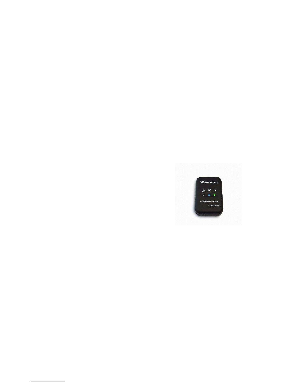
1 Product Overview
The GT30X is a GPS/GPRS based personal tracking device, which is compact and easy to use.
GT30X has inbuilt GPS module to obtain accurate position data and utilizes its GSM capability to send the
position data to a specified mobile phone or server base to allow users to monitor people or pets using the
tracker.
GT30X supports two way voice communications and can be activated either by the guardian calling the
tracker or the tracker holder activating the SOS button. The tracker can be configured to report its location
to the server base or mobile phone at preset intervals.
With internal memory , GT30X can store GPS coordinates when there is no GPRS connection or at a specified
interval requested by the user.
GT30X has the following functions:
Real time tracking via SMS or GPRS (TCP/UDP)
Track on demand
Show location directly on mobile phone
Track by time interval
Two-way audio
GSM blind area memory
Logging capacity up to 180,000 waypoints
Inbuilt motion sensor for power saving
SOS panic button
Movement alarm
Geo-fencing control
Low battery alarm
Overspeed alarm
GPS blind area alarm (in/out)
Three buttons for making phone call and/or sending message
Built-in super magnet (optional)
2 For Your Safety
Read these simple guidelines. Not following them may be dangerous or illegal. Read the full user manual for
more information.
Switch on safely Do not switch on GT30X w hen wireless phone use is prohibited or when it
may cause interference or danger.
Switch off in hospitals Follow any restrictions. Switch GT30X off near medical equipment.
Switch off in aircraft Follow any restrictions. Wireless devices can cause interference in aircraft.
Switch off when refueling Do not use GT30X when at a refueling point. Do not use near fuels or
WWW.GPS-TEKNIK.SE
WWW.GPS-TEKNIK.COM
SOFTWARE@GPS-TEKNIK.SE
FORUM - WWW.GPS-TEKNIK.EU
WWW.GPS-TEKNIK.SE
WWW.GPS-TEKNIK.EU
DEVELOPER@GPS-TEKNIK.SE
FORUM - WWW.GPS-TEKNIK.EU

chemicals.
Switch off near blasting Follow any restrictions. Do not use GT30X when blasting is in progress.
Qualified service Only qualified personnel can repair GT30X.
Water resistance
GT30X is not fully water
resistant. Keep it dry. Use waterproof bag if
necessary.
3 GT30X Characteristics
Items Specification
Charging Voltage DC 4.2-5.5V/400mA (Mini USB port)
Internal Battery Rechargeable and replaceable 1350 mAh battery (3.7V),
Dimension 77 mm × 51 mm × 25 mm
Weight 80g (with battery)
Operating temperature -20° to 55° C
Humidity 5% to 95% Non-condensing
GSM module Quad Band GSM 850/900/1800/1900Mhz
GPS Chipset latest GPS SIRF-Star III chipset
GPS Sensitivity -158Db
GPS Frequency L1, 1575.42 MHz
C/A Code 1.023 MHz chip rate
Channels 20 channel all-in-view tracking
Position Accuracy 10 meters, 2D RMS
Velocity Accuracy 0.1 m/s
Time Accuracy 1 us synchronized to GPS time
Default datum WGS-84
Reacquisition 0.1 sec., average
Hot start 1 sec., average
Warm start 38 sec., average
Cold start 42 sec., average
Altitude Limit 18,000 meters (60,000 feet) max.
Velocity Limit 515 meters/second (1000 knots) max.
Acceleration Limit Less than 4g
Jerk Limit 20 m/sec
Work time 55 hours in power-saving mode and 1 2 hours in normal mode
Memory 4MB flash memory
LED 3 LED lights to show power, GPS, GSM and other status.
Button 3 buttons(SOS/B/C) for making phone calls and sending SMS
4 Getting Started
This section will describe how to set up your GT30X.
4.1 Hardware and Accessories
GT30X is supplied in a box which includes:
WWW.GPS-TEKNIK.SE
WWW.GPS-TEKNIK.COM
SOFTWARE@GPS-TEKNIK.SE
FORUM - WWW.GPS-TEKNIK.EU
WWW.GPS-TEKNIK.SE
WWW.GPS-TEKNIK.EU
DEVELOPER@GPS-TEKNIK.SE
FORUM - WWW.GPS-TEKNIK.EU
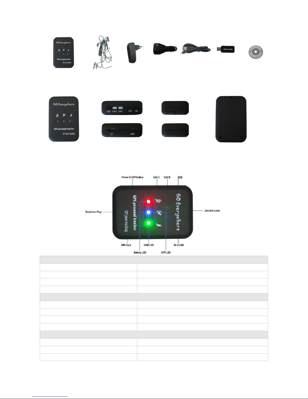
GT30X with Battery Earphone with Mic Wall Charger Car Charger USB Cable USB to Serial CD
4.2 View
Front View Side View Back View
4.3 Functional Parts
Your GT30X has four buttons and three LEDs with three different colors to indicate the status of the unit.
Red LED - indicating battery status
Off Power is off or charging is complete
Flashing (every 0.1 second) Low power
On Charging
Flashing (1 second on and 2 seconds off) Working
Blue LED - indicating GPS status
On One button is pressed
Flashing ( every 0.1 second) The unit is being Initialized
Flashing (0.1 second on and 2.9 seconds off) GT30X has a GPS fix
Flashing (1 second on and 2 seconds off) GT30X has no GPS fix
Green LED - indicating GSM status
On One call is coming in / one call is being made
Flashing ( every 0.1 second) The unit is being Initialized
Flashing (0.1 second on and 2.9 seconds off) GT30X is connected to the GSM network
WWW.GPS-TEKNIK.SE
WWW.GPS-TEKNIK.COM
SOFTWARE@GPS-TEKNIK.SE
FORUM - WWW.GPS-TEKNIK.EU
WWW.GPS-TEKNIK.SE
WWW.GPS-TEKNIK.EU
DEVELOPER@GPS-TEKNIK.SE
FORUM - WWW.GPS-TEKNIK.EU
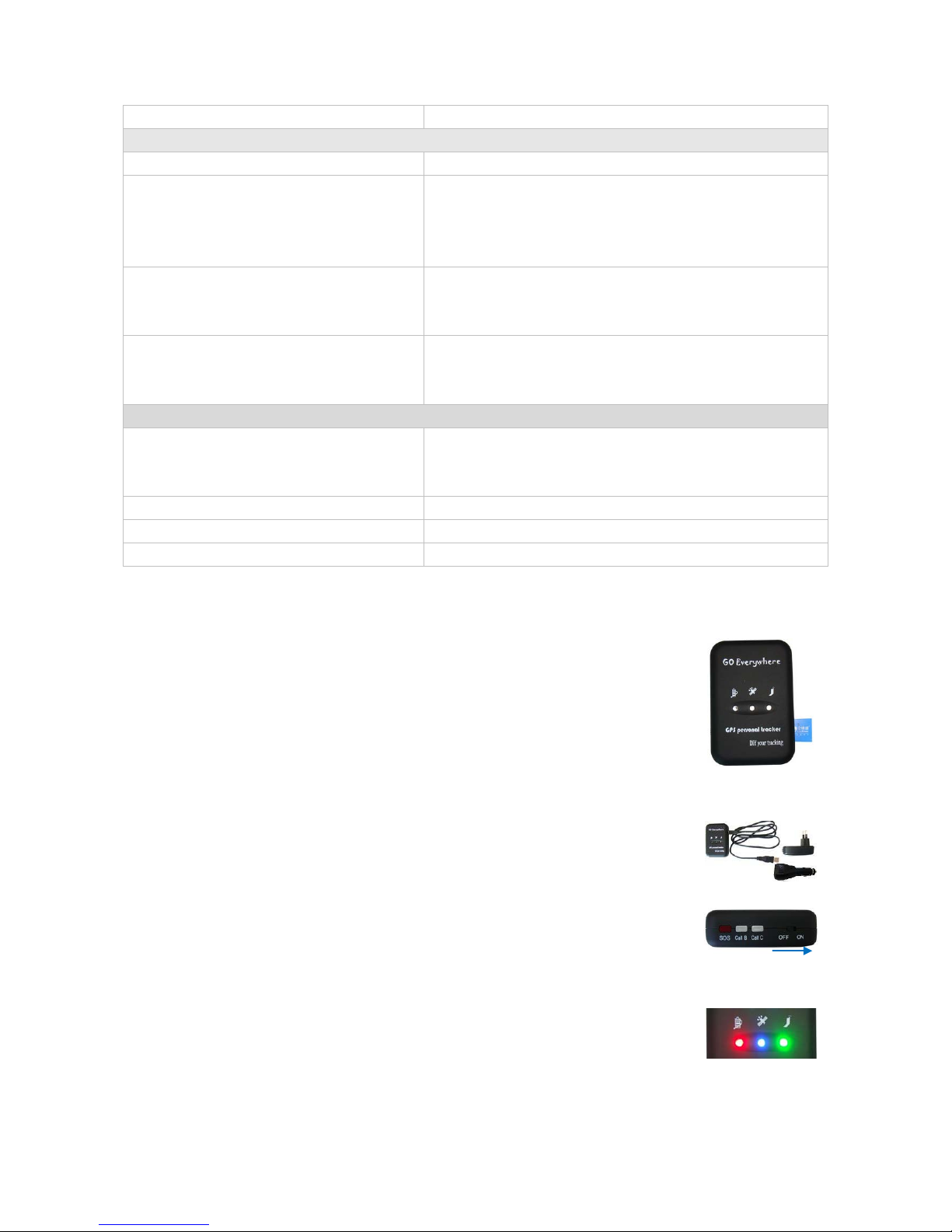
Flashing (1 second on and 2 seconds off) GT30X is not connected to the GSM network
Buttons
Power On/Off Button To turn on/off GT30X
SOS Button To make a phone call and/or send an SMS to the preauthorized phone
number.
Press it to receive an incoming call.
Press it to increase volume during conversation.
Call B To make a phone call and/or send an SMS to the preauthorized phone
number.
Press it to reject a call, cancel calling or complete a conversation.
Call C To make a phone call and/or send an SMS to the preauthorized phone
number.
Press it to decrease volume during conversation.
Other Connectors
Mini USB Used for charging, firmware update, configuration on PC and exporting
stored data. (USB to Serial Converter is required fo r firmware upd ate,
configuration and exporting stored data)
SIM Card To insert SIM card here
Earphone Plug For connecting earphone
Lanyard Loop For connecting lanyard.
4.4 First Use
Please read this manual before using your GT30X.
4.4.1 Ensure that your GT30X has a working SIM installed.
- Check that the SIM has not run out of credit (Test the SIM in a phone to make sure
it can send and receive SMS)
- Check that the SIM Lock code is turned off
- If you require the function of sending an SMS location report to the authorized
phone number when it makes a call to the GT30X, please make sure the SIM installed
supports displaying caller ID.
4.4.2 Charge the battery for at least 3 hours in power-off status using the wall
charger or car charger. Or you can connect the tracker directly to computer by USB.
Red light is on during charging and is off when charging is complete.
4.4.3 Push the Power On/Off button to the ON side and wait for about 20 seconds. It
will then enter standby mode. It is suggested that you be in an outer place where it
can receive better GPS when you turn on the device.
Check that the Red LED (Battery) is flashing 1 second on and 2 seconds off.
Check that the Green LED (GSM) is flashing 0.1 second on and 2.9 seconds off.
Check that the Blue LED (GPS) is flashing 0.1 second on and for 2.9 seconds off.
5. Change Password
WWW.GPS-TEKNIK.SE
WWW.GPS-TEKNIK.COM
SOFTWARE@GPS-TEKNIK.SE
FORUM - WWW.GPS-TEKNIK.EU
WWW.GPS-TEKNIK.SE
WWW.GPS-TEKNIK.EU
DEVELOPER@GPS-TEKNIK.SE
FORUM - WWW.GPS-TEKNIK.EU

Command: W******,001,######
Description: Changes user’s password.
Notes:
1. ****** is user’s password and the default password is 000000. The tracker will only accept commands
from a user with the correct password. Commands with wrong password will be ignored.
2. ###### is the new password. Password should be 6 digits.
Example:
W000000,001,123456
W123456,001,999999
6. Time Zone
Command: W******,032,T
Description: Corrects time into your local time
Notes:
1. Default time of the tracker is GMT
2. This correction is applied to location reports by SMS and SMS alarms.
T=0, to turn off this function.
T=[1, 65535] to set time difference in minute to GMT.
For those ahead of GMT, just input the time difference in minute directly. For example, GMT+8,
W000000,032,480
‘-‘is required for those behind GMT. For example, W000000,032,-120.
Example:
W000000,032,480
W000000,032,-120
7. Track
7.1 Track by SMS
- Track on Demand - Reply with longitude, latitude, speed and date
Command: W******,000
Description: Get the current location of the tracker, send this SMS or make a telephone call directly to the
tracker and it will report its longitude and latitude by SMS with format as follows:Latitude = 22 32 36.63N Longitude = 114 04 57.37E, Speed = 2.6854Km/h, 2008-12-24,01:50
Example:
W000000,000
- Track on Demand - Reply with a Google link
Command: W******,100
Description: Send this command to the tr acker and then you receive an SMS with an http link. Click on the
link then the location can be shown directly on Google Map on your mobile phone. For example:
Notes: Only smart phones and PDA support this function.
http://maps.google.com/maps?f=q&hl=en&q=22.540103,114.082329&ie=UTF8&z=16&iwloc=addr&om=1
WWW.GPS-TEKNIK.SE
WWW.GPS-TEKNIK.COM
SOFTWARE@GPS-TEKNIK.SE
FORUM - WWW.GPS-TEKNIK.EU
WWW.GPS-TEKNIK.SE
WWW.GPS-TEKNIK.EU
DEVELOPER@GPS-TEKNIK.SE
FORUM - WWW.GPS-TEKNIK.EU

Example:
W000000,100
7.2 Track by Calling
Make a missed call to the tracker and it will report its longitude and latitude by SMS with format as follows:Latitude = 22 32 36.63N Longitude = 114 04 57.37E, Speed = 2.6854Km/h, 2008-12-24,01:50
7.3 Track by Preset Interval
Command: W******,002,XXX
Description: Sets an interval for the tracker to continuously return its location by SMS
Notes:
1. XXX is the interval in minute.
2. If XXX=000 to turn off tracking by time
Example:
W000000,002,030
The tracker will send location data back to your mobile phone every 30 minutes.
7.4 Google Earth and Google Map
Download Google Earth from
http://earth.google.com/.
Start Google Earth (For more information about Google Earth please refer to
http://earth.google.com/) or
go to
http://maps.google.com
Input the latitude and longitude that you receive from the tracker by SMS and click the search button.
Google Earth or Google Maps will display the location for you.
in your Internet Explorer
Example:
When you receive: Latitude = 22 32 40.05N Longitude = 114 04 57.74E
Type as the following picture shows:
(Note: you should input the latitude and longitude as: 22 32 40.05N 114 04 57.74E)
And then you can find the location of your tracker:
WWW.GPS-TEKNIK.SE
WWW.GPS-TEKNIK.COM
SOFTWARE@GPS-TEKNIK.SE
FORUM - WWW.GPS-TEKNIK.EU
WWW.GPS-TEKNIK.SE
WWW.GPS-TEKNIK.EU
DEVELOPER@GPS-TEKNIK.SE
FORUM - WWW.GPS-TEKNIK.EU

Or you can use local map software on PDA or car navigation device to input the coordinates.
7.5 Track by MS01
If you have bought our GPRS tracking software MS01, after proper configuration, you can do tracking o n
MS01.
GPS Tracking System - MS01
Please refer to MS01 User Guide for more information.
7.6 Track by GPRS between Server and Trac k er
7.6.1 Set Tracker ID
Command: W******,010,ID
Description: Sets a digital ID for the tracker.
Notes:
Tracker ID must not over 14 digits.
Example:
W000000,010,00001
7.6.2 Set APN
Command: W******,011,APN,Username,Password
Description: Sets APN details for the tracker
Notes:
1. APN username and p assword are optional. If no APN username and password are required, just input APN
only;
2. APN defaulted as ‘CMNET’;
3. APN + username + password should not over 39 characters.
Example:
W000000,011,CMNET,xxxxx,6688
WWW.GPS-TEKNIK.SE
WWW.GPS-TEKNIK.COM
SOFTWARE@GPS-TEKNIK.SE
FORUM - WWW.GPS-TEKNIK.EU
WWW.GPS-TEKNIK.SE
WWW.GPS-TEKNIK.EU
DEVELOPER@GPS-TEKNIK.SE
FORUM - WWW.GPS-TEKNIK.EU

W000000,011,CMNET
7.6.3 Set IP and Port
Command: W******,012,IP,Port
Description: Sets IP and Port for tracker for GPRS communication.
Notes:
1. IP is your server’s IP or the domain name.
2. Port: [1,65534]
Example:
W000000,012, 220.121.7.89,8500
W000000,012,www.xxxxx.net,8500
7.6.4 Set DNS Server IP (optional)
Command: W******,009,DNS Server IP
Description: In case the domain name you set by the last command (W******,012,IP, Port) doesn’t work,
which means your server IP is not properly set. You can first use this command to set DNS Server IP (please
check with your DNS server provider for the DNS Server IP) and then redo the command W******,012,IP,
Port.
Example: W000000,009,220.23.4.90
7.6.5 Enable GPRS Tracking
Command: W******,013,X
Description: Enables GPRS tracking function.
Notes:
X=0, to turn off GPRS tracking (default);
X=1, to enable GPRS tracking via TCP
X=2, to enable GPRS tracking via UDP
Example: W000000,013,1
7.6.6 Set GPRS Interval
Command: W******,014,XXXXX
Description: Sets time interval for sending GPRS packets.
Notes:
XXXXX should be in five digits and in unit of 10 seconds.
XXXXX=00000, to turn off this function;
XXXXX=00001~65535, time interval for sending GPRS packet and in unit of 10 seconds.
In this example, the tracker will send every 600 seconds (10 minutes).
Example: W000000,014,00060
The tracker will send every 600 seconds (10 minutes).
For more information regarding G PRS tracking please refer to <GPRS Communic ation Protocol>
WWW.GPS-TEKNIK.SE
WWW.GPS-TEKNIK.COM
SOFTWARE@GPS-TEKNIK.SE
FORUM - WWW.GPS-TEKNIK.EU
WWW.GPS-TEKNIK.SE
WWW.GPS-TEKNIK.EU
DEVELOPER@GPS-TEKNIK.SE
FORUM - WWW.GPS-TEKNIK.EU

8. Authorization
Command: W******,003,F,P,T1 or W******,003,F,P,T1,T2 (optional)
Description: Authorizes phone numbers for the buttons/inputs for receiving location reports or SMS alarms
or phone calls
Notes:
F=0, to turn off this function; (default)
F=1, only sends SMS to the authorized phone number;
F=2, only calls the authorized phone number;
F=3, both SMS and calling
P=1, set an authorized number for SOS button (Input 1)
P=2, set an authorized number for B button (Input 2)
P=3, set an authorized number for C button (Input 3)
T1: Preset phone number. Max.16 digits
If you need to set different numbers for receiving SMS and phone call, you can then use
W******,003,F,P,T1,T2, In this case T1 is the phone number for receiving SMS and T2 for receiving phone
call.
Example:
W000000,003,3,1,88888888
W000000,003,3,1,88888888,99999999
9. Call Function
You can use the earphone for conversation purpose.
9.1 Receiving Phone Call
Use your phone or mobile phone to call the tracker, the green LED will be on. Press SOS button to receive the
incoming call or press Call B button to reject the call.
9.2 Making Phone Call
After you have authorized phone numbers for SOS/Call B/Call C button, you can press one of these buttons
to make a call to the preset phone number.
Press Call B button to cancel a calling or to end a conversation.
9.3 Volume Adjustment
During a conversation, press SOS button to increase the volume or press Call C button to decrease the
volume.
10. Low Power
Command: W******,004,X
Description: When the tracker’s voltage is lower than the preset value, it will send an SMS alarm to the
authorized phone number for SOS.
Notes: X is the preset value of voltage.
WWW.GPS-TEKNIK.SE
WWW.GPS-TEKNIK.COM
SOFTWARE@GPS-TEKNIK.SE
FORUM - WWW.GPS-TEKNIK.EU
WWW.GPS-TEKNIK.SE
WWW.GPS-TEKNIK.EU
DEVELOPER@GPS-TEKNIK.SE
FORUM - WWW.GPS-TEKNIK.EU

=0 , to turn off this function =1, <3.3V =2 , <3.4V
=3 , <3.5V (default) =4 , <3.6V =5 , <3.7V
Example: W000000,004,2
11. Overspeed
Command: W******,005,XX
Description: T urns on overspeed alarm. When the tracker speeds higher than the preset value, it will send
an SMS to the phone number for SOS.
Notes: XX is the preset value of speed and in 2 digits.
=00 , to turn off this function
=[01, 20] (unit: 10Km/h)
Example: W000000,005,08
When the tracker’s speed is over 80km/h, an SMS alarm will be sent out.
12. Movement/Geofence
12.1 Movement Alarm
Command: W******,006,XX
Description: When the tracker moves out of a preset square scope, it will send an SMS alarm to the
authorized phone number for SOS.
Notes:
XX is the preset distance to the tracker’s original place
=00, to turn off this function
=01, 30m =02, 50m =03, 100m =04, 200m
=05, 300m =06, 500m =07, 1000m =08, 2000m
Example: W000000,006,06
When tracker moves out of this square scope, it will send out an SMS alarm.
12.2 Geo-fence Alarm
Command: W******,017,X or W******,117,X
Description: T urns on Geo-fencing a larm. When the tr acker move s in/out the preset scope, it will send an
SMS alarm to the authorized phone number for SOS.
Notes:
1. 017 is for alarm when tracker moves out the preset scope;
2. 117 is for alarm when tracker moves in.
3. X is the coordinates which include: Lower-left X,Lower-left Y,Upper-right X,Upper-right Y
4. Lower-left X should be less than Upper-right X;
5. All longitudes and latitudes should be in ASCII format as follows:-
WWW.GPS-TEKNIK.SE
WWW.GPS-TEKNIK.COM
SOFTWARE@GPS-TEKNIK.SE
FORUM - WWW.GPS-TEKNIK.EU
WWW.GPS-TEKNIK.SE
WWW.GPS-TEKNIK.EU
DEVELOPER@GPS-TEKNIK.SE
FORUM - WWW.GPS-TEKNIK.EU

Longitude: DDDFF.FFFF,E/W. 4 places of decimal. ‘0’ is needed to be stuffed if no value available.
Latitude: DDFF.FFFF,N/S. 4 places of decimal. ‘0’ is needed to be stuffed if no value available;
6. Send W******,006,00 to turn off Geo-fence function.
Example:
W000000,017,11404.0000,E,2232.0010,N,11505.1234,E,2333.5678,N
W000000,117,11404.0000,E,2232.0010,N,11505.1234,E,2333.5678,N
Remarks:
1. Only one alarm can be set in either In or Out;
2. Only one alarm can be set in either Movement Alarm or Geo-fence Alarm.
13. Track Log
13.1 Log by Interval
Command: W******,031,X
Description: S ets time interval for logging GPS information. The information is stored within the device
memory . When the memory get s full, the newest record will be overwritten on top of the oldest (FIFO - First
In, First Out). In that case, only the newest information is stored.
Note:
1. X=0, to turn off this function. X=[1, 65535] to set interval in the unit of SECOND.
2. The logged message is in GPRMC format and includes:
Date and time
Longitude
Latitude
Speed
Direction
3. All data, stored within the memory, may be exported to the PC using the USB connector. For this matter
the “GPSLog” program has to be used (please refer to < GPSLog User Guide> and <GPRS Communication
Protocol> for more information).
4. The device has 4MB internal memory space for storing the track log and is able to store up to 180,000
records within the memory.
Example:
W000000,031,60
The tracker will store GPS data every 60 seconds.
13.2 Auto Log when no GPRS
When there is no GPRS connection, the tracker can store all GPS information tr iggered by preset tracking
interval, alarms, request, or button activation and send this information (FIFO - First In, First Out) to server
by GPRS or preauthorized mobile phone by SMS when GPRS connection recovers.
The interval memory can store up to 1500 SMS and 4600 GPRS message.
14. Power Down
Command: W******,026,XX
WWW.GPS-TEKNIK.SE
WWW.GPS-TEKNIK.COM
SOFTWARE@GPS-TEKNIK.SE
FORUM - WWW.GPS-TEKNIK.EU
WWW.GPS-TEKNIK.SE
WWW.GPS-TEKNIK.EU
DEVELOPER@GPS-TEKNIK.SE
FORUM - WWW.GPS-TEKNIK.EU

Description: Makes the tracker into power down mode when it is inactive or immobile for a period of time.
In Power Down states, GPS stops w orking an d GSM enters sleep and stop sending out message until it is
activated by message, incoming calls or movement or triggered by three buttons.
Notes:
XX=00, to turn off this function.
XX=01~99, to turn on Power Down after a specified period of being inactive (or stationary). It is in unit of
minute.
Example: W000000,026,10
The tracker will enter power down mode after it is inactive (or stationary) for 10 minutes.
15. Initialization
Command: W******,990,099###
Description: This is to make all settings (except for the password) back to factory default.
Notes:
Turn on the device, press the S OS button f or five times conti nuousl y and the r ed LED w ill be on, and the n
send (within 120 seconds) this SMS to the tracker.
### is the ending character and is required in the text message.
Example: W000000,990,099###
16. Password Initialization
Command: W888888,999,666
Description: This is to make the password back to factory default in case you forget your password.
Notes: turn on the tr acker, press the SOS button for five times continuously and the red LED will be on, and
then send this SMS (within 120 seconds) to the tracker to make the password back to factory default
(000000).
Example: W888888,999,666
For more details regarding SMS commands, please go to Annex 1 Command List in page
17. Parameter Editor
The tracker can be configured by computer using the Parameter Editor.
GPS Tracker Parameter Editor V1.39
Please refer to <GPS Tracker Parameter Editor> for more information.
WWW.GPS-TEKNIK.SE
WWW.GPS-TEKNIK.COM
SOFTWARE@GPS-TEKNIK.SE
FORUM - WWW.GPS-TEKNIK.EU
WWW.GPS-TEKNIK.SE
WWW.GPS-TEKNIK.EU
DEVELOPER@GPS-TEKNIK.SE
FORUM - WWW.GPS-TEKNIK.EU

Annex 1. SMS Command List
Note: ****** is user’s password and the default password is 000000. The tracker will only accept
commands from a user with the correct password. Commands with wrong password will be ignored.
Description SMS Co m m and Example
Track on Demand W******,000 W000000,000
Remarks: To get the current locat ion of the tracker, send this SMS or make a telephone call directly to the tracker and it will
report its longitude and latitude by SMS with format as follows:Latitude = 22 32 36.63N Longitude = 114 04 57.37E, Speed = 2.6854Km/h, 2008-12-24,01:50
Track on Demand
-Google Link
W******,100 W000000,100
Remarks: Send this command to the tracker and then you receive an SMS with an http link. Click on the link then the location
can be shown directly on Google Map on your mobile phone. For example:
(Note: Only smart phones and PDA support this function.)
http://maps.google.com/maps?f=q&hl=en&q=22.540103,114.082329&ie=UTF8&z=16&iwloc=addr&om=1
Change Password W******,001,###### W000000,001,123456
Remarks: To change user’s password. ###### is the new password. Password should be 6 digits.
Track by Interval W******,002,XXX W000000,002,030
Remarks: To set interval for automatic timed report.
XXX is the interval in minute. If XXX=000 to turn off tracking by time.
In this example, the tracker will send location data back to your mobile phone every 30 minutes.
Authorize Phone Number for
SOS, B and C button
W******,003,F,P,T1
(W******,003,F,P,T1,T2)
W000000,003,3,1,88888888
W000000,003,3,1,88888888,99999999
Remarks: To authorize phone numbers for the buttons/inputs for receiving location reports or SMS alarms or phone calls.
F=0, to turn off this function; (default)
F=1, only sends SMS to the authorized phone number;
F=2, only calls the authorized phone number;
F=3, both SMS and calling
P=1, set an authorized number for SOS button (Input 1)
P=2, set an authorized number for B button (Input 2)
P=3, set an authorized number for C button (Input 3)
T1: Preset phone number. Max.16 digits
If you need to set different numbers for receiving SMS and phone call, you can then use W******,003,F,P,T1,T2, In this case
T1 is the phone number for receiving SMS and T2 for receiving phone call.
Low Power Alarm W******,004,X W000000,004,2
Remarks: When the tracker’s voltage is lower than the preset value, it will send an SMS alarm to the authorized phone number
for SOS.
X is the preset value of voltage.
=0 , to turn off this function =1, <3.3V =2 , <3.4V
WWW.GPS-TEKNIK.SE
WWW.GPS-TEKNIK.COM
SOFTWARE@GPS-TEKNIK.SE
FORUM - WWW.GPS-TEKNIK.EU
WWW.GPS-TEKNIK.SE
WWW.GPS-TEKNIK.EU
DEVELOPER@GPS-TEKNIK.SE
FORUM - WWW.GPS-TEKNIK.EU

=3 , <3.5V (default) =4 , <3.6V =5 , <3.7V
Overspeed Alarm W******,005,XX W000000,005,08
Remarks: When the tracker speeds higher than the preset value, it will send an SMS to the phone number for SOS.
XX is the preset value of speed and in 2 digits.
=00 , to turn off this function
=[01, 20] (unit: 10Km/h)
In this example, when the tracker’s speed is over 80km/h, an SMS alarm will be sent out.
Movement Alarm W******,006,XX W000000,006,06
Remarks: When the tracker moves out of a preset square scope, it will send an SMS alarm to the authorized phone number for
SOS.
XX is the preset distance to the tracker’s original place
=00, to turn off this function
=01, 30m =02, 50m =03, 100m =04, 200m
=05, 300m =06, 500m =07, 1000m =08, 2000m
Geo-fence Alarm W******,017,X
W******,117,X
W000000,017,11404.0000,E,2232.0010,N,11505.12
34,E,2333.5678,N
W000000,117,11404.0000,E,2232.0010,N,11505.12
34,E,2333.5678,N
Remarks: 017 is for alarm when tracker moves out the preset scope; 117 is for alarm when tracker moves in.
When the tracker moves in or out, it will send an SMS alarm to the authorized phone number for SOS.
X is the coordinates which include:
Lower-left X,Lower-left Y,Upper-right X,Upper-right Y
For example, 11404.0000,E,2232.0010,N,11505.1234,E,2333.5678,N
Note:
1. Lower-left X should be less than Upper-right X;
2. All longitudes and latitudes should be in ASCII format as follows:-
Longitude: DDDFF.FFFF,E/W. 4 places of decimal. ‘0’ is needed to be stuffed if no value available.
Latitude: DDFF.FFFF,N/S. 4 places of decimal. ‘0’ is needed to be stuffed if no value available;
3. Only one alarm can be set in either Movement Alarm or Geo-fence Alarm;
4. Send W******,006,00 to turn off Geo-fence function.
Extended Functions W******,008,ABCDEFGHIJ### W000000,008,1011100011###
Remarks:
A=0, turn off the function of sending SMS position report after a phone call is made to the tracker.
A=1, turn on the function of sending SMS position report after a phone call is made to the tracker.
B=0, location data of NMEA 0183 GPRMC will be interpreted into normal text for easy reading.
For example, Longitude = 114 degree - 04 minute -57.74 second, Latitude = 22 degree -32 minute -40.05 second
B=1, location data complies with NMEA 0183 GPRMC protocol.
For example, $GPRMC,161509.000,A,2232.5485,N,11404.6887,E,0.3,153.7,290709,,*03
C=0, turn off the function to automatically hang up an incoming call.
WWW.GPS-TEKNIK.SE
WWW.GPS-TEKNIK.COM
SOFTWARE@GPS-TEKNIK.SE
FORUM - WWW.GPS-TEKNIK.EU
WWW.GPS-TEKNIK.SE
WWW.GPS-TEKNIK.EU
DEVELOPER@GPS-TEKNIK.SE
FORUM - WWW.GPS-TEKNIK.EU

C=1, turn on the function to automatically hang up an incoming call after 4 - 5 rings.
D=0, Turn off the function of sending an SMS when the tracker is turned on.
D=1, Turn on the function of sending an SMS to SOS number when the tracker is turned on.
E, defaulted as 1 (the tracker shuts down automatically when the power voltage is lower than 3V).
F=0, Turn off the SMS alarm when the tracker enters GPS blind area.
F=1, Turn on the SMS alarm when the tracker enters GPS blind area. SMS is to be sent to the authorized phone number for
SOS.
G=0, 3 LEDs work normally.
G=1, 3 LEDs stop flashing when the tracker is working.
H, reserved and defaulted as ‘0’
I, reserved and defaulted as ‘0’
J, reserved and defaulted as ‘1’
### is the ending character
(ABCDEFGHIJ defaulted as 1000100001)
Presetting by SMS for GPRS tracking (Ensure that your SIM card supports GPRS connection prior to setting)
Set Tracker ID W******,010,ID W000000,010,00001
Remarks: to set a digital ID for the tracker.
Tracker ID must not over 14 digits.
Set APN W******,011,APN,Username,
Password
W000000,011,CMNET, xxxxx,6688
W000000,011,CMNET
Remarks: If no APN username and password are required, just input APN only;
APN defaulted as ‘CMNET’;
APN + username + password should not over 39 characters.
Set IP and Port W******,012,IP,Port W000000,012, 220.121.7.89,8 500
W000000,012,www.xxxxx.net,8500
Remarks: IP is your server’s IP or the domain name. Port: [1,65534]
Set DNS Server IP W******,009,DNS Server IP W000000,009,220.23.4.90
Remarks: In case the domain name you set by the last command (W******,012,IP, Port) doesn’t work, which means your
server IP is not properly set. You can first use this command to set DNS Server IP (please check with your DNS server provider
for the DNS Server IP) and then redo the command W******,012,IP, Port.
Enable GPRS Tracking W******,013,X W000000,013,1
Remarks:
X=0, to turn off GPRS tracking (default);
X=1, to enable GPRS tracking via TCP
X=2, to enable GPRS tracking via UDP
Set GPRS Interval W******,014,XXXXX W000000,014,00060
Remarks: to set time interval for sending GPRS packets.
XXXXX should be in five digits and in unit of 10 seconds.
WWW.GPS-TEKNIK.SE
WWW.GPS-TEKNIK.COM
SOFTWARE@GPS-TEKNIK.SE
FORUM - WWW.GPS-TEKNIK.EU
WWW.GPS-TEKNIK.SE
WWW.GPS-TEKNIK.EU
DEVELOPER@GPS-TEKNIK.SE
FORUM - WWW.GPS-TEKNIK.EU

XXXXX=00000, to turn off this function;
XXXXX=00001~65535, time interval for sending GPRS packet and in unit of 10 seconds.
In this example, the tracker will send every 600 seconds (10 minutes).
For more information regarding GPRS tracking please refer to <GPRS Communication Protocol>
Sleep Mode W******,021,XX### W000000,021,02###
Remarks: this setting is for power saving.
XX=00 turn off sleep mode XX=01 Level I XX=02 Level II
### is the ending character
Here is some explanation for the sleep mode. First, assume that the GPS acquisition time is ONE minute.
[1] In Level I
The GPS module will be working for the first three minutes (i.e. 3 times of acquisition time) and then shut down for ONE minute
(i.e. equivalent to acquisition time), and then work again for another three minutes……
[2] In Level II
The GPS module will be working for the first two minutes (i.e. twice of acquisition time) and then shut down for ONE minute (i.e.
equivalent to acquisition time), and then work again for another two minutes……
Power Down W******,026,XX W000000,026,10
Remarks: to set power down mode when the tracker is inactive or stationary for a period of time.
In Power Down mode, GPS stops working and GSM enters sleep and stop sending out message until it is activated by message,
incoming calls, movement, or triggered by three buttons.
XX=00, to turn off this function.
XX=01~99, to turn on Power Down after a specified period of being inactive (or stationary). It is in unit of minute.
In this example, the tracker will enter power down mode after it is inactive (or stationary) for 10 minutes.
Listen (Wiretapping) W******,030,T W000000,030,88888888
Remarks: T is the telephone number for wiretapping and max. 16 digits.
This is an optional function which requires an external microphone.
Set Logging Interval W******,031,X W000000,031,60
Remarks: to set the interval for storing GPS data into tracker’s flash memory.
(Note: this interval is not relevant to the interval of SMS/GPRS tracking)
X=0, to turn off this function.
X=[1, 65535] to set interval in second.
In this example of W000000,031,60, the tracker will store location data every 60 seconds.
Correct Time Difference W******,032,T W000000,032 ,480 W000000,032,-120
Remarks: Default time of the tracker is GMT, you can use this comment to correct it to your local time. This command is for SMS
tracking only.
T=0, to turn off this function.
T=[1, 65535] to set time difference in minute to GMT.
For those ahead of GMT, just input the time difference in minute directly. For example, GMT+8, W000000,032,480
‘-‘is required for those behind GMT. For example, W000000,032,-120.
WWW.GPS-TEKNIK.SE
WWW.GPS-TEKNIK.COM
SOFTWARE@GPS-TEKNIK.SE
FORUM - WWW.GPS-TEKNIK.EU
WWW.GPS-TEKNIK.SE
WWW.GPS-TEKNIK.EU
DEVELOPER@GPS-TEKNIK.SE
FORUM - WWW.GPS-TEKNIK.EU

Set SMS Initials W******,033,P,Char W000000,033,1,help
Remarks: this command is to set initial characters for SOS message when SOS/IN1, Button B/IN2, Button C/IN3 is pressed.
P=1, SOS button/Input1 P=2, B button/Input2 P=3, C button/Input3
Char is the character in SOS message and max 32 characters and defaulted as:
1 SOS Alarm! 2 Cry For Help! 3 Call The Police!
Set Prefix (Country Code) W******,502,*Data# W000000,502,*+86#
Remarks: be advised caution in this setting. Normally, your country code (for example in China it is +86) will be automatically
added and displayed prior to a phone number when sending SMS. In this case, you don’t have to do this setting. If the country
code is not added, you are required to input the country code, for example, +86, to enable the tracker can send out SMS to your
mobile phone.
Data: max 10 digits
Get Version No. and Serial No. W******,600 W000000,600
Remarks: to get the version and serial number of tracker’s firmware
Get IMEI W******,601 W000000,601
Remarks: to get IMEI of the tracker
Reboot GSM W******,901### W000000,901###
Remarks: to reboot the GSM module of the tracker
Reboot GPS W******,902### W000000,902###
Remarks: to reboot the GPS module of the tracker
Initialization W******,990,099### W000000,990,099###
Remarks: T urn on the device, press the SOS button for five times continuously and the red LED will be on, and then send (within
120 seconds) this SMS to the tracker to make all settings (except for the password) back to factory default.
### is the ending character.
Password Initialization W888888,999,666 W888888,999,666
Remarks: In case you forget your password, turn on the tracker, press the SOS button for five times continuously and the red
LED will be on, and then send this SMS (within 120 seconds) to the tracker to make the password back to factory default
(000000).
Annex 2. Troubleshooting
Problem: Unit will not turn on when pushing the power switch to On side
Possible Cause: Resolution:
Power switch was not pushed properly Check and make sure the power button is pushed to On side.
Battery needs charging Recharge battery for 3 hours
Problem: Unit will not reply with SMS
Possible Cause: Resolution:
WWW.GPS-TEKNIK.SE
WWW.GPS-TEKNIK.COM
SOFTWARE@GPS-TEKNIK.SE
FORUM - WWW.GPS-TEKNIK.EU
WWW.GPS-TEKNIK.SE
WWW.GPS-TEKNIK.EU
DEVELOPER@GPS-TEKNIK.SE
FORUM - WWW.GPS-TEKNIK.EU

Green LED is flashing (1 second on and 2
seconds off)
Make GT30X connected to GSM network.
GSM Network is slow Wait for SMS. Som e GSM networks slow down during peak time or when
they have equipment problems.
Unit is sleeping Cancel sleeping mode
Wrong password in your SMS or wrong SMS
format
Write correct password or SMS format
The SIM in GT30X has run out of credit Replace or top up the SIM card
Problem: Green LED is Flashing (1 second on and 2 seconds off)
Possible Cause: Resolution:
No GSM signal Check with a mobile phone to see if there is a signal in the area or try to call
the unit to see if you hear a ring tone.
No SIM card Insert a working SIM card. Check in phone that the SIM can send SMS
message.
SIM card has expired Check in phone that the SIM can send SMS message. Replace SIM card if
needed.
SIM has PIN code set Remove PIN code by inserting SIM in you phone and deleting the code.
SIM is warped or damaged Inspect SIM, clean the contacts. If re-inserting does not help try another to
see if it will work.
Roaming not enabled If you are in a different country your SIM account must have roaming
enabled.
Battery is low Recharge the unit and the GSM will start working.
Problem: Blue LED is Flashing (1 second on and 2 seconds off) or the SMS received starts with ‘Last…’
Possible Cause: Resolution:
Unit does not have clear view of the sky Move the unit to a location where the sky is visib le. Tall buildings, trees,
heavy rain, can cause problems with the GPS reception.
Bad GPS reception Place the front side of GT30X towards sky
Battery is low Recharge the unit and the GPS will start working.
Problem: Unit Fails to Connect to Server via GPRS
Possible Cause:
Resolution:
SIM card in GT30X does not support GPRS
function
Enable SIM card GPRS function.
GPRS function of GT30X is turned off Turn on GPRS function of GT30X.
Incorrect IP address or PORT Get the right IP address and PORT and reset to GT30X.
GSM signal is weak Move the unit to a location with good GSM reception.
WWW.GPS-TEKNIK.SE
WWW.GPS-TEKNIK.COM
SOFTWARE@GPS-TEKNIK.SE
FORUM - WWW.GPS-TEKNIK.EU
WWW.GPS-TEKNIK.SE
WWW.GPS-TEKNIK.EU
DEVELOPER@GPS-TEKNIK.SE
FORUM - WWW.GPS-TEKNIK.EU
 Loading...