

Page 1
USB GPS User’s Guide V2.3 (WIN)
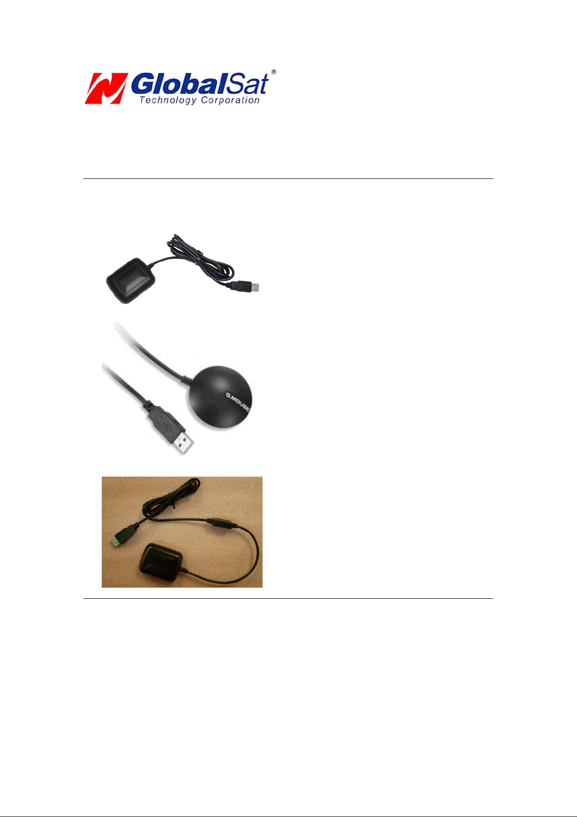
USB GPS Receiver
BU-303 (SiRF II)
BU-353(SiRF III)
BU-333N (SiRF III)
(Information on installation of the USB driver contained in this document is also applicable to our USB
cable set #BR305-USB)
Page 2

DOCUMENT REVISIONS
REV NO. DATE DESCRIPTION A PPROVED
1.2 02-28-2003 Initial document BRF
2.0 06-08-2005 New document format NRG
2.1 04-07-2006 Revision of embedded web links AAK
2.2 31-10-2007 Add USB for Vista Driver install explain LLE
2.3 03-12-2008 Add BU-333N Model LEE
© 2006 Globalsat Technology Corporation/USGlobalsat, Inc. All rights reserved. The Globalsat logo is a trademark
of Globalsat Corporation. Windows is a register trademark of Microsoft Corporation. Acrobat is a registered
trademark of Adobe Systems Incorporated. Mac is a registered trademark of the Apple Corporation. All ot her
trademarks or registered trademarks are acknowledged as the exclusive property of their respective owners.
All rights reserved. No part of this manual may be reproduced, transmitted, copi ed, or stored in any storage medium,
for any purpose, without prior written consent from Globalsat Technology Corporation or USGlobalsat, Inc.
Globalsat/USGlobalsat hereby grants the right to download one (1) copy of this manual onto a hard drive for
personal use. This manual is copyrighted and may contain proprietary information that is subject to change without
notice.
Page 3

USB GPS (WIN)
Table of Contents
PACKAGE CONTENTS................................................................. ................. ................ ..3
SYSTEM REQUIREMENTS...................................................................................... .......3
WELCOME...................................................................................... ................. ................ . .3
1. GETTING STARTED............................................................ ...................... ..................3
2. INSTALLING THE USB DRIVER TO YOUR LAPTOP...............................................5
3. COM PORT VERIFICATION..................................................... ................. ................ ..6
4. INITIALIZING YOUR GPS RECEIVER.......... ................ ...................... ................. .......6
5. USING / TESTING YOUR GPS RECEIVER...............................................................7
6. UN-INSTALL THE USB DRIVER.................................................................................8
7. FAQ’s.......................................................................................... ................. ........... ..... ..8
8. CONTACT INFORMATION............................................ ................. ................ .............9
9. SAFETY AND LEGAL NOTICES...............................................................................10
10. LIMITED WARRANTY..............................................................................................11
11. BU-303 SPECIFICATIONS......................................................................................12
12. BU-353/333N SPECIFICATIONS...................................... ...................... ................13
PAGE 2 OF 13
BU303-353_WIN_UsersGuide_ v2.3
Page 4

USB GPS (WIN)
P A CKAGE CONTENTS
- USB GPS Receiver
- Driver CD-ROM with User’s Guide and test utility for WIN and Mac O/S*
• WIN
Users ple ase refer to the root directory on the included CD-ROM for installation instructions
and drivers.
NOTE: Your can also download WIN driver and Installation Guides at: www.usglobalsat.com/
SYSTEM REQUIREMENTS
The Globalsat USB GPS receivers requires a Windows, or Macintosh la ptop computer, with a CDROM*, USB port, and NMEA compatible navigation software. The 3
software may have its own system requirements, please check with software vendor for details.
*CD-ROM is required for USB driver installation and access to the User’s Guide. If no CD-ROM drive is available,
files can be downloaded from the Internet at
: http://www.usglobalsat.com/
rd
party mapping/navigation
WELCOME
Thank you for purchasing a Globalsat USB GPS receiver! Globalsat USB GPS receivers allow for real-time street
navigation by using your laptop for graphical plotting and positioning of your route. Simply load the GPS driver, plug
the GPS receiver into your computer’s USB port and install your own personal mapping software to begin to view
your position in real-time in relation to the surrounding streets in your travel area.
You’ll find that almost any NMEA compliant mapping/charting software will be compatible with your USB GPS
receiver. Visit our web-site for recommended mapping programs that you can use.
http://www.usglobalsat.com/faq_details/Mapchart.asp
1. GETTING STARTED
These are only a few simple steps that you need to follow before usin g your USB GPS receive r:
• Install the USB driver and onto your laptop from the included CD-ROM or download the files from our web-site
www.usglobalsat.com
• Plug-in the GPS receiver into your laptop.
NOTE:
PAGE 3 OF 13
BU303-353_WIN_UsersGuide_ v2.3
Page 5

USB GPS (WIN)
From within your mapping, or navigatio n softwa re (including the supplied GPS Info rmation utility), you
will need to manually configure the selection of the COM port to what was as signed to the GPS
receiver so that proper communication between the GPS receiver and mapping program can occur.
Most all software requires that you manually configure the COM port setting for any GPS device you
use.
IMPORTANT:
1. You must change the default rate setting of your mapping software ‘s Baud Rate to 4800 if this is not currently
set as such otherwise GPS data cannot be received.
2. Set Baud Rate 4800, Data Bit: 8, Parity: None, Stop Bit: 1, Flow Control: None
PAGE 4 OF 13
BU303-353_WIN_UsersGuide_ v2.3
Page 6

USB GPS (WIN)
2. INST ALLING THE USB DRIVER T O Y OUR LAPT OP
1. Place the product CD-ROM into your CD-ROM drive.
2. Auto-run should detect the CD bring up the following screen below.
3. Click on the button t itled “USB Driver For XP” or ‘’USB Driver For Vista’’ from the main scre en as
shown above.
4. Or should your “Auto-Run” be disabled on your PC, use Windows Explorer or File Manager to
locate the file ti tled ”PL-2303 Driver Installer.exe” and “PL-2303 Vista Driver Installer.exe” in
the \WIN\USB Driver\ directory of the CD-ROM and click to launch the install process.
5. You will see two files.
6. If your Windows is Vista version, please double click on “PL-2303 Vista Driver
Installer.exe” to begin installation. Follow the instruction to complete the installation
process.
7. If your Windows is XP or 2000 version, please double click on “PL-2303 Driver Installer.exe” to
begin installation. Follow the instruction to complete the installation process.
PAGE 5 OF 13
BU303-353_WIN_UsersGuide_ v2.3
Page 7

USB GPS (WIN)
3. COM PORT VERIFICA TION
1. Once your USB Driver has been installed, you will need to confirm w hich COM Port your PC
has assigned to it in order to properly configu re any software that w ill be utilizing the GPS data
being received.
2. Your USB GPS MUST be plugged into your US B port at this time.
3. Using Window’s Control Panel, select System > Hardware > Device Manager
4. Then look under the heading of: PORTS (Com & LPT)
5. There should be a listing for: Prolific Serial-to-USB Comm Port (COM x)
(“x” will actually be the number your PC has assigned the USB GPS receiver).
6. Once you have identified the COM port number, any software that you utilize must be
configured to read GPS data from this COM port.
We strongly suggest that you first test your USB GPS with the included GPS Info utility program to
confirm that the GPS receiver if functioning properly on your PC and that you have successfully
configured the right COM Port setting. Once this has been done, close the GPS Info program and
start your application f or COM port conf igurati on.
NOTE: By default, your PC will not allow you to run multiple applications from a single COM port. It
is important that you close any previously opened GPS application before switching to another
GPS application as the GPS receiver and data will not be found by the new program.
There are special utilities available to split data into multiple COM ports for use by more than one
application simultaneously. (see: http://franson.com/gpsgate/
)
4. INITIALIZING Y OUR GPS RECEIVER
Before using your USB GPS receiver for navigation (especially for the first time), the receiver must
obtain a local GPS fix (coordinates) of the current position. To do this, take your laptop (with your USB
driver and the mapping software loaded and configured) to an open area that has a clear view to t he
sky (such as a park or empty field). Start your software (or the included GPS Info utility program) and
wait for initialization of the GPS to complete. This may take a few minutes depending on various
factors such as the distance of the current coordinates from the last time the GPS receiver was
activated, GPS signal strength and surrounding terrain (tall trees and buildings can block the satellite
signals). Once the RAW GPS data is displayed onto the screen, if applicable for your software, a fix has
been initialized (red LED on the GPS will also start to flash). In some cases initialization can take up to
several minutes depending on the conditions mentioned above before complete GPS data will be
displayed on the screen.
Coordinates scrolling with zero’s means that the port connection is complete, but the satellite data is not
being received yet (possibly still initializing or in a bad area for satellite reception).
PAGE 6 OF 13
BU303-353_WIN_UsersGuide_ v2.3
Page 8

USB GPS (WIN)
5. USING / TESTING Y OUR GPS RECEIVER
Once the USB GPS receiver’s driver and your personal mapping software have been installed and
configured properly, you can begin to use your navigation system b y plugging the USB GPS into yo ur
laptop’s USB port and launching your mapping software. If you don’t have a mapping, or navigation
software, we’ve included a GPS test utility called “GPS Info” for the purpose of confirming your
installation and configuration. This utility can be installed by clicking the GPSInfo.exe file from the Win
directory on the CD-ROM or downloaded from our web-site www.usglobalsat.com
LED Status indicator on the USB GPS”
LED OFF: GPS receiver is off (no power).
LED ON (solid): No fix, searching for GPS signals.
LED FLASHING: Position fix established and GPS signals are being received.
Always select an area in the vehicle where the GPS unit will be secure and not obstruct normal driving,
visibility and safety, but still maintaining a “view to the sky” in order to receive satellite data.
It is recommended that you first load and test your GPS receiver with the GPSinfo.exe. This process
will confirm you have found correct COM port number and hav e configured it prope rly.
1. Run GPSinfo.exe to load the utility.
2. Enter the proper COM port for your GPS device (see COM Port Verification above)
3. Set COM port to Baud rate: 4800
4. If no errors have been made in configuration, there sh ould be GPS data being displayed in the
window, which is confirmation that the communication between the GPS device and the “GPSinfo”
software is working properly.
5. If there is no GPS data displayed (or data with multiple zeros in them), please exit the software an d
unplug the GPS receiver from the USB port and reinsert it after 10 seconds to reset the device.
.
The above screen shows the available satellites (numbers) and their signal strength.
PAGE 7 OF 13
BU303-353_WIN_UsersGuide_ v2.3
Page 9

USB GPS (WIN)
NOTE: Configuration (or selection) of an assigned COM port for the GPS device from within your
mapping or charting software must be compl eted wheneve r using a software for the first time.
6. UN-INST ALL THE USB DRIVER
Run the file the Remover98_2k.exe to uninstall the USB GPS driver.
7. F AQ’ s
I an not getting GPS data into my application.
1. Check your DEVICE MANAGER to confirm the COM Port number assigned to the GPS
Receiver (it will be listed under the PORTS (COM & LPT) heading as Prolific Serial-to-USB
Comm. Then be sure this is the same CO M port numbe r configur ed in yo ur applicat ion.
2. Be sure your Baud rate is configured correctly at:
Baud Rate: 4800
Data bit: 8
Parity: None
Stop Bit: 1
Flow Control: None
3. Re-boot your computer and then insert the USB GPS into a USB port.
4. Configure the GPS Info utility with the correct COM Port and t est your GPS receiver fi rst
before using it in your application.
Will the USB GPS work with other Street Mapping software?
Globalsat USB GPS receivers provides standard NMEA data for mapping software to use and convert
to coordinates and should work well with most any NMEA compliant software on the market today.
How accurate is the GPS?
The USB GPS is WAAS/EGNOS capable, and for units sold in North America through authorized
PAGE 8 OF 13
BU303-353_WIN_UsersGuide_ v2.3
Page 10

USB GPS (WIN)
resellers, these unit s are W AAS/EGN OS en abled u nless otherw ise s tated. Accu rac y can be u p to 5
meters 3D RMS with WAAS enabled and 10-15 meters 2D RMS WAAS disabled
What is ideal GPS environment?
The GPS requires an open, clear view of the sky. Buildings, covered parking areas, tunnels and dense
foliage can cause the GPS receiver to be unable to get a location fix.
If you are parked in a covered parking lot or near a tall building, it is recommended that you drive away
until you have a clear view of the sky before using the BU-303. You may need to give the GPS a few
minutes to find or get a fix its location.
How do I know if the GPS is ON?
Your USB GPS must be plugged into your laptop’s USB port to get power. If your PC is on and the
COM port was configured properly, the GPS receiver is on and receiving the streaming GPS data. This
can be verified by opening your mapping software program. In addition, the Globalsat USB GPS has a
built-in LED status indicator that shows the following:
LED OFF: GPS receiver is off (no power).
LED ON (solid): No fix, searching for GPS signals.
LED FLASHING: Position fix established and GPS signals are being received.
Why does the GPS not work near buildings and other tall objects?
The GPS uses satellites in the space to find out where it i s. Therefore it nee ds a clear view of the sk y.
Tall buildings and other objects that block the receiver’s view to the sky make it infeasible to determine
your location. Sometimes the satellites are not overhead but near the horizon. In these cases the GPS
must have a clear view of the horizon.
Other Comments-
Please allow an adequate amount of time for the GPS receiver’s boot-up (TTF) to complete before
contacting Technical Support.
Driver updates can be found at Prolific ’s web-site:
http://www.prolific.com. tw/ eng/dow nloads .as p?ID=31
(www.prolific.com.tw)
8. CONTA CT INFORMA TION
Globalsat Technology Corporation (Taiwan)
www.globalsat.com.tw
service@globalsat.com.tw
USGlobalsat, Inc.
www.usglobalsat.com
sales@globalsat.com
Technical Support (North America)
See our DOWNLOADS and FAQ section on our web-site for GPS solutions, driver literature updates.
http://www.usglobalsat .com/ custom.as p?rec id=7
Pre-registration is required before receiving any type of technical support. Support issues submitted via
phone, fax or e-mail (any means outside of the recognized “Trouble Ticket” generated from your own
USGlobalsat registered account) WILL NOT be answered.
Create your account and register your products at: www.usglobalsat.com/support/custadminlogin.asp
(pre-sales GPS product questions only)
(pre-sales GPS product questions only)
PAGE 9 OF 13
BU303-353_WIN_UsersGuide_ v2.3
Page 11

USB GPS (WIN)
9. SAFETY AND LEGAL NOTICES
Please read this section carefully before using the GPS receive r
Globalsat Technology Corporation / USGlobalsat, Inc. will not accept any responsibility
whatsoever for accidents resulting from failure to observe common sense precautions. Your
personal judgment, traffic regulations, and common sense must always take precedence over
any directions produced by GPS receiver or the mapping software
WARNING: Make sure that the GPS receiver is secure and does not interfere with driving
visibility and safety.
It is your responsibility as the vehicle operator to securely place the GPS unit and antenna so that they
will not interfere with driving and prevent operations of any safety device (such as the Airbag) in your
vehicle. Do not mount the devices in a place where the driver or passengers may receive injury during
vehicle operation or collision. For your safety, take care to route all cables away from shifters, pedals,
accessory controls and mechanisms.
WARNING: Driv e safely and us e comm on sen se.
It is your responsibility as the vehicle operator to drive safely, observe all traffic rules and above all use
your own personal judgment while driving. If you feel that a route suggested by the navigation software
instructs you to perform an unsafe or illegal maneuver, places you in an unsafe situation, or routes you
into an area which you consider unsafe, do not follow the instructions.
WARNING: Keep your eyes on the road.
It is your responsibility as the vehicle operat or to keep y our eyes on th e road and be an alert driver at all
times, especially when the vehicle is moving. The vehicle’s operator should not be distracted by the
navigation equipment or software. Should there be a distraction with the ability to drive responsibly,
please turn off the device. Should you want to look at the d isplay for a prolonged time, park the car
safely, while following all traffic regulations before looking at the display.
WARNING: To re duce the risk of fire or shock hazard, do n ot expose this product to rain or
moisture. Do not remove covers or open housings, there are no user serviceable parts inside.
Refer servicing to qualified personnel only.
PAGE 10 OF 13
BU303-353_WIN_UsersGuide_ v2.3
Page 12

USB GPS (WIN)
10. LIMITED WARRANTY
Globalsat/USGlobalsat warrants product hardware against manufacturing defects in material and workmanship
under normal use for a period of one (1) year from the original date of purchase (unless the product states
otherwise), and only when purchased from a recognized “authorized dealer”. Products purchased from any
unauthorized source, such as unauthorized e-Bay resellers, will not qualify for free warranty service/support and
may require the end-user to pre-pay fees associated with, but not limited to the support, repair, replacement and
shipping of the product to and from the service center.
Except as provided herein, Globalsat/USGlobalsat makes no express warranties’, including but not limited to any
warranties of merchantability or fitness for particular use, or non-infringement. You acknowledge that your use of
the product or service is at your sole risk and you agree that the information provided are without warranty of any
kind by Globalsat/USGlobalsat.
Under no circumstances, including negligence, will Globalsat/USGlobalsat or any of its affiliates, directors, officers
or employees, or any third party be liable for any direct, indirect, incidental, special or consequential damages that
results from your use, or your inability to use, or the performance of the product(s) with respect to any liability, loss,
or arising out of any breach of this warranty, including, but not limited to any damages resulting from inconvenience,
loss of time, data, property, revenue, or profit or any indirect, special incidental or consequential damages. You
acknowledge that this limitation applies to all content information or other services available from
Globalsat/USGlobalsat, and whether or not Globalsat/USGlobalsat has notice of the possibility of such damages,
and whether or not to circumstances giving rise to such damages may have been within the control of
Globalsat/USGlobalsat.
Some states do not allow the exclusion of certain warranties, so some of the above ex clusions may not apply to you.
In those states, liability is limited to the fullest extent allowed by law By using the product(s), y ou agree to in demnify
Globalsat/USGlobalsat and its parents, subsidiaries, affiliates, officers and employees and hold them harmless from
any and all claims and expenses, including reasonable attorney’s fees, asserted third party due to, or arising out of
your use of the service and the site.
In the event of a product defect during the first 30-days of the warranty period, return product and the sales receipt
as proof of purchase date to place of original purchase. Defect discovered after 30-day s from date o f purchase, you
must contact Globalsat/USGlobalsat’s Technical support for a Return Merchandise Authorization (RMA) number for
return to manufacturer.
Globalsat/USGlobalsat will, at its option, unless otherwise provided by law:
a.) Correct the defect by product repair without charge for parts and lab or;
b.) Replace the product with one of the same or simi lar design; or
Refund the purchase price. All replaced parts and products, and products on which a refund is made, become the
property of Globalsat/USGlobalsat. New or reconditioned parts may be used in the performance of warranty
service. Repaired or replaced parts and products are warranted for the remainder of the original warranty period.
You will be charged for repair or replacement of the product made after the expira tion of the warranty period.
This warranty does not cover:
a.) Damage or failure caused by or attributable to acts of God, abuse, accident, misuse, improper or
abnormal usage, failure to follow the instructions, improper installation or maintenance, alteration, lighting
or other incidence of excess voltage or current;
b.) Any repairs other than those provided by Glob alsat/USGlobalsat;
c.) Consumables such as fuses or batteries;
d.) Cosmetic damage;
e.) Transportation, shipping or insurance costs;
f.) Costs of product removal, installation, set-up service adjustment or reinstallation.
This warranty gives you specific legal rights, and you may also have other rights, which may vary from state to state.
Additional products bundled in this package not manufactured by Globalsat/USGlobalsat will hold separate
warranties as expressed by the individual manufacturer of that product(s). Product specifications, functions and
features are subject to change without notice.
PAGE 11 OF 13
BU303-353_WIN_UsersGuide_ v2.3
Page 13

USB GPS (WIN)
11. BU-303 SPECIFICA TIO NS
Electrical Characteristics (Receiver)
GPS Chipset SiRF Star II e /LP
Frequency L1, 1575.42 MHZ
C/A Code 1.023 MHz chip rate
Channels 12 all-in-view tracking
Sensitivity -147 dBm
Accuracy
Position Horizontal
Velocity 0.1m/sec 95% (SA off),
Time 1 micro-second synchronized to GPS time
WAAS Enabled for North America product s (USGlobalSat, Inc)
Datum
Datum WGS-84
Acquisition Rate
Hot start 8 sec., average (with ephemeris and almanac valid)
Warm start 38 sec., average (with almanac but not ephemeris)
Cold start 45 sec., average (neither almanac nor ephemeris)
Reacquisition 0.1 sec. average (interruption recovery time)
Protocol
GPS Protocol Default: NMEA 0183 (Secondary: SiRF binary)
GPS Output Data
GPS transfer rate Software comm and setting (Default : 4 800,n,8,1 for NMEA )
Dynamic Condition
Acceleration Limit Less than 4g
Altitude Limit 18,000 meters (60,000 feet) max.
Velocity Limit 515 meters/sec. (1,000 knots) max.
Jerk Limit 20 m/sec**3
Temperature
Operating -40°~ 80°C
Storage -40°~ 85°C
Humidity Up to 95% non-condensing
Power
Voltage 5V ±5%
Current 90mA typical
Physical Characteristics
Dimension 2.32" x 1.65" x 0.82" (59mm x 47mm x 21mm)
USB Cable Length 60" (152 cm)
Low Noise Amp
Amplifier Gain w/out cable
Filtering
Output VSWR
Voltage
Current
Due to continuous product improvements, all specifications are subject to change without notice.
10m 2D RMS WAAS enabled
15m 2D RMS WAAS disabled
SiRF binary >> position, velocity, altitude, status and control
NMEA 0183 MEA0183 V2.2 protocol, and supports
command: GGA, GSA, GSV, RMC , VTG, GL L v2 .2 (VTG
and GLL are optional)
27 dB Typical
-25dB (+100 MHz)
2.0 Max.
DC 3 ~ 5.0V
15mA max @ 5VDC
PAGE 12 OF 13
BU303-353_WIN_UsersGuide_ v2.3
Page 14

USB GPS (WIN)
12. BU-353/333N SPECIFICATIONS
Electrical Characteristics (Receiver)
GPS Chipset SiRF Star III e/LP
Frequency L1, 1575.42 MHZ
C/A Code 1.023 MHz chip rate
Channels 20 all-in-view tracking
Sensitivity -159 dBm
Accuracy
Position Horizontal
Velocity 0.1m/sec 95% (SA off),
Time 1 micro-second synchronized to GPS time
WAAS Enabled for North America product s (USGlobalSat, Inc)
Datum
Datum WGS-84
Acquisition Rate
Hot start 1 sec., average (with ephemeris and almanac valid)
Warm start 38 sec., average (with almanac but not ephemeris)
Cold start 42 sec., average (neither almanac nor ephemeris)
Reacquisition 0.1 sec. average (interruption recovery time)
Protocol
GPS Protocol Default: NMEA 0183 (Secondary: SiRF binary)
GPS Output Data
GPS transfer rate Software comm and setting (Default : 4 800,n,8,1 for NMEA )
Dynamic Condition
Acceleration Limit Less than 4g
Altitude Limit 18,000 meters (60,000 feet) max.
Velocity Limit 515 meters/sec. (1,000 knots) max.
Jerk Limit 20 m/sec**3
Temperature
Operating -40°~ 85°C
Storage -40°~ 85°C
Humidity Up to 95% non-condensing
Power
Voltage 4.5 ~ 5.5V DC Input
Current 80mA typical
Physical Characteristics
Dimension 2.08" diameter x 0.75" (53mm dia. x 19.2mm)
USB Cable Length 60" (152 cm)
Low Noise Amp
Amplifier Gain w/out cable
Filtering
Output VSWR
Voltage
Current
Due to continuous product improvements, all specifications are subject to change without notice.
5m 2D RMS WAAS enabled
10m 2D RMS WAAS disabled
SiRF binary >> position, velocity, altitude, status and control
NMEA 0183 MEA0183 V2.2 protocol, and supports
command: GGA, GSA, GSV, RMC , VTG, GL L v2 .2 (VTG
and GLL are optional)
27 dB Typical
-25dB (+100 MHz)
2.0 Max.
DC 3 ~ 5.0V
15mA max @ 5VDC
PAGE 13 OF 13
BU303-353_WIN_UsersGuide_ v2.3
 Loading...