

Page 1
BT-359 GPS User’s Guide
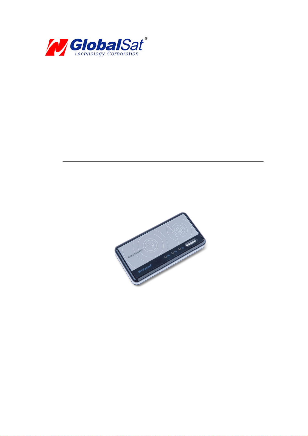
BluetoothGPSReceiver
Page 2

DOCUMENTREVISIONS
REVNO. DATE DESCRIPTION APPROVED
1.0 06-15-2006 Initialdocument BRF
1.1 07-21-2006 ConversiontoUSG textformat AAK
1.2.1 09-01-2006 Modifiedtext(Temp) AAK
© 2006 GlobalSat Technology Corporation/USGlobalSat, Inc. All rights reserved. The GlobalSat logo is a
trademark of GlobalSat Corporation. Windows is a register trademark of Microsoft Corporation. Acrobat is a
registeredtrademark of Adobe Systems Incorporated. Mac is a registered trademark of the AppleCorporation. All
other trademarks or registered trademarks are acknowledged as the exclusive property of their respective
owners.
All rights reserved. No part of this manual may be reproduced, transmitted, copied, or stored in any storage
medium, for any purpose, without prior written consent from GlobalSat Technology Corporation or USGlobalSat,
Inc. GlobalSat/USGlobalSat hereby grants the right to download one (1) copy of this manual onto a hard drive for
personal use.This manual is copyrighted and may containproprietaryinformation that is subject to change without
notice.
Page 3

BT-359 GPS
Table of Contents
PACKAGE CONTENTS..................................................................................................3
SYSTEM REQUIREMENTS ...........................................................................................3
WELCOME......................................................................................................................3
1. GETTING STARTED..................................................................................................4
2. THE BT-359................................................................................................................4
3. CHANGING THE BATTERY......................................................................................5
4. GPS FUNCTIONS......................................................................................................5
5. INITIALIZINGYOURGPSRECEIVER......................................................................7
6. USING / TESTING YOUR GPS RECEIVER (WIN / PPC only) ................................7
7. FAQ’s .........................................................................................................................9
8. CONTACT INFORMATION .....................................................................................10
9. SAFETY AND LEGAL NOTICES............................................................................10
10. LIMITEDWARRANTY...........................................................................................11
11. BT-359 SPECIFICATIONS....................................................................................12
PAGE2 OF 13
BT359_GPS_v1.2.1
Page 4
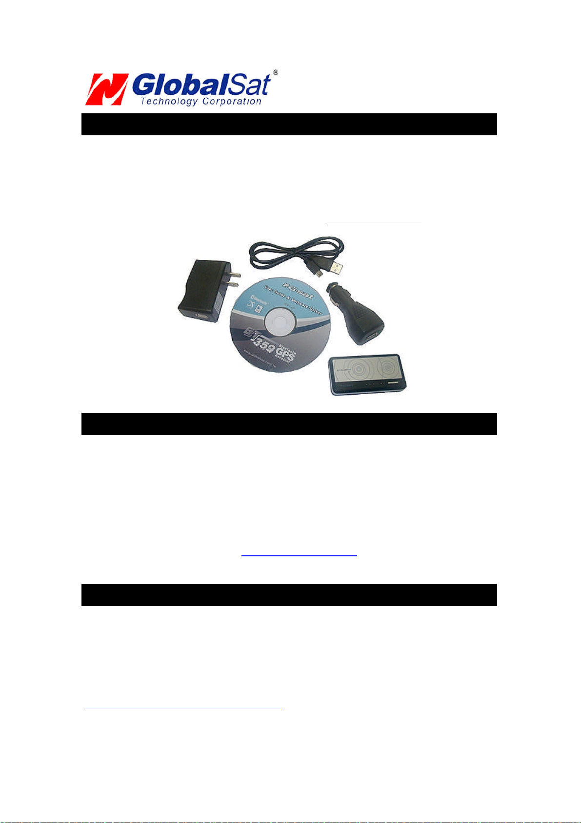
PACKAGE CONTENTS
- BluetoothGPS Receiver
- Driver CD-ROMwith User’sGuide andtest utility forWIN andMac O/S*
- 12VDCvehicle cigarette lighter
- 110/240 0.2AVAChome/officecharger (EuroAC Adaptersoldseparately#BT338-006A)
- USB charger interface cable
*Your can alsodownload InstallationGuidesfrom: www.USGlobalSat.com
BT-359 GPS
SYSTEM REQUIREMENTS
The GlobalSat Bluetooth GPS receivers requires a Bluetooth enabled device that can accept
accessory pairing, such as PDA’s, Smartphones, Laptops or Laptops with added Bluetooth USB
dongles.
Also a NMEA compatible navigation or map software for your operating system (O/S). Your 3rdparty
mapping/navigation software may have its own system requirements, please check with software
vendor fordetails.
A computer with a CD-ROM drive is only required to view the Users Guide, or load the test utility
program for eitherWindows or Mac operating systems. Thesefiles and programs are also availablefor
downloaddirectly fromourweb-site at: http://www.USGlobalSat.com
WELCOME
Thank youfor purchasing aGlobalSatBluetooth GPS receiver! GlobalSat GPSreceivers allowfor real-time street
navigation by using your laptop for graphical plotting and positioning of your route. Simply pair the GPS receiver,
with your Bluetooth enabled device, install your own personal mappingsoftware,andbegin to viewyour position in
real-timein relation to thesurroundingstreets in yourtravel area.
You’ll find that almost any NMEA compliant mapping/charting software will be compatible with the data from your
GlobalSat Bluetooth GPS receiver.. Visit our web-site for recommended mapping programs that you can use.
http://www.USGlobalSat.com/faq_details/Mapchart.asp
PAGE3 OF 13
BT359_GPS_v1.2.1
Page 5

BT-359 GPS
1. GETTING STARTED
GlobalSat Bluetooth GPSreceiversutilize a Bluetooth(shortdistancewireless protocol)anda built-in
active antenna for highsignaltracking sensitivity.Based on the SiRFStarIII Low Powerchipset,our
GPSreceiverssupport all functions (single satupdates in reducedvisibility, superior urban canyon
performance,foliage lockforweak signal tracking,etc.). OurBluetooth GPS receivers are wellsuited
forusewith PDA’s, Smartphones, tablet PC’sandnotebookPC’sandlaptops which are already
Bluetoothenable. GPS receivers can be usedin a wide variety of applicationsfrominvehicle
navigationto andoutdoor recreation and commercialapplications.
2. THE BT-359
The BT-359W shownabove and the BT359C (not shown) are models which can be found in North America, while
the BT-359S can also be found in Europe. There are no differences between these models with exception to the
cosmetic faceplate used. The “W” is a radiowave patter, the “C” is a glossy black faceplate, while the “S” has the
appearance ofa solarcellgraphic. Electronicallytheyare thesamedevice.
PAGE4 OF 13
BT359_GPS_v1.2.1
Page 6

BT-359 GPS
Pull Tab
Cover HooksHere
3. CHANGING THE BATTERY
1. Slidebatterycoverlock intotheopen UNLOCK positionandlift up carefully on batterycover from
lock end at seam where covermeetsthemain GPS housing.
2. Usethepull tabto liftout Li-ion battery.
3. Replace battery making sure thatthebattery contacton thebottomsideof battery touch the
contacts on the BT-359 within the battery compartment. (Pulltabshouldat thesame endas the
batterycoverlock)
4. Carefully hook the two catches ofthebattery coverto the GPS housing andgently close battery
cover.
5. Place batterycoverlockintothe“locked”position.
4. GPS FUNCTIONS
Turning theBT-359 ON / OFF
BT-359’s Power Button
Power ON:
Press the power button for 1 seconduntilthepower LEDbecomes lit.
Power OFF:
Press the power button 1 second untilthe powerLEDgoes off.
PAGE5 OF 13
BT359_GPS_v1.2.1
Page 7

BT-359 GPS
Power Jack
The mini-USB is a power jack that lets allows you to connect to either a DC vehicle charger or an AC
charger home/office charger for re-charging the internal Lithium-ion (Li-ion) battery. The voltage input
into the BT-359 must be 5VDC (01.6 A) center positive connector. You can also use the USB
interface cable to charge directly from your PC’s USB port. (The USB interface can only be used for
charging the GPS receiver’s battery and cannot be used to transfer data.) Upon powering your new
BT-359 GPS receiver for the first time it may require as much as 6 hours to fully charge, thereafter
charging times may be reduced. The built-in regulator will prevent your battery from being
overcharged, however it is always bestto unplug the GPSreceiver from thechargerafter charging has
completed andnotto leaveit connectedforextended periods oftime..
StatusLED Functions
Mini-USB Power Port
(not for datatransfer)
Power StatusLED (Red/Yellow):
Red----Batterypower is criticallylow.(chargeimmediately)
Yellow----Battery is currentlycharging.
LEDoff ----Batteryis charged (partial orfull).
GPSStatusLED(Green):
Blinking---- GPS positionisfixed (GPSsignalis being received)
Steadylight----GPS positionisnot fixed (noGPSsignal)
Bluetooth Status LED (Blue):
Blinking(Slowly)----Notconnectedto a Bluetooth device.
Blinking(Quickly) ---- Connectedto a Bluetooth device.
Auto Shut-Off (Power-Saving Mode)
Toconservebattery life,whenevertheGPSreceiverdoesnotdetecta Bluetooth signalforover10minutes,the BT359willautomaticallyshut off,butonlywhen operatingfromit’sinternalLi-ion battery.
Ifconnectedto an externalpowersource (ACor DC charger), thenthe BT-359 willremain on.
We stronglysuggest thatyoufirst test your USGGPS withthe includedGPS Infoutilityprogram to confirmthatthe
GPSreceiver if functioning properly on yourPC andthat youhavesuccessfully configured therightCOMPort
setting. Oncethis has beendone, close the GPSInfoprogramandstartyourapplicationfor COMport
configuration.
NOTE:Bydefault,yourPC willnot allowyou to runmultiple applications fromasingleCOMport. Itis important that
youcloseanypreviouslyopenedGPS application before switchingto anotherGPS applicationas the GPSreceiver
anddatawillnot be found bythe newprogram.
There are specialutilitiesavailable to split data into multipleCOMports foruse bymorethanoneapplication
simultaneously. (see: http://franson.com/gpsgate/)
PAGE6 OF 13
BT359_GPS_v1.2.1
Page 8

BT-359 GPS
5. INITIALIZING YOUR GPS RECEIVER
Before using your Bluetooth GPS receiver for navigation (especially for the first time), the receiver must
obtain a local GPS fix (coordinates) of the current position. To do this, take your device loaded and
configured with your mapping software to an open area that has a clear view to the sky. Start your
software (or the included GPS Info utility program) and wait for initialization of the GPS to complete.
This may take a few minutes depending on various factors such as the distance of the current
coordinates from the last time the GPS receiver was activated, GPS signal strength and surrounding
terrain (tall trees and buildings can block the satellite signals). Once the RAW GPS data is displayed
onto the screen, if applicable for your software, a fix has been initialized (Green LED on the GPS will
also start to flash). In some cases initialization can take up to several minutes depending on the
conditionsmentionedabovebefore complete GPSdatawillbe displayed on thescreen.
Coordinates scrolling withzero’s meansthat the portconnectionis complete, butthe satellite datais not
being received yet (possibly still initializing or in a badarea forsatellite reception).
6. USING / TESTING YOUR GPS RECEIVER (WIN/PPConly)
Onceyour Bluetooth GPSreceiver has beenpairedwith yourdeviceandyourpersonal mapping
softwarehavebeen installed andtheCOMport configuredproperly,youcanbeginto useyour
navigationsystem. If you don’t have a mapping, or navigationsoftware to try out your new GPS
receiver,we’veincluded a GPStest utilities called “GPSInfo”(GPSInfo.exe)for Windows and Pocket
PCdeviceslocated in theWin directory and“GPSUtility”(Mac_GPS_Utiltiy_V2.dmg) is locatedinthe
.Mac directoryof the CD-ROM.
Bothutilities can be download from our web-sitewww.USGlobalSat.com
Always select an area in thevehicle where the GPS unit will be secureand not obstructnormal driving,
visibilityand safety, butstillmaintaining a “viewto thesky”in orderto receive satellitedata.
WINandPPC devices:
Itis recommendedthat you first load andtestyour GPSreceiver withtheGPSinfo.exe. Thisprocess
will confirm youhave foundcorrect COM portnumberandhave configureditproperly.
1. RunGPSinfo.exe to loadtheutility.
2. Entertheproper COMport for your GPS device (seeCOMPortVerificationabove)
3. SetCOMport to Baudrate: 34800
4. If no errors have been made in configuration, there should be GPS data being displayed in the
window, which is confirmation thatthe communication between the GPS device and the “GPSinfo”
softwareis working properly.
5. Ifthere is no GPS datadisplayed(ordatawith multiple zerosinthem), please exit thesoftware and
unplugtheGPSreceiverfrom the USB portandreinsert it after 10 seconds to reset the device.
PAGE7 OF 13
BT359_GPS_v1.2.1
Page 9

BT-359 GPS
This screenshowsthesatellites beingreceived (numbers)andtheir signalstrengths.
NOTE: Configuration (or selection) of an assigned COM port for the GPS device from within your
mapping or chartingsoftware mustbecompletedwhenever using a softwareforthefirsttime.
Mac Users: Mac users needto run the Mac_GPS_Utiltiy_V2.dmg located in the .Macdirectory of the
CD-ROM ordownload the utility file fromourweb-site:www.USGlobalSat.com/mac
PAGE8 OF 13
BT359_GPS_v1.2.1
Page 10

BT-359 GPS
7. FAQ’s
Whatis thedifferencebetween the BT-359W and theBT-359S?
There isno differencebetween these twomodels withexceptionto thecosmeticfaceplate used. The“W” is a radio
wavepatter,while the“S” hasthe appearanceof a solarcell. Internallytheyarethe same device.
I am notgetting GPSdatainto myapplication on myWindowsPC.
1. Check yourDEVICE MANAGER to confirm theCOM Portnumberassigned to theGPS. Thenbesure
this is thesameCOM portnumberconfigured inyourapplication.
2. Besure your Baud rate isconfigured correctly at:
BaudRate: 38400
Data bit:8
Parity: None
Stop Bit:1
Flow Control:None
3. Configure theGPS Infoutilitywiththe correct COMPortandtestyourGPS receiver first before using it
inyourapplication.
WilltheGPS workwithotherStreet Mapping software?
GlobalSat GPS receivers providesstandardNMEAdataformapping softwareto useand convert to coordinates
andshould work well with mostanyNMEA compliantsoftware on themarket today.
Howaccurate is theGPS?
TheGloablsat GPSis WAAS/EGNOS capable, andforunitssoldinNorthAmericathroughauthorizedresellers,
theseunitsareWAAS/EGNOS enabled unless otherwise stated. Accuracycanbe between1~5meters2D RMS
withWAASenabled and10-15meters2D RMSWAASdisabled
Whatis ideal GPS environment?
TheGPS requiresan open,clear viewof thesky. Buildings,covered parking areas,tunnelsand densefoliagecan
causethe GPSreceiver to be unableto getalocationfix.
Ifyouareparked in a covered parkinglot orneara tall building, it isrecommended thatyou drive awayuntilyou
have a clearviewoftheskybefore usingtheGPSreceiver. Youmayneedto givethe GPSa few minutesto find or
geta fix itslocation.
Howdo I knowif the GPSis ON?
Ifyour PC is on andthe COMportwas configuredproperly, the GPSreceiveris on andreceiving thestreaming
GPSdata. Thiscanbeverified by openingyourmappingsoftwareprogram. Inaddition,theGlobalSatGPS has a
built-inLED status indicator thatshows thefollowing:
LEDOFF:GPS receiver isoff(nopower).
LEDON (solid): Nofix, searching forGPSsignals.
LEDFLASHING: PositionfixestablishedandGPS signalsarebeing received.
Whydoes theGPSnotworknearbuildings andothertall objects?
TheGPS usessatellitesin thespaceto findout where it is. Thereforeit needs aclearviewof the sky.Tallbuildings
andotherobjectsthatblockthe receiver’s viewto thesky makeit infeasibleto determineyourlocation. Sometimes
thesatellitesare notoverheadbut nearthehorizon.In thesecases theGPS musthavea clearviewof the horizon.
OtherComments-
Pleaseallowan adequate amount of timeforthe GPSreceiver’sboot-up(TTF)to complete beforecontacting
TechnicalSupport.
PAGE9 OF 13
BT359_GPS_v1.2.1
Page 11

BT-359 GPS
8. CONTACT INFORMATION
GlobalSat Technology Corporation (Taiwan)
www.GlobalSat.com.tw service@GlobalSat.com.tw
USGlobalSat,Inc.
www.USGlobalSat.com sales@GlobalSat.com(pre-sales GPS product questionsonly)
Technical Support (North America)
SeeourDOWNLOADSandFAQ section on our web-site for GPSsolutions, driver literatureupdates.
http://www.USGlobalSat.com/custom.asp?recid=7
Pre-registrationis requiredbeforereceiving anytype of technical support. Support issuessubmitted via
phone,faxore-mail (anymeansoutside of the recognized “Support Ticket”generatedfrom yourown
USGlobalSat registeredaccount) maynotbeanswered as quickly as witha “Support Ticket”.
Create your account andregister your productsat:www.USGlobalSat.com/support/custadminlogin.asp
9. SAFETY AND LEGAL NOTICES
Please read this section carefully before using the GPS receiver.
GlobalSatTechnologyCorporation/ USGlobalSat, Inc. will notacceptanyresponsibilitywhatsoeverfor
accidentsresulting from failure to observe commonsenseprecautions. Your personal judgment, traffic
regulations,and common sense mustalways take precedence over anydirectionsproducedby GPS
receiveror the mapping software
WARNING: Make sure that the GPS receiver is secure and does not interfere with driving visibility and
safety.
It is your responsibility as the vehicle operator to securely place the GPS unit and antenna so that they will not
interfere with driving and prevent operations of any safety device (such as the Airbag) in your vehicle. Do not
mountthedevicesin a place where thedriver or passengers mayreceive injuryduring vehicle operation or collision.
Foryoursafety, takecare torouteall cablesawayfromshifters,pedals, accessorycontrols and mechanisms.
WARNING: Drivesafelyanduse common sense.
Itisyourresponsibility as thevehicle operatorto drivesafely, observe all traffic rulesand above alluse your own
personaljudgmentwhiledriving. If youfeelthata routesuggested bythe navigation software instructsyou to
perform anunsafeor illegalmaneuver,placesyouinan unsafesituation,orroutes youintoan areawhichyou
consider unsafe,donot follow the instructions.
WARNING: Keep your eyesonthe road.
It is your responsibility as the vehicle operator to keep your eyes on the road and be an alert driver at all times,
especially whenthe vehicleis moving. Thevehicle’soperatorshould notbe distracted bythenavigationequipment
or software. Should there be a distraction with the ability to drive responsibly, please turn off the device. Should
youwant to look at the display for a prolonged time, park thecar safely, while following all trafficregulationsbefore
looking at thedisplay.
WARNING: To reduce the risk of fire or shock hazard, do not expose this product to rain or moisture. Do
not remove covers or open housings, there are no user serviceable parts inside. Refer servicing to
qualifiedpersonnel only.
PAGE10OF13
BT359_GPS_v1.2.1
Page 12

BT-359 GPS
10. LIMITED WARRANTY
GlobalSat/USGlobalSat warrants product hardware against manufacturing defects in material and workmanship
under normal use for a period of one (1) year from the original date of purchase (unless the product states
otherwise), and only when purchased from a recognized “authorized dealer”. Products purchased from any
unauthorized source, such as unauthorized e-Bay resellers, will not qualify for free warranty service/support and
may require the end-user to pre-pay fees associated with, but not limited to the support, repair, replacement and
shippingofthe productto andfromthe service center.
Except as provided herein, GlobalSat/USGlobalSat makes no express warranties’, including but not limited to any
warranties of merchantability or fitness for particular use, or non-infringement. You acknowledge that your use of
the product or service is at your sole risk and you agree that the information provided are without warranty of any
kindby GlobalSat/USGlobalSat.
Under no circumstances, including negligence, willGlobalSat/USGlobalSat or any of its affiliates, directors, officers
or employees, or any third party be liable for any direct, indirect, incidental, special or consequential damages that
results from youruse, or your inability to use,or the performanceof the product(s) with respect to any liability, loss,
orarising outof any breachof thiswarranty, including,but notlimitedtoany damages resulting from inconvenience,
loss of time, data, property, revenue, or profit or any indirect, special incidental or consequential damages. You
acknowledge that this limitation applies to all content information or other services available from
GlobalSat/USGlobalSat, and whether or not GlobalSat/USGlobalSat has notice of the possibility of suchdamages,
and whether or not to circumstances giving rise to such damages may have been within the control of
GlobalSat/USGlobalSat.
Some states do not allow the exclusion of certain warranties, so some of the above exclusions may not apply to
you. In those states, liability is limited to the fullest extent allowed by law By using the product(s), you agree to
indemnify GlobalSat/USGlobalSat and its parents, subsidiaries, affiliates, officers and employees and hold them
harmlessfrom anyand allclaimsandexpenses, includingreasonable attorney’s fees,asserted third partydueto, or
arising outof youruse oftheserviceand thesite.
Intheeventof a product defectduringthefirst 30-days of the warrantyperiod, youmayreturnproduct and thesales
receipt as proof of purchase date to place of original purchase, or you may contact GlobalSat/USGlobalSat’s
Technical support via our web-site for a Return Merchandise Authorization (RMA) number for return to
manufacturer.
GlobalSat/USGlobalSatwill, at itsoption,unlessotherwiseprovided by law:
a.) Correctthedefectby productrepair without chargeforpartsand labor;
b.) Replacetheproduct with oneof thesameorsimilar design;or
Refund the purchase price (only if purchased directly from USGlobalSat). All replaced parts and products, and
products on which a refundis made,becometheproperty of GlobalSat/USGlobalSat. Newor reconditioned parts
may be used in the performance of warranty service. Repaired or replaced parts and products are warranted for
the remainder of the original warranty period. You will be charged for repair or replacement of the product made
after the expirationof thewarrantyperiod.
This warrantydoes notcover:
a.) Damage or failure caused by or attributable to acts of God, abuse, accident, misuse, improper or
abnormal usage, failure to follow the instructions, improper installation or maintenance, alteration,lighting
orother incidence ofexcess voltageorcurrent;
b.) Anyrepairs otherthanthose providedby GlobalSat/USGlobalSat;
c.) Consumablessuch asfusesor batteries;
d.) Cosmetic damage;
e.) Transportation, shippingor insurancecosts;
f.) Costs ofproductremoval, installation,set-up service adjustment or reinstallation.
This warranty gives you specific legal rights, and you may also have other rights, which may vary from state to
state. Additional products bundled in this package not manufactured by GlobalSat/USGlobalSat will hold separate
warranties as expressed by the individual manufacturer of that product(s). Product specifications, functions and
featuresaresubject to changewithout notice.
PAGE11OF13
BT359_GPS_v1.2.1
Page 13

BT-359 GPS
11. BT-359 SPECIFICATIONS
Electrical Characteristics (Receiver)
GPSChipset SiRF Star IIIe/LP
Frequency L1,1575.42MHZ
C/ACode 1.023 MHz chiprate
Channels 20 all-in-viewtracking
Sensitivity -159dBm
Accuracy
Position Horizontal
Velocity 0.1m/sec 95%(SAoff),
Time 1 micro-second synchronized toGPS time
WAAS EnabledforNorthAmericaproducts (USGlobalSat, Inc)
Datum
Datum WGS-84
Acquisition Rate
Hotstart 1 sec., average (with ephemeris and almanacvalid)
Warm start 38sec.,average(withalmanacbut notephemeris)
Cold start 42sec.,average(neitheralmanac nor ephemeris)
Reacquisition 0.1sec.average (interruptionrecoverytime)
Protocol
GPSProtocol Default: NMEA0183 (Secondary: SiRF binary)
GPSOutput Data
GPStransfer rate Software commandsetting (Default: 38400,n,8,1for NMEA)
Connection
Dynamic Condition
AccelerationLimit Less than 4g
AltitudeLimit 18,000 meters(60,000feet)max.
VelocityLimit 515meters/sec. (1,000 knots)max.
Jerk Limit 20 m/sec3
Temperature
Operating 14°~140°F (-10°~60°C)
Storage -4°~158°F (-20°~70°C)
Humidity Upto 95% non-condensing
Power
Voltage 5V±5%
Batterycapacity 1100mAH
BatteryLife 11 hourscontinuoususe
Physical Characteristics
Dimension 3.23" x1.61"x0.53"(82 mmx41 mm x 13.4mm)
1~5m 2D RMSWAAS enabled
10m2D RMSWAAS disabled
SiRF binary >> position,velocity, altitude,status and control
NMEA0183MEA0183V2.2protocol,and supports
command:GGA, GSA, GSV, RMC, VTG,GLLv2.2 (VTG
andGLL areoptional)
Communication with hostplatformvia BluetoothSerialPort
Profile
Duetocontinuousproduct improvements, allspecificationsaresubject tochangewithout notice.
FCC NOTICE
Thisdevice complies withpart 15 of the FCCrules. Operation is subjectto the followingtwoconditions:
(1) Thisdevice may notcauseharmfulinterference, and
(2) Thisdevice mustacceptanyinterferencereceived,includinginterferencethatmaycauseundesired operation.
FCCRFExposurerequirements:
Thisdevice and its antenna(s)must not be co-locatedor operationin conjunction withany otherantenna or transmitter.
NOTE:THE MANUFACTURERIS NOT RESPONSIBLEFOR ANY RADIO OR TV INTERFERENCE CAUSED BY
UNAUTHORIZED MODIFICATIONS TO THISEQUIPMENT. SUCHMODIFICATIONSCOULD VOIDTHE USER'S
AUTHORITYTO OPERATE THEEQUIPMENT.
PAGE12OF13
BT359_GPS_v1.2.1
 Loading...