

Page 1

See what it’s like to na vigat e in 3D on a p ortabl e tou chscr een G PS.
aera® 796/795
Garmin International, Inc.
1200 East 151st Street, Olathe, KS 66062
p: 913.397.8200 f: 913.397.8282
Garmin (Europe) Ltd., Liberty House, Hounsdown Business Park, Southampton, Hampshire, SO40 9RB, U.K.
p: 44.1794.519944 f: 44.1794.519222
Garmin Singapore Pte. Ltd., 46 East Coast Road #05-06, Singapore
p: 65.63480378 f:65.63480278
©
2011 Garmin Ltd. or its subsidiaries 09/11 M02-10225-00
Navigation features
Waypoints:
Total: 3000 with 10 characters (name and symbol)
Nearest: Continuously updated; Airport, VOR, NDB, INT, user,
ARTCC, FSS, airspace, Wx, city
Routes: 50 reversible routes with up to 300 points each
Tracks: 10,000 point automatic track log; 15 saved
tracks; 1,000 points per saved track; lets
you retrace your path in both directions
Map datums: More than 100 plus user datum
Position format: Lat/Lon, UTM/UPS, Maidenhead, MGRS,
Loran TDs and other grids, including user grid
GPS performance
Receiver: WAAS enabled, high-sensitivity GPS receiver continuously
tracks and uses up to 12 satellites to compute and
update your position
Acquisition times:
Warm: Less than 5 seconds
Cold: Less than 45 seconds
AutoLocate™: Less than 60 seconds
Update rate: 5/second, continuous
GPS accuracy:
Position: < 10 meters
*
Velocity: 0.05 meter/sec steady state
DGPS (WAAS) accuracy:
Position: < 5 meters
Velocity: 0.05 meter/sec steady state
Interfaces: Two RS232 ports with NMEA 0183 data format and
proprietary GARMIN USB interface. Accepts Aviation
input format from panel-mount GPS. Also can connect
to Garmin SL30 and SL40 for frequency tuning and GTX
330 for TIS traffic alerts.
GPS Antenna: Internal
Differential: WAAS
Moving map features
Basemap: Built-in basemap shows roads, lakes, rivers, metro areas
and surface features
Database: Built-in Jeppesen® database with terrain and obstacle
databases**. Includes Americas, Atlantic International, or
Pacific International coverage, plus airport, FSS, ARTCC,
and weather frequencies.
The aera 796 includes locations for private airports
and heliports (U.S.and Europe) and visual reporting points
(Europe). Garmin SafeTaxi data supports detailed airport
and taxiway diagrams at over 1,000 U.S. airports.
Pre-loaded Garmin FliteCharts® data card includes all
published instrument approach plates and terminal
procedures (U.S. only).
Approach waypoints:
Jeppesen® data also includes final approach sequence
waypoints for all published approaches
AOPA Airport Guide
AOPA directory (included on the 795/796 Americas
version) contains detailed information on over 7,400 U.S.
airports, along with airports of entry for Canada, Mexico
and the Caribbean. Includes names and telephone
numbers of aircraft services, fuel outlets, transportation,
and more.
AC-U-KWIK Airport Directory:
AC-U-KWIK airport data (included on the 795/796 Atlantic
and Pacific database versions; optional on Americas version)
features worldwide coverage with detailed site information
on over 7,800 airports throughout North America, Europe,
Asia, Central America, the Caribbean, South America,
Africa and Australia.
Uploadable maps: Supports optional detailed cartography, including City
Navigator
®
street mapping which allows the user to
search and locate any desired surface address for use as a
flight plan waypoint or for “direct-to” aerial navigation.
Power
Source: Replaceable, rechargeable Lithium-ion battery
Battery life: 3 - 8 hours of use (nominal). Includes power for SiriusXM™
receiver. Decreasing screen brightness can greatly increase
battery life.
Physical
Size: 5.1”W x 8.0”H x 1.5”D
(13.0 x 20.3 x 3.8 cm)
Weight: 1.65 lb (.75 kg) with battery
Display: 7.0” diagonal (17.78 cm) 480 x 800 pixels,
color sunlight readable WVGA TFT with adjustable
backlighting (600 nits)
Accessories
Standard Protective case and cleaning cloth
USB interface cable
GA 25 external GPS antenna
GXM 40 smart antenna (796 only)
Free single database update (includes Navigation,
FliteCharts®, SafeTaxi®, obstacles and towers ,
airport directory)
DC cigarette adapter 12/24 volt cradle
Home A/C cradle dock
Yoke mount
Quick reference guide
Optional: MapSource CD-ROMs
Power-Data cable
Replacement Lithium-ion battery pack
Knee mount
aera® 796/795 specifications
Page 2
FEATURES:
• Menu-driven touchscreen interface
simplifies operation
• Features 3D Vision perspective
view terrain on flight display
• Supports “paperless cockpit”
concept with a digital document
viewer, scratch pad, and preloaded electronic charts
• Selectable screen orientation –
Portrait or Landscape
• Geo-referenced Garmin FliteCharts
®
feature electronic versions of
AeroNav
™
(formerly NACO) IFR
approach plates and terminal
procedures for U.S. airports
• Initial geo-referenced AeroNav
™
IFR Enroute and VFR Sectional
charts come pre-loaded
• Garmin SafeTaxi
™
data provides
detailed taxiway diagrams and
position information for over
1,000 U.S. airports
• AOPA Airport Directory data offers
detailed information on over 7,400
U.S. airports, along with airports
of entry for Canada, Mexico and
the Caribbean. Includes names
and phone numbers of FBOs and
fuel/service facilities, plus ground
transportation, ATC data, and more
• For international flyers, optional
AC-U-KWIK airport directory
database features information on
more than 7,800 airports worldwide
• IFR map mode displays Victor
airways and Jet routes, derived
from the navigation database
• Traffic Information Service (TIS)
alerts are supported via Garmin
GTX 330 Mode S Transponder
interface
• Supports XM WX satellite weather
data and SiriusXM
™
audio
entertainment
1
(aera 796 only)
• A second serial port with USB
interface allows more cockpit
connectivity, with simultaneous
access to multiple devices
• Fast 5 Hz GPS update speed gives
a super-smooth presentation
of flight data for added realism
and safety
1
XM subscription required (sold separately)
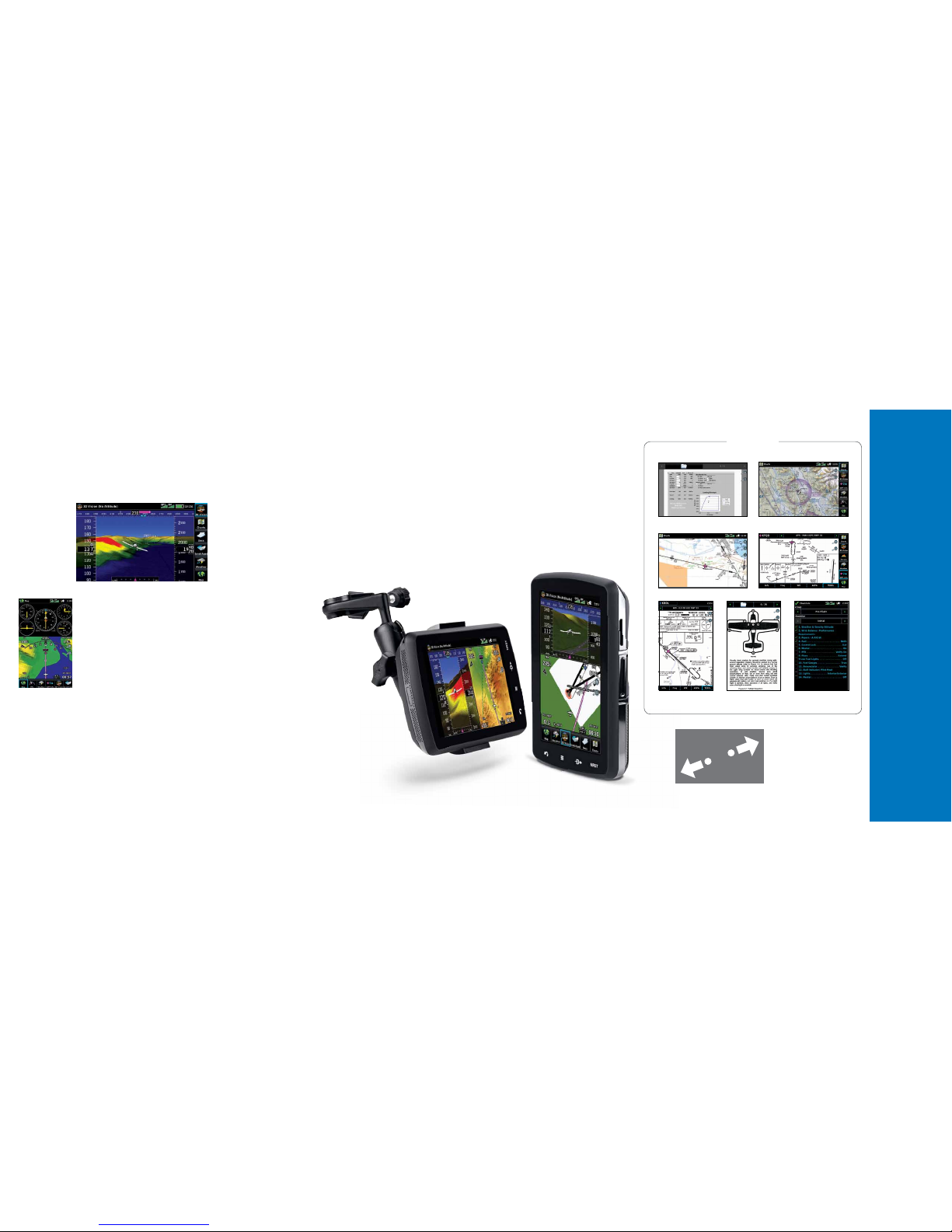
With its unique 3D Vision perspective view imagery of database-
generated flight terrain, the new aera® 796 is a real breakthrough
in carry-on GPS navigation. A dedicated aviation device featuring
a big 7-inch capacitive
touchscreen display, this
new unit is Garmin’s
most visionary portable
yet. Viewable in portrait
or landscape orientation,
the aera’s “virtual reality”
flight graphics can be
framed with GPS-derived
indications of ground track,
altitude, groundspeed,
vertical speed and turn indication. Geo-referenced FliteCharts®1,
AeroNav IFR Enroute and VFR Sectional
charts1, SafeTaxi®1 diagrams, low and
high altitude airways, and AOPA Airport
Directory1 data all come pre-loaded.
Plus, a built-in digital document viewer
expands the unit’s utility as an electronic
flight bag (EFB) – enabling you to load
and view PDF documents, JPEG photos,
and other electronically formatted
materials of all kinds: Everything from
checklists and raster charts to detailed
performance/procedural data from the
aircraft flight manual. There’s also a convenient scratch pad for writing
down clearances or other important notes. For helicopter pilots
(or others who sometimes need to navigate to specific ground locations
or addresses), the additional support of optional City Navigator® mapping
allows the user to search and locate any desired surface address for use
as a flight plan waypoint or for “direct-to” aerial navigation. And for
pilots who prefer the Jeppesen format for charts and diagrams, Garmin
also offers an electronic ChartView™ enablement option (subscription
required), utilizing Jeppesen’s extensive data library to provide global
charting capabilities. Moreover, if your flight planning takes you beyond
the shores of North America, your aera 796 is optionally available with
an AC-U-KWIK international database which details airport directory
information on more than 7,800 locations worldwide.
Situational awareness made simple.
A true aviation portable, the aera 796’s physical design clearly enhances
ease-of-use and adaptability in the cockpit.
It’s sized to fit most aircraft yokes – or it
can comfortably be used as a knee-mounted
device. There are four touchkeys on the bezel
of the unit representing “Back”, “Menu”,
“Direct-To” and “Nearest” selections
for quick navigation to frequently used
functions. Also, because the aera 796 menu
is customizable, you can easily pick favorite
features or pages to anchor as icons along the
bottom of the screen for even faster access.
The touchscreen interface allows you to quickly pan across the map and
“pinch zoom” to magnify or downscale map detail. Plus, with the flick
of a finger, you can also rotate the 3D Vision vantage point completely
around the aircraft for easy scanning of the surroundings. When flying
in areas or at altitudes where rising topography may pose a hazard, the
aera 796 uses its terrain-alerting database to colorize the landscape –
clearly showing with amber or red overlays those areas where potential
flight-into-terrain risks may exist. Likewise, any towers or obstacles that
may encroach upon your flight path are color-highlighted and clearly
displayed with height-appropriate symbology. The aera 796 also has the
ability to display TIS (traffic information service) alerts, where available,
by connecting to a compatible traffic source such as Garmin’s GTX 330
Mode S transponder.
3D m eets portability in the new aera® of large-format touchscreens
Two times the connectivity.
A second serial port gives the aera® 796 even more ability to connect
and communicate with external cockpit systems than its predecessor
design. With two serial ports, pilots can display traffic information
or send frequencies to a Garmin SL30 or SL40 VHF radio, while
simultaneously sending position information or other data to select
systems or devices onboard the aircraft. A GXM 40 Smart Antenna,
included with the aera 796, provides North American customers with
access to datalinked NEXRAD imagery and other XM WX® satellite
weather capabilities – plus some 170+ channels of digital audio
programming2 through SiriusXM™ satellite radio. And because the
GXM 40 is powered through the aera 796 with a USB connection,
the setup is simple – allowing the satellite weather and radio functions
to operate for up to four hours without external power. Alternatively,
for users in areas beyond the reach of XM coverage, Garmin’s aera 795
model offers the same overall functionality as the 796, without the
XM satellite weather/entertainment capabilities.
Touchscreen interface with handy
“pinch zoom” feature lets you quickly
magnify or downscale graphical detail
within the viewing area by simply
dragging your finger and thumb
together (zoom out) or apart (zoom in).
Geo-referenced U.S. FliteCharts come pre-loaded IFR map mode shows high and low enroute airways
VFR Sectional chart data with geo-referencing is
included for the U.S.
Electronic checklist capability
keeps cockpit paperwork to a
minimum
PDF document viewer offers
easy access to aircraft flight
manual data
GO PAPERLESS
Jeppesen-format electronic
charts available with optional
ChartView
™
AERA 796 HAS
A CONVENIENT
“SCRATCH PAD”
FOR WRITING DOWN
CLEARANCES
OR OTHER NOTES
1
IFR FliteCharts, VFR Sectional charts, SafeTaxi and AOPA Directory are for U.S. only
2
XM subscription required (sold separately). See XM WX for coverage areas and subscription plans
Electronic flight bag functions can display
Weight & Balance documents
 Loading...