

Page 1
Apollo 360 Map Display
Quick Reference Guide
Use this Quick Reference Guide to quickly review:
n
How to use the six navigation screens, with special information on:
q
Moving maps Zoom feature
n
How to view the nearest waypoints using the GOTO/NRST key
n
How to get extra waypoint information using the INFO key
n
How to create custom waypoints with the WPT key
n
How to use features available with the MENU key
Power Up
The Apollo 360 Map relies on inputs from a host navigation device to
establish its position. When the unit is powered on, it will first look for
an input from the host device. If the input is present, it looks for position
and route information. With position and route information available, the
Apollo 360 Map is ready to begin assisting in navigating a trip. Refer to
the Users Guide — Getting Started section for additional details..
P/N 561-0163-00 Copyright November 1996 II Morrow Inc.
Page 2
Introduction to the Apollo 360 Apollo 360 Map Display
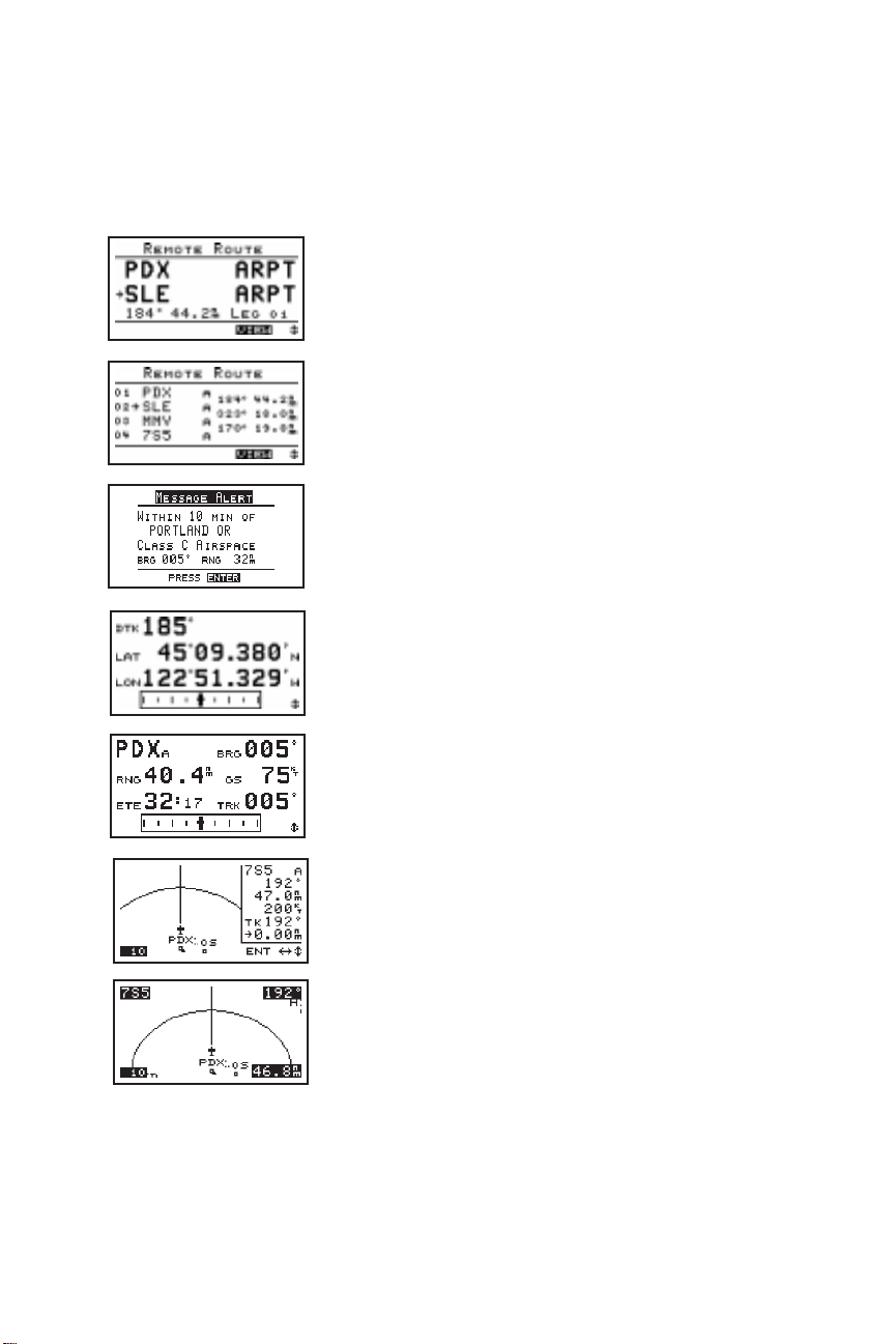
The six navigation screensform the core of the Apollo 360 interface, and are
displayed whenever not accessing the MENU, GOTO/NRST, WPT, or
INFO functions. Rotate the LARGE knob to view each screen. For full
details refer to the User’s Guide — Chapter: Topic as indicated below.
Routes (two screens available)
The arrow indicates the current TO waypoint.
Additional information for using routes is provided
on the next page. Refer to Navigating a Trip:
Route subsections. Go to Screen Controls under the
Main Menu to select either the 1-Leg or 3-Leg
route screen
Current messages
Press the ENT key to view additional messages.
Refer to Navigating a Trip: Current Messages
Screen.
Present position
Refer to Navigating a Trip: Present Position
Screen.
General navigation information
Refer to Navigating a Trip: Bearing / Range /
Ground Speed Screen.
Moving maps (two screens)
The lower left corner of the moving maps shows
the current map Zoom scale, which is changed by
rotating the SMALL knob. The Auto Zoom scale
automatically zooms in on the TO waypoint as
you fly. Refer to the Navigating a Trip: Moving
Map sections, and Navigating a Trip: Zooming In
or Out and Auto Zoom sections.
II Morrow Inc. Copyright November 1996 P/N 561-0163-00
Page 3

Apollo 360 Map Display Introduction to the Apollo 360
Using Routes
The Apollo 360 Map displays route information from the host navigation
device in either a 1-Leg or 3-Leg route screen. The screen shows either
two or four waypoints (depending on the screen selected) of the current
route, as well as the desired track and distance between the displayed
waypoints. The 1-Leg screen uses larger characters for easier viewing.
The 3-Leg screen provides more information on a single screen.
To change the route screen selection, press the MENU key. Rotate the
LARGE knob to select Screen Controls then press the ENT key. Rotate
the SMALL knob to select 1-Leg or 3-Leg and press the ENT key twice
to return to the navigation mode.
To search for nearest waypoints, press the
GOTO/NRST key. The nearest 30 waypoints will
be displayed in order of distance from your
present position. The waypoint type, bearing to
the waypoint and range to the waypoint also
shows.. Refer to Navigating a Trip: Searching for
Nearest Waypoints.
To view waypoint information, press the INFO
key. When displaying navigation screens,
information is for the TO waypoint. When
viewing the nearest waypoints, rotate the LARGE
knob to select a waypoint then press the INFO key
to display information for that waypoint. Rotate
the LARGE knob to view additional information
screens. Press the INFO or ENT keys to exit the
Info screen. Refer to the User’s Guide —
Waypoint Database.
Create User waypoints at any time by pressing
the WPT key. Change the waypoint information
by rotating the LARGE and SMALL knobs. When
complete, press the ENT key. Refer to Navigating
a Trip: Creating Waypoints.
P/N 561-0163-00 Copyright November 1996 II Morrow Inc.
Page 4

Introduction to the Apollo 360 Apollo 360 Map Display
The MENU key accesses the Main Menu, which
provides system setup information. While viewing
this screen, rotate the LARGE knob to select a
menu option, then press the ENT key to view the
option screen.
To return to the navigation screens at any time,
press the MENU key, then press the ENT key.
Main Menu Options
Return To Nav: Return to the navigation screens
Screen Controls: Change between 1-leg and 3-leg route display,
change contrast and brightness settings
Map Setups: Choose moving map display options for airspaces,
route paths, and map orientation
Declutter Maps: Choose which types of waypoints are displayed on
the moving maps and in the nearest waypoints list
Track Point Hist: Choose whether a trail showing where you have
been is displayed on the moving maps
Arrival Alerts: Choose the waypoint arrival alert radius
Airspace Alerts: Choose the airspace alert options for distance and
time
Countdown Time: Start a countdown timer to give an alert message
Display Units: Choose distance, altitude, and position units of
display for navigation
User Wpt Mgmt: Modify or delete waypoints that were created
with the WPT feature
System Info 1: View current version information
Refer to the Users Guide — Menu Function Options for detailed
information.
II Morrow Inc. Copyright November 1996 P/N 561-0163-00
 Loading...