

Page 1
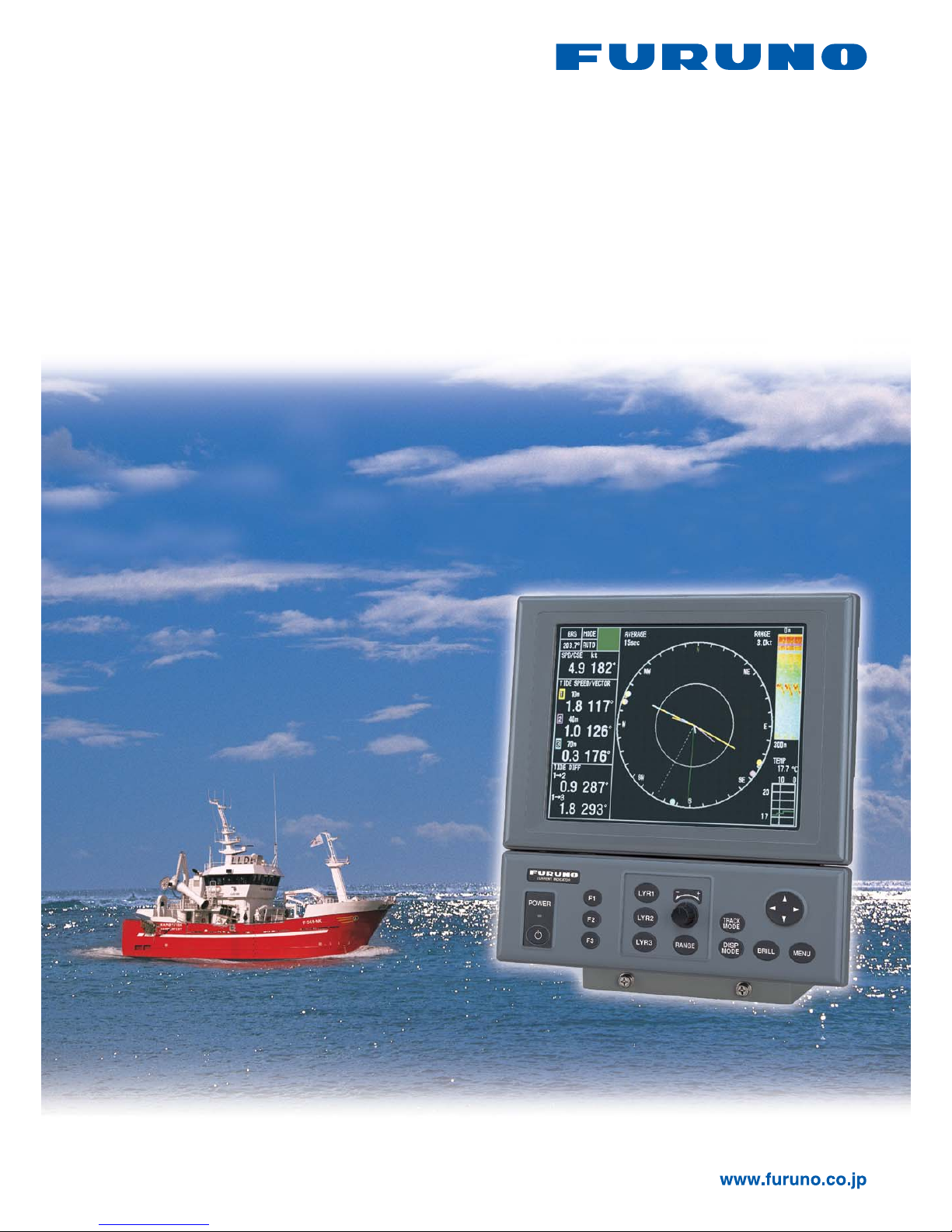
Model CI-88
10.4" LCD, Compact and High accuracy
DOPPLER SONAR
CURRENT INDICATOR
Page 2
■ Compact design and single-mold
transducer for ease of installation and
maintenance
■ High definition 10.4" color LCD for
displaying tide current detections
■ Blackbox system configuration allows
use of commercial VGA monitors
■ Continuous display of tide speed and
direction at the three selected depth
layers
■ Tide speed/direction and ship's track
can be plotted on screen for larger
area tide observation
■ Triple-beam system for less error in
tide current detection
■ True tide current presentation
with external GPS navigator and
Gyrocompass inputs at deep water
locations
■ Water temperature graph helps locate
current rip (Temperature sensor
required)
The FURUNO CI-88 is a Doppler Sonar Current
Indicator designed for every type of fishing vessels
and hydrographic survey vessels. The high-definition
10.4” color LCD continuously presents tide speed
and direction at three depth layers simultaneously in
addition to ship’s speed and drift. This variety of current
information allows you to predict net shape and plan
when to throw your net.
There are six presentation modes: tide vector, ship’
s speed, echo level, text, track and tide log. Mode
selection is simple by pressing the dedicated button.
Other menu settings are also easily made by using
the cursor pad or rotary knob. The CI-88 features the
unique, user customizable “function button” to shortcut
menu operation. Once you have registered
the often-used function, then just press the dedicated
button and then the function window pops up.
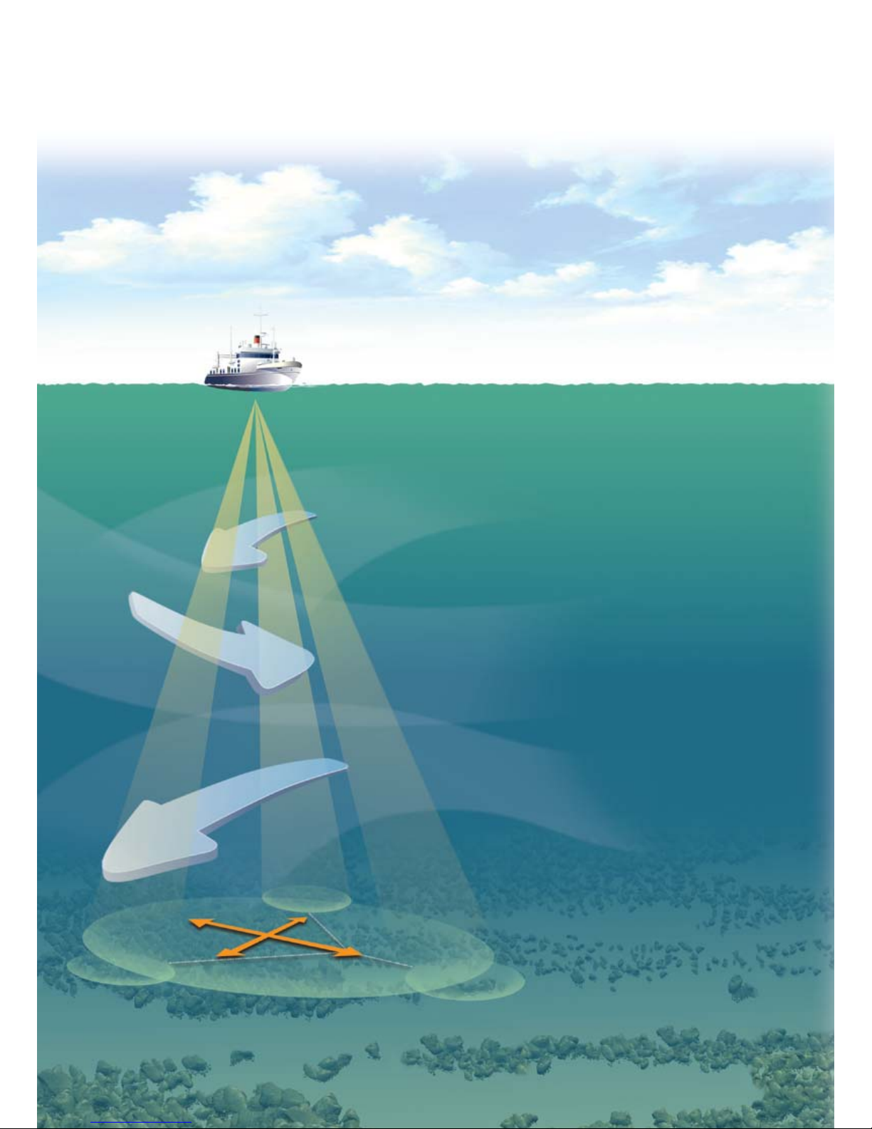
The CI-88 has a triple-beam emission system for
providing highly accurate current measurement.
This system greatly reduces the effects of rolling,
pitching and heaving motions, providing a continuous
display of tide information.
There are four modes for measurement: ground
tracking, water tracking, NAV and Automatic. In the
NAV mode, when ground (bottom) reference is not
available acoustically in deep water, the CI-88 can
provide true tide current information by receiving
position data from a GPS navigator and heading data
from a gyrocompass or a GPS compass.
The CI-88 consists of a display unit, a processor unit
and a transducer. The control unit and display unit
can be installed separately for flexible installation.
A BlackBox configuration(without monitor) is also
available.
Page 3
Increase your fishing efficiency by using
highly accurate current information
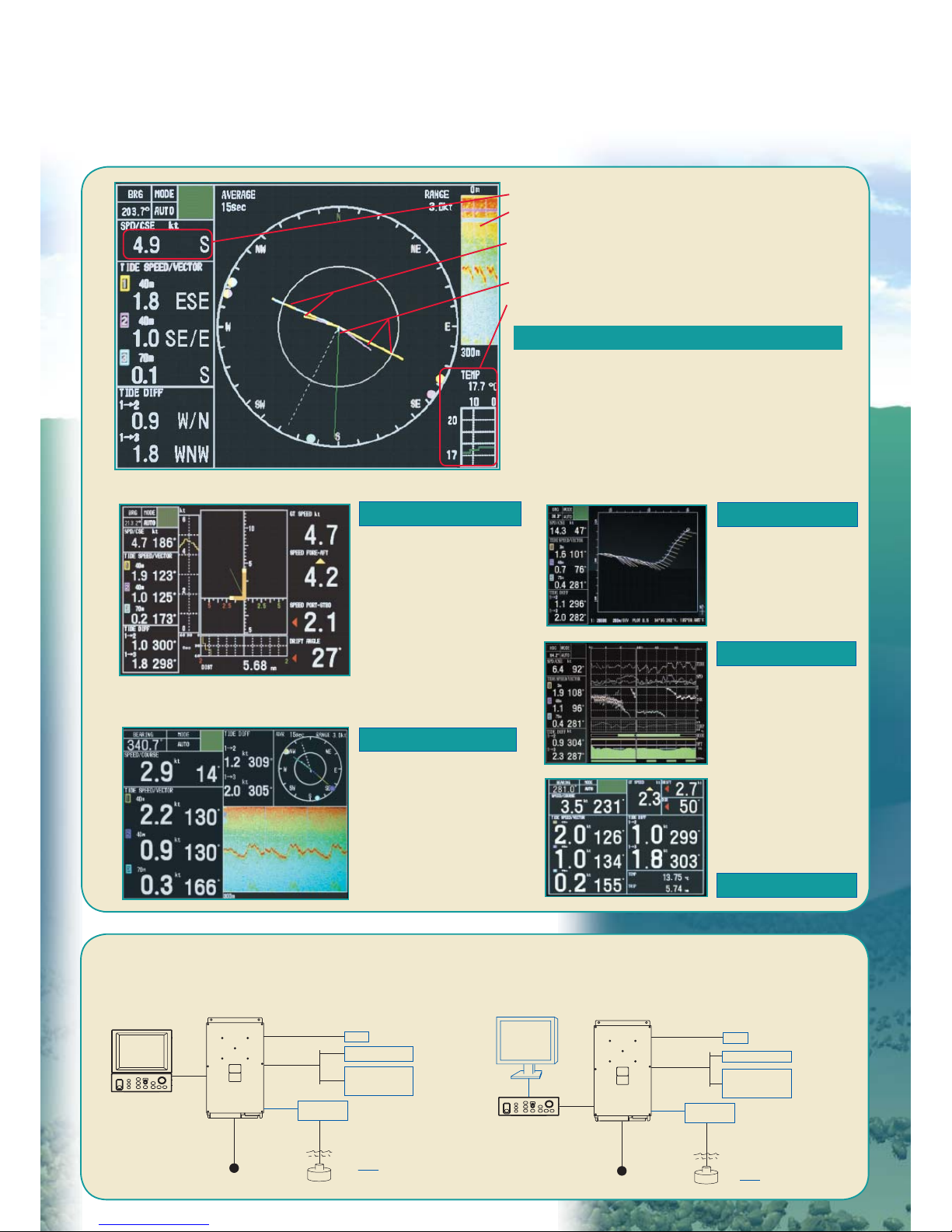
INTERCONNECTION DIAGRAM
BlackBox configuration (with custom monitor)
Standard configuration (with standard LCD monitor)
24 VDC
10/20 m
5/10/15/
20/30 m
Display Unit*
MU-100C
Control Unit*
CI-6888
Gyro
10/20/
30/50 m
AD-10
Satellite Compass
NMEA0183
GPS
Echo Sounder
Scaning Sonar
Option
Transceiver Unit
CI-8810
*Display unit and control unit
can be mounted separately
with an optional cable
Junction Box
CI-630
24 VDC
Control Unit
CI-6888
Gyro
10/20/
30/50 m
AD-10
Satellite Compass
NMEA0183
GPS
Echo Sounder
Scaning Sonar
VGA Monitor
*
Option
Transceiver Unit
CI-8810
10/20 m
5/10/15/
20/30 m
Junction Box
CI-630
*640 x 480 pixels
Increase your fishing efficiency by using
highly accurate current information
TIDE VECTOR
SHIP'S SPEED
TEXT
TRACK
TIDE LOG
ECHO LEVEL
Tide speed and direction for the three depth layers
are displayed with vectors. The depth of each
layer can be set manually in 1 m intervals. Other
information such as tide differential between the
reference and one of the two other layers, heading
and course can also be displayed in large text.
Displays the speed
components for foreaft and port-stbd. The
synthesized vector (green
line) intuitively shows
drift direction. The speed
source is selectable on the
menu from ground tracking
or water tracking.
Displays echogram
obtained from each
beam. It helps evaluate
the concentration or
distribution of fish school
or seabed at three
directions simultaneously.
Tide vectors can
be shown on the
ship's track in userspecified intervals.
Displays the tide
information over
the past twelve
hours.
Ship’s speed and course
Echograms
Water temperature
(external temp. sensor required)
Tide vectors for speed and direction
Layer 1, 2 and 3
Tide vectors for tide differences
Layer 1 and 2
Layer 1 and 3
Page 4
FURUNO U.S.A., INC.
Camas, Washington, U.S.A.
Phone: +1 360-834-9300
Fax: +1 360-834-9400
FURUNO ELECTRIC CO., LTD.
Nishinomiya, Hyogo, Japan
Phone: +81 (0)798 65-2111
Fax: +81 (0)798 65-4200, 66-4622
FURUNO (UK) LIMITED
Havant, Hampshire, U.K.
Phone: +44 23 9244 1000
Fax: +44 23 9248 4316
FURUNO FRANCE S.A.
Bordeaux-Mérignac, France
Phone: +33 5 56 13 48 00
Fax: +33 5 56 13 48 01
FURUNO ESPAÑA S.A.
Madrid, Spain
Phone: +34 91-725-90-88
Fax: +34 91-725-98-97
FURUNO DANMARK AS
Hvidovre, Denmark
Phone: +45 36 77 45 00
Fax: +45 36 77 45 01
FURUNO NORGE A/S
Ålesund, Norway
Phone: +47 70 102950
Fax: +47 70 102951
FURUNO SVERIGE AB
Västra Frölunda, Sweden
Phone: +46 31-7098940
Fax: +46 31-497093
FURUNO FINLAND OY
Espoo, Finland
Phone: +358 9 4355 670
Fax: +358 9 4355 6710
FURUNO POLSKA Sp. Z o.o.
Gdynia, Poland
Phone: +48 58 669 02 20
Fax: +48 58 669 02 21
FURUNO DEUTSCHLAND GmbH
Rellingen, Germany
Phone: +49 4101 838 0
Fax: +49 4101 838 111
LLC “FURUNO EURUS”
St. Petersburg, Russian Federation
Phone: +7 812 767 15 92
Fax: +7 812 766 55 52
TRADEMARK REGISTERED MARCA REGISTRADA
SPECIFICATIONS SUBJECT TO CHANGE WITHOUT NOTICE
08073KS Printed in Japan
Catalogue No. M-1531a
Display
10.4" TFT color LCD, 640 x 480 pixels
Measurements
Current
Speed: 0 to 9.9 kt
Direction: 0 to 360°
Number of layers: 3 layers
Ship
Speed: -10 to 30 kt (fore-aft)
-9.9 to +9.9 kt (port-starboard)
Direction: 0 to 360°
Depth Range
For current measurement
2 to 75% of water depth up to 100 m
(Over 10 m of water depth is required in Ground tracking
mode. Over 40 m water depth is required in Water Tracking
mode.)
For ground tracking
3 to 200 m
Accuracy
Current: ± 2% of ship's speed + 0.2 kt
Ship's speed: ± 1% + 0.1 kt
Number of Beams Three beams
Tilt 60° each
System Frequency 288 kHz
Data Interface (NMEA 0183 Ver.1.5/2.0/3.0, IEC 61162)
Inputs:
DBT, DPT (Depth), GGA, GLL, RMA, RMC (L/L),
HDG, HDM, HDT (Compass), MTW (Water temperature),
VTG (SOG, COG), ZDA (UTC)
Outputs:
CUR (Water current layer), VBW (Dual Ground/Water Speed),
VDR (Set and Drift), VHW (Water speed and heading), VLW
(Distance travelled through the water), VTG (SOG, COG)
ENVIRONMENTAL
(IEC 60945 test method)
Temperature Display Unit: -15° to +55°
Control Unit: -15° to +55°
Transceiver Unit: -15° to +55°
Waterproofing Display Unit: IPX0 (IEC 60529)
Control Unit: IPX2 (IEC 60529)
Transceiver Unit: IPX0 (IEC 60529)
POWER SUPPLY
24 VDC, 110 W (TX)
EQUIPMENT LIST
Standard
1. Display Unit MU-100C
2. Control Unit CI-6888 1 unit
3. Transceiver Unit CI-8810 1 unit
4. Transducer CI-8840-1 with 10 m cable 1 unit
5. Thru-hull Pipe for steel hull TFB-5000CI 1 pc
6. Installation materials and spare parts 1 set
Optional
1. Junction Box CI-630
2. Transducer CI-8840-2 with 20 m cable
3. Transducer Tank
CI-820/821/822/823
4. Cable for Transceiver - Junction box
Z-6FVNV-SX-C, 5/10/15/20/30 m
5. Cable for Display - Control Unit
66S1239-0, 5/10 m
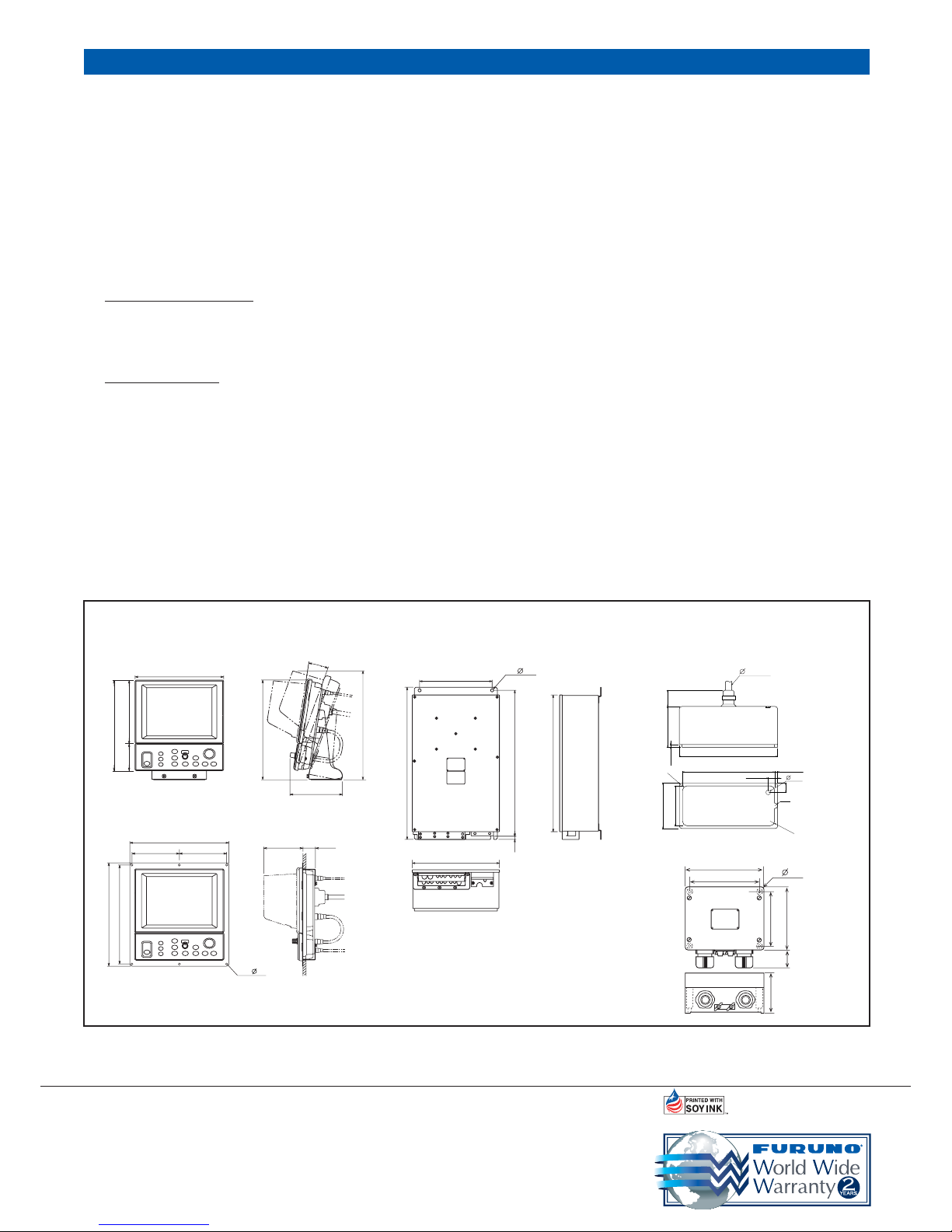
SPECIFICATIONS OF CI-88
Display Unit and Control Unit
6.0 kg, 13.2 lb
Transceiver Unit
Transducer
12.0 kg, 26.5 lb
140 5.5"
160 6.3"
43 1.7"
100 3.9"
200 7.9"
(180 7.1")
4- 6.5
MU-100C and CI-6888
CI-630
CI-8810
CI-8840-1
with 10 m cable 6.1 kg, 13.4 lb
CI-8840-2 with 20 m cable 8.9 kg, 19.6 lb
357 14.1"
171 6.7"
11°
327 12.9"
290 11.4"
300 11.8"
210 8.3"
90 3.5"
320 12.6"
320 12.6"
334 13.2"
153 6.0"
153 6.0"
6- 7
127 5.0"
41
1.6"
280 11.0''
590 23.2''
530 20.9''
566 22.3''
12
0.5''
4- 12
336 13.2''
13. 2
R10
210 8.2"
197 7.8"
20 0.8"
20
0.8"
6 0.2"
35
1.4"
88.5
3.5"
98.5 3.9"
86.5 3.4"
6.5
0.3"
10
R5
R6
6.0 kg, 13.2 lb
Flush Mount Type
Junction Box
2.0 kg, 4.4 lb
 Loading...