


FIMI X8 SE User Manual
Please read the user manual carefully before using and keep the manual for future reference.

V1.0
Services & Support
FIMI provides X8 SE users with tutorial videos and the
following information:
1. FIMI X8 SE User Manual
2. FIMI X8 SE Quick Start Manual
3. FIMI X8 SE Disclaimer and Safety Operation Instructions
Users are advised to watch tutorial videos before using the product and read
FIMI X8 SE Disclaimer and Safet y Operation Instructions carefully and get to
know the process of using by going through FIMI X8 SE Quick Star t Manual.
For more product information, please refer to FIMI X8 SE User Manual.
Please download the firmware and watch the tutorial videos through the
link below https://ww w.fimi.com/fimi-x8-se.html
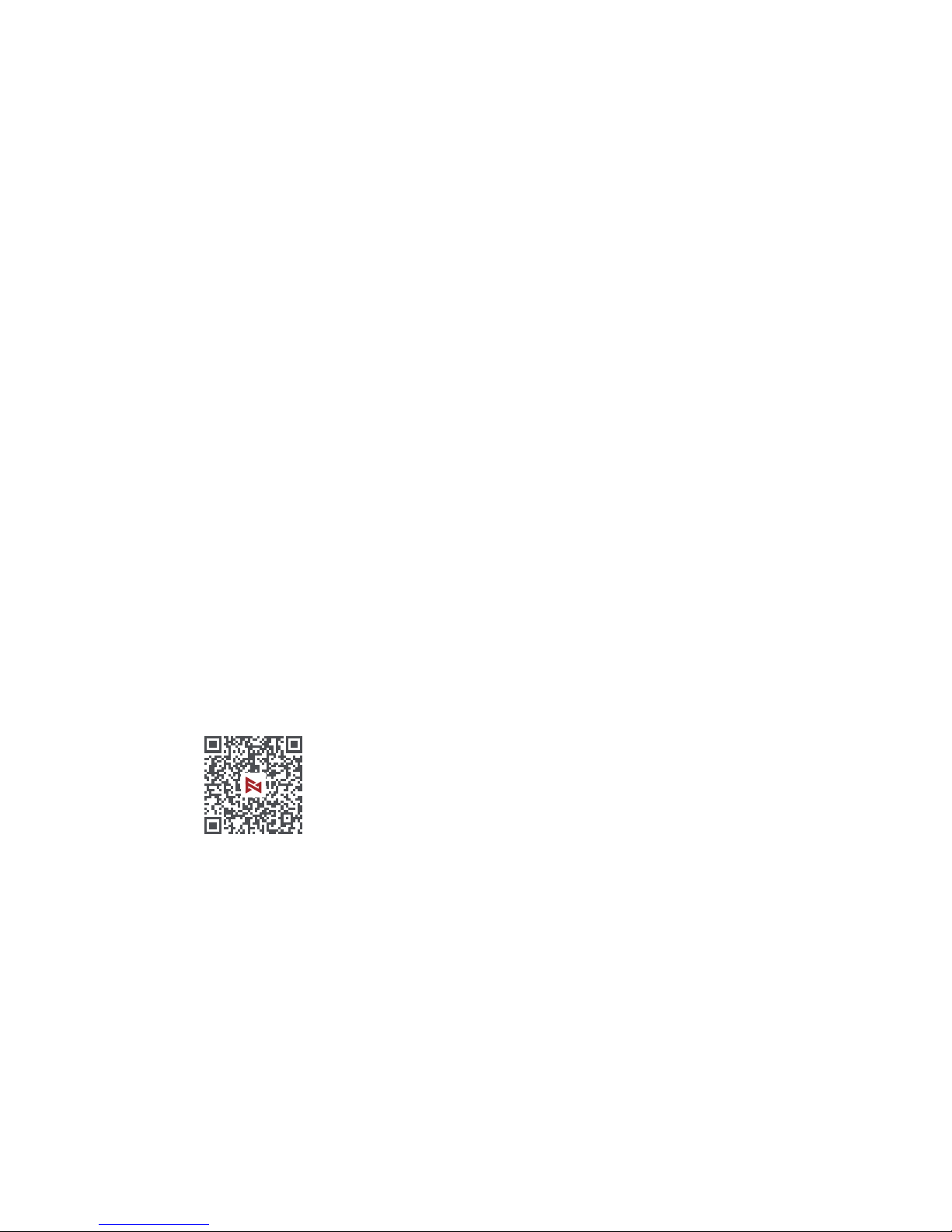
4. Please scan the QR code below to download Fimi Navi app
X8 SE is a foldable and portable quadrotor drone integrated
with aerodynamics, intelligent control, wireless communication
and other advanced technologies, which can realize the
functions of long-distance remote control, intelligent flight,
precise landing,etc. The three-axis mechanical stabilized
gimbal equipped by the drone can shoot 4K 30fps HD video
and perform HD real-time image transmission. The APP
relates to minimalism with a larger image, rich features and
fast connection. The remote controller is compatible with
ipad mini in its maximum range and the sticks are detachable.
Product Instruction
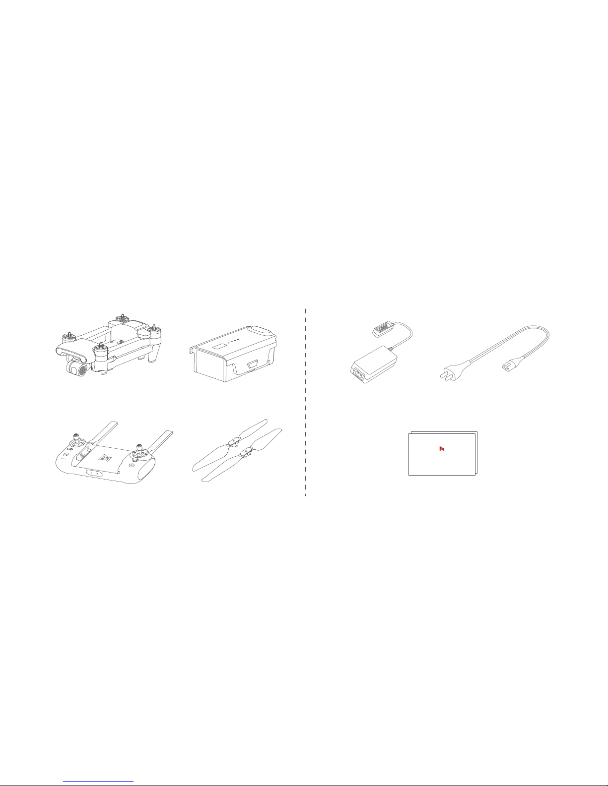
Package List
Remote contr oller x 1
Drone x 1
AC cable x 1
Instruct ion x 2
Batter y x 1
使用产品前请仔细阅读本快速入门指南,并妥善保管
FIMI X8 SE 无人机快速入门指南
Positive pr opeller x 3
Reverse propellerx 3
Charger x 1
Product Introduction
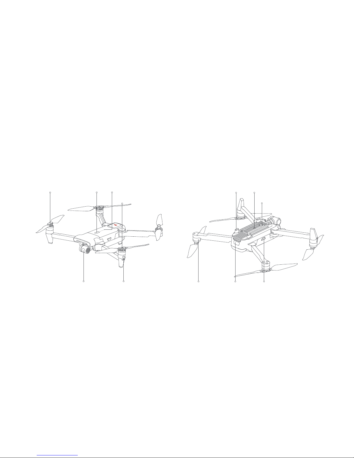
1 Drone
Integrated gimbal camera
Power but ton
Flight status indicator
Reverse propeller
Batter y level indicatorsPositive propeller
Drone tail indicator
Motor
Ultrasonic detecting m odule
Landing gear Optical flow camera
Batter y buckle
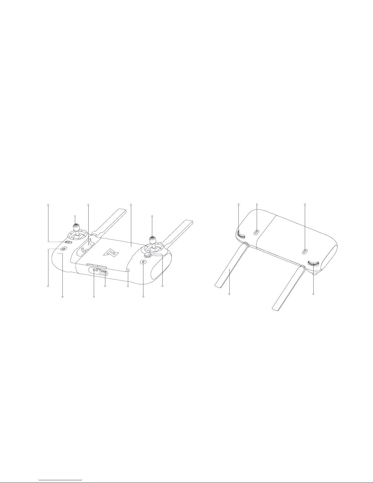
1 Remote controller
Power but ton
Auto take-of f/land button
Flight mode/auto retur n
Left stick
Stick storage slot
Five-directional button
Mobile device holder
Charging port
Right stick
Batter y level indicators
Cable slotUSB por t
Right dialAntenna
Left dial
Record button Shoot button

Drone
Flight Mode
GPS Mode (Standard)
GPS module is used to achieve precise hovering, and intelligent flight
function is supported in GPS mode. Users can enable Sport Mode or
Beginner Mode in the flight settings. When the Beginner Mode is on, the
flight speed, flight distance, flight altitude and RTH altitude will be limited.
In sport mode, The maximum flight speed is 18m/s, the maximum ascending
speed is 5m/s, and the maximum descending speed is 4m/s.
VPU Mode (Optical Flow)
Optical flow module is used to achieve precise hovering, and intelligent flight
function is not supported in VPU mode. The maximum flight speed is 10m/s,
the maximum ascend speed is 3m/s, and the maximum descending speed
is 2m/s. The drone, flying above bright ground with clear texture, will switch
to VPU mode automatically when GPS signal is poor.
ATTI Mode (Posture)
The drone enters ATTI mode under the condition of poor GPS signal or
compass interference. In ATTI mode, the drone will drift in the horizontal
direction and do not support the intelligent flight function. Therefore, in
case of an accident, the user should choose a location with good GPS
signal and open area to fly. Once the drone enters ATTI mode, please
land to a safe place as soon as possible.
Drone indicators
red green
yellow
Drone heading
Drone indicators
All indic ators are bre athing
All indic ators are f lashing twice
All indic ators are glaring
The yellow in diator is fl ashing
All indicato rs are on
The red and green indi cators are on and the
yellow indic ator is flashing at regular intervals
Drone status
Self-checking
Low battery aler ts
Batter y is low, land as soon as possible
Drone firmware is updating
Drone on the ground: self-check fails
Drone in the air: internal er ror
Ready to fly / in flight
1
2
3
4
5
6
Note: Spor t Mode is not available when the operational altitude up to 2400 meters.
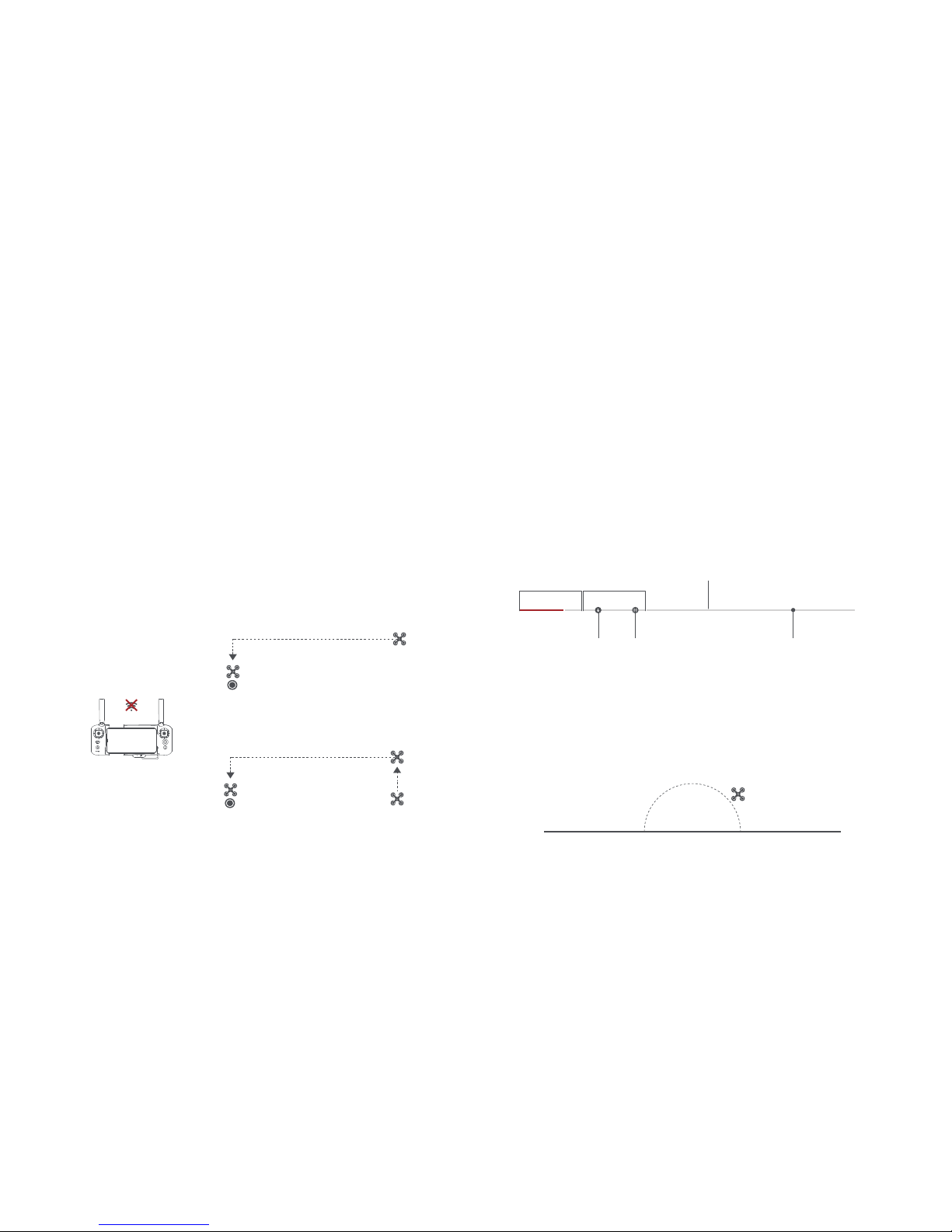
Safety Protection
Failsafe Return
Failsafe return is only supported in GPS mode. When the GPS signal is
good, the compass is working normally and the drone records the return
point successfully, if the wireless signal of the drone and the remote controller
is interrupted over 2 seconds , the flight control system will take over the
control of the drone and plan the return route according to the original flight
path, and the drone will fly back to the return point. If the drone and the
wireless remote controller signal is reconnected in the return process, the
user can turn off App return hint or re-toggle the auto return switching to
flight mode to cancel, and the drone will hover at the current position.
home point
home point
current altitude≥return altitude
ascend first
( the default altitude is 30m)
current altitude<return altitude
Low-power Protection
In flight, when the battery level is only enough for RTH, App advises users
to return, and the drone will return automatically after 10 seconds countdown.
When the bat tery level is only enough for landing, App advises users to land
as soon as possible, and the drone will land automatically after 10 seconds
countdown. When the battery level is at 10% usage left, the drone will be
forced to land.
Hovering on the Edge of No-fly-zone
The drone will automatically hover in the restricted flight area designated by
the state, such as the edge of airports, and the App will appear corresponding
hints. The user can use sticks to control the drone to evacuate from the edge
of no-fly-zone, but sticks cannot control the drone to fly into the no-fly-zone.
critical low battery
landing battery level
normal battery level
low battery
current battery levelRTH batter y level
15%10%0% 30%
100%
hover
No-fly-zone
Intelligent Flight
Auto Take-off
When the drone meets Auto Take-off conditions, long press auto take-off/land
button 2 seconds to take off. In GPS mode, the drone will take off to an
altitude of 4 meters and hover for sticks control. In VPU mode, the drone
will take of f to an altitude of 1.2 meters and hover for sticks control.
Auto Landing
When the drone meets auto landing conditions, long press auto take-off/land
button 2 seconds to land vertically.
Altitude
altitude <3m
distance<10m
altitude ≥3m
distance<10m
altitude ≥3 0m
distance≥10m
altitude ≤3 0m
distance≥10m
Distance
30m
3m
10m
home point
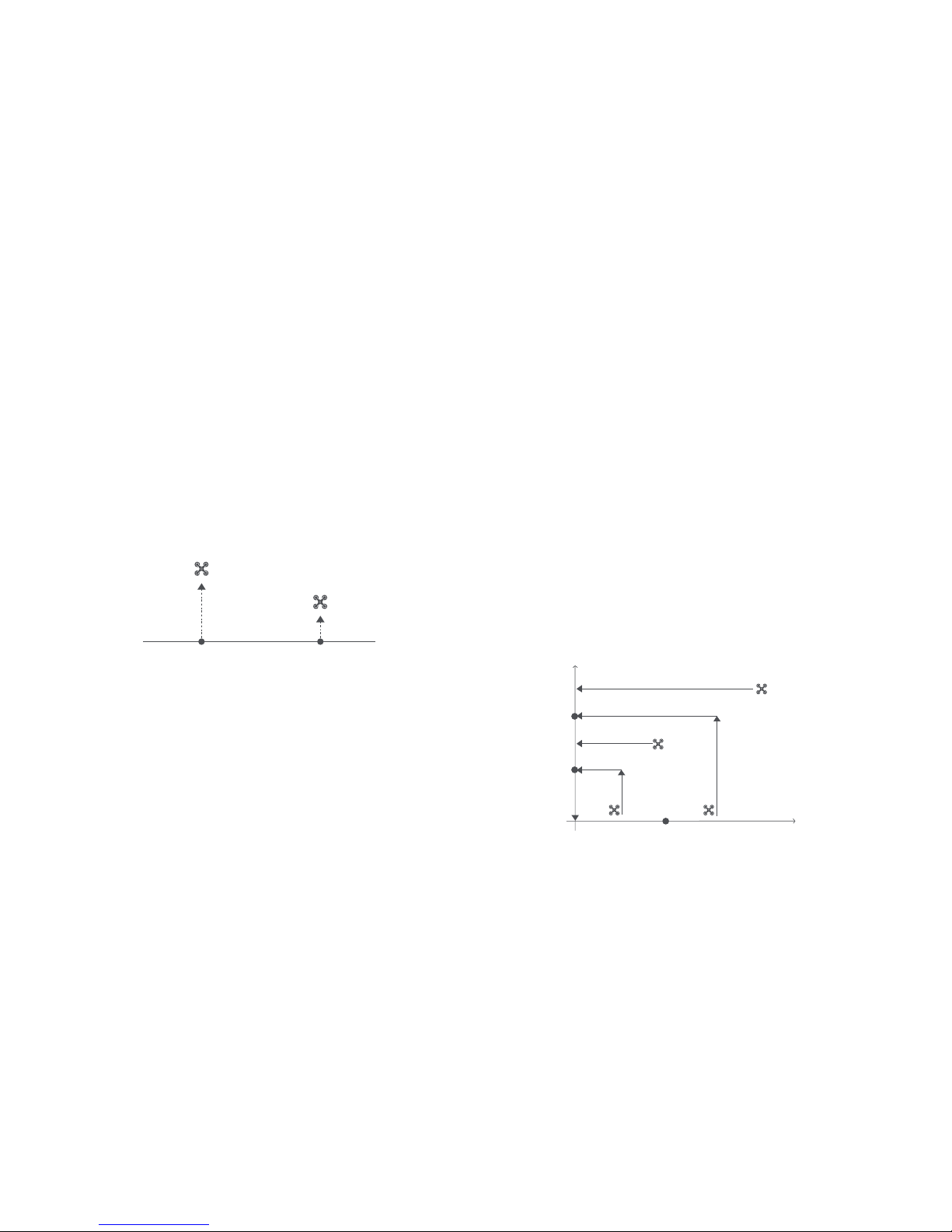
Auto Return
When the drone is in flight, the user can toggle the auto return switch to
the right to return the drone. When the return distance is less than 10
meters and f light altitude is less than 3 meters, the drone will ascend to
3 meters first and return to the home point; if the flight altitude is greater
than or equal to 3 meters, the drone will directly return to the home point
at the original altitude. When the return distance of the drone is greater
than or equal to 10 meters and the flight altitude is less than 30 meters,
the drone will ascend to 30 meters and return to the home point; if the
flight altitude is greater than or equal to 30 meters, the drone will directly
return to the home point for landing at the original altitude. The user can
toggle the auto return switch to the left to exit Auto Return.
GPS Mode VPU Mode
4m
1.2m
Note: Users can short press the auto take-of f/land button to exit intelligent flight.

Smart Track
Smart Track is supported only in GPS mode. The user can choose Trace,
Profile, or Lock in the App menu, the drone will trace the subject chosen at
the App interface at a distance.
In Trace mode, the heading will always lock at the target and trace it from the back
at a distance.
In Profile mode, the heading will always lock at the target and trace it from the
side at a distance.
moving dire ctionheading
moving direction
drone movin g direction
heading
camera tracking 3 60°
flight speed =0m/s
flight speed = 0m/s
In Lock mode, the drone will hover at a place with its heading trace its target
360-degree if the default speed is 0. The user can also adjust flight speed,
and the drone will fly around the target at a certain distance.
Note: In Smart Track, users should always make sure to avoid people, animals and
obstacles in the trac king path to ensure the flight safet y. Users should c omply with
local laws and regulat ions when using the function.

Dronie
The user can select Dronie,including Rocket and Invert,in the App. In Rocket
mode, the drone flies upward with the camera pointing downward at the
subject to shoot a video. In Invert mode, the drone flies backward and upward
with the camera locking at the subject to shoot a video.
Drag a rectangle around a POI
Set flight speed and altitude, the flight control center will estimate flight time
automatically
The drone automatically adjusts its place
3 seconds count down to fly away to shoot a video once the drone completes
adjustment
Orbit
The user can select Orbit mode in the App. When set a central point and
radius, the drone will fly around the central point at a default speed. If set
point of interest, the heading will be locked at the POI.
Fly to a central point to set the central point
Fly away from the central point to set radius
Set flight speed, move direction and heading. If the heading is free,the user can
drag a rectangle around a POI
If sticks are moved in flight, the flight altitude or radius will be changed. Taking
Mode 2 as example:
POI
Central point
Tap-f l y
The user can select Tap-fly in the App. Tap map to choose a destination
and set flight speed, the drone will fly over there at a default speed in a
straight line. If set point of interest, the heading will be locked at the POI
Tap map to choose a destination
Switch to image inter face to drag a rectangle around the POI
Set flight altitude and speed
POI
drone destination
Ascend
Descend
Radius zoom out
Radius zoom in
Counterclockwise
Clockwise Direction&Speed Direction&Speed
Left stick Right stick

pitch: -90°
target
fly vert ically upward
0°< pitch<90°
target
fly back wards and upwards
Rocket Invert
Spiral Mode
The user can select Spiral Mode in the App. Set the central point and
radius, the drone will spirally fly upward and shoot a video simultaneously,
showing a sense of space.
Fly to a point to set as the central point
Fly away the central point to set radius
Set spiral direction and flight distance to start and shoot a video at the same time
The mission interrupted if the user moves sticks
central po int
radius
Course Lock
The user can select Course Lock mode in the App. The drone saves current
fly direction as heading. The user can control sticks to adjust direction of
head and gimbal, but the forward direction remains unchanged.
Tripod Mode
The max speed of the drone is 1m/s, and the max rotation speed is 60°/s.
In Tripod Mode, operation sensitivity is lowered simultaneously to shoot
more stable and smooth video.
Aerial Mode
The brake distance is lengthened and the angular speed of rotation is
limited to make sure the shooting videos are more stable and smooth
Note: Course Lock is enabled in Aerial Mode, Users can turn it on in the APP
SAR Mode
The user can select SAR Mode in the APP. With real-time GPS coordinates,
the drone could help user to search and rescue.
Image inter face: show real-time c oordinate and time of the drone, support digital
zoom, screen shots to share online
Map inter face: show real-time coordinate and time of the drone in ordinary map
and satellite map, screen shots to share online

Waypoint
Choosing waypoint and drawing route both are available at map. The drone
flies along waypoint route at a default speed. If set point of interest, the
heading will be locked at the POI. The user can select a way to set waypoints,
including choosing points in flight or on the map, historial routes.
Choosing points in f light:
1. control the drone to a point to set as a waypoint
2. using sticks to set flight altitude and heading direction, dials to set gimbal angle, and
actions when reaching the waypoint
3. when all waypoints ready, please set waypoints routes attribute, incuding flight speed,
heading direction, action at the destination
4. POI is enabled when executing waypoints
Choosing points on the map
1. tap map to add waypoint
2. set waypoint attribute, including flight altitude, action at the destination, rotate direction
3. drag the POI icon to the map, and set its a;titude and relate waypoints
4. when all waypoints ready, please set flight speed, failsafe action, and action at the
destination
5. POI is enabled when exec uting waypoints
POI
Waypoint
heading
Precise Landing
In the process of Return to Home, the optical flow sensor will match landing
pad features above the home point. Once matched successfully, the drone
will land on the landing pad precisely.
Fix-wing Mode
In Fix-wing Mode, the drone can only fly for ward, not backward. The user can use
sticks to control flight speed and course as showed below (America Mode).
Left stick
Right stic k
push upward
push downward
toggle lef t
toggle right
push upward
push downward
toggle lef t
toggle right
down
up
turn lef t
turn right
accelerate
decelerate
turn lef t
turn right
Historical routes
1. preview the waypoints and its attr ibute by entering Favorite list
2. tap to start and show the real-time waypoints trace

Battery
The intelligent battery of FIMI X8 SE has a capacity of 4500mAh,
a voltage of 13.05V. This type of battery employs high energy cell,
advanced battery management system, and charge and discharge
functionality.
Assemble and disassemble
Push hard the battery, after the battery installed in place, there will be a
"click" sound.
To remove the battery, you need to press the battery buckle on both
sides of the batter y to pull out the battery.
Assembly and Disassembly
1 Propellers
Unfold the front and rear arms of the drone.
Attach the gray marked propellers to the motor mounting base with gray marks
on the arms.
Ensure the propeller is pressed to the bottom of the mounting base.
Rotate the propeller to the end of the lock direction until the propeller gets
bounced and locked.
Press the propeller forcefully and rotate the propeller along the unlock direction
to remove the propeller.
Safety tips:
If the propeller is damaged, please replace them to ensure flight safety
and efficiency.Check if the propeller is properly installed and fastened
before each flight.Stay away from the rotating propeller to avoid cutting.
Note: Take the installation of reverse propeller as an example.

Charging
Connect the battery,charger and AC cable as shown below, and
plug the charger into a power outlet
When the battery is in charge, the battery level indicators are flashing
When the battery is fully charged, the batter y level indicators go out
It takes about 2 hours to fully charge the battery
Turning on and off
Short press+long press power button 2 seconds to power on/off
Short press to check batter y level

Gimbal and Camera
Camera
The camera, equipped with 1/2.3 inch CMOS and wide-angle
lens with 26mm equivalent focal distance, supports 4K 30FPS
HD videos and 12megapixel photos to shoot a blockbuster easier.
It also owns various shooting modes, inculding single, burst, time
lapse, panorama shot and slow motion, for different scenario.
Drone TF card
When installing TF card to the drone,please unfold the arms of the drone
first and open the interface protection cover
Insert the TF card with the literal upward into the TF card slot
When removing TF card, press the TF card to pop out
RC
Note:Suppor t Micro SD ( U3 and above ) 8 ~ 64GB, recommend to use
Sandisk Extreme Pro V30 32G
Sandisk Extreme V30 32G
Samsung Pro Endurance 32G
Lexar Professional 1000X 32G
Sandisk Extreme Pro V30 64G
Sandisk Extreme V30 64G
Toshiba Exceria Pro 64G

Gimbal
FIMI X8 SE combines a light weight 3-axis mechanical gimbal
with the latest professional control algorithms and ±0.004°
control accuracy, which provides a stable shooting platform for
camera. The pitch axis, default to tilt from 0°to -90°, can be
adjusted by left dial of remote controller or App.
FPV Mode:
The roll axis rotates with the drone to provide
a first person view
-90°
0°
Horizon
Parallel
Follow Mode:
The roll axis does not move with the drone
and always keep the gimbal horizontally,
which suits for shooting stable videos
Operating Mode

Turning on and off
Short press+long press power button 2 seconds to power on/off
Short press to check battery level
Remote controller
With ergonomic design, it is easier and more precise to control.
There is no complicated operation to connect App, just plug
in and it works. The remote controller fully charged can work
about 4.5 hours.
5V 2A
Charge
.
.
.
.
Connect the remote controller to a power adapter as show below
When the RC is in charge, the battery level indicators are flashing
when the RC is fully charged, the battery level indicators go out
It takes about 4 hours to fully charge the RC in the powered off condition

Assemble Device
Shooting and Recording
Tighten the mobile or pad on mobile device holder by extending the holder
to the left.
Open the interface protection cover on the RC bottom.
Connect your phone and the RC with a USB cable.
Connect the drone and update firmware according to instructions in Fimi
Navi app.
Note: The cable slot is reserved on the right side of the RC.
Press the shoot button to take a photo. A photo is taken when you hear 2
short sounds.
Press the record button to record video. Recording starts when you
hear 2 short sounds. Press again to stop recording with 4 shor t sounds.
During recording, shor t press the shoot button to capture a picture.
( only support 1920x1080 25|30|50|60fps)
The pitch angle of the gimbal can be controlled by toggling the left dial
up and down. The right dial can adjust EV/ISO.
Record button
Shoot but ton

Shortcut Buttons
Push the five-directional button up default to access map or FPV
Push the five-directional button down default to gimbal center or down
Toggle the five-directional button lef t default to turn on/of f battery info interface
Toggle the five-directional button right default to turn on/of f self-check inter face
Press the f ive-directional button center default to turn on/off media
Toggle the auto return button to the lef t when the drone is in f light, the drone will
return to the home point.
In the process of auto return, toggle the auto return but ton to the left, the drone
will hover at place and wait for sticks instructions.
When auto take-off/land but ton turns white, it can be pressed to take off or land
When the drone meets auto take-of f conditions, long press 2 seconds to take off
When the drone meets auto land conditions,long press 2 seconds to land
When the drone is executing intelligent flight, shor t press this button to exit
Right dial to adjust EV/ISO value
Left dial to adjust pitch angle of gimbal

Sticks Control
Mode 1
Mode 2
Remote Controller Pairing
When a new remote controller or drone is replaced, please pair
the remote controller and the drone again as shown below:
Turn on the drone
Turn on the RC, long press the power button 15 seconds until hear ing
constant beep sound,and the power button red light flashes
Short press the code pairing button on the drone , the yellow indicator on the
drone goes out
The code pairing succeeds when the power button on the RC turns white
and the yellow indicator on the drone keeps on
RC
Forwar d
Backward
Up
Down
Co unter-
clockwise
Clockwise Left
Right
Left stick Right stick
Up
Down
Forwar d
Backward
Co unter-
clockwise
Clockwise Left
Right
Left stick Right stick
Mode 3
Forwar d
Backward
Up
Down
Co unter-
clockwise
Clockwise
Left stick Right stick
Left
Right
Remote indicators
Remote status
Weak signal or not connected to the drone
Auto take-off or landing not enabled
Ready for auto take-off
Normal signal
RC Pairing or upgrading firmware
Recording videos
1
2
3
4
5
6
Remote indicators
Power button's red light is on
Power button's white light is on
Power button's red light f lashes
Power button's white light flashes
Auto take-of f/landing button's
red light is on
Auto take-of f/landing button's
white light on

APP
Download and install Fimi Navi app, register a FIMI user
account before login, and select FIMI X8 SE to enter device
Image Interface
1. Real-time Flight Parameters
28.8m: ver tical flight altitude from the home point
32.8m: hor izontal distance from the home point
VS1.23m/s: vertical speed
HS1.80m/s: horizontal speed
: Estimated landing battery
: Estimated RTH battery
2. Drone Status
In flight: current flight status
GPS: current flight mode,including GPS,VPU,ATTI
: drone real-time power
3. Signal Status and General Settings
: show GPS signal status, 0-6 indicates poor with red; 7-12 indicates good with yellow;
13 and above indicate excellent with white. Tap to enter flight control settings
: show image transmission signal strength
: show the RC signal strength, tap to enter RC setting
: show real-time batter y level, tap to enter battery settings
: tap to enter settings
: Real-time estimated f light time
GPS
1
4 65 8 7
2 3

4. Map Interface
show the drone real-time location, tap to switch with image interface
5. Metering Mode
tap any place in the image interface for metering, when appearing exposure lock
button, click to lock the value.
6. Gimbal and Image Parameters
:Show the current gimbal angle
:Show the current EV value
:Show the current ISO value
:Show the current Shutter value
:Show current color mode
:Show the capacity of SD card and its residue
:Show video resolution and frame rate in video mode, or image size in photo mode
7. Camera Operation Area
3:26 :Video record length
:Camera parameter set tings, tap to set EV,ISO,shutter,video or photo mode,
resolution, video size, white balance, etc.
:Tap to switch between photo and video record
:Tap to start/stop shooting photos or record videos
:PIV button, only appear in video mode with 1080 P
:Media library, tap to download or preview videos and photos saved in
Micro SD c ard
8 Intelligent Flight
Tap to enter intelligent flight interface
:Auto Take-off
:Auto Landing
:Auto Return
:Waypoints
:Smart Track, including Trace, Profile, Lock
:O r b i t
:T a p - f l y
:Dronie,including Rocket and Invert
:Spiral Mode
:SAR Mode
:Aerial Mode
:Tripod Mode
:Course Lock
:Fix-wing Mode

Map Interface
:Tap to switch between drone position in the screen center or both drone
and phone position in the screen center
:Set current drone position as Home point
:Set current phone position as Home point
:Current drone position
:Home point
:Current phone position
Prepare to Fly
1 Confirm the drone heading
The direction of integrated gimbal camera is the drone heading.
Once the drone is turned on, the heading can be told by navigation
indicators.
The red light and the green light indicate the heading,and the yellow light
is the tail.
Safety tips: Always keep the tail pointed at the user to avoid direction misjudging.
red green
yellow
Drone heading

Ensure the battery level of the drone and the remote controller are fully
charged
Ensure propellers are assembled correctly and without any damage or
ageing
Ensure the camera lens is clean
Ensure TF card is inser ted
Check Before Taking off
Left stick
Right stick
Left stick
Right stick
Left stick
Right stick
Manual take off
Manual landing
Stop propellers in an emergency
Keep both sticks to the bottom inner still over 3 seconds, the propellers
start spinning
Release both sticks once propellers have been spinning, and firmly push
the left stick upward to take off the drone
During flight, release both sticks to hover
At any time during controlled flight, release the sticks and the drone will hover
automatically
Slowly move the left stick downward to
land the drone
Once the drone has landed, push and
hold the left stick down over 5 seconds,
the motors will stop
Safety tips: The drone has no waterproof function. Please be careful of landing environment.
Do not land on an inclined plane for safety.
Safety tips: Do not do the above operation during normal flight to avoid motors being
stopped in the air.
When motors can't properly turn off, please toggle the left stick to the
bottom inner in maximum range, and press Auto take-off/landing button
for 5 seconds simultaneously, the motors will stop.

Flying Condition Requirement
1. The drone is suitable for people above 18 years who have full civil capacity.
2. Make sure to keep some distance from people, animals, trees, vehicles
and buildings while using the drone. Please be careful when someone
approaches.
3. Keep away from airports, railways, highways, high-rise buildings, utility
poles and other dangerous environments when operating the drone.
4. Keep away from the areas with complex electromagnetic signals such
as communication base stations and high-power antennas when
operating the drone.
5. The flight altitude and distance of the drone corresponding to the take-
off point will be limited based on relevant regulations and policies.
6. Do not use this product at the place and time prohibited by regulations and
policies.
7. To protect the legitimate rights and interests of users, please follow the
product safety instructions when using.
8. Do not operate the drone in bad weather such as strong winds, rain, snow,
or fog.
9. Please operate the drone in a broad place with a good GPS signal.
10. It is suggested that user should make the first flight under the guidance
of an experienced pro.
Maintenance and Calibration
Remote Controller Calibration
Please try to calibrate the remote controller when you detect
inconsistencies between stick control and drone flying.
Select "RC Calibration" in the remote controller menu
Tap" Start" to calibrate the center, do not move sticks
Skip to sticks calibration once the center calibration succeed
Skip to dial calibration once the sticks calibration succeed
Note: Please turn off the power of the drone before calibrating the remote controller.
RC calibration is not available in f light
Compass Calibration
If the magnetic field changes, the compass needs to be recalibrated
to ensure flight safety. If the drone's compass needs to be calibrated,
the App will give corresponding hints and guidance. After entering
the flight control menu, please select "compass calibration", and
then calibrate based on prompts on the App.
Note: Please connect the drone before calibration. Compass calibration is not
available in flight.

Gimbal Calibration
Click "gimbal calibration" and enter the calibration page in
the gimbal settings menu.
After the drone is placed smoothly, click to start calibration.
Do not move the drone during the calibration process.
After the calibration is completed, the App interface shows
"Calibration succeed".
If the App interface shows "Calibration failed", please recalibrate.
Note: Gimbal calibration is not available in f light.
Propellers Maintenance
Propellers are wearing parts. When they're damaged, replace
them in time to ensure flight safety and efficiency.
Battery Maintenance
Do not throw the battery into fire; Do not batter the battery;
Lithium battery's capacity reduces significantly in low temperature
conditions. Do not use the battery when it is below 5 degrees.
Do not place the battery under the burning sun.
Gimbal Maintenance
The gimbal of X8 SE, integrated with the drone, does not need
to disassemble. Please be careful not to scratch the camera
when store the drone. Please keep the camera clean for better
image quality.
Drone Self-check
The drone enters the self-check when the drone is powered
on. If the self-check failed, App will pop up corresponding
hints.
Firmware Upgrade
Please check the firmware version regularly, new version will
be pushed by Fimi Navi App to prompt users to update.
Please download new firmware when the App is connected
with the drone and remote controller

Basic Specification
Drone
Product model:FMWRJ02A5
Dimensions:204×106×72.6mm
Diagonal size:372mm
Take off weight:About 786g
Flight time:About 3 3min*
Max ascending speed:5m/s
Max descending speed:4m/s
Max flight speed:18m/s
Satellite positioning systems:GPS/GLONASS
Hover accuracy:
Vertical:±0.1m (Within the ultrasonic detecting range)
±0.5m (when GPS positioning is active) Horizontal: ±1.5m
Operating temperature:0°C ~ 4 0°C
Suitable altitude:≤5000m
Operating frequency:5.725-5.85 0GHz
Charger
Rated input:10 0-240V~50/60Hz 1.5A
Rated output:13.05V 3A
Rated power:39.15W
Remote controller
Net weight:About 373g
Di mensi on s:20 3.8×9 1×46 .6m m
Operating frequency:5.725-5.85 0GHz
Type:Rechargeable lithium battery
Capacity:3900mAh
Nominal voltage:3.7V
Input:5 V 2A
Max transmission distance:About 5000m*
Operating temperature:0 ~ 40°C
Suitable altitude:≤5000m
Not e:
The 33 minu tes flight t ime refers to constant spee d at 7m/s (no wind) wit h fully charged and low c yclic batte ry. Remote contr ol distance reach to 5km (FC C) in open area and no interfe rence . All above testing and
data come f rom FIMI laboratory, err ors may occur in actual us e for operating and enviro nmental chan ges.
Battery
Type:Rechargeable lithium battery pack
Weight:About 275g
Capacity:4500mA h
Voltage:11.4V
Limit voltage:13.05V
Energy:51.3Wh
Charging ambient temperature:0°C ~ 40°C
Gimbal
Controllable rotat ion range:0 °~ -90°(Pitch)
Angular vibration range:± 0.004°
Lens:FOV 78.8°
Camera aperture:f2. 2
Camera focal distanc e:4.73mm
Equivalent focal distance:26mm
Sensor:1/2.3" CMOS
Effective pixels:12M
ISO range:100 - 3200(Video),100 - 1600(Photo)
Shutter sp eed:8 ~ 1/800 0s
Max video resolution:3840 x 2160 | 30fps | 25fps | 24fps
Max birate: 100Mbps
Max photo resolution:4000×3000
File system:FAT32 / exFAT
Image format:JPG,JPG+DNG
Video format:MP4
Memor y card type:Mic ro SD ( U3 and above ) 8 ~ 64GB
 Loading...