

Page 1
SG-959 GPS 接收器用户手册中文版 V1.1
SG-9
59GPS
接收器
接收器接收器
接收器
用户手册
SiRF StarⅢ
V 1.1
Ⅲ
ⅢⅢ
机密 规格书更改恕不作另行通知 著作权©2008 达伽马导航科技有限公司
台湾制造
台湾制造
台湾制造台湾制造
2008/08/08
service@dagamagps.com
www.dagamagps.com
免费服务热线(限中国大陆):400-820-1322
Page 2

1. 介 绍
介 绍
介 绍介 绍
SG-959 GPS 接收器用户手册中文版 V1.1
目目目目 录录录录
………… …………… …………… ……… ……….. …………. 2
1.1 概 述
1.2 产品特点
1.3 技术参数
2. 硬件
2.1 尺寸
2.2 数据接口
2.3 连接 头
3. 使用方法
概 述 ………… … …… ……… … …… … …… … …… … …… … … 2
概 述概 述
产品特点 ………………………………………………………………..… 2
产品特点产品特点
技术参数 ……………………………………………………………. 2
技术参数技术 参 数
硬件
硬件硬件
尺寸 .........………………………………………………………………. 4
尺寸尺寸
数据接口 ………………………………………………………..……… 4
数据接口数据接口
连接头 …………………………………………………………...…..… 5
连接头连接头
使用方法
使用方法使用方法
….............………………………………………………………… 4
…………………………………………………………………… 7
3. 1
3.2 开始
3.3 使用
3.4 功能
3.5 导 航
4. 售后服务条例
附 录
附 录 :::: 软 件 规 格
附 录附 录
U S B
U S B 驱 动 安 装 及
驱 动 安 装 及 C o m
U S BU S B
驱 动 安 装 及驱 动 安 装 及
开始 …………….…………………………………………………………. 11
开始开始
使用GPS Viewer测试设备
使用使用
功能 ………………………………………………………………… 12
功能功能
导航 …..…………………………………………………………….. 12
导航导航
售后服务条例
售后服务条例售后服务条例
软 件 规 格
软 件 规 格软 件 规 格
C o m 口 搜 索
口 搜 索
C o mC o m
口 搜 索口 搜 索
测试设备 ……………………………………………… 12
测试设备测试设备
……………………………………………….………… 12
… . . … … …… …… … …… … …… … …… … …. . . 1 3
…… … … … … …. . …… … …… … … … 7
机密 规格书更改恕不作另行通知 著作权©2008 达伽马导航科技有限公司
1/21
Page 3

SG-959 GPS 接收器用户手册中文版 V1.1
1. 介绍
介绍
介绍介绍
1.1 概述
概述
概述概述
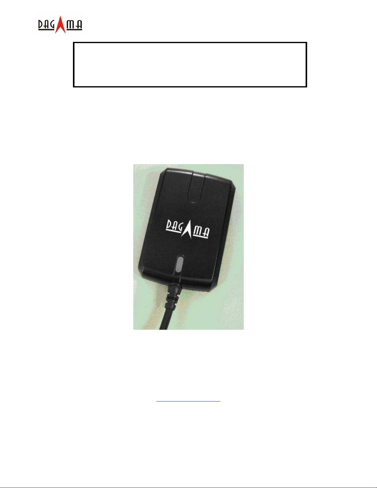
Dagama SG-959 GPS 接收器采用低噪声、高灵敏度、低功耗 SiRF StarIII 芯片,外观为紧凑型防
水设计。该产品非常适合车辆导航、绘图、测量等应用方向。只需要有稳定的供电和开阔的天空
即可正常工作。可通过 RS-232 串口或者通用 USB 接口与其他主设备通信。采用了低功耗的技术,
接收器可同时跟踪接收 20 颗卫星并且具有极快的 TTFF(首次定位时间)、重捕获小于 1 秒(平
均值),数据更新时间为 1 秒 1 次。
1.2 产品特点
产品特点
产品特点产品特点
SG-268功能多样、技术领先,方便整合、易于使用。
1. 采用 SiRF StarⅢ 高灵敏度GPS接收芯片。
2. 高灵敏度同时跟踪多达 20 颗卫星。
3. 紧凑型的高集成度的设计方案,占用最小空间。
4. 内置备份电池,用于支持内部时钟和数据存储。
5. 无须用户进行初始化。
6. 防水设计,全天候工作。
7. 内置高性能、低噪声GPS接收天线。
8. LED灯指示定位状态。
9. 支持标准 NMEA-0183 数据协议和SiRF二进制码。
1.3 技术参数
技术参数
技术参数技术参数
概述
概述
概述概述
频率 L1, 1575.42 MHz
C/A 码 1.023 MHz
通道数 20 通道
天线 内置
机密 规格书更改恕不作另行通知 著作权©2008 达伽马导航科技有限公司
2/21
Page 4

灵敏度
灵敏度
灵敏度灵敏度
获取 -159 dBm(典型值)
精度
精度
精度精度
位置 正常定位 5-25 m,无 SA 干扰
垂直精度< 5 m,WAAS/EGNOS 修正后(95%)
水平精度< 2 m,WAAS/EGNOS 修正后(95%)
时间 1 微妙(与 GPS 时间同步后)
坐标系统
坐标系统
坐标系统坐标系统
默认 WGS-84
定位速度
定位速度 (开阔天空
定位速度定位速度
开阔天空)
开阔天空开阔天空
热启动 1 s, 平均值
温启动 38 s, 平均值
冷启动 42 s, 平均值
再捕获 0.1 s, 平均值
动态
动态
动态动态
高度 < 18,000 m (60,000 英尺)
速度 < 515 m/s (1,000 节)
加速度 < 4 G
SG-959 GPS 接收器用户手册中文版 V1.1
功耗
功耗
功耗功耗
输入电压 5.0 ±5% V 直流
供电电流 80 mA @5V
串口
串口
串口串口
通信接口 支持 RS232/TTL 通信
通信协议 NMEA-0183, SiR 二进制码
默认 NMEA GGA, GSA, GSV, RMC, (VTG, GLL, and ZDA 可选)
4800 波特率 (其他波特率可选).
8 位数据位, 1 位停止位, 无校验码
重量
重量 < 85 g
重量重量
环境特性
环境特性
环境特性环境特性
工作温度 -40oC ~ +80oC
存储温度 -45oC ~ +95oC
机密 规格书更改恕不作另行通知 著作权©2008 达伽马导航科技有限公司
3/21
Page 5
SG-959 GPS 接收器用户手册中文版 V1.1
2. 硬件
硬件
硬件硬件
2.1 尺寸
尺寸
尺寸尺寸
该产品尺寸为: 59.7 mm (长) x 39 mm (宽) x 16.4 mm (高)
2.2 数据接口
数据接口
数据接口数据接口
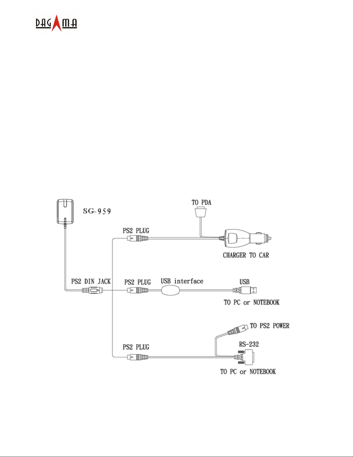
SG-959 GPS 接收器为系列产品,主要区别就是输出接头,分别描述如下:
SG-959
SG-959 带有带一个 PS2 输出接头。下图介绍了各种不同种类的连接组件。一体化的点烟器电源
适配器可通过车载点烟器供电。将连接组件的 PS2 接头一端连接至 SG-959,另一端可连接至您
的 PDA。对于笔记本电脑用户,必须具有一个 PS2 至 USB 的连接组件,这是可选配件。连同该
组件会随机配备一张 USB 驱动 CD。另有适合电脑或笔记本的 RS232 接口的连接器可供选配。
机密 规格书更改恕不作另行通知 著作权©2008 达伽马导航科技有限公司
4/21
Page 6
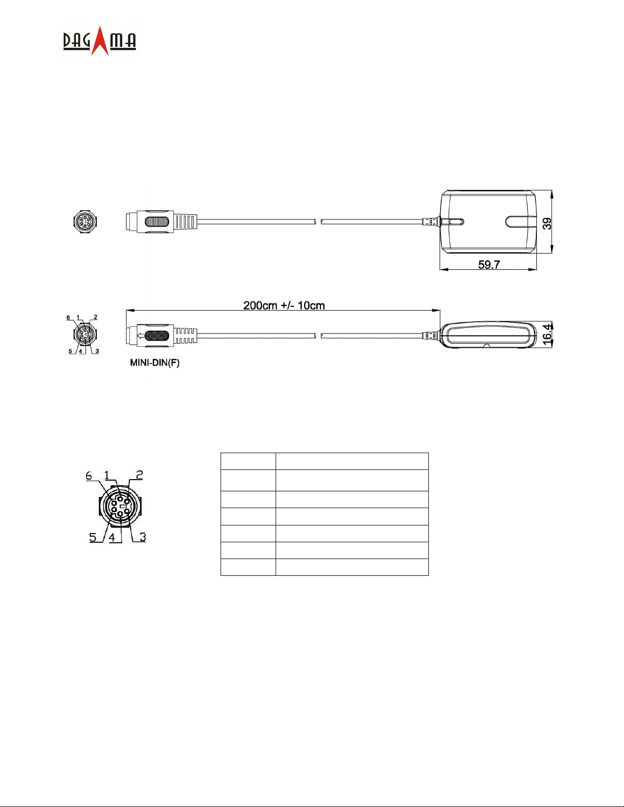
2.3 连接头
连接头
连接头连接头
以下为输出接头的描述:
SG-959
标准连接电缆含 PS2(母头)接头,长 2 米,如下图:
SG-959-PS2
SG-959 GPS 接收器用户手册中文版 V1.1
标准 PS2 连接头的 pin 脚定义如下图和表格所示:
Pin 信号
1 输出 (RS-232)
2 +5VDC
3 输出 (TTL)
4 接地
5 输入(TTL)
6 输入(RS-232)
附件是一根 Y 型电缆,带有车载点烟器电源适配器,请参照上页图示说明。Y 型电缆一端是 PS2
接头用以连接 SG-959,另一端是用来连接 PDA。然而,因为 PDA 的种类各种各样,具体的适
配器类型须确定后方可使用。
对于电脑用户,可采用上页所示的 USB 接头或 RS232 转接线。USB 接头的驱动程序会在随机 CD
中提供,这些都是可选配件。
机密 规格书更改恕不作另行通知 著作权©2008 达伽马导航科技有限公司
5/21
Page 7
SG-959 GPS 接收器用户手册中文版 V1.1
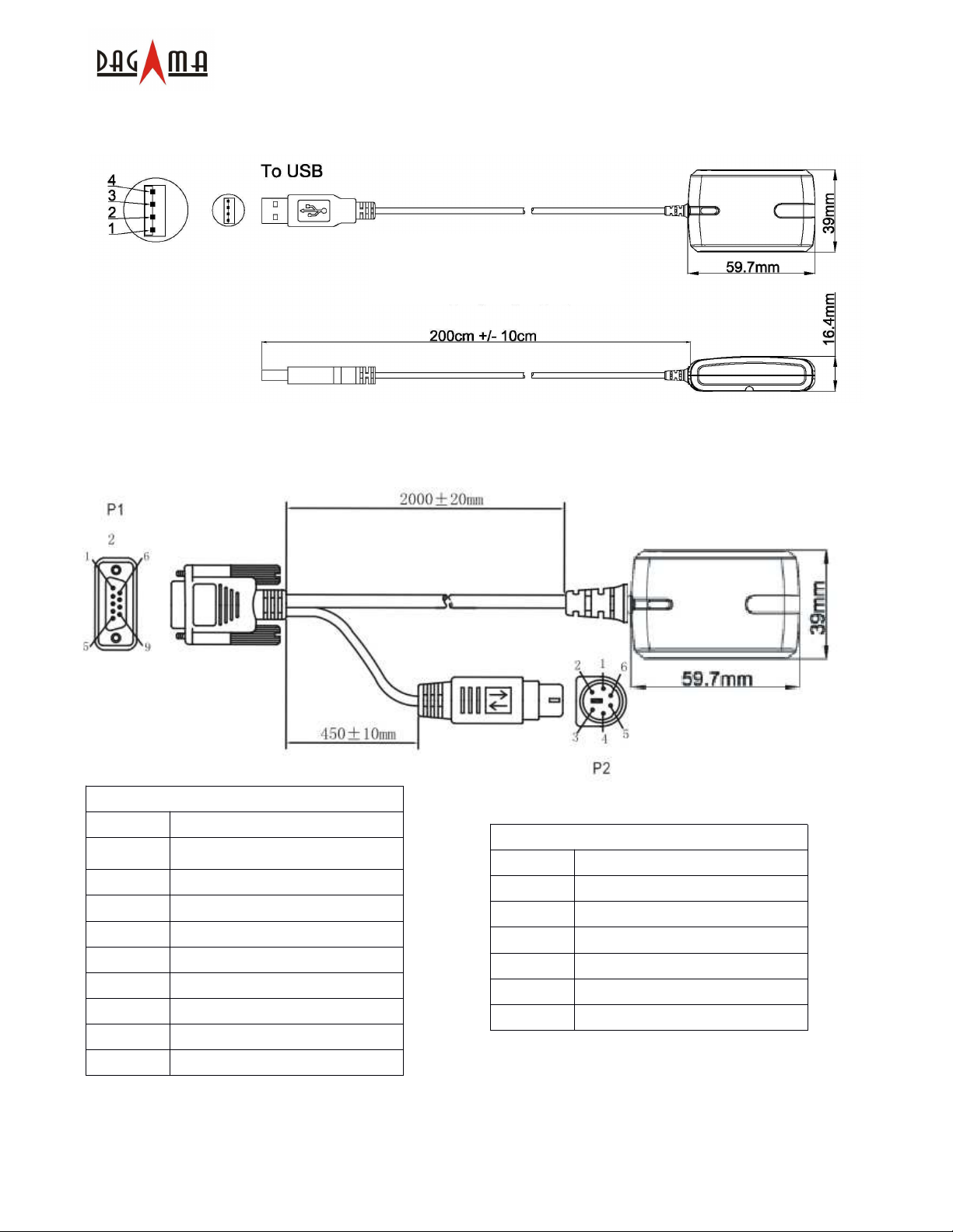
SG-959-USB
SG-959USB 为电脑用户提供了非常方便的解决方案。此连接头为标准 USB 接口。
SG-959-USB
SG-959-RS232
SG-959-RS232 为电脑用户提供了另一方便的解决方案。接头 pin 脚定义如下:
P1 Pin 脚定义
Pin 信号
1 NC
2 输出(RS232)
3 输入(RS232)
4 NC
5 接地
6 NC
7 NC
8 NC
9 NC
机密 规格书更改恕不作另行通知 著作权©2008 达伽马导航科技有限公司
6/21
P2 Pin 脚定义
Pin 信号
1 +5VDC
2 NC
3 NC
4 接地
5 NC
6 NC
Page 8

3. 使用方法
使用方法
使用方法使用方法
SG-959 GPS 接收器用户手册中文版 V1.1
3.1 USB 驱动安装及
对于使用USB型接头的SG-959 GPS接收器,需首先安装驱动程序。以WinXP操作系统为例,请
先插入驱动CD到光驱中。浏览CD内容,找到 “USB Driver” 文件夹。
驱动安装及 Com 口搜索
驱动安装及驱动安装及
口搜索
口搜索口搜索
打开文件夹,双击“PL-2303” 驱动图标,开始安装。点击安装欢迎界面的 “Next” 按钮进入下
一步。
机密 规格书更改恕不作另行通知 著作权©2008 达伽马导航科技有限公司
7/21
Page 9

SG-959 GPS 接收器用户手册中文版 V1.1
安装完毕后,点击 “Finish” 按钮结束安装程序。
机密 规格书更改恕不作另行通知 著作权©2008 达伽马导航科技有限公司
8/21
Page 10

SG-959 GPS 接收器用户手册中文版 V1.1
现在,您可以插入 USB 接头到您的电脑上了。为了正确接收 GPS 数据,您还需设置好正确的端
口号和波特率。下面介绍如何确定 USB 接头的端口号。点击操作系统的“
“开始
““
板板板板”””” 。。。。
开始”””” → ““““控制面
开始开始
控制面
控制面控制面
双击““““系统
点击““““硬件
系统”””” 图标进入““““系统属性
系统系统
硬件””””标签,找到“设备管理器
硬件硬件
系统属性”””” 窗口。
系统属性系统属性
设备管理器””””按钮。
设备管理器设备管理器
机密 规格书更改恕不作另行通知 著作权©2008 达伽马导航科技有限公司
9/21
Page 11

SG-959 GPS 接收器用户手册中文版 V1.1
点击此按钮后Windows将显示硬件状态。找到“
“端口
端口(Com 和和和和 LTP)””””项然后查找Com口列表中
““
端口端口
的“Prolific USB-to-Serial Com Port (COMxx)”,xx 即为您所连接到的端口号。
尽管以上安装步骤是针对WinXP系统的,但其他Windows系统中的安装步骤也基本上是类似的。
机密 规格书更改恕不作另行通知 著作权©2008 达伽马导航科技有限公司
10/21
Page 12

SG-959 GPS 接收器用户手册中文版 V1.1
3.2 开始
开始
开始开始
用合适的连接组件连接好 SG-959 GPS 接收器,具体取决于电源和主设备类型。如果采用USB
接口的请先安装USB驱动程序。
将GPS接收器放置在天空开阔的地方,红色
(a) LED 常亮——电源已接通,正在设备初始化;
(b) LED 每隔0.5秒闪烁一次——接收器已定位,开始输出位置信息。
3.3 用用用用GPS Viewer软件测试设备
在主设备上安装GPS Viewer软件后,您就可以随时查看GPS接收器的工作状态了。以下是标准按
钮和操作步骤:
(a) 运行GPS Viewer程序,点击 “Com Port”和“Baudrate” 按钮设置端口号和波特率(4800);
(b) 点击 “OPEN” 按钮下载接收器传来的数据,通常,一个窗口显示NMEA格式数据流,另一
个窗口显示卫星信号强度;
(c) 连接建立后,点击 “CLOSE” 按钮可以中止程序。您还可以点击其他按钮执行相应的功能。
软件测试设备
软件测试设备软件测试设备
红色LED灯指示以下状态:
红色红色
3.4 功能
功能
功能功能
电源打开后,SG-959 GPS接收器即马上开始卫星信号跟踪接收过程。正常环境下,42秒(平均
值)可以完成首次定位过程。定位后,相关的定位信息——有效位置、速度及时间将通过输出通
机密 规格书更改恕不作另行通知 著作权©2008 达伽马导航科技有限公司
11/21
Page 13

SG-959 GPS 接收器用户手册中文版 V1.1
道对外传输。SG-959 GPS接收器利用各种原始数据,如上次定位点位置、日期、时间及卫星轨
道数据等可以实现最优异的性能。如果在原始数据中存在重大误差或卫星轨道数据过期,可能需
要更多时间才能定位。
3.5 导航
导航
导航导航
定位完成后,SG-959 GPS接收器将通过输出通道对外发送有效的导航信息。包括:
1) 纬度/经度/高度
2) 速度
3) 日期/时间
4) 卫星和接收器状态
4. 售后服务条例
售后服务条例
售后服务条例售后服务条例
此 GPS 接收器具有 1 年免费保修期(自购买之日起算),在保修期内,任何品质及功能方面的故
障都可以享受免费保修服务。自购买之日起 15 日内到我公司网站进行注册,可获得延长保修期90
天的免费增值服务。
出现以下情况时售后服务条例失效
出现以下情况时售后服务条例失效::::
出现以下情况时售后服务条例失效出现以下情况时售后服务条例失效
1. 产品序列号标签脱落、损坏或被修改。
2. 由意外事故、不正确的使用方法、用户疏忽、火灾、洪灾、闪电或其他自然因素、未经授
权的更改及未遵循随机的使用说明书导致的产品损害、性能衰退或故障。
3. 任何未经 Dagama 授权的维修或尝试维修行为。
4. 使用未经 Dagama 认可的配件。
机密 规格书更改恕不作另行通知 著作权©2008 达伽马导航科技有限公司
12/21
Page 14

SG-959 GPS 接收器用户手册中文版 V1.1
附录
附录::::软件规格
附录附录
软件规格
软件规格软件规格
NMEA Protocol
The SG-959 interface protocol is based on the National Marine Electronics Association (NMEA)
interface specification, namely, the NMEA 0183 standard. The SG-959 is capable of supporting
following NMEA message formats specifically developed and defined by SiRF.
NMEA Message Prefix Format Direction
$GPGGA Time, position and fix type data. Out
$GPGLL Latitude, longitude, time of position fix and status. Out
$GPGSA GNSS DOP and active satellites Out
$GPGSV Satellites in view. Out
$GPMSS
$GPRMC Recommended minimum specific GNSS data. Out
$GPVTG Speed and course over ground. Out
$GPZDA Date and time. Out
Radio beacon signal-to-noise ratio, signal strength,
Out
frequency, etc.
General NMEA Format
The general NMEA format consists of an ASCII string commencing with a ‘$’character and
terminating with a <CR><LF> sequence. NMEA standard messages commence with ‘GP’then a
3-letter message identifier. The message header is followed by a comma delimited list of fields
optionally terminated with a checksum consisting of an asterix ‘*’and a 2 digit hex value
representing the checksum. There is no comma preceding the checksum field. When present,
the checksum is calculated as a bitwise exclusive of the characters between the ‘$’ and ‘*’. As an
ASCII representation, the number of digitsin each number will vary depending on the number and
precision, hence the record length will vary. Certain fieldsmay be omitted if they are not used, in
which case the field position is reserved using commas to ensure correct interpretation of
subsequent fields.
机密 规格书更改恕不作另行通知 著作权©2008 达伽马导航科技有限公司
13/21
Page 15

SG-959 GPS 接收器用户手册中文版 V1.1
Range
0to12.
DGPS
is
not
used.
$GPGGA
This message transfersglobal positioning system fix data. Following isan example.
$GPGGA,161229.487,3723.2475,N,12158.3416,W,1,07,1.0,9.0,M, , , ,0000*18
The $GPGGA message structure isshown below:
Field Example Unit Notes
Message ID $GPGGA GGA protocol header.
UTC Time 161229.487 hhmmss.sss
Latitude 3723.2475 ddmm.mmmm
N/S Indicator N N=north or S=south.
Longitude 12158.3416 dddmm.mmmm
E/W indicator W E=east or W=west.
0: Fix not available or invalid.
1: GPS SPS mode, fix valid.
Position Fix Indictor 1
2: Differ. GPS, SPS mode, fix valid
3-5: Not supported.
6:
Dead Reckoning Mode, fix valid.
Satellites Used 07
Number of satellites used to calculate fix.
HDOP 1.0 Horizontal Dilution of Precision.
MSL Altitude
(2)
9.0 Meter Altitude above mean seal level.
Units M Meter M stands for “meters”.
Geoid Separation
(2)
Meter Separation from Geoids can be blank.
Units Meter M stands for “meters”.
Age of Diff. Corr. Second
Age in seconds. Blank (Null) fields when
Diff Ref. Station ID 0000
Checksum *18
<CR> <LF> Message terminator.
(1)
Only apply to NMEA version 2.3 (and later) in this NMEA message description.
(1)
(2) SiRF does not support geoid corrections. Values are WGS84 ellipsoid heights.
机密 规格书更改恕不作另行通知 著作权©2008 达伽马导航科技有限公司
14/21
Page 16

SG-959 GPS 接收器用户手册中文版 V1.1
$GPGLL
This message transfersgeographic position, latitude, longitude, and time. Following is an
example.
$GPGLL,3723.2475,N,12158.3416,W,161229.487,A,A*41
The $GPGLL message structure isshown below:
Field Example Unit Notes
Message ID $GPGLL GLL protocol header.
Latitude 3723.2475 ddmm.mmmm
N/S Indicator N N=north or S=south.
Longitude 12158.3416 dddmm.mmmm
E/W indicator W E=east or W=west.
UTC Time 161229.487 hhmmss.sss
Status A A:Data valid or V:Data invalid.
Mode A
Checksum *41
<CR><LF> Message terminator.
A=Autonomous, D=DGPS, E=DR
(Only present in NMEA version 3.00).
机密 规格书更改恕不作另行通知 著作权©2008 达伽马导航科技有限公司
15/21
Page 17

SG-959 GPS 接收器用户手册中文版 V1.1
1
2
3
$GPGSA
This message transfersDOP and active satellites information. Following is an example.
$GPGSA,A,3,07,02,26,27,09,04,15, , , , , ,1.8,1.0,1.5*33
The $GPGSA message structure isshown below:
Field Example Unit Notes
Message ID $GPGSA GSA protocol header.
M: Manual, forced to operate in selected 2D
Mode A
Mode 3
or 3D mode.
A: Automatic switching between modes.
Fix not available.
2D position fix.
3D position fix.
Satellites Used
Satellites Used
(1)
(1)
07 SV on channel 1.
02 SV on channel 2.
… ..
Satellites Used
(1)
SV on channel 12.
PDOP 1.8
HDOP 1.0
VDOP 1.5
Checksum *33
<CR> <LF> Message terminator.
(1) Satellites used in solution.
机密 规格书更改恕不作另行通知 著作权©2008 达伽马导航科技有限公司
16/21
Page 18

SG-959 GPS 接收器用户手册中文版 V1.1
$GPGSV
This message transfersinformation about satellitesin view. The $GPGSV message structure is
shown below. Each record contains the information for up to 4 channels, allowing up to 12
satellites in view. In the final record of the sequence the unused channel fields are left blank with
commas to indicate that a field has been omitted. Following isan example.
$GPGSV,2,1,07,07,79,048,42,02,51,062,43,26,36,256,42,27,27,138,42*71
$GPGSV,2,2,07,09,23,313,42,04,19,159,41,15,12,041,42*41
The $GPGSV message structure isshown below:
Field Example Unit Notes
Message ID $GPGSV GSA protocol header.
Number of messages
Message number 1 Sequence number, range 1 to 3.
Satellites in view 07 Number of satellites currently in view.
(1)
2 Number of messages, maximum 3.
Satellite ID 07 Channel 1, ID range 1 to 32.
Elevation 79 degree Elevation of satellite, maximum 90.
Azimuth 048 degree Azimuth of satellite, range 0 to 359.
SNR (C/N0) 42 dBHz Range 0 to 99, null when not tracking.
Satellite ID 02 Channel 2, ID range 1 to 32.
Elevation 51 degree Elevation of satellite, maximum 90.
Azimuth 062 degree Azimuth of satellite, range 0 to 359.
SNR (C/N0) 43 dBHz Range 0 to 99, null when not tracking.
Satellite ID 26 Channel 3, ID range 1 to 32.
Elevation 36 degree Elevation of satellite, maximum 90.
Azimuth 256 degree Azimuth of satellite, range 0 to 359.
SNR (C/N0) 42 dBHz Range 0 to 99, null when not tracking.
Satellite ID 27 Channel 4, ID range 1 to 32.
Elevation 27 degree Elevation of satellite, maximum 90.
Azimuth 138 degree Azimuth of satellite, range 0 to 359.
SNR (C/N0) 42 dBHz Range 0 to 99, null when not tracking.
Checksum *71
<CR> <LF> Message terminator.
(1) Depending on the number of satellites tracked multiple messages of GSV data may be required.
机密 规格书更改恕不作另行通知 著作权©2008 达伽马导航科技有限公司
17/21
Page 19

SG-959 GPS 接收器用户手册中文版 V1.1
multi-channel
beacon
receiver
is
used
.
$GPMSS
This message transfersinformation about radio beacon signal-to-noise ratio, signal strength,
frequency, etc. Following isan example.
$GPMSS,55,27,318.0,100,1,*57
The $GPMSS message format isshown below.
Field Example Unit Notes
Message ID $GPMSS MSS protocol header.
Signal Strength 55 dB SS of tracked frequency.
Signal-to-Noise Ratio 27 dB SNR of tracked frequency.
Beacon Frequency 318.0 kHz Currently tracked frequency.
Beacon Bit Rate 100 Bits per second.
Channel Number
(1)
1
The channel of the beacon being used if a
Checksum *57
<CR> <LF> Message terminator.
(1)
Fields marked in italic red apply only to NMEA version 2.3 (and later) in this NMEA message description.
机密 规格书更改恕不作另行通知 著作权©2008 达伽马导航科技有限公司
18/21
Page 20

SG-959 GPS 接收器用户手册中文版 V1.1
Status
AA:Data
validorV:
Data
invalid.
$GPRMC
This message transfersrecommended minimum specific GNSS data. Following is an example.
$GPRMC,161229.487,A,3723.2475,N,12158.3416,W,0.13,309.62,120598, ,*10
The $GPRMC message format isshown below.
Field Example Unit Notes
Message ID $GPRMC RMC protocol header.
UTC Time 161229.487 hhmmss.sss
Latitude 3723.2475 ddmm.mmmm
N/S Indicator N N=north or S=south.
Longitude 12158.3416 ddmm.mmmm
E/W indicator W E=east or W=west.
Speed over ground 0.13 knot Speed over ground
Course over ground 309.62 degree Course over ground
Date 120598 ddmmyy, current date.
Magnetic variation
(2)
Mode
Checksum *10
<CR> <LF> Message terminator.
(1) SiRF does not support magnetic declination. All “course over ground” data are geodetic WGS84 directions.
(2)
Fields marked in italic red apply only to NMEA version 2.3 (and later) in this NMEA message description.
(1)
A A=Autonomous, D=DGPS, E=DR.
degree Not used.
机密 规格书更改恕不作另行通知 著作权©2008 达伽马导航科技有限公司
19/21
Page 21

SG-959 GPS 接收器用户手册中文版 V1.1
$GPVTG
This message transfersvelocity, course over ground, and ground speed. Following isan example.
$GPVTG,309.62,T, ,M,0.13,N,0.2,K,A*23
The $GPVTG message format isshown below.
Field Example Unit Notes
Message ID $GPVTG VTG protocol header.
Course (true) 309.62 degree Measured heading
Reference T T = true heading
Course (magnetic) degree Measured heading
Reference
(1)
M M = magnetic heading
Speed 0.13 knot Speed in knots
(1)
Units N N = knots
Speed 0.2 km/hr Speed
Units K K = km/hour.
(2)
Mode
A A=Autonomous, D=DGPS, E=DR.
Checksum *23
<CR> <LF> Message terminator.
(1) SiRF does not support magnetic declination. All “course over ground” data are geodetic WGS84 directions.
(2)
Fields marked in italic red apply only to NMEA version 2.3 (and later) in this NMEA message description.
机密 规格书更改恕不作另行通知 著作权©2008 达伽马导航科技有限公司
20/21
Page 22

$GPZDA
This message transfersUTC Time and Date. Following isan example.
$GPZDA,181813,14,10,2003,00,00*4F
The $GPZDA message format isshown below.
Field Example Unit Notes
Message ID $GPZDA ZDA protocol header.
SG-959 GPS 接收器用户手册中文版 V1.1
UTC Time 181813
UTC Day 14 01 to 31, day of month.
UTC Month 10 01 to 12.
UTC Year 2003 1980 to 2079.
Local zone hours 00 Offset from UTC (set to 00).
Local zone minutes 00 Offset from UTC (set to 00).
Checksum *4F
<CR> <LF> Message terminator.
Either using valid IONO/UTC or estimated
from default leap seconds.
以上内容如有更新
以上内容如有更新,,,,以本公司最终版本为准
以上内容如有更新以上内容如有更新
以本公司最终版本为准,,,,恕不另行通知
以本公司最终版本为准以本公司最终版本为准
恕不另行通知!!!!
恕不另行通知恕不另行通知
All Rights Reserved
机密 规格书更改恕不作另行通知 著作权©2008 达伽马导航科技有限公司
21/21
 Loading...