


2006 Mid-Size Truck Navigation System M
Overview
Overview
Features and Controls
Features and Controls
........................................................ 1-1
.................................................. 1-2
..................................... 2-1
................................ 2-2
Navigation Audio System
Navigation Audio System
................................................................ 1
Index
................................ 3-1
............................ 3-2

GENERAL MOTORS, GM, BUICK, the BUICK Emblem,
CHEVROLET, the CHEVROLET Emblem, GMC, and the
GMC TRUCK Emblem, and the names TRAILBLAZER,
TRAILBLAZER EXT, ENVOY, and DENALI are
registered trademarks; and the name RAINIER
is a trademark of General Motors Corporation.
The information in this manual supplements the owner
manual. This manual includes the latest information
available at the time it was printed. We reserve the right
to make changes in the product after that time without
notice. For vehicles first sold in Canada, substitute the
name General Motors of Canada Limited for Buick Motor
Division, Chevrolet Motor Division, and GMC whenever it
appears in this manual.
Keep this manual with the owner manual in the vehicle,
so it will be there if it is needed. If the vehicle is sold,
leave this manual in the vehicle.
Canadian Owners
For Canadian owners that would like to obtain a French
language manual, see “Canadian Owners” in the Index of
your vehicle’s owner manual.
Litho in U.S.A.
Part No. 15263013 B Second Printing
ii
©
2005 General Motors Corporation. All Rights Reserved.

Section 1 Overview
Overview .........................................................1-2
Navigation System Overview ............................1-2
Getting Started ...............................................1-4
Cleaning the Video Screen ..............................1-9
1-1
Overview
Navigation System Overview
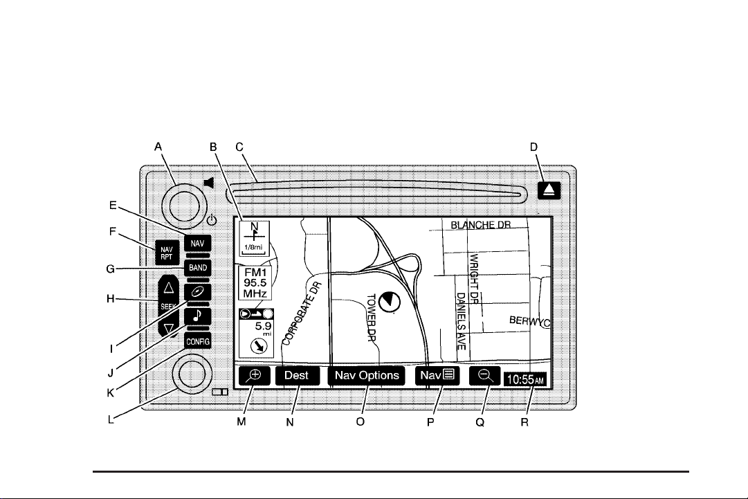
1-2

A. P (Power/Volume) Knob. See “Hard Keys” under
Using the Navigation System on page 2-2.
B. Directional Indicator. See Symbols on page 2-6.
C. DVD/CD Loading Slot
D.
X (DVD/CD Eject) Key
E. NAV (Navigation) Key. See “Hard Keys” under Using
the Navigation System on page 2-2.
F. NAV RPT (Navigation Repeat) Key. See “Hard
Keys” under Using the Navigation System on
page 2-2.
G. BAND Key. See “Playing the Radio” under
Navigation Audio System on page 3-2.
H.
w SEEK x Key. See “Finding a Station” under
Navigation Audio System on page 3-2.
B (CD) Key. See “Playing a CD” under Navigation
I.
Audio System on page 3-2.
e (Audio) Key. See Navigation Audio System on
J.
page 3-2.
K. CONFIG (Configure) Key. See “Hard Keys” under
Using the Navigation System on page 2-2.
L.
O (Tuning) Knob. See “Finding a Station” under
Navigation Audio System on page 3-2.
V (Zoom In) Screen Button. See “Touch Sensitive
M.
Screen Buttons” under Using the Navigation
System on page 2-2.
N. Dest (Destination) Screen Button. See “Touch
Sensitive Screen Buttons” under Using the
Navigation System on page 2-2.
O. Nav (Navigation) Options Screen Button. See
“Touch Sensitive Screen Buttons” under Using
the Navigation System on page 2-2.
P. Nav
Q.
R. Clock. See “Clock” under Configure Menu on
y (Navigation Menu) Screen Button. See
“Touch Sensitive Screen Buttons” under Using
the Navigation System on page 2-2.
U (Zoom Out) Screen Button. See “Touch Sensitive
Screen Buttons” under Using the Navigation System
on page 2-2.
page 2-30.
1-3

Getting Started
Before you begin to operate the navigation system, read
this manual thoroughly to become familiar with it and to
understand how the system works.
Keeping your mind on the drive is important for safe
driving. See “Defensive Driving” in the Index of your
vehicle’s owner manual for more information. Get familiar
with your vehicle’s navigation system so you can use it
with less effort and take full advantage of its features.
Your navigation system includes not only navigation,
but also audio functions. While your vehicle is parked:
• Familiarize yourself with all of its controls: hard keys
on the faceplate and touch-sensitive screen buttons.
• Familiarize yourself with its operation.
• Set up your audio by presetting your favorite stations,
setting the tone, and adjusting the speakers. Then,
when driving conditions permit, you can tune to your
favorite stations using the presets and steering wheel
controls (if equipped).
• Set up the navigation features that can only be
done before you begin driving, such as entering
an address or a preset destination.
Entering a destination or alphanumeric text requires
many steps, so you can only perform these operations
when the vehicle is in PARK (P). You will notice
that touch-sensitive screen buttons leading to the
alphanumeric keyboard are dimmed out while driving.
Other functions may also be locked out while driving and
they too will appear grayed out on the screen — but all
functions are available when parked. Some functions can
be performed while driving, as long as you can do so
without diverting too much of your attention from your
driving.
{CAUTION:
This system provides you with a far greater
access to audio stations and song listings.
Giving extended attention to entertainment
tasks while driving can cause a crash and you
or others can be injured or killed. Always keep
your eyes on the road and your mind on the
drive — avoid engaging in extended searching
while driving.
1-4

{CAUTION:
Looking at the moving map on the navigation
screen frequently or for too long while driving
can cause a crash and you or others can be
injured or killed. Keep your eyes and mind on
the road and avoid looking too long or too
often at the moving map on the navigation
screen. Use the voice guidance directions
whenever possible.
The navigation system allows you to do the following:
• Plan a route with provided turn-by-turn route
and map guidance with voice prompts.
• Select a destination using various methods and
choices.
The information in the system may not always be
complete. Road conditions such as prohibited turns,
detours, and construction zones, change frequently.
It is important to consider whether you can follow the
directions given by the system for the current conditions.
When getting started, you may set the navigation system
to your preference using various options. You will also
need to know how to perform various functions to begin
route guidance. Reference the following topics for further
information:
Setting Radio Station Presets
To set preset radio stations, do the following:
1. Press the power/volume knob to turn the
system on.
2. Press the BAND hard key to access the band menu
and select the desired band (AM, FM1, FM2, XM1,
or XM2 (if equipped)).
3. Use the tuning knob or the SEEK hard key arrows
to select a station.
4. Touch and hold one of the six screen buttons at the
bottom of the screen until you hear a beep or see
the station displayed on the selected preset button.
1-5

Setting the Time
To set the time, do the following:
1. Press the power/volume knob to turn the
system on.
2. Press the CONFIG hard key.
3. Touch the Clock screen button.
4. Touch the appropriate Time Zone screen button.
5. Touch the Daylight Savings screen button.
The time is now set. Touch the Manual Adjust screen
button if you need to further adjust the time. The radio will
use the GPS satellite to set the time. The vehicle needs
to be in an open area to receive the signal. See Global
Positioning System (GPS) on page 2-33 for more
information.
Entering an Address, Point of Interest,
Home, and Preset Destinations
Before entering an Address, Point of Interest, Home, or
Preset Destination, select the appropriate search area
that contains the final destination. Your vehicle must be
stopped to perform this operation.
Setting the Search Area
To set the search area, do the following:
1. Press the power/volume knob to turn the
system on.
2. Insert the DVD map disc into the CD slot.
3. A notice may appear. Touch the NEXT screen
button to proceed.
If the radio is already on with a map disc inserted,
push the NAV hard key.
4. Touch the DEST screen button.
5. Touch the Change screen button.
6. Touch the appropriate Search Area numbered
screen button that contains your final destination.
The system will return to the Destination menu.
1-6

Entering an Address
To set a destination by entering a street address, do the
following:
1. Press the power/volume knob to turn the
system on.
2. Insert the DVD map disc into the CD slot.
3. A notice may appear. Touch the NEXT screen
button to proceed.
If the radio is already on with a map disc inserted,
push the NAV hard key.
4. Touch the DEST screen button.
5. Verify that the selected Search Area is correct.
6. Touch the Address screen button.
7. Enter the street name using the alpha keypad on
the screen.
Do not enter directional information or street type,
and use the space symbol screen button (
between street or city names. For example, the
street name N. Royal Oak Rd. should be entered as
royal
Uoak. Use the backspace (V) screen
button if an incorrect character has been entered.
8. Select the desired street name from the list by
touching the screen button next to the correct
street name.
U)
9. Enter the address number using the numeric keypad
on the screen. You may first have to select the
correct range for the address number, then enter the
desired address and touch the OK screen button.
10. Touch the Enter Destination screen button. The
address entry is now complete.
11. Once you begin driving you will hear an audio
prompt to “Proceed to the highlighted route.”
You are now in route guidance mode.
Entering a Point of Interest (POI)
To set a destination by entering a Point of Interest
(POI), do the following:
1. Press the power/volume knob to turn the
system on.
2. Insert the DVD map disc into the CD slot.
3. A notice may appear. Touch the NEXT screen
button to proceed.
If the radio is already on with a map disc inserted,
push the NAV hard key.
4. Touch the DEST screen button.
5. Verify that the selected Search Area is correct.
6. Touch the POI screen button.
1-7

7. Enter the specific title of the POI in the Name
space (i.e. Washington Monument) using the
alpha keypad on the screen.
• If there are POIs with the same name, spell out
the name and then touch the List screen button
(McDonald’s restaurant vs. McDonald corporate
office).
• Select the business desired.
• The system will list the POIs in alphabetical
order or, if there are multiple POIs with the same
name, the system will list the POIs in order of
distance from your location.
• Touch the screen button next to the address of
the POI desired.
8. Touch the Enter Destination screen button. The
POI entry is now complete.
9. Once you begin driving you will hear an audio
prompt to “Proceed to the highlighted route.”
You are now in route guidance mode.
Using the Category or City selections will aid the system
in finding your POI by limiting the search options.
Setting Home Destination
1. Press the power/volume knob to turn the
system on.
2. Insert the DVD map disc into the CD slot.
3. A notice may appear. Touch the NEXT screen
button to proceed.
If the radio is already on with a map disc inserted,
push the NAV hard key.
4. Touch the Nav
5. Touch the Memory Points screen button.
6. Touch the Register Home screen button.
7. Touch the Address screen button and then enter all
address information.
8. Touch the Register Point screen button to store the
home address as a memory point.
y (navigation) menu screen button.
1-8

Setting Preset Destinations
1. Press the power/volume knob to turn the
system on.
2. Insert the DVD map disc into the CD slot.
3. A notice may appear. Touch the NEXT screen
button to proceed.
If the radio is already on with a map disc inserted,
push the NAV hard key.
4. Touch the Nav
5. Touch the Memory Points screen button.
6. Touch the Register screen button.
7. Touch one of the five preset buttons.
8. Touch the Address screen button and then enter
the address information.
9. Touch the Register Point screen button to store the
memory point.
y (navigation) menu screen button.
Using Your Home or Preset
Destinations
These destinations are available for selection while
driving.
1. Press the power/volume knob to turn the
system on.
2. Insert the DVD map disc into the CD slot.
3. Touch the DEST screen button.
4. Touch the
Preset Destination symbols at the bottom of the
Destination screen.
5. Once you begin driving, or if you are already driving,
you will hear an audio prompt to “Proceed to the
highlighted route.” You are now in route
guidance mode.
L(Home symbol) or one of the available
Canceling Guidance
Guidance will be canceled once you arrive at your final
destination. To cancel guidance prior to arrival at the
final destination, do the following:
1. From the map screen, touch the Nav Options
screen button.
2. Touch the Cancel Route screen button.
3. Touch the Yes screen button to confirm
cancellation.
Cleaning the Video Screen
When cleaning the video screen, use only a soft clean
cotton cloth dampened with clean water.
1-9

✍ NOTES
1-10

Section 2 Features and Controls
Features and Controls ......................................2-2
Using the Navigation System ...........................2-2
Maps ............................................................2-5
Symbols ........................................................2-6
Navigation Menu ............................................2-7
Destination ..................................................2-17
Colors on the Screen ....................................2-30
Configure Menu ............................................2-30
Global Positioning System (GPS) ....................2-33
Vehicle Positioning ........................................2-34
Problems with Route Guidance .......................2-35
If the System Needs Service ..........................2-35
Ordering Map DVDs ......................................2-35
Database Coverage Explanations ....................2-35
2-1

Features and Controls
Using the Navigation System
This section includes the basic information to operate
the navigation system.
The main navigation menu displays a number of options
which offer information on a variety of topics. See
Navigation Menu on page 2-7 for more information.
Use the hard keys located on the navigation system
along with the available touch-sensitive screen buttons
on the navigation screen to operate the system.
Once the vehicle is moving, various functions will be
disabled to reduce driver distractions.
Hard Keys
The following hard keys are located to the left of the
navigation screen:
P(Power/Volume Knob): Press the power/volume
knob to turn the audio and navigation system on and off.
Turn the knob to increase or decrease the volume to
the audio system.
NAV RPT (Navigation Repeat): Press the NAV RPT
key to repeat the current voice guidance navigation
prompt.
NAV (Navigation): If you are in a menu and are not on
the map screen, press the NAV key to view the map
showing your vehicle’s current position.
If a route has not been planned, press this key to
display the map screen and the following information:
• North or Heading Up symbol
• Time
• Map scale
If a route has been planned, press this key to display
the map screen and the following information:
• Number of miles/kilometers between current vehicle
position and the destination. See “Route Overview
Menu” under Destination on page 2-17 for more
information.
• Estimated travel time to the destination. See “Route
Overview Menu” under Destination on page 2-17 for
more information.
• Highlighted route or turn-by-turn instructions. See
“Map Appearance” under Navigation Menu on
page 2-7 for more information.
You will find more information on each feature found on
a map screen later in this manual.
2-2

BAND: Press the BAND key to access the BAND
screen and to switch between AM, FM1, FM2, XM1,
or XM2, if equipped. See “Finding a Station” under
Navigation Audio System on page 3-2.
xSEEK w: Press the SEEK up or down arrows to go
to the next or previous radio station and stay there. See
“Finding a Station” under Navigation Audio System on
page 3-2.
B(CD): Press the CD key to play a CD. The CD
screen will display. See “Playing a CD” under Navigation
Audio System on page 3-2.
e(Audio): Press the audio key to access the Audio
menu. See Navigation Audio System on page 3-2.
CONFIG (Configure): Press the CONFIG key to access
the Configure menu. See Configure Menu on page 2-30
for more information.
O (Tuning) Knob: Turn this knob to go to the next
or previous frequency and stay there. See “Finding a
Station” under Navigation Audio System on page 3-2.
X(Eject): Press the eject key located next to the
DVD/CD slot to eject a map DVD or CD.
Alpha-Numeric Keypad
Letters of the alphabet, symbols, punctuation, and
numbers will display on the navigation screen as an
alpha or numeric keypad. The appropriate keypad will
automatically display whenever the system needs
information from you. The alpha keypad will display
when the system needs input of a city or street name.
The numeric keypad will display when the system needs
input of a phone number or house address.
Touch a character on the screen to select it. You may
also touch the 0 - 9 screen button at any time from
the alpha keypad to access the numeric keypad.
U(Space): Touch this screen button to enter a
space between characters or the words of a name.
V(Backspace): Touch this screen button if an
incorrect character has been selected.
To make name selections easier, the system will only
allow you to select a character which can follow the last
one entered. For example, if a Z is entered, a T will
not be available to select. The system will highlight the
available characters.
If a name is not available after input, it may need to be
inputted differently, the map DVD database may not
contain that information, or the correct search area has
not been selected. See Database Coverage Explanations
on page 2-35.
2-3
Touch-Sensitive Screen Buttons
Touch-sensitive buttons, or screen buttons, are located
on the screen. After selecting a button on the screen,
a beep will sound. This feature can be turned off. See
Configure Menu on page 2-30 for more information.
Screen buttons will be highlighted when available. There
are some toggle screen buttons that will be light blue
when active.
The following touch-sensitive screen buttons will appear
frequently at the bottom of a map screen.
Dest (Destination): Touch this screen button to display
the Destination menu. See Destination on page 2-17
for more information.
Nav (Navigation) Options: Touch this screen button to
display the Nav Options menu. See “Navigation Options”
under Destination on page 2-17 for more information.
Nav
y(Navigation Menu): Touch this screen button to
display the main navigation menu. See Navigation
Menu on page 2-7 for more information.
V(Zoom In): Touch this screen button to get a closer
look at a smaller section of the route you are traveling.
U(Zoom Out): Touch this screen button to see a
larger scale of the route you are traveling. You can also
view your highlighted route.
Clock: Touch the clock screen button, when the radio
is on, to display the date.
Audio Source: Touch the audio source screen button,
while a map screen is displayed, to access the Audio
screen.
Back: Touch this screen button, when available on a
menu, to return to the previous screen.
2-4

Maps
This section includes basic information about the map
database.
The maps are stored on a DVD-ROM. The United States,
Hawaii, and Canada are contained on one disc. The map
database includes interstate freeways, state highways,
country roads, and major and general streets.
Refer to the “Navigation System Map Disc” manual
to view the explanation of map coverage. The map disc
manual will be in the map DVD case when the vehicle
is delivered from the factory.
Installing the Map DVD
Your dealer may have installed the map DVD. If the
map DVD was not installed, do the following:
1. Turn the ignition on.
2. Load the map DVD into the slot by inserting it
partway. The system will pull it in.
Once the map DVD is inserted correctly, you will have
the following two language choices:
• ENG (English)
• FR (French)
Select the language at this time. See “Language” under
Configure Menu on page 2-30 for more information. Once
a language has been selected, touch the NEXT screen
button to plan a route. The map will appear showing your
vehicle’s current position.
Map Adjustments and Scales
The system allows you to adjust the scale of view on
the map. The map will scroll automatically based on the
direction the vehicle is traveling.
To view a larger or smaller scale of the map, touch
zoom in or zoom out. The scale of a map can range
from 1/32 of a mile (0.05 km) to 128 miles (206 km).
See “Hard Keys” under Using the Navigation System
on page 2-2 for more information.
2-5
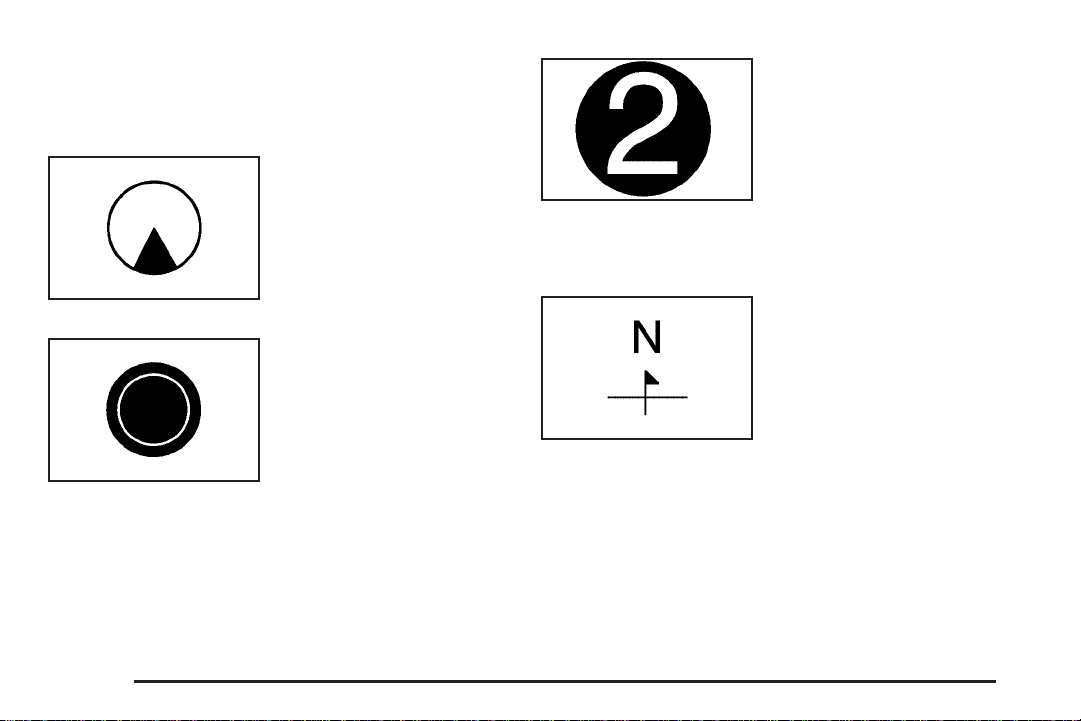
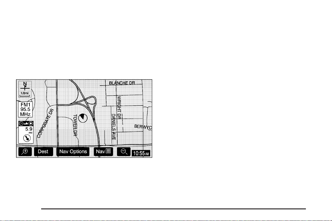
Symbols
The following symbols are the most common that
appear on a map screen.
Your vehicle is shown as
this symbol. It indicates the
current position and vehicle
orientation of your vehicle
on the map.
This red bulls-eye symbol
will appear on the map to
show your final destination
after a route has been
planned.
See Destination on page 2-17 for information on
planning a route.
When one of five possible
destinations have been set,
a circle with a number 1
through 5, depending on
which number destination it
is, will appear on the map
screen.
See “Preset Destinations” under Destination on
page 2-17 for more information.
This symbol indicates that
the map is shown with
North up (North Up mode).
While in North Up mode, North will always be at the
top of the map screen regardless of which direction the
vehicle is traveling. Touch this screen button to switch
between North Up and Heading Up modes. See “Map
Appearance” under Navigation Menu on page 2-7 for
more information.
2-6
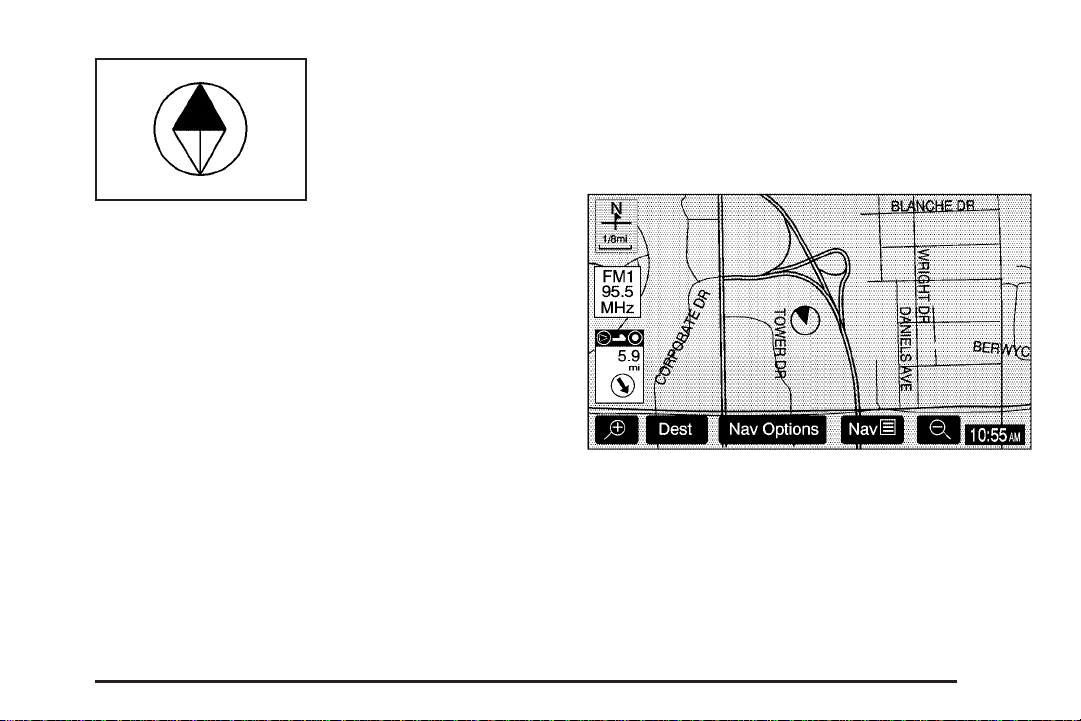
This symbol indicates that
the map is shown with the
vehicle travel direction
up (Heading Up mode).
The shaded triangle indicates North. While in Heading Up
mode, the direction your vehicle is traveling will always be
at the top of the map screen. Touch this screen button to
switch between Heading Up and North Up modes. See
“Map Appearance” under Navigation Menu on page 2-7
for more information.
Navigation Menu
Nav y (Navigation Menu): Touch the navigation
menu screen button at the bottom of the map screen to
access the main navigation menu.
The main navigation menu allows you to select from a
list of options and to use the available touch screen
buttons to make system adjustments and plan routes.
2-7
You will be able to select from the following items on
the main navigation menu:
Suspend Guidance
}
(Suspend Guidance): Select this screen button from
the Nav Menu to suspend guidance to all current and
programmed destinations, but the current route will be
retained in memory. You will no longer receive voice
prompts for navigation. The map can still be viewed by
pressing the NAV hard key. If you suspend guidance,
you can touch the Resume Guidance screen button to
resume the current route.
Route Overview
z
(Route Overview): Select the Route Overview
screen button to display the map with the route
highlighted. The total distance and estimated travel
time will also display.
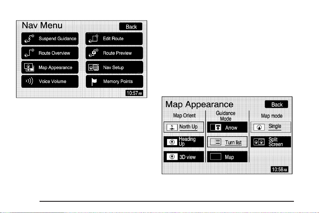
Map Appearance
v
(Map Appearance): Select the Map Appearance
screen button to adjust the appearance of a map based
on your preferences.
2-8

This menu is divided into three sections: Map
Orient (orientation), Guidance Mode, and Map Mode.
Touch an option’s screen button to select it. The following
are brief explanations of the options available in each
section:
y (North Up): This feature orients the map with
North at the top of the map screen, regardless of which
direction you are driving.
u (Heading Up): This feature orients the map with
the direction you are driving at the top of the map
screen, regardless of which direction is North.
u (3D view): This feature gives maps a
3-dimensional view, and will remain in the Heading Up
position.
s (Arrow): This feature continually displays
directional turn guidance for your next maneuver.
R (Turn list): This feature lists information on your
next three maneuvers, including the distance to the turn,
and street names.
? (Map): This feature will display your vehicle’s
current position, with the calculated route highlighted.
P (Single): This feature allows one map to be
displayed.
| (Split Screen): This feature allows two maps to be
displayed, which can be independently adjusted in both
scale and map orientation.
For more information on the symbols that can appear
on a map screen, see Symbols on page 2-6.
2-9

Voice Volume
!
(Voice Volume): Select the Voice Volume screen
button to adjust the volume of the voice guidance
prompts that provide various messages as you approach
points where you need to maneuver your vehicle, such as
an intersection.
To adjust the volume of the voice prompts, do the
following:
1. Touch the Voice Volume screen button.
2. Touch the plus (+) or minus (−) sign screen buttons
to increase or decrease the volume. The voice
prompt will come on with each adjustment to give
you an idea of the volume at each level.
3. Once you have reached the desired volume level,
touch the Back screen button to return to the
previous screen.
Adaptive Voice Volume Control: The volume of voice
prompts will increase automatically once the vehicle
exceeds 50 mph (80 km/h). Touch the On screen button
to activate this feature, or the Off screen button to turn
this feature off.
If voice guidance is not needed, lower the volume as far
as it will go, so the voice prompts are not heard.
2-10

Edit Route
t
(Edit Route): Select the Edit Route screen button
to recalculate a route based on your preferences.
Search Condition: This screen allows you to select
your route preference by choosing from Fastest,
Shortest, or Alternative route. By selecting the Fastest
route, you will be routed along main roads and highways,
which does not necessarily mean it will be the shortest
route.
Route Preference: This screen allows you to select
your road preferences by setting which types of roads
you want to use or avoid.
Destination: This feature allows you to add, reorder, or
delete destinations.
Set Preferred Road: This feature allows you to add,
modify, or delete road preference settings.
Route Overview: Touch this screen button to access
the Route Overview menu. See “Route Overview” under
Destination on page 2-17.
2-11

Route Preview
{
(Route Preview): Select the Route Preview screen
button once route guidance has begun to display the
map screen with the route highlighted.
The route is traced by the vehicle symbol as you travel.
You can preview the route from the starting position
to the final destination by touching the arrow screen
buttons inside the Route Preview pop-up menu.
Info (Information): Touch the Info screen button to
view POI information such as the POI name, address,
and phone number, if available.
Edit: Touch the Edit screen button to select a POI as
the next destination you would like to preview.
To preview a POI’s destination instead of the final
destination, do the following:
1. Touch the Edit screen button.
2. Touch the Select POI screen button.
3. Touch the screen button of the desired POI
category.
4. Touch the icon screen button of the desired POI,
then touch the OK screen button.
5. Touch the Back screen button twice to get to the
Edit Route Preview screen.
6. Touch the Next POI screen button, then touch the
OK screen button.
7. Touch the Back screen button to return to the
Route Preview screen.
Now when you touch the arrow screen buttons
to preview the route, it will trace the route to the
next selected POI rather than the route to the final
destination.
2-12

To return to previewing the route to the final destination,
do the following:
1. Touch the Edit screen button.
2. Touch the Next screen button.
3. Touch the OK screen button, then the Back screen
button to return to the Route Preview screen.
Now when you touch the arrow screen buttons to
preview the route, it will trace the route to the final
destination rather than the route to the next POI.
Use the following arrow screen buttons from the Route
Preview pop-up menu to trace a route:
Iq(Preview to current location): Touch this screen
button to preview the route traveling toward the vehicle’s
current location. Touch this screen button repeatedly to
increase the speed at which the indicator will trace
the route.
rh (Preview to final destination): Touch this
screen button to view the route traveling toward the
final destination. Touch this screen button repeatedly to
increase the speed at which the indicator will trace
the route.
It(View current location): Touch this screen
button to view the vehicle’s current location along the
current route.
uh (View final destination): Touch this screen
button to view the final destination along the
current route.
Navigation Setup
x
(Navigation Setup): Select the Nav Setup screen
button to display the Nav Setup menu.
From this menu, several options may be selected,
adjusted, or turned on and off. Touch the up or
down arrow screen buttons to the left of the
menu options to scroll through the list.
2-13

The following are the available options with a brief
explanation of each:
English/Metric: This feature switches distance
measurements between English or metric. Touch the
Miles screen button for English measurements, or the Km
(kilometers) screen button for metric measurements.
Notify Seasonal Restrict (Restrictions): This feature
notifies the driver of seasonal maneuver restrictions.
Touch the On screen button to have a voice prompt
warn of existing seasonal restrictions played at guidance
points. Touch the Off screen button to turn this
feature off.
Estimated Travel Time: This feature displays the
estimated time to travel from your current position to
the destination. Touch the On screen button to have
the estimated travel time displayed with the distance
to destination, or the Off screen button to turn this
feature off.
Enter Speed Change?: This feature allows you to
adjust estimated speeds for Freeway, Main street, or
Residential driving. These speed values are used to
calculate estimated travel time. To change estimated
speeds, touch the Yes screen button. The Change Speed
menu will appear. Touch the arrow screen buttons under
each road type to increase or decrease the speed. The
maximum allowable speed to set is 100 mph (161 km).
You may also touch the Default screen button to choose
factory default speed settings as your choice. When your
adjustments are complete, touch the Back screen button
to return to the Nav Setup menu.
Auto Reroute: With this feature on, the navigation
system will automatically recalculate a route if you drive
off course. Touch the Off screen button to turn this
feature off.
Voice Guide in All Mode: Touch the On screen button
to hear navigation voice prompts while in Audio mode.
Touch the Off screen button to turn this feature off.
Current Street Name: Touch the On screen button
to display the current street name that the vehicle
is traveling on. Touch the Off screen button to turn
this feature off.
Exit Information: This feature will display map icons
which can be selected to display the next exit’s
information, including Point of Interest (POI) facilities
such as gas stations, restaurants, and lodging. Touch
the On screen button to display exit information icons, or
touch the Off screen button to cancel the display of exit
information icons.
Map Color (Day): This feature allows you to
adjust the daytime map appearance. Choose
between Normal, Auto, 1, 2, 3, or 4. The numbered
settings vary the color scheme of the map display.
2-14

The Auto setting will change the map appearance
automatically every three months. When the desired color
setting has been selected, press the NAV hard key to
view the adjusted map color.
Map Color (Night): This feature allows you to adjust the
nighttime map appearance. Choose between Normal,
Auto, 1, 2, 3, or 4. The numbered settings vary the color
scheme of the map display. The Auto setting will change
the map appearance automatically every three months.
When the desired color setting has been selected, press
the NAV hard key to view the adjusted map color.
Calibrate System?: This feature will calibrate wheel
speed to assist in the calculation of vehicle position.
This feature also allows you to manually reposition the
vehicle symbol on the map. You may need to calibrate
the system following a tire change, rotation, or if your
vehicle has been relocated a great distance. Touch the
Yes screen button to calibrate the system, or the No
screen button to leave the calibration as it is. See Vehicle
Positioning on page 2-34 for more information.
Select Defaults?: This feature allows you to restore
all available factory default settings in the Nav Setup
menu. Touch the Yes screen button to restore defaults,
or the No screen button to retain the current settings.
Memory Points
w
(Memory Points): Select the Memory Points screen
button to display the Memory Points menu. This menu
contains options for registering, deleting, and editing
marked points stored in memory, such as memory points,
preset destinations, and areas to avoid.
Memory Points: Choosing to add a memory point will
take you to the Destination menu. You may register up to
30 memory points. The name, location, information, and
icon for a memory point may also be edited.
2-15

Preset Dest (Destination): Five preset destinations, as
well as one for home, may be registered or edited. The
five preset destinations, home, and Emergency are the
only destination selections available from the Destination
menu while the vehicle is moving. These presets are
shown as the home symbol and numbered presets
1 through 5 at the bottom of the Destination menu.
See Destination on page 2-17 for more information on
how to register Memory Points and preset destinations.
Areas to Avoid: Up to 10 areas to avoid may also be
registered from the Memory Points menu. Areas to avoid
include areas such as high traffic areas, construction
areas, or any main roads, or intersections you want to
avoid. When registering or editing an area to avoid, the
size of the area may also be increased or decreased by
touching the up or down arrow screen buttons on the
scroll bar.
Register Home: Touch this screen button to access the
Register Home screen. Choose a method of destination
entry and enter the destination you would like to store as
home. Once your entry is complete, touch the Register
Point screen button to store this point as home. Each
time you touch the home symbol from the bottom of the
Destination screen, this destination will be calculated.
Once you have stored a destination as home, the
Register Home screen button will change to read Delete
Home. You may then touch this screen button to delete
the destination you have stored as home.
Del. Prev. Dest. (Delete Previous Destination): Touch
this screen button to delete a previous destination. A list
of previous destinations will display on the Delete
Previous Dest screen. Touch the screen button next to
the previous destination you wish to delete. You will be
asked to confirm your decision. Touch the Yes screen
button to delete the destination or touch the No screen
button to cancel the deletion.
You may also touch the Del. All screen button from
the Delete Previous Dest screen to delete all previous
destinations listed. You will be asked to confirm this
decision as well. Touch the Yes screen button to delete
all previous destinations or touch the No screen button to
cancel the deletion.
2-16

Destination
The Destination menu gives several ways to plan a
route by entering destination points.
Touch the Dest screen button at the bottom of the map
screen to display the Destination menu.
Search Area: The Destination menu allows you to
select the area to be searched for your destination.
A map of the 48 contiguous United States, including
Hawaii, and Canada will be shown. The map is divided
into nine regions.
Before selecting a destination, review the search area
map on the right side of the menu to make sure
your destination is located in the highlighted region.
2-17

Change: Touch this screen button, on the Destination
menu, to see a more detailed search area map with
a list of states, or to change the search area. The
Search Area screen will appear. Touch the numbered
screen button to the left of the map that corresponds
with the numbered region you wish to choose.
Delete Dest (Destination): Touch the Delete Dest
screen button on the Destination menu to delete
the current destination.
k / l (Up and Down Arrows): Touch the up or down
arrow screen buttons, on the Destination menu, to scroll
through the pages of the menu.
Once your destination entry is complete, a screen
with the destination preview menu will display. See
“Destination Preview Menu” later in this section for
more information.
To enter a destination, choose from one of the following
destination entry methods:
Preset Destinations
The preset destination entry method allows you to
select destinations that were registered as presets
1 through 5.
These presets, along with the home symbol preset, are
located at the bottom of each page of the Destination
menu. Besides the home preset destination and
Emergency destination entry method, these are the only
presets available for selection while the vehicle is moving.
2-18

Address
The Address destination entry method allows you to
input an address by providing the system with a house
number, street name, and city name.
If you know the city where the address is located, touch
the City screen button. The City screen allows you to
select from the last five cities entered, the nearest five
cities to the current location, or you may enter in the
name of the city. Touch the Input City Name screen
button and enter in the city using the alpha keypad.
See “Alpha-Numeric Keypad” under Using the Navigation
System on page 2-2 for more information.
Use the same city name that you would use when mailing
a letter. The system will search for an entry exactly as
you have entered it. If you did not include a space
between words where necessary, the system may not
be able to find the desired location. As information is
entered, the system will automatically search for available
names, and the List screen button will become available.
Touch the List screen button to view name choices and
select the desired city name, or touch the Back screen
button to continue to spell the city name, further reducing
the number of available items. The box at the end of the
Street entry field will contain the number of city names
available in the current generated list. If you do not
know the city, proceed to entering the street name.
Enter the street name using the alpha keypad. See
“Alpha-Numeric Keypad” under Using the Navigation
System on page 2-2 for more information. Do not include
name extensions such as N. or Drive. For example,
the street name N. Civic Center Drive should be entered
as Civic
entry exactly as you have entered it. If you did not
include a space between words where necessary,
the system may not be able to find the desired
location. As information is entered, the system
will automatically search for available names,
and the List screen button will become available.
UCenter. The system will search for an
2-19

Touch the List screen button to view name choices and
select the desired street name, or touch the Back
screen button to continue to spell the street name,
further reducing the number of available items. The
box at the end of the Street entry field will contain the
number of street names available in the current
generated list.
Once the street name has been selected, enter the house
number using the numeric keypad. The system will list
the house number range that is available for the street.
When you have finished entering the house number,
touch the OK screen button. If the address number exists
on more than one street that shares the same name, a list
of matching street names will display. Touch the screen
button by the desired street name.
If you have not already entered in the city name for the
address, a list of cities that contain the address will
display. Touch the screen button by the desired city
to select it.
Point of Interest (POI)
The Point of Interest (POI) destination entry method
allows you to choose a destination from the POI list.
Select the POI screen button from the Destination menu
to access the POI entry menu. The POIs in the database
are cross referenced between Name, Category, and City.
Search for a POI by using a combination of the following
three methods:
• Type in a POI by name using the alpha-numeric
keypad. As you type in a name, the system will
search for an available match. Select the
desired POI.
2-20

While inputting a POI or city name, the List screen
button will become available. The box at the end of
the Name entry field will contain the number of items
in the current generated list. Touch the List screen
button to view the list of available names, or continue
to spell the name to further reduce the list.
• Select a POI by selecting the Category option. Select
a category from the list. If the list of available POIs for
the category selected is still too long, you may need
to input the name or city for the POI.
• Touch the City screen button and type in the city you
wish to select a POI from.
If an arrow appears to the right or left of the item name,
the complete name is too long for the display. Touch
the right or left arrow screen buttons to scroll to the end
or beginning of the name.
The POI for Restaurant is broken down into several
categories. Select the Restaurant screen button from
the POI choices. A list of cuisine types will then appear.
Memory Points
The Memory Points destination entry method allows
you to select a destination by choosing from a list
of marked points on the map that were previously
marked.
Memory points include up to 30 saved points, five preset
destinations, and a home destination. Select the Memory
Points screen button from the Destination screen to
select any one of the marked points as the active
destination. Marked points can also be sorted by
icon, date saved, or alphabetically.
If a memory point has been registered, you can select an
icon to correspond with that memory point. To register
that memory point with a sound, touch the With Sound
screen button, then select a sound.
See “Memory Points” under Navigation Menu on
page 2-7 for more information.
2-21

Previous Destination
The Previous Destination entry method allows you to
select a destination by selecting from a list of previously
entered destinations.
Emergency
The Emergency destination entry method allows you to
select a destination by selecting from a list of emergency
facilities. The list will vary by area.
Touch the number next to the destination to select it.
2-22
Selecting Police Station or Hospital will display a list.
The list can be changed to appear in alphabetical order
or in order by distance from your vehicle’s location.
The Emergency destination entry method can be
selected while the vehicle is moving.

Map
The Map destination entry method displays the last
location on the map, and the road preference.
Scroll across and touch the map at the location you would
like to set as your destination. Once you have located the
desired destination, touch the Enter Destination screen
button and then the OK screen button. The route will then
be calculated. Begin driving to start route guidance or
touch the Route screen button and then the Start screen
button.
You can zoom out to view the entire regional map. See
“Touch-Sensitive Screen Buttons” under Using the
Navigation System on page 2-2 for more information.
However, if you zoom out as much as possible and scroll
around the map, some parts of the map will appear to be
missing because they are not readable in larger scales.
Previous Start Point
The Previous start point destination entry method allows
you to select the last start point as a destination.
Phone Number
The Phone Number destination entry method allows you
to search for a point of interest (POI) destination by
entering the POI phone number.
Enter the POI phone number on the numeric keypad and
touch the OK screen button. The destination location will
display. Most phone numbers for POIs included in the
DVD database can be entered to locate a destination.
Cellular phone numbers and internal company phone
numbers cannot be entered to locate a destination.
2-23

Intersection
The Intersection destination entry method allows you to
select a destination by inputting the intersecting roads.
To enter a destination using this method, enter the name
of the street, but do not include name extensions such as
N. or Drive. For example, the street name N. Civic Center
Drive should be entered as Civic
system will search for an entry exactly as you have
entered it. If you did not include a space between words
where necessary, the system may not be able to find the
desired location. This will bring up a list of streets with
that name. Select the desired street name from the list.
Now begin entering the second street name, and select
the desired street name from the list. After both street
names in the intersection have been selected, a list of
cities containing the selected intersection will appear.
If there are several cities that contain that specific
intersection, you must specify a city. Select the desired
city from the list. The route will then be calculated. Begin
driving to start route guidance or touch the Route screen
button and then the Start screen button.
UCenter. The
2-24

Freeway Entrance/Exit
The Freeway Entrance/Exit destination entry method
allows you to select a destination by entering a freeway
entrance or exit point.
Enter Freeway names using the alpha keypad. See
“Alpha-Numeric Keypad” under Using the Navigation
System on page 2-2 for more information. After entering
the freeway name, enter the name of the entrance or
exit that you want to set as the destination.
Destination Preview Menu
Each time a destination is entered, a screen with the
destination preview menu will appear. This screen
will display a zoomed in view of the destination, as
well as the following options:
Enter Destination: Touch this screen button to set the
current destination as the only destination in the system.
The route will be calculated and the Route Preview
screen will display.
Add Waypoint: Touch this screen button to add the
current destination to your current trip. The Add Waypoint
screen will display. Touch the Add screen button that
corresponds with where you would like to add the current
destination.
2-25

Info (Information): When a POI icon is selected on the
screen, touch this screen button to display the name,
address, and telephone number, if available, for the
selected POI. See “Navigation Options” later in this
section for more information on POIs and their icons.
Route Preference: This option will display the Route
Preference screen. To adjust route preferences,
touch Change. See “Edit Route” under Navigation
Menu on page 2-7 for more information.
Once the desired adjustments from the destination
preview menu are complete, the route overview menu
can be displayed. See “Route Overview Menu” following
in this section for more information.
Once you have entered your destination by touching
the Enter Destination screen button, you can do one of
the following:
• Press the NAV hard key to begin route guidance.
• Start driving to begin route guidance.
• Touch the Route screen button on the map screen
displaying the new destination to make further
changes. See “Route Overview” following in this
section for more information.
Route Overview Menu
Each time a destination has been selected and entered,
the route overview menu can be displayed by touching
the Route screen button on the map screen.
The following three options will display:
Start: Touch this screen button to select the current
highlighted route and begin route guidance.
3 Routes: Touch this screen button to display the map
with three highlighted routes shown in three different
colors indicating the Fastest, Shortest, and Alternative
routes.
2-26

After selecting one of the three routes, the road distance
and estimated travel time will display. The Fastest
route means you will be routed along main roads and
highways, but does not necessarily mean it is the shortest
route. Touch the Time & Distance screen button to view
the road distance and estimated travel time for each of
the three routes.
Edit Route: Touch this screen button to change the
route preferences. See “Edit Route” under Navigation
Menu on page 2-7 for more information.
Press Back at any time to return to the previous screen.
Navigation Options
Nav Options Menu shown with a Set Destination
Once a destination is selected and you begin your
route, touch the Nav Options screen button to view a
menu with additional route options. Select from the
following route options:
POI Icon Off: This option allows you to turn off Point of
Interest (POI) icons shown on the map.
POI Selection: This option allows you to select which
types of POIs will be displayed on the map.
2-27

After selecting POI selection, the POI Selection screen
will appear and display the different POI categories.
You can select up to five different POI categories
by touching the categories on the screen. Touch the
More screen button to view more categories. The icons
for the selected categories will appear at the top of
the screen and will display on the map.
2-28
To view a list of local POIs, touch the Local POI List
screen button. The Local POI List screen will list the
closest POIs from the categories you have selected. You
can sort these POIs by distance, icon/category, or name.
Touch the Route screen button to display POIs along
your current route. Once you select the desired POI, a
map of the area with a symbol marking the destination
will display.
Suspend Guidance: This option allows you to suspend
active route guidance for all current and programmed
destinations. See “Suspend Guidance” under Navigation
Menu on page 2-7 for more information.

Cancel Route: This option allows you to cancel the
current or first destination. The second programmed
destination will then be used if one is available.
Change Route: This option allows you to change the
route search condition while the vehicle is moving.
The following options may be available:
• Detour for 1 mile?: Touch the Yes screen button to
recalculate your route and detour one mile around
the vehicle’s current position.
• Detour for 3 miles?: Touch the Yes screen button to
recalculate your route and detour three miles around
the vehicle’s current position.
• Change to fastest?: Touch the Yes screen button to
recalculate to the fastest route.
• Change to shortest?: Touch the Yes screen button to
recalculate to the shortest route.
• Reroute from adjacent road?: Touch the Yes screen
button to recalculate from another road on your
route, near the vehicle’s current position.
Register Point: This option allows you to register a
marked point or memory point. See “Memory Points”
under Navigation Menu on page 2-7 for more
information.
Right Screen: If a split-screen is currently displayed,
this option allows you to adjust options for the right
screen.
If the position on the map is away from the current
vehicle position, touch the Nav Options screen button,
to select from the following four options:
POI Icon Off: This option allows you to turn off Point of
Interest (POI) icons shown on the map.
Enter Destination: This option allows you to set a
location you have chosen on the map as your destination.
See “Map” earlier in this section for more information on
this destination entry method.
Add Waypoint: This option allows you to add the map
destination to your current destinations.
Register Point: This option allows you register a
marked point or memory point. See “Memory Points”
under Navigation Menu on page 2-7 for more information.
2-29

Colors on the Screen
When a route has been planned, it will be highlighted
on the screen in blue.
Different colors are also used to distinguish between
interstate freeways, state highways, county roads, major
streets, and secondary streets. Highways will be shown
as a thicker line than a general street.
Configure Menu
The Configure menu allows you to set up and adjust such
things as screen color, appearance, and language of the
display for the navigation system. Press the CONFIG
hard key to access the Configure menu. See Navigation
System Overview on page 1-2 for more information.
Contrast/Brightness
To adjust the contrast or brightness of the navigation
screen, touch the plus (+) or minus (–) sign screen
buttons to increase or decrease the contrast or
brightness to the desired level. You will see the screen
change as you adjust the contrast or brightness.
2-30

Screen Color
When the exterior lamps are on during the day, the
navigation screen will change to a lighter background
and change colors for better viewing in the daylight.
At night, the screens background will become darker.
Touch the Auto screen button for automatic adjustment.
Touch the Day or Night screen buttons to select day
or night mode regardless of the lighting conditions. The
Day setting leaves the system in the day mode. The
Night setting leaves the system in the night mode.
Beep
With this feature on, a beep will sound every time a
screen button is pressed on the navigation screen.
Select Off to turn the beeps off.
Vehicle Chime
Notice: The chime signals related to seat belts,
parking brake, and other functions of your vehicle
operate through the navigation/radio system. If that
equipment is replaced or additional equipment is
added to your vehicle, the chimes may not work.
Make sure that replacement or additional equipment
is compatible with your vehicle before installing it.
This feature allows you to adjust the chime volume level
in your vehicle. Touch the Normal screen button for
normal chime volume or the Loud screen button for a
louder chime volume.
Language
Your vehicle has been set for the English language, but
you may also select French for all instructional text and
voice prompts. However, names on the map when using
the navigation functions will not change.
To change the language, the map DVD must be
inserted. Then, do the following:
1. Touch the Language screen button. A caution will
display.
2. Touch the desired language to select it.
3. Touch the NEXT screen button to change the
display back to the map screen.
If the language is changed from English, the menu
screens will not match word-for-word as they appear
in this manual.
If you accidentally select a language you do not
understand, press the CONFIG hard key, then select
the desired language.
2-31

Clock
To adjust the time displayed at the lower right corner
of the navigation screen, as well as other time options,
touch the Clock screen button. This will take you to the
Adjust Clock screen.
You may also touch the time display in the lower right
corner of the navigation screen to briefly display the date.
To change the hours and minutes on the clock, do the
following:
1. Touch the Manual Adjust screen button.
2. Touch the up or down arrow screen buttons to
increase or decrease the hours and minutes.
3. Touch the Back screen button to return to the
previous screen.
12Hr/24Hr: This feature allows you to choose whether
the time is displayed in standard or military time. Touch
the 12Hr screen button for standard time or the 24Hr
screen button for military time.
Auto GPS Update: With this feature on, the navigation
system time will be set to match the current GPS time.
The time will be updated with the GPS time when the
ignition is turned on. Touch the Off screen button to turn
this feature off.
Daylight Savings: With this feature on, the navigation
system will automatically adjust the time for Daylight
Savings. Touch the Off screen button to turn this
feature off.
Time Zone: This feature allows you to select from
five different time zones: HST (Hawaii), PST (Pacific),
MST (Mountain), CST (Central), and EST (Eastern).
Touch the desired time zone screen button to select it.
2-32

Display Off
To turn the navigation screen off, touch the Disp Off
screen button on the Configure menu. To turn the
screen back on, press any hard key to the left of
the navigation screen.
Global Positioning System (GPS)
The Navigation System determines the position of your
vehicle by using satellite signals, various vehicle signals
and map data.
At times, other interferences such as the satellite
condition, road configuration, the condition of the
vehicle and/or other circumstances can interfere with
the Navigation’s ability to determine the accurate position
of the vehicle.
The GPS shows the accurate current position of your
vehicle using signals sent by the GPS Satellites of the
United States Department of Defense. When your vehicle
is not receiving signals from the satellites, a symbol will
appear on the map screen.
This system may not be available/or interference may
occur if the following happens:
• Signal obstructions caused by tall buildings, large
trucks, tunnels,
• objects located on top of the instrument panel,
• satellites will not send signals if they are being
repaired or improved,
• after-market glass tinting has been applied to the
vehicle’s windows.
Notice: Do not apply after-market glass tinting to
the vehicle’s windows. Glass tinting will interfere
with the system’s ability to receive GPS signals and
cause the system to malfunction. You might have
to replace the window to correct the problem.
This would not be covered by your warranty.
For more information if you are experiencing a problem,
see If the System Needs Service on page 2-35 and
Problems with Route Guidance on page 2-35.
2-33

Vehicle Positioning
At times, the position of the vehicle on the map may be
inaccurate due to one or more of the following reasons:
• The road system has changed.
• The vehicle is driving on slippery road surfaces such
as in sand, gravel, and/or snow.
• The vehicle is traveling on winding roads.
• The vehicle is on a long straight road.
• The vehicle is approaching a tall building or a
large vehicle.
• The surface streets run parallel to a freeway.
• The vehicle has just been transferred by a vehicle
carrier or a ferry.
• The current position calibration is set incorrectly.
• The vehicle is traveling at high speed.
• The vehicle changes directions more than once,
or when the vehicle is turning on a turn table in a
parking lot.
• The vehicle is entering and/or exiting a parking lot,
garage, or a lot with a roof.
• The GPS signal is not received.
• A roof carrier is installed on your vehicle.
• The vehicle is being driven with tire chains.
• The tires are replaced.
• The tire pressure for your tires is incorrect.
• The tires are worn.
• The first time the map DVD is inserted.
• The battery is disconnected for several days.
• The vehicle is driving in heavy traffic where driving is
at low speeds, and the vehicle is stopped and started
repeatedly.
If you experience problems with your system,
see your dealer.
2-34

Problems with Route Guidance
Inappropriate route guidance may occur under one or
more of the following conditions:
• You have not turned onto the road indicated.
• Route guidance may not be available when using
automatic rerouting for the next right or left turn.
• The route may not be changed when using
automatic rerouting.
• There is no route guidance when turning at an
intersection.
• Plural names of places may be announced
occasionally.
• It may take a long time to operate automatic
rerouting during high-speed driving.
• Automatic rerouting may display a route returning to
the set waypoint if you are heading for a destination
without passing through a set waypoint.
• The route prohibits the entry of a vehicle due to a
regulation by time or season or any other regulation
which may be given.
• Some routes may not be searched.
• The route to the destination may not be shown if
there are new roads, if roads have recently changed,
or if certain roads are not listed on the map DVD.
See Ordering Map DVDs on page 2-35.
To recalibrate the vehicle’s position on the map, see
your dealer.
If the System Needs Service
If your system needs service and you have followed the
steps listed here and still are experiencing problems,
see your dealer for assistance.
Ordering Map DVDs
The map DVD in your vehicle is the most up-to-date
information available when your vehicle was purchased.
The map DVD is updated periodically, provided that
the map information has changed. To order a new map
DVD, contact your dealer.
Database Coverage Explanations
Coverage areas vary with respect to the level of map
detail available for any given area. Some areas will
feature greater levels of detail than others. If this
happens, it does not mean there is a problem with the
system. As the map DVD is updated, more detail may
become available for areas which previously had limited
detail. See Ordering Map DVDs on page 2-35.
2-35

✍ NOTES
2-36

Section 3 Navigation Audio System
Navigation Audio System ..................................3-2
Rear Seat Entertainment System ....................3-12
3-1

Navigation Audio System
Notice: Before adding any sound equipment to your
vehicle, such as an audio system, CD player, CB
radio, mobile telephone, or two-way radio, make sure
that it can be added by checking with your dealer.
Also, check federal rules covering mobile radio and
telephone units. If sound equipment can be added,
it is very important to do it properly. Added sound
equipment may interfere with the operation of your
vehicle’s engine, radio, or other systems, and even
damage them. Your vehicle’s systems may interfere
with the operation of sound equipment that has been
added.
Notice: The chime signals related to seat belts,
parking brake, and other functions of your vehicle
operate through the navigation system. If that
equipment is replaced or additional equipment is
added to your vehicle, the chimes may not work.
Make sure that replacement or additional equipment
is compatible with your vehicle before installing it.
See “Accessories and Modifications” in the Index
of your vehicle’s owner manual.
Your vehicle has a feature call Retained Accessory
Power (RAP). With RAP, the audio system will continue
to play even after the ignition is turned off. See “Retained
Accessory Power (RAP)” in the Index of your vehicle’s
owner manual for more information.
The audio system is operated using navigation
system menus.
Playing the Radio
O
(Power/Volume): Press this knob to turn the audio
and navigation system on and off. Turn the knob to
increase or decrease the volume.
Finding a Station
BAND: Press this hard key to access the band menu
and to switch between AM, FM1, FM2, XM1, or XM2, if
equipped.
O (Tuning) Knob: Turn this knob to change radio
frequencies.
w SEEK x: Press the SEEK up or down arrows to
go to the next or previous station and stay there.
To scan stations, press and hold the SEEK up or down
arrow for two seconds until you hear a beep. The radio
will go to a station, play for a few seconds, then go on to
the next station. Press either SEEK arrow again to stop
scanning.
3-2

To scan preset stations, press and hold the SEEK up or
down arrow for more than four seconds. You will hear
two beeps and PSCAN will appear on the display, along
with the highlighted preset. The radio will go to one of
the preset stations, play for a few seconds, then go on to
the next preset station. Press either SEEK arrow
again to stop scanning presets.
The radio will only seek and scan stations with a strong
signal that are in the selected band.
Setting Preset Stations
Up to 30 stations, six AM, six FM1, six FM2, six XM1,
and six XM2, if equipped, can be programmed using the
six touch screen buttons on the bottom of each band
menu. To set preset stations, do the following:
1. Turn the audio system on.
2. Press the BAND hard key to select AM, FM1, FM2,
XM1, or XM2, if equipped.
3. Tune to the desired station using the SEEK hard
key arrows or the tuning knob.
4. Press and hold one of the six preset screen buttons
until you hear a beep. Whenever that preset screen
button is pressed, the station that was set will return.
5. Repeat the steps for each preset and source.
Band Menu
If the radio is on while the navigation system is not in use,
this band menu will display the current audio information,
as well as list the presets for the current band.
FM1 Source shown, Other Sources similar
3-3

If the radio is on while the navigation system is in use, a
smaller band menu will appear, located on the left side of
the map screen. This audio screen will display the current
audio information, such as band and station. Touch the
smaller band menu screen button to access the
band menu.
Audio Menu
e
(Audio): Press this hard key to display the Audio
menu. Several adjustment options are available from
this menu.
FM1 Source shown, Other sources Similar
3-4
Audio Menu
Tone (Bass/Midrange/Treble): Touch the plus (+) and
minus (–) sign screen buttons to increase or decrease
the Bass, Midrange, or Treble. If a station is weak
or noisy, decrease the treble.

Speakers (Balance/Fade): Touch the L (left) or R (right)
screen buttons to adjust the balance between the right
and left speakers. Touch the Front or Rear screen
buttons to adjust the fade between the front and rear
speakers.
Speed Compensated Volume (SCV): With SCV, the
audio system will adjust automatically to make up for road
and wind noise as you drive, by increasing the volume as
vehicle speed increases. Touch the down arrow button
to access the second page of the Audio menu. Set the
volume at the desired level, then select Low, Med, or
High. The volume level should always sound the same
to you as you drive. To turn SCV off, touch the Off screen
button.
EQ (Equalizer): Use the screen buttons labeled EQ1
through EQ5 to choose preset bass, midrange, and
treble equalization settings. The Custom screen button
allows you to choose and set the equalization levels.
To set a custom equalization setting, adjust each setting
to the desired level, then touch the Custom screen
button until you hear a beep.
After adjustments are made, press the BAND hard key to
go back to the preset station menu. Now that you have
preset the station and the EQ setting, you can assign the
EQ to the preset station. To do this, touch the desired
preset station screen button until you hear a beep. The
EQ setting will now be assigned to that station unless you
decide to change it.
If you were at the CD screen before setting an EQ and
you press the CD hard key, you will be returned to the CD
screen, and the EQ will be set to that screen until you
change it.
See “Rear Seat Audio (RSA)”, “Theft-Deterrent Feature”,
“Audio Steering Wheel Controls”, “Radio Reception”,
and the antenna information in the Index of your
vehicle’s owner manual for more information.
3-5

Radio Data Systems (RDS)
The audio system has a Radio Data System (RDS). RDS
features are available for use only on FM stations that
broadcast RDS info. With RDS, the radio can do the
following:
• Display station name
• Display messages from radio stations
• Display song title and artist name
This system relies on receiving specific information from
these stations and will only work when the information is
available. In rare cases, a radio station may broadcast
incorrect information that will cause the radio features to
work improperly. If this happens, contact the radio station.
While the radio is tuned to an RDS station, the station
name will appear on the display with the frequency.
Touch the Info screen button on the band menu
to receive information the selected radio station is
currently broadcasting.
XM™ Satellite Radio Service
XM™ is a satellite radio service that is based in the
48 contiguous United States. XM™ offers over
100 coast-to-coast channels including music, news,
sports, talk, and children’s programming. XM™ provides
digital quality audio and text information, including song
title and artist name. A service fee is required in order to
receive the XM™ service. For more information,
contact XM™ at www.xmradio.com or call
1-800-852-XMXM (9696).
Press the BAND hard key repeatedly until you reach
the XM™ selection. When XM™ is active, the channel
name and number, song title and artist will display
on the screen.
Touch the XM Info screen button to display additional
XM station information.
3-6

XM™ Options
Touch the XM Options screen button to access the
XM Options menu.
This menu allows you to seek or scan for stations
based on their category. Touch the On screen button
next to XM Info Timeout to hide XM™ information after
a certain amount of time has passed. Touch Off to
turn this feature off.
While in this menu, turn XM Category Seek/Scan on to
scroll through the categories you want to seek to. This
option will take you to the first available channel in that
category.
3-7

XM™ Radio Messages
Radio Display
Message
XL (Explicit Language
Channels)
XM Updating Updating
No XM signal Loss of signal The system is functioning correctly, but the vehicle is in a
Loading XM Acquiring channel audio
Channel Off Air Channel not in service This channel is not currently in service. Tune in to another
Channel Unavail Channel no
No Artist Info Artist Name/Feature
No Title Info Song/Program
Condition Action Required
XL on the radio display,
after the channel name,
indicates content with
explicit language.
encryption code
(after 4 second delay)
longer available
not available
Title not available
These channels, or any others, can be blocked at a
customer’s request, by calling 1-800-852-XMXM (9696).
The encryption code in the receiver is being updated, and
no action is required. This process should take no longer
than 30 seconds.
location that is blocking the XM™ signal. When you move
into an open area, the signal should return.
The audio system is acquiring and processing audio and
text data. No action is needed. This message should
disappear shortly.
channel.
This previously assigned channel is no longer assigned.
Tune to another station. If this station was one of your
presets, choose another station for that preset button.
No artist information is available at this time on this
channel. The system is working properly.
No song title information is available at this time on this
channel. The system is working properly.
3-8

XM™ Radio Messages (cont’d)
Radio Display
Message
No CAT Info Category Name not
Not Found No channel available for
No Information No Text/Informational
XM Theftlocked Theft lock active The XM™ receiver in your vehicle may have previously
XM Radio ID Radio ID label
Unknown Radio ID not known
Check XM Receiver Hardware failure If this message does not clear within a short period of time,
See “Radio Reception” and “XM™ Satellite Radio Antenna System” in the Index of your vehicle’s owner manual for
more information.
Condition Action Required
available
the chosen category
message available
(channel 0)
(should only be if
hardware failure)
No category information is available at this time on this
channel. The system is working properly.
There are no channels available for the selected category.
The system is working properly.
No text or informational messages are available at this
time on this channel. The system is working properly.
been in another vehicle. For security purposes, XM™
receivers cannot be swapped between vehicles. If this
message is received after having your vehicle serviced,
check with your GM dealer.
If tuned to channel 0, this message will alternate with the
XM™ Radio eight digit radio ID label. This label is needed
to activate the service.
If this message is received when tuned to channel 0, there
may be a receiver fault. Consult with your GM dealer.
your receiver may have a fault. Consult with your GM dealer.
3-9

Playing a CD
Remove the navigation map DVD from the slot and
return it to its case. Insert a CD partway into the slot,
label side up. The player will pull it in.
There will be a 12 to 15 second delay while the CD is
read, before it begins to play. When the player begins to
read a CD, the Disc Check in Process message will
appear briefly to remind you of the delay. When the map
DVD is reinserted and read, the DVD Check in Process
message will appear briefly to remind you of the delay.
If the ignition or radio is turned off with a CD in the player,
it will stay in the player. When the ignition or radio is
turned on, the CD will start playing where it stopped,
if it was the last selected audio source.
If playing a CD-R the sound quality may be reduced due
to CD-R quality, the method of recording, the quality of
the music that has been recorded, and the way the CD-R
has been handled. There may be an increase in skipping,
difficulty in finding tracks, and/or difficulty in loading and
ejecting. If these problems occur, check the bottom
surface of the CD. If the surface of the CD is damaged,
such as cracked, broken, or scratched, the CD will not
play properly. If the surface of the CD is soiled, see “Care
of Your CDs” in the Index of your vehicle’s owner manual.
If there is no apparent damage, try a known
good CD.
Notice: If you add any label to a CD, insert more
than one CD into the slot at a time, or attempt to play
scratched or damaged CDs, you could damage the
CD player. When using the CD player, use only CDs
in good condition without any label, load one CD at a
time, and keep the CD player and the loading slot free
of foreign materials, liquids, and debris.
Do not add any label to a CD, it could get caught in the
CD player. If a CD is recorded on a personal computer
and a description label is needed, try labeling the top
of the recorded CD with a soft marker instead.
If an error appears on the display, see “CD Messages”
later in this section.
While playing a CD in the CD player, the navigation
system is not available. A message will display if the
NAV key is pressed. If your vehicle is equipped with
Rear Seat Entertainment (RSE), you can play an audio
CD while using the navigation system. See Rear Seat
Entertainment System on page 3-12 for more information.
3-10

B (CD): Press this hard key to play a CD when
listening to the radio. The CD screen will be displayed.
Y (Eject): Press this hard key to eject a CD.
Random: Touch this screen button to play the tracks in
random, rather than sequential, order. Touch it again to
turn off random play.
Repeat: Touch this screen button to repeat the track
that is currently playing. Touch it again to turn off
repeat play.
[ (Forward): Touch this screen button to advance
quickly within a track. As the CD advances, elapsed time
will display to help you find the correct passage. Release
this screen button to play the passage.
r (Reverse): Touch this screen button to reverse
quickly within a track. As the CD reverses, elapsed time
will display to help you find the correct passage. Release
this screen button to play the passage.
u (Track Forward): Touch this screen button to
advance to the next track on the CD.
t (Track Reverse): Touch this screen button to
return to the previous track on the CD.
w SEEK x: Press and release the SEEK up arrow to
advance to the next track, or the down arrow to return
to the previous track. If more than two seconds of
the song has played, pressing the SEEK down arrow
will return you to the beginning of the current track.
Track Scan: Press and hold one of the SEEK arrows
for two seconds or more to enter CD TRACK SCAN
mode. A chime will sound. The first 10 seconds of each
track will play. Press one of the SEEK arrows again
to stop scanning.
BAND: Press the BAND hard key to listen to the radio
when a CD is playing.
3-11

CD Messages
CD ERROR: If this message appears on the screen,
the CD is not being read by the system. The CD could
be dirty, scratched, wet, or upside down. You may
also be driving on a very rough road. When the road
becomes smoother, the CD should play.
NO MUSIC DISC: If this message appears on the
screen, the map DVD is still inserted in the system.
Press eject and return the map DVD to its case, then
insert a CD. The CD should play.
NO DISC: If this message appears on the screen, the
CD slot is empty. Insert a CD. The CD should play.
If a CD is not playing correctly for any other reason, try
a known good CD. If any error occurs repeatedly or
if an error cannot be corrected, contact your GM dealer.
If your radio displays an error message, write it down
and provide it to your GM dealer when reporting
the problem.
See “Rear Seat Audio (RSA)”, “Care of Your CDs and
DVDs”, “Care of Your CD and DVD Player” in the Index
of your vehicle’s owner manual for more information.
Rear Seat Entertainment System
Your vehicle may have a DVD Rear Seat Entertainment
(RSE) system. While playing a DVD or audio CD in the
RSE, press the CD key to view the RSE screen and to
switch to DVD as your main audio source. At this point,
you will hear what is being played in the RSE system
through all of the vehicle’s speakers. From the RSE
screen you can mute the Front or Rear speakers, mute
RSE entirely, or turn off RSE.
When the RSE system is turned off, you must turn it
back on from the RSE system. It cannot be turned back
on through the navigation system radio.
3-12

RSE Messages
CD ERROR: If this message appears on the navigation
screen, the DVD or CD is not being read by the system.
The DVD or CD could be dirty, scratched, wet, or upside
down. You may also be driving on a very rough road.
When the road becomes smoother, the DVD or CD
should play.
RSE ERROR: If this message appears on the
navigation screen, the RSE system is not working
properly. See “DVD Messages” under “Rear Seat
Entertainment System” in the Index of your vehicle’s
owner manual for more information.
NO DISC: If this message appears on the navigation
screen, the DVD slot is empty. Insert a DVD or CD. The
DVD or CD should play.
See “Rear Seat Entertainment System”, “Rear Seat
Audio (RSA)”, “DVD Distortion”, “Care of Your CDs and
DVDs”, “Care of Your CD and DVD Player”, “Cleaning
Your DVD Player”, and “Cleaning the Video Screen”
in the Index of your vehicle’s owner manual for
more information.
3-13

✍ NOTES
3-14

A
Address ......................................................... 2-19
Alpha-Numeric Keypad ...................................... 2-3
Audio Menu ..................................................... 3-4
Audio System .................................................. 3-2
B
Band Menu ...................................................... 3-3
Beep ............................................................. 2-31
C
Canadian Owners ................................................ ii
Canceling Guidance .......................................... 1-9
CD Messages ................................................ 3-12
Cleaning the Video Screen ................................ 1-9
Clock ............................................................ 2-32
Colors on the Screen ...................................... 2-30
Contrast/Brightness ......................................... 2-30
D
Database Coverage Explanations ...................... 2-35
Destination ..................................................... 2-17
Destination Preview Menu ................................ 2-25
Display Off ..................................................... 2-33
DVD
Rear Seat Entertainment System ................... 3-12
E
Edit Route ..................................................... 2-11
Emergency .................................................... 2-22
Entering an Address, Point of Interest,
Home, and Preset Destinations ....................... 1-6
F
Finding a Station .............................................. 3-2
Freeway Entrance/Exit ..................................... 2-25
1

G
Getting Started, Navigation ................................ 1-4
Global Positioning System (GPS) ...................... 2-33
L
Language ...................................................... 2-31
H
Hard Keys ....................................................... 2-2
I
Installing the Map DVD ..................................... 2-5
Intersection .................................................... 2-24
2
M
Map .............................................................. 2-23
Map Adjustments and Scales ............................. 2-5
Map Appearance .............................................. 2-8
Maps .............................................................. 2-5
Memory Points ....................................... 2-15, 2-21
Menu
Navigation .................................................... 2-7

N
Navigation
Getting Started ............................................. 1-4
Menu .......................................................... 2-7
System Overview .......................................... 1-2
Using the System .......................................... 2-2
Navigation Options .......................................... 2-27
Navigation Setup ............................................ 2-13
P
Phone Number ............................................... 2-23
Playing a CD ................................................. 3-10
Playing the Radio ............................................. 3-2
Point of Interest (POI) ..................................... 2-20
Preset Destinations ......................................... 2-18
Previous Destination ........................................ 2-22
Previous Start Point ........................................ 2-23
Problems with Route Guidance ......................... 2-35
O
Ordering
Map DVDs ................................................. 2-35
Overview, Navigation System ............................. 1-2
Owners, Canadian ............................................... ii
R
Radio ............................................................. 3-2
Radio Data Systems (RDS) ................................ 3-6
Rear Seat Entertainment System ....................... 3-12
Route Overview ................................................ 2-8
Route Overview Menu ..................................... 2-26
Route Preview ................................................ 2-12
3

S
Screen Color .................................................. 2-31
Setting Preset Stations ...................................... 3-3
Setting Radio Station Presets ............................. 1-5
Setting the Time ............................................... 1-6
Suspend Guidance ........................................... 2-8
Symbols .......................................................... 2-6
System Needs Service, If ................................. 2-35
T
Touch-Sensitive Screen Buttons .......................... 2-4
U
Using Your Home or Preset Destinations .............. 1-9
V
Vehicle Chime ................................................ 2-31
Vehicle Positioning .......................................... 2-34
Video Screen, Cleaning ..................................... 1-9
Voice Volume ................................................. 2-10
X
XM™ Options .................................................. 3-7
XM™ Satellite Radio Service .............................. 3-6
4
 Loading...