

Page 1

Shanghai HuaCe Navigation Technology Ltd.
CHC D230 Depthfinder
User Manual
Revision 1.0
April 2015
Page 2

Shanghai HuaCe Navigation Technology Ltd.
I
CONTENTS
1. About the Hardware ............................................................................................... 1
1.1. Power Port ................................................................................................ 1
1.2. Operation Indicator ................................................................................... 1
1.3. Power Indicator ......................................................................................... 1
1.4. Data Output Port ....................................................................................... 1
2. Preparation for Bathymetric Surveying ................................................................... 2
2.1. Computer .................................................................................................. 2
2.1.1. For Notebook Computer .................................................................... 2
2.1.2. For Desktop Computer ....................................................................... 2
2.2. Serial Port .................................................................................................. 2
2.3. HydroSounder Software ............................................................................ 3
2.4. Survey Software and Dongle ..................................................................... 4
2.5. Power Supply (12 V Vehicle Battery) ......................................................... 5
2.6. Inverter (DC-to-AC inverter) ...................................................................... 6
3. Installation of the Software Programs .................................................................... 7
3.1. Installation of Bathymetric Software ........................................................ 7
3.2. Installation of Survey Software ................................................................. 7
4. Setting Procedure of Bathymetric Software ........................................................... 8
4.1. Parameter Settings .................................................................................... 8
4.2. Data Communication (Input and Output of Bathymetric Data)................ 8
5. Setting Procedure of HyproSurvey Software ........................................................ 11
5.1. Create a New Project .............................................................................. 11
5.2. Select Communication Port .................................................................... 12
5.3. Data Format Setting ................................................................................ 13
5.4. Signal Test ................................................................................................ 15
5.5. Drawing a Route ...................................................................................... 16
5.6. Carry Out Measurment ........................................................................... 19
Page 3

Shanghai HuaCe Navigation Technology Ltd.
1
1. About the Hardware
1.1. Power Port
Support the 220 V AC power supply (with a power adapter) or the 12 V DC
power supply.
1.2. Operation Indicator
The indicator flashes fast when the water depth is shallow; otherwise, it
flashes slowly.
1.3. Power Indicator
The indicator is on as the device is powered on.
1.4. Data Output Port
The data output port is standard RS-232 serial port. Both sides of data cable
are female RS-232 port, and it is connected by crossing method.
Power Indicator
Power Port
Operation Indicator
Data Output Port
Transducer Port
Page 4

Shanghai HuaCe Navigation Technology Ltd.
2
2. Preparation for Bathymetric Surveying
2.1. Computer
The computer is required for at least two RS-232 serial ports, which can be
realized by the extension through multi-serial-port card.
2.1.1. For Notebook Computer
2.1.2. For Desktop Computer
2.2. Serial Port
1. Right click “Computer” on the desktop click “Properties”.
Page 5

Shanghai HuaCe Navigation Technology Ltd.
3
2. Click “Device Manager”.
3. Unfold “Ports (COM & LPT)”, and then the available serial ports and their
corresponding COM port numbers are displayed.
2.3. HydroSounder Software
Install the bathymetric software – HydroSounder on your computer and
register it.
Page 6

Shanghai HuaCe Navigation Technology Ltd.
4
Note: The software version is 3.0, which is the specified version for D230.
2.4. Survey Software and Dongle
Install the survey software – HydroNav and dongle drive on your computer,
and make sure the corresponding dongle has been registered.
Page 7

Shanghai HuaCe Navigation Technology Ltd.
5
2.5. Power Supply (12 V Vehicle Battery)
The power supply should be prepared to supply power for GPS, depthfinder,
computer, etc.
Note: The 12 V 56 AH power supply can guarantee continuous operation for 24
hours.
Page 8

Shanghai HuaCe Navigation Technology Ltd.
6
2.6. Inverter (DC-to-AC inverter)
The inverter is used to convert the 12 V DC to 220 V AC for feeding power to
notebook and depthfinder
Page 9

Shanghai HuaCe Navigation Technology Ltd.
7
3. Installation of the Software Programs
3.1. Installation of Bathymetric Software
Copy the HydroSounder installation package to your computer, and then run
the Sounder.exe file.
In the menu bar of HydroSounder, click “Help” menu click “Register”
submenu enter the register code in the input frame of “register” field click
“Register” button to finish the registration.
Note: To get the register code, please send the device code to our sales manager.
3.2. Installation of Survey Software
Copy the HydroSurvey installation package to your computer insert the
software dongle to the USB port of your computer run the HydroNav.exe file.
Note: Before using the dongle, please make sure that the dongle drive has been
installed properly.
Page 10

Shanghai HuaCe Navigation Technology Ltd.
8
4. Setting Procedure of Bathymetric Software
Connect the D230 depthfinder with computer and power it on run the
Sounder.exe file.
4.1. Parameter Settings
1. Click “Settings” menu “Parameter settings”.
2. In the pop-up “Parameter settings” window, configure the parameters of
waterline and sound velocity.
4.2. Data Communication (Input and Output of
Bathymetric Data)
1. Click “Settings” menu “Communication settings”.
Page 11

Shanghai HuaCe Navigation Technology Ltd.
9
2. In the pop-up “Communication settings” window, select “Huace-D330” from the
dropdown list of “Type” field select the COM port number which you used to
connect the D230 with the computer from the dropdown list of “Output COM”
field click “Exit” button.
3. Click the (connect) icon the water depth will show in the “water
depth” window box minimize this software.
Page 12

Shanghai HuaCe Navigation Technology Ltd.
10
Page 13

Shanghai HuaCe Navigation Technology Ltd.
11
5. Setting Procedure of HyproSurvey Software
5.1. Create a New Project
1. Connect the Rover receiver that is sending GPGGA data with your computer
run the Sounder.exe file.
2. Click “Project” menu click “New project” submenu choose “Project
overview” tab input project name select the save path of this project.
3. Select “Coordinates system” tab select one coordinate system and configure
the related parameters.
Page 14

Shanghai HuaCe Navigation Technology Ltd.
12
4. Select “Project” tab select the project method and configure the related
parameters click “OK” button.
5.2. Select Communication Port
1. Click “Settings” menu “COM configuration”.
Page 15

Shanghai HuaCe Navigation Technology Ltd.
13
2. In the pop-up “Set communication port” window choose “GPS Receiver” tab
configure the COM port that used to connect the Rover receiver with
computer select the corresponding Baudrate tick “Start instrument” option
click “OK” button.
5.3. Data Format Setting
1. Click “Settings” menu “Data format settings”.
Page 16

Shanghai HuaCe Navigation Technology Ltd.
14
2. In the pop-up “Data format settings” window choose “Positioning instrument”
tab select “NMEA-0183 $GPGGA” from the dropdown list.
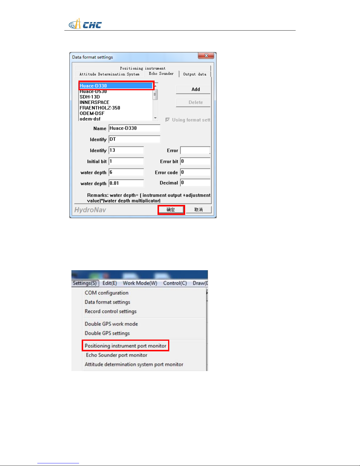
3. Change to “Echo Sounder” tab select “Huace-D330” click “OK” button.
Page 17
Shanghai HuaCe Navigation Technology Ltd.
15
5.4. Signal Test
1. Click “Settings” menu “Positioning instrument port monitor”.
2. In the pop-up “GPS COM monitor” window click “Start” button check
whether the GPGGA data continuously appear in the display window which
means the Rover receiver has successfully output the GPGGA data to the
software click “Close” button to quit this window.
Page 18

Shanghai HuaCe Navigation Technology Ltd.
16
3. In the main interface, the water depth is also displayed to the left side which
means the water depth data has been successfully transmitted from the
bathymetric software.
5.5. Drawing a Route
1. Click “Working Mode” menu “Drawing mode”.
Page 19

Shanghai HuaCe Navigation Technology Ltd.
17
2. Click button on the tool bar successively enter the coordinates of the
points that can form a region covering your planned route (also, you could move
the cursor to define those points) after enter the last coordinates right click
and choose “closure” option.
Page 20

Shanghai HuaCe Navigation Technology Ltd.
18
3. Click button on the tool bar move the cursor on the outline of the
coverage area and click on it the “Regional line deployment parameter
setting” window will pop up configure the azimuth angle (unit: degree) and
gap between the two line (unit: meter) click “OK” button.
Azimuth angle
Gap
Page 21

Shanghai HuaCe Navigation Technology Ltd.
19
5.6. Carry Out Measurment
1. Click “Settings” menu click “Record control settings” submenu.
2. The “record control setting” window will pop up determine the record
method.
Page 22

Shanghai HuaCe Navigation Technology Ltd.
20
3. Click “Settings” menu click “Adjustment of antenna deviation” submenu.
4. The “Antenna deviation adjustment” window will pop up configure height
from the antenna phase center of Rover receiver to the water level click “OK”
button.
Page 23

Shanghai HuaCe Navigation Technology Ltd.
21
5. Click “Working Mode” menu “Measurement mode”.
6. Click button on the tool bar the “confirm scan line name” window will
pop up configure the line name that you want to start record click “OK”
button the software will record the bathymetric data by the record method
that you configured before.
Page 24

Shanghai HuaCe Navigation Technology Ltd.
22
7. When you finish the data recording on one line click button on the
tool bar to change to another line the “confirm scan line name” window will
pop up configure the line name that you want to start record click “OK”
button the software will record the bathymetric data by the record method
that you configured before.
8. When you finishes all the recording click “Working Mode” menu select
“Drawing mode” click button to save the project exit the project.
9. You can find the data that recorded in ***.dep format in the folder that you save
your project for post-process.
Page 25

CHC - Shanghai HuaCe Navigation Technology Ltd.
Building C, NO. 599 Gaojing Road,
Qingpu District, 201702 Shanghai, China
Tel: +86 21 542 60 273
Fax: +86 21 649 50 963
Email: [email protected] | [email protected]
Website: www.chcnav.com
 Loading...