

Page 1

Autodesk®
Topobase
™
See the big picture.
Page 2
Make Better Decisions
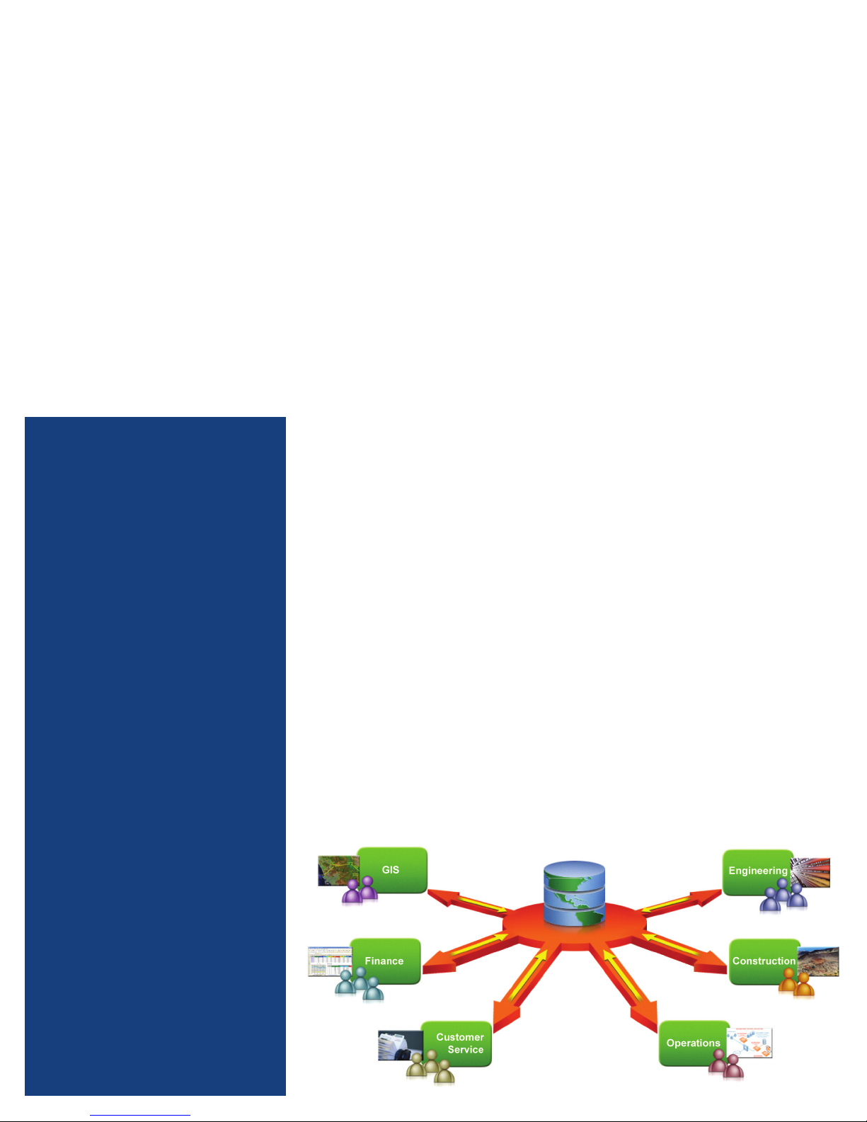
By providing an integrated view of CAD, asset, GIS, and
customer information, Autodesk® Topobase™ software
helps improve inefficient processes and data quality,
while enabling you to share up-to-date spatial information
throughout your organization.
Used Around the World
Australia:
MidCoast Water
Canada:
Innisfil Hydro
Germany:
ÜZ Lülsfeld
Henkel
Stadtwerke GmbH and Stadtische Betriebe
Fulda Gas and Water Supply
Hungary:
Bácsvíz Zrt.
Budapest District Land Oce
Sweden:
Tekis
Switzerland:
City of Chur
Industrielle Werke Basel
Romande Energie
Rhaetian Railway
Infrastructure Design and Management
Autodesk Topobase infrastructure model
management software helps to provide more
accurate information about the location and
status of your assets throughout your organization.
Built on AutoCAD® Map D software, Autodesk
MapGuide® Enterprise software, and Oracle®
software, Topobase helps you improve eciency
by consolidating isolated stores of computer-aided
design (CAD) and geographical information
system (GIS) data into a central spatial
information database.
As a result, Topobase helps free you from
time-consuming manual steps and conversion
processes that often introduce mistakes and
reduce precision.
Topobase is an integrated system that helps
manage events that take place during the entire
lifecycle of your assets. For example, when your
organization needs to replace an aging section
of water utility pipe, with help from Topobase,
engineers are able to create construction plans
for the project, determine which residents must
be notified, and schedule the work. Field sta
replace the pipe and engineers add relevant as-built
information and register the project as complete—
all within a single software environment.
More Flexible, Open Architecture
Autodesk Topobase is an open framework that
adheres to the specifications set forth by the Open
Geospatial Consortium (OGC) and is designed
for easier customization. As a result, Topobase
supports specific data requirements and business
processes—data fields, workflows, business rules,
dialog boxes, and user access permissions—without
software programming or database expertise.
The spatial information managed by Topobase
can be integrated with most existing business
systems using standard IT tools, without the need
for expensive proprietary tools or middleware.
Topobase helps make it easier to consolidate spatial
information with data from customer relationship
management (CRM), GIS, or other enterprise
systems, providing a more comprehensive view
of your infrastructure.
United States:
Las Vegas Valley Water District
Kansas City Board of Public Utilities
St. Paul Department of Public Works
Page 3

Improve Responsiveness
Provide field forces with the information they need to help
resolve service requests quickly.
Autodesk Topobase infrastructure model
management software provides visibility into
valuable design, GIS, and asset data. A single
source of information helps reduce operational
roadblocks by enabling users to access the data
they need, when they need it.
Quicker Return on Investment
Autodesk Topobase provides industry-specific
modules for managing infrastructure assets,
helping enable more rapid implementation
and a quick return on investment.
Each module—water, wastewater, gas, electric and
land—includes a detailed data model that can be
configured to better capture the exact information
you need regarding your infrastructure assets.
Workflows help reduce steps when designing
new infrastructure, and business rules provide
more security and consistency as users in separate
departments update the database. And the
multiple display models enable each user to view
the information with the scale, symbols, and
formatting most relevant to them.
Improve Processes and Data Access
Purchased by utilities, municipalities, and
government agencies that manage electricity,
gas, water, sewer, land, road, and rail
infrastructure assets, Autodesk Topobase is
used in more than 500 companies worldwide.
With help from Topobase, organizations can
integrate CAD and GIS information into an
infrastructure model for a more comprehensive
view of their assets; improve eciency and
data quality by minimizing manual data input
and standardizing data capture processes; and
use Autodesk® design information throughout
the infrastructure asset life cycle. In addition,
the software provides secure access to CAD,
GIS, and asset information to departments that
may not have had access before, such as field
operations, customer service, and finance.
Consulting Services from the Experts
To help you get more from your investment,
Autodesk oers consulting and partner services
to help implement Topobase more quickly and
successfully. Autodesk Consulting and partner
services can assist you with data migration,
configuration, implementation of local standards,
and interfacing with existing systems.
Page 4

With Topobase, it’s much easier to report, plan, and make smart
operational decisions. It even made a quick contribution to our
bottom line. Before, we were under billing telephone and cable
companies for pole attachments. We didn’t have an ecient way
to track them. Now, we are billing more accurately and seeing
more revenue. It all contributes to our goal of delivering reliable
service for a low rate.
— Pat Morrill
Director of electrical engineering
Kansas City Board of Public Utilities
Learn More or Purchase
Access specialists worldwide who can provide product expertise, a deep
understanding of your industry, and value that extends beyond your software
purchase. To purchase Autodesk Topobase software, contact an Autodesk
Premier Solutions Provider or Autodesk Authorized Reseller. Locate a reseller
near you at www.autodesk.com/reseller.
Autodesk Learning and Education
From instructor-led or self-paced classes to online training or education
resources, Autodesk oers learning solutions to fit your needs. Get expert
guidance at an Autodesk Authorized Training Center (ATC®) site, access
learning tools online or at your local bookstore, and validate your experience
with Autodesk certifications. Learn more at www.autodesk.com/learning.
Autodesk Services and Support
Help accelerate return on investment and optimize productivity with
companion products, consulting services, and support from Autodesk
and Autodesk authorized partners. Designed to get you up to speed
and keep you ahead of the competition, these tools help you make the
most of your software—no matter what industry you are in. Learn more
www.autodesk.com/servicesandsupport.
Autodesk Subscription
Autodesk® Subscription gives you immediate access to software
upgrades and exclusive access to service and support benefits designed
to help you get the most out of your Autodesk software. Learn more
www.autodesk.com/subscription.
This brochu re is printed on 100 percent postco nsumer waste recycled paper.
Autodesk , AutoCAD, ATC, Auto desk MapGuide, a nd Topob ase are registered tra demarks or trademarks of
Autodesk , Inc., and/or its sub sidiaries and/or aliates in t he USA and/or other countr ies. All other brand
names, product nam es, or trademark s belong to their respe ctive holders. A utodesk reserve s the right to
alter produ ct and services o erings, and speci fications and pricing at an y time without notice, an d is not
responsib le for typographic al or graphical error s that may appear in this document. © 2010 Autode sk, Inc.
All rights reserved. BRCMZ
 Loading...