

Page 1

Autodesk®
LandXplorer® Products
Model infrastructure change.
Page 2
Better Planning. Better Design. Better Results.
Leverage existing investments in software and data by
aggregating geospatial, civil engineering, computer-aided
design (CAD), building information modeling (BIM), and
utility network data in a single digital model. Use Autodesk
LandXplorer products to help improve decision making,
lower costs, view and share changes, and avoid the expense
of creating physical models.
Cities, utilities, property developers, and the
public are all seeking a better way to experience,
understand, and collaborate on infrastructure
projects and urban design. Imagine being able to
experience more real-world project scenarios and
share them with stakeholders before construction.
Whether you need to create models of small- or
large-scale city and infrastructure projects,
Autodesk
with visualization tools to help you make better
decisions throughout the design lifecycle.
®
LandXplorer® products provide you
The Autodesk LandXplorer products help you to:
• More easily realize additional ROI on existing
data and software by leveraging your existing
investments in Autodesk
data. Aggregate dierent levels of geospatial
(GIS), civil engineering (CAD), building (BIM),
and utilities detail in a single model.
• Reduce the cost of the design process by
minimizing the need for costly physical models.
• Enable design stakeholders to explore and
interact with 3D city and infrastructure
models by sharing visualizations and creating
a common environment that helps foster
collaboration.
®
design software and
Autodesk LandXplorer Studio Professional
Autodesk
software helps make it easier to create, manage,
and distribute digital city models; infrastructure
models; landscape models; and virtual D
environments. With help from Autodesk
LandXplorer Studio Professional, build more
accurate and visually compelling models and
create presentation-quality video and imagery
to share with stakeholders.
Figure 2: Create more informative city models by
combining scanned maps with detailed building mo dels.
®
LandXplorer® Studio Professional
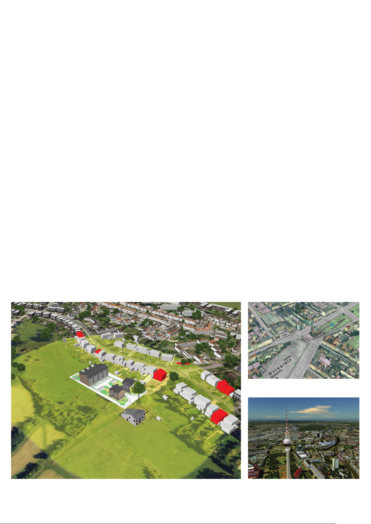
Figure 1: Inco rporate detailed 3D b uilding models along with d ata prepared in AutoCAD® Map3D sof tware into your city
model to bet ter illustrate aecte d residential buildings wit hin 100 meters of a pro posed development .
Figure 3: Aerial vi ew of a digital city model of Be rlin.
Page 3

Discover. Comprehend. Decide.
With help from Autodesk LandXplorer products, you can
more easily create and explore digital city and infrastructure
models to better conceptualize and visualize design projects
before they are built.
Autodesk LandXplorer Server
Autodesk
more dynamic visualizations of large-scale, D city
and infrastruc ture models over the web. Model
data is processed with Autodesk LandXplorer
Studio Professional and published to the web using
LandXplorer Server where it can then be shared
with internal and external audiences, helping
to provide project reviewers, stakeholders, and
team members with the ability to view and gather
information about proposed infrastructure and
urban development and renovation plans using a
standard web browser.
Figure 4: Combine GIS data prep ared in AutoCAD Map
3D softw are and roads designed in A utoCAD
3D
interchange.
®
LandXplorer® Server software provides
®
®
software to better visualize a p roposed highway
Civil
Display, Explore, and Share City Models
Autodesk LandXplorer Server and Autodesk
LandXplorer Studio Professional can help provide
several advantages for planning changes to
the built and natural environment. Using these
products to construct a D model of a project can
help you to better conceptualize and visualize
design projects before they are built. LandXplorer
products can minimize the need for costly physical
models of projects and enable you to view and
highlight changes on screen. You will be better
able to eectively share ideas and scenarios with
stakeholders by creating videos, high-resolution
scene renderings, and panoramas of your
project. And the ability to incorporate numerous
sources of data helps to more accurately visualize
infrastructure and illustrate the impact that
infrastructure change, urban planning, tourism,
or economic development projects have on a city
and the surrounding environment.
Figure 5: Them atically represent buildings with high
occupanc y levels within areas zoned as re sidential using
data held within the model.
Publish and share city models
more easily
Autodesk LandXplorer Xpress Viewer
With help from Autodesk
Xpress Viewer software, you can more
securely and rapidly share your city and
infrastructure models, with customizable
functionality, in packaged LandXplorer
Xpress Viewer project files. Navigate and
explore the model and search points of
interest. Measure straight-line distances
and create snapshots, panoramas, and
videos of the model. Autodesk LandXplorer
Xpress Viewer is available as a free*
download from www.autodesk.com/
landxplorer.
Autodesk LandXplorer CityGML Viewer
With help from Autodesk
CityGML Viewer software, view CityGML
data sets without licensing additional
software. Autodesk LandXplorer CityGML
Viewer is available as a free* download
from www.citygml.org.
Autodesk LandXplorer Publisher
With help from Autodesk
Publisher software, share visualizations
with key stakeholders more rapidly by
publishing digital city models to KML
format for use in Google Earth™ or
Microsoft
Autodesk LandXplorer Publisher
is available as part of Autodesk
LandXplorer Studio Professional.
®
Virtual Earth® applications.
®
LandXplorer®
®
LandXplorer®
®
LandXplorer®
Page 4

Cities, utilities, property developers, and the public are all
seeking a better way to experience, understand, and collaborate
on infrastructure projects and urban design. With help from
Autodesk LandXplorer products, stakeholders from the public,
city government, construction, and business communities can
work together to visualize infrastructure projects before they
are built.
Learn More or Purchase
Access specialists worldwide who can provide product expertise, a deep
understanding of your industry, and value that extends beyond your software.
To license Autodesk LandXplorer software, contact an Autodesk Premier
Solutions Provider or Autodesk Authorized Reseller. Locate a reseller near you
at www.autodesk.com/res el ler.
Autodesk Learning and Education
From instructor-led or self-paced classes to online training or education
resources, Autodesk offers learning solutions to fit your needs. Get expert
guidance at an Autodesk Authorized Training Center (ATC
learning tools online or at your local bookstore, and validate your experience
with Autodesk certifications. Learn more at www.autodesk.com/learning.
Autodesk Services and Support
Help accelerate return on investment and optimize productivity with
companion products, consulting services, and support from Autodesk
and Autodesk authorized partners. Designed to get you up to speed and
keep you ahead of the competition, these tools help you make the most
of your software—no matter what industry you are in. Learn more at
www.autodesk.com/servicesandsupport.
Autodesk Subscription
Autodesk
upgrades and exclusive access to service and support benefits designed
to help you get the most out of your Autodesk software. Learn more at
www.autodesk.com/subscription.
*Free prod ucts are subject to t he terms and conditions of t he end-user license agr eement that accompanie s
download o f this software.
Autodesk , AutoCAD, ATC, Civil D, and LandXplorer are regis tered trademarks or trademark s of Autodesk,
Inc., an d/or its subsidiaries and /or aliate s in the USA and/or other countries. All other brand names ,
produc t names, or tradema rks belong to their res pective holder s. Autodesk reser ves the right to alter
produc t and services oer ings, and specific ations and pricing at any time without notice, and is not
responsib le for typographic al or graphical error s that may appear in this doc ument.
© 2010 Autodesk, Inc . All rights reserved. BRCMZ
®
Subscription gives you immediate access to software
®
) site, access
 Loading...