

USER MANUAL
MappyField
Version: 5.0
Compatibility:
Dynamics 365 (v9.0) and above

USER MANUAL: DynamicsCRM Mappyfield
BIZ/UMP/G1 Public 2
TABLE OF CONTENTS
Introduction ........................................................................................................................ 5
Benefits of MappyField ....................................................................................................... 5
Prerequisites ....................................................................................................................... 5
Installation & Activation ...................................................................................................... 6
Installation Steps ......................................................................................................................... 6
Activate Your Free Trial ............................................................................................................... 8
Activation .................................................................................................................................. 10
Insert License Key ...................................................................................................................... 11
Setup for Admin ................................................................................................................ 12
Default Configurations (Setup).................................................................................................. 12
Configure Languages ................................................................................................................. 14
Assign User Role ........................................................................................................................ 15
User Wise Map Configuration ................................................................................................... 16
Security Template Configuration .............................................................................................. 19
Entity Mappings ................................................................................................................ 21
Geocode Records .............................................................................................................. 27
Manually Geocode the Record .................................................................................................. 27
Non-Geocoded Records ............................................................................................................ 29
Individual Records on Map View ...................................................................................... 30
MappyField section in Record Details ....................................................................................... 30
View Map from Entity Menu ..................................................................................................... 32
Map View .......................................................................................................................... 33
Default Location ................................................................................................................................. 35
Plot the records on Map............................................................................................................ 36
Select Entity ........................................................................................................................................ 36
Pin selection for records ..................................................................................................................... 38

USER MANUAL: DynamicsCRM Mappyfield
BIZ/UMP/G1 Public 3
Cluster Map Records .......................................................................................................................... 39
Advance Options ....................................................................................................................... 41
Marketing List ..................................................................................................................................... 41
Point of Interest (POI)......................................................................................................................... 42
Category Search .................................................................................................................................. 43
Summary Card .................................................................................................................................... 44
Search Options .......................................................................................................................... 45
By Region ............................................................................................................................................ 46
By Drawing.......................................................................................................................................... 47
By Territory ......................................................................................................................................... 48
By Proximity ........................................................................................................................................ 49
By User................................................................................................................................................ 49
Layer Menu ................................................................................................................................ 50
Save Template ........................................................................................................................... 52
Map View options ..................................................................................................................... 53
Tooltip Details .................................................................................................................................... 54
Add to Origin ...................................................................................................................................... 56
Add to Destination ............................................................................................................................. 57
Send Email using Template ................................................................................................................ 58
Assign Owner ...................................................................................................................................... 58
Assign to Marketing List ..................................................................................................................... 59
Proximity Search ................................................................................................................................. 60
Add Task ............................................................................................................................................. 62
Add Appointment ............................................................................................................................... 63
Point of Interest .................................................................................................................................. 64
Related Records .................................................................................................................................. 65
Delete Record ..................................................................................................................................... 66
Deactivate Records: ............................................................................................................................ 67
Qualify Lead ........................................................................................................................................ 67
Reactivate Lead .................................................................................................................................. 69
Direction .................................................................................................................................... 70

USER MANUAL: DynamicsCRM Mappyfield
BIZ/UMP/G1 Public 4
Multiple Routes .................................................................................................................................. 71
Email Route ........................................................................................................................................ 74
Save Route .......................................................................................................................................... 74
SPF (Shortest Path First) ..................................................................................................................... 76
Templates .................................................................................................................................. 77
Locations ................................................................................................................................... 79
Add New Location .............................................................................................................................. 79
Track User ........................................................................................................................................... 80
Data Grid ................................................................................................................................... 81
Add Record to Route .......................................................................................................................... 83
Assign to User/Team: ......................................................................................................................... 84
Send Email using Template ................................................................................................................ 85
Manage Territory................................................................................................................................ 85
Auto Schedule Records ....................................................................................................................... 86
Auto Schedule Records ............................................................................................................. 86
Check-Ins/Check-Outs ............................................................................................................... 90
Contextual Menu ....................................................................................................................... 93
Territory Management .............................................................................................................. 94
Heat Map ................................................................................................................................... 98
Analytical Dashboard ...................................................................................................... 101
MappyField Reporting Dashboard .......................................................................................... 101
MappyField Reporting Dashboard .......................................................................................... 102
MappyField Sales Activity Dashboard ..................................................................................... 103
MappyField Sales Performance Dashboard ............................................................................ 103
MappyField Service Activity Dashboard .................................................................................. 104
Uninstallation Steps ........................................................................................................ 105
Contact Us ....................................................................................................................... 106

USER MANUAL: DynamicsCRM Mappyfield
BIZ/UMP/G1 Public 5
Introduction
MappyField Dynamics CRM plugin provides geo-analytical solutions to CRM users and helps them to plot
CRM data in maps. It lets user choose an entity, CRM or custom view to plot all individual records from
that entity on the map. You can map multiple entities, address related to customer entities at a time. Also,
you can save different user preferences as such map configurations, zoom levels, and views for future
references.
Benefits of MappyField
• Ease of access
• Plot any entity record on the map
• Concentric proximity Search across entities
• Build marketing list
• Qualify/Disqualify lead records
• Point of interest search
• Color code pushpins and heatmap
• Routing with multiple waypoints
• Auto Schedule Records
• SPF: Shortest Path First for Route
• User Tracking
• Ability to save & share driving directions
• Check-In & Check Out option for all Activities
• Sales analysis becomes easy with Opportunity and Sales Heat Map
• Dashboard support
• Seamlessly integrates within Dynamics CRM
Prerequisites
Following point must be followed before starting the Plugin installation:
• You should be logged into Dynamics CRM 2016 or Dynamics 365, Online or On-premises.
• You will have to generate Bing Map API key. How to generate Bing Map API Key?
USER MANUAL: DynamicsCRM Mappyfield
BIZ/UMP/G1 Public 6
Installation & Activation
Installation Steps
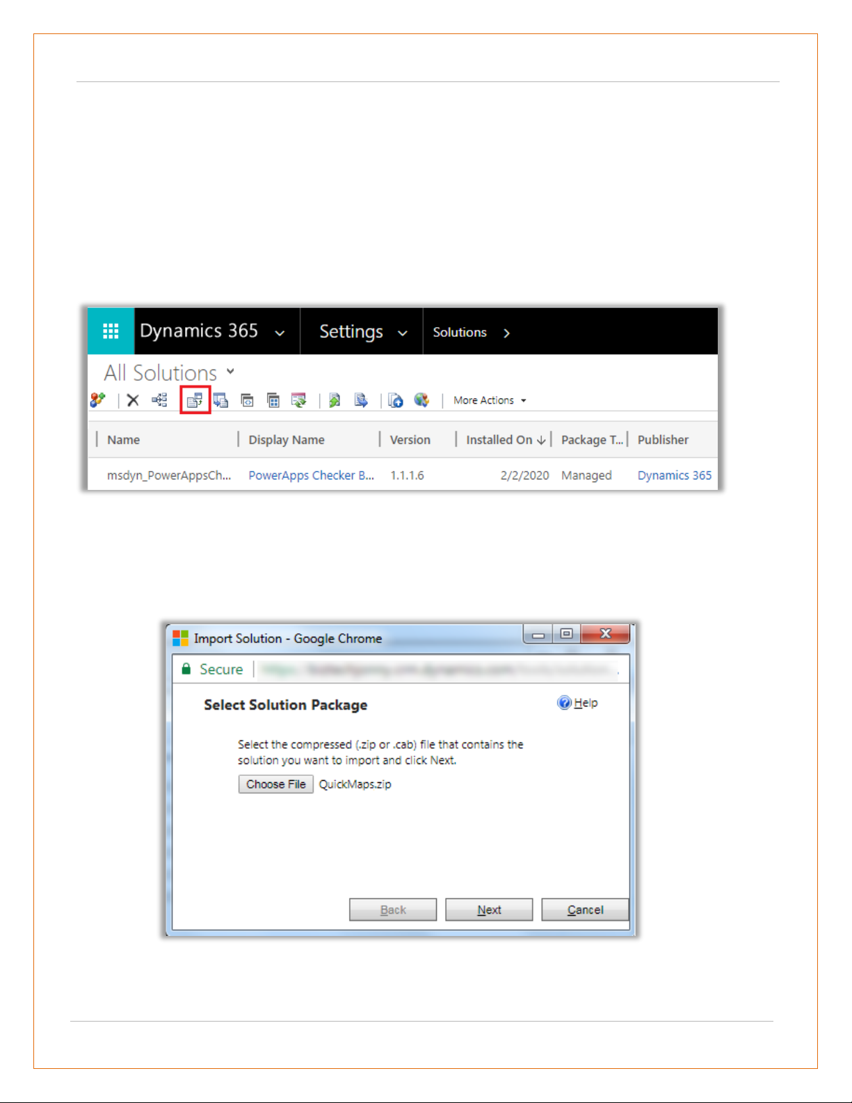
➢ To install ‘MappyField’ plugin, the following steps are to be followed:
• On purchasing the plugin, you will get a zip file named "QuickMaps.zip".
• Login into your CRM Account and click on Settings -> Solutions.
• Click on ‘Import’ to upload and install the Solution.
• Click on ‘Choose File’ button and choose the Package Zip File for MappyField from the Import
Solution Window.
• Click on ‘Next’ for further processing.
USER MANUAL: DynamicsCRM Mappyfield
BIZ/UMP/G1 Public 7
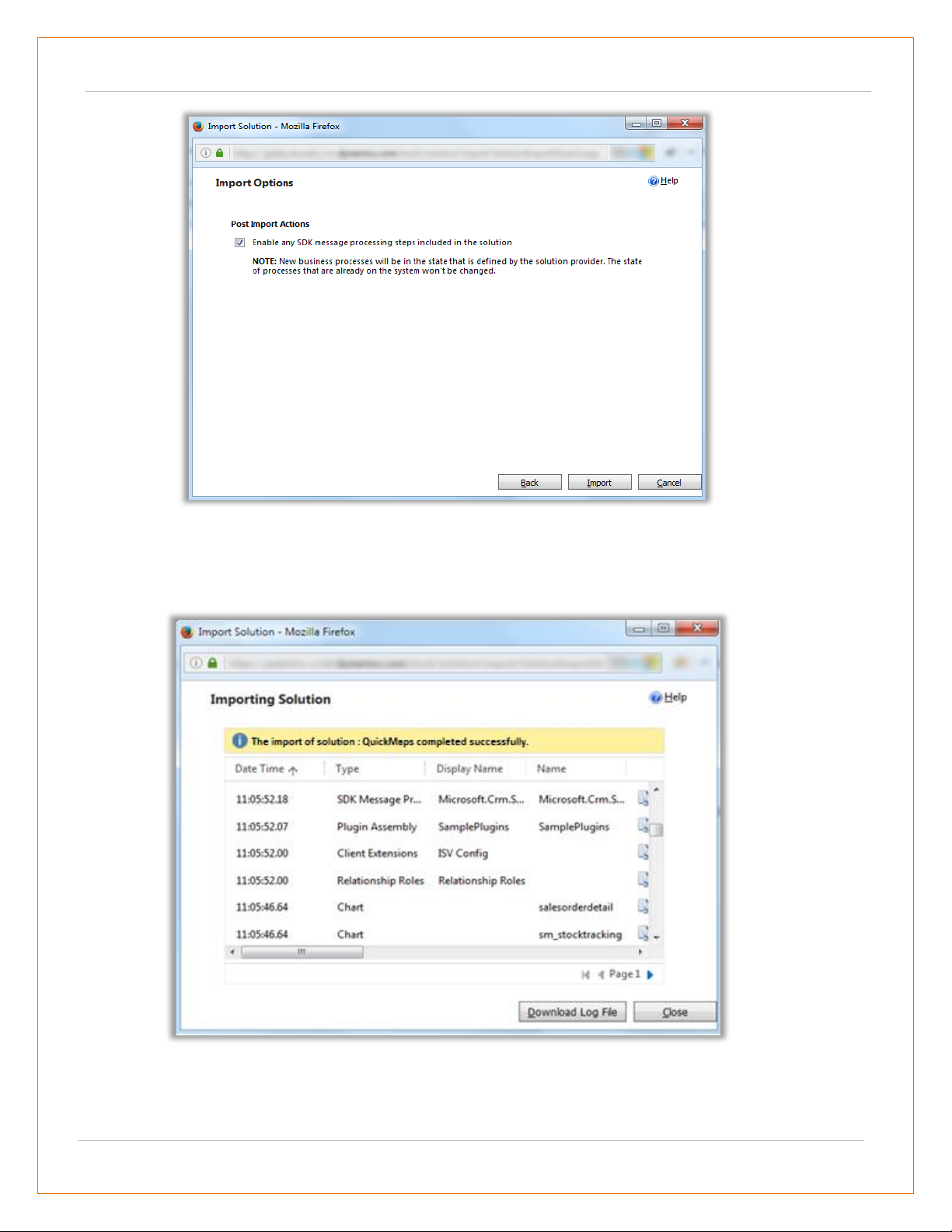
• Check the box to enable any SDK message processing steps included in the solution and click on
Import button to Import the Solution.
• Click on ‘Close’ after successful completion message is displayed.
USER MANUAL: DynamicsCRM Mappyfield
BIZ/UMP/G1 Public 8
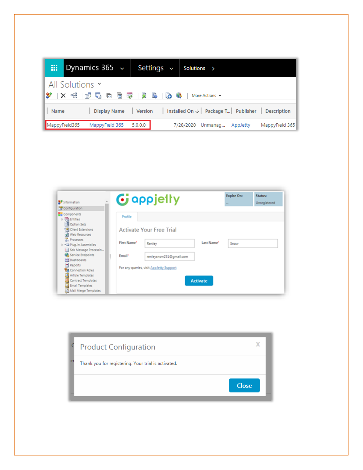
• Once you import the solution, it will be displayed in the solutions grid view.
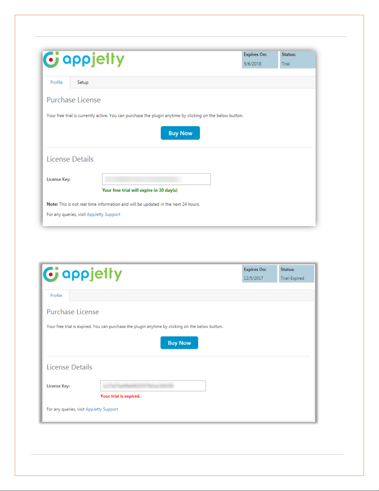
Activate Your Free Trial
• Double click on ‘MappyField’ solution to configure the plugin with your license key.
• This will open up a new window. Click on ‘Configuration’ from the options provided on the
left side.
• You can activate your one-month free trial.
• To get a one-month free trial license key, fill out the details and click on ‘Activate’ button.
• Your trial will get activated and expiry date will be displayed on top.
USER MANUAL: DynamicsCRM Mappyfield
BIZ/UMP/G1 Public 9
• You can purchase the licensed version any time. To purchase the license, click on ‘Buy Now’ button.
USER MANUAL: DynamicsCRM Mappyfield
BIZ/UMP/G1 Public 10
Activation
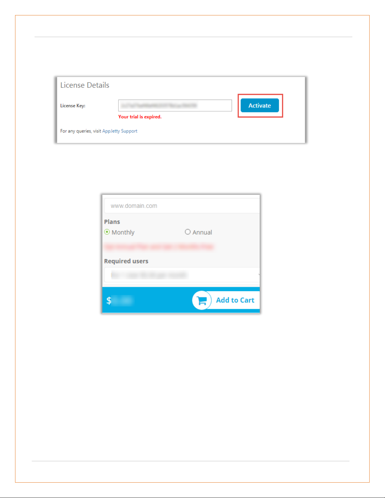
• On expiration of Trial, a message will appear that the Trial is expired.
• Now to purchase the license click on ‘Buy Now’ button.
• This will redirect you to our product page and a pop-up will appear. Click on ‘Add to Cart’
button and complete the purchase process.
• On successfully completion of the purchase process, you will receive your license key via
email along with steps to complete the license configuration.
USER MANUAL: DynamicsCRM Mappyfield
BIZ/UMP/G1 Public 11
Insert License Key
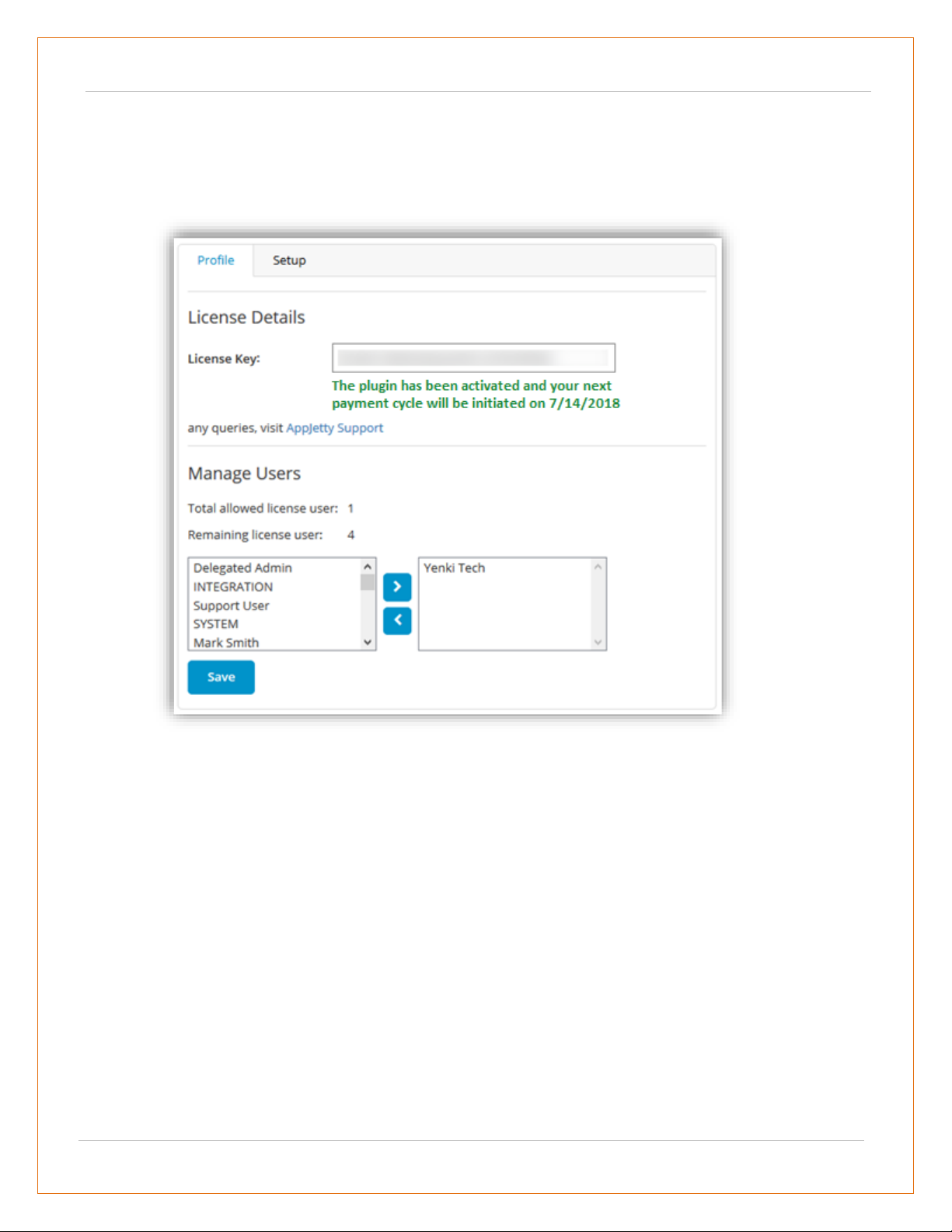
• Enter the New License key received in mail. This will enable the ‘Activate’ button.
• Click on ‘Activate’ button to activate your license.
• Default settings under set up tab can be managed only if a user has System Administrator Role,
AppJetty MappyField Admin. Or else it would show error message stating “You don’t have
administrative rights. Please contact administrator.”
USER MANUAL: DynamicsCRM Mappyfield
BIZ/UMP/G1 Public 12
Setup for Admin
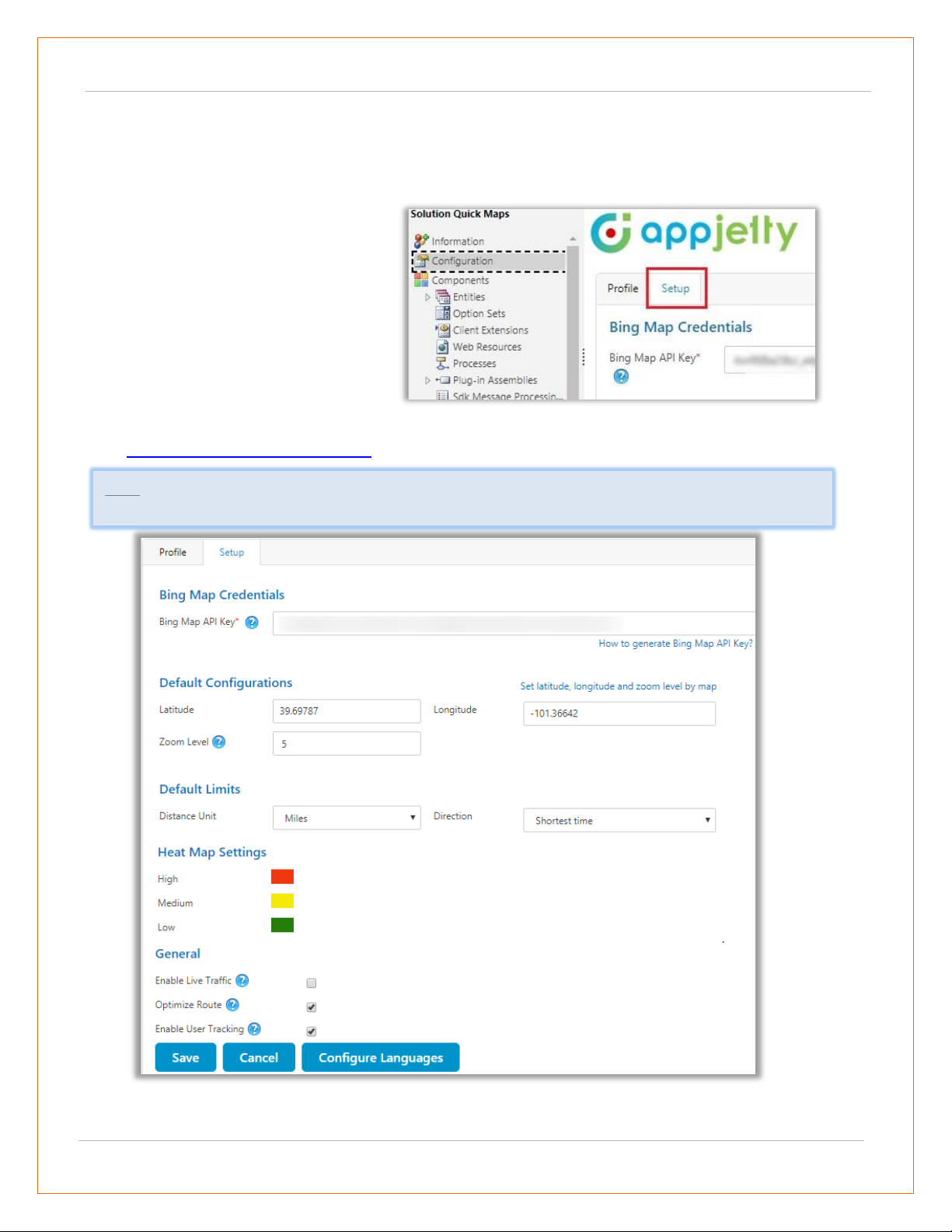
Default Configurations (Setup)
• Bing Map API Key: Enter Bing map API key which you have generated from
https://www.bingmapsportal.com/.
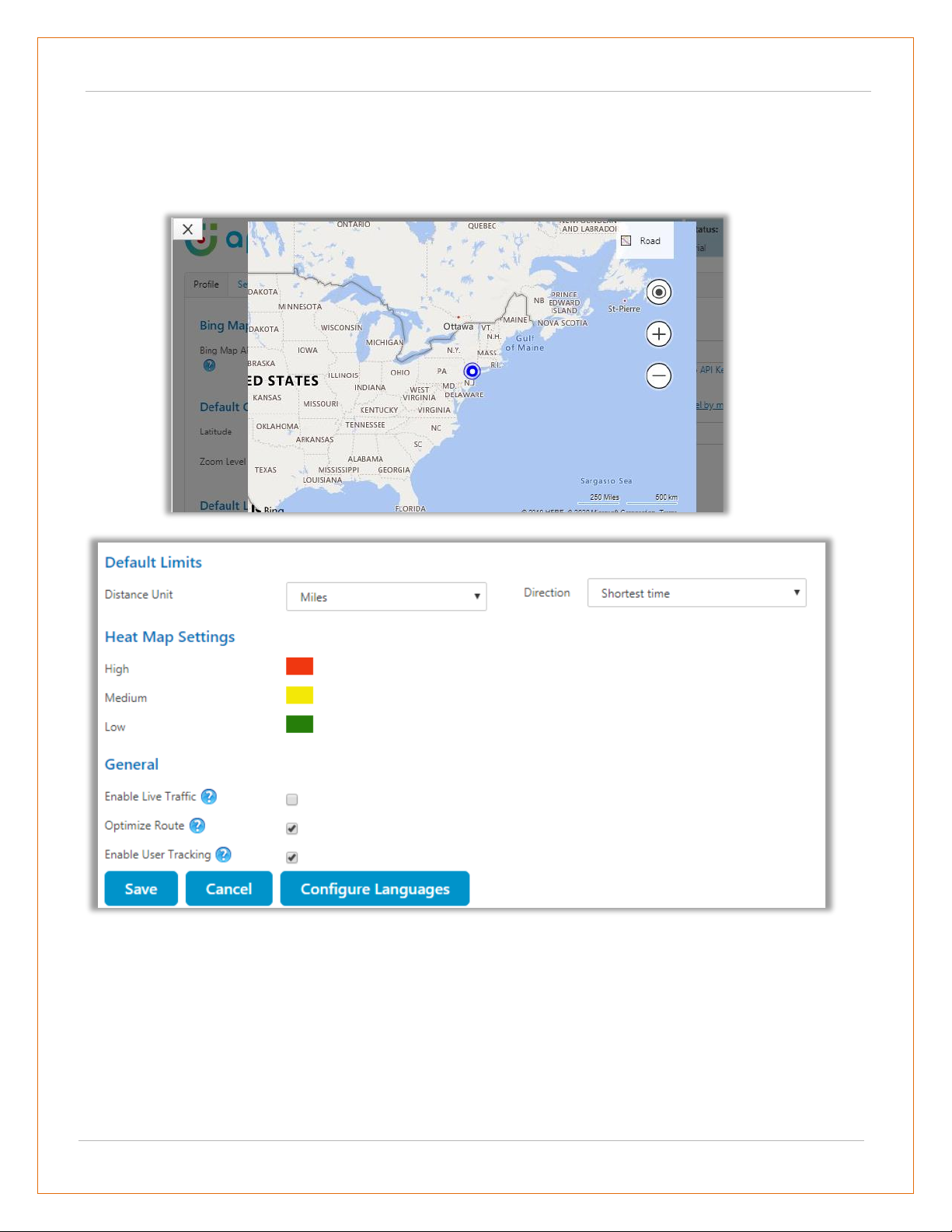
• Under “Default Configuration” option, set default Latitude, Longitude and Zoom level for map when
it is opened for the first time.
• To manage the default configuration
settings for Admin user, click on
‘Setup’ tab and enter default
configurations.
• Admin user can set the default view of
the map by configuring from here.
Note: To assist you further, we have added a link beneath the text box that states How to generate Bing
Map API Key.
USER MANUAL: DynamicsCRM Mappyfield
BIZ/UMP/G1 Public 13
• You can set the default location using the map as well by clicking on “Set latitude, longitude and
zoom level on map” option available on the right-hand corner.
• By clicking on it, the map will open in new window. You can set the location by moving the icon as
shown in below screenshot.
• Set “Default Limits” for distance unit and direction. Distance unit can be in Kilometers or Miles and
Direction can be Shortest Time or Shortest Distance.
• You can also set colors for ‘Heat Map’ configuration which would indicate the intensity of the data.
i.e. High, Medium and Low.
• A user can also enable/disable Live traffic on Bing Maps and Optimize the route using SPF
(Shortest Path First) feature from the configuration.
• A user can enable/disable Live User tracking feature from configuration to track users.
USER MANUAL: DynamicsCRM Mappyfield
BIZ/UMP/G1 Public 14
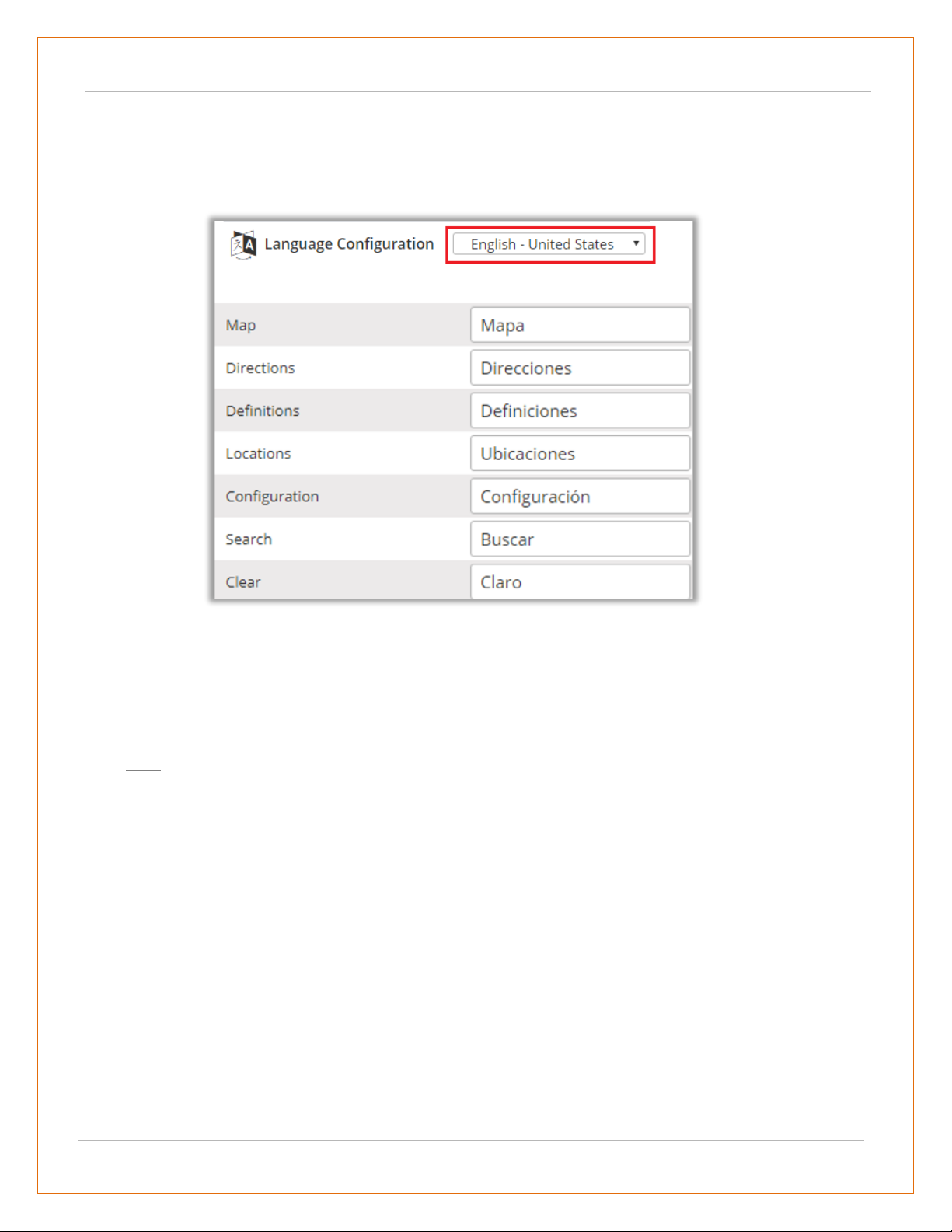
Configure Languages
• You can also configure language of your choice by clicking on Configure Languages button available
on Setup page.
• Select the language from dropdown that you wish to configure your messages.
• Here, user needs to add translations themselves for the messages in the language of their choice.
• Click on save button to save the language translations.
• Note: To configure languages, user first needs to manage language settings from CRM. Languages
that are selected in CRM can be configured for the MappyField.
USER MANUAL: DynamicsCRM Mappyfield
BIZ/UMP/G1 Public 15
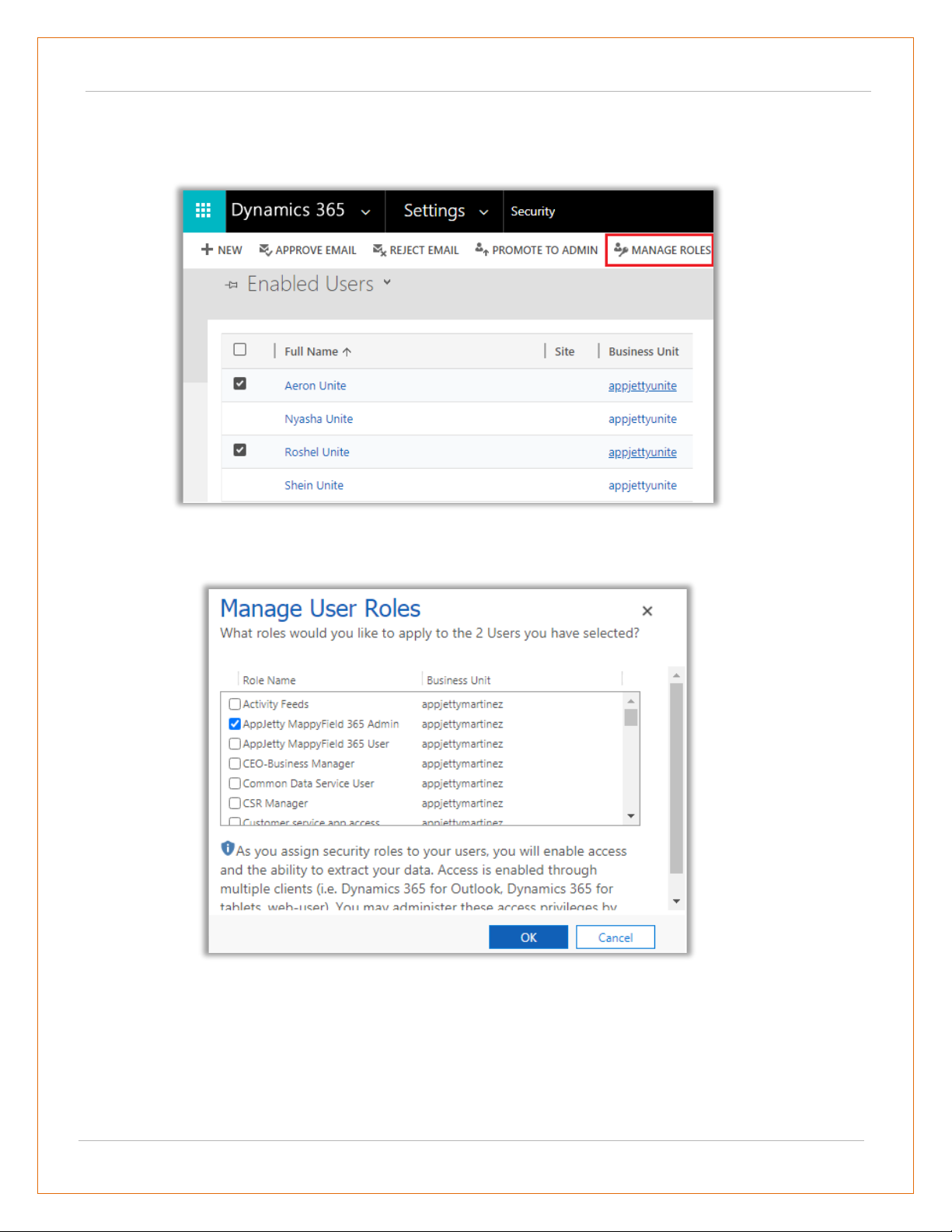
Assign User Role
• To manage the user roles, navigate to Settings -> Security -> Users.
• Now select the users whose roles are to be managed and click on ‘MANAGE ROLES.’
• This will open a pop up to select roles.
• The available roles for selection are AppJetty MappyField Admin or AppJetty MappyField User role.
• User with AppJetty MappyField Admin role can perform all the actions like System administrator
while user with AppJetty MappyField User role can do all actions except delete actions.
USER MANUAL: DynamicsCRM Mappyfield
BIZ/UMP/G1 Public 16
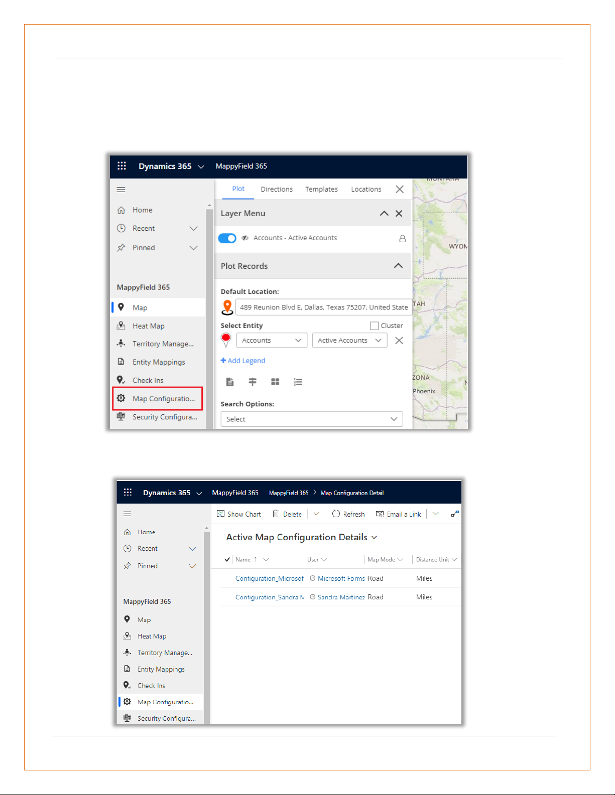
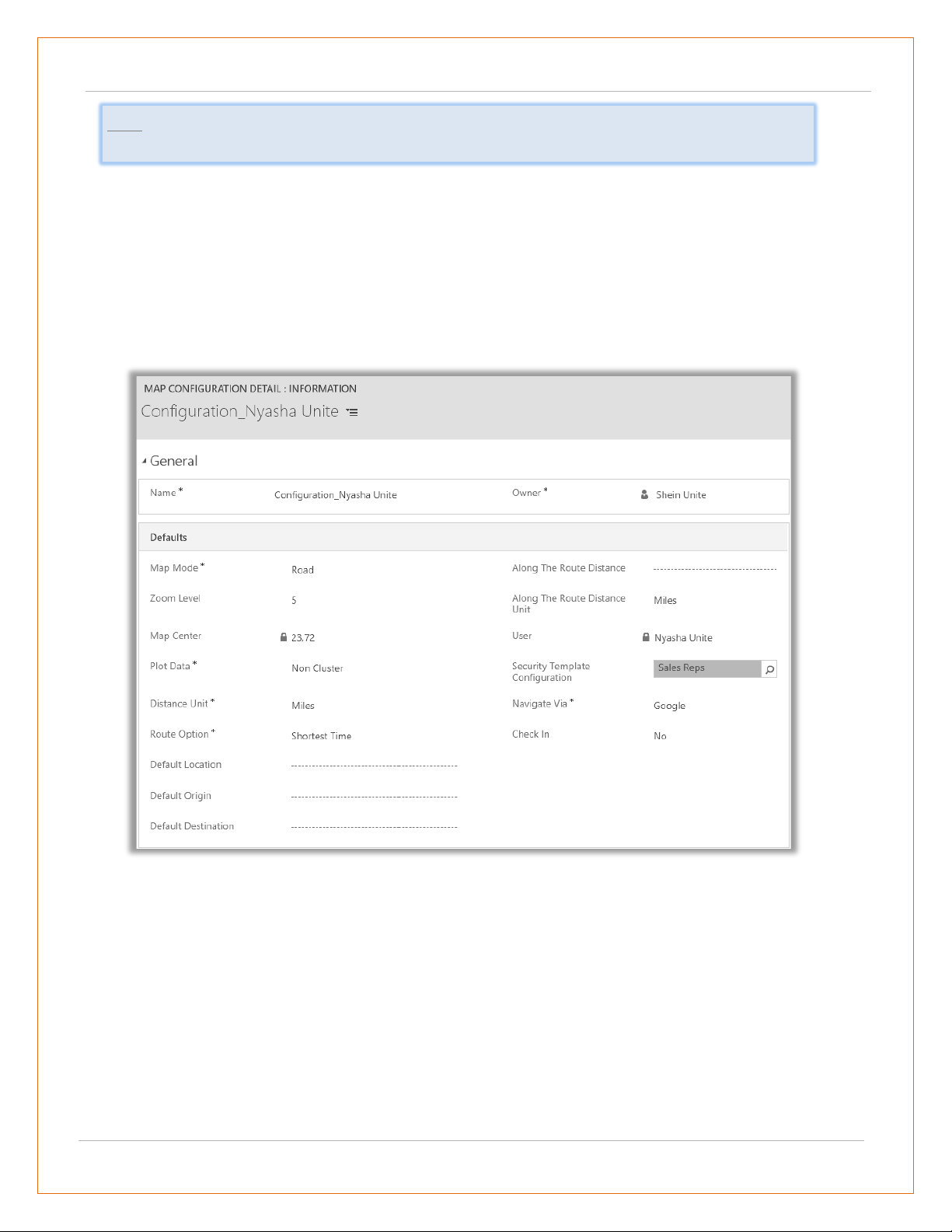
User Wise Map Configuration
• On assignment of any role like AppJetty MappyField Admin, AppJetty MappyField User or System
Administrator role, configuration settings record must be created. This can be accessed by
navigating to Map Configuration.
• On navigating to MappyField Configuration, it would show list of all the users with Quick Map role
or System Administrator.
USER MANUAL: DynamicsCRM Mappyfield
BIZ/UMP/G1 Public 17
• Following are the configurations:
▪ Map Mode: User can select default map mode. It can be road or aerial mode.
▪ Zoom Level: User can set default zoom level for the map. It can also be managed based on
settings made from the contextual menu.
▪ Plot Data: Default plotting of data can be defined. Either it can be in cluster or non-cluster
format.
▪ Distance Unit: Default option for distance measuring. Either miles or kilometers.
▪ Route Options: You can define best way to determine route from this feature.
▪ Default Location: The user can define the default location using this option.
▪ Default Origin: The user can define the default origin using this option. It can also be
managed based on settings made from the contextual menu.
▪ Default Destination: The user can define the default destination using this option. It can
also be managed based on settings made from the contextual menu.
▪ Along the route distance: Define radius of along the route search.
▪ Along the route distance unit: Define default unit for along the route search.
Note: These configurations are default user-based configurations that will be set as default when
map is loaded.
USER MANUAL: DynamicsCRM Mappyfield
BIZ/UMP/G1 Public 18
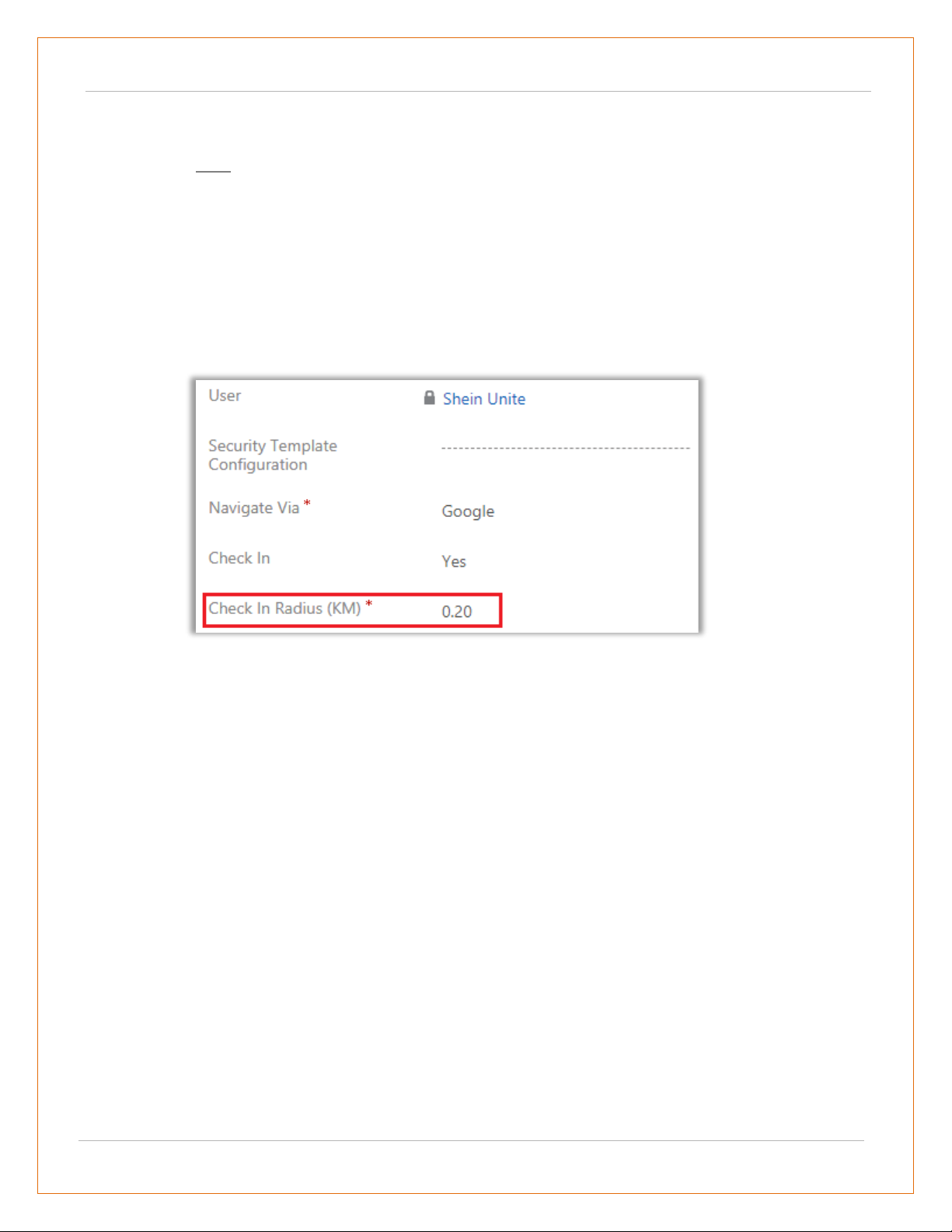
▪ Security Template Configuration: Define the default Security Template for the user if
required.
Note: Here the list of the Templates will appear as per the Security Template
Configurations.
▪ Navigate via: Select navigate to check the routes by using Google Maps, Waze Map or
Apple Map.
▪ Check In: Enable or disable the ‘Check In’ module. If you enable the Check In, Check In
Radius (KM), the option will get enabled.
▪ Check in Radius: Define Geo Radius that can be allowed to perform any check in.
USER MANUAL: DynamicsCRM Mappyfield
BIZ/UMP/G1 Public 19
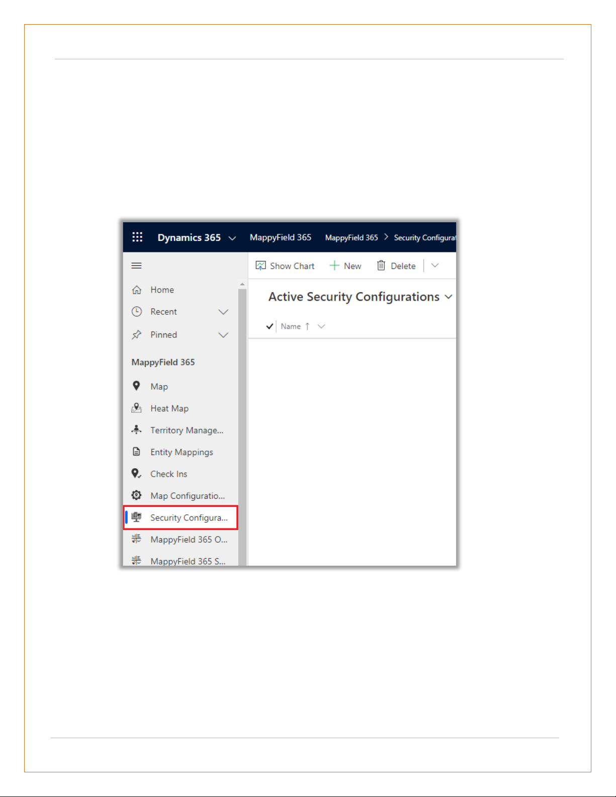
Security Template Configuration
• Only System administrator or User with AppJetty MappyField Admin role can create Security
Template for other CRM users with AppJetty MappyField User role.
• User admin can assign selected actions to different users using security templates.
• To create a ‘security template’, navigate to AppJetty -> Security Template Configuration.
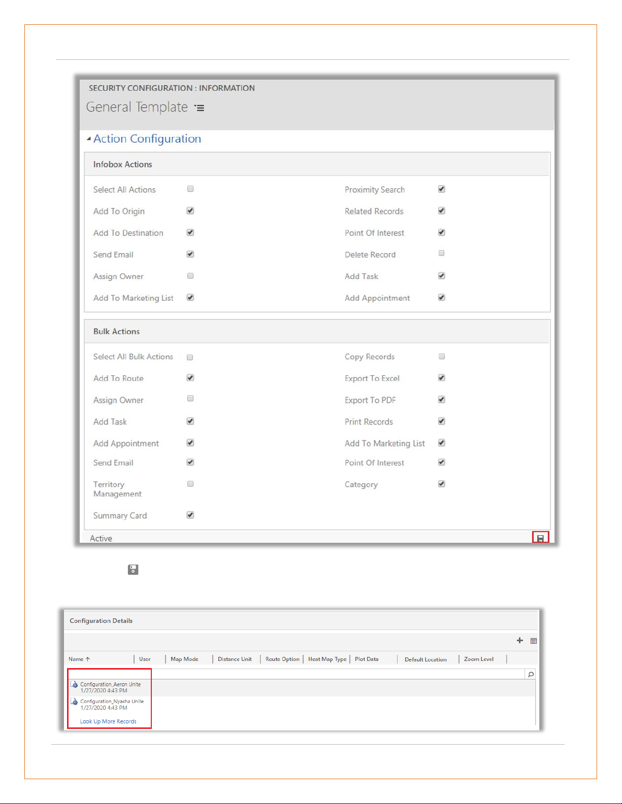
• Click on + New button from the action ribbon and enter template name and select all the actions
that you want to make available for users with that template.
USER MANUAL: DynamicsCRM Mappyfield
BIZ/UMP/G1 Public 20
Click on Save icon. Upon saving, it would enable Configuration Details section from where you can
directly assign that template to a user.
USER MANUAL: DynamicsCRM Mappyfield
BIZ/UMP/G1 Public 21
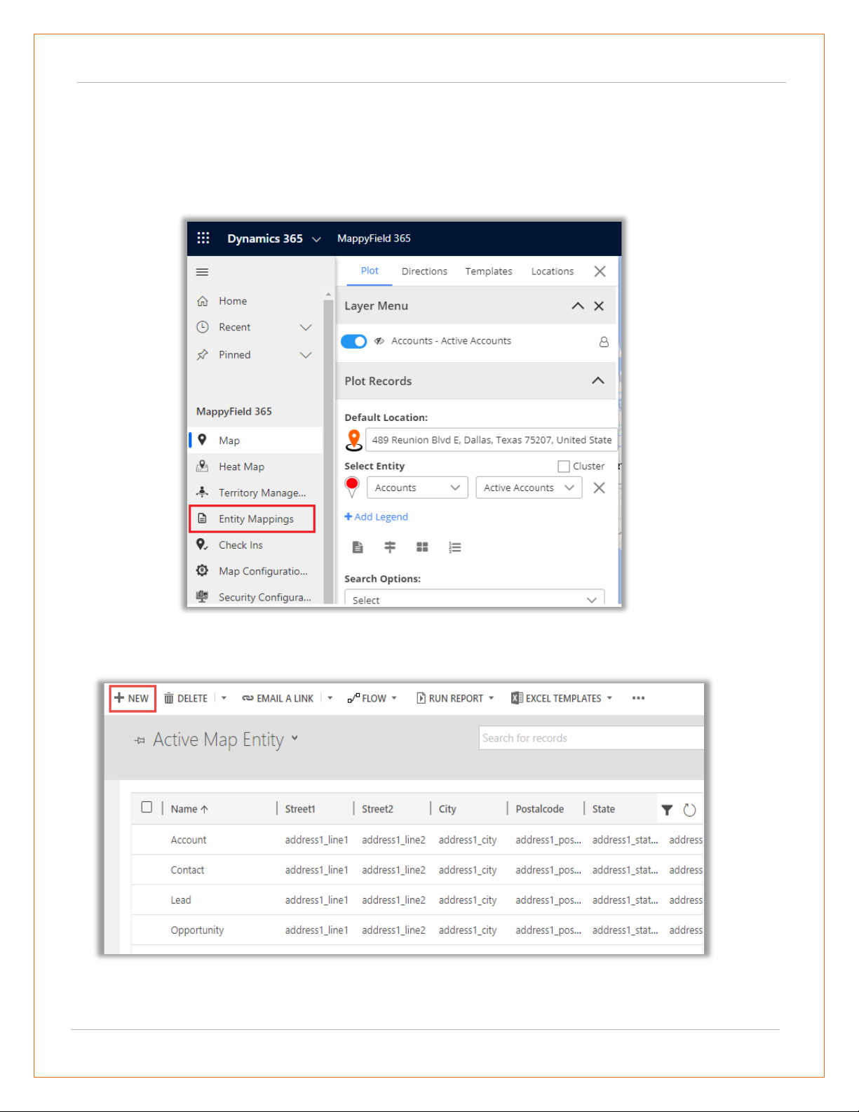
Entity Mappings
• Navigate to AppJetty -> Entity Mappings to display the entity with its relevant details on the
MappyField. From here you can add a new entity and configure its required details.
• By clicking on Entity Mapping, the list of entities can be seen which are already mapped.
• Click on “New” button, this will open a new window for mapping an entity.
USER MANUAL: DynamicsCRM Mappyfield
BIZ/UMP/G1 Public 22
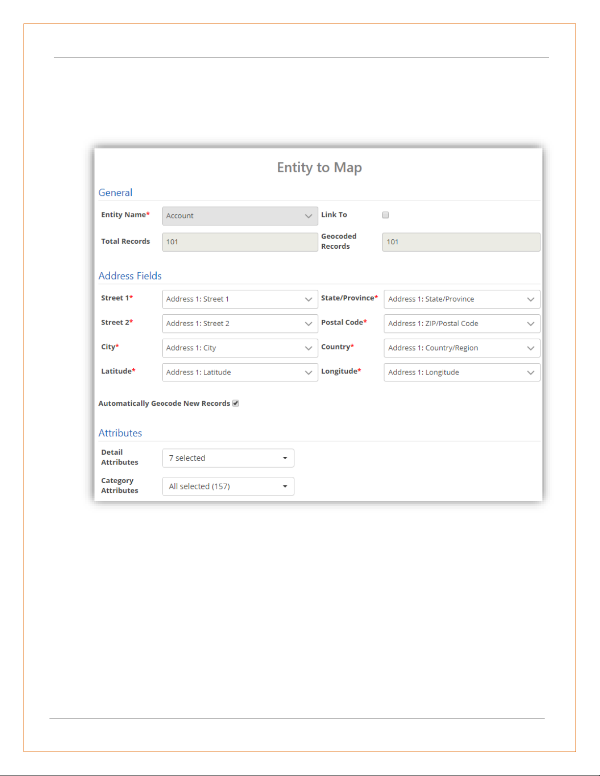
• Entity Name: Select the entity you want to map. You can choose from all the entities that are
present in the CRM by default or the custom entities created by you.
• Link To: Check the link to option to link the selected entity to some other entity. After checking
the box, you will get a list of relationships with which you can link the selected entity.
• Activity Entities work only on Account, Contact or Lead addresses marked as regarding address.
• Total Records: It displays how many records the entity contains.
• Geocoded Records: It displays how many records are geocoded.
• Address Fields: Select the address fields for the entity, to be used for geocoding. By default, it will
consider map’s certain address fields. If needed they can be changed.
• Automatically Geocode New Records: If it is checked, it geocodes the record automatically as per
saving configuration.
• Once you have filled all details, click on “Save” button. Entity will be mapped, and success/failure
message will be displayed.
USER MANUAL: DynamicsCRM Mappyfield
BIZ/UMP/G1 Public 23
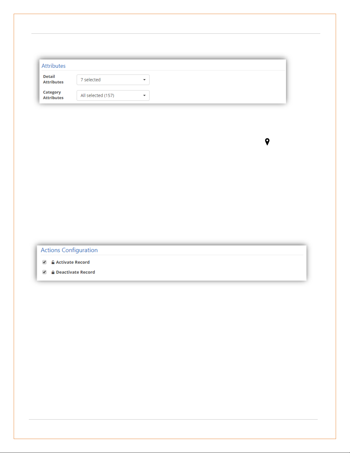
Attributes
• For mapped entities, further configurations can be managed like Attributes. It includes Detail
Attributes and Category Attributes.
• ‘Detail attributes’ are the ones that appear on card upon clicking on ‘pushpin pointer’ . At max 10
attributes can be selected.
• ‘Category attributes’ are the ones that appear in dropdown for ‘category’ selection. You can select
as many attributes as you want for category selection.
Action Configuration
• For mapped entities, you can edit action configuration section where you can check/uncheck the
action buttons according to your requirement.
• This will reflect on the tooltip card. Here, only those action buttons will be shown that can be
changed. Default buttons will not be shown in this configuration section.
USER MANUAL: DynamicsCRM Mappyfield
BIZ/UMP/G1 Public 24
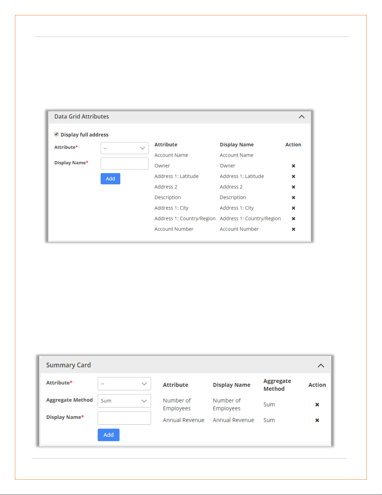
Data Grid Attributes
• From here, you can select the attributes for the data grid. When you plot any data in map or in heat
map, grid data will be displayed according to attributes selected here.
• If ‘Display Full Address’ checkbox is checked in data grid, it will display records with full address.
• You can select maximum 8 data grid attributes.
Summary Card Configuration
• You can make configurations related to what you want to display on summary card.
• For summary card of an entity, you can choose the attributes that you want from the dropdown list.
• Also, under aggregate method, you can define the way you want records to be summarized. It can
be either sum or average. Also, you may define display name of that attribute.
• By default, it is same as attribute name. All the selected attributes are shown in the list from where
it can be removed as well.
USER MANUAL: DynamicsCRM Mappyfield
BIZ/UMP/G1 Public 25
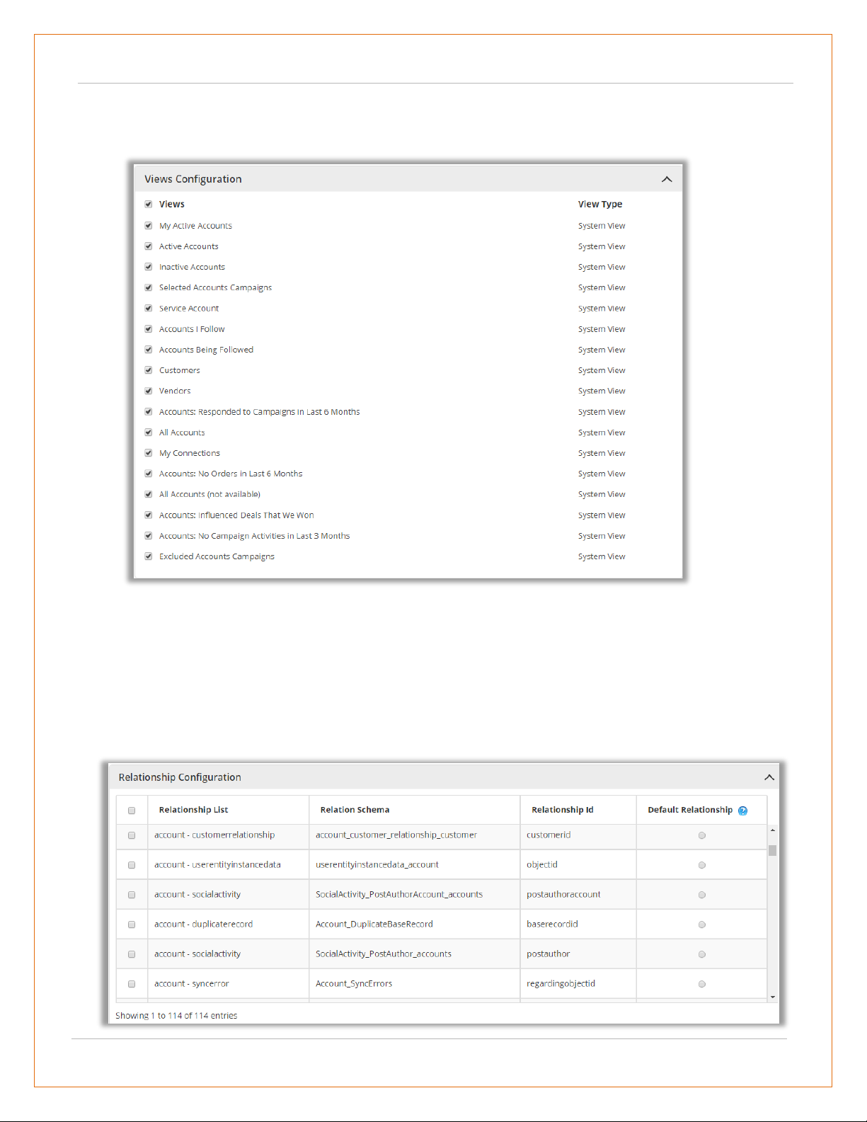
Views Configuration
• You can select the view that you want to display on the map for particular entity.
Relationship Configuration
• The selected relationship id from the Relation List and the name gets plotted as part of related
records associated with a record.
• In ‘Relationship Configuration’, Default Relationship ‘radio button’ is given to display the Default
relationship at the time of loading the record map.
USER MANUAL: DynamicsCRM Mappyfield
BIZ/UMP/G1 Public 26
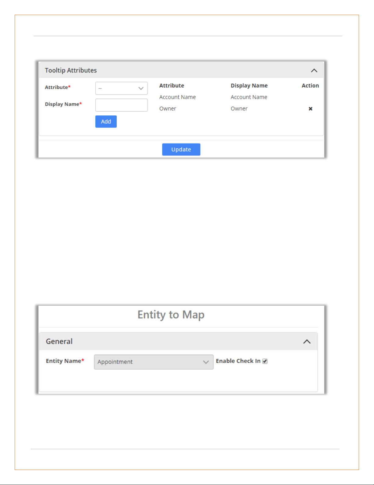
Tooltip Attributes Configuration
• You can make configurations related to what you want to display on ‘tool tip’ when anyone hovers
on that record.
• For that, you can choose the attributes that you want from the dropdown list. You may also define
display name of that attribute. By default, it is same as attribute name. All the selected attributes
are shown in the list from where it can be removed as well.
• After making all the configurations, click on Update button to complete the process.
Enable Check-In
• You will get Check-In & Check Out options for all activity entities along with Add Notes and
Attachment options.
• To enable the Check In option for the activities like etc., tick the Enable Check In option.
• By checking it, you will get the Check-In & Check-Out features for your activity.
USER MANUAL: DynamicsCRM Mappyfield
BIZ/UMP/G1 Public 27
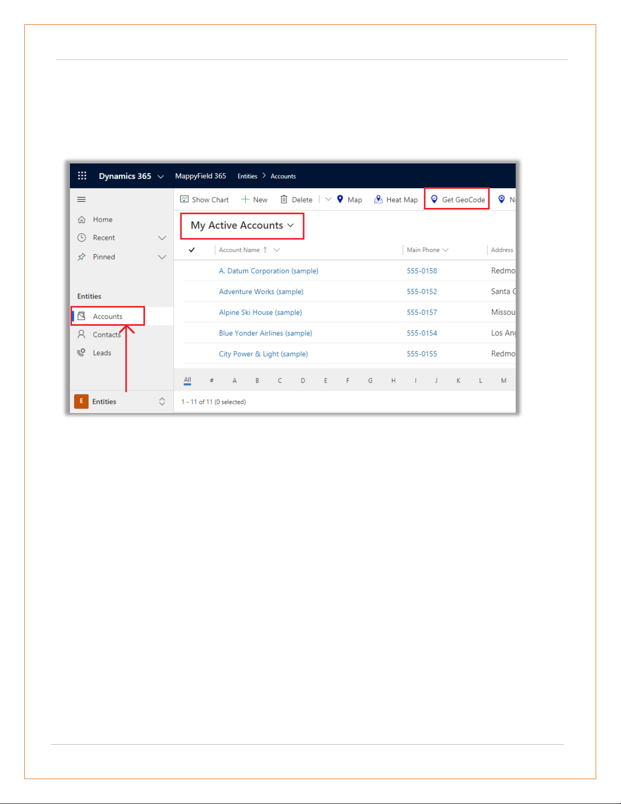
Geocode Records
Manually Geocode the Record
• Navigate to the record for which you want to manually set a geocode: Latitude & Longitude.
• You will get the Geocode as per your selection of view. Here you get the Geocode for “My Active
Accounts”. If you have not selected any record, it will get Geocode for all the Records.
Ex. If you want to geocode any record of account, go to Sales -> Accounts and select a record.
USER MANUAL: DynamicsCRM Mappyfield
BIZ/UMP/G1 Public 28
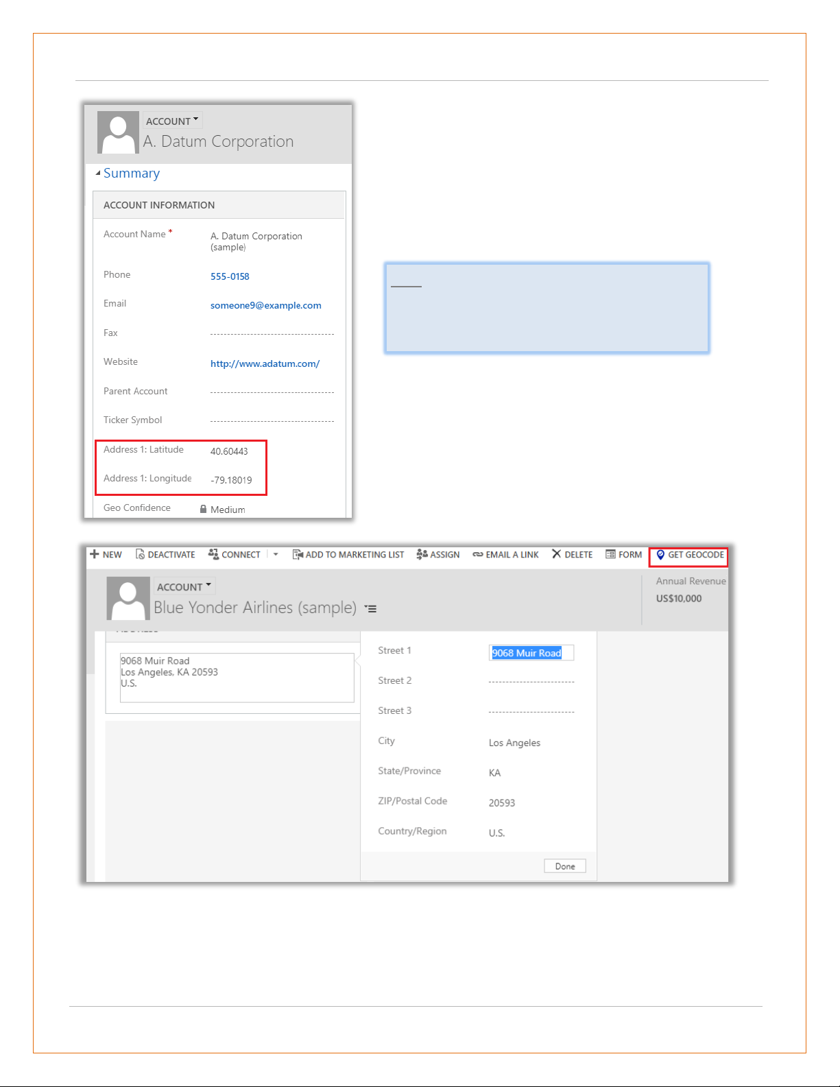
• If you changed the address, then you need to manually geocode that record by clicking on the “Get
Geocode” button from the menu.
• After selecting a record and clicking on Get Geocode,
the “Latitude” & “Longitude” will get updated as per
the address details.
• If you check, the account details, the Geocode:
Latitude & Longitude is updated as shown in the
screenshot.
Note: You get option to geocode records only
when that particular entity is mapped from Entity
Mappings configuration.
USER MANUAL: DynamicsCRM Mappyfield
BIZ/UMP/G1 Public 29
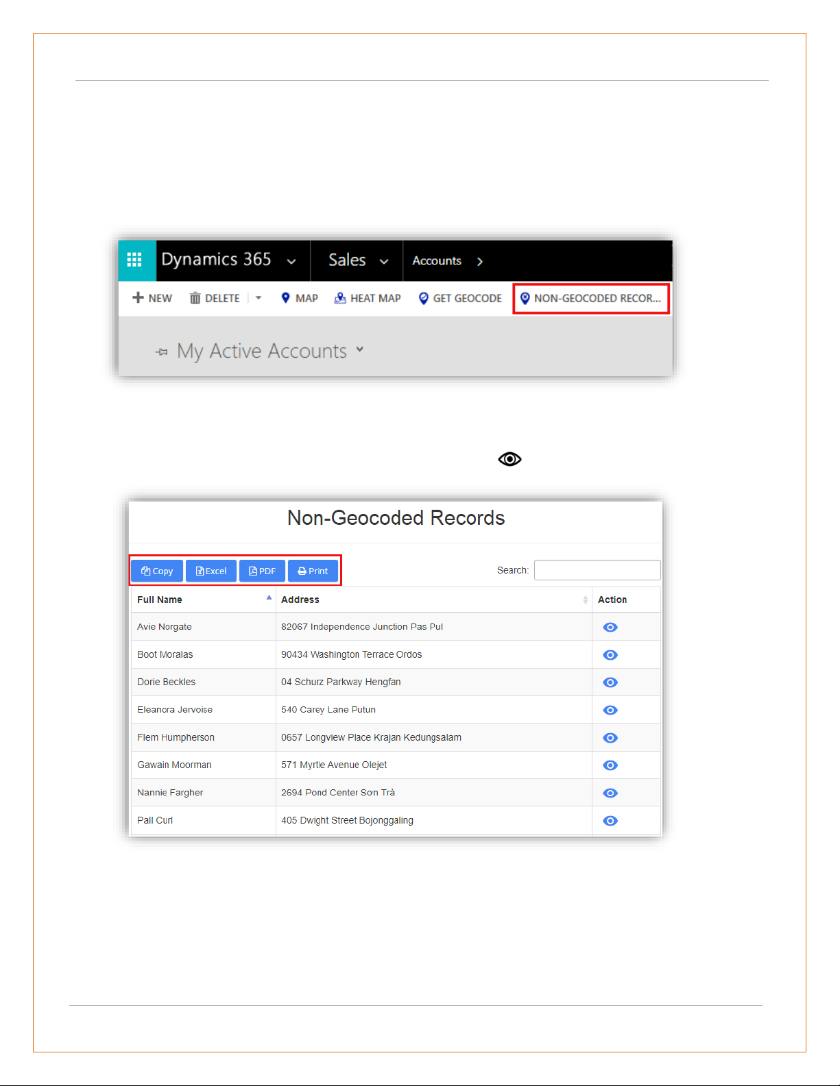
Non-Geocoded Records
• Navigate to the entity for which you want to get a non-geocode detail.
• For example, if you want to check the Non-Geo Coded records from the multiple records of an
account entity, go to Sales -> Account.
• Click on Non-Geocoded Record button, it would show listing of all the non-geocoded records along
with their address.
• You can also view details of the record by clicking on view icon under action column.
• For the list generated, you can also perform actions like Copy, Excel, Pdf, Print and Search as well.
USER MANUAL: DynamicsCRM Mappyfield
BIZ/UMP/G1 Public 30
Individual Records on Map View
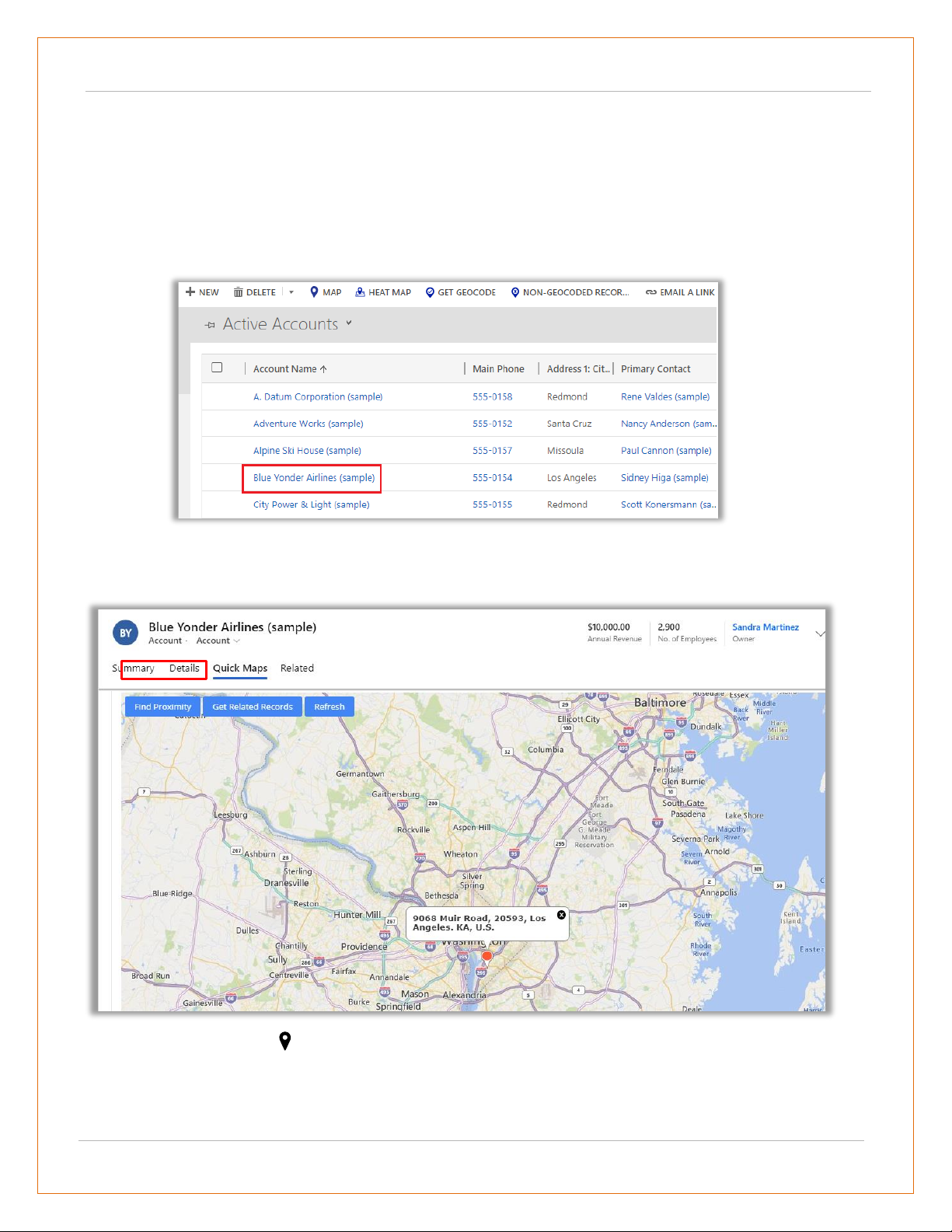
MappyField section in Record Details
• MappyField is separately provided in the Details page of any record of all the mapped entities.
• Click on any record of account entity.
• By clicking on the account name, you will get the summary and the details of that account and by
scrolling down, you will get the separate ‘MappyField’ section.
• On map there is a pin plotted based on the address entered for the record.
• To update the latitude and longitude of the record, you need to move the pin to the desired
location. On moving, it would prompt a confirmation message. Click OK to update and continue.

USER MANUAL: DynamicsCRM Mappyfield
BIZ/UMP/G1 Public 31
• You can update latitude and longitude using record map for records of Account, Contact and Lead
Entities.
• Along with that there are three action buttons: Proximity, Get Related Records and Refresh.
• Find Proximity: Clicking on it, you can perform proximity search from that pin and find records
nearby. It would show records based on entity selected from the dropdown.
• Get Related Records: This action button would fetch all related records to the plotted pin based on
relationship set from the configurations section.
• Refresh: This button would just refresh the map to default map type removing any action performed
on map.

USER MANUAL: DynamicsCRM Mappyfield
BIZ/UMP/G1 Public 32
View Map from Entity Menu
• The map options are provided in all the entities on the header.
• You can access the Map and Heat Map from the Entity.
• By clicking on ‘Map’ or ‘Heat Map’, you will be redirected to the details of the Maps for that
particular entity.

USER MANUAL: DynamicsCRM Mappyfield
BIZ/UMP/G1 Public 33
Map View
• Navigate to Maps. You can perform all the activities and search options from the Map view of
MappyField.
• By clicking on Map, Map page will open with all default configurations and fill up with all the entities
which are already configured in Entity To Map.

USER MANUAL: DynamicsCRM Mappyfield
BIZ/UMP/G1 Public 34
• Select icon on the left to navigate to the map configurations page.
• You will have four Tabs to view the records by selecting the fields and options on MappyField.
▪ Plot
▪ Directions
▪ Templates
▪ Locations
• Along with these options, at the right-hand corner of the map, you will see two options:
Search and Refresh .
• By clicking on the Search icon, you can search the details.
• By clicking on the Refresh icon, you can refresh the details of the page.

USER MANUAL: DynamicsCRM Mappyfield
BIZ/UMP/G1 Public 35
Default Location
• You will get the default location with the pin on the map as per the set up in Quick Map Configuration
by User or as per the current location.
• You can set the default location from the Map by right-clicking on your location. As you right-click, the
menu with options will appear.
• Click on Save Settings -> Default Location. On clicking, the default location will be saved and as you
refresh the page or when you open the map again, you will get the address of default location and see
the pin on the map of default location.

USER MANUAL: DynamicsCRM Mappyfield
BIZ/UMP/G1 Public 36
Plot the records on Map
Select Entity
• First, select Entity from the dropdown option. You will get the dropdown list of entities as per mapped
in Entity Mappings configuration. (left image)
• After selection of Entity and its View, click on Search button to plot and view the records on map.
(right image)
• Now, you can see all the Accounts are plotted on the Map.

USER MANUAL: DynamicsCRM Mappyfield
BIZ/UMP/G1 Public 37
• The multiple Entities selection option is also given to plot and view the multiple records on the map.
• To select another Entity, click on + Add Legend text caption. As you click on it, the “Select Entity”
option will be added.
• Now, select another Entity and select its View then click on Search button.
• You can add maximum 5 Entities.

USER MANUAL: DynamicsCRM Mappyfield
BIZ/UMP/G1 Public 38
• On selection of more than one entity, pins with different colors get plotted based on the
records of entities. On map, Accounts are plotted in red pin and Leads are plotted in green pin .
• If entities like Account, Contact or Lead are mapped, only then the records of activity entities will
be plotted on the map.
Pin selection for records
• Every time when you add a new entity the pin will be added with different color.
• Multiple pin options are also available to differentiate multiple entity (legend) records, options
will be listed by clicking on existing pin.
• You can change the pin color and its
shape by clicking on the pin of any
entity.

USER MANUAL: DynamicsCRM Mappyfield
BIZ/UMP/G1 Public 39
Cluster Map Records
• For all the pins added on the map, there is an option available to cluster them.
• By ticking the Cluster option, the pins will get clustered based on the proximity. It will make a group
of nearby pins indicating the number of markers.
• Select different pins for the multiple
entities to differentiate the records on
the map.

USER MANUAL: DynamicsCRM Mappyfield
BIZ/UMP/G1 Public 40
Note:
• On zooming in to the map, number of pins in the cluster decreases and you get to see individual
markers on map. (left image)
• Whereas, when zoomed out, it consolidates the markers into clusters again. (right side image)
• On clicking any cluster (no. of groups), it will show all the pins
in spider cluster form .

USER MANUAL: DynamicsCRM Mappyfield
BIZ/UMP/G1 Public 41
Advance Options
• Below the “Select Entity” option, there are four options are given related to records on the map.
Marketing List
• Marketing list contain the members like Account, Contact or Lead records. You can add the
MappyField data in any marketing list to market the specific segments more effectively.
• You can get the “Marketing List” by clicking on Search icon if it has already been created in
Marketing -> Marketing List or you can Add to a new list.
• Marketing List
• Point of Interest
• Select Category (Category Search)
• Summary Card
• By clicking on ‘Marketing List’ icon
under the “Select Entity” option, you
will get the Add to Marketing List
popup window.

USER MANUAL: DynamicsCRM Mappyfield
BIZ/UMP/G1 Public 42
Point of Interest (POI)
• By clicking on the ‘POI’ icon you will get the Point of Interest popup window. (left screenshot)
• Insert the Location. As you insert it, the autofill dropdown will appear. (right screenshot)
• After inserting the POI Location, click on location type. Suppose, by clicking on restaurant icon,
the restaurant record will be plotted on the map based on the POI Location.
• From the left side panel, you will get the list under the Point of Interest with the details.
• If you want to search specific locations
like restaurant, coffee shops, hotels,
airport, gas station, etc. near the plotted
records, click on POI icon.

USER MANUAL: DynamicsCRM Mappyfield
BIZ/UMP/G1 Public 43
Category Search
• You can perform Category Search on single as well as multiple entities.
• Performing this search will list out all attributes of the selected entity. These attributes visible in
the category listing dropdown can be managed under the Entity Configurations section.
• Next, the user needs to select attribute based on which record should be plotted. Here, it would
show dialog box for attribute selection for each entity. You can select one or many.
• Clicking on ‘Search’ button, the data will plot pins as per selection of attributes.

USER MANUAL: DynamicsCRM Mappyfield
BIZ/UMP/G1 Public 44
The ‘Category’ section will be enabled which can be used to view category legend and from there
select/unselect records based on requirement.
Summary Card

USER MANUAL: DynamicsCRM Mappyfield
BIZ/UMP/G1 Public 45
• Clicking on ‘Open Summary Card’ button, you can view total number of records and other entity
related details plotted on map as configured from the back end.
Search Options
• You can plot the records of particular
entity based on different Search Options.
• You can plot the records based on five
Search Options: Region, Drawing,
Territory, Proximity and by User.

USER MANUAL: DynamicsCRM Mappyfield
BIZ/UMP/G1 Public 46
By Region
▪ User can also plot multiple regions in map by adding comma (,) separated values. For example Texas,
Tennessee.
▪ Here by selecting ‘State’ under the Region, only the inserted states get highlighted on map along with
plotted pins that come under that states.
▪ By region option lets you plot records on the map
based on the region of your choice.
▪ The various regions that you can select one from
are City, State, Country, and Postal Code.
▪ By clicking on any shape, it will display
summary card for selected shape and
data will be updated in DataGrid
accordingly.

USER MANUAL: DynamicsCRM Mappyfield
BIZ/UMP/G1 Public 47
By Drawing
▪ You can plot the data by defining your own shapes. By selecting the Drawing search option,
the drawing tool will enable you to draw the following shapes: Polygon, Circle and Square.
▪ You can edit the drawn shape by selecting ‘Edit’ icon. After selecting Edit icon, you can
move the shape and increase/decrease the area of the shape.
▪ You can remove the drawn shape by selecting ‘’Erase” icon and then click on the shape.
▪ You can change the fill color and the
outline color of the shape.
▪ The color picker option is given to
change the color of both.

USER MANUAL: DynamicsCRM Mappyfield
BIZ/UMP/G1 Public 48
By Territory
▪ You can also view records on maps based on Territory. By selecting the ‘Territory’ in search
option , you will get the list of Territories in dropdown.
Note: In order to select territory, territories should be defined by you along with their territory manager
in CRM.
To manage territories, follow these steps: Settings > Business Management > Sales Territories.
Also, territories reflect based on territories created under territory management section.
▪ Select the Territory/Territories the
records of which you want to display on
the map.
▪ Now, on clicking Search button, all
records that fall under the selected
territory will be plotted on map.
▪ Note: This dropdown would show those
territories also that are created from
created under Territory Management
section or from Settings -> Sales Territory

USER MANUAL: DynamicsCRM Mappyfield
BIZ/UMP/G1 Public 49
By Proximity
▪ It lets you view nearby records in proximity from current location based on Distance or Time.
▪ You can define distance either in miles or kilometers as well as time in minutes.
By User
▪ You can plot records based on user. It would
plot all records created by the selected user.
▪ By clicking on Search button, the records of
the selected user will be plotted on the map.
Note: This search option is available only to users
with admin role.

USER MANUAL: DynamicsCRM Mappyfield
BIZ/UMP/G1 Public 50
Layer Menu
• With every plotting records on the map, it would show each plotting as Layer.
• Layer Menu displays all plotted Record types in one place. From here, you can hide/show the
records on the map and visible/invisible the ‘labels’ of the push pins.
• As shown in screenshots below, you can see the layers as per the plotted data: POI Layer,
Accounts, Leads and the Territory Layer.
• By clicking on Invisible icon (eye icon), you can view labels for the pushpins.
• User can select just the required data among the
plotted data on the map from the Layer Menu.
• To show or hide the layers of different plotted data
to view on the map, User can use ‘toggle’ buttons.

USER MANUAL: DynamicsCRM Mappyfield
BIZ/UMP/G1 Public 51
• You can see the label (name) of all the accounts.
• Suppose by clicking on (eye icon) of
Accounts – Active Accounts, the label (name) of
the accounts will be visible on the map.

USER MANUAL: DynamicsCRM Mappyfield
BIZ/UMP/G1 Public 52
Save Template
• All the plotting data made along with zoom level configurations can be saved as Template.
• By clicking on Save Template button, a dialog box opens to give a name to the template.
Moreover, you can ‘tick’ the box Is Public to make the template public.
• After inserting the Template name, click on Save button to save the template for future reference.

USER MANUAL: DynamicsCRM Mappyfield
BIZ/UMP/G1 Public 53
Map View options
• There are many options and actions provided to manage the map records easily from the Map View.
Details on Hover
• You can view record name by
hovering on any pushpin.
Information shown on hover is
completely customizable from
the Entity Mapping.

USER MANUAL: DynamicsCRM Mappyfield
BIZ/UMP/G1 Public 54
Tooltip Details
• By clicking on any particular pin, you will get details related to that record based on configurations
done from the backend.
• Along with details there are actions buttons
available in the pop-up.
• These action buttons will let you perform
different actions related to Directions like:
> Add to Origin > Add to Destination

USER MANUAL: DynamicsCRM Mappyfield
BIZ/UMP/G1 Public 55
Note: These action buttons are present by default on record of every entity and these buttons cannot be
changed.
Note: Other than these, there are few actions buttons like Add Task and Add Appointment that are
dependent on the selected entity.
• While related to Share & Assign like:
> Send Email
> Assign Owner
> Add to Marketing List
• There are some other actions that
can be enabled/disabled from the
Security Template configuration.
• Other Actions:
> Proximity Search
> Related Records
> Point of Interest
> Delete Record
> Add Task
> Add Appointment

USER MANUAL: DynamicsCRM Mappyfield
BIZ/UMP/G1 Public 56
Add to Origin
• From Directions tab you can get route from any location to your customer’s location.
• On the map, the ‘Starting Point’ will be assigned as A with the address of that record displayed.
• By clicking on Add to Origin option, address
of that record will be added as starting point
of route under Directions tab.

USER MANUAL: DynamicsCRM Mappyfield
BIZ/UMP/G1 Public 57
Add to Destination
• By clicking on the Add to Destination option, the address of that record will be added as destination
point of route under Directions tab.
• You can select the Origin and the Destination between the plotted records from the Directions option
and manage your route based on that direction.
• Click on the GO button to check the routes between selected Origin and Destination on the Map.

USER MANUAL: DynamicsCRM Mappyfield
BIZ/UMP/G1 Public 58
Send Email using Template
▪ To send email, click on “Send Email” action button. Clicking on that action button, it would
prompt user to select an email template.
▪ The email templates list would have list of all the templates that are created within the CRM
and custom templates as well. You may select from the list or select New email to create a
new one. Selecting template would directly perform the mail action if email id is available.
While creating a new one would redirect to CRM email screen.
Note: If user to whom the mail is being sent isn’t operating the email address, then the mail won’t be sent
and an error message stating that record’s email address is not active will be displayed.
Assign Owner
▪ You can assign any record to specific user or team by clicking on “Assign Owner” option from
specific user’s details.
▪ Selecting Assign Owner option, it opens a dialog box where dropdown list of all the CRM users
is provided to select user or team as required. After selecting the appropriate User/Team,
click on Assign button.

USER MANUAL: DynamicsCRM Mappyfield
BIZ/UMP/G1 Public 59
Note: When assigning record to a user or team, that particular user or team should have role assigned to
it or else record won’t be assigned.
Assign to Marketing List
▪ You can assign any account, contact or lead record to marketing list by clicking on “Assign to
Marketing list” icon under map section or by clicking on “Assign to Marketing list” option from
specific user’s details.
▪ On clicking, you will have the option to add record either in existing marketing list or create
the new one.
▪ After selecting the marketing list, click on the Add button to complete the addition of records
to the marketing list.

USER MANUAL: DynamicsCRM Mappyfield
BIZ/UMP/G1 Public 60
Note: Assign to marketing list icon under map section, will assign all records of particular entity to the list.
Also, it will get assigned only when records of single entity are plotted on map.
Proximity Search
▪ You can define distance either in miles or kilometers as well as time in minutes.
▪ You can also perform concentric proximity search based on distance with three different
values.
▪ Here on defining search criteria of 10,20,30 Km, it will plot records situated in 10,20,30 Km
area from current pin location. Also, you can search in proximity from single entry as well.
▪ It lets you to view nearby records in proximity from
current record based on time or distance.

USER MANUAL: DynamicsCRM Mappyfield
BIZ/UMP/G1 Public 61
▪ On hovering over pin, you get details as configured along with travel distance in case of search
based on distance. And travel time in case of search based on time.
Note: When proximity search is to be done on basis of time, at max you can define 85 minutes.

USER MANUAL: DynamicsCRM Mappyfield
BIZ/UMP/G1 Public 62
Add Task
▪ Any task can be added for a record along with their priority such as Low, Normal, and High.
▪ The task that is added can be viewed in detailed view of record in Dynamics CRM.
▪ You can add task for a record directly from map itself
by clicking on “Add task” icon associated with
particular record.

USER MANUAL: DynamicsCRM Mappyfield
BIZ/UMP/G1 Public 63
Add Appointment
▪ Appointment can be added for a record along with their priority such as Low, Normal, and High.
▪ Along with priority, you can also enter the location of meeting.
▪ The appointment that is added can be viewed in detailed view of record in Dynamics CRM.
▪ You can schedule an appointment for a record
by clicking on “Add appointment” icon
associated with particular record.

USER MANUAL: DynamicsCRM Mappyfield
BIZ/UMP/G1 Public 64
Point of Interest
▪ Clicking on POI under maps tab will let you search for locations from any location that you enter.
▪ When you click on ‘Point of Interest’ section on the left, will show all the plotted point of
interest locations.
▪ You can search for nearby attractions, hotels,
airports, restaurants, coffee shops, gas stations,
etc. by clicking on POI icon.
▪ Clicking on POI icon from particular pin, will take
address of that particular record as POI location
to search nearby places.

USER MANUAL: DynamicsCRM Mappyfield
BIZ/UMP/G1 Public 65
Related Records
▪ By clicking on “Related Records” icon, all related records to the plotted record get plotted on
map.
▪ Here, as there were three contacts associated with the account, all three of them will get
plotted on the map.

USER MANUAL: DynamicsCRM Mappyfield
BIZ/UMP/G1 Public 66
Delete Record
▪ By clicking on delete button, selected record from map gets deleted from the CRM.
Activate Records
▪ By clicking on ‘Activate Records’ icon, status of the particular record gets updated to activated
state. It will be available for records of only Account or Contact entity.
Note: Inactive records will show activate button. Once activated, they will be shown in active view.

USER MANUAL: DynamicsCRM Mappyfield
BIZ/UMP/G1 Public 67
Deactivate Records:
▪ By clicking on “Deactivate Records” icon, status of the particular record gets updated to
deactivate state. It is available for records of only account or contact entity.
▪ On clicking deactivate icon, you will get warning message regrading deactivation. Click Ok to
continue.
Note: Active records will show deactivate button and on deactivating record, deactivated records will be
shown in inactive view.
Qualify Lead
▪ By clicking on “Qualify Lead” icon, status of lead will get updated to close state and user will
be redirected to opportunity page from the map. It is available only for record of lead entity.
Note: Open leads will display option to
qualify/disqualify lead. Once leads are qualified,
those leads will be shown in Closed Leads view.

USER MANUAL: DynamicsCRM Mappyfield
BIZ/UMP/G1 Public 68
Disqualify Lead
▪ By clicking on “Disqualify Lead” icon, leads will get disqualified and its status will be changed
to close.
▪ Also, upon disqualifying lead, user needs to select the reason for disqualifying lead. Reasons
can be like Lost, Cannot Contact, No Longer Interested and Cancelled. It is available only for
lead entity. After you select reason click on Disqualify button to complete the action.
▪ Disqualified leads can be reactivated by clicking on Reactivate Icon present with closed lead
record.

USER MANUAL: DynamicsCRM Mappyfield
BIZ/UMP/G1 Public 69
Reactivate Lead
▪ By clicking on “Reactivate Lead” icon, leads will be reactivated, and its status will be changed
to Open.
Note: On reactivating lead, view of lead will get updated from closed leads to open leads.

USER MANUAL: DynamicsCRM Mappyfield
BIZ/UMP/G1 Public 70
Direction
• In the Directions tab, you will get the route navigation with details. On the Map, you will get
directions based on Driving including alternate direction if any.
• In Direction tab, you can also add multiple address and get directions. You can reverse the direction
by clicking on this icon .
• You can add multiple way points by clicking on ‘Add Destination’. You can add a maximum of 25-
way points.

USER MANUAL: DynamicsCRM Mappyfield
BIZ/UMP/G1 Public 71
Multiple Routes
• By clicking on any location or plotted records, click on ‘Add to Destination’ to add multiple way
points. As you add all the required location and click on GO button, you will get the routes based on
the location of multiple way points
• For all the waypoints added in the route, each way
point can be dragged to reorder their position in
the route.
• After reordering the route, it will immediately
reflect on the map also.

USER MANUAL: DynamicsCRM Mappyfield
BIZ/UMP/G1 Public 72
• You can select the time at which the
generated route is going to be used by you.
• For that click on Leave now option.
• Arrive by option is only available when there
are only Origin and Destination locations set.
• By clicking on Leave Now, you will get
Leave now, Leave at and Arrive by options.
• Select the date and time when you want to
travel.

USER MANUAL: DynamicsCRM Mappyfield
BIZ/UMP/G1 Public 73
• After selecting the location between Origin and Destination, it will list all possible routes and
highlight the optimized route.
• You can also get directions based on means of transport like Public Transit and Walking.

USER MANUAL: DynamicsCRM Mappyfield
BIZ/UMP/G1 Public 74
Email Route
Save Route
• You can share a route in mail by clicking on Email icon.
• As you click on it, the Email page will
open with the link of selected route.
• Also, the selected route can be saved for
future reference.
• To save a route, click on the Save icon
available on the top.
• By clicking on Save icon, it opens a dialog
box where you need to provide a name to
the route and user/team name to whom
the route is being assigned.
• Along with this, you can also define route
date and priority. Priority can be set from
Low, Normal and High.

USER MANUAL: DynamicsCRM Mappyfield
BIZ/UMP/G1 Public 75
• You can also apply various filters on route by clicking on “Options” dropdown. Various filters related
to Distance are:
• Selecting along the route search option prompts user to enter search radius and its unit.
• By default, it can be managed from the configurations. This would search records within the given
radius of plotted route and displays pin in different colors than that which are within the route.
• Under “Direction” section, you can view all
Saved Routes.
• You can preview the routes and delete any if it is
not required.
• Routes can also be filtered based on Start date
and End date.
- Miles/KM
- Directions: Shortest Time/ Distance
- Avoid Highways
- Avoid Tolls
- Avoid Ferries
- Along the Route Search

USER MANUAL: DynamicsCRM Mappyfield
BIZ/UMP/G1 Public 76
SPF (Shortest Path First)
• If Route optimization is enabled from Configuration, then it will short the added routes with SPF
algorithm. It can rearrange route according to their distance from each other.
Before SPF
After SPF
Note: If you have enabled
the SPF from the Default
Configuration, only then
SPF algorithm gets
applied on the route.

USER MANUAL: DynamicsCRM Mappyfield
BIZ/UMP/G1 Public 77
Templates
• Templates feature helps you save map configurations so that you can come back to them later and
tweak them according to requirement.
• Under Templates section, logged in users can see all the templates created by them or the
templates that are made public.
• The templates can be previewed by clicking on View icon or You can delete as per your
requirement.
• If you’ve selected Is Public for the Template at the
time of saving, it will be visible to all CRM users of
AppJetty Mappyfield.
Note: If template is not public, only admin and the user
who created that template will be able to view it.

USER MANUAL: DynamicsCRM Mappyfield
BIZ/UMP/G1 Public 78

USER MANUAL: DynamicsCRM Mappyfield
BIZ/UMP/G1 Public 79
Locations
Add New Location
• From the “Locations” tab, the user can save the current location by clicking on the Add Locations
button. So that later they can come back when required.
• By clicking on the Add Location button, Add New Location popup will appear.
• The Zoom level will be selected as per the Map view and enter Location Name. Click on “Save”
button to add location.
• Later, the user can also View, Edit or Delete
location from action tab in location listing.

USER MANUAL: DynamicsCRM Mappyfield
BIZ/UMP/G1 Public 80
Track User
• You can get the details of Last updated location and time by clicking on Pin.
Note: Following conditions needs to be fulfilled in order to track user’s location
• Enable user tracking must be enabled from default configuration.
• User must have MappyField role or able to access MappyField and must be logged in to
MappyField.
• User must allow location access from mobile or web through which user is using MappyField.
• MappyField must be open in order to track user’s location.
• In Every 5 Mins, Users’ location will be updated.
• You can track all CRM users which are logged in
on Mappyfield.
• Select the users to track them.
• By selecting the Users and click on Search button,
User tracking details can be seen on the map.
Note: Track User Option only visible to admin user.

USER MANUAL: DynamicsCRM Mappyfield
BIZ/UMP/G1 Public 81
Data Grid
• Data Grid provides listing of records which are plotted on the map.
• To view data grid, click on Show Data.
• By clicking on Show Data, a slider will open. You can view the plotted data as per selection of Entity.

USER MANUAL: DynamicsCRM Mappyfield
BIZ/UMP/G1 Public 82
• You can perform different actions by selecting the data grid records:
> Add Record To Route > Change owner > Add Task > Add Appointment
> Send Email > Manage Territory > Schedule Records
• Data in Data Grid is displayed according to entity selected in the dropdown. Based on selected
entity, data will be updated in grid. In the dropdown list, you will get only those entities which are
selected to plot the record on map.
• Copy: By clicking on the Copy button, all or selected records are copied onto the clipboard to be
pasted anywhere you want.
• Excel: Clicking on Excel button downloads all or selected records available in data grid in xlsx file
format.
• PDF: By clicking on PDF button, all or selected records present in grid are downloaded in PDF file
format.
• Print: Print button helps you to take print of selected or all records present in data grid.
• By clicking on View icon , that record will get opened in CRM. By clicking on Delete icon , it
deletes the respective record from the CRM.

USER MANUAL: DynamicsCRM Mappyfield
BIZ/UMP/G1 Public 83
• You can perform actions by selecting records within the data grid as shown below:
Add Record to Route
• Select the records and click on the “Add Record to Route” icon to add the records to the route.
Note: If you proceed to perform any action from data grid without selecting any record, you will get the
Alert message that will prompt you to select the record.
• By clicking on that icon, the Menu tab on
the left appear opening the Direction Tab.
• The locations will be added based on the
record selection in Data Grid.

USER MANUAL: DynamicsCRM Mappyfield
BIZ/UMP/G1 Public 84
Assign to User/Team:
Add Task:
• Similarly, you can add the Appointment of selected records by clicking on Add Appointment icon.
• You can add the Task of selected records
by clicking on Add Task icon.
• As you click on that icon, the Add Task
popup window will open to insert the
Task related details.
• After clicking on Create button, Task will
be added.
• You can directly assign the selected
record to the User / Team.
• As you click on that icon, the Assign
to User or Team popup window will
open to select the User/Team.
• After selecting User/Teams, click on
Assign button.

USER MANUAL: DynamicsCRM Mappyfield
BIZ/UMP/G1 Public 85
Send Email using Template
Manage Territory
• Send Email by selecting the records.
• As you click on Email icon, the Send
Email popup window will open. You
need to select the Email Template.
• By selecting an email template, you can
send the Email on the email ids of the
selected records.
• By clicking on Send Email button the
email page will be redirected.
• From the Data Grid, you can add your
selected records in the particular
Territory.
• As you click on Territory icon, the
Mange Territory window will open.
• You need to select the Territory and
after that click on Save button.
• Here you will get the dropdown list of
the Territories as per Adding and
Managing Territories.

USER MANUAL: DynamicsCRM Mappyfield
BIZ/UMP/G1 Public 86
Auto Schedule Records
Auto Schedule Records
• You will find the Auto Schedule Records option in Data Grid only. Select the required data from the
Data Grid and click on Auto Schedule icon.
• You will be redirected to Auto Scheduling with its slider in left side. In map configuration Auto scheduling
configuration will be there according to set values. In configuration, data will be filled in Auto scheduling
popup.
• You can auto schedule the selected
records by clicking on this icon.
• As you click on it, the warning
message will appear that just inform
that the plotted records will be
cleared on the map.

USER MANUAL: DynamicsCRM Mappyfield
BIZ/UMP/G1 Public 87
• Time Period: Select Time duration, Total working
days/week/month. (Mandatory field)
• Start Location: Insert your starting location from where
you want to start the schedule. (Mandatory field)
• End Location: Insert your ending location where your
scheduling end.
• Time Period: Select day/days for Auto Schedule.
• Meeting Duration: Select the time for each plotted
record for meeting or appointment.
• Schedule Start Time: Select Starting Time of
the day.
• Schedule End Time: Select Ending Time of
the day.
• Break Start Time: Select Break Start time in
between scheduled time.
• Break end time: Select Break End time in
between scheduled time.
• Extra/Buffer Time : Select time for a day for
extra work.
• Working Days: Select days for working.
You will get the date wise schedule as per
selection of Time Period and you will get the
date wise schedule as per selected days.

USER MANUAL: DynamicsCRM Mappyfield
BIZ/UMP/G1 Public 88
• If your activity is starting from date of 6
th
Feb (Thu.), Time period is 5 days and selected Days are:
Monday, Tuesday, Thursday and Friday. You will get the date as per the selection of the days.
Wednesday will be skipped.
• You can save the schedule by
clicking on Save Schedule.

USER MANUAL: DynamicsCRM Mappyfield
BIZ/UMP/G1 Public 89
• As you click on Save Schedule button, the Save Route popup will appear. Enter ‘Route Name’ and
‘assign’ it to user by selecting user from the dropdown.
• Now you can redirect to main page of map by clicking on ‘left arrow’ icon.
• You will get the Saved Scheduled Routes
under the Direction tab.
• You can view the Routes by clicking on
view icon.
• Here, you will get the direction based on
SPF algorithm.

USER MANUAL: DynamicsCRM Mappyfield
BIZ/UMP/G1 Public 90
Check-Ins/Check-Outs
• You can use check-in and check-out features in the all activity entities.
• Check-In feature enables admin/user to keep track of exact time spent behind an activity.
• With the help of check in/check out button, you can tag geo-coordinates of the location and time
while starting and completing an activity.
▪ To perform check in, click on check in icon available on the info card of an activity.
▪ Once checked in, it would show action button to check out. User can insert the Notes at the
time of Check-Out.
▪ User can Check-In or Check-Out from the map by clicking on the activity or from the detail
view of activities by clicking on the title activity name.

USER MANUAL: DynamicsCRM Mappyfield
BIZ/UMP/G1 Public 91
• To check all the Check-Ins record, navigate to AppJetty tab -> Check Ins. It will list all the check in
records.
• Check-in takes the address of the record regarding an activity and lets you perform check in only
when address is found. The user will only be able to check in if they are in the check in radius as
configured by the admin.
• On map as well, you can plot check in entity and its corresponding view to have idea of all check ins.

USER MANUAL: DynamicsCRM Mappyfield
BIZ/UMP/G1 Public 92
• User can add note and upload the attachment while checking out from the activity.
• You can check the Notes in the Check-Ins module within the Check-Out view from Note section.
• It will list all possible route and highlight the optimized route. Also, you can get directions based on
means of transport like Driving, Walking and Transit. You can also share route in email using link.

USER MANUAL: DynamicsCRM Mappyfield
BIZ/UMP/G1 Public 93
Contextual Menu
• It provides options as below:
> Create New Record > Add to Route > Add to Locations > Set as POI Location
> Set As Current Location.
You (or logged in user) can also set default settings by hovering on ‘Save Settings’ option:
> Default Location > Map zoom level > Origin > Destination.
• These settings directly get saved under MappyField Configuration record for logged in user.
• By selecting Create New Record Option, open a dialog box to select record type.
• It can be Account, Contact or Lead. Upon selection of the option, you are redirected to a particular
entity page of record creation.
• Similarly, you can perform map view and map records related other actions directly from here.
• ‘Right click’ on to map to open
Contextual Menu.

USER MANUAL: DynamicsCRM Mappyfield
BIZ/UMP/G1 Public 94
Territory Management
• Using territory management, you can create new territories or manage existing territories directly
from the map itself.
• You can plot regions on map based on files, by location of regions, and by drawing. Based on plotted
regions, you can use the Alignment tool to select the required regions and create new territories.
Also, you can plot the existing territories and copy or move them as required.
• To perform territory management, click on the Territory Management.
• Different search options available are By Region, By Drawing, By Territory, By File.

USER MANUAL: DynamicsCRM Mappyfield
BIZ/UMP/G1 Public 95
• By Region: This option helps users to search for regions on the map i.e. City, State, Country and
Postal Code.
• By Drawing: This lets you draw a shape using custom drawing tool:
Union, Union Aggregate, Difference, Intersection, Disjunctive Union. You can perform the actions
like: Undo, Reset and After performing shape operation user can create new territory of that
resulted shape.
• By Territory: Using this option, you can plot existing territories on the map.
• By File: This option helps in plotting shape files. Supported file types are .shp, .kml, and .geojson.
• After plotting, using territory alignment tool, you can select/deselect territories as required on the
map. Using alignment tool, you can select/deselect, remove selection or refresh and download map.
• Create New Territory: Select region/shape and right clicking on selected region, it would show
option to create new territory.

USER MANUAL: DynamicsCRM Mappyfield
BIZ/UMP/G1 Public 96
• Clicking on Create New Territory would open a dialog box to enter territory name and select
manager for a territory. User can also choose to add the new territory within existing territory by
selecting Add to existing territory option.
• Copy/Move Territory: Right clicking on selected region/shape that is an existing territory, it would
show option to copy or move territory.

USER MANUAL: DynamicsCRM Mappyfield
BIZ/UMP/G1 Public 97
• Clicking on Copy to/Move to would open a dialog box to select if territory has to be copied/moved
to an existing territory or create a new one. In case of new one, it would ask to enter territory name
followed with manager selection for the territory.
• Shape Operations: For drawing shapes plotted on map, user can select shapes that are drawn using
drawing tool and right click on them to select binary operations. Five different shape operations
available are: Difference, Intersection, Union, Union Aggregate and Disjunctive Union.
Note:
1. Shapes should overlap each other for performing shape operations. In order to perform binary
operation, shapes should be selected.
2. Move To/Copy To works on shapes of plotted territories.

USER MANUAL: DynamicsCRM Mappyfield
BIZ/UMP/G1 Public 98
Heat Map
• Navigate to AppJetty -> Heat Map.
• By clicking on Heat Map, Heat Map page will be open with all default configurations and fill up with
all the entities which are already configured in “Entity To Map”.
• It would open a map for you to select further map options. Here, it would list all those entities that
are configured under Entity Mappings.
• Different options are:
▪ Select Data source: Choose entity and its view to analyze data.
▪ Select Measure: Select the aggregation method to be used to color code the region. By
default, it would be based on number of records.
▪ Select Filter: This option lets you select category to filter data results.
▪ Select Display: You get four different options to analyze data on heat map. Options are:
▪ Boundary: This creates heat map based on selected region type.

USER MANUAL: DynamicsCRM Mappyfield
BIZ/UMP/G1 Public 99
▪ No Boundary: This option creates heat map based on density of the measure
selected without geographical boundaries.
▪ Pie Chart: View data in form of pie charts based on attributes selected in measure & filter.

USER MANUAL: DynamicsCRM Mappyfield
BIZ/UMP/G1 Public 100
▪ Column Chart: View data in form of column charts based on attributes selected in
measure and filter.
• Select Region Type: Define geography level of aggregation. It can be any from the city, state,
country and postal code.
Note: On hover, it shows details of the boundary, pie chart or column chart attributes and clicking on
particular highlighted region shows up the summarized information for the same.
 Loading...