

Page 1

DESTINATOR PN
USER GUIDE
Page 2

Destinator PN User Guide
Notices, Disclaimers and Terms of Use
1. Limited Product Warranty. Homeland Security Technology Corporation (HSTC), warrants to the
Client that the Products shall substantially conform to HSTC’s specification for a period of one (1)
year from the date of the original purchase by the end user (the "Warranty Period"). As HSTC 's
sole obligation and Client's exclusive remedy for any breach of warranty, HSTC agrees, at its sole
option, to (i) use reasonable efforts to repair the Product with new or refurbished replacement parts;
(ii) replace the Product with a new or refurbished unit; or (iii) refund the purchase price, provided
Client returns the defective Products to HSTC with proof of purchase and HSTC’s authorization.
HSTC’s warranty hereunder does not apply in case of any damage caused by accident, abuse,
misuse, misapplication, or alteration of any kind performed by anyone other than HSTC. The
Products are not designed or licensed for use in mission-critical applications, or in hazardous
environments, requiring fail-safe controls, including without limitation operation of nuclear facilities,
aircraft navigation or communication systems, air traffic control, or life support or weapons systems.
Without limiting the generality of the foregoing, HSTC specifically disclaims any express or implied
warranty or condition of fitness for such purposes. HSTC’s warranty does not, in any event, apply to
physical damage to the surface of the Product or replacement. HSTC shall have no obligation with
respect to any data stored in the Product.
Except as expressly stated in this section, HSTC makes no warranties or includes any conditions
with respect to the products, express or implied, including, but not limited to, the implied warranties
or conditions of merchantability, fitness for a particular purpose and no infringement.
2. Liability Limitation. In no event shall HSTC, be liable to Client, (and Client hereby waives any
indirect, special, incidental, or consequential damages in connection with) the transactions
contemplated by this agreement, whether or not such damages were foreseen, or their likelihood
disclosed. HSTC shall not be liable to Client or any third party claiming through Client, for any
damages of any kind in excess of the amounts paid by Client under the terms of this agreement with
respect to the products giving rise to such damages. Some jurisdictions do not allow the exclusion
of or limitation on implied conditions, warranties or damages, thus some of the foregoing may not
apply to Client.
3. Intellectual Property Rights. Hardware and Software are proprietary to HSTC or its suppliers
and are subject to copyright and other intellectual property laws. Client's only rights with respect to
any HSTC software included with the Products shall be provided, under the terms of HSTC ’s
software license. Title to all HSTC Software remains with HSTC. Client agrees that HSTC retains
ownership of all rights, title and interest in all intellectual property, works of authorship, trade secrets
and like’s in all aspects of the Product(s). Client and its affiliates and subcontractors agree not to
reverse engineer any aspect of the Software and/or Products supplied under this agreement and
further agree to pay assessed damages should such action take place.
4. Copyright and Copies. The Software (including any copy thereof) is owned by HSTC or its
suppliers and is protected by United States, Canada, European, Brazilian and Australian copyright
and patent laws and international treaty provisions. The Software copy is licensed to you the client,
not sold to you, and you (the client) are not an owner of any copy thereof. You may make one copy
of the software for backup or archival purposes. You may not otherwise copy the software, except
as authorized by applicable law, nor the written materials accompanying the Software. HSTC
hereby reserves all rights not explicitly granted in this license agreement.
Copyright © 2005, HSTC.
April 29, 2005
Page 2 of 118
Page 3

Destinator PN User Guide
Table of Contents
Chapter 1 Welcome To Destinator PN........................................................................... 9
1.1 Introduction ......................................................................................................................9
1.2 Getting Help.....................................................................................................................9
1.3 Technical Support..........................................................................................................10
Chapter 2 Installing Destinator PN .............................................................................. 11
2.1 Introduction ....................................................................................................................11
2.2 Install Destinator Console..............................................................................................11
2.3 Install Destinator PN To Pocket PC............................................................................... 12
Prerequisites ........................................................................................................... 12
Install Destinator ..................................................................................................... 13
Install TTS (Text To Speech) .................................................................................. 15
2.4 Install The Map(s) ..........................................................................................................16
Where to Load map(s) ............................................................................................16
Select Maps to Load ...............................................................................................17
Chapter 3 Activation...................................................................................................... 19
3.1 Introduction ....................................................................................................................19
3.2 Voucher For License Key ..............................................................................................19
3.3 Quick Activation .............................................................................................................19
3.4 SMS Activation ..............................................................................................................22
Chapter 4 Hardware Installation................................................................................... 25
4.1 Introduction ....................................................................................................................25
Warnings ................................................................................................................. 25
4.2 Connecting the Hardware ..............................................................................................26
Chapter 5
5.1 Introduction ....................................................................................................................29
5.2 Menu and Toolbar Overview.......................................................................................... 29
5.3 Removal of Previous Destinator Versions .....................................................................32
5.4 Creating Your Own Maps ..............................................................................................33
5.5 Cutting Maps.................................................................................................................. 35
5.6 Route Cutting.................................................................................................................36
5.7 Selecting Pre-Cut Maps................................................................................................. 37
Using Destinator PN Console..................................................................... 29
Toolbar .................................................................................................................... 29
File Menu ................................................................................................................ 30
Tool Menu ............................................................................................................... 31
Help Menu............................................................................................................... 31
Exit from Destinator Console .................................................................................. 32
Selecting by Address ..............................................................................................37
Selecting Map by Intersection................................................................................. 39
Selecting Map by Points of Interest (POI)............................................................... 40
Page 3 of 118
Page 4

Destinator PN User Guide
Selecting by Sub Region......................................................................................... 41
5.8 Loading Newly Created Maps to Pocket PC.................................................................. 41
5.9 Removing Map(s) from Memory ....................................................................................42
5.10 Activating New Maps ..................................................................................................... 43
5.11 Removing Navigation Software .....................................................................................44
5.12 Exit From Destinator Console........................................................................................45
Chapter 6
6.1 Introduction ....................................................................................................................47
6.2 Map Description.............................................................................................................48
6.3 The Destination Menu.................................................................................................... 51
6.4 Navigate To An Address (or Intersection)...................................................................... 53
6.5 Navigate To A Point of Interest (POI) ............................................................................56
6.6 Navigate To A Favorite ..................................................................................................59
6.7 Save To Favorites.......................................................................................................... 60
6.8 Navigate To A History Item............................................................................................ 61
6.9 Navigate To A Contact................................................................................................... 62
6.10 Navigate To An SMS Inbox Item ...................................................................................64
6.11 Navigate To A Point on the Map....................................................................................65
6.12 Trip Planning..................................................................................................................67
Navigating a Route ...................................................................................... 47
How to Use Trip Planning ....................................................................................... 67
6.13 Avoid Roads ..................................................................................................................71
6.14 TMC ...............................................................................................................................72
Chapter 7 Options.......................................................................................................... 77
7.1 Introduction ....................................................................................................................77
7.2 The Options Menu .........................................................................................................78
7.3 Show Route ...................................................................................................................78
7.4 Driving Directions........................................................................................................... 78
Show Route............................................................................................................. 79
Cancel Route .......................................................................................................... 79
Show Turn............................................................................................................... 79
Avoid Turn............................................................................................................... 80
7.5 Turn By Turn..................................................................................................................80
7.6 Cancel Route .................................................................................................................81
7.7 Play................................................................................................................................81
7.8 Switch Maps ..................................................................................................................81
7.9 Travel Mode................................................................................................................... 81
7.10 Help ............................................................................................................................... 82
7.11 About ............................................................................................................................. 82
Chapter 8 Settings.........................................................................................................83
8.1 Introduction ....................................................................................................................83
8.2 The Settings Menu......................................................................................................... 84
8.3 GPS Status And Settings............................................................................................... 84
8.4 Home Button Settings.................................................................................................... 86
8.5 General Settings ............................................................................................................87
8.6 Map Settings.................................................................................................................. 88
Map Orientation....................................................................................................... 89
Page 4 of 118
Page 5

Destinator PN User Guide
Zoom Mechanism.................................................................................................... 89
Map Font ................................................................................................................. 89
8.7 Route Settings ............................................................................................................... 90
Routing Mode.......................................................................................................... 90
Route generation..................................................................................................... 91
U Turn Usage.......................................................................................................... 91
8.8 Alert Settings .................................................................................................................91
8.9 Visual Notifications ........................................................................................................93
8.10 Look & Feel....................................................................................................................94
Chapter 9 Changing Map Views................................................................................... 95
9.1 Introduction ....................................................................................................................95
9.2 How to Zoom and Scroll ................................................................................................96
9.3 Types of View ................................................................................................................ 97
Chapter 10
10.1 Introduction ..................................................................................................................101
10.2 Configuring Auto Alerts Category ................................................................................ 101
10.3 Configuring Auto Alerts Items ......................................................................................102
10.4 Favorites Alerts............................................................................................................102
Auto & Favorites Alerts............................................................................. 101
Chapter 11 Favorites Importing ................................................................................... 103
11.1 Introduction ..................................................................................................................103
11.2 Downloading Favorites ................................................................................................ 103
Glossary ............................................................................................................................ 105
Appendix A - Favorites Importing File Structure .......................................................... 107
Appendix B - Manual Activation of Destinator PN ........................................................108
Appendix C – Sending a Location as an SMS Message............................................... 111
Index .................................................................................................................................. 115
Note:
The content of this document constantly changes, to reflect the latest changes in
procedures, screens, buttons, icons, general improvements and updates to the
Destinator PN software, hardware and maps.
Page 5 of 118
Page 6

Destinator PN User Guide
Table of Figures
Figure 1 - Installation Language selection Pop-up ........................................................ 11
Figure 2 - Install TMC Dialog......................................................................................... 13
Figure 3 - Install to Default Directory............................................................................. 14
Figure 4 - Status Window for Installation....................................................................... 14
Figure 5 - Refer to Device Screen................................................................................. 14
Figure 6 - Select Language for TTS .............................................................................. 15
Figure 7 - Install TTS to Default Directory ..................................................................... 15
Figure 8 - Status Window for TTS Installation ............................................................... 16
Figure 9 - Change Target Device (Memory).................................................................. 16
Figure 10 - Quick Activation Dialog ............................................................................... 20
Figure 11 - User Information Screen ............................................................................. 21
Figure 12 - License Key and Device Type..................................................................... 21
Figure 13 - Quick Activation Completed ........................................................................ 22
Figure 14 - Sample Hardware Installation ..................................................................... 26
Figure 15 - Destinator Console Toolbar ........................................................................ 29
Figure 16 - Quit Destinator Pop-up ............................................................................... 32
Figure 17 - Removal of Previous Installed Destinator Pop-up....................................... 32
Figure 18 - Crop Map Selection (Rectangle) Window .................................................. 34
Figure 19 - Entering a New Map name Pop-up ............................................................. 35
Figure 20 - Pre-Cut Selection Window .......................................................................... 38
Figure 21 - Select Address Sub Region Window .......................................................... 39
Figure 22 - Change Target Device (Memory)............................................................... 42
Figure 23 - Map Not Registered Pop-up........................................................................ 43
Figure 24 - Destinator Activation and Congratulations Dialogs ..................................... 44
Figure 25 - Main Map View ........................................................................................... 48
Figure 26 - Menu Structure ........................................................................................... 51
Figure 27 - Main Map View Dialog ................................................................................ 52
Figure 28 - Address Screen with Region Feature ......................................................... 54
Figure 29 - Address Search Screen .............................................................................. 54
Figure 30 - POI Regions................................................................................................ 57
Figure 31 - POI Categories ........................................................................................... 58
Figure 32 - Adding An Item to Favorites........................................................................ 60
Figure 33 - History List .................................................................................................. 61
Figure 34 - Contacts List ............................................................................................... 63
Figure 35 - Contact Info Screen .................................................................................... 63
Figure 36 - List of Possible Addresses.......................................................................... 64
Figure 37 - Map Cursor Dialog ...................................................................................... 66
Figure 38 - Adding a Trip Folder ................................................................................... 68
Figure 39 - Trip Planner and Waypoints Dialogs........................................................... 69
Figure 40 - Avoid Roads (Restrictions).......................................................................... 71
Figure 41 - Avoid Roads (Items) ................................................................................... 72
Figure 42 - TMC Inbox .................................................................................................. 74
Figure 43 - TMC Message Displayed on Map ............................................................... 75
Figure 44 - Driving Directions........................................................................................ 79
Page 6 of 118
Page 7

Destinator PN User Guide
Figure 45 - Turn by Turn Dialog .................................................................................... 80
Figure 46 - GPS Status Screen..................................................................................... 85
Figure 47 - GPS Settings Dialog ................................................................................... 85
Figure 48 - Home Button Settings Screen..................................................................... 87
Figure 49 - General Settings Dialog .............................................................................. 88
Figure 50 - Map Settings Dialog.................................................................................... 89
Figure 51 - Route Settings Screen ................................................................................ 90
Figure 52 - Alert Settings Dialog ................................................................................... 92
Figure 53 - Visual Notifications Screen .........................................................................93
Figure 54 - Look & Feel Screen .................................................................................... 94
Figure 55 - Zooming Scroll Bar Window........................................................................ 96
Figure 56 - 2D Night View ............................................................................................. 97
Figure 57 - 3D View....................................................................................................... 98
Figure 58 - 3D Night View ............................................................................................. 99
Figure 59 - Destinator Activation Dialog ...................................................................... 108
Figure 60 - Entering a License Key or Voucher ID Number Page ............................... 109
Figure 61 - Activation Key Details Page ...................................................................... 110
Page 7 of 118
Page 8

Destinator PN User Guide
Note:
Some smaller (sub-) municipalities may not contain street data. In such cases, please
choose the larger (super-) municipality displayed in parentheses to search for these streets.
Alternatively, you can change the search order to Street>City or ZIP/Postal Code>Street to
find street data for the smaller municipality.
Page 8 of 118
Page 9
Welcome To Destinator PN
1.1 Introduction
Destinator PN User Guide
1 1
Destinator PN is a full-featured mobile satellite navigation
system.
It utilizes GPS (Global Positioning System) satellites to
pinpoint your location utilizing the latest mapping data
technology to get you to your destination in the most efficient
and timely manner.
Destinator PN assists you in planning your route and it
provides Turn by Turn, Voice and Visual instructions for
getting to your destination.
1.2 Getting Help
An abbreviated Help file with basic Destinator PN
navigational definitions and instructions is available.
At the map screen, press the button, cycle to the
Options Menu by pressing the button, and
select .
Page 9 of 118
Page 10

Destinator PN User Guide
1.3 Technical Support
In Europe
For answers to common questions and quick assistance see the
Destinator FAQ for Registered Users online at:
http://www.destinatoreurope.com
choose FAQ.
If you have other questions about Destinator PN, please contact
your supplier or Destinator Technical Support via email at
support@destinatoreurope.com
+49 (0) 1805 12 30 12 *.
* for fees in your country please ask your telephone service provider
In North America
For answers to common questions and quick assistance see the
Destinator FAQ for Registered Users online at:
http://www.destinator1.com/
FAQ.
If you have other questions about Destinator PN, please contact
your supplier or Destinator Technical Support via email at
support@destinator1.com
** toll free
, click Community, login and
or telephone
, click Community, login and choose
or telephone 1-866-798-0905 **.
Page 10 of 118
Page 11
Installing Destinator PN
2.1 Introduction
This chapter will guide you through Destinator PN
installation, map installation, and activation.
There are four steps for installing Destinator PN:
• Install Destinator Console on your PC
• Install Destinator
• Install the Map(s) on your Pocket PC
• Activate Destinator on your Pocket PC
Destinator PN User Guide
2 2
on your Pocket PC
2.2 Install Destinator Console
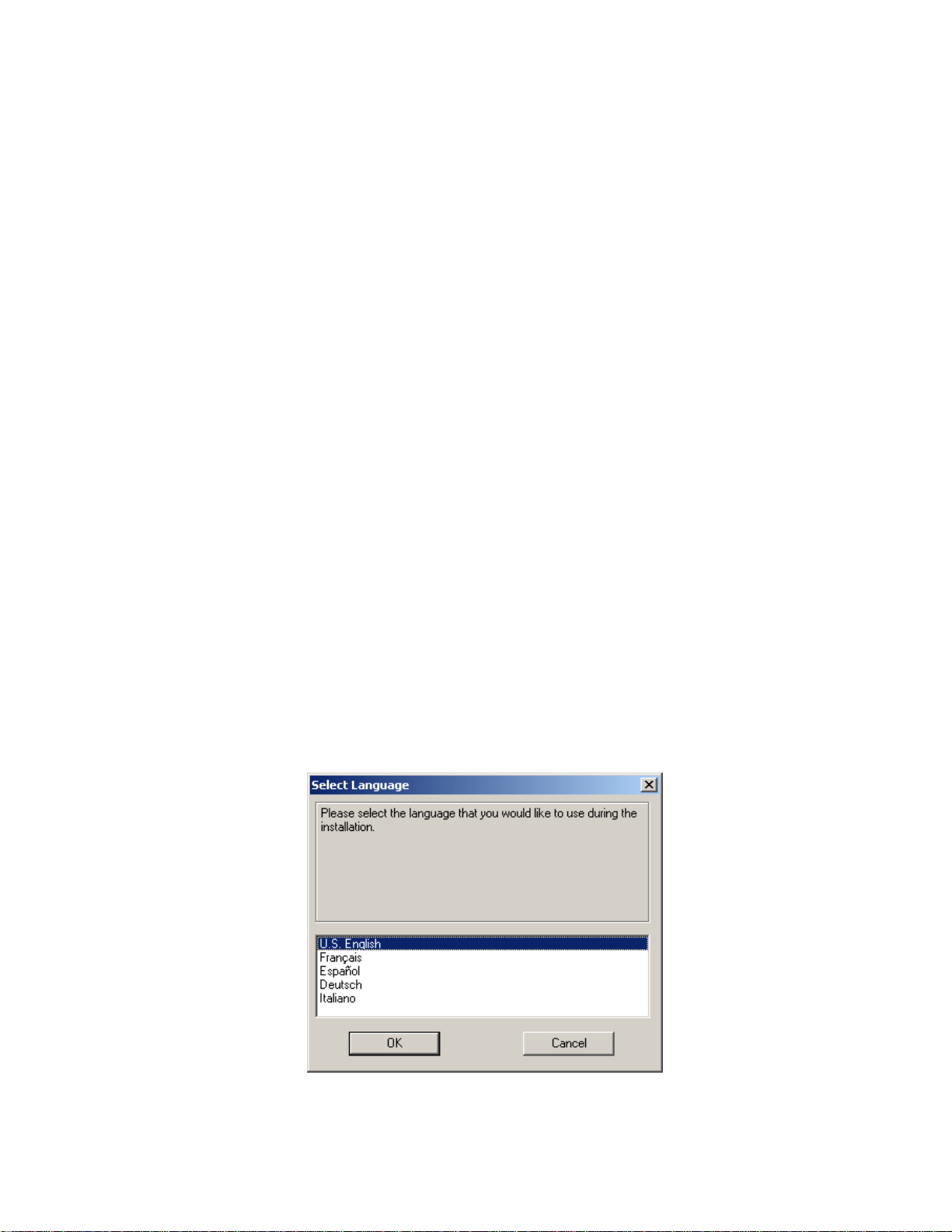
Insert the Destinator PN Disk 1 into the PC’s CD-ROM
drive, and the Destinator PN installer screen appears
automatically.
Figure 1 - Installation Language selection Pop-up
Page 11 of 118
Page 12

Destinator PN User Guide
1. From the Select language pop-up– highlight your
language preference and click OK.
2. After reading the Welcome message click Next.
3. We recommend that you use the default directory on
your PC and click Next.
Or, if you wish to install to a different installation
directory click Browse and follow the onscreen
instructions.
4. Select the default Destinator language for your PDA.
Click Next.
5. An installation confirmation window is displayed. Click
Next.
6. A status window indicates the progress of the
installation.
7. Click Finish to exit installer program.
2.3 Install Destinator PN To Pocket PC
Prerequisites
Before you install Destinator PN, please confirm that:
• Your Pocket PC has a minimum of 32 MB RAM and
96 MB external memory
• Your computer is running Microsoft Windows
98/ME/NT/2000/XP with Microsoft ActiveSync
• PC has ActiveSync loaded, running and Pocket PC is
connected
• PC has a minimum of 300 MB free for temporary files
• You have an Internet connection for online
registration
Note: The hardware and software requirements above are the minimum
recommended to run Destinator PN.
Page 12 of 118
Page 13
Install Destinator
Insert the Destinator Disk 1 into the PC’s CD-ROM drive.
Launch the Destinator Console from the start menu on your
PC.
Start > Programs > DestinatorApps > Destinator Console
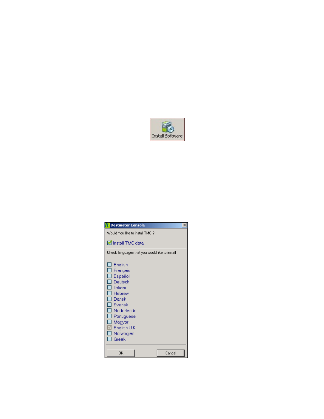
1. Click the button to install the Destinator
2. The End-User License Agreement (EULA) is
3. A window gives you the option to install the TMC
Destinator PN User Guide
Navigation System to your PDA.
displayed. Please read it carefully and if you agree,
click Yes, I Agree.
Traffic Message Channel) function, and allows you to
choose a language. See Section 6.13 TMC for more
information about this feature.
Figure 2 - Install TMC Dialog
Page 13 of 118
Page 14
Destinator PN User Guide
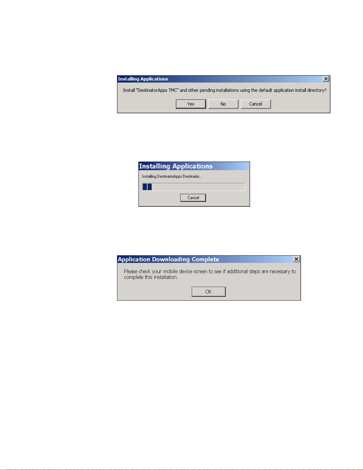
4. You are asked to which directory you would like to
install. Select Yes to install to the default directory,
which is your Pocket PC’s main memory.
Figure 3 - Install to Default Directory
5. A status window indicates the progress of the
installation.
Figure 4 - Status Window for Installation
6. A window will refer you to your Pocket PC device
screen for instructions.
Figure 5 - Refer to Device Screen
7. After the software has been successfully installed, a
“Program installation successful” message appears.
Click No. You will have an opportunity to register
later.
Page 14 of 118
Page 15
Destinator PN User Guide
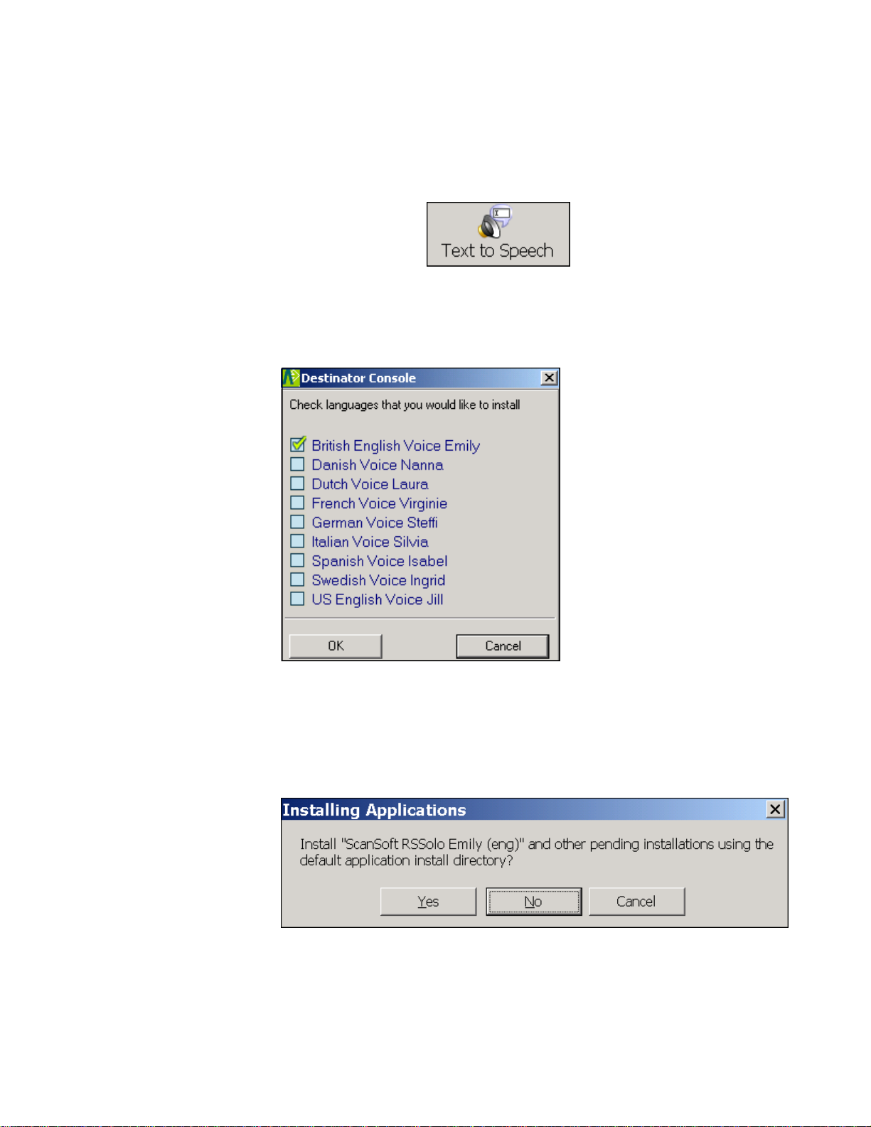
Install TTS (Text To Speech)
The TTS feature lets you hear street names as part of the
voice prompts.
1. Click on the button on the toolbar
at the top of your screen.
2. Select your language preference for the voice
prompts, and click OK.
Figure 6 - Select Language for TTS
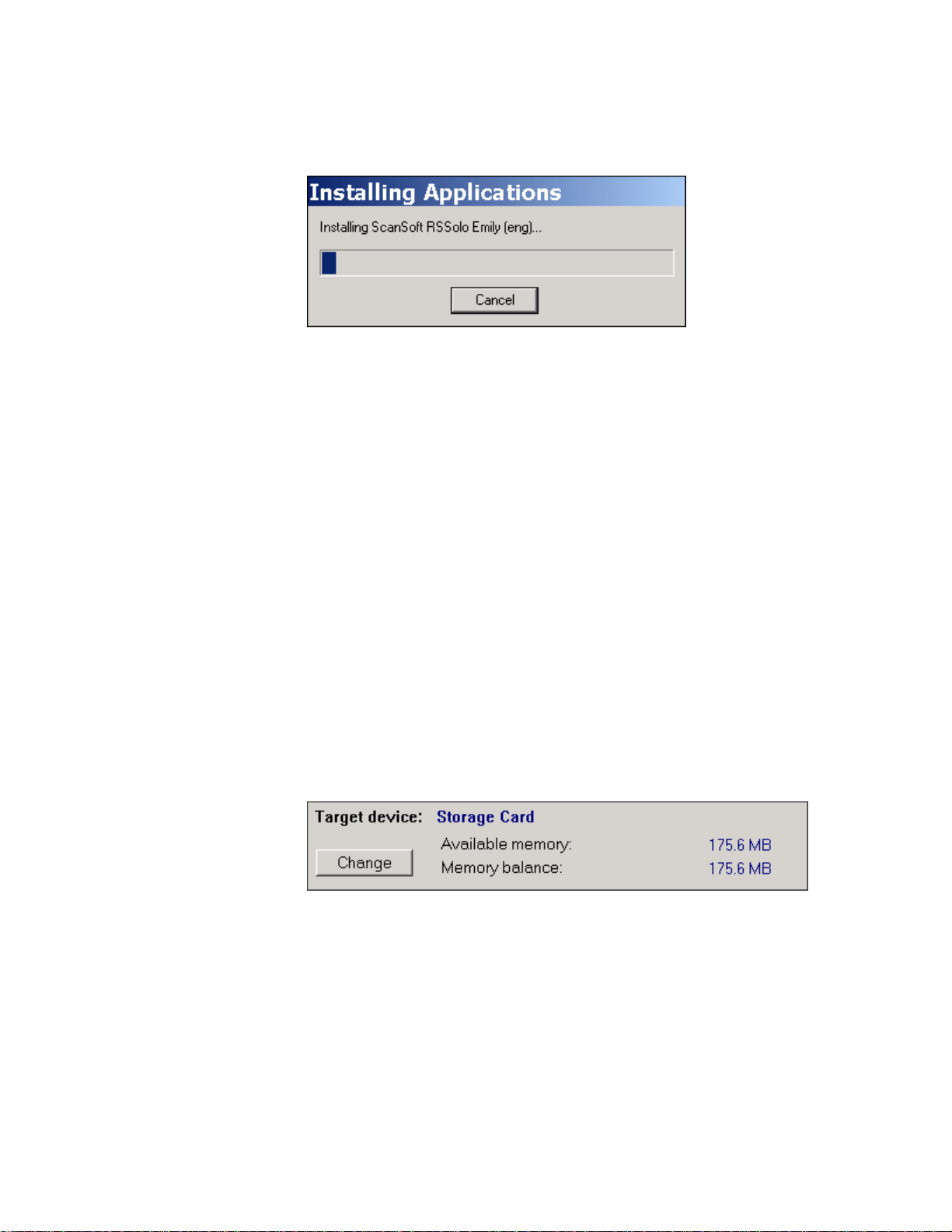
3. You are asked to which directory you would like to
install TTS. Select Yes to install to the default
directory, which is your Pocket PC’s main memory.
Figure 7 - Install TTS to Default Directory
Page 15 of 118
Page 16
Destinator PN User Guide
4. A status window indicates the progress of the TTS
installation.
Figure 8 - Status Window for TTS Installation
5. You will be prompted when the installation is
complete.
2.4 Install The Map(s)
This Section Covers:
• Where to load maps
• Selecting maps to load
• Loading maps.
Where to Load map(s)
Figure 9 - Change Target Device (Memory)
1. From Target Device press Change to choose where
to install maps.
You can install the map(s) to the Pocket PC main
memory, to a storage card plugged into the Pocket
PC, or even an external Flash Reader with
Removable Disk (fastest).
Page 16 of 118
Page 17

Destinator PN User Guide
2. In the Select Target Device dialog, highlight where to
install maps (eg: Storage Card) and click OK.
The Target Device window displays the size of the
map(s), and the available room on the storage card or
main memory.
Select Maps to Load
1. Select the map(s) you wish to load by clicking on the
map image or selecting them from the list. (√)
represents a selected map to install.
2. Press the
button.
A Confirmation Dialog is displayed. Press the OK
button to install the map(s), or the Cancel button to
exit map installation and return to select map(s). A
status window will indicate the progress of the map
installation.
3. When the map installation has completed, a
Successfully loaded message appears. Press OK.
Before you can begin navigating, you must activate
Destinator PN. See the next chapter for instructions on how
to activate Destinator PN.
Page 17 of 118
Page 18

Destinator PN User Guide
Page 18 of 118
Page 19

Destinator PN User Guide
Activation
3.1 Introduction
After the map(s) have been installed, Destinator PN must be
activated before you can begin navigating.
3.2 Voucher For License Key
If you received a Voucher to evaluate Destinator PN, note
that it is not a License Key.
You can easily redeem your voucher to get License and
Activation Keys (Activation Page), when you register at the
Destinator Community at http://activate.destinator1.com.
3 3
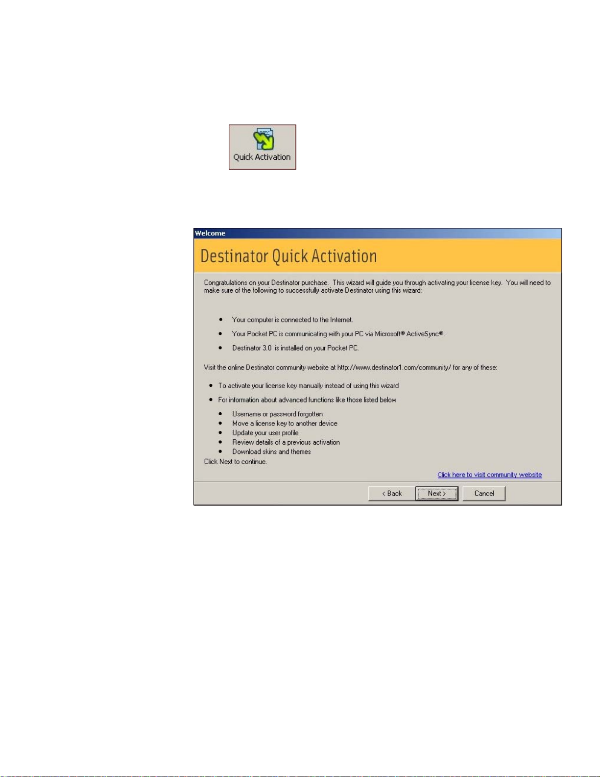
3.3 Quick Activation
Destinator
activates your Destinator product through an automated
process that is faster than activating the product manually.
For instructions on how to activate Destinator manually,
please see Appendix B.
If you have a PPCPE device, you might consider using SMS
Activation, which is described in the next section.
To activate your Destinator product with Quick Activation, do
the following:
1. Be sure your PC is connected to the Internet.
2. Be sure your Pocket PC is communicating with your
supports a feature called “Quick Activation”, which
PC via Microsoft Active Sync.
Page 19 of 118
Page 20
Destinator PN User Guide
3. Start the Destinator program on your PC.
4. From the toolbar at the top of the screen, select the
button.
5. The Quick Activation screen appears. Click Next to
continue.
Figure 10 - Quick Activation Dialog
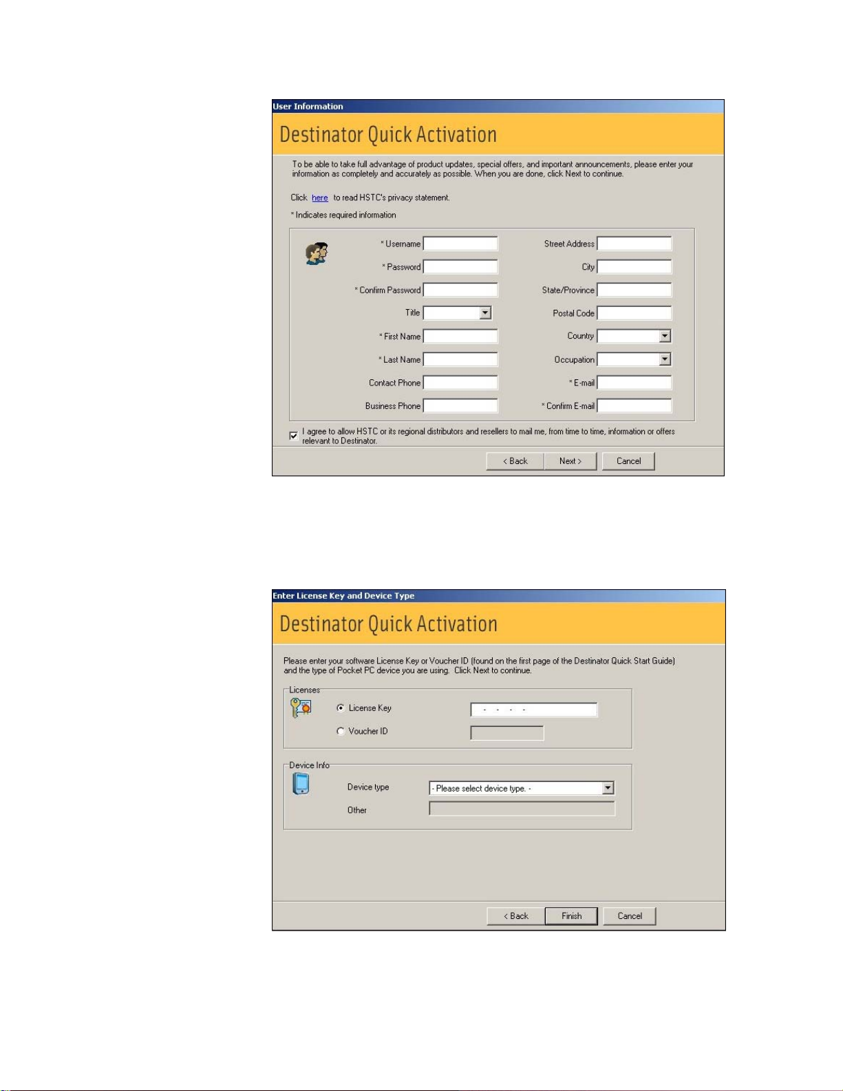
6. The User Information screen is displayed. Fill in the
required information to create your account on
Destinator Community, and click on Next.
Page 20 of 118
Page 21
Destinator PN User Guide
Figure 11 - User Information Screen
7. Enter the license key and select your device type.
Click on Finish.
Figure 12 - License Key and Device Type
Page 21 of 118
Page 22
Destinator PN User Guide
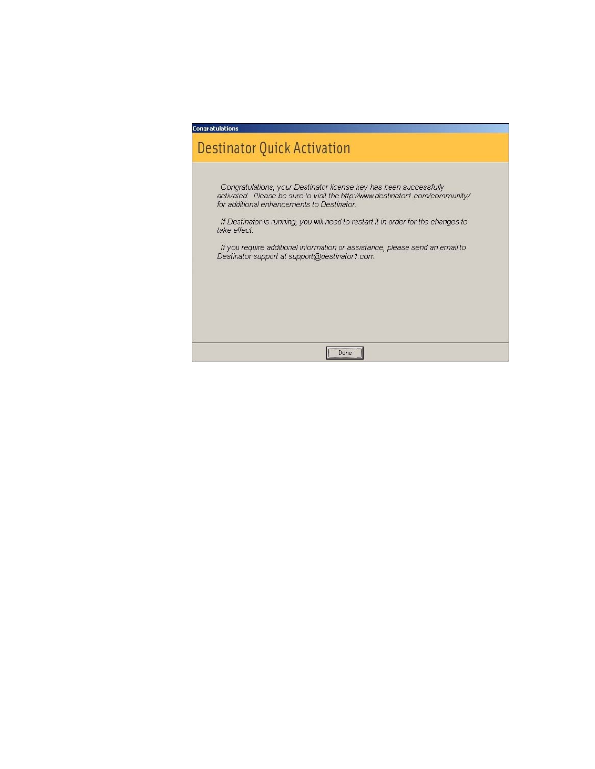
8. The message “Congratulations, your Destinator
license key has been successfully activated” is
displayed. Click on Done to close the screen.
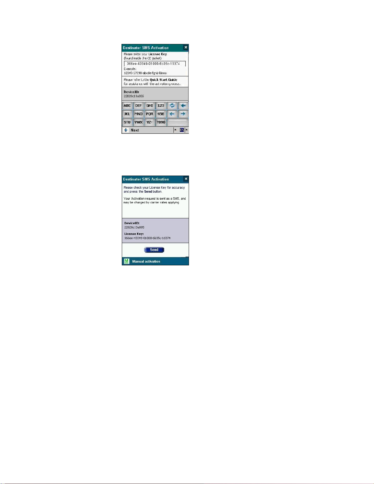
3.4 SMS Activation
Note: SMS Activation is available only if you have a PPCPE
device. If you do not have a PPCPE device, see Section 3.3
Quick Activation for instructions about activation.
If your Destinator PN is running on a PPCPE device, you
can activate Destinator PN by using SMS Activation.
1. As soon as your Destinator PN has been installed, the
Figure 13 - Quick Activation Completed
following screen will be displayed:
Page 22 of 118
Page 23
Destinator PN User Guide
2. Key in your License Key number and press Next. The
following screen is displayed:
3. Be sure you read the text in the upper portion of the
screen. Sending an SMS might mean that you will be
charged by your carrier.
If you want to continue with the SMS activation, click
on Send. You will be prompted when your activation
has been accepted.
As an alternative to SMS activation, you might wish to
use manual activation, which is described in Appendix
B. To start manual activation, click on the Manual
activation button.
Page 23 of 118
Page 24

Destinator PN User Guide
Page 24 of 118
Page 25

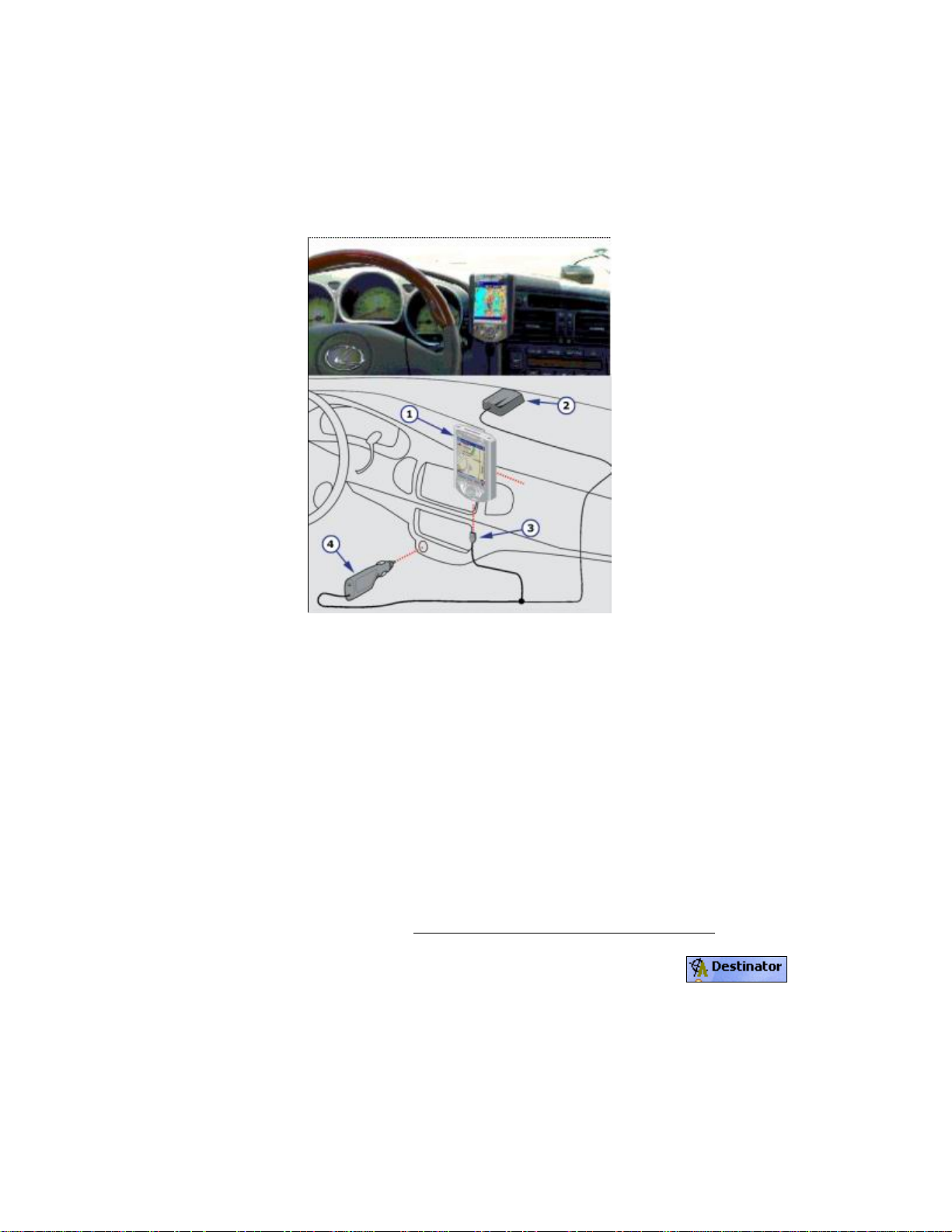
Hardware Installation
4.1 Introduction
Destinator PN User Guide
4 4
This Chapter will guide you through the Destinator PN
hardware installation procedure.
Warnings
Carefully select a safe location to install the Pocket PC device and
GPS Antenna.
DO NOT INSTALL the Pocket PC Device or GPS Antenna in any
place that could:
♦ Obstruct the driver's view of the road
♦ Interfere with vehicle controls or safety devices
♦ Cause injury to the driver or passengers
♦ Interfere with the safe deployment of the airbags
SECURE the Pocket PC device and GPS to the dashboard to
prevent it from injuring driver or passengers in the event of a
sudden vehicle movement or collision.
Page 25 of 118
Page 26
Destinator PN User Guide
4.2 Connecting the Hardware
Installing Hardware.
1. Pocket PC device.
2. GPS antenna/receiver.
3.
COM connector.
4. Cigarette Lighter Adapter.
Figure 14 - Sample Hardware Installation
If you are choosing a suitable location on the dashboard to
install the Pocket PC device (1) mount, ensure that it does
not obstruct the driver's view or interfere with other vehicle
controls.
If you are using a Destinator Bluetooth GPS Receiver,
refer to your Bluetooth GPS Receiver User Guide.
1. On your Pocket PC launch Destinator .
(Some Pocket PC may lock up if the GPS is
connected before launching Destinator).
2. Connect the GPS (2) and cable (3) to the Pocket PC
device.
Page 26 of 118
Page 27

Destinator PN User Guide
3. Plug in the Cigarette Lighter Adapter (4) to power up
the GPS Receiver and charge the Pocket PC.
4. Check that the Cigarette Lighter adaptor power LED
is ON.
Note: The GPS may take a few minutes to find its current location initially.
For best results, ensure that the GPS has a clear view of the sky.
Disconnect the adaptor when the ignition is off. This will help to
prevent unnecessary battery drain.
Page 27 of 118
Page 28

Destinator PN User Guide
Page 28 of 118
Page 29
Using Destinator PN Console
5.1 Introduction
This chapter will guide you through:
• Toolbar Overview
• Removing previous versions of Destinator
• Loading more map(s) into memory
• Selecting and loading pre-cut maps
• Activating new maps
• Setting up your preferences
Destinator PN User Guide
5 5
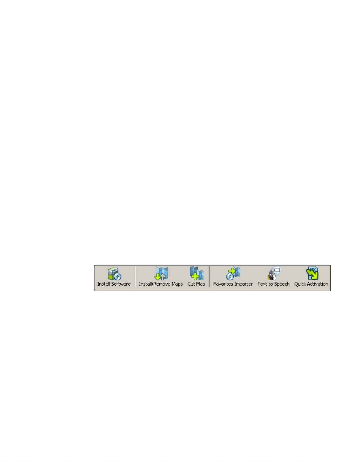
5.2 Menu and Toolbar Overview
Toolbar
Figure 15 - Destinator Console Toolbar
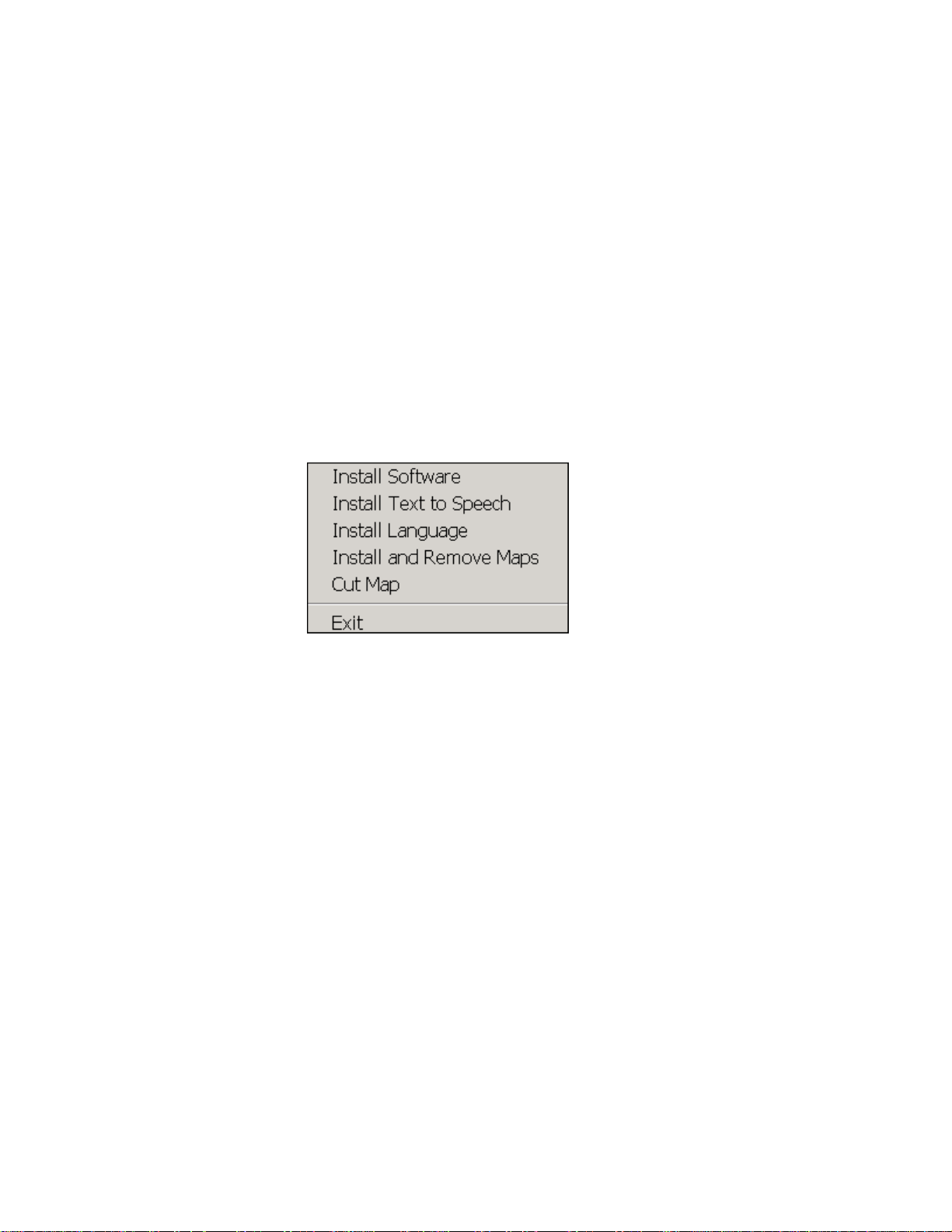
• Install Software – Installs the latest version of Destinator
software to your Pocket PC
• Install / Remove Map – Dual function of installing new or
self created maps or removing old not used maps to save
memory
• Cut Map – Allows you to create and cut own selection of
map(s)
• Favorites Importer – You can download a list of
locations from your PC to your PDA to any category
within Favorites.
Page 29 of 118
Page 30
File Menu
Destinator PN User Guide
• Text to Speech – This function inserts street names into
the voice prompts at 200 meters prior to a turn, as well as
when you reach the turn. Once installed, the TTS feature
must be enabled from the Alert Settings screen.
• Quick Activation – Launches the process for activating
your Destinator PN product using the Quick Activation
method. If you have a PPCPE device, you might
consider activating your product by using the SMS
Activation method described in Section 3.4 SMS
Activation.
• Install Software – Install the Destinator software.
• Install Text to Speech – Install the Text to Speech
feature, which includes street names into the voice
prompts at certain manoeuvres.
• Install Language – Install language preferences for use
in voice prompts and skins. After you install a language,
you can implement it by going to the Settings menu and
selecting Look & Feel (see Section 8.10 Look & Feel).
• Install and Remove Maps – Install new or remove old
maps.
• Cut Map – Cut your selection from a large map.
• Exit – Close down Destinator Console.
Page 30 of 118
Page 31

Tool Menu
Destinator PN User Guide
• Select Target Device – Select where to load map
• Remove Maps – Remove old or unused maps to save
on memory
• Refresh map data – Load new map(s) and refresh
installed map window
Help Menu
• Favorites Importer – You can download a list of
locations from your PC to your PDA to any category
within Favorites.
• Language – Select your Language to install Destinator in
(default English)
• Tutorial – Brief interactive introduction on using
Destinator
• User Manual – Provides a detail description on using
Destinator
• Destinator Customer Support – Contact Destinator
information
Page 31 of 118
Page 32

Destinator PN User Guide
• Manual Registration on the Web – Destinator
Community Registration web page
• Quick Activation – To activate your Destinator product
with Quick Activation
• About Destinator Console – Version of Destinator
Console
Exit from Destinator Console
1. When you are ready to exit the Destinator Console,
click
File > Exit.
Figure 16 - Quit Destinator Pop-up
2. You will need to confirm that you want to Exit. Press
Yes and you will exit from the Destinator Console.
5.3 Removal of Previous Destinator Versions
1. The Destinator Console automatically checks if
there is a previous version installed and will prompt
you to remove it, before installing the latest version of
Destinator.
Figure 17 - Removal of Previous Installed Destinator Pop-up
Page 32 of 118
Page 33

Destinator PN User Guide
2. Press the Yes button to completely uninstall the
previous version and re-install the new version. If you
press No, Destinator will not install and you are
returned to the Destinator Console main screen.
3. Press the Yes button to continue to install the latest
version of Destinator.
Destinator Console will display a status window to let
you monitor the installation’s progress.
After the software has been successfully installed, a
Program Installation successful message appears.
4. Click No, you will have an opportunity to register later
Now that you have installed the navigation software,
you are ready to install the maps. See Section 2.4
Install The Map(s).
You cannot install the Destinator
external Flash Reader.
navigation software to an
5.4 Creating Your Own Maps
Living in California, but need only the map and driving
directions for San Francisco? Well Destinator
that easy with its simple to use Cut Map tool.
1. From Standard Maps window select the map(s) you
wish to load by clicking on the map image or selecting
them from the list. (√) represents a selected map to
install.
2. Press the Cut Map button.
Page 33 of 118
has made
Page 34

Destinator PN User Guide
A Confirmation Dialog is displayed, press the OK
button to install the map(s), or the Cancel button to
exit map installation and return to select map(s). The
selected map is temporally loaded to hard disk.
3. The map is displayed on screen - Then Zoom In
on a section, zone, selected area or city of
interest.
Some maps are already Pre-Cut. See Selecting Pre-Cut
Maps chapter 6.
4. Use the toolbar for Address or POI selection, to
Zoom, to select a sub-region, or Crop (to select a
rectangular area to be cut).
5. Click Crop (Draws a Rectangle around area to
cut – your selection eg: San Francisco)
Figure 18 - Crop Map Selection (Rectangle) Window
Page 34 of 118
Page 35

5.5 Cutting Maps
1. Click Cut Map to create that selected zone
(map).
Destinator PN User Guide
Figure 19 - Entering a New Map name Pop-up
2. Enter an unique name as the new map name eg:
San_Frisco1.
Note: No spaces between words are allowed, but you can use
underscores to separate the words (16 character maximum).
3. Pressing Estimate gives the size of the selected map.
Do you have enough memory available? Click OK.
4. Click Cut – To automatically store the newly cut map
on your computer.
Destinator creates a default directory on your
computer, C:\DestinatorApps\New Maps, where all
cut maps are stored.
5. Click OK. From Destinator Maps Cutter, click File >
Return to Console. (You are returned to the
Destinator Console).
Page 35 of 118
Page 36

5.6 Route Cutting
Destinator supports route cutting, which allows you to create
a map composed of a travel route. To create the route, you
specify two or more points. After the route has been created
you can create a map from it and download the map to your
Pocket PC.
1. From the console, select one of the standard maps.
The route you create will be restricted to the area of
the predefined map.
2. Click on Cut Map . An enlarged image of the
map is displayed in the left-hand pane.
Destinator PN User Guide
3. Click on Route
that is displayed in the right-hand pane.
. Notice the additional window
4. To establish a point on your route, click on the desired
position on the map. A description of the point is
displayed in the right-hand pane. To more precisely
select a point, you can click on Address or POI as
the next section describes. The first point you define
is considered the starting point of the route. A route
must include at least two points.
5. Some tools you can use when creating a route:
Corridor - You can select how much surrounding
area will be included along the route’s path. You can
also choose either kilometers or miles.
Route - You can select either the quickest or the
shortest route to connect the points.
- Centers a point on the map. First, highlight
the point in the right-hand pane, and then click the
icon.
- Deletes a single point from the route. First,
highlight the point in the right-hand pane, and then
click the icon.
Page 36 of 118
Page 37

Destinator PN User Guide
- Click on this icon to delete all points from the
route.
and - Changes the numerical order of
the points on the map and in the right-hand pane.
First, highlight a point in the right-hand pane, and then
click one of these icons.
6.
When you have established all the points on the
route, click the Create Route icon. Notice that
all the points become connected by a blue line that is
bordered by a corridor. You can use any of the tools
described in step 5 to modify the route shown. If you
modify the route, you will have to recreate the route
by simply clicking on the Create Route icon again.
7. To create a map of the route, click on Cut Map
. You will be prompted to give the map a
name. The map will be displayed in the “My Maps”
section on the Destinator Console. Then, you can
download the map to your Pocket PC just as you
would download any other map as described in
Chapter 2.
5.7 Selecting Pre-Cut Maps
Selecting by Address
1. Select map to load from Standard Maps, eg: Italy.
2. Click Cut Map . The selected map (Italy) is
automatically loaded to hard disk and displayed in the
Map Cutter window.
Page 37 of 118
Page 38

Destinator PN User Guide
Figure 20 - Pre-Cut Selection Window
Do you have a specific Address, POI or Region that
you need to map? On the In Destinator Cutter, on the
Toolbar select Address POI, zoom or sub-region to
Cut.
3. If you have a address choose the Address
button, select by: City > Street and Home or City >
Intersection.
4. Eg: City - Milano then Street and Home -
Giustiniano, Viale then click Show Address.
Page 38 of 118
Page 39

Destinator PN User Guide
Figure 21 - Select Address Sub Region Window
5. In the Destinator Map Cutter main view the map is
updated and selected area to be cut is centered and
marked.
6. From Toolbar, click Crop , select on the map
where to draw rectangular zone to be cut. (Move your
curser to the area marked and draw a box around the
previously marked area).
7. Click Cut Map to cut the selected zone.
Selecting Map by Intersection
If you need to select a map by Intersection:
1. From Toolbar click Address, then click City >
Intersection.
Page 39 of 118
Page 40

Destinator PN User Guide
2. First, click City then the 1st Street and then
Intersection.
3. From the list, click 2nd Street.
4. The map view is updated and area to be cut is
centered.
5. From Toolbar > Crop , then on the map select
where to draw rectangular zone to be cut.
6. Click Cut Map to cut the selected zone. See
Cut Maps in Chapter 5.
Selecting Map by Points of Interest (POI)
1. From the Toolbar click .
2. Select the POI eg: Golf Courses.
3. Select your Golf Course. (Ensure that it is
highlighted).
4. From Toolbar > Crop . - On the map select,
with the mouse, where to draw Rectangular zone to
be cut.
5. Click Cut Map
to cut selected zone.
Page 40 of 118
Page 41

Destinator PN User Guide
Selecting by Sub Region
(If you are ready using the Destinator Map cutter see step 3).
1. On the Destinator Console select the main map to
load from, eg: Italy.
2. Click Cut Map . The Destinator Map Cutter
is displayed.
3. A list of sub-regions is, displayed on the right hand of
the selected map. Click on the sub-region to
download.
4. Click Cut Map to cut selected zone.
5.8 Loading Newly Created Maps to Pocket PC
1. On the Destinator Console, to refresh Standard Map
dialog, Click Tools > Refresh New Map Data.
2. Select the map(s) you wish to load by clicking on the
map image or selecting them from the list. (√)
represents a selected map to install.
3. In Target device, click Change to select where to
install the map(s). You can install to Main Memory,
Storage Card or Removable Disk (External Reader).
You are, prompted to select the target device where
maps are to be uploaded.
4. Choose one (highlight) eg: Storage Card, click OK.
Page 41 of 118
Page 42

Destinator PN User Guide
Confirm that there is enough memory to install map.
5. Click . A pop-up message requiring
confirmation appears.
6. Press OK to load map.
Destinator Console will display a progress window to
let you monitor the installation’s progress.
7. When the map installation has completed, a
Successfully loaded message appears. Press OK.
5.9 Removing Map(s) from Memory
If you do not have Destinator Console launched:
1. Insert the Destinator Disk 1, into the CD-ROM in your
desktop computer, this automatically launches the
Destinator Console.
Figure 22 - Change Target Device (Memory)
2. In Target device click Change, select from where
(which memory) to remove map(s). This will update
the Installed Map Window.
3. The Installed Map Window displays a list of all the
loaded maps available. Click in the check box (√)
beside the map(s) you wish to remove.
Page 42 of 118
Page 43

Destinator PN User Guide
4. Press the button to remove the
selected map.
5. Destinator requires that you confirm that you wish to
remove the selected map(s).
6. Press Yes, the selected map(s) are removed from
memory.
5.10 Activating New Maps
If you have purchased extra maps or upgrades, you may
need an addition(al) activation key(s) before you can use
them.
For example if you switch maps to an unregistered map, you
will be prompted to register the map with the following Popup message.
Figure 23 - Map Not Registered Pop-up
Note: You cannot use unregistered maps on Destinator.
1. Click YES. The Destinator Activation Page is
displayed.
Page 43 of 118
Page 44

Destinator PN User Guide
Figure 24 - Destinator Activation and Congratulations Dialogs
2. Click +New to add a new license. The
Congratulations Page is displayed. Do not enter
anything on this screen yet. Leave it as is.
See Online Activation in Chapter 3.
5.11 Removing Navigation Software
Remove the Destinator navigation software using the
following method:
1. Insert the Destinator Disk 1 into the CD-ROM drive in
your desktop computer to launch the Destinator
Console.
2. Click File > Remove Software. You will need to
confirm that you wish to remove Destinator and
Maps. Press OK.
This will remove the complete Destinator
navigational system installation - software and maps
from your Pocket PC device.
Page 44 of 118
Page 45

Destinator PN User Guide
5.12 Exit From Destinator Console
1. If you need to exit the Destinator Console File > Exit.
You will need to confirm that you want to Exit the
Destinator Console.
2. Press Yes and you will exit.
Page 45 of 118
Page 46

Destinator PN User Guide
Page 46 of 118
Page 47

Navigating a Route
6.1 Introduction
This chapter will help you to define and plan a route. You
will be able to select a destination, set your origin, or plan a
journey. The route calculated in real time is from your
current GPS position.
There are several ways to determine your destination using
the Menu button ( ). You can navigate to:
• An Address
Destinator PN User Guide
6 6
• An Intersection
• A ZIP/Postal Code
• A POI (Point Of Interest)
• An Address in Favorites
• An Address In History
• A Contact
• An SMS Inbox Item
Page 47 of 118
Page 48

6.2 Map Description
There are various buttons and icons on the map screen that are
used to plan and view a route.
Driving Directions Button
Destinator PN User Guide
Exit Button
View Selector Button
Compass Button
Menu Button
GPS - Generated
Statistics Button
Route Details Button
Length Scale Indicator
Figure 25 - Main Map View
Location Icons
Zoom Scroll Bar
Current Location
Home Button
Battery Status
Indicator
GPS Status
Button
(or in Pedestrian Mode) shows your current location
while in Navigation Mode.
(or in Pedestrian Mode) shows your last known GPS
location while in Navigation Mode. This is not your current
location, because there is no valid GPS information at this time.
(or in Pedestrian Mode) shows the Origin in Planner
Mode.
See Section 8.7 Route Settings for descriptions of Navigation
Mode and Planner Mode.
Page 48 of 118
Page 49

Destinator PN User Guide
Dynamic cursor
Destinator PN's screen cursor has the capability to automatically
change its appearance so that you will be informed of several
important navigation conditions:
• The cursor indicates if you are in Car or Pedestrian mode
• The cursor indicates if you are driving at high or low speeds.
The cursor becomes elongated at higher speeds and wider at
lower speeds.
• The cursor displays a shadow that shows the position of the
Sun. This is especially important if you are using Destinator
PN in Pedestrian mode. By positioning yourself so that the
shadow that you cast is in the same position as the shadow on
the screen, you can be assured that you are walking in the
right direction.
• The cursow shadow disappears during night driving.
Map Screen Buttons
Toggles between Turn by Turn details and a complete list of
Driving Directions.
Toggles between 2D, 2D Night, 3D and 3D Night views. The
icon indicates the next view to be displayed.
Shows magnetic direction as you move.
Lets you define and plan your route via the Destination
Menu. Also allows you to access the Options Menu and Settings
Menu. Indicates whether you are in Vehicle Mode ( ) or
Pedestrian Mode (
). You can change modes by holding
down the button for several seconds, or by opening the Options
Menu and pressing either or . In Pedestrian Mode,
the navigation radius is restricted to 10 kilometres (6 miles).
Displays details about your route, such as ETA, ETR and the
distance to your destination.
Page 49 of 118
Page 50

Destinator PN User Guide
Displays GPS–generated information, such as UTM
(Universal Transverse Mercator), geographic position, current
location, altitude, and speed. The icon indicates the next item to
be displayed.
Displays GPS status, such as information about your satellite
fix, and the latitude, longitude and altitude of your position. The
icon appears green when there is a GPS fix, and red when there
is no GPS fix. Also provides a link to the GPS Settings screen.
Displays battery status. When the battery power is low, a
message box will appear.
Calculates a route to a pre-set POI or address.
Lets you exit from the Destinator PN application.
Menu Button
This button is shared by two functions: Vehicle Mode ( ) and
Pedestrian Mode ( ). You can toggle between these two
modes by holding down this button for several seconds. In
Pedestrian Mode, the navigation radius is restricted to 10
kilometres (6 miles).
Press the Plan Button to open the Destination Menu. Pressing
the and buttons at the bottom of the
screen allows you to cycle between the Destination Menu, the
Options Menu and the Settings Menu as seen in Figure 26.
Page 50 of 118
Page 51

Destinator PN User Guide
Figure 26 - Menu Structure
Landscape View
Destinator PN supports full landscape operation that is compatible
with Windows Mobile SE devices. This view is particularly useful
for navigation when you want to see more of your lateral
surroundings. Destinator PN adjusts the screen view to fit either
portrait or landscape mode.
6.3 The Destination Menu
1. At the map screen, press the button to open the
Destination menu.
2. You can choose your destination from the following
options:
Page 51 of 118
Page 52

Destinator PN User Guide
• Address list
• Point of Interest (POI) list
• Favorites list
• History list
• Contact list
• SMS Inbox
3. From your current position, the route is calculated and
displayed as a blue line. The green triangle
represents your Origin (or departure point).
Origin
Figure 27 - Main Map View Dialog
Page 52 of 118
Route
Page 53

Destinator PN User Guide
6.4 Navigate To An Address (or Intersection)
When you navigate to an address, there are several ways of
defining your destination. You can navigate to a destination
by selecting an address, a ZIP/Postal Code, or an
intersection.
The Cross Region Navigation feature lets you navigate a
route that extends across more than one region on the same
continent, without having to switch maps. This feature
becomes available only when you have the following maps
installed: the map of your origin, the map of your
destination, and a map of the major roads for that continent
(e.g. major roads of Europe). When the Cross Region
feature is enabled, you can press Region to display a list of
installed maps, and select the map pertaining to your
destination. Destinator PN will automatically change maps
as you travel across regions, displaying your route at the
same level of detail as you drive. You will not need to switch
maps during your route.
Page 53 of 118
Page 54

Destinator PN User Guide
Figure 28 - Address Screen with Region Feature
The default order for entering your destination is City ->
Street -> Number, but by clicking on the button, you can
cycle through the different ways of specifying your address.
Click on this
button to change
your search type.
Figure 29 - Address Search Screen
Lets you search for an address by first entering the
City, then the Street, then the Number.
Lets you search for an address by first entering the
Street, then the City, then the Number.
Lets you search for an address by first entering the
ZIP/Postal code, then the Street, then the Number.
Lets you search for an address by first entering the
Street, then the ZIP/Postal code, then the Number.
Page 54 of 118
Page 55

Destinator PN User Guide
Lets you search for an intersection by entering the
City, the first Street, then the intersecting Street.
For example, to navigate to an address using the City ->
Street -> Number search order:
1. Press Region if you are navigating a route across
several maps. Highlight your selection from the list of
installed maps. (If only one map is installed, you will
not see the Region option.)
2. Press City and use the keyboard to enter the first few
characters of the city name. The scroll list will update
accordingly. Press the button to expand the list
for easier scrolling. You can also change your
keyboard from uppercase to lowercase by pressing
the button.
3. Press Street to display a list of street names for the
selected city. Select the street name by entering the
first few characters or by scrolling down the list (eg:
Birch, Ave).
4. Not all cities/towns are mapped to the street level. In
such cases, the software will display Street data not
found. You can still navigate to the city as selected.
5. Press Number and enter the number using the
keyboard.
6. Once you have entered your destination, there are
several options available on the toolbar found at the
bottom of the screen.
Calculates and displays your route, which
is shown as a blue line on the map.
Shows the destination on the map and
displays its details.
Page 55 of 118
Page 56

Destinator PN User Guide
Allows you to add the destination to your
Favorites Folder, or to set it as your Origin.
If you are using a PPCPE device, you can also send
(as an SMS message) the location to someone in
your Contacts list. Click on Send Location. The SMS
message will automatically include the location of the
highlighted address. See Appendix C for more
information about sending locations.
As you drive, Destinator PN provides you with turn-by-turn
voice and visual directions, letting you know when your next
turn is coming up until you arrive at your destination.
If you don’t know the entire name of a city or street, type in part of the
name and press the button. This will display a list of all names
containing your typed sequence.
For more information on a City, Street or Number click to display
details about the location, such as its city, street name, and latitude and
longitude coordinates.
Note:
Some smaller (sub-) municipalities may not contain street data. In such cases,
please choose the larger (super-) municipality displayed in parentheses to search for
these streets. Alternatively, you can change the search order to Street>City or
ZIP/Postal Code>Street to find street data for the smaller municipality.
6.5 Navigate To A Point of Interest (POI)
Page 56 of 118
Page 57

Destinator PN User Guide
The Points of Interest (POI) list is a collection of potential
destinations of interest in predefined categories. POIs are
identified on the map by various icons (eg: Restaurants).
POI navigation is especially handy when you need to find a
facility, attraction or amenity by category or type. For
example, you can ask Destinator PN to guide you to the
closest bank, mall, hotel, restaurant, gas station, etc.
The Cross Region Navigation feature lets you navigate a
route that extends across more than one region on the same
continent, without having to switch maps. This feature
becomes available only when you have the following maps
installed: the map of your origin, the map of your
destination, and a map of the major roads for that continent
(e.g. major roads of Europe). When the Cross Region
feature is enabled, you can press Region to display a list of
installed maps, and select the map pertaining to your
destination. Destinator PN will automatically change maps
as you travel across regions, displaying your route at the
same level of detail as you drive. You will not need to switch
maps during your route.
1. From the Destination Menu, press the POI button.
2. Press Region if you are navigating a route across
several maps. Highlight your selection from the list of
installed maps. (If only one map is installed, you will
not see the Region option.)
Figure 30 - POI Regions
3. Press Category and highlight your selection from the
list of POI categories. For example, we can search
for the nearest restaurant.
Page 57 of 118
Page 58

Destinator PN User Guide
Figure 31 - POI Categories
At this point, you can display all the items within a category on the
map screen by tapping the button beside any of the
categories. When selected, the button will appear as . Press
to return to the map screen.
4. With Restaurants highlighted, tap Items to display a
list of Restaurants in your area. Press the
button to expand the list The POIs are listed in order
of distance. To sort them alphabetically, press the
button.
5. Highlight your choice and click to calculate
your route. The route is shown on the map as a blue
line from your current GPS position.
6. You can select
to preview your destination
on the map, or press to add the destination
to your Favorites or to set it as your Origin. Select
Settings to define your Search Radius and Search
Center.
If you are using a PPCPE device, you can also send
(as an SMS message) the location to someone in
Page 58 of 118
Page 59

Destinator PN User Guide
your Contacts list. Click on Send Location. The SMS
message will automatically include the location of the
highlighted POI. See Appendix C for more information
about sending locations.
As you drive, Destinator PN provides you with turn-by-turn
voice and visual directions, letting you know when your next
turn is due.
6.6 Navigate To A Favorite
You can select a destination from your list of stored
Favorites. (The next section describes how to save an item
to your Favorites list.)
A Favorite is an address or destination previously stored by
you for quick and easy retrieval. You can also save, edit or
delete destinations from this folder.
1. From the Destination menu, press the Favorites
button. Your list of Favorites categories is displayed.
2. Highlight My Favorites and tap Items. A list of stored
items is displayed.
3. Highlight your selection and click
to
calculate your route. The route is shown on the map
as a blue line from your current GPS position.
4. You can also select
to preview your
destination on the map, or press to edit or
delete your choice, or to set it as your Origin.
If you are using a PPCPE device, you can also send
(as an SMS message) the location to someone in
Page 59 of 118
Page 60

As you drive, Destinator PN provides you with turn-by-turn
voice and visual directions, letting you know when your next
turn is due.
6.7 Save To Favorites
When selecting a Destination which you may use regularly,
you can save it to your personalized Favorites list.
Destinator PN User Guide
your Contacts list. Click on Send Location. The SMS
message will automatically include the location of the
highlighted Favorite. See Appendix C for more
information about sending locations.
1. At the map screen, press the
Destination menu.
button to open the
2. Select and specify your desired destination as
described previously, be it from Address, POI,
History or Contacts.
3. To save the location in your Favorites folder, click the
button and select Favorites. The Edit Item
Properties screen is displayed.
Figure 32 - Adding An Item to Favorites
Page 60 of 118
Page 61

Destinator PN User Guide
4. Enter a name and comment that will help you
recognize the item in future.
5. Enter a new category name (eg: Must see) or select
an existing one and press Save.
Your favorite destination has now been stored for future use.
6.8 Navigate To A History Item
History allows you to select an existing destination from a
list of previously traveled routes. The software automatically
stores the last few destinations in memory. As each new
route is added to the top of the list, the older destinations at
the bottom are erased.
Figure 33 - History List
1. From the Destination Menu, press the History button
to display your list of previously traveled routes.
Page 61 of 118
Page 62

Destinator PN User Guide
2. Highlight your selected History item and click
to calculate your route. The route is
shown on the map as a blue line from your current
GPS position.
3. You can also select to preview your
destination on the map, or press to add the
destination to your Favorites or to set it as your
Origin.
If you are using a PPCPE device, you can also send
(as an SMS message) the location to someone in
your Contacts list. Click on Send Location. The SMS
message will automatically include the location of the
highlighted History item. See Appendix C for more
information about sending locations.
6.9 Navigate To A Contact
Your PDA includes a Contacts folder, which can be found
under the Start menu. The Contacts folder contains a list of
contact information for people and places. Destinator PN
lets you use the address specified in a contact as a
navigation destination.
1. From the Destination Menu, press the Contacts
button to display your list of contacts.
Page 62 of 118
Page 63

Destinator PN User Guide
Figure 34 - Contacts List
2. Highlight the contact you want to navigate to, and
press Info to display detailed information for your
contact. Confirm that this is the address you want to
navigate to.
Figure 35 - Contact Info Screen
3. Press Address and a list of addresses that closely match
the one defined in the contact is displayed. If no address
information exists for that contact, a message box will
appear.
Page 63 of 118
Page 64

Destinator PN User Guide
Figure 36 - List of Possible Addresses
4. Highlight your selection and click
your route. The route is shown on the map as a blue line
from your current GPS position.
5. You can also select to preview your destination
on the map, or press to edit your choice, add
it to your Favorites, or set it as your Origin.
If you are using a PPCPE device, you can also send (as
an SMS message) the location to someone in your
Contacts list. Click on Send Location. The SMS
message will automatically include the location of the
highlighted Contact. See Appendix C for more
information about sending locations.
6.10 Navigate To An SMS Inbox Item
to calculate
Destinator PN allows you to receive a location from
someone via an SMS message. This feature is available
only if you have a PPCPE device. In order to send you a
location, the sender must also have a PPCPE device that is
running Destinator PN, or a Destinator SP (SmartPhone).
The SMS message will include a location to which you can
navigate.
When you are at the main map screen, you will be notified
by an Alert Icon when an SMS message is received. To
navigate to the location sent to you via an SMS message:
1. Tap on the Alert Icon to open the SMS Inbox. A list of
received SMS messages is displayed.
Page 64 of 118
Page 65

Destinator PN User Guide
2. The item at the top of the list is the most recent SMS
message. When you highlight this item, information
about the location is displayed at the bottom of the
screen.
3. With the SMS message highlighted, click
to calculate your route. The route is shown on the
map as a blue line from your current GPS position.
4. You can select to preview your destination
on the map, or press to add the destination
to your Favorites or to set it as your Origin.
If you are using a PPCPE device, you can also send
(as an SMS message) the location to someone in
your Contacts list. Click on Send Location. The SMS
message will automatically include the location of the
highlighted item. See Appendix C for more
information about sending locations.
You can also access your SMS Inbox from the Destination
Menu. The SMS Inbox button will be enabled only if you
have a PPCPE device.
6.11 Navigate To A Point on the Map
You can navigate to any point on the map by tapping its
location directly on the map screen. This feature is especially
handy when you want to navigate to a specific point you see
on the map, but you don’t have its street address.
Page 65 of 118
Page 66

Destinator PN User Guide
Dialog Box on the
Map Screen
Figure 37 - Map Cursor Dialog
1. Use the stylus to scroll or drag the map to a specific
point, and then tap the desired location.
2. A dialog box displays the address of that point, and
lets you select whether you want to navigate to it,
recalculate your route, add the point to your Favorites,
or set it as your Origin (if you are in Planner Mode).
3. To clear the cursor dialog, just tap the screen again.
4. If you are using a PPCPE device, you can also send
(as an SMS message) the location of any point on the
map to someone in your Contacts list. The SMS
message will automatically include the location of the
highlighted History item.
Tap on any point on the map and click on Send
Location. See Appendix C for more information about
sending locations.
If you need to reset the point of Origin, tap the map screen
to open the Cursor Dialog, and select Set As Origin. All
new route calculations will use this as the starting point, but
only if you are in Planner Mode. In Navigation Mode, your
current GPS location is always your Origin.
Page 66 of 118
Page 67

Destinator PN User Guide
6.12 Trip Planning
Trip planning is useful when you have more than one
destination along your route. This process is similar to the
procedures used to enter or select a destination and initiate
navigation, except that you must be in Planner Mode.
When you press , the Route is calculated in stages, from
the departure point to the first waypoint. Once you’ve reached the first
waypoint, the route is recalculated to the second waypoint, and then
recalculated to the third waypoint, and so on.
How to Use Trip Planning
Use the following method to plan a trip:
1. Ensure you are in Planner Mode. To do this, press
the button and cycle to the Settings Menu.
2. Press Route Settings
select Planner mode.
3. Press the
screen.
button to save and return to the map
and for Routing mode,
Page 67 of 118
Page 68

Destinator PN User Guide
4. At the map screen, press the button and select
Trip Planner from the Destination menu.
Note: If this is the first time you are using Trip Planner you will need
to create a Trip Folder in which to store your trip details. You can use any
name. For this example we will be using My trip.
5. From the tool bar at the top of the screen, click Tools
and select Add to create a trip folder.
Figure 38 - Adding a Trip Folder
6. Enter the name of your trip folder (e.g. My trip) and
press Save. You can now enter the waypoints of your
trip.
What is a waypoint? A waypoint is a stop or break in your journey, along
a predefined route.
7. Highlight your trip folder, and press Waypoints above
to define your waypoints.
8. From the tool bar at the bottom, click Tools and
select Add to define your waypoints.
Page 68 of 118
Page 69

Destinator PN User Guide
9. Select the address of your first waypoint – be it an
Address, POI, Favorites or History – and press
.
10. In the Edit WayPoint Properties screen, you can
change the name or details of the waypoint. Press
Save to add to your trip.
Repeat steps 6 to 9 to enter all the waypoints.
Figure 39 - Trip Planner and Waypoints Dialogs
11. Select the Show button to view the complete
route. The first part of the route is shown as double
blue lines. The remaining parts of the route are shown
in a series of single line vectors.
12. Using or , you can
change the order of your waypoints to suit your
purposes.
13. You can also click on Tools > Optimize, which will
automatically sort the waypoints for the most effective
and quickest route.
14. To calculate the route, press Navigate
.
The route is shown as a blue line from your current
GPS position.
Page 69 of 118
Page 70

Destinator PN User Guide
* Remember to change back to Navigational Mode. *
See Section 8.7 Route Settings for a description of Navigation
Mode and Planner Mode.
Page 70 of 118
Page 71

6.13 Avoid Roads
You can specify that certain roads be excluded from your route
calculations. For example, you may prefer to not travel on any
toll roads.
1. From the Destination Menu, press the Avoid Roads
Destinator PN User Guide
button to display a list of road categories.
Figure 40 - Avoid Roads (Restrictions)
2. To place restrictions on a desired road category,
highlight Restrictions and press or to
suit your preference. Press to add a new
category.
3. Tap on Items to list all the roads in a highlighted
category. To specify restrictions for a particular road,
highlight it and press or . To preview
a highlighted road on the map screen, press the
button and select Show.
Page 71 of 118
Page 72

Destinator PN User Guide
6.14 TMC
Figure 41 - Avoid Roads (Items)
4. Once you have specified your road restrictions, press
to return to the map screen.
Destinator PN supports TMC (Traffic Message Channel).
TMC messages are national and regional public radio FM
transmissions that are used to inform drivers of traffic,
weather, and other driving conditions. TMC information is
received by your PDA’s TMC-enabled GPS receiver and
monitored by Destinator PN software. Destinator PN can
automatically reroute your travel to avoid areas that TMC
indicates might be troublesome to drivers. For instance, if
there is a traffic jam, storm, or accident in your vicinity,
Destinator PN can recalculate your route to avoid the
problem. Note that TMC is currently not broadcasted in
North America.
Page 72 of 118
Page 73

Destinator PN User Guide
Follow the procedure below to configure TMC settings. Be
sure you have first enabled TMC by pressing the
button, clicking on , and placing a check mark
(√) in the box beside TMC GPS.
1. From Destination menu, select to display the
TMC Inbox.
2. Select Settings to display the TMC Settings dialog.
Configure the settings on the dialog.
TMC Events: Check the boxes corresponding to
events that you want the Destinator PN software to
monitor when it needs to recalculate your route. If you
clear all events, Destinator PN will not report any
TMC occurrences.
TMC Effective Radius: Select the maximum effective
distance that will be used in reporting TMC events.
Destinator PN will process only those TMC events
that occur within this radius of your constantlychanging position on the road.
TMC Avoidance: Check this box to cause Destinator
PN to automatically recalculate your route to avoid
TMC events that it is monitoring. If you do not select
this option, you will have to manually select which
TMC event is to be avoided and which is to be
ignored, as the next section describes. You will still be
alerted to TMC events whether you check this box or
not.
3. Close the TMC Settings dialog and then close the
TMC Inbox.
To View TMC Events
1. From the Destination menu, select TMC to display the
TMC Inbox.
2. To see a TMC event on a map, highlight the event
and select Show.
Page 73 of 118
Page 74

Destinator PN User Guide
Figure 42 - TMC Inbox
3. To search for TMC events that are being broadcasted
by other FM channels, select the arrows in the upper
right and left corners of the screen. The outside left
and right arrows scan FM stations continuously for
TMC information. The inside arrows let you adjust the
FM frequency station by station. The frequency and
call name of the station currently received is displayed
in the upper portion of the screen between the arrows.
To Enable a TMC Event
(Manual avoidance only)
If you have chosen automatic avoidance, Destinator PN will
recalculate your route automatically to avoid TMC events
that affect your route.
However, if you have not chosen automatic avoidance, you
must manually select the TMC events that you want
Destinator PN to avoid.
To select a TMC event to avoid:
1. From the Destination menu, select TMC to display the
TMC Inbox.
2. Highlight the TMC event you want Destinator PN to
avoid in your route calculation and select the Avoid
button. The Avoid button is available only if you have
not chosen automatic avoidance. In addition, once
Page 74 of 118
Page 75

Destinator PN User Guide
you avoid a TMC event in manual mode, the Avoid
button will not be available for that TMC event again.
TMC Banner
Whenever Destinator PN receives a TMC event that occurs
within the effective radius, a scrolling banner is displayed on
the bottom of the map screen. The banner briefly describes
the TMC occurrence.
Figure 43 - TMC Message Displayed on Map
Page 75 of 118
Page 76

Destinator PN User Guide
Page 76 of 118
Page 77

7.1 Introduction
Destinator PN User Guide
7 7
Options
There are various route and map options available from the
Options Menu.
This chapter contains the following topics:
• Showing your Route
• Displaying Directions
• Canceling your Route
• Recording and Playing Back a Route
• Switching Maps
• Selecting Travel Mode
• Getting Help
Page 77 of 118
Page 78

Destinator PN User Guide
7.2 The Options Menu
The Options Menu provides choices for displaying your route,
displaying your driving directions, canceling a route, playing
and recording a route, switching maps, selecting your mode of
travel, and getting help with basic navigation.
7.3 Show Route
This option displays your route on the map screen in its
entirety, plus details such as the address of and distance to
your destination, the ETA (Estimated Time of Arrival), and the
ETR (Estimated Time Remaining).
7.4 Driving Directions
This function displays a visual list of your route, distances to
each maneuver, and street names. By using the scroll bar on
the right hand side, you can scroll through the entire route.
Tapping on the maneuver twice displays that part of the route.
Page 78 of 118
Page 79

Destinator PN User Guide
Voice and visual prompts (displayed at the top of the screen)
are provided at varying intervals to indicate your next turn or
change of direction.
Figure 44 - Driving Directions
The Driving Directions screen also gives you several route
options:
Show Route
Displays your route on the map screen in its
entirety, plus details such as the address of your destination,
the ETA, and the ETR.
Cancel Route
Cancels and clears the route from the map
screen.
Show Turn
map screen, including the street name, distance to it, and an
arrow diagram to indicate the turn. You can also use the
Prev and Next arrows to scroll to the previous or next turn.
Displays the highlighted portion of the list on the
Page 79 of 118
Page 80

Avoid Turn
particular turn or maneuver.
7.5 Turn By Turn
This view indicates the distance to your next turn, and the
name of the next street immediately after completing the
previous turn.
Voice and visual prompts are displayed at varying intervals to
indicate your next turn or change of direction.
Destinator PN User Guide
Will recalculate your route to exclude this
Figure 45 - Turn by Turn Dialog
Page 80 of 118
Page 81

7.6 Cancel Route
Cancels and clears the route from the map screen.
7.7 Play
Destinator PN User Guide
This feature allows you to record your route as you’re traveling,
and then to play it back on the map screen at a later time.
From the Play/Record screen, you can record a route, play
back a route, change the speed of the playback, and delete
recordings. Pressing returns you to the map screen.
7.8 Switch Maps
This feature lets you switch between your maps. The Switch
Maps screen also displays details and version numbers of your
maps, and allows you to delete maps.
7.9 Travel Mode
You can further define your route according to whether you are
traveling by car or on foot. This button lets you switch to
Page 81 of 118
Page 82

7.10 Help
7.11 About
Destinator PN User Guide
Pedestrian Mode or Vehicle Mode. In Pedestrian Mode, the
navigation radius is restricted to 10 kilometres (6 miles).
This button launches an abbreviated help file with basic
navigational definitions and instructions.
Displays software version and details about your Destinator PN
application.
Page 82 of 118
Page 83

8.1 Introduction
Destinator PN User Guide
8 8
Settings
You can easily change the default settings of maps, views
and route parameters to suit your personal preferences.
This chapter contains the following topics:
• GPS Status
• Home Button Settings
• General Settings
• Map Settings
• Route Settings
• Alert Settings
• Visual Notifications
• Look & Feel
Page 83 of 118
Page 84

Destinator PN User Guide
8.2 The Settings Menu
The Settings Menu allows you to change the settings which
determine how your route is calculated or displayed.
8.3 GPS Status And Settings
Destinator PN uses GPS signals to pinpoint your location.
In Navigation mode, the software automatically acquires
GPS signals and constantly updates your vehicle's location
and position. The GPS may take a few minutes to find its
current location initially. For best results, ensure that the
GPS has a clear view of the sky.
Page 84 of 118
Page 85

Destinator PN User Guide
Figure 46 - GPS Status Screen
To view your GPS configuration, click on the
button. You can access this button via the Settings Menu >
GPS Status, or by clicking on the button on the map
screen.
Figure 47 - GPS Settings Dialog
GPS Settings Configuration menu:
1. COM Port - Defines the Communications Port.
2. Baud Rate - Transmission rate of data.
Page 85 of 118
Page 86

Destinator PN User Guide
3. Protocol - Default is NMEA.
Automatic reconnect – Select this option to ensure
automatic reconnection whenever the GPS signal is lost.
TMC GPS (Real Time Traffic) – Select this option to enable
the TMC function. See Section 6.14 TMC for a detailed
description of this feature.
Find GPS – Searches for and locates the GPS signal.
Set GPS - Sets the GPS Configuration.
Press the button to save your selections and return to
the GPS Satellite graphic screen.
8.4 Home Button Settings
The Home Button Settings button lets you define an address
or POI as your home destination. Whenever you want to
navigate to your home destination (for example, the nearest
gas station), press the
In the Home Button Settings screen, select either POI Mode
or Address Mode to set your desired destination.
button.
Page 86 of 118
Page 87

Destinator PN User Guide
Figure 48 - Home Button Settings Screen
Press the button to save and return to the map screen.
Now, when you press the button, Destinator PN will
automatically calculate a route to this destination.
8.5 General Settings
The General Settings screen allows you to choose the unit
of measurement for your route.
Page 87 of 118
Page 88

Destinator PN User Guide
Figure 49 - General Settings Dialog
All distances are displayed in imperial or metric units.
1. Imperial (Miles and yards)
2. Metric (Kilometers and meters)
Press the button to save your selection and return to the
map screen.
8.6 Map Settings
The Map Settings screen lets you customize your map
display.
Page 88 of 118
Page 89

Destinator PN User Guide
Figure 50 - Map Settings Dialog
Map Orientation
Forward is up – orients the map so that your forward
direction is always at the top.
North is up – orients the map so that north is always at the
top.
Zoom Mechanism
Automatic Zoom – ensures that the zoom will return to its
previous level after several seconds of inactivity.
Map Font
Use large labels – increases the size of street names to
make the map easier to read.
Press the
the map screen.
button to save your selections and return to
Page 89 of 118
Page 90

Destinator PN User Guide
8.7 Route Settings
The Route Settings screen lets you choose the parameters
for route calculation.
Figure 51 - Route Settings Screen
Routing Mode
Navigation Mode – Provides voice instructions as you drive.
This mode is the one you will use most frequently. Destinator
PN uses the satellite-based global positioning system (GPS) to
constantly detect your current position. As you drive, your
location is compared to the destination you have chosen and
you will be constantly provided with accurate driving directions.
Even if you accidentally drive off course, Destinator PN will
direct you back on track.
Planner Mode – Displays a route on the map.
You set an origin and a destination, and Destinator PN displays
a map that shows you the route. In this mode of operation, the
satellite-based global positioning system (GPS) is not used.
Your current position is not detected and Destinator PN does
Page 90 of 118
Page 91

Destinator PN User Guide
not keep track of your driving progress. Use Planner Mode for
trip planning.
Route generation
Quickest route – Destinator PN calculates the route by
picking the shortest distance and highest speed limits.
Shortest route – Destinator PN calculates the route by
picking the shortest distance.
Note: Route generation excludes any detours, stops or delays along the
route.
U Turn Usage
U Turn enabled - If you select this option, the route will be
calculated by including any U Turns that are needed. If
you clear this option, the route will be calculated without
any U Turns. (This feature is included because some
drivers prefer not to make U Turns.)
Press the button to save your selections and return to the
map screen.
8.8 Alert Settings
This screen displays warnings and alerts which, when
selected, will provide voice prompts.
Page 91 of 118
Page 92

Destinator PN User Guide
Figure 52 - Alert Settings Dialog
Voice Prompts
1. Speed Limit - Gives you a voice prompt when your car
exceeds the speed limit on this section of the road.
2. Route Recalculation - If you deviate from the original
route, Destinator PN automatically recalculates a new
route and updates ETA and distances.
3. Low Signal - Warns that you are in an area of low GPS
signal.
4. GPS Not Found - Alerts you if the GPS signal is lost, or
if power is removed from the GPS receiver.
5. Drive Carefully - Friendly reminder at the start of each
journey.
TTS Activation – Check this box to enable the TTS function.
The TTS (Text To Speech) feature inserts street names into
the voice prompts at 200 meters prior to a maneuver, as well
as when you reach the maneuver.
In order to become active, TTS must first be installed from
the Console.
Press the button to save your selections and return to
the map screen.
Page 92 of 118
Page 93

Destinator PN User Guide
8.9 Visual Notifications
The Visual Notifications screen lets you choose how
Destinator PN notifies you of your upcoming turns.
Figure 53 - Visual Notifications Screen
1. Text – Visual notification is displayed in written form.
2. Symbols – Visual notification is displayed in pictorial
form (as an arrow diagram).
3. None - No visual prompts are displayed.
Press the
button to save your selections and return to
the map screen.
Page 93 of 118
Page 94

8.10 Look & Feel
The Look & Feel screen allows you to customize how
Destinator PN looks and sounds.
Destinator PN User Guide
Figure 54 - Look & Feel Screen
Voice Prompts – Default or change to different voice. See
Destinator Community at www.destinator1.com. Click on
Community, login and select Skin Designer.
Skin – Default skin or different skins, if available. See
Destinator Community at www.destinator1.com. Click on
Community, login and select Skin Designer.
Press the
button to save your selections and return to
the map screen.
Page 94 of 118
Page 95

9.1 Introduction
Destinator PN User Guide
9 9
Changing Map Views
You can change your view of the map, and the way in which
the map is displayed on the screen.
This chapter contains a description of the following topics:
• How to Zoom and Scroll
• Types of Views
• Day or Night Mode
Page 95 of 118
Page 96

Destinator PN User Guide
9.2 How to Zoom and Scroll
Zoom Scroll Bar
Figure 55 - Zooming Scroll Bar Window
The Zoom scroll bar can be used to Zoom In (+ Magnify) or
to Zoom Out (- Expand) on the displayed map.
With Automatic Zoom selected (Settings Menu > Map
Settings button) you can use the zoom buttons to override
the auto zoom, but the zoom will return to its previous level
after several seconds of inactivity.
When Automatic Zoom is not selected, you can zoom in or
zoom out manually and it will remain at that level.
You can scroll the map by holding your stylus on the screen,
and dragging the image in any direction.
Page 96 of 118
Page 97

9.3 Types of View
The button on the map screen toggles between 4 types
of views: 2D, 2D Night, 3D and 3D Night. The icon indicates
the next view to be displayed.
2D View
The 2D view is the straight-forward two-dimensional view.
This is the default map view. In this view, the map is
dynamically updated, and allows for manual panning and
zooming.
2D Night View
This is a high contrast, two-dimensional view, optimized for
night driving or adverse weather conditions. The map is
dynamically updated, and allows for manual panning and
zooming.
Destinator PN User Guide
Figure 56 - 2D Night View
The route, start point and destination (outlined in blue) are
clearly seen and visible under a variety of weather and
driving conditions.
Page 97 of 118
Page 98

Destinator PN User Guide
3D View
The 3D view is a simplified three-dimensional view showing
the map in a basic 3D relief. It shows the basic relief
(outline) and details of the surrounding roads and general
area.
Figure 57 - 3D View
Origin
Page 98 of 118
Page 99

Destinator PN User Guide
3D Night View
The 3D night view is a simplified three-dimensional view with
high-contrast colorization optimized for night driving or
adverse weather conditions.
Figure 58 - 3D Night View
Origin
Page 99 of 118
Page 100

Destinator PN User Guide
Page 100 of 118
 Loading...