


GPSMAP® 695/696
Portable Aviation Receiver
Owner’s Manual

Overview
GPS Navigation
Flight Planning
Hazard Avoidance
Additional Features
Appendices
Index

Copyright © 2008 Garmin Ltd. or its subsidiaries. All rights reserved.
This manual reflects the operation of System Software version 0002.00 or later. Some differences in operation may be observed when comparing the information in this manual to earlier or later software versions.
Garmin International, Inc., 1200 East 151st Street, Olathe, Kansas 66062, U.S.A.
Tel: 913/397.8200 |
Fax: 913/397.8282 |
Garmin AT, Inc., 2345 Turner Road SE, Salem, OR 97302, U.S.A. |
|
Tel: 503/391.3411 |
Fax 503/364.2138 |
Garmin (Europe) Ltd, Liberty House, Bulls Copse Road, Hounsdown Business Park, |
|
Southampton, SO40 9RB, U.K. |
|
Tel: 44/0870.8501241 |
Fax: 44/0870.8501251 |
Garmin Corporation, No. 68, Jangshu 2nd Road, Shijr, Taipei County, Taiwan |
|
Tel: 886/02.2642.9199 |
Fax: 886/02.2642.9099 |
Web Site Address: www.garmin.com
Except as expressly provided herein, no part of this manual may be reproduced, copied, transmitted, disseminated, downloaded or stored in any storage medium, for any purpose without the express written permission of Garmin. Garmin hereby grants permission to download a single copy of this manual and of any revision to this manual onto a hard drive or other electronic storage medium to be viewed for personal use, provided that such electronic or printed copy of this manual or revision must contain the complete text of this copyright notice and provided further that any unauthorized commercial distribution of this manual or any revision hereto is strictly prohibited.
Garmin® and GPSMAP® are registered trademarks of Garmin Ltd. or its subsidiaries. FliteCharts® and SafeTaxi® are trademarks of Garmin Ltd. or its subsidiaries. These trademarks may not be used without the express permission of Garmin.
Jeppesen® is a registered trademark of Jeppesen, Inc. XM® is a registered trademark of XM Satellite Radio, Inc.
December, 2008 |
190-00919-00 Rev. D |
Printed in Taiwan. |

Warnings, Cautions & Notes
WARNING: When installing the GPSMAP® 695/696, place the unit so it does not obstruct the field of view or interfere with operating controls.
WARNING: The indicators represented on the Panel are based on GPS-derived data and may differ from the instruments in the aircraft.
WARNING: The GPSMAP 695/696 is intended only as an aid for VFR navigation. Do not attempt to use this unit for any purpose requiring precise measurement of direction, distance, location, or topography.
WARNING: Navigation and terrain separation must NOT be predicated upon the use of the terrain function. The GPSMAP 695/696 Terrain Proximity feature is NOT intended to be used as a primary reference for terrain avoidance and does not relieve the pilot from the responsibility of being aware of surroundings during flight. The Terrain Proximity feature is only to be used as an aid for terrain avoidance and is not certified for use in applications requiring a certified terrain awareness system. Terrain data is obtained from third party sources. Garmin is not able to independently verify the accuracy of the terrain data.
WARNING: The displayed minimum safe altitudes (MSAs) are only advisory in nature and should not be relied upon as the sole source of obstacle and terrain avoidance information. Always refer to current aeronautical charts for appropriate minimum clearance altitudes.
WARNING: The altitude calculated by GPSMAP 695/696 GPS receiver is geometric height above Mean Sea Level and could vary significantly from the altitude displayed by pressure altimeters. GPS altitude should never be used for vertical navigation.
WARNING: Do not use outdated database information. Databases used in the GPSMAP 695/696 must be updated regularly in order to ensure that the information remains current. Pilots using any outdated database do so entirely at their own risk.
WARNING: Do not use basemap (land and water data) information for primary navigation. Basemap data is intended only to supplement other approved navigation data sources and should be considered as an aid to enhance situational awareness.
Garmin GPSMAP 695/696 Owner’s Manual |
190-00919-00 Rev. D |

Warnings, Cautions & Notes
WARNING: Traffic information is provided as an aid in visually acquiring traffic. Pilots must maneuver the aircraft based only upon ATC guidance or positive visual acquisition of conflicting traffic.
WARNING: XM Weather should not be used for hazardous weather penetration. Weather information is approved only for weather avoidance, not penetration.
Warning: NEXRAD weather data is to be used for long-range planning purposes only. Due to inherent delays in data transmission and the relative age of the data, NEXRAD weather data should not be used for short-range weather avoidance.
WARNING: The Garmin GPSMAP 695/696 has a very high degree of functional integrity. However, the pilot must recognize that providing monitoring and/or self-test capability for all conceivable system failures is not practical. Although unlikely, it may be possible for erroneous operation to occur without a fault indication shown by the GPSMAP 695/696. It is thus the responsibility of the pilot to detect such an occurrence by means of cross-checking with all redundant or correlated information available in the cockpit.
WARNING: For safety reasons, GPSMAP 695/696 operational procedures must be learned on the ground.
WARNING: The United States government operates the Global Positioning System and is solely responsible for its accuracy and maintenance. The GPS system is subject to changes which could affect the accuracy and performance of all GPS equipment. Portions of the Garmin GPSMAP 695/696 utilize GPS as a precision electronic NAVigation AID (NAVAID). Therefore, as with all NAVAIDs, information presented by the GPSMAP 695/696 can be misused or misinterpreted and, therefore, become unsafe.
WARNING: To reduce the risk of unsafe operation, carefully review and understand all aspects of the GPSMAP 695/696 User’s Manual documentation and the Pilot’s Operating Handbook for the aircraft. Thoroughly practice basic operation prior to actual use. During flight operations, carefully compare indications from the GPSMAP 695/696 to all available navigation sources, including the information from other NAVAIDs, visual sightings, charts, etc. For safety purposes, always resolve any discrepancies before continuing navigation.
190-00919-00 Rev. D |
Garmin GPSMAP 695/696 Owner’s Manual |

Warnings, Cautions & Notes
WARNING: The illustrations in this guide are only examples. Never use the GPSMAP 695/696 to attempt to penetrate a thunderstorm. Both the FAA Advisory Circular, Subject: Thunderstorms, and the Aeronautical Information Manual (AIM) recommend avoiding “by at least 20 miles any thunderstorm identified as severe or giving an intense radar echo.”
CAUTION: The display uses a lens coated with a special anti-reflective coating that is very sensitive to skin oils, waxes, and abrasive cleaners. CLEANERS CONTAINING AMMONIA WILL HARM THE ANTI-REFLECTIVE COATING. It is very important to clean the lens using a clean, lint-free cloth and an eyeglass lens cleaner that is specified as safe for anti-reflective coatings.
CAUTION: The Garmin GPSMAP 695/696 does not contain any user-serviceable parts. Repairs should only be made by an authorized Garmin service center. Unauthorized repairs or modifications could void both the warranty and the pilot’s authority to operate this device under FAA/FCC regulations.
nOTE: All visual depictions contained within this document, including screen images of the GPSMAP 695/696 display, are subject to change and may not reflect the most current GPSMAP 695/696 and aviation databases. Depictions of equipment may differ slightly from the actual equipment.
NOTE: This device complies with part 15 of the FCC Rules. Operation is subject to the following two conditions: (1) this device may not cause harmful interference, and (2) this device must accept any interference received, including interference that may cause undesired operation.
NOTE: The data contained in the terrain and obstacle databases comes from government agencies. Garmin accurately processes and cross-validates the data, but does not guarantee the accuracy and completeness of the data.
NOTE: This product, its packaging, and its components contain chemicals known to the State of California to cause cancer, birth defects, or reproductive harm. This notice is being provided in accordance with California’s Proposition 65. If you have any questions or would like additional information, please refer to our web site at www.garmin.com/prop65.
Garmin GPSMAP 695/696 Owner’s Manual |
190-00919-00 Rev. D |
Warnings, Cautions & Notes
NOTE: Use of polarized eyewear may cause the display to appear dim or blank.
NOTE: Temporary Flight Restriction (TFR) data is provided by the FAA and may not be updated outside of normal business hours. Confirm data currency through alternate sources and contact your local FSS for interpretation of TFR data.
NOTE: XM Weather is only available when the optional GXM 40 antenna is installed.
190-00919-00 Rev. D |
Garmin GPSMAP 695/696 Owner’s Manual |

Warnings, Cautions & Notes
Blank Page
Garmin GPSMAP 695/696 Owner’s Manual |
190-00919-00 Rev. D |
|
|
Table of Contents |
|
Section 1 Overview......................................................................................... |
|
|
1 |
1.1 Unit Overview............................................................................................................ |
|
|
1 |
Battery Care and Charging.................................................................................................... |
|
1 |
|
Turning the Unit On/Off......................................................................................................... |
|
|
4 |
GPS Receiver Status.............................................................................................................. |
|
|
5 |
1.2 GPSMAP 695/696 Controls......................................................................................... |
|
7 |
|
Menus................................................................................................................................ |
|
|
12 |
Data Entry.......................................................................................................................... |
|
|
13 |
Pages................................................................................................................................. |
|
|
15 |
1.3 System Settings....................................................................................................... |
|
|
20 |
Display............................................................................................................................... |
|
|
22 |
Sound................................................................................................................................. |
|
|
23 |
Units.................................................................................................................................. |
|
|
23 |
Date & Time........................................................................................................................ |
|
|
24 |
Position.............................................................................................................................. |
|
|
25 |
Interface............................................................................................................................. |
|
|
25 |
Alarms................................................................................................................................ |
|
|
26 |
Power................................................................................................................................. |
|
|
27 |
Setting Airport Criteria........................................................................................................ |
|
|
27 |
Utilities............................................................................................................................... |
|
|
28 |
Section 2 GPS Navigation............................................................................ |
|
|
29 |
2.1 Introduction............................................................................................................. |
|
|
29 |
Data Bar Fields................................................................................................................... |
|
|
30 |
Compass Arc....................................................................................................................... |
|
|
32 |
2.2 Panel......................................................................................................................... |
|
|
33 |
Changing the CDI Scale...................................................................................................... |
|
|
35 |
Setting the Bug Indicator.................................................................................................... |
|
|
35 |
Manually Setting a Course. |
................................................................................................. |
|
36 |
2.3 Vertical Navigation (VNAV)..................................................................................... |
|
37 |
|
Using the VNAV Feature...................................................................................................... |
|
|
38 |
2.4 Using Map Displays................................................................................................. |
|
|
40 |
Map Orientation................................................................................................................. |
|
|
41 |
Map Range......................................................................................................................... |
|
|
42 |
Map Panning...................................................................................................................... |
|
|
43 |
Measuring Bearing and Distance......................................................................................... |
|
45 |
|
Topography........................................................................................................................ |
|
|
46 |
Satellite View...................................................................................................................... |
|
|
47 |
Map Symbols...................................................................................................................... |
|
|
48 |
Airports & NAVAIDs............................................................................................................ |
|
|
48 |
Cities & Roads.................................................................................................................... |
|
|
49 |
Airways.............................................................................................................................. |
|
|
50 |
|
|
|
i |
190-00919-00 Rev. D |
Garmin GPSMAP 695/696 Owner’s Manual |
|
|

Table of Contents |
|
|
2.5 |
Waypoints................................................................................................................. |
52 |
|
Nearest Information............................................................................................................ |
56 |
|
Weather Information........................................................................................................... |
59 |
|
Intersections....................................................................................................................... |
60 |
|
NDBs..................................................................................................................... |
61 |
|
VORs.................................................................................................................................. |
62 |
|
User Waypoints................................................................................................................... |
62 |
2.6 |
Airspace.................................................................................................................... |
67 |
|
Airspace Alert Messages..................................................................................................... |
68 |
|
Smart Airspace.................................................................................................................... |
68 |
2.7 |
Direct-to Navigation................................................................................................ |
69 |
Section 3 Flight Planning............................................................................. |
73 |
|
3.1 |
Introduction............................................................................................................. |
73 |
|
Data Fields......................................................................................................................... |
73 |
3.2 |
Flight Plan Creation................................................................................................. |
74 |
|
Adding Waypoints to an Existing Flight Plan........................................................................ |
77 |
3.3 |
Flight Plan Storage.................................................................................................. |
78 |
3.4 |
Flight Plan Activation.............................................................................................. |
80 |
|
Editing Speed and Fuel Flow............................................................................................... |
81 |
|
Copying Flight Plans........................................................................................................... |
83 |
|
Deleting Flight Plans........................................................................................................... |
84 |
|
Inverting a Flight Plan......................................................................................................... |
86 |
3.5 |
Approaches............................................................................................................... |
87 |
|
Selecting an Approach........................................................................................................ |
88 |
|
Activating Vectors-to-Final.................................................................................................. |
90 |
3.6 |
Trip Planning............................................................................................................ |
92 |
Section 4 Hazard Avoidance......................................................................... |
93 |
|
4.1 |
XM Weather (GPSMAP 696)..................................................................................... |
93 |
|
Activating Services.............................................................................................................. |
93 |
|
XM Satellite Weather Products............................................................................................ |
94 |
|
Using XM Satellite Weather Products................................................................................. |
103 |
4.2 |
Terrain..................................................................................................................... |
107 |
|
Terrain Information........................................................................................................... |
108 |
|
Obstacle Information........................................................................................................ |
108 |
|
Terrain and Obstacle Color Code....................................................................................... |
109 |
|
Terrain Alerts & Setup....................................................................................................... |
110 |
|
Terrain Alerts.................................................................................................................... |
112 |
4.3 |
Traffic Information Service (TIS).......................................................................... |
114 |
|
TIS Symbology.................................................................................................................. |
114 |
|
TIS Alerts.......................................................................................................................... |
114 |
|
Traffic Ground Track ......................................................................................................... |
115 |
|
Displaying Traffic Data....................................................................................................... |
116 |
ii |
|
|
|
Garmin GPSMAP 695/696 Owner’s Manual |
190-00919-00 Rev. D |

|
|
Table of Contents |
|
SECTION 5 Additional Features.................................................................. |
|
119 |
|
5.1 SafeTaxi.................................................................................................................. |
|
|
119 |
SafeTaxi Cycle Number and Revision.................................................................................. |
|
121 |
|
5.2 FliteCharts.............................................................................................................. |
|
|
121 |
Chart Range..................................................................................................................... |
|
|
124 |
FliteCharts Cycle Number and Expiration Date................................................................... |
|
125 |
|
5.3 AOPA Data.............................................................................................................. |
|
|
125 |
5.4 XM® Radio Entertainment (GPSMAP 696)........................................................... |
|
127 |
|
Activating XM Satellite Radio Services............................................................................... |
|
127 |
|
Using XM Radio................................................................................................................ |
|
|
128 |
SECTION 6 Appendices................................................................................ |
|
|
133 |
Messages, Alerts & Data Field Options....................................................................... |
|
133 |
|
System Messages.............................................................................................................. |
|
|
133 |
Airspace Messages........................................................................................................... |
|
|
134 |
Aural Alerts....................................................................................................................... |
|
|
135 |
Data Field Options............................................................................................................ |
|
|
136 |
Abnormal Operation..................................................................................................... |
|
|
139 |
Resetting the Unit............................................................................................................. |
|
|
139 |
Loss of GPS Position.......................................................................................................... |
|
|
139 |
Hazard Display with Loss of GPS Position.......................................................................... |
|
140 |
|
SD Card Use and Databases......................................................................................... |
|
|
141 |
SD Card Use..................................................................................................................... |
|
|
141 |
GPSMAP 695/696 Databases............................................................................................ |
|
142 |
|
Installation & Interfacing Information....................................................................... |
|
147 |
|
Connecting the Power/Data Cable..................................................................................... |
|
147 |
|
Connecting to a Garmin VHF Comm Radio........................................................................ |
|
148 |
|
Connecting to a Computer................................................................................................ |
|
149 |
|
Information about USB Drivers.......................................................................................... |
|
149 |
|
Using xImage for Customized Waypoint Symbols............................................................... |
|
150 |
|
Connecting the GXM 40 Antenna (GPSMAP 696).............................................................. |
|
150 |
|
Connecting to a GTX 330 Mode S Transponder.................................................................. |
|
151 |
|
Interfacing........................................................................................................................ |
|
|
151 |
Using an external GPS Antenna (Optional)......................................................................... |
|
154 |
|
General TIS Information............................................................................................... |
|
|
155 |
TIS vs. TAS/TCAS............................................................................................................... |
|
|
155 |
TIS Limitations.................................................................................................................. |
|
|
155 |
Utilities.......................................................................................................................... |
|
|
159 |
Flight Log......................................................................................................................... |
|
|
159 |
Track Log.......................................................................................................................... |
|
|
161 |
Heading Line.................................................................................................................... |
|
|
164 |
Aircraft Profile.................................................................................................................. |
|
|
167 |
Weight & Balance............................................................................................................. |
|
|
169 |
|
|
|
iii |
190-00919-00 Rev. D |
Garmin GPSMAP 695/696 Owner’s Manual |
|
|

Table of Contents
EPE Circle......................................................................................................................... |
170 |
Proximity Waypoints.......................................................................................................... |
171 |
Display Symbols............................................................................................................ |
173 |
VFR Symbols..................................................................................................................... |
173 |
IFR Symbols...................................................................................................................... |
174 |
Airspace Symbols.............................................................................................................. |
176 |
Map Datum and Location Formats.............................................................................. |
179 |
Map Datums..................................................................................................................... |
179 |
Location Formats.............................................................................................................. |
179 |
Glossary......................................................................................................................... |
181 |
License Agreement and Warranty............................................................................... |
187 |
Contact Garmin................................................................................................................ |
187 |
Software License Agreement............................................................................................. |
187 |
Limited Warranty............................................................................................................... |
187 |
AOPA Airport Directory Notice........................................................................................... |
188 |
Weather Data Warranty..................................................................................................... |
188 |
XM Satellite Radio Service Agreement............................................................................... |
190 |
FCC Compliance............................................................................................................... |
190 |
Industry Canada Compliance............................................................................................. |
190 |
iv |
Garmin GPSMAP 695/696 Owner’s Manual |
190-00919-00 Rev. D |
|
Overview
Section 1 Overview
1.1 Unit Overview
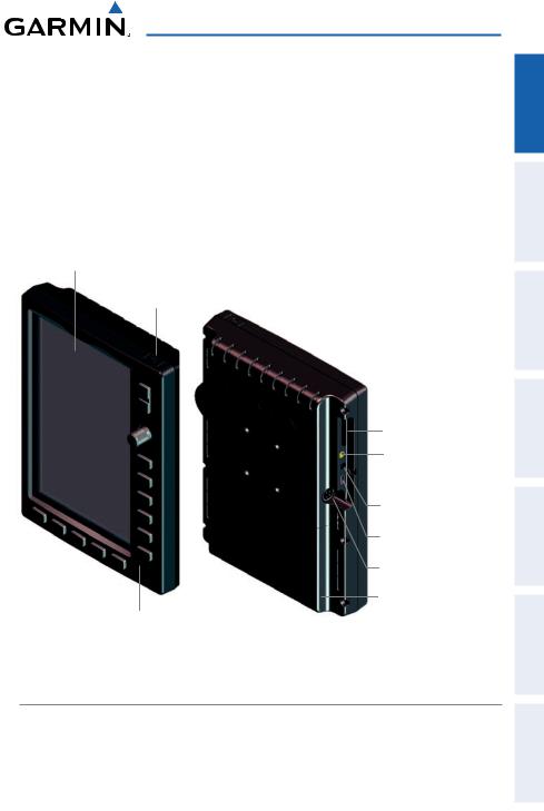
The GPSMAP 695/696 presents GPS-derived analog flight instrumentation, position, navigation, and hazard avoidance information to the pilot using a 7” Wide VGA (800x480) color display.
7” WVGA (800x480)
Color Display
Power Button
SD Card Slot
External GPS Antenna
Connector
Audio (Headphones/Line Out)
USB Connector
External Power/Serial Port
Connector
Battery Pack
Backlit Keypad
Unit Overview
Battery Care and Charging
Battery Warnings
If these guidelines are not followed, the internal Nickel Metal Hydride battery may experience a shortened life span or may present a risk of damage to the GPS unit, fire, chemical burn, electrolyte leak, and/or injury.
Appendices Features Additional Avoidance Hazard Planning Flight Navigation GPS Overview
Index
190-00919-00 Rev. D |
Garmin GPSMAP 695/696 Owner’s Manual |
1 |
|

Appendices Additional Features Hazard Avoidance Flight Planning GPS Navigation Overview
Index
Overview
•Contact your local waste disposal department to properly recycle/dispose of the unit/battery.
•Do not leave the unit exposed to a heat source or in a high temperature location, such as in the sun in an unattended aircraft on a hot day. To prevent damage, remove the unit from the aircraft or store it out of direct sunlight.
•Do not disassemble, puncture, damage, or incinerate the unit/battery.
•When storing the unit for a limited length of time (less than 30 days), store within the following temperature range: -68° to 122°F (-20° to 50°C). When storing the unit for an extended time, store within the following temperature range: -68° to
86°F (-20° to 30°C).
•Do not operate the unit outside of the following temperature range:-68° to 140°F
(-20° to 60°C).
•Keep the used battery away from children.
Additional User-replaceable Battery Warnings
•Do not use a sharp object to remove the battery.
•Do not recharge the battery out of the unit.
•Only replace with a Garmin Nickel Metal Hydride battery pack. Using another battery presents a risk of fire or explosion. To purchase a replacement battery, see your Garmin dealer or the Garmin Web site.
Additional Non-user-replaceable Battery Warnings
•Do not remove or attempt to remove the non-user-replaceable battery.
•When disposing of the unit, take it to a professional service, such as a waste electronics treatment facility, to have the battery removed and recycled.
2 |
Garmin GPSMAP 695/696 Owner’s Manual |
190-00919-00 Rev. D |
|

Overview
Inserting/Removing the Battery Pack
|
|
|
|
|
|
|
|
|
|
|
|
|
Battery |
Locks (In) |
|
Battery |
Locks (Out) |
|
|
Inserting the Battery Pack
Charging the Battery Pack
Plug the unit into a 12-Volt or 24-Volt connector to charge. The unit can be used while it is charging. Charge the unit within the following temperature range: 32° to
104°F (0° to 40°C).
Charging the unit’s battery pack:
1)Align the notches on the unit with the vehicle power cable plug.
2)Push the plug into the external power connector until fully seated.
3)Plug the power cable into the aircraft power outlet (cigarette lighter receptacle).
4)Route the power cable so that it does not interfere with aircraft operation.
The unit begins charging as soon as external power is applied. When the unit in Charge Mode it reduces the draw on the aircraft’s battery.
Using charge mode
Applying external power to the GPSMAP 695/696 automatically turns on the unit for full operation. If the battery is present and needs to be charged, the external power source charges the battery while the unit is in use.
If you do not want to use the unit, but you would like to charge the battery, you can put the unit into Charge Mode. Connect the unit to an external power supply. Press and hold the POWER Button. Instead of completely turning off, the unit now goes into Charge Mode.
Appendices Features Additional Avoidance Hazard Planning Flight Navigation GPS Overview
Index
190-00919-00 Rev. D |
Garmin GPSMAP 695/696 Owner’s Manual |
3 |
|
Overview
Appendices Additional Features Hazard Avoidance Flight Planning GPS Navigation Overview
Index
NOTE: While in Charge Mode, the unit draws a current from the aircraft. To avoid discharging the aircraft’s battery, disconnect the external power cable from the unit when not in use for several days.
Turning the Unit On/Off
Press and hold the POWER Button to turn the unit on or off.
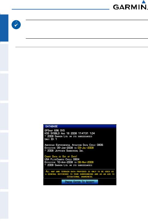
The first time the unit is turned on, the receiver must collect satellite data and establish its present location. To ensure proper initialization, the GPSMAP 695/696 is shipped from the factory in AutoLocate mode, which allows the receiver to “find itself” anywhere in the world.
During initialization,current database information is displayed. Database information includes valid operating dates, cycle number, and database type. When this information has been reviewed for currency (to ensure that no databases have expired), the pilot is prompted to continue.
Pressing the ENT Key acknowledges this information, and the MAP Page is displayed.
Database Initialization
4 |
Garmin GPSMAP 695/696 Owner’s Manual |
190-00919-00 Rev. D |
|
Overview
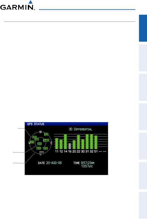
GPS Receiver Status
The receiver status field on the INFO Page displays one of the following conditions:
•Autolocate—Receiver is looking for any satellite whose almanac has been collected, which can take up to 5 minutes
•Searching the Sky—Receiver is looking for satellites
•Acquiring Satellites—Receiver is looking for and collecting data from satellites visible at its last known or initialized location, but has not acquired a fix
•2D GPS Location—At least three satellites have been acquired and a twodimensional location fix has been calculated. “2D Differential” appears when you are receiving DGPS corrections in 2D mode
•3D GPS Location—At least four satellites have been acquired and a threedimensional fix has been calculated. “3D Differential” appears when you are receiving DGPS corrections in 3D mode
•Lost Satellite Reception—the receiver is no longer tracking enough satellites for a
2D or 3D fix
|
|
|
|
|
|
|
|
|
|
|
|
||
|
Constellation |
|
|
|
|
|
|
|
|
||||
|
|
|
|
Receiver Status |
|||||||||
|
|
Diagram |
|
|
|
|
|
|
|
||||
|
|
|
|
|
|
|
|
|
|
|
|
|
|
|
|
|
|
|
|
|
|
|
|
|
|
|
|
|
|
|
|
|
|
|
|
|
|
|
Signal |
||
PRN Number |
|
|
|
|
|
|
|
Strength Bar |
|
||||
|
|
|
|
|
|||||||||
|
|
|
|
|
|
|
|
|
|
|
|
||
|
|
|
|
|
|
|
|
|
|
|
|
|
|
|
|
|
|
|
|
|
|
|
|
|
|
|
|
|
45° Above |
|
|
|
|
|
|
|
|
||||
|
|
|
|
|
|
PRN Number |
|||||||
|
|
|
|
|
|
||||||||
|
|
Horizon |
|
|
|
|
|
|
|
|
|
||
|
|
|
|
|
|
|
|
|
|
|
|
|
|
|
|
|
|
|
|
|
|
|
|
|
|
|
|
|
|
Horizon |
|
|
|
|
|
|
|
|
|||
|
|
|
|
|
|
GPS Status (Info Page) |
|||||||
Appendices Features Additional Avoidance Hazard Planning Flight Navigation GPS Overview
Index
190-00919-00 Rev. D |
Garmin GPSMAP 695/696 Owner’s Manual |
5 |
|

Appendices Additional Features Hazard Avoidance Flight Planning GPS Navigation Overview
Index
Overview
Acquiring Satellites
When the receiver is in the process of acquiring enough satellite signals for navigation, the receiver uses satellite orbital data (collected continuously from the satellites) and last known position to determine the satellites that should be in view.
‘Acquiring Satellites’ is indicated as the solution until a sufficient number of satellites have been acquired for computing a solution.
When the receiver is in the process of acquiring a 3D differential GPS solution, ‘3D
GPS Location’ is indicated as the solution until the 3D differential fix has finished acquisition.
Satellite Information
Satellites currently in view are shown at their respective positions on a satellite constellation diagram. The outer circle of the constellation diagram represents the horizon, the inner circle represents 45° above the horizon, and the center point shows the position directly overhead. Each satellite is represented by a square containing the
Pseudo-Random Noise (PRN) number (i.e., satellite identification number).
The INFO Page can be helpful in troubleshooting weak (or missing) signal levels due to poor satellite coverage or installation problems. As the GPS receiver locks onto satellites, a signal strength bar is displayed for each satellite in view, with the appropriate satellite PRN number (01-32 or 33-64 for WAAS) below each bar. The progress of satellite acquisition is shown in three stages, as indicated by signal bar appearance:
-No bar—Receiver is looking for the indicated satellite
-Gray bar—Receiver has collected the necessary data and the satellite signal can be used
-Green bar—Satellite is being used for the GPS solution
6 |
Garmin GPSMAP 695/696 Owner’s Manual |
190-00919-00 Rev. D |
|
Overview
1.2 GPSMAP 695/696 Controls
The GPSMAP 695/696 controls have been designed to simplify operation of the system and minimize workload and the time required to access sophisticated functionality.
1
2
3
4
5
6
7
8
9
|
|
|
|
|
|
|
|
|
|
|
|
|
|
|
|
|
|
|
|
10 |
|
|
|
|
|
|
|
Controls |
|||
1 |
Power |
Press and hold to turn the unit on or off |
|||||
|
Button |
With the unit on, press to adjust the backlight and volume |
|||||
2 |
RNG Key |
Press to increase or decrease the viewing range of the map |
|||||
3 |
FMS |
Press the FMS Joystick to toggle input focus between user |
|||||
|
Joystick |
interaction with the current page and the page navigation bar |
|||||
|
|
Turn the FMS Joystick clockwise to access a dropdown menu |
|||||
Turn the FMS Joystick to change the selected value within the highlighted field
Move the FMS Joystick to highlight fields or move the map pointer when interacting with the page
Appendices Features Additional Avoidance Hazard Planning Flight Navigation GPS Overview
Index
190-00919-00 Rev. D |
Garmin GPSMAP 695/696 Owner’s Manual |
7 |
|

Appendices Additional Features Hazard Avoidance Flight Planning GPS Navigation Overview
Index
Overview
4 |
ENT Key |
Press to confirm menu selection or data entry |
|
|
Press to acknowledge messages |
|
|
Press and hold to mark a waypoint |
5 |
CLR Key |
Press to cancel an entry, revert to the previous value in a data entry |
|
|
field or remove menus |
|
|
Press and hold to return to the default page |
6 |
MENU Key |
Press once to view the Page Menu |
|
|
Press twice to view the Main Menu |
|
|
Press a third time to clear the Main Menu |
7 |
FPL Key |
Press to display the Flight Plan Page |
|
|
Press a second time to remove the Flight Plan Page |
8 |
Direct-To |
Press to activate the Direct-To function, enter a destination |
|
Key |
waypoint and establish a direct course to the selected destination |
9 |
NRST Key |
Press to display the Nearest Page for viewing the nearest airports, |
|
|
intersections, NDBs,VORs, waypoints, frequencies, and airspaces |
10Softkey Press to select the softkey shown above the bezel key on the unit
Selection Keys
Softkey Function
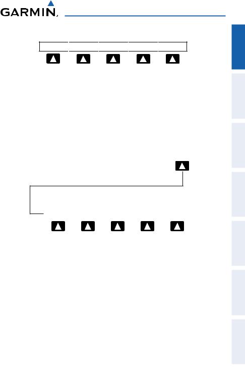
The softkeys are located along the bottom of the display. The softkeys shown depend on the softkey level or page being displayed. The bezel keys below the softkeys can be used to select the appropriate softkey. When a softkey is selected, its color undergoes a momentary change to black text on blue background then automatically switches to black text on gray background and remains this way until it is turned off, at which time it reverts to white text on black background. When a softkey function is disabled, the softkey label is subdued (dimmed).
Softkeys revert to the previous level after 45 seconds of inactivity.
8 |
Garmin GPSMAP 695/696 Owner’s Manual |
190-00919-00 Rev. D |
|

Overview
Softkey
On
Softkey Names (Displayed)
Bezel Mounted
Softkeys (Press)
Softkeys (WPT Page)
MAP Page Softkeys
MAP |
|
TERRAIN |
|
WEATHER |
|
|
|
PANEL |
• MAP |
Enables second-level Map Page softkeys |
||
TERRAIN |
Displays/removes terrain awareness information |
||
WEATHER |
Displays/removes weather information |
||
PANEL |
Displays/removes the Panel |
||
|
|
|
|
|
|
MAP |
|
Press the BACK Softkey to return to the top-level softkeys.
VFR MAP |
|
IFR MAP |
|
TOPO |
|
SAT VIEW |
|
BACK |
|
|
|
|
|
|
|
|
|
|
|
VFR MAP |
|
IFR MAP |
|
LOW AWY |
HIGH AWY |
BACK |
|
||
Appendices Features Additional Avoidance Hazard Planning Flight Navigation GPS Overview
Index
190-00919-00 Rev. D |
Garmin GPSMAP 695/696 Owner’s Manual |
9 |
|
Appendices Additional Features Hazard Avoidance Flight Planning GPS Navigation Overview
Index
Overview
VFR MAP Softkey selected
IFR MAP |
|
Displays IFR map information and softkeys |
||||||||
TOPO |
|
Displays/removes topographical terrain shading |
||||||||
SAT VIEW |
|
Displays/removes satellite imagery (above 20nm scale) |
||||||||
BACK |
|
Returns to top-level softkeys |
||||||||
IFR MAP Softkey selected |
|
|
|
|
|
|
|
|||
VFR MAP |
|
Displays VFR map information and softkeys |
||||||||
LOW AWY |
|
Low Altitude (Victor) Airways displayed |
||||||||
HIGH AWY |
|
High Altitude Airways (Jet Routes) displayed |
||||||||
BACK |
|
Returns to top-level softkeys |
||||||||
Waypoint Page Softkeys |
||||||||||
|
|
|
|
|
|
|
|
|
|
|
|
INFO |
|
CHART |
|
AOPA |
|
WEATHER |
|
|
|
INFO |
Displays waypoint information |
CHART |
Displays optional FliteCharts |
AOPA |
Displays AOPA information |
WEATHER |
Displays METAR and TAF text |
Weather Page Softkeys (GPSMAP 696 ONLY)
PAN MAP |
|
|
|
ANIMATE |
|
INFO |
|
LEGEND |
PAN MAP |
Activates the map pointer for panning the map |
ANIMATE |
Animates NEXRAD weather |
INFO |
Displays XM Information |
LEGEND |
Displays weather legends |
10 |
Garmin GPSMAP 695/696 Owner’s Manual |
190-00919-00 Rev. D |
|
Overview
XM Audio Page Softkeys (GPSMAP 696 Only)
INFO 
 CATEGORY
 CHANNEL
 FAVORITE
 VOLUME
INFO |
Displays XM Information |
|
CATEGORY |
Highlights the Category field |
|
CHANNEL |
Highlights the Channels field |
|
FAVORITE |
Displays a list of favorite channels |
|
• VOLUME |
Enables second-level VOLUME softkeys. |
|
|
Press and hold to toggle Mute on and off. |
|
|
|
|
|
|
VOLUME |
Press the BACK Softkey to return to the top-level softkeys.
|
|
VOL - |
|
VOL + |
|
MUTE |
|
BACK |
VOL - |
Decreases XM audio volume |
VOL + |
Increases XM audio volume |
MUTE |
Toggles XM audio on/off |
BACK |
Returns to top-level softkeys |
Appendices Features Additional Avoidance Hazard Planning Flight Navigation GPS Overview
Index
190-00919-00 Rev. D |
Garmin GPSMAP 695/696 Owner’s Manual |
11 |
|

Appendices Additional Features Hazard Avoidance Flight Planning GPS Navigation Overview
Index
Overview
Menus
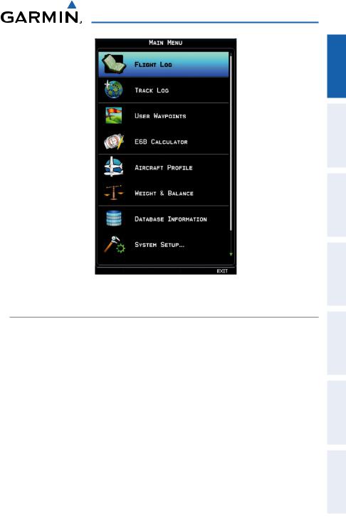
The GPSMAP 695/696 has a dedicated MENU Key that when pressed once displays a context-sensitive list of options for the page (Page Menu), and when pressed twice displays the Main Menu.
The Page Menu allows the user to access additional features or make settings changes which specifically relate to the currently displayed window/page. Menus display ‘No Options’ when there are no options for the window/page selected.
Navigating the Page Menu:
1)Press the MENU Key once to display the Page Menu.
2)Turn or move the FMS Joystick to scroll through a list of available options (a scroll bar always appears to the right of the window/box when the option list is longer than the window/box).
3)Press the ENT Key to select the desired option.
4)Press the FMS Joystick, the CLR Key, or the MENU Key twice to remove the menu and cancel the operation.
Page Menu (No Options) |
Terrain (TER) Page Menu |
Navigating the Main Menu:
1)Press the MENU Key twice to display the Main Menu.
2)Turn or move the FMS Joystick to scroll through a list of available options (a scroll bar always appears to the right of the window/box when the option list is longer than the window/box).
3)Press the ENT Key to select the desired option.
4)Press the FMS Joystick, the CLR Key, the EXIT Softkey, or the MENU Key to remove the menu and cancel the operation.
12 |
Garmin GPSMAP 695/696 Owner’s Manual |
190-00919-00 Rev. D |
|
Overview
Main Menu
Data Entry
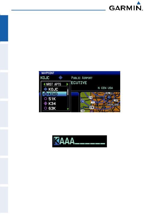
The FMS Joystick can be used for directly entering alphanumeric data into the GPSMAP 695/696. In some instances, such as when entering an identifier, the GPSMAP 695/696 tries to predict the desired identifier based on the characters being entered. In this case, if the desired identifier appears, use the ENT Key to confirm the entry without entering the rest of the identifier manually. This can save the pilot from having to enter all the characters of the identifier.
Besides character-by-character data entry, the system also provides a shortcut for entering waypoint identifiers. When the cursor is on a field awaiting entry of a waypoint identifier, turning the FMS Joystick counter-clockwise accesses a menu with three different lists of identifiers for quick selections:recent waypoints (RECENTWPTS), nearest airports (NRST APTS), and flight plan waypoints (FPL WPTS). The GPSMAP 695/696 automatically fills in the identifier, facility and city fields with the information for the selected waypoint.
Appendices Features Additional Avoidance Hazard Planning Flight Navigation GPS Overview
Index
190-00919-00 Rev. D |
Garmin GPSMAP 695/696 Owner’s Manual |
13 |
|
Appendices Additional Features Hazard Avoidance Flight Planning GPS Navigation Overview
Index
Overview
Using the FMS Joystick to enter data:
1)Press the FMS Joystick to activate the cursor.
2)Move the FMS Joystick to highlight the desired field.
3)Begin entering data.
a)To quickly enter a waypoint identifier, turn the FMS Joystick counterclockwise to display a list of recent waypoints (RECENT WPTS), nearest airports (NRST APTS) or flight plan waypoints (FPL WPTS).
b)Move the FMS Joystick to highlight the desired waypoint from the list and press the ENT Key.
Waypoint Entry (Waypoint Page)
Or:
a) Turn the FMS Joystick to select a character for the first placeholder.
Data Entry
Turning the FMS Joystick clockwise scrolls through the alphabet (where appropriate) toward the letter Z, starting in the middle at K (US only), and the digits zero through nine. Turning the FMS Joystick counter-clockwise scrolls in the opposite direction.
b)Use the FMS Joystick to move the cursor to the next placeholder in the field.
c)Repeat, turning the FMS Joystick to select a character and using the FMS Joystick to move the cursor, until the fields are complete.
d)Press the ENT Key to confirm entry.
4)Press the FMS Joystick or the CLR Key to cancel data entry (the field reverts back to its previous information).
14 |
Garmin GPSMAP 695/696 Owner’s Manual |
190-00919-00 Rev. D |
|

Overview
Pages
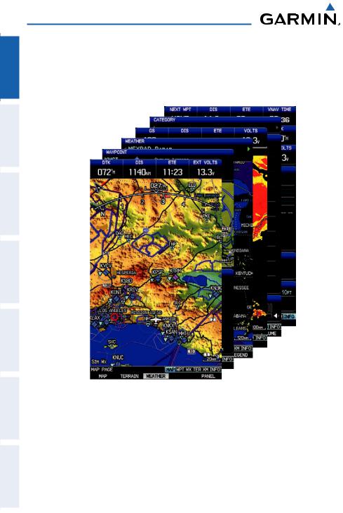
NOTE: The Weather (WX) Page and (XM) Audio Page are only available with the GPSMAP 696.
The pages are linked together in a series that you can cycle through using the FMS Joystick. A page navigation bar is displayed in the lower portion of each page, directly above the softkey bar. The right side of the page navigation bar shows a list of abbreviated names for each of the main pages, and the left side shows the name of the active page.
Press the FMS Joystick to toggle input focus between the page navigation bar and interaction with the current page (i.e., turning the cursor on/off).
|
Selected Page |
|
|
Active Page Title |
|
Input Focus on Navigation Bar |
|
|
|||
|
|
(Page Cursor Off) |
|
|
|
|
|
|
|
Input Focus on Current Page |
|
|
|
|
(Page Cursor On) |
There are up to six main pages that can be navigated using the FMS Joystick.
Selecting a Main Page using the FMS Joystick:
1)If necessary press the FMS Joystick to begin interaction with the Navigation Bar.
2)Turn the FMS Joystick until the desired page is selected (MAP, WPT, WX,
TER, XM, INFO).
Appendices Features Additional Avoidance Hazard Planning Flight Navigation GPS Overview
Index
190-00919-00 Rev. D |
Garmin GPSMAP 695/696 Owner’s Manual |
15 |
|
Overview
Appendices Additional Features Hazard Avoidance Flight Planning GPS Navigation Overview
Index
• Main Pages |
|
Map Page (MAP) |
Terrain Page (TER) |
Waypoint Page (WPT) |
XM Audio Page (XM) (optional) |
Weather Page (WX) (optional) |
Info Page (INFO) |
16 |
Garmin GPSMAP 695/696 Owner’s Manual |
190-00919-00 Rev. D |
|
 Loading...