


INA-N033R
EN
DE
FR
IT
ES
SE
NL
DK
SMART MAP PRO
Euro Multi Map
for Direction Guidance
Carte Européenne Détaillée Pour Guidage Dynamique
MANUAL DE OPERACIÓN
Lea este manual antes de utilizar este disco.
GEBRUIKSAANWIJZING
Lees de gebruiksaanwijzing zorgvuldig door
alvorens u de disk in gebruik neemt.
ANVÄNDARHANDLEDNING
Läs igenom handledningen innan du
använder den här skivan.
BRUGERVEJLEDNING
Læs venligst denne vejledning, for du tager
denne DVD i brug.
NVD-T003
Prog. Ver. T3.00
Database Ver. 3.00
R
OWNER'S MANUAL
Please read before using this disc.
BEDIENUNGSANLEITUNG
Lesen Sie diese Bedienungsanleitung bitte vor
Gebrauch der Disc.
MODE D'EMPLOI
Veuillez lire avant d'utiliser ce disque.
ISTRUZIONI PER L'USO
Si prega di leggere prima di utilizzare il disco.

2-EN
LL
LL
L The map database is designed to provide you with route
suggestions, it does not take account of the relative
safety of a suggested route, or of factors which may
affect the time required to reach your destination. The
database does not reflect road closures or construction,
road characteristics (i.e. type of road surface, slope or
grade, weight or height restrictions, etc.), traffic
congestion, weather conditions, or any other factors
which may affect the safety or timing of your driving
experience. Use your personal judgment if the
navigation system is unable to provide you with an
alternate route.
LL
LL
L There may be situations where the navigation system
may display the vehicle's location erroneously. Use
your own driving judgment in this situation, taking into
account of current driving conditions. Please be aware
that in this situation, the navigation system should
correct the vehicle's position automatically; however,
there may be times where you may have to correct the
position yourself. If this is the case, stop the vehicle in
a safe and legal manner and location before attempting
operation.
LL
LL
L Make certain that the volume level of the main unit is
set to a level which still allows you to hear outside
traffic and emergency vehicles. Driving while unable to
hear outside sounds could cause an accident.
LL
LL
L Please make certain that any other person who intends
on using the navigation system reads these precautions
and the following instructions carefully.
LL
LL
L If there is anything in the manual which you do not
understand, or are uncertain about the operation of the
navigation system, please contact an authorized Alpine
representative before using the navigation system.
Precautions
Important Information, Please Read
Carefully Before Using This Product.
This product is intended to safely provide turn by
turn instruction to get you to a desired destination.
Please read the following precautions to ensure
that you use your navigation system correctly.
LL
LL
L This product is not a substitute for your personal
judgment. Any route suggestions made by the
navigation system may never supersede any local traffic
regulations or your personal judgment and/or
knowledge of safe driving practices. Do not follow
route suggestions if the navigation system instructs you
to perform an unsafe or illegal maneuver, places you in
an unsafe situation, or routes you into an area which
you consider unsafe.
LL
LL
L Glance at the screen only when necessary and safe to
do so. If prolonged viewing of the screen is necessary,
stop the vehicle in a safe and legal manner and
location.
LL
LL
L Do not input destinations, change settings, or access
any functions requiring a prolonged view of the screen
and/or remote control while you are driving. Stop the
vehicle in a safe and legal manner and location before
attempting to access the system.
LL
LL
L Do not use the navigation system to route you to
emergency services. Not all locations of emergency
service providers such as police and fire stations,
hospitals, and clinics are contained in the database.
Please use your own judgment and your ability to ask
for directions in these situations.
LL
LL
L The map database contained within the media (DVD
ROM) in which it is stored is the most recent map data
available at the time of production. Because of changes
in streets and neighbourhoods, there may be situations
where the navigation system may not be able to route
you to your desired destination. In these cases, use your
own personal judgment.
ENGLISH

3-EN
WARNING
This symbol means important instructions. Failure
to heed them can result in serious injury or death.
DO NOT DISASSEMBLE OR ALTER.
Doing so may result in an accident, fire or electric shock.
KEEP SMALL OBJECTS SUCH AS BATTERIES OUT OF THE
REACH OF CHILDREN.
Swallowing them may result in serious injury. If swallowed,
consult a physician immediately.
DO NOT OPERATE ANY FUNCTION THAT TAKES YOUR
ATTENTION AWAY FROM SAFELY DRIVING YOUR
VEHICLE.
Any function that requires your prolonged attention should only
be performed after coming to a complete stop. Always stop the
vehicle in a safe location before performing these functions.
Failure to do so may result in an accident.
KEEP THE VOLUME AT A LEVEL WHERE YOU CAN STILL
HEAR OUTSIDE NOISE WHILE DRIVING.
Failure to do so may result in an accident.
DO NOT FOLLOW ROUTE SUGGESTIONS IF THE
NAVIGATION SYSTEM INSTRUCTS YOU TO PERFORM AN
UNSAFE OR ILLEGAL MANEUVER, OR PLACES YOU IN AN
UNSAFE SITUATION OR AREA.
This product is not a substitute for your personal judgment. Any
route suggestions by this system should never supersede any local
traffic regulations or your personal judgment or knowledge of
safe driving practice.
CAUTION
This symbol means important instructions. Failure
to heed them can result in injury or material
property damage.
HALT USE IMMEDIATELY IF A PROBLEM APPEARS.
Failure to do so may cause personal injury or damage to the
product. Return it to your authorized Alpine dealer or the nearest
Alpine Service Centre for repairing.
KEEP FINGERS AWAY WHILE THE MOTORIZED FRONT
PANEL OR MOVING MONITOR IS IN MOTION.
Failure to do so may result in personal injury or damage to the
product.
Tip
This indicates supplementary explanation of operation
of the system.
Points to Observe for Safe Usage
a Read the manuals for this disc and the system
components carefully before using your navigation
system. They contain instructions on how to use
the system in a safe and effective manner. Alpine
cannot be responsible for problems resulting from
failure to observe the instructions in these
manuals.
a This manual uses various pictorial displays to
show you how to use this product safely and to
alert you to potential dangers resulting from
improper connections and operation. Following
are the meanings of these pictorial displays. It is
important to fully understand the meanings of
these pictorial displays in order to use this manual
and the system properly.
USE THIS PRODUCT FOR MOBILE 12V APPLICATIONS.
Use for other than its designed application may result in fire,
electric shock or other injury.
DO NOT PLACE HANDS, FINGERS OR FOREIGN OBJECTS
IN INSERTION SLOTS OR GAPS.
Doing so may result in personal injury or damage to the product.

4-EN
User Agreement
In using this DVD-ROM "SMART MAP PRO"
(hereinafter referred to as "Disk"), as part of the
Aisin AW Co., Ltd. ("Aisin AW") and Navigation
Technologies Corporation ("NavTech") Database
(hereinafter referred to as "Database"), you are
bound by the terms and conditions set forth below.
By breaking the seal on this package, and using
your copy of the Database and Disk, you have
demonstrated your agreement to the terms and
conditions of this Agreement. You should therefore,
make sure that you read and understand the
following provisions.
a The Disk and Database may not be copied,
duplicated, processed, or otherwise modified, in
whole or in part, without the express written
permission of Aisin AW, NavTech and Alpine
Electronics, Inc. ("Alpine").
a Neither the Disk nor the Database may be
transferred or sublicensed to any third party for
profit, rent or loan, or licensed for reuse in any
manners.
a The Disk and/or Database may not be
decompiled, reverse engineered or otherwise
disassembled, in whole or in part.
a The Disk and Database may not be used in a
network or by any other manner of simultaneous
use in multiple systems.
a The Disk and Database are intended solely for
personal use (or internal use where the end-user
business), or the consumer. The Disk and
Database are not to be used for commercial
purposes.
a Neither Aisin AW, Alpine nor NavTech guarantees
to the customer that the functions included in the
Disk and Database meet a specific objective of
user.
a Neither Aisin AW, Alpine nor NavTech shall be
responsible for any damages caused by the use
of the Disk and/or Database to the actual user
and to any third party.
a The Warranty on the Disk and Database shall not
extend to an exchange or refund due to
misspelling, omission of letters, or any other
cosmetic discrepancy in layout found in Disk and/
or Database.
a The right to use the Disk and Database shall
expire either when the user destroys this software,
or when any of the terms for use is violated and
Aisin AW, Alpine and/or NavTech exercises the
option to revoke the license to use this software.
a The terms and conditions hereof apply to all
subsequent users and owners as well as to the
actual purchaser.
To Customers who use the INA-N033R
model
The Owner's Manual explains the function of the
map disc for the New-Version (Prog. Ver.3.00,
Database Ver.3.00). (The maps that are displayed
in this manual are used for the INA-N333R model.
Therefore, these maps may differ from those used
in the INA-N033R model.)
a Operating System Programme Rewriting
1) Insert the upgrade disc into your INA-N033R.
2) The operating system will automatically be
rewritten.
a RDS-TMC is available if the programme is
rewritten from Prog. Ver.1.00. (This can be
performed only if the optional RDS-TMC receiver
box TMC-001P is connected.)
Refer to "TMC Operation" (pages 21-23).
a The reception area for TMC will be expanded if
the programme is rewritten from Prog. Ver.2.30.
a The INA-N033R does not have a built-in TMC
tuner. The RDS-TMC receiver box TMC-001P can
be connected to utilize RDS-TMC. For details of
operation, please refer to the TMC-001P Owner's
Manual.
WARNING
a Operation of the system while driving is
dangerous. Users should stop vehicle before
operating the software.
a Road conditions and regulations take
precedence over information contained on the
display: observe actual traffic restrictions and
circumstances while driving.
a This software is designed for use exclusively
in the INA-N333R or INA-N033R. It cannot
and may not be used in conjunction with other
hardware.
Precautions

5-EN
Precautions
Important Information, Please Read
Carefully Before Using This Product ... 2
Points to Observe for Safe Usage ..........3
WARNING..................................................3
CAUTION ................................................... 3
User Agreement ....................................... 4
To Customers who use the INA-N033R
model ..................................................... 4
Contents.............................................5
Preface
Navigation Systems .......................................... 6
Navigation Terminology ................................... 8
Features ............................................................. 8
About the Guidance Display ............................. 9
Before Using The System
Setting the Navigation Mode .......................... 10
Setting the Language Mode ............................ 10
Registering Your Home ................................... 11
Searching For Destination
Selecting Countries ......................................... 12
Searching for Destination from Address......... 12
Searching for Point of Interest from
Category ...................................................... 14
Searching from Local Points........................... 15
Searching from Home/Previous Destination/
Memory Points ............................................ 15
Adding Waypoints on the Route ..................... 16
Setting the Display for the Destination Time
(INA-N333R only) ...................................... 16
Route Setting/Route Editing
Checking the Route by List ............................ 17
Researching ..................................................... 17
Changing the Searching Conditions ............... 17
Changing the Conditions of the Searched
Route ........................................................... 17
Deleting the Destination ................................. 18
Changing the Sequence of Waypoints ............ 18
Deleting Waypoints on the Route ................... 19
Drive Simulation ............................................. 19
Editing for Memory points
Changing the Name of a Memory Point or
Inputting a Phone Number .......................... 20
Deleting the Memory Points ........................... 20
TMC Operation
Automatic Seek Tuning (SEEK) for Receiving
TMC Stations (INA-N333R only) .............. 21
Displaying the Traffic Event Information
on Route ...................................................... 22
Displaying all Receiving Traffic event
Information .................................................. 22
Setting Dynamic Route Seek .......................... 23
Setting the RDS-TMC Voice Guidance to
Interrupt the Radio or CD, etc. .................... 23
Selecting TMC Reception (Only when TMC-
001P is connected) ....................................... 23
Setting the System
Setting the Anticipated Arrival Time .............. 24
Setting When Vehicle's Tyres have been
Changed ....................................................... 24
Updating the Present Vehicle Position ............ 25
Setting the Voice Guidance Volume ................ 25
Suspending/Restarting Voice Guidance .......... 26
Calling Up the Audio Source .......................... 26
Remote Control Operation
Operation on Remote Control RUE-4191
(optional) ..................................................... 27
Operation on Remote Control RUE-4135
(optional) ..................................................... 28
Reference
In Case of Difficulty ....................................... 29
If this Message Appears .................................. 30
Contents
Notes
• Due to continuous product improvement, specifications and
design are subject to change without notice.
• The displays shown in the photos in this manual may vary
slightly from the actual unit screen displays.
Traffic Information in the UK provided by
ITIS Holdings Plc.

6-EN
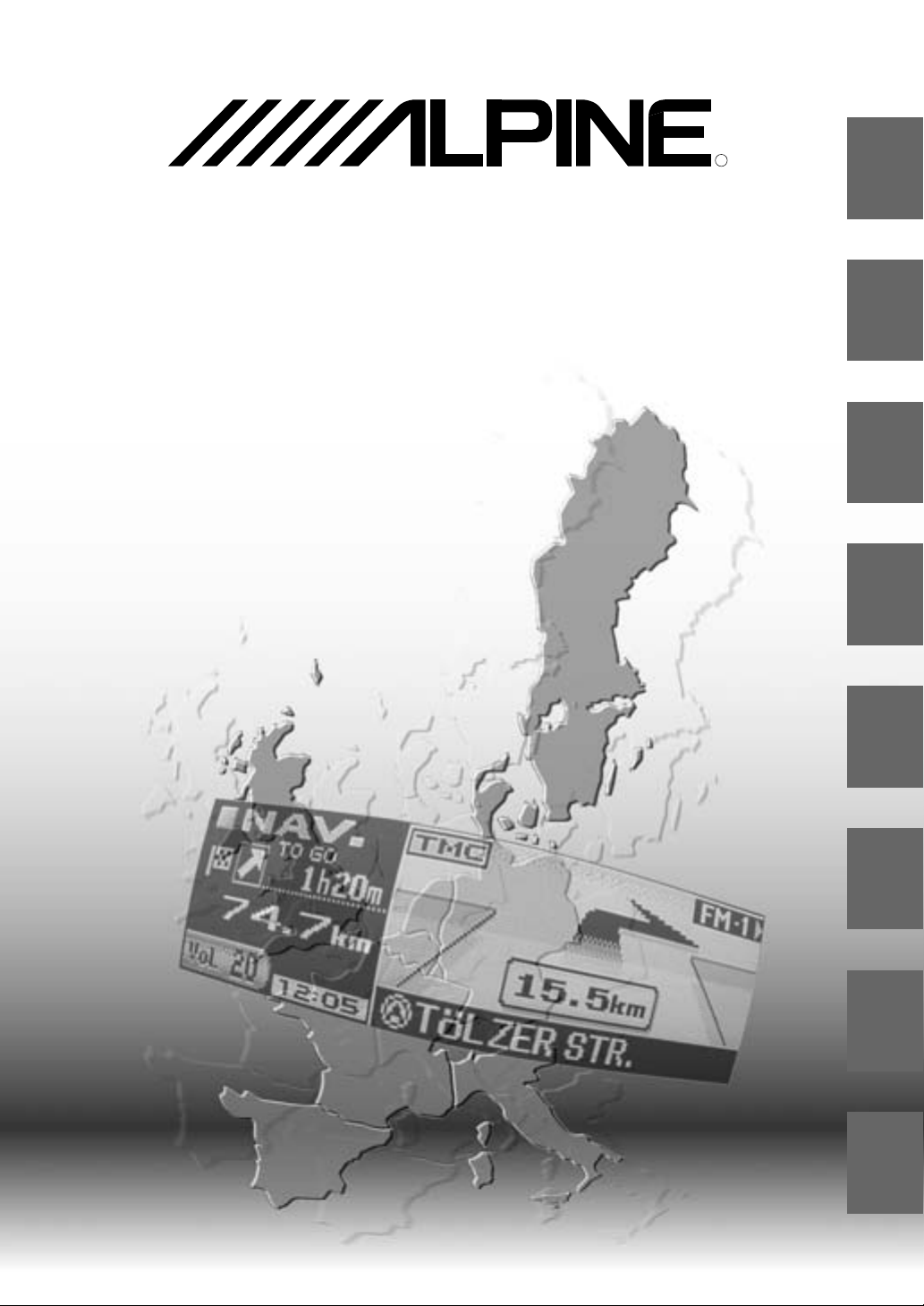
Navigation Systems
This navigation system uses three different sensing
devices to determine the present location and to track
the progress of the vehicle. These three devices are: a
GPS (Global Positioning System) receiver which
receives digital signals from the GPS satellites to
determine the current position of the vehicle, a
gyroscope which determines which direction the vehicle
turns, and a speedometer pulse sensor which
determine how far the vehicle has travelled. Because
this system incorporates a gyroscope and a speed
sensor, the system will be able to display the vehicle's
position and track the vehicle's progress even in areas
where the GPS signal may be blocked.
All map data is contained on a removable DVD ROM.
This system integrates this unique map database with
the sensing devices to automatically plot out a route
when a destination is entered. While driving, the
navigation system guides you along the route with
pictorial displays and verbal prompts.
GPS (Global Positioning System)
Delay time before the present vehicle's
position can be displayed
Determination of the present vehicle's position starts
when the ignition key is turned to the ACC or ON
positions and ends when the key is turned OFF. When
the key is first turned to the ACC or ON positions, there
is a slight delay of approximately one to two minutes
before the present vehicle's position can be displayed.
This system receives signals from 3 or more GPS
satellites (operated by the United States Department of
Defence) orbiting at an altitude of 21,000 kilometres and
measures the present car position using the same
principles as triangulation.
Preface
The error from the actual position of the
vehicle
When GPS signals can be received from 4 or more satellites, 3
dimensional positioning (the altitude, latitude, and longitude) of
the vehicle can be determined. In this case, the error from the
actual position of the vehicle is in the range of 100 to 655 feet
(30 to 200 meters). When GPS signals can only be received
from 3 satellites, only two dimensional positioning (latitude and
longitude) can be determined, resulting in a slightly increased
error. When GPS signals can only be received from less than
three satellites, positioning of the vehicle through GPS is not
possible. In addition to the inherent errors from GPS, the error
rate can also be increased if the United States Department of
Defense deliberately changes the accuracy rate.
Gyroscope
The gyroscope is a sensor that accurately measures the
angle by which the direction of a vehicle or other moving
body changes. Gyroscopes are used in inertial
navigation systems for airliners and ships. In this
navigation system, the gyroscope is used together with
the speed sensor, making it possible to display the
position of the vehicle even in locations where GPS
signals may be blocked.
7-EN
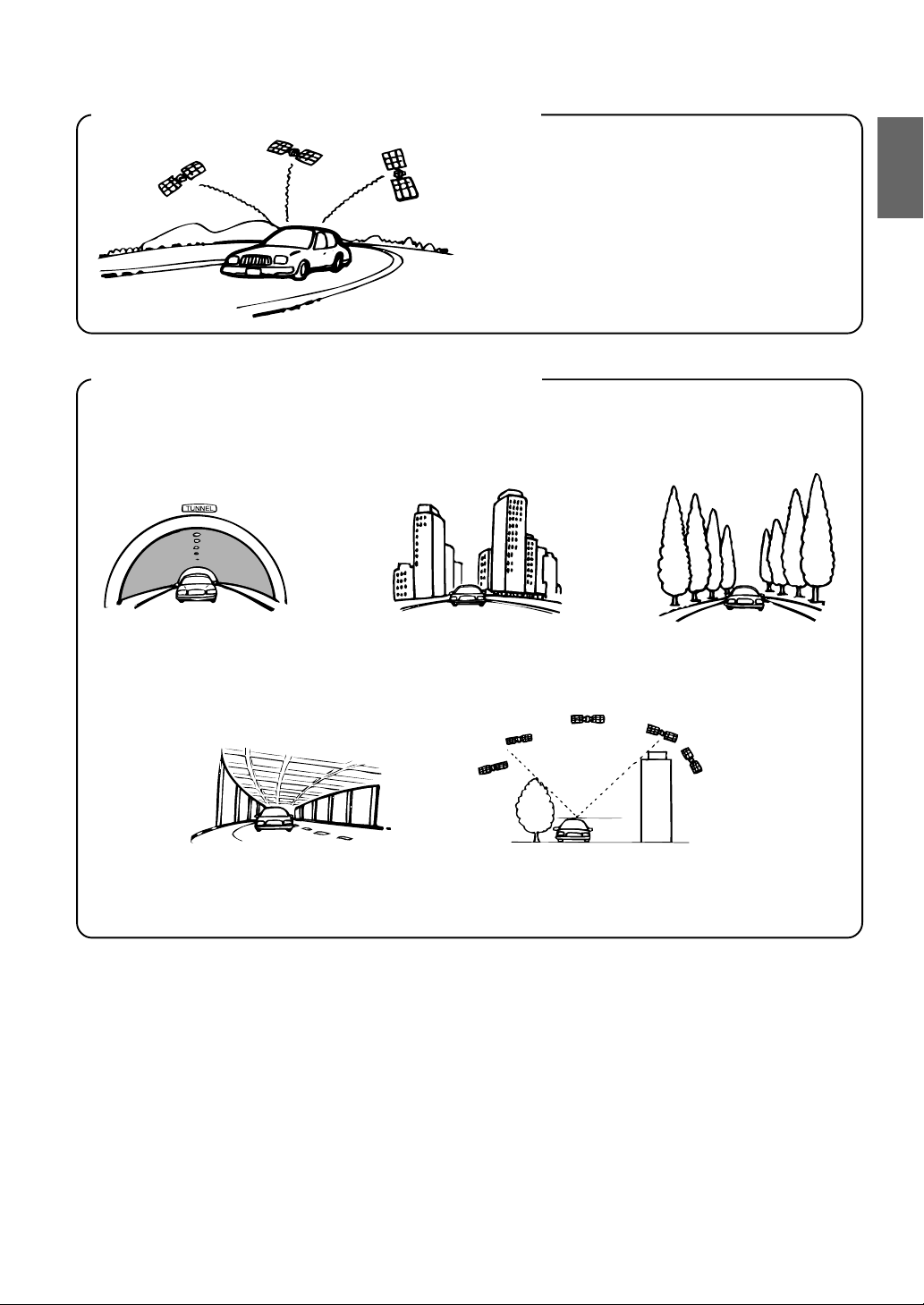
Locations where GPS signals are received easily
Locations where GPS signals cannot be received
In the following locations or conditions GPS signals cannot be received. However even in these locations, the gyroscope
and speed sensor will provide a substitute means of determining the vehicle's position and the system will be able to
continue to track the vehicle's progress along the route.
The optimum locations for receiving GPS signals
are locations that command a good view where
there are no tall buildings, trees, or other objects to
obstruct the signals.
In tunnels and indoor parking lots Locations surrounded by tall
buildings
Locations surrounded by tall
trees
On the bottom level of double-
decker motorways
When a GPS satellite is low on the horizon (angle below 10°),
obstructions sometimes make normal reception impossible

8-EN
Navigation Terminology
Navigation
When a destination is input, the navigation system
quickly calculates a route and guides you along the
route with arrow displays and voice prompts.
Present Vehicle Position
The navigation system integrates the GPS (Global
Positioning Satellite) signals received and the map
information stored on the DVD ROM to display the
position and direction of the vehicle. The system also
includes a gyroscope and a speed sensor that enable it
to display the present position even in locations where
the GPS signals may be blocked.
Map Matching
Since GPS navigation has an error of 100 – 655 feet (30
m – 200 m), the position of your vehicle may be
displayed off the road. Map matching automatically
corrects this error so that the position of your vehicle is
displayed on the road.
Route
When a destination is input, the navigation system
automatically calculates a route.
Road Preference Setting
You can set your preferred road on the route to the
destination for up to 2 places.
Memory Points
Locations you go to frequently can be stored into
memory. The system can store up to 50 points,
excluding your home.
Motorway-Preference Selection
When searching for routes with the navigation system,
you can switch between searching for routes that give
priority to motorways and those that give priority to
ordinary roads. When you specify motorway preference,
the navigation system automatically searches for a route
that gives priority to motorways and guides you along
that route.
Features
Advanced Real Junction View
When you are driving on a motorway where quick
decisions are required, you can display a detailed map
of the next junction in advance, and a 3-D view of the
appropriate lane along the recommended route.
Preface
Intersection Zoom
As you near intersections and cross points, the map
display automatically zooms in to show a more detailed
view that you will need.
Motorway Information Display
When you travel on motorways, the basic guidance
display (with an arrow) automatically shows the
distances to the next fuel station/restaurant/parking/
junction (except exit).
Three Types of Auto Route Searching
Simultaneously
You can choose the best route from three types of route
searching to your destination.
Turn List on the Route
After you have set the route, you can check the
sequence of waypoints, road names and distances
between points by displaying this list.
Setting Waypoints
You can set one or 2 waypoints to go through to your
destination.
Real Time Voice Guidance
Voice guidance informs you of the distance and direction
until your course changes, giving advice timed to match
road conditions.
The VOICE button lets you call up the voice guide when
needed by just pushing the button.
DVD-ROM covers All European Areas
All areas of Europe are covered by one disc.
Eight Languages selectable for the Voice
and Display Guidance
You can choose one of eight languages for the voice
route guidance and menu displays. (see the “Setting the
Language Mode” section, page 10.)
Built-in Gyroscope and Speed Sensors
The gyroscope for sensing direction and the speed
pulse sensor for detecting distance provide data which
allows the vehicle position and direction to be displayed
even in locations where the GPS signal cannot be
received such as between buildings or in tunnels.
TMC (Traffic Message Channel)
If there is TMC information, TMC stations can be
received by selecting a station on the built-in TMC tuner.
The optional RDS-TMC receiver box TMC-001P can
also be connected. (For the INA-N033R, only when
TMC-001P is connected.)
9-EN
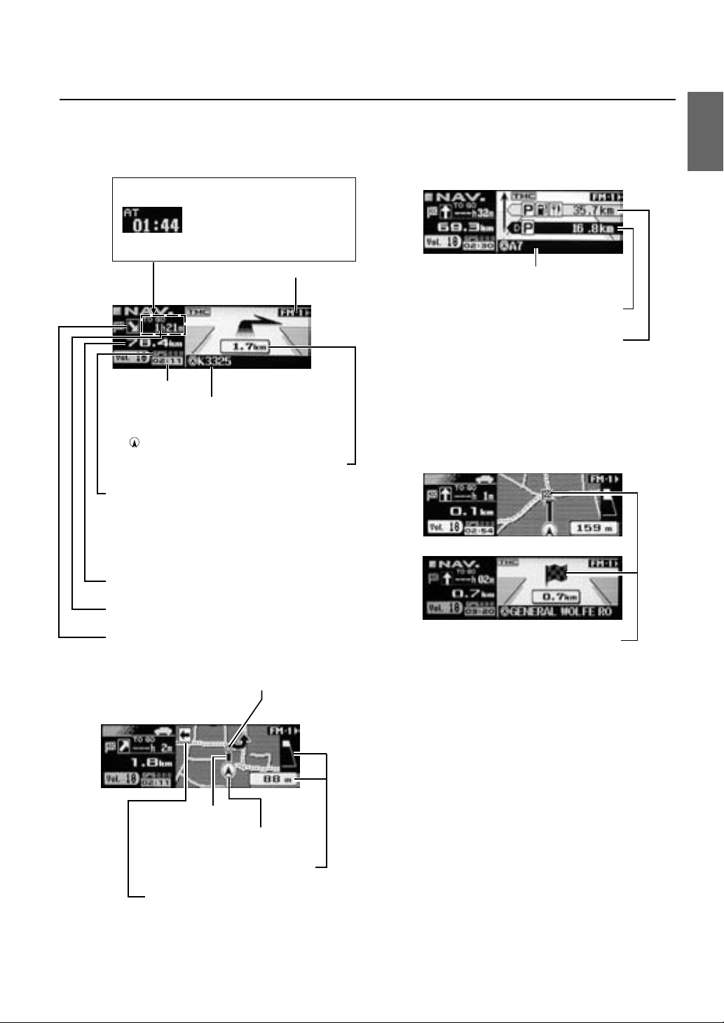
About the Guidance Display
While you are driving with the route guidance, the display screens are shown as follows.
(The maps that are displayed in this manual are used for the INA-N333R model. Therefore, these maps may differ from
those used in the INA-N033R model.)
Zoomed Intersection
Display
Guidance route
Turning point
Vehicle’s current position
Distance to the next turning point
Notes
About the left/right display indicators
• When you turn to right, the right indicator blinks for about 5
seconds, and then stays lit.
• When you turn to left, the left indicator blinks for about 5
seconds, and then stays lit.
• When the destination is near, the indicators blink on both
sides.
Basic Guidance Display for Motorways
Second parking area
Next parking area
Current vehicle position
Arrival Display
This icon appears when destination is near.
Sub display mode
Estimated remaining time before arrival
Direction to destination
Distance in a straight line to the destination
Current time
Current vehicle position
(The name of the current road you are on is
displayed. If no information is available, only the
(current vehicle position mark) is displayed.)
Distance to next maneuver
GPS reception sensitivity
77
77
7
77
77
7
77
77
7
: Three dimensional positioning
77
77
7
77
77
7
: Two dimensional positioning
77
77
7
: Positioning is being calculated
No positioning is displayed when GPS signals are
not received.
Direction to the second turning point
If "Arrival" is set in the "Setting the
Display for the Destination Time"
section (page 16), the screen is
displayed as shown on the left.
(This display and the settings apply
to the INA-N333R model only.)
Basic Guidance Display

10-EN
Before Using The System
Setting the Navigation Mode
1 Press SOURCE/POWER button to turn on the power.
2 Press the NAV. button.
Changing the Audio mode to Navigation mode.
The current vehicle position is displayed.
3 Press c button to open the display and then insert the
SMART MAP PRO disc.
4 Move the Flipper switch up or down to move the
cursor to the desired language and press the OK
button or MODE knob to execute the selection. (When
the system is used for the first time)
Note
For English, you can select the distance indications in either
miles(mile) or Kilometres(Km).
For other languages, only kilometres are used for the distance
indications.
5 Selected language is displayed.
An important message is displayed. Please read this
message after stopping the vehicle in a safe location.
Press the OK button. (You cannot carry out this
operation with the Enter button on the optional remote
control.)
6 The present vehicle position is displayed.
Note
Some operations (when displaying the navigation menu, etc.)
cannot be performed while the vehicle is in motion. In this case,
be sure to first stop your vehicle and apply the parking brake,
then perform the operation.
Setting the Language Mode
For the picture/voice guidance and texts, you can
choose one of 8 languages as follows.
a German (Deutsch) a Dutch (Nederlands)
a English (mile or km) a Spanish (Español)
a French (Français) a Swedish (Svensk)
a Italian (Italiano) a Danish (Dansk)
The guidance language can be changed whenever you
like by following the procedure below.
1 Press the MENU button to display "NAV. MENU."
2 Select "NAVI Setup" from "NAV. MENU" by moving the
Flipper switch up or down and press the OK button or
MODE knob to execute the selection.
3 Select "System Setup" from "NAVI Setup" by moving
the Flipper switch up or down.
Press the OK button or MODE knob to execute the
selection.
4 Select "Language" from "System Setup" by moving the
Flipper switch up or down.
Press the OK button or MODE knob to execute the
selection.
NAV. OK MODE
Flipper switch
MENU RTN
SOURCE/POWER
c
Number of received satellite signals
Explanations in this Owner's Manual are based mainly on
the INA-N333R model.
 Loading...