


Pub. 988-0147-383
www.lei-extras.com
MapCreate 6
Custom Mapping Software for GPS
Installation and Operation
Instructions

Copyright © 2004 LEI. All rights reserved.
No part of this manual may be copied, reproduced, republished, transmitted, distributed, downloaded or stored in any storage medium, for any purpose, without prior written consent of LEI. Any unauthorized commercial distribution of this manual is strictly prohibited.
MapCreate is a trademark of LEI.
 U.S. Points of Interest Data in this unit are by infoUSA,
  copyright 2001-2004, All Rights Reserved. infoUSA is a trademark of infoUSA, Inc.
U.S. eXitSource Database, copyright 2001-2003 Zenrin Co. Ltd. Exit Authority and eXitSource are trademarks of
Zenrin Co. Ltd.
Canadian mapping data 2003 by DMTI Spatial Inc.
European mapping data 2003 by Tele Atlas NV, the reference in digital mapping.
LEI Extras, Lowrance Electronics, or Eagle Electronics may find it necessary to change or end their policies, regulations and special offers at any time. They reserve the right to do so without notice. All screens in this manual are simulated.
For free owner's manuals and the most current information on this product, it's operation and accessories, visit the manufacturer's web sites:
www.lowrance.com www.eaglegps.com
To purchase Lowrance or Eagle accessories, visit our web site:
www.lei-extras.com
LEI
PO BOX 129
Catoosa, OK USA 74015
Printed in USA.
Table of Contents |
|
Sec. 1: Introduction................................................................... |
I |
Quick Start Reference ................................................................... |
2 |
How MapCreate Works: The Basics ............................................ |
6 |
File Formats & Functions ............................................................ |
7 |
Map Border File ........................................................................ |
7 |
Custom Map File....................................................................... |
7 |
Important Notes: File Encryption and Card Limits................ |
8 |
Important Notes About Cards and File Size ........................... |
9 |
GPS Data File ......................................................................... |
11 |
ASCII Text File ....................................................................... |
11 |
GPS Data Manager (GDM) File ............................................. |
12 |
Atlas File ................................................................................. |
12 |
GPS Unit Compatibility ......................................................... |
13 |
Mapping Detail: There's More Here Than Meets the Eye. ......... |
13 |
Find Highway Exit Services................................................... |
13 |
Find Points of Interest............................................................ |
14 |
Find an Address ...................................................................... |
14 |
How to Use this Manual: Typographical Conventions.............. |
15 |
Sec. 2: Installing MapCreate 6.3........................................... |
17 |
System Requirements............................................................. |
17 |
Installation Types ................................................................... |
17 |
Installing MapCreate.............................................................. |
18 |
Care of your MapCreate CDs ................................................. |
28 |
Starting MapCreate................................................................ |
28 |
Sec. 3: User's Guide ................................................................. |
31 |
Starting MapCreate.................................................................... |
31 |
The MapCreate Screen ............................................................... |
32 |
Closing MapCreate ................................................................. |
33 |
MapCreate Screen Components ............................................. |
33 |
Master Map Window............................................................... |
34 |
Main Menu .............................................................................. |
35 |
Toolbars ................................................................................... |
35 |
Create Map (Easy) Toolbar................................................. |
36 |
Create Map (Advanced) Toolbar......................................... |
37 |
File Toolbar ......................................................................... |
37 |
GPS Data Toolbar ............................................................... |
38 |
Map Navigation Toolbar ..................................................... |
39 |
Map Category Options Window ............................................. |
40 |
Waypoint List Window ........................................................... |
41 |
Icon List Window .................................................................... |
41 |
Route List Window.................................................................. |
42 |
Route Waypoint List Window................................................. |
42 |
i |
|
Trail List Window ................................................................... |
43 |
Moving around the Master Map................................................. |
44 |
Pan Arrows.............................................................................. |
44 |
Center Map.............................................................................. |
44 |
Zoom Area ............................................................................... |
45 |
Zoom in/Zoom Out................................................................... |
45 |
Zoom Range Window .............................................................. |
46 |
Creating Rectangle Map Borders............................................... |
47 |
Estimate Map Size (Optional) ................................................ |
48 |
Saving a Map Border File (Optional)..................................... |
48 |
Creating Corridor Map Borders ................................................. |
50 |
Edit Corridor Borders ............................................................. |
52 |
Creating and Saving a Custom Map.......................................... |
52 |
Creating a Waypoint................................................................... |
54 |
Creating an Icon ......................................................................... |
56 |
Creating a Route......................................................................... |
58 |
Saving a GPS Data File.............................................................. |
61 |
Moving GPS Data Files Between Computer and Unit.......... |
62 |
Creating a Corridor Map from a Route...................................... |
63 |
Creating a Route from a Trail.................................................... |
66 |
Appendix 1: MapCreate Command List.............................. |
69 |
Searching Help............................................................................ |
70 |
Appendix 2: Map Category List............................................ |
73 |
Appendix 3: MapCreate 6 Symbol Key................................ |
77 |
Appendix 4: Displaying Specialty Maps............................. |
81 |
IMS Fishing Hot Spots Maps ..................................................... |
82 |
Jeppesen Aviation Maps............................................................. |
83 |
Appendix 5: Planning Highway Routes.............................. |
87 |
Tips on Making Better Routes for Highway Navigation....... |
87 |
"High Resolution" vs. "Low Resolution" Routes .................... |
87 |
Index........................................................................................... |
91 |
LEI End User License Agreement ....................................... |
95 |
ii
Notes
iii
WARNING!
A CAREFUL NAVIGATOR NEVER RELIES ON ONLY ONE METHOD TO OBTAIN POSITION INFORMATION.
CAUTION
When showing navigation data to a position (waypoint), a GPS unit will show the shortest, most direct path to the waypoint. It provides navigation data to the waypoint regardless of obstructions. Therefore, the prudent navigator will not only take advantage of all available navigation tools when traveling to a waypoint, but will also visually check to make sure a clear, safe path to the waypoint is always available.
WARNING!
When a GPS unit is used in a vehicle, the vehicle operator is solely responsible for operating the vehicle in a safe manner. Vehicle operators must maintain full surveillance of all pertinent driving, boating or flying conditions at all times. An accident or collision resulting in damage to property, personal injury or death could occur if the operator of a GPS-equipped vehicle fails to pay full attention to travel conditions and vehicle operation while the vehicle is in motion.
iv
Section 1: Introduction
How this manual can get you into the field, fast!
Thanks for buying MapCreate , the custom mapping software for Lowrance and Eagle GPS units. This manual was written using MapCreate U.S.A. and MapCreate Canada versions 6.3. Beginning with version 6.3, all MapCreate packages work identically, but contain different mapping data.
We know you're eager to install the program and make some maps, but we have a favor to ask. Before you grab that CD, give us a moment to explain how our manual can help you get the best performance from our software. Our goal is to get you on the road, into the air, or out to the woods and water fast. Like you, we'd rather spend more time outdoors, and less time reading a manual!
That's why we designed this book so you don't have to read the whole thing from front to back for the information you want. You can skip around! If you know where to look, we've made it easy to find the tips you may need from time to time.
The manual has three main sections:
Section 1: Introduction contains the Quick Start Reference, which begins on page 2. We put it near the front of the book so you can turn to it quickly. Sec. 1 also includes background information on how MapCreate and its file formats work. To understand how to interpret our instruction text, be sure to see the Typographical Conventions segment on page 15. Don't miss the important notes on File Encryption and Card Limits on page 8.
Section 2: Installing MapCreate (on page 17) will help you get the program and the required LEI card reader correctly installed on your computer.
Section 3: User's Guide (on page 31) is the heart of our book. It introduces you to the MapCreate windows and toolbars. Sec. 3 contains easy-to-skim lessons on the program's main operations. These segments show you how to make highly customized maps and GPS information and get them into your GPS unit.
After you've gained some experience with the program, you may want to try some advanced features. That brings us to the Command Reference, which is available only in the MapCreate 6 Help file. It contains
— in alphabetical order — the more advanced command functions in MapCreate.
Each entry includes a summary box briefly telling what the command does and how to run it from the menu, toolbar or keyboard. Then, we've
1
included more tips and tricks so you can take advantage of all the power and performance MapCreate offers.
You can see an example of the Help file's Command Reference format in Appendix 1 at the back of this manual, on page 69. Appendix 1 contains the entry on the Help Command, which explains how to use Help.
In addition to the Command Reference, the Help file includes material from this manual's User's Guide segment. Just press the F1 key to launch Help. You can find facts fast by electronically searching the Help File for the word or phrase you want.
In our printed manual, we've included other general supplemental material as appendices in the back of the book. Check out the Table of Contents to see the topics contained in each appendix.
After you have the software and card reader installed, browse through the tutorials in Sec. 3 to get you going. Later, when you want to try something new or you have a question about a particular function, skim through the manual's table of contents or search the Help file's Command Reference to read what you need.
If you're an experienced computer user, you can probably install MapCreate and the card reader without the manual. But, if you need a little coaching, jump ahead to Sec. 2 and we'll walk you through the install step by step. (If that's not easy enough, just grab the nearest teenager and ask him or her to install it for you!)
If you've skipped ahead and already have MapCreate installed, check out the Quick Start Reference below. If you're the type of person who wants more background information before you start, turn to How Map Create Works on page 6, or begin learning about the MapCreate screen components at the start of Sec. 3.
Quick Start Reference
This 13-step summary will get you started with a simple map. It assumes you have already made a full, default installation of the program, and one of the CDs is in your CD-ROM drive. (Complete installation instructions begin in Sec. 2.) For more detailed explanations, read through the lessons in Sec. 3. Before you start, make sure your LEI MMC card reader is installed and working, and you know the reader's drive letter.
Many toolbar buttons are labeled, and an informative tool tip box pops up when you point to a button.
How to make and save a rectangle map
1.Start MapCreate by clicking the Windows START button and choosing your version of MAPCREATE from the menu.
2.Maneuver the Master Map so you can see the area you want to in-
2
clude in your map. Use the PAN ARROW buttons to move north, south, east or west. Use the ZOOM-IN and ZOOM-OUT (Z-IN or Z-OUT) buttons as needed to close in on or back away from the area you're viewing.
3.Click the DRAW MAP BORDERS button in the toolbar. Move the mouse pointer above and to the left of the desired area. Click, hold down the mouse button and drag diagonally down and to the right until the desired area is enclosed with the green border box. Then release the mouse button. You have just drawn a Map Border.
4.With the Map Border displayed, click the ESTIMATE CUSTOM MAP SIZE button, on the Create Map toolbar. After a moment it will tell you your map's file size. If it fits the card, click OK to clear the message and jump to step 5. If the map file is too large for the card, click OK to clear the message, then redraw your map border a little smaller. Click the DELETE MAP BORDER button, click on any green border line, then re-draw a smaller border box. Use the Estimate button to re-check the size until it is correct.
Click the OK button to clear the message box from your screen.
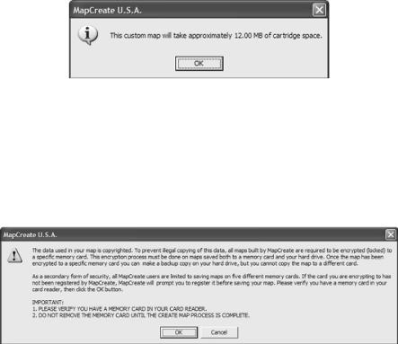
5.When your file is the right size, click the CREATE MAP button on the Create Map toolbar. The program displays a message about copyright and encryption.
6.If this is the first time you have tried to save a file to your memory card, MapCreate will need to register the card. Make sure you have a card in your card reader. Click OK to continue. (Clicking Cancel ends the process.) If you have already registered the card you are using, click OK and skip to step 11.
Read the message, and then click OK to continue.
3
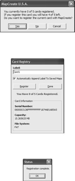
7. Another message box asks whether you want to register your current card or not. Click YES to continue the card registration process.
Click Yes to register your current memory card with MapCreate.
8. You can change the label on your memory card if you prefer. Delete the default name, "Card1," and enter the new name. Click REGISTER to continue.
Delete the default label, if you prefer, and enter a new name. Then click Register to continue.
9. Another message box tells you when your card has been registered. Click OK to continue.
Click OK to continue the create map process.
10. The Card Registry window appears again. Click DONE to save your map.
4
Click Done to complete the registry process.
NOTE:
If the AUTOMATICALLY APPEND LABEL TO SAVED MAPS box is selected (see
figure above), MapCreate will automatically add your card's label to the end of whatever name you give the file you are saving. Let's use the figure above as an example. If we name our map "Phoenix.lcm," MapCreate will automatically name the file "Phoenix_CARD1.lcm." To cancel this option, click the Automatically Append… box to remove the check mark.
11.A window shows the progress of your map build. When the map is built, MapCreate displays the SAVE AS dialog box. Type a file name for your Map File, and click SAVE. (MapCreate will save your new custom map to your memory card.)
12.After the program has saved the map to your card, the Save Progress box disappears. You can now close MapCreate and remove the card from the reader.
13.Follow the instructions in your GPS manual for loading the MMC or SD card into your unit. It will automatically read the map when the unit is turned on.
NOTE:
Custom maps and GPS data (waypoints, routes, trails, icons) are contained in two different file types. We describe their functions in the following segments on how the program works.
5
How MapCreate Works: the Basics
You'll be making maps faster if you understand the hoops MapCreate must jump through to cram a high-detail map into your GPS unit.
First of all, those CDs you just purchased contain a whole bunch of raw digital cartography data. There are several hundred files of digital mapping information containing lake shorelines, navigation aids, roads, rivers and all the other information that goes into our high-detail maps.
It takes some fancy formatting to fit the whole world onto a few compact discs. Your GPS unit can't read those raw files (called atlas files). Even if it could, no GPS unit or MultiMedia Card (MMC) has enough memory to hold that much information.
This is where MapCreate comes in. The program looks at all those raw atlas files, shuffles the different types of information together, and then places them onto your computer screen. That's what we call the Master Map, the main window in the MapCreate interface. By changing various options in MapCreate, you can control how much geographic detail is displayed on-screen in the Master Map.
It's a pretty cool electronic map, but your GPS can't read it in this form, either. This is where you come in. You move around the Master Map and locate the area or areas you want to make a detailed map of. Then, you grab the computer mouse and draw a map border around the region you want. (There are two or three fun ways to do this…we'll describe 'em in a few minutes.)
Now, this map border isn't really a map yet — it just defines or outlines the area you want to include in the final GPS-friendly map. If you wish, you can save the boundary you have drawn as a Map Border File.
MapCreate uses a map border like an electronic shopping list. The program looks at your border, grabs the appropriate raw atlas information, and then glues it all together as a custom map. Now you can save this data as a Custom Map File on an MMC (or SD card) and load it into your GPS unit. (If you like, you can backup the Map File by copying it from the MMC card to your computer's hard drive.)
GPS information — such as waypoints, routes or trails — is handled differently. You can click the mouse to set a waypoint or plan a route, then save that information as a GPS Data File. Just save it directly on or copy it to the MMC and this file is ready to load into your GPS unit. When your unit makes trails or waypoints in the field, that information is also saved as a GPS Data File. Your GPS unit can save the file to the MMC, which allows you to copy the GPS Data File back into your computer. Then you can open, edit and save it in MapCreate.
6
File Formats & Functions
Well, now you know what makes MapCreate tick. You may be ready to skip forward to where we explain how our text formatting makes the manual easy to skim. If that's the case, move on to "How to Use This Manual: Typographical Conventions" on page 15. But, if you want to pick up an extra tip or two, look over this segment describing the file formats and memory cards MapCreate works with.
Map Border File
This file defines the boundary of the raw cartography data that is extracted and converted to a GPS custom map, or Map File. The border file information is displayed on the computer's Master Map screen as either a green rectangle (rectangle map border) or a magenta polygon shape (corridor map border.) The file extension is *.lmp.
In MapCreate 6.3, you can draw a border, then build and save a map without saving the border. However, some MapCreate power users still like to save their borders as Map Border Files. That lets them make changes to a border or even combine different borders without drawing them from scratch each time. By default, MapCreate will first save a Map Border File to the C:\Program Files\LEI\MapCreate\Data folder, but if you prefer you can save it on your memory card. If you save elsewhere, MapCreate remembers that location the next time you save. Version 6.3 also stores map border information in each Map File. This lets you generate a border simply by opening an existing Map File, including maps built by previous versions of MapCreate 6.
A Map Border File can contain one or more different map border sets, and these border sets don't need to be next to each other on the map. For example, you can draw a rectangle border around one lake and then draw a second corridor border around another lake several miles away, and include both of those border sets into one Map Border File. There is no limit (other than space on your hard disk, MMC or SD card) on how many different border sets you can include in a Map Border File. You can open and edit a Map Border File and then save the file with the changes you made.
Custom Map File
This is the actual map format used by your GPS unit. MapCreate takes the borders you drew (or saved as a Map Border File), extracts that area's information from the raw atlas data, then converts it to a Custom Map File, often called a Map File for short. We call this conversion process "creating the map." The file extension is *.lcm.
By default, MapCreate will first save a Map File direct to your MMC memory card. If you prefer, you can save a Map File on your computer hard drive. When
7
hard drive space is available, many users like to archive Map Files in the
C:\Program Files\LEI\MapCreate\Data folder. This allows you to change maps on your card and reuse a map over and over without creating it each time. If you save a map to the Data folder, MapCreate will remember that location the next time you save a map, during the current work session. The next time you start MapCreate, map saves will default back to the MMC card.
You cannot make changes to a Map File once it has been created. If you want to make changes to a map, return to its original companion Map Border File or retrieve the map borders by opening the Map File (*.lcm). Make your changes to the border, then create a fresh Map File. You can delete the old one, or just save the new map over the old map.
Important Notes: File Encryption and Card Limits
We collect and purchase cartography data from several sources. Much of this data is copyrighted, and our data suppliers require that we protect our maps from illegal copying. One level of protection requires that you have a MapCreate CD in the disc drive each time you launch the program. We also encrypt Map Files, and limit the number of MMC or SD cards you can use to store maps.
Map File Encryption
All maps built by MapCreate are required to be encrypted (or locked) to a specific memory card. This encryption process must be done on maps saved both to a memory card and your hard drive. Once a map has been encrypted to a specific memory card, you can make a backup copy on your hard drive, but you cannot copy the map to a different card. (Well, you can copy it to another card, but your GPS unit won't recognize it. To work, the Map File must reside on the card it was encrypted to.)
Limited Number of Cards
All MapCreate users are limited to saving maps on a maximum of five different memory cards. MapCreate tracks the number and identity of your cards by "registering" each card with the program. The software needed to register cards will not work with third-party card readers, so MapCreate will only work with the card reader from LEI. Once you have registered a card, it can never be unregistered and its place exchanged with another card.
Since you are limited to five, we strongly recommend that before you buy more cards, you should give some thought to the type of travel you do and your map size requirements. Memory cards come in several different sizes, so you need to think ahead and match card capacity to the type of maps you will need.
8
To help you decide what size cards to buy, make some map borders covering the type of travel you expect. Then use the Estimate Custom Map Size command to calculate the size.
For example, one Missouri customer frequently travels and fishes in the four-state area of Kansas, Missouri, Arkansas and Oklahoma. He purchased an additional 128MB MMC, which holds all four states at once. This lets him travel long distances for extended periods without needing a computer to change the maps on his card.
To give you an idea of how big a Map File can be, we made some examples using the regular versions (no topographic data) of MapCreate USA and MapCreate Canada, with all mapping categories included. (Size will vary depending on which package of MapCreate you have.)
In the U.S., Lake Michigan is approximately 26 MB, all of Missouri is 41 MB and the entire state of California is approximately 87 MB. A six- mile-wide corridor map from San Diego, California to the MaineCanada border, following Interstate highways, is about 50 MB.
In Canada, a map of Lake Winnipeg (including the major lakes to the northwest) is 6.84 MB. All of Saskatchewan is 64 MB, all of British Columbia is 69 MB. A six-mile-wide corridor map from Prince Rupert on the west coast to Louisbourg on the east coast, following TransCanada highways, is about 35 MB.
Important Notes About Cards and File Size
The size of a Map File is important. It must be small enough to fit on the MMC (MultiMedia Card) that your GPS uses for data storage. This solid-state, flash memory device is about the size of a postage stamp. (SD [Secure Digital] cards are also compatible with any Lowrance or Eagle product that uses MMCs.)
At press time, the MMCs shipped with the GPS Accessories Pack version of MapCreate 6.3 are 32 MB size. If you're using a 32 MB MMC, your Map File must be less than 32 MB in order to fit on the card. (This space issue is the same as floppy disks; you can't really fit a 1.44 MB file onto a 1.44 MB diskette because some space is required for the disk's file allocation table. In the case of a 32 MB MMC, actual maximum useable space will be approximately 29 MB to 30 MB.)
MMCs and SD cards are used in a variety of other digital devices. Most electronics or digital camera stores sell MMCs and SD cards, and at press time they are available in 16 MB, 32 MB, 64 MB, 128 MB, 256 MB and 512 MB sizes. Cards with even greater capacity will likely be available in the future. MapCreate is a powerful tool for your GPS, be-
9
cause it allows you to match your map's file size and detail level to your card's memory capacity and your travel needs.
NOTE:
Due to software requirements in the GPS units, MMC or SD cards can hold a maximum of 32 different files at one time for the Lowrance iFINDER and 1,000 different files for all other Lowrance or Eagle GPS receivers. The total amount of information cannot exceed the MMC size capacity, no matter what the number of files is. For example, an 8 MB MMC in an iFINDER could hold approximately one 7.66 MB file, or 32 files, so long as the 32 files totaled 7.66 MB or less.
Other brands of GPS units use direct serial cable connections to transfer high detail maps from a computer to the GPS device. Lowrance and Eagle switched from this traditional method to removable memory cards for several reasons. A USB card reader can transfer a large custom map to your unit 30 times faster than a serial cable connection. Removable media means you don't have to take a computer and cable with you to load a new map in the field. If the unit is mounted in a vehicle, there is no need to dismount it and carry it to a computer. The effective mapping memory capacity of your GPS unit is restricted only by the capacity and number of memory cards you want to carry with you, up to the five-card limit. This is a handy feature for long journeys or for users who can't lug a laptop computer along.
Four factors control Map File size: 1. map detail level option settings,
2. the number of map feature categories turned on, 3. the amount of developed or naturally occurring features in the area and 4. the amount of territory, that is, the number of square miles or acres in the area.
Detail Level Options can be set to high or medium. The higher the level of detail, the bigger the file size.
There are dozens of Map Category Options that you can turn off and on. They include natural features — such as rivers — and man-made items such as roads, businesses or other points of interest. The more categories and subcategories turned on, the bigger the file size.
The amount of development in an area is something you can't control. For example, one square mile of city streets will make a larger file than one square mile of wilderness with a few hiking trails.
The amount of territory you include in a map is a major factor. The more square miles or acres you include, the bigger the file size.
The lessons in the manual were written using MapCreate's default settings, with high detail and all categories turned on. If your first maps
10
don't fit your MMC or SD card, refer to the Help file's Command Reference section for more detailed instructions on controlling file size.
GPS Data File
This file format contains all the GPS navigation information (waypoints, event marker icons, routes and trails) used by your GPS unit and MapCreate. The file extension is *.usr (for User file). By default, MapCreate first saves a GPS Data File to the C:\Program Files\LEI\MapCreate\Data folder, but if you prefer you can save it direct to your MMC card. If you save elsewhere, MapCreate remembers that location the next time you save. Since GPS data files are not encrypted, it does not matter how you move
.usr files around. As with other Windows-based files, you can freely drag and drop these files back and forth from the hard drive to any MMC.
You can open and make changes in a GPS Data File once it has been created. The contents can include any combination of waypoints, routes, trails and event marker icons. The information shows up graphically on the Master Map as symbols with names. The same information is also available as text in a list window, such as the Waypoint List window.
Your GPS unit saves field-collected GPS information in the same format so MapCreate can be used to save valuable travel or adventure data for a later trip. This also makes it easy to exchange GPS data with friends using Lowrance or Eagle GPS equipment.
ASCII Text File
This is a universal text file format compatible with word processors and other software. MapCreate can exchange routes and waypoint lists with other mapping programs by importing and exporting GPS information as comma-delimited ASCII text files. ASCII (pronounced "ask-ee") uses the *.txt file extension. You don't need to work with these files, unless you plan to exchange routes and waypoints between MapCreate and other mapping programs. If you want to create a text file manually, or if you need to manually edit a route or waypoint text file, this is the waypoint position format MapCreate will export or import:
[latitude],[space][longitude],[space][waypoint name]
Each position is written in degree (decimal) format. For North latitudes, use the latitude with no preceding symbol. For South latitudes, a minus sign must precede the number, like this: –latitude.
For East longitudes, use the longitude with no preceding symbol. For West longitudes, a minus sign must precede the number, like this:
–longitude.
The first waypoint in the following example text file is N 36.06079846º, W 95.78354912º.
11

|
Latitude |
Longitude Waypoint Name |
Comma and space |
|||
|
|
|
|
|
|
|
First wpt |
36.060798, -95.783549, Church 1 |
separate items. |
||||
|
||||||
|
36.060784, -95.761647, Turn North 2 |
|
||||
|
36.161831, -95.761529, Turn N-East On Hwy66 (3) |
|||||
|
36.162581, -95.753760, Wpt 004* |
|
||||
|
36.169981, -95.751795, Wpt 005* |
|
||||
|
36.382616, -95.556565, Turn N-West 6 |
|
||||
Last wpt |
36.385315, -95.560847, Turn North 7 |
|
||||
36.503465, -95.561081, Stop Turn East 8 |
||||||
In routes, sequence is important. 1st line is wpt 1, 2nd line is wpt 2 and so on.
Text files are saved in the C:\Program Files\LEI\MapCreate\Data folder. For more information on how to use text files, see the Help file Command Reference topics "Export GPS Data," "Import Route" and "Import Waypoint List."
GPS Data Manger (GDM) File
This is an older file format used by MapCreate 5 and MapCreate 4 to hold navigation data (waypoints and such). MapCreate 6 can open these files, making the program backward compatible with versions 5 and 4. The GDM file extension is *.low. Although MapCreate 6 is designed to load and read older GPS Data Files in the *.low format, MapCreate 6.0 will only save GPS Data Files in the newer *.usr format. Please note that your MapCreate 6-compatible GPS unit can only read *.usr files.
Atlas File
This is the "raw" file format for layer after layer of cartographic and hydrographic data on our CDs. You never have to work with these files directly. MapCreate pulls data from these files to display the Master Map you see in the main window on your computer. The program combines the information from a Map Border File with the Atlas Files to make Map Files for your GPS unit.
NOTE: MMC Card Formats
If you have an older MMC that has been formatted by a parallel port Lowrance MMC Interface card reader, the card format may not be compatible with your newer USB port MMC card reader. If that's the case, you can preserve your historic GPS data by copying it to your hard drive with your older parallel port reader. The older MMC can then be reformatted so it will work with the newer USB card reader. To reformat an MMC, refer to the instructions that came with your USB MMC card reader or your sonar/GPS unit.
If you ever have to format your MMC card, you should know that MapCreate, as well as Lowrance and Eagle GPS products, will only read cards that are FAT formatted. MMC cards formatted using FAT 32 or NTFS will not work with these products.
12
WARNING:
You should never format an MMC containing a Navionics chart or Jeppesen aviation database. Formatting the MMC will permanently erase the chart or aeronautical data from the card.
GPS Unit Compatibility
MapCreate 6.3 is compatible with all Lowrance and Eagle mapping GPS units that use removable MMC/SD cards for map storage. Some units, however, may need a free software upgrade to work with MapCreate 6.3. Upgrades are available for download from the web sites, www.lowrance.com or www.eaglegps.com. Look for the MapCreate 6.3 section, which will contain a list of units that need upgrades. Follow the links to download your free software upgrade.
If you have questions, call customer service for your GPS unit. Contact information is on the last page of this manual.
Mapping Detail: There's more here than meets the eye.
The Map Files you make with MapCreate contain more mapping detail than what is visible on your computer screen. Your MapCreate- 6-compatible GPS unit takes full advantage of this extra information.
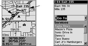
Find Highway Exit Services
For example, move your mouse pointer over a highway exit symbol on the computer map, and all you'll see is a pop-up tool-tip box listing the name of the exit. However, in a Lowrance or Eagle GPS unit, the same exit symbol will show a pop-up box with the exit name and symbols of all the services available near that exit. The GPS unit can also provide you a list of those services.
Cursor over |
Pop-up |
exit symbol |
box |
At left, an iFINDER GPS screen showing an exit services pop-up icon box. The iFINDER can then display a text list of those services near the selected exit, right.
13
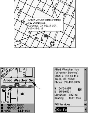
Find Points of Interest
On the computer master map, moving your pointer over a Point of Interest (POI) symbol triggers a pop-up box with the POI's name. With MapCreate 6.3, when the information is available, the pop-up box also displays the POI's address and telephone number. This detailed pop-up only works for items classified as Points of Interest.
Map with pop-up box showing POI information
In a Lowrance or Eagle GPS, all POI's include the name, address and phone number.
Cursor over
POI symbol 
Pop-up box
At left, an iFINDER GPS screen showing a POI pop-up name box. At right, you can call up a page of information on the POI, and the GPS unit can lead you to the POI's location.
Find an Address
You won't see addresses on your computer map (except listed in the pop-ups for some POIs). But when the MapCreate information is loaded into your GPS, you can search for a street address or a street intersection. In fact, your GPS unit can search by name for virtually every category of mapping detail contained in MapCreate.
14
All of this information is built into MapCreate's atlas database. As long as an information category is turned on and included in your Map File, the data will be available to your GPS unit.
With these and other elements, MapCreate gives you a phenomenal amount of mapping detail and information. For a more detailed list of the map categories available in MapCreate, see Appendix 2, Map Category List, on page 73.
How to use this manual: typographical conventions
Most Windows-based computer programs offer several ways to perform a task, and MapCreate 6 is no exception. With mouse and keyboard, you can access some commands four different ways! We'll show you all of them, but we save the most detailed information for our Help file's Command Reference section. There, the entry on each command includes a summary box showing all the menus and keyboard shortcuts (sometimes that's the only hint you need to get on with your mapping project.)
In our User's Guide segment (Sec. 3), we usually focus on one simple way to get the job done, usually by clicking the mouse pointer on a menu or toolbar button. In the User's Guide, many of the instructions are listed as numbered steps. This makes it a little easier to follow a series of instructions when you're skimming the material.
In the printed User's Guide and the Help file Command Reference, the actual command clicks and keystrokes appear as sans serif, boldface type. So, if you're in a real hurry (or just need a reminder), you can usually skim the instructions and pick out where to click by finding the boldface commands. The paragraphs below explain how to interpret the text formatting for those commands and other instructions. (If you're already familiar with Windows or many other software manuals you can probably skip forward to Section 2: Installation, on page 17.)
Mouse
The mouse controls the movement of a graphic symbol on your screen called the mouse pointer, sometimes also referred to as a mouse cursor. The mouse performs an action by moving the pointer over a menu, a button or the map and then clicking the appropriate mouse button.
When the word "click" is used alone, it means "left-click," or to press and release the left mouse button. When you need to use the right mouse button, we will say so explicitly, such as "Right-click on the waypoint."
Sometimes a command requires more than one click. When we say "double-click," it means to rapidly click the mouse button two times.
15
Keyboard
The keys on your keyboard may not be labeled exactly as they are in this manual. All key names are shown in bold, sans serif type. For example, the "Control" key is shown as Ctrl and the "Enter" key is shown as Enter.
Keys are sometimes used in combinations. For example, Ctrl+T means to hold down the Ctrl key while pressing the T key. The hot key sequence Alt+T|W indicates a two-step combination: hold down the Alt key while pressing the T key, release, then press the W key.
"Arrow keys" is the collective name for the up arrow, down arrow, left arrow and right arrow keys.
To choose a command from a menu, you can use the mouse or press a key combination.
Instructions
Words in small capital letters, in a bold sans serif type, indicate that you are to take an action of some kind with a command, menu, box or other item. For example, "You can use the Create Route command to plan a path to navigate with your GPS. To begin the route, choose
CREATE ROUTE."
When the phrase "choose command" is used in the Help file Command Reference section, it means to run or execute the specified command. For example, if the manual says "choose CREATE WAYPOINT," it means to run the Create Waypoint command. You can choose commands by clicking the mouse pointer on the menus or toolbar buttons, or by pressing the appropriate hot key or shortcut key on the keyboard.
Commands are sometimes described as menu sequences, to help you find the command faster. For example, "to open the Trail List window, click VIEW|TRAIL LIST," means to mouse click on the main menu's View command and then click the Trail List command on the submenu.
Specific text or numbers you must type are shown in bold, sans serif type. For example, if the manual says "Enter a Zoom range of 650 miles," you would click in the Zoom Range Window, type the numbers 650, then press the Enter key.
Place holders for other items you must supply yourself, such as file names, are italicized. For example, when the manual says "Enter a name in the File Name text box," you would click in the text box, type the name you want to use for the file, then press the Enter key.
This manual is written specifically for MapCreate 6.3, but for simplicity, the program is often referred to as "MapCreate" or "MapCreate 6."
16
Section 2: Installing MapCreate 6.3
System Requirements
MapCreate 6 requires the following minimum system resources:
•IBM compatible PC.
•Pentium 133 MHz or faster processor.
•32 MB RAM
•approximately 300 MB free hard disk space, depending on your version of the program.
•256 color display.
•Microsoft Windows 98 or later.
•CD-ROM drive.
MapCreate will run on a system with the above specifications, but the program will work slowly. A faster processor and more RAM will significantly improve program operation. You can also optimize performance by installing as much of the program as possible to run from your hard drive instead of the CD-ROM drive. (Do this by using the Custom or Full install modes, described below.)
IMPORTANT NOTES:
For copy protection purposes, you must have one of the MapCreate CDs in the disc drive each time you launch MapCreate.
Depending on the type of installation you select, you may remove the CD after starting the program. (This allows you to use the CD drive for another purpose, such as listening to music, while working with maps and GPS data.)
The data used in our maps is copyrighted. To prevent illegal copying of this data, all maps built by MapCreate are required to be encrypted (locked) to a specific memory card. Encryption requires MapCreate to retrieve unique information from your card. This requires special software not compatible with third party card readers, so MapCreate will only work with the MMC/SD card reader provided by LEI. (MapCreate 6.3 will also work with older Lowrance Electronics USB card readers.) If the card reader is not correctly installed with the LEI drivers, MapCreate will not open. After all the MapCreate files are installed, the installation program will install the drivers for the LEI card reader.
Installation Types
There are three types of installations:
Compact - Installs navigational aid data, the low-detail background map (Master Map) data and world-wide, me-
17
dium-detail map data. Takes approximately 300 MB of free hard drive space.
Custom - Allows installation of the program and all map data files on the hard drive. Caution: Be patient if you choose custom install. It may take several minutes for all the files to install to the hard drive. You will be prompted to insert the appropriate disc(s) throughout the installation.
Full - Installs every possible option and all the mapping data. MapCreate runs fastest with this option. Caution: Be patient if you choose full install. It may take several minutes for all the files to install to the hard drive. You will be prompted to insert the appropriate disc(s) throughout the installation..
For Compact or Custom installations of version 6.3: the high detail map data is organized into multiple regions recorded on different CDs. The manual addendum shipped with your MapCreate package contains a map showing which region is on which CD. Refer to the map to help you decide what regions to install on your hard drive.
Installing MapCreate
For best performance, we suggest you uninstall previous versions of MapCreate before installing version 6.3. To install MapCreate, follow these steps:
WARNING:
You must close all other open applications and temporarily disable any virus scan software before you install MapCreate. Some virus scanning programs will cause undefined error messages and prevent MapCreate from installing correctly. If strange errors occur during install, make sure virus scan software is off, then reinstall MapCreate. When installation is finished, remember to turn your virus scan software back on only after your computer has rebooted and MapCreate and the card reader are installed.
1.Insert the USA-West CD-ROM (or disc 1) into the computer's drive.
2.The MapCreate 6.3 setup program should start automatically and you can skip to step 5. If it does not, click the Windows START|RUN button.
18
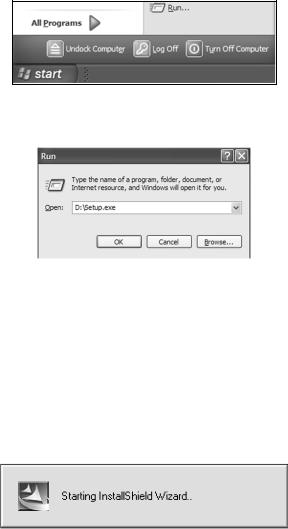
Click the START button on the Windows taskbar, and then click RUN.
3. Type D:\setup.exe (where D: is the drive letter for your CD-ROM)
Type the setup command directory path and file name.
4. Click OK to begin installation.
NOTE:
If you are using Windows 2000 or Windows XP Professional, you may receive an error message if you are not logged on with administrator privileges. If this occurs, you can complete the MapCreate installation by first logging on as an administrator, then proceeding with step 1 on page 18.
5. Follow the on-screen instructions:
19
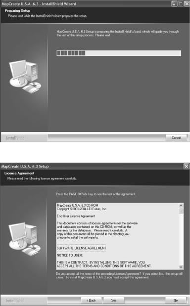
A. InstallShield will load. A message box will appear, reminding you to disable any anti virus software. Click OK to continue.
B.Read the complete License Agreement. If you accept the agreement, click the YES button; if you do not accept, click the NO button, and
MapCreate will not be installed on your computer.
20
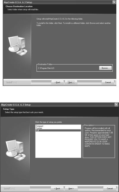
C. Choose a destination folder for the program. You can accept the default (recommended) or you can choose another location. Click NEXT to continue the installation.
D. Select the type of setup, and click the NEXT button to continue the installation. (See page 17 for a description of the options.)
21
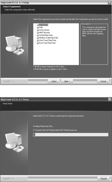
E. If you chose Custom install, select the components to install. Then click NEXT to continue.
F. With all your preferences determined, InstallShield will begin copying files. A progress window is shown.
22
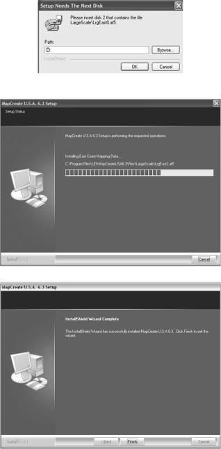
G. If needed, the install will prompt you for additional discs. When asked, insert the appropriate CD and click OK to continue the setup.
H. The Setup Status window shows the progress of the installation.
I. When the program files have been copied, InstallShield Wizard will display a message that setup is complete. Click FINISH to close the wizard program.
23

J. After the MapCreate files have been installed on your computer, you are prompted to install the MMC card reader drivers. Make sure the card reader is not plugged in yet, then click OK to continue. (If you stop the program, you can install the card reader later, but MapCreate will not run until the card reader is installed. To install later refer to the instruction sheet that came with the card reader.)
K. The setup program for the USB SD/MMC Reader loads.
L. When the setup program has loaded, a welcome screen is displayed. Click the NEXT button when you're ready to begin the card reader installation.
24
 Loading...