


Owner’s Manual
GPSMAP® 3006C/3010C

© 2004–2007 Garmin Ltd. or its subsidiaries |
|
|
||
Garmin International, Inc. |
Garmin (Europe) Ltd. |
Garmin Corporation |
||
1200 East 151st Street, |
Liberty House |
No. 68, Jangshu 2nd Road, |
||
Olathe, Kansas 66062, USA |
Hounsdown Business Park, |
Shijr, Taipei County, Taiwan |
||
Tel. |
(913) |
397.8200 or (800) 800.1020 |
Southampton, Hampshire, SO40 9RB UK |
Tel. 886/2.2642.9199 |
Fax |
(913) |
397.8282 |
Tel. +44 (0) 870.8501241 (outside the UK) |
Fax 886/2.2642.9099 |
|
|
|
0808 2380000 (within the UK) |
|
|
|
|
Fax +44 (0) 870.8501251 |
|
All rights reserved. Except as expressly provided herein, no part of this manual may be reproduced, copied, transmitted, disseminated, downloaded or stored in any storage medium, for any purpose without the express prior written consent of Garmin. Garmin hereby grants permission to download a single copy of this manual onto a hard drive or other electronic storage medium to be viewed and to print one copy of this manual or of any revision hereto, provided that such electronic or printed copy of this manual must contain the complete text of this copyright notice and provided further that any unauthorized commercial distribution of this manual or any revision hereto is strictly prohibited.
Information in this document is subject to change without notice. Garmin reserves the right to change or improve its products and to make changes in the content without obligation to notify any person or organization of such changes or improvements. Visit the Garmin Web site (www.garmin.com) for current updates and supplemental information concerning the use and operation of this and other Garmin products.
Garmin® is a trademark of Garmin Ltd. or its subsidiaries, registered in the USA and other countries. GPSMAP®, AutoLocate®, TracBack®, BlueChart®, BlueChart® g2™, MapSource®, See-Thru®, DynaColor™, and Ultrascroll™ are trademarks of Garmin Ltd. or its subsidiaries. These trademarks may not be used without the express permission of Garmin.
November 2007 |
Part Number 190-00371-00 Rev. G |
Printed in Taiwan |

Introduction > Installing Your GPSMAP 3006C/3010C and About This Manual
Introduction
Thank you for choosing the Garmin® GPSMAP® 3006C/3010C. The GPSMAP 3006C/3010C uses the proven performance of Garmin GPS and full-featured mapping to create an unsurpassed marine Multi-Function Display (MFD). Take a moment now to compare the contents of this package with the packing list on the outside of the box. If any pieces are missing, contact your Garmin dealer immediately.
Installing Your GPSMAP 3006C/3010C
To install the GPSMAP 3006C/3010C, refer to the GPSMAP 3006C/3010C & GPS 17 Installation Instructions. To complete the installation, you need the appropriate fasteners, tools, and mounts listed in each section. Installation items not provided by Garmin should be available at most marine dealers. If you experience difficulty installing the unit, contact Garmin Product Support or an installation professional in your area.
About This Manual
To get the most out of your new navigation system, read this manual and learn the operating procedures for your unit in detail. This manual is organized into the following sections:
The Introduction contains the Table of Contents, Product Registration, and the Software License Agreement.
The Getting Started section provides a unit overview and information that provides basic working knowledge needed to use the GPSMAP 3006C/3010C.
The Basic Operation section provides you with details and step-by-step instructions such as creating and using waypoints, navigating a route, and using the FIND key.
The Main Pages section provides detailed explanations about each page in the GPSMAP 3006C/3010C and step-by-step directions on using the pages.
The Main Menu section provides detailed explanations about the Main Menu and how to use it to configure your unit.
The Using Sonar section provides instructions on using a Garmin GSD 20,
GSD 21 (Serial), or a GSD 22 (Ethernet) sounder with your GPSMAP 3006/3010.
The XM WX Weather section provides instructions on using a GDL 30/ GDL 30A Marine Weather Satellite Receiver with your GPSMAP 3006/3010.
The Radar section provides instructions on using a GMR 20/40, GMR 21/41 or GMR 404/406 radar with your GPSMAP 3006/3010.
The Appendix contains specifications, regulatory information, unit care information, optional accessories, and maintenance information.You can also find warranty and FCC information in the Appendix.
An Index is provided at the end of the manual for reference.
GPSMAP 3006C/3010C Owner’s Manual |
|

Introduction > Table of Contents
Table of Contents |
|
Introduction............................................................................................... |
i |
Installing Your GPSMAP 3006C/3010C........................................................... |
i |
About This Manual........................................................................................... |
i |
Product Registration...................................................................................... |
v |
Contact Garmin......................................................................................................... |
v |
Software License Agreement......................................................................... |
v |
Warnings......................................................................................................... |
vi |
Important Information.................................................................................... |
vi |
Getting Started......................................................................................... |
1 |
Unit Overview.................................................................................................. |
1 |
Using the GPSMAP 3006C/3010C Keypad.................................................... |
2 |
Using the Optional Marine Remote Control............................................................. |
3 |
Using Soft Keys........................................................................................................ |
4 |
Using Data Entry/Shortcut Keys............................................................................... |
4 |
Status Bar.................................................................................................................. |
4 |
Turning on the GPSMAP 3006C/3010C......................................................... |
5 |
Adjusting the Backlight............................................................................................. |
5 |
Initializing the GPS Receiver......................................................................... |
6 |
Receiver Status and Accuracy................................................................................... |
7 |
GPS Setup................................................................................................................. |
7 |
Using Simulator Mode.................................................................................... |
8 |
Basic Operation........................................................................................ |
9 |
Using the GPSMAP 3006C/3010C.................................................................. |
9 |
Understanding the Features....................................................................................... |
9 |
Selecting Options and Entering Data...................................................................... |
10 |
Using Additional Map Data..................................................................................... |
11 |
Using the Map Pointer............................................................................................. |
11 |
Finding an Item............................................................................................. |
13 |
Creating and Using Waypoints.................................................................... |
14 |
Creating Waypoints Using the ENTER/MARK Key.............................................. |
14 |
Creating Waypoints Using the Map........................................................................ |
14 |
Creating Waypoints Manually................................................................................. |
15 |
Reviewing and Editing Waypoints............................................................... |
16 |
Moving a Waypoint................................................................................................. |
18 |
Using Waypoint Lists.............................................................................................. |
18 |
User Waypoints....................................................................................................... |
19 |
Proximity Waypoints............................................................................................... |
20 |
Navigating to a Destination.......................................................................... |
21 |
Selecting a Map Item Go To Destination................................................................ |
21 |
Follow Track and TracBack Navigation.................................................................. |
22 |
TracBack Tips.......................................................................................................... |
24 |
Man OverBoard (MOB)................................................................................. |
25 |
Creating and Using Routes.......................................................................... |
25 |
Creating a New Route............................................................................................. |
25 |
Navigating a Saved Route....................................................................................... |
26 |
Creating a Quick NAV Route.................................................................................. |
27 |
Copying a Route...................................................................................................... |
27 |
Deleting a Route...................................................................................................... |
28 |
Editing a Route........................................................................................................ |
28 |
Planning Routes....................................................................................................... |
31 |
Main Pages............................................................................................. |
32 |
Configuring Main Pages............................................................................... |
33 |
Using Function Windows............................................................................. |
35 |
Function Window Adjustments............................................................................... |
35 |
Viewing a Main Page in Full-Screen Mode............................................................ |
36 |
Map Page....................................................................................................... |
36 |
Selecting Map Ranges............................................................................................. |
37 |
Cartography............................................................................................................. |
38 |
Map Page Options................................................................................................... |
39 |
ii |
GPSMAP 3006C/3010C Owner’s Manual |

Introduction > Table of Contents
Map Split Page.............................................................................................. |
41 |
Compass Page.............................................................................................. |
41 |
3D Highway Page.......................................................................................... |
42 |
Changing the Highway Perspective Range............................................................. |
43 |
3D Highway Page Options...................................................................................... |
43 |
Showing or Hiding Maps........................................................................................ |
43 |
Video Page..................................................................................................... |
44 |
Video Page Options................................................................................................. |
44 |
Main Menu............................................................................................... |
45 |
GPS Tab......................................................................................................... |
45 |
Tide Tab.......................................................................................................... |
46 |
Tide Sub Tab............................................................................................................ |
46 |
Current Sub Tab....................................................................................................... |
48 |
Celestial Tab.................................................................................................. |
49 |
Trip Tab.......................................................................................................... |
50 |
Weather Tab................................................................................................... |
51 |
Points Tab...................................................................................................... |
51 |
Routes Tab..................................................................................................... |
52 |
Tracks Tab...................................................................................................... |
53 |
DSC (Digital Selective Calling) Tab............................................................. |
54 |
Understanding DSC Distress Calls......................................................................... |
55 |
Understanding Position Reports.............................................................................. |
55 |
Review DSC Waypoint........................................................................................... |
55 |
Setting Up DSC....................................................................................................... |
56 |
Using the NAV Key................................................................................................. |
56 |
Card Tab......................................................................................................... |
57 |
Messages Tab................................................................................................ |
58 |
Viewing Detailed Message Information.................................................................. |
58 |
Alarms Tab..................................................................................................... |
58 |
System Alarms......................................................................................................... |
59 |
Nav (Navigation) Alarms........................................................................................ |
59 |
Sonar Alarms........................................................................................................... |
60 |
Weather Alarms....................................................................................................... |
60 |
System Tab.................................................................................................... |
61 |
Update Sub Tab....................................................................................................... |
66 |
Network Tab................................................................................................... |
66 |
Pages Tab...................................................................................................... |
67 |
Map Tab.......................................................................................................... |
68 |
AIS Sub Tab............................................................................................................ |
71 |
Radar Tab....................................................................................................... |
72 |
Temp (Temperature) Tab............................................................................... |
73 |
Sonar Tab....................................................................................................... |
73 |
Highway Tab.................................................................................................. |
74 |
XM Tab............................................................................................................ |
74 |
Using Favorites....................................................................................................... |
75 |
Using Sonar............................................................................................ |
76 |
Understanding Sonar................................................................................... |
76 |
Using Dual Frequency............................................................................................. |
76 |
Using Dual Beam.................................................................................................... |
76 |
Understanding the Sonar Display............................................................................ |
77 |
Sonar Page.................................................................................................... |
78 |
Configuring the Sonar Page..................................................................................... |
79 |
Using the Sonar Adjustment Menu......................................................................... |
80 |
Using the Pointer on the Sonar Page....................................................................... |
82 |
Marking an Underwater Waypoint.......................................................................... |
82 |
Sonar Tab....................................................................................................... |
82 |
General Sub Tab...................................................................................................... |
83 |
Graph Sub Tab......................................................................................................... |
84 |
Water Temp Sub Tab............................................................................................... |
85 |
GPSMAP 3006C/3010C Owner’s Manual |
|

Introduction > Table of Contents
XM WX Weather...................................................................................... |
86 |
Customizing Preset Weather Displays........................................................ |
86 |
Weather Tab................................................................................................... |
88 |
Marine Bulletins Sub Tab........................................................................................ |
88 |
Using Radar............................................................................................ |
89 |
Understanding Radar................................................................................... |
89 |
Understanding the Radar Display........................................................................... |
90 |
Radar Page.................................................................................................... |
91 |
Configuring the Radar Page.................................................................................... |
91 |
Using the Radar Adjustment Menu......................................................................... |
92 |
Map Page Radar Overlay.............................................................................. |
97 |
Radar Tab....................................................................................................... |
97 |
General Sub Tab...................................................................................................... |
98 |
Display Sub Tab...................................................................................................... |
98 |
MARPA Sub Tab..................................................................................................... |
99 |
Advanced Sub Tab................................................................................................. |
100 |
Appendix............................................................................................... |
101 |
Specifications.............................................................................................. |
101 |
Installing and Removing Data Cards........................................................ |
102 |
Satellite Information................................................................................... |
103 |
What is WAAS/EGNOS?............................................................................. |
103 |
WAAS Capability......................................................................................... |
104 |
Digital Selective Calling (DSC).................................................................. |
104 |
What is DSC?........................................................................................................ |
104 |
LORAN TD System...................................................................................... |
106 |
Caring for the GPSMAP 3006C/3010C....................................................... |
107 |
Navigation Terms........................................................................................ |
108 |
Messages and Alarms................................................................................ |
110 |
Optional Accessories................................................................................. |
112 |
Limited Warranty......................................................................................... |
113 |
FCC Compliance......................................................................................... |
114 |
Industry Canada Compliance................................................................................ |
114 |
Declaration of Conformity (DoC)............................................................... |
114 |
XM Satellite Radio Service Agreement..................................................... |
114 |
Weather Data Warranty............................................................................... |
115 |
European License Requirements.............................................................. |
116 |
Index....................................................................................................... |
117 |
iv |
GPSMAP 3006C/3010C Owner’s Manual |

Introduction > Product Registration and Software License Agreement
Product Registration
Help us better support you by completing our online registration today! Connect to our Web site at my.garmin.com. Keep the original sales receipt, or a photocopy, in a safe place.
Contact Garmin
Contact Garmin if you have any questions while using your
GPSMAP 3006C/3010C. In the USA contact Garmin Product Support by phone: (913) 397-8200 or (800) 800-1020, Monday–Friday, 8 AM–5 PM Central Time; or go to www.garmin.com/support/.
In Europe, contact Garmin (Europe) Ltd. at +44 (0) 870.8501241 (outside the UK) or 0808 2380000 (within the UK).
Software License Agreement
BY USING THE GPSMAP 3006C/3010C, YOU AGREE TO BE BOUND BY THE TERMS AND CONDITIONS OF THE FOLLOWING SOFTWARE
LICENSE AGREEMENT. PLEASE READ THIS AGREEMENT CAREFULLY.
Garmin grants you a limited license to use the software embedded in this device (the “Software”) in binary executable form in the normal operation of the product. Title, ownership rights, and intellectual property rights in and to the Software remain in Garmin.
You acknowledge that the Software is the property of Garmin and is protected under the United States of America copyright laws and international copyright treaties. You further acknowledge that the structure, organization, and code of the Software are valuable trade secrets of Garmin and that the Software in source code form remains a valuable trade secret of Garmin. You agree not to decompile, disassemble, modify, reverse assemble, reverse engineer, or reduce to human readable form the Software or any part thereof or create any derivative works based on the Software. You agree not to export or re-export the Software to any country in violation of the export control laws of the United States of America.
GPSMAP 3006C/3010C Owner’s Manual |
v |

Introduction > Warnings and Important Information
 Warnings
Failure to avoid the following potentially hazardous situations could result in an |
• |
Use the electronic chart in the unit only to facilitate, not to replace, the use of |
||
accident or collision resulting in death or serious injury. |
|
authorized government charts. Official government charts and notices to mariners |
||
• |
When navigating, carefully compare information displayed on the unit to all |
|
contain all information needed to navigate safely. |
|
• |
Use this unit only as a navigational aid. Do not attempt to use the unit for any |
|||
|
available navigation sources, including information from visual sightings, and |
|||
|
maps. For safety, always resolve any discrepancies or questions before continuing |
|
purpose requiring precise measurement of direction, distance, location, or |
|
|
navigation. |
|
topography. |
|
WARNING: This product, its packaging, and its components contain chemicals known to the State of California to cause cancer, birth defects, or reproductive harm. This Notice is provided in accordance with California’s Proposition 65. See www.garmin.com/prop65 for more information.
The California Electronic Waste Recycling Act of 2003 requires the recycling of certain electronics. For more information on the applicability to this product, see www.erecycle.org.
Hg - lampS inside this product contain mercury and must be recycled or disposed of according to local, state, or federal laws.
For more information go to: www.garmin.com/aboutGarmin/environment/disposal.jsp
Important Information
MAP DATA INFORMATION: One of the goals of Garmin is to provide customers with the most complete and accurate cartography that is available to us at a reasonable cost. We use a combination of governmental and private data sources, which we identify in product literature and copyright messages displayed to the consumer. Virtually all data sources contain some inaccurate or incomplete data. In some countries, complete and accurate map information is either not available or is prohibitively expensive.
vi |
GPSMAP 3006C/3010C Owner’s Manual |
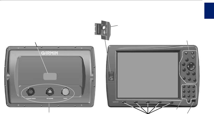
Unit Overview
Serial number tag
Connection ports
Getting Started
Data card slots
Getting Started > Unit Overview
Started
Getting
Data card slot 1
 Data card slot 2
Interface keys
6/,
|
|
|
|
|
0!'% |
|
|
|
|
|
15)4 |
|
|
|
|
|
|
%.4%2 |
|
|
|
|
|
|
-!2+ |
|
|
|
|
|
|
|
!$* |
.!6 |
|
|
|
|
|
-%.5 |
-/" |
|
|
|
|
$!4! |
|
|
|
|
|
|
#.&' |
. |
|
|
|
|
|
|
&).$ |
|
|
|
|
|
|
|
|
|
|
|
|
|
!"# |
$%& |
|
|
|
|
|
|
|
|
|
|
|
'() |
*+, |
-./ |
|
|
|
|
|
|
|
|
|
|
|
0123 |
456 |
789: |
|
|
|
|
|
|
|
|
|
|
|
|
|
|
> |
> |
> |
> |
|
|
|
> |
|
|
|
Data entry keys |
Soft keys |
Infrared (IR) window |
GPSMAP 3010C Shown |
(For optional remote control) |
|
GPSMAP 3006C/3010C Owner’s Manual |
1 |
ettG ni g tartedS
Getting Started > Using the GPSMAP 3006C/3010C Keypad
Using the GPSMAP 3006C/3010C Keypad
POWER/BACKLIGHT Key
•Press and hold to turn the unit on or off.
•Press and release to adjust backlighting.
PAGE Key
• Press to cycle through the main pages in sequence.
• Press to end an operation in progress and |
|
|
|
||
return to the main page. |
|
0!'% |
|
||
QUIT Key |
|
|
|
||
|
|
|
|||
• Press to cancel data entry or exit a page. |
15)4 |
|
|
||
ENTER/MARK Key |
|
|
|
||
|
|
|
|
|
|
• Press and release to enter highlighted items |
%.4%2 |
|
|
||
and data or confirm on-screen messages. |
-!2+ |
|
|
||
|
|
|
|||
• Press and hold to mark your current location |
|
-%.5 |
.!6 |
||
|
|
|
|
!$* |
|
as a waypoint. |
|
|
-/" |
||
|
|
|
|||
DATA/CNFG Key |
|
$!4! |
|
|
|
• Press to show or hide function windows and |
#.&' |
. |
&).$ |
||
|
|||||
|
|
||||
data fields on a main page.
•Press and hold to open the Configuration window.
RANGE Keys
•Press to zoom in or out on the map.
•Press to adjust the range of the sonar and radar
ROCKER Key
•Press up, down, right, or left to move through lists, highlight fields, enter data, or move the map pointer.
ADJ/MENU Key
•Press and release to view options for a page.
•Press and hold to open the Main Menu.
NAV/MOB Key
•Press to open the Navigation Menu.
•Press and hold to mark a MOB waypoint and create a track back to the marked location.
FCTN Key
• Press to cycle through function windows.
FIND Key
•Press to search for points, such as user waypoints, cities, and services.
GPSMAP 3006C/3010C Owner’s Manual
Getting Started > Using the GPSMAP 3006C/3010C Keypad
Using the Optional Marine Remote Control
Use the keypad on the optional Marine Remote Control to operate your GPSMAP 3006C/3010C from a distance. Contact your Garmin dealer or Garmin Product Support to purchase the Marine Remote Control.
To operate the remote control, point the IR (infrared) window on the remote toward the unobstructed IR window on the lower-right corner of the GPSMAP 3006C/3010C.
All keys on the remote control operate in the same manner as the keypad on the GPSMAP 3006C/3010C. Each key’s primary function appears on the key. To activate the secondary functions for the ADJ/MENU, NAV/MOB, DATA/CNFG, and Thumb Stick (ENTER/MARK) keys, press and hold the key.
The Thumb Stick combines the operations of the ROCKER and ENTER/MARK key. Use it to select menu options, change settings, enter data, and confirm entry. You can also control movement of the pointer on the Map
Page. Press in on the Thumb Stick to select a highlighted item or begin data entry. Press and hold the Thumb Stick to mark a waypoint.
Installing the Remote Control Batteries
The remote requires two AAA alkaline batteries. To install the batteries, press down on the battery door clip, and then pull the battery door away from the remote. Install the batteries, observing the correct polarity (see the inside of the battery compartment). Replace the cover, and make sure it is closed all the way.
Thumb Stick |
15)4 |
|
!$*$ |
|
-%.5 |
|
$!4! |
|
#.&' |
|
|
|
'() |
|
|
|
0123 |
|
|
IR window
://2!.'%-
|
0!'% |
%.4%2 |
|
|
.!6 |
|
-/" |
|
. |
!"# |
$%& |
|
|
*+, |
-./ |
|
|
456 |
789: |
|
|
|
|
|
|
NOTE: The remote is for use in shaded or enclosed environments. Direct sunlight interferes with infrared operation. The Marine Remote Control is NOT
waterproof.
Marine Remote Control
Started
Getting
GPSMAP 3006C/3010C Owner’s Manual |
3 |

ettG ni g tartedS
Getting Started > Using the GPSMAP 3006C/3010C Keypad
Using Soft Keys
Soft keys are located along the bottom of the display and are used as shortcuts to select the most commonly used options for the selected page, window, or tab. To select a soft key, press the  key directly below it.
Soft keys
Status Bar
At the top of each page, the status bar provides current status information for connected devices and several of the chartplotter functions. As additional devices are added to the GPSMAP 3006/3010 or the Garmin Marine Network, an icon for each device appears on the status bar.
Status bar
> |
> |
> |
> |
> |
Using Data Entry/Shortcut Keys
|
!"# |
$%& |
|
|
|
'() |
*+, |
-./ |
|
|
|
0123 |
456 |
789: |
|
|
|
|
|
|
|
|
|
Use the data entry keys to enter alphanumeric data into the unit, such as a waypoint name. Use data entry keys in conjunction with the ROCKER. Press the key once to select the first letter on the key, twice to select the second letter on the key, three times
to select the third letter on the key, or four times to select the number on the key. When you have selected the correct letter or number, pause, and the unit advances the cursor to the next character automatically.
Use the shortcut keys to jump to main pages, or select menu and list options by pressing the corresponding number of the selection. For numbers 1-9, press the number to choose the selection. For
numbers 10 and higher, press the first digit, then press the second digit within one second.
Alarm alerts also appear on the status bar. To acknowledge an alarm, press QUIT. If an alarm condition persists, it appears on the status bar until the alarm condition no longer exists. For more information about alarms, see pages 58-60.
|
GPSMAP 3006C/3010C Owner’s Manual |
Getting Started > Turning on the GPSMAP 3006C/3010C
Turning on the GPSMAP 3006C/3010C
Before you turn on the GPSMAP 3006C/3010C, make sure the unit and GPS 17 antenna are correctly installed on your vessel according to the instructions in the
GPSMAP 3006C/3010C & GPS 17 Installation Instructions.
The first time you turn on the GPSMAP3006C/3010C, the GPS 17 receiver must collect satellite data and determine its current location. To ensure proper initialization, the GPSMAP 3006C/3010C is shipped from the factory in AutoLocate mode.
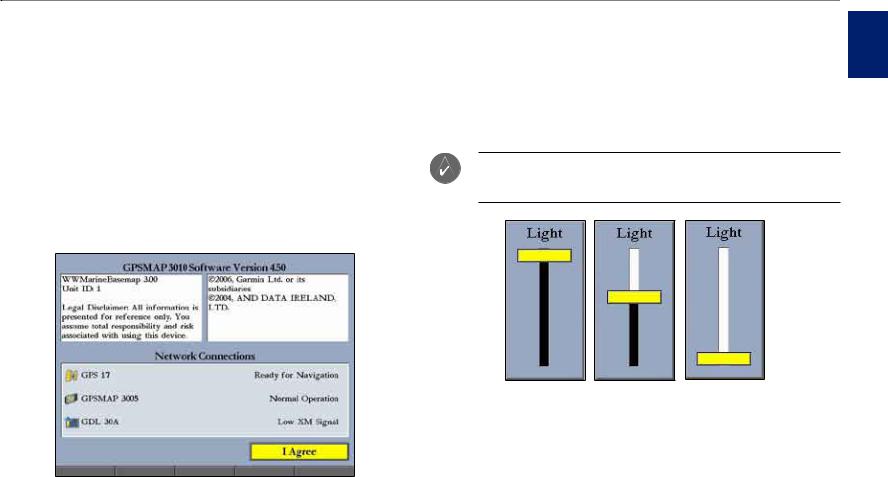
To turn on the GPSMAP 3006C/3010C:
1.Press and hold the POWER key until the unit turns on.
2.When I Agree is highlighted on the Warning Page, press ENTER to open the Map Page.
Adjusting the Backlight
You can adjust the screen backlighting on the GPSMAP 3006C/3010C from any page by using the POWER/BACKLIGHT key.
To adjust the backlight level:
1.Press and release the POWER/BACKLIGHT key.
2.Press up on the ROCKER to increase the brightness, or press down to decrease.
TIP: After you open the Backlight adjustment window, press the POWER/BACKLIGHT key repeatedly to cycle through the three backlight settings: Highest, Middle, and Lowest.
Started
Getting
Highest |
Middle |
Lowest |
3. Press ENTER or QUIT to close the Backlight adjustment window.
To turn off the GPSMAP 3006C/3010C:
Press and hold the POWER key until the unit turns off.
GPSMAP 3006C/3010C Owner’s Manual |
|
ettG ni g tartedS
Getting Started > Initializing the GPS Receiver
Initializing the GPS Receiver
When you turn on the GPSMAP 3006C/3010C, a Warning Page appears, showing unit information, network connections (attached devices), and important information regarding the proper use of the unit. It takes a few seconds for the GPSMAP 3006C/3010C to search for attached devices. When the search is complete, the I Agree button is highlighted. After reading the warning, press
ENTER.
Next, you see the first of the main pages, the Map Page. The GPSMAP 3006C/3010C begins searching for GPS satellites. The first time the unit acquires satellites takes several minutes. Afterward, acquisition times are quicker during normal use. The GPS status icon on the left side of the status bar shows the progress of the satellite acquisition process.
GPS status icon colors are:
•Red—acquiring satellites/lost satellite reception.
•Orange—ready for navigation/ready for navigation with WAAS.
•Gray—lost GPS connection. (Check GPS antenna wiring connections.)
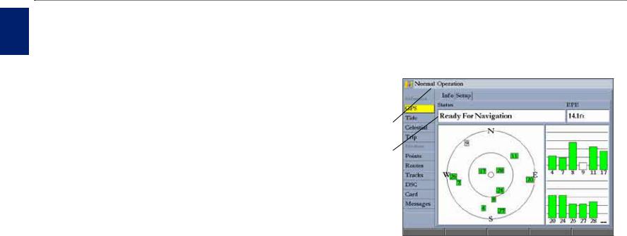
A detailed visual reference of the satellite acquisition, GPS receiver status, and accuracy is available on the GPS tab on the Main Menu.
To view the GPS tab information:
1.Press and hold ADJ/MENU to open the Main Menu.
2.Use the ROCKER to highlight the GPS tab.
When viewing the GPS Info sub tab, a signal strength bar for each satellite in view appears on the right of the page, with the appropriate satellite number underneath each bar. The numbers below each bar represent the particular satellite that is being received. Numbers above 33 indicate WAAS satellites. For more information about WAAS, see the “Appendix”.
The sky view shows a birds-eye view of the location of each satellite relative to the receiver’s last known location. The outer circle represents the horizon (north up), the inner circle 45º above the horizon, and the center point a location directly overhead. You can also set the sky view to track up, which causes the top of the sky view to align along your current track heading.
GPS status  icon
icon
Status bar
Status field
GPS Tab
The progress of satellite acquisition is shown in three stages:
•No signal strength bars—the receiver is looking for the satellites indicated.
•Hollow signal strength bars—the receiver has found the indicated satellite(s) and is collecting data.
•Solid green signal strength bars—the receiver has collected the necessary data and the satellite(s) are ready for use.
GPSMAP 3006C/3010C Owner’s Manual

Getting Started > Initializing the GPS Receiver
Receiver Status and Accuracy
The receiver status is shown in the Status field on the Info sub tab. Current accuracy is shown in the EPE (Estimated Position Error) field.Accuracy uses the number of received GPS satellites, signal strength, and satellite orientation, to calculate location accuracy in feet or meters. The Status field shows one of the following conditions:
•Searching for Satellites—the receiver is looking for any satellites and collecting data from satellites visible at its last known or initialized location, but has not collected enough data to calculate a fix. This process can take up to five minutes.
•Ready For Navigation—at least three satellites with good geometry have been acquired, and your location is now being calculated in latitude and longitude; or at least four satellites have been acquired and your location is being calculated in latitude, longitude, and elevation. “Ready For Navigation with WAAS” appears when you are receiving WAAS satellite corrections in 2D or 3D, and a D appears on the strength bar of satellites being corrected.
After the receiver has collected information from at least three satellites, the
Status field shows either “Ready for Navigation” or “Ready for Navigation with
WAAS”. The GPSMAP 3006C/3010C is now ready for use. Press QUIT to return to the Map Page.
GPS Setup
The Setup sub tab provides access to functions and features relating to initializing the GPS receiver.
To access the GPS Setup sub tab:
1.Press and hold ADJ/MENU to open the Main Menu.
2.Highlight the GPS tab, and then highlight the Setup sub tab.
Setup Sub Tab
The Setup sub tab contains the following options:
•Skyview Orientation—allows you to select a sky view orientation, either North Up or Track Up, for the GPS Info sub tab only.
•Source—set to Garmin when using a Garmin sensor (GPS 17); set to NMEA when using any other GPS NMEA source.
•WAAS—turns WAAS on or off.
The following soft keys are active only when the unit is not receiving satellites and the Source is not set to Garmin:
•AutoLocate—allows the receiver to find your location automatically. This process can take up to five minutes.
•Set Position—allows you to initialize the receiver from the Map Page to initially help the receiver acquire satellites more quickly.
Started
Getting
GPSMAP 3006C/3010C Owner’s Manual |
|
ettG ni g tartedS
Getting Started > Using Simulator Mode
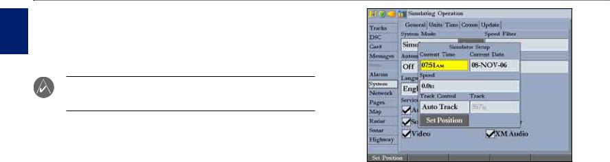
Using Simulator Mode
Simulator Mode is great for practicing with the unit if you are indoors and satellite signals are not available. When the GPSMAP 3006C/3010C is in Simulator Mode, the GPS receiver is turned off. The unit cannot be used for actual navigation.
Note: Do not try to navigate in Simulator Mode. While in Simulator Mode, the GPS receiver is turned off. Any satellite signal strength indicators shown are only simulations and do not indicate the strength of actual satellite signals.
To turn on Simulator Mode:
1.Press and hold ADJ/MENU to open the Main Menu.
2.Press up or down on the ROCKER to highlight the System tab.
3.Press right on the ROCKER to highlight the General sub tab.
4.Highlight the System Mode field, and press ENTER.
5.Highlight Simulator, and press ENTER.
When Simulator Mode is active, the message “Simulating Operation” appears in the status bar at the top of each page.
To set up Simulator Mode:
Highlight the Setup button, and press ENTER. The Simulator Setup window appears. The following options are available:
•Current Time/Date—enter a simulated date and time.
•Speed—enter a simulated speed.
•Track Control—select track control. Auto Track steers to the current navigation point; User Track allows you to enter a heading in the Track field.
•Track—enter a simulated heading.
Use the Set Position soft key to set your location while in Simulator Mode.
You can also control the speed and track from the Compass or 3D Highway Pages. Press up or down on the ROCKER to increase or decrease the speed; press left or right to change the heading.
To turn off Simulator Mode:
1.Press and hold ADJ/MENU to open the Main Menu.
2.Press up or down on the ROCKER to highlight the System tab.
3.Press right on the ROCKER to highlight the General sub tab.
4.Highlight the System Mode field, and press ENTER.
5.Highlight Normal, and press ENTER.
When Normal Mode is active, the message “Normal” appears in the status bar at the top of each page.
|
GPSMAP 3006C/3010C Owner’s Manual |
Basic Operation > Using the GPSMAP 3006C/3010C
Basic Operation
Highlighted field
Using the GPSMAP 3006C/3010C
This section explains how to enter and select information with the GPSMAP 3006C/3010C.
Understanding the Features
The advanced keypad system on the GPSMAP 3006C/3010C is designed to allow you to select options and enter data quickly and conveniently. As you progress through this owner’s manual, you are directed to press a specific key or highlight a field on the screen. When you are directed to press a key, you should press and quickly release the key. If you need to hold down the key for a period of time
to activate a secondary function, the instructions tell you to do so. The location of the highlight is controlled by the ROCKER. When a field is selected on the screen, it is highlighted in yellow.
The following terms are used throughout this manual:
•Highlight—move the highlighted area on the screen up, down, left, or right with the ROCKER to select individual fields. Moving the highlight to a given location allows you to make a selection, begin data entry, or scroll through a list.
•Field—the location on a page where data or an option can be entered and displayed. Highlight a field using the ROCKER to begin entering data or selecting options.
•Soft keys—located along the bottom of the screen, soft keys are used as shortcuts to select the most commonly used options for the selected page, window, or tab. To select a soft key, press the  key directly below it.
•On-Screen button—use the ROCKER to highlight an on-screen button, and press ENTER to select the button.
Field
On-screen 
button
Soft keys
•Scroll bar—When viewing a list of items too long to show on the screen, a scroll bar appears along the right side of the list. To scroll through a list, press up or down on the ROCKER. Press right or left on the ROCKER to scroll one page at a time.
•Default—the factory settings saved in the unit’s memory. You can change the settings, but you can also revert to the factory (default) settings when you press the FactoryDfltssoft key on the System–General sub tab.
Operation
Basic
GPSMAP 3006C/3010C Owner’s Manual |
|
asBci peratO oni
Basic Operation > Using the GPSMAP 3006C/3010C
Selecting Options and Entering Data
To select options and enter data, use the ROCKER to highlight or select an item in a list or a field on the screen. Use the ENTER key, soft keys, data entry keys, and the ROCKER to select options, enter names and numbers in data fields, and activate your selections.
To select an optional feature:
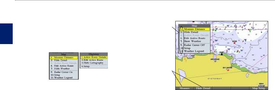
1.From any page, press ADJ. The adjustment menu shows a list of optional features specific to that page.
2.Press the data entry key that corresponds to the option you want to select. For numbers 10 and higher, press the first digit, and then press the second digit within one second.
Data entry key shortcut numbers
2.Use the ROCKER to move the highlight up, down, left, or right to the selection you want, and press ENTER to select the option.
OR
Press the soft key below the option you want to select.
To select an on-screen button:
On a page with on-screen buttons, use the ROCKER to highlight an on-screen button, and press ENTER.
To select an option using soft keys:
Press the  button below the soft key you want to select.
To select an option using data entry shortcut keys:
1.From any page, press ADJ. The adjustment menu for the current page or selected function appears.
Soft keys
To exit a menu or return to the previous setting:
Press QUIT. The QUIT key moves backward through your steps. Press QUIT repeatedly to return to the starting page.
To enter data in a data field:
1.Use the ROCKER to highlight the data field, and press ENTER.
2.Press up or down on the ROCKER to select characters. Press and release the ROCKER to move character by character through the list; press and hold the ROCKER to move rapidly through the list.
10 |
GPSMAP 3006C/3010C Owner’s Manual |
|
|
|
Basic Operation > Using the GPSMAP 3006C/3010C |
||
3. Press right on the ROCKER to move to the next character on the line |
Using the Map Pointer |
||||
or press left to move back to the previous character. Press left on the |
Use the map pointer to pan away from your current location and scroll to other |
||||
ROCKER from the first character position to clear the field. If there are |
map areas around the world (even outside of your current detail coverage). As |
||||
more than two lines of data, keep pressing right on the ROCKER to go to |
you pan past the edge of the current map display, the screen actively scrolls |
||||
the next line. |
|||||
forward to provide continuous map coverage. An hourglass symbol appears by |
|||||
4. Press ENTER to accept data and move to the next field. |
|||||
the pointer while the unit is busy drawing new map detail. |
|||||
Not all data fields are programmable. When moving around a page with these |
|||||
Controlled by the ROCKER, the map pointer is an important tool that can be |
|||||
fields, the highlight skips them. |
|||||
used to pan to other map locations, mark and edit waypoints and routes, and |
|||||
|
|
||||
Using Additional Map Data |
review location data of on-screen map items and waypoints. |
||||
The GPSMAP 3006C/3010C comes standard with a built-in basemap |
|
Map item name, pointer coordinates, |
|||
showing cities, interstates, coastline detail, and U.S. Tide stations. Optional |
|
||||
|
distance, and bearing |
||||
preprogrammed Garmin data cards and MapSource CD-ROMs and DVDs |
|
|
|
||
|
|
|
|||
enhance the versatility of your GPSMAP 3006C/3010C. With optional BlueChart |
|
|
|
||
cartography, you can access marine navaids, wrecks, obstructions, anchorage |
|
|
|
||
locations, shaded depth contours, inter-tidal zones, spot soundings, port plans, and |
|
|
|
||
more. |
|
|
|
||
The GPSMAP 3006C/3010C supports BlueChart® g2™ cartography. This |
|
|
|
||
cartography features integrated mapping, 2-D or 3-D map perspective, tide and |
|
|
|
||
current data, improved IALA symbols, navaids, marinas, boat ramps, roads, and |
|
|
|
||
more. You can also access additional data including highly detailed coastal roads |
|
|
Map |
||
and points of interest such as restaurants, lodging, and local attractions. Full-color |
|
|
pointer |
||
aerial photographs of ports, marinas, bridges, and navigational landmarks are also |
|
|
|
||
included on many preprogrammed BlueChart g2 data cards. |
|
|
|
||
See your Garmin dealer or visit the Garmin Web site (www.garmin.com) for |
|
|
|
||
|
|
|
|||
more information on preprogrammed Garmin data cards and other MapSource |
To move the map pointer: |
||||
programs. |
|
Press the ROCKER to move the map pointer up, down, left, right, or |
|||
|
|
|
diagonally. |
||
|
NOTE: When networking with a Garmin GPSMAP 4000 or 5000 series unit, |
|
|
|
|
|
map data is not shared. |
|
|
|
|
Operation
Basic
GPSMAP 3006C/3010C Owner’s Manual |
11 |
asBci peratO oni
Basic Operation > Using the GPSMAP 3006C/3010C
As you move the map pointer, the distance and bearing from your current |
To eliminate the pointer and re-center your location on the map: |
|||
location to the map pointer are shown in the upper-left corner of the map, with |
Press QUIT. |
|||
the map pointer’s location coordinates. Keep in mind that when the map pointer |
To view additional BlueChart chart notes: |
|||
is stationary, the distance and bearing from your present location changes as your |
||||
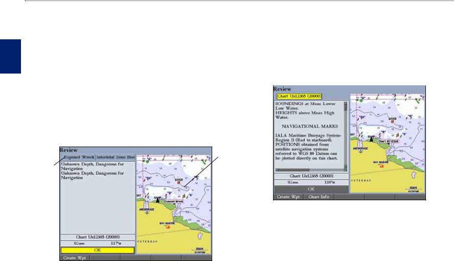
1. Select an on-screen BlueChart map item, and press ENTER. |
||||
boat moves. The map pointer can also be used to jump to an on-screen waypoints |
||||
2. Use the ROCKER to highlight the Chart <name> tab. A chart summary |
||||
and map items, allowing you to review a selected location directly from the map. |
||||
appears below the tab. |
||||
|
||||
To select an on-screen waypoint or map item with the map pointer: |
3. Highlight the Notes soft key, and press ENTER. Notes for the chart |
|||
1. Use the ROCKER to move the pointer to the waypoint or map item. When |
appear. |
|||
a waypoint or map item is selected, it is highlighted on-screen with the |
|
|
|
|
|
|
|
||
name and location shown. |
|
|
|
|
2. Press ENTER to view details of the map item. When using BlueChart or |
|
|
|
|
MapSource data, or if waypoints are grouped tightly together due to the |
|
|
|
|
Range setting, additional tabs appear on the Review Waypoint Page. Use |
|
|
|
|
the ROCKER to highlight the individual tabs to view the information and |
|
|
|
|
additional options. |
|
|
|
|
Map Additional window information
tabs
BlueChart Notes
4. Highlight the notes field, and press ENTER. 5. Use the ROCKER to scroll the text up or down. 6. Press QUIT to exit.
12 |
GPSMAP 3006C/3010C Owner’s Manual |
Basic Operation > Finding an Item
Finding an Item
Press FIND to search for items including waypoints, anchorages, cities, marine services, navaids, restricted areas, wrecks, celestial information, tides, and currents. If you pan the map window and press FIND, the unit centers its search from the map pointer location. When using BlueChart, BlueChart g2, or
MapSource data, your location or the map pointer must be within the map outline area to search for information from that area.
To find an item from your current location:
1. From any page, press FIND to open the Find From Current Position Page.
2.Highlight a category, and press ENTER. Select a subcategory, if necessary.
3.Some items have a By Name tab. For By Name, select the top field to spell out the name, or scroll through the list.
4.Some items have a Filter List button that allows you to enter letters or numbers of the item name. The search result shows only items matching the entered letters or numbers. Highlight the Filter List button, and press ENTER. Enter data, as needed, to narrow your search.
To find an item from another location on the map:
1.Open the Map Page. Use the ROCKER to pan to the location you want, and then press FIND. The Find From (Location) Page appears.
2.Using the ROCKER, highlight a category, and press ENTER.
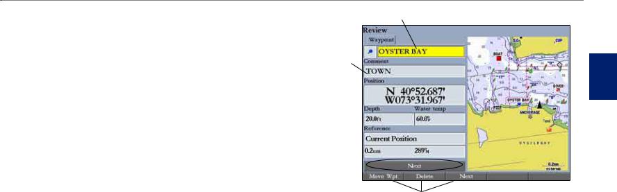
To view details about an item:
Highlight an item in the search results list, and press ENTER. The Review Page appears, showing item information, map location, chart name, distance/bearing, and options for creating a waypoint or viewing the next item in the search results list.
Item information
Chart name
Distance  and bearing
Soft keys
Operation
Basic
GPSMAP 3006C/3010C Owner’s Manual |
13 |
asBci peratO oni
Basic Operation > Creating and Using Waypoints
Creating and Using Waypoints
The GPSMAP 3006C/3010C stores up to 4,000 alphanumeric waypoints, each with a user-defined icon, comment, depth, and water temperature.
NOTE: If you are using a Garmin GSD 20, GSD 21, or GSD 22 Sounder Module, the Depth and Water Temp fields fill in automatically.
You can create waypoints using three basic methods:
•ENTER/MARK—use the ENTER/MARK key to quickly mark your current location.
•Graphically—use the map display to define a new waypoint location.
•Manually—enter new waypoint coordinates manually.
Creating Waypoints Using the ENTER/MARK Key
Use the ENTER/MARK key to capture your current location or pointer or map item location to create a new waypoint.You must have a valid position fix to mark your current location.
To mark your current location:
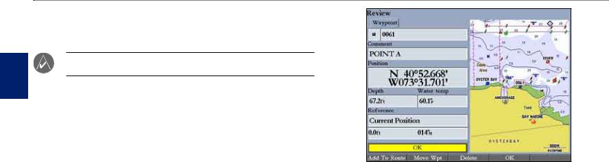
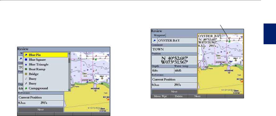
1.Press and hold ENTER/MARK until the Review Waypoint Page appears. The GPSMAP 3006C/3010C captures its current location and creates a default name and symbol for the new waypoint.
2.To accept the waypoint with the default name and symbol, press ENTER. To change any of the available waypoint information, see page 16.
Review Waypoint Page (BlueChart Data Shown)
Creating Waypoints Using the Map
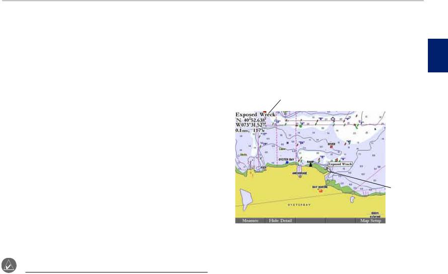
You can create a waypoint by using the map pointer to point to any map location or map feature. When you move the pointer over a map item, you see a highlighted description of the item.
To create a new waypoint using a map location:
1.Use the ROCKER to move the pointer to the map location you want.
2.Press and quickly release ENTER/MARK to capture the pointer location. Do not hold the button down; doing so marks your current location, not the map location. The Review Waypoint Page appears.
3.To accept the waypoint with the default information, press ENTER. OR
To change any waypoint information, highlight the appropriate field and press ENTER. After entering your changes, press the OK soft key.
14 |
GPSMAP 3006C/3010C Owner’s Manual |
To create a new waypoint from a map feature:
1.Use the ROCKER to move the map pointer and highlight the map feature you want.
2.Press ENTER/MARK to capture the pointer location. The Review Page for the selected map feature appears.
3.Press the Create Wpt soft key to open the Review Waypoint Page.
4.To accept the waypoint with the default information, press ENTER. OR
To change any waypoint information, highlight the appropriate field and press ENTER. After entering your changes, press the OK soft key.
Basic Operation > Creating and Using Waypoints
Creating Waypoints Manually
You can manually enter position coordinates to create a waypoint using the Points tab on the Main Menu. This method is useful for creating a waypoint at a specific latitude/longitude position from a chart or other source.
CAUTION: When entering a waypoint manually, be sure that the unit is set to the same position format and map datum as the paper chart or coordinates source. Entering coordinates into the GPSMAP 3006C/3010C while it is set to a datum different from the datum in which the coordinates were created can result in an incorrect waypoint location.
Operation
Basic
Creating a Waypoint from a Map Feature (BlueChart Data shown)
Enter location coordinates manually.
Review Waypoint Page
To create a new waypoint by entering position coordinates:
1.Press and hold ADJ/MENU to open the Main Menu.
2.Highlight the Points tab. You can also mark your present location using the steps on page 14, and then proceed to step 4.
GPSMAP 3006C/3010C Owner’s Manual |
15 |
asBci peratO oni
Basic Operation > Reviewing and Editing Waypoints
3.Press the New Waypoint soft key. The Review Waypoint Page appears with the next available waypoint number and the receiver’s last known location as the default name and location.
4.Use the ROCKER to highlight the Position field, and press ENTER.
5.Enter position coordinates using the ROCKER or data entry keys, and press ENTER.
6.To accept the waypoint with the default information, press the OK soft key OR
To change any waypoint information, highlight the appropriate field and press ENTER. After entering your changes, press the OK soft key.
Two other options are available on the Review Waypoint Page:
•Add to Route—adds the new waypoint to the end of a route.
•Move Wpt (waypoint)—moves or projects the waypoint to a new location on the map.
To add a new waypoint to a route:
1.Press the Add To Route soft key. The Select Route Page appears.
2.Highlight a route or New Route, and press ENTER.
3.Press the OK soft key to add the waypoint to the route.
For more information about using routes, see “Creating and Using Routes,” beginning on page 25.
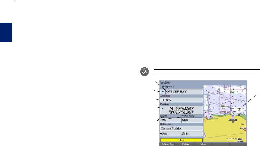
Reviewing and Editing Waypoints
After you create a waypoint, you can modify, review, rename, move, or delete it using the Review Waypoint Page. This page shows waypoint details, and a map window that you can pan or zoom in and out.
To access the Review Waypoint Page:
Use the ROCKER to highlight a waypoint on the Map Page, and press
ENTER.
To access the Review Waypoint Page from a waypoint list:
1.Press and hold ADJ/MENU to open the Main Menu. Use the ROCKER to highlight the Points tab, and then highlight a waypoint from the list.
2.Press ENTER to open the Review Waypoint Page.
NOTE: Additional information tabs do not appear in this mode.
Waypoint |
|
|
|
|
|
name |
|
Map |
Symbol |
|
|
|
window |
|
|
|
|
Comment |
|
|
Position |
|
|
Coordinates |
|
|
Depth/water |
|
|
temp |
|
|
|
|
|
Review Waypoint Page
16 |
GPSMAP 3006C/3010C Owner’s Manual |
Basic Operation > Reviewing and Editing Waypoints
To change the waypoint name:
1.Highlight the waypoint name field, and press ENTER.
2.Use the ROCKER to enter a new name, and press ENTER.
To change the waypoint symbol:
1.Highlight the waypoint symbol field to the left of the waypoint name, and press ENTER.
2.Use the ROCKER to select a different symbol, and press ENTER.
To access the map window on the Review Waypoint Page:
1.Press FCTN to highlight the map window. You can pan the map, change the map range, or use the map pointer to select a location.
Map window
Review Waypoint Page
2. Press FCTN to return to the left side of the Review Waypoint Page.
Waypoint Symbol List
Operation
Basic
To change the Comment, Position, Depth, or Water temp:
1.Highlight the Comment, Position, Depth, or Water temp field, and press
ENTER.
2.Use the ROCKER to enter new data, and press ENTER.
GPSMAP 3006C/3010C Owner’s Manual |
17 |
asBci peratO oni
Basic Operation > Reviewing and Editing Waypoints
Moving a Waypoint
You can modify a waypoint by moving or “projecting” the distance and bearing from its present location to a new location.
To move the waypoint on the map:
1.Press the Move Wpt soft key. The map window on the right side of the page is highlighted with the selected waypoint centered and highlighted on a map. The word MOVE appears below the pointer.
2.Use the ROCKER to move the waypoint to the new location. The distance and bearing from the waypoint’s current location appears in the upper-left corner of the map window.
3.Press ENTER to accept the new waypoint location.
Using Waypoint Lists
The Points tab on the Main Menu has two sub tabs, User and Proximity, which allow you to manage a large number of waypoints quickly and efficiently. The
Proximity sub tab also provides a continuously updated proximity waypoint alarm that you can use to define an alarm circle around submerged hazards or shallow waters.
To access the Points tab from the Main Menu:
1.Press and hold ADJ/MENU to open the Main Menu.
2.Use the ROCKER to highlight the Points tab, and highlight either the User or Proximity sub tab.
Sub tabs
4. Press FCTN to return to the left side of the Review Waypoint Page.
18 |
GPSMAP 3006C/3010C Owner’s Manual |

Basic Operation > Reviewing and Editing Waypoints
User Waypoints
The User sub tab on the Points tab shows a master list of all waypoints currently stored in memory. From the User sub tab, you can review, edit, rename, or delete individual waypoints, or delete all user waypoints. The number of available and used waypoints is shown at the bottom of the User sub tab. Stored waypoints are arranged in alphanumeric order.
To scroll through and review the waypoint list:
1.Use the ROCKER to highlight the Points tab on the Main Menu, and then highlight the User sub tab.
2.Press up or down on the ROCKER to scroll through the list of waypoints; press right or left on the ROCKER to scroll by page.
3.Press ENTER to review the highlighted waypoint on the Review Waypoint Page. See page 16 for information on reviewing and editing waypoints.
4.Press the Next soft key to return to the waypoint list. The next waypoint in the list is automatically highlighted.
Deleting Waypoints
The following soft keys are available when you highlight a waypoint on the User sub tab:
•New Waypoint—creates a new waypoint.
•Delete—deletes the selected waypoint from the list and from any route in which the waypoint was used.
•Del by Smbl—deletes waypoints that use the same symbol.
•Delete All—deletes all waypoints from the unit.
NOTE: When you delete a waypoint from the list, it cannot be recovered from the unit. Save important waypoints to a data card, or write them down.
To delete a single waypoint from the User sub tab:
1.Use the ROCKER to highlight the waypoint you want to delete, and then press the Delete Waypoint soft key. A confirmation message appears.
2.Highlight OK, and press ENTER to delete the selected waypoint.
To delete waypoints by symbol:
1.On the User sub tab, highlight the waypoint you want to delete.
2.Press the Delete By Symbol soft key.
3.Use the ROCKER to highlight the symbol of the waypoints you want to delete, and press ENTER.
4.Highlight OK, and press ENTER to delete the waypoints by symbol. Otherwise, highlight Cancel, and press ENTER to return to the User sub tab without deleting any waypoints.
To delete all user waypoints:
1.On the User sub tab, press the Delete All soft key.
2.Highlight OK, and press ENTER to delete all user waypoints.
Operation
Basic
GPSMAP 3006C/3010C Owner’s Manual |
19 |
asBci peratO oni
Basic Operation > Reviewing and Editing Waypoints
Proximity Waypoints
Use the Proximity sub tab to define an alarm circle around a stored waypoint. The alarm circle can help you avoid reefs, rocks, or restricted waters. You can add proximity alarms to a maximum of 10 waypoints or on-screen map items, with a maximum alarm radius of 99.99 nautical or statute miles, or kilometers.
If a proximity alarm circle overlaps an existing alarm circle, the message “Proximity Overlaps Another Proximity Waypoint” appears. Because the unit only alerts for one of the overlap points, use caution when navigating in these areas. If your boat enters a red proximity circle overlap, you are alerted only to the closest proximity waypoint.
Proximity circle |
Proximity waypoint |
|
|
|
|
To add a proximity waypoint:
1.Press the New Alarm soft key on the Proximity sub tab. The Find From Current Position Page appears.
2.Highlight a category, and press ENTER.
3.Use the ROCKER to highlight a waypoint or map item, and press ENTER. The Review Page appears for the selected waypoint or map item within a red circle.
4.Press the OK soft key. The Proximity sub tab appears with the Distance highlighted.
5.Press ENTER, and use the ROCKER to enter a proximity radius (up to 99.99 units).
6.Press ENTER when finished.
To turn proximity alarms on or off:
1.Use the ROCKER to highlight the field below Proximity Alarm on the
Proximity sub tab, and press ENTER.
2.Select ON or OFF, and press ENTER.
To clear one or all proximity waypoints from the list:
1.Use the ROCKER to highlight the proximity waypoint you want to clear.
2.To clear a single alarm, press the Delete soft key. OR
To clear all proximity waypoints, press the Delete All soft key. A confirmation message appears.
3.Press the OK soft key to delete the proximity waypoint. Otherwise, press the Cancel soft key, or press QUIT to cancel.
20 |
GPSMAP 3006C/3010C Owner’s Manual |
Basic Operation > Navigating to a Destination
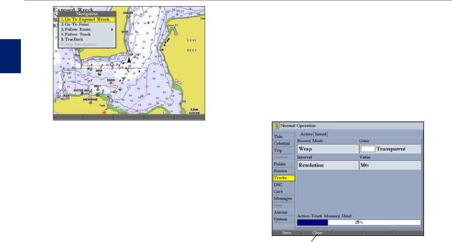
Navigating to a Destination
Using the NAV key, the GPSMAP 3006C/3010C provides four ways to navigate to a destination: Go To Point, Follow Track, TracBack, and Follow Route. When you are actively navigating, you see a straight line on the Map Page that always runs from your current location to the destination. The easiest method for selecting a destination is the Go To function, which allows you to select a destination point, and then set a direct course to it from your present location. If you highlight a point on a list or the map and press NAV, Go To <point name>
appears in addition to Go To Point. The Go To function can be accessed from any list of points or from the map display.
Current location |
Destination |
|
|
|
|
Navigating to a Destination
To Go To a point:
1.Press NAV.
2.Highlight Go To Point, and press ENTER. The Find From Current Position Page opens.
3.Highlight Waypoints, and press ENTER. (You can also choose to go to other points from this list, such as cities or tide stations.)
4.Select a waypoint, and press ENTER to open the Review Waypoint Page for the selected waypoint.
5.Press the Go To soft key to begin navigation. A magenta line appears on the map showing the course from your present location to the
Go To point.
To stop navigation:
1.Press NAV.
2.Highlight Stop Navigation, and press ENTER.
Selecting a Map Item Go To Destination
A Go To can be used to select one of three items from the map—an existing waypoint, on-screen map items such as rivers, cities, navaids, or a new map point. If you select a map item as the Go To destination, the GPSMAP 3006C/3010C automatically uses the name of the map item, but the point is not stored in
the waypoint list. If you select a new map point (non-map item) as the Go To destination, the GPSMAP 3006C/3010C automatically creates a waypoint named MAP at the pointer location.
To Go To an existing waypoint or map item from the map:
1.Use the ROCKER to highlight the waypoint or map item to which you want to navigate on the Map Page, and press NAV.
2.On the Navigation Menu, highlight Go To <waypoint name>, and press
ENTER.
Operation
Basic
GPSMAP 3006C/3010C Owner’s Manual |
21 |
asBci peratO oni
Basic Operation > Navigating to a Destination
To Go To a new map point (non-map item) from the map:
1.Use the ROCKER to move the pointer to the location you want to go to, and press NAV.
2.With Go To MAP Point highlighted, press ENTER.
To stop navigation:
1.Press NAV.
2.Highlight Stop Navigation, and press ENTER.
Follow Track and TracBack Navigation
A track is an electronic breadcrumb trail recording or history of your path. The track currently being recorded is the “active” track. An active track can be stored or saved in the unit. Both the Follow Track and TracBack options navigate in the same way. Follow Track uses stored or “saved” tracks; TracBack uses your current or “active” track.
TracBack allows you to retrace your path using the track log stored in the receiver’s memory, which eliminates the need to store waypoints along the way. TracBack routes are created by reducing your track log into a route and activating an inverted route. When active, a TracBack route leads you through your stored track log points, so it is a good idea to clear the existing track log before you start your current trip.
To clear the track log:
1.Press and hold ADJ/MENU to open the Main Menu.
2.Using the ROCKER, highlight the Tracks tab, and then highlight the Active sub tab.
3.Press the Clear soft key. A confirmation message appears.
4.Press the OK soft key to clear the track log.
Clear soft key
22 |
GPSMAP 3006C/3010C Owner’s Manual |
 Loading...