


GPS 48
PERSONAL
NAVIGATORTM
O W N E R ’ S
M A N U A L
& R E F E R E N C E

Software Version 4.55 or above
© 1998-1999 GARMIN Corporation
1200 E. 151st Street, Olathe, Kansas 66062 USA
Tel: 913-397-8200 Fax: 913-397-8282
GARMIN (Europe) Ltd.
Unit 5, The Quadrangle, Abbey Park, Romsey, Hampshire SO51 9AQ UK
Tel: 011-44-1794-519944 Fax: 011-44-1794-519222
GARMIN (Asia) Corp.
No. 68, Jangshu 2nd Rd., Shijr, Taipei County, Taiwan
Tel: 011-886-2-2642-9199 Fax: 011-886-2-2642-9099
Web Site Address: www.garmin.com
All rights reserved. Except as expressly provided herein, no part of this manual may be reproduced, copied, transmitted, disseminated, downloaded or stored in any storage medium, for any purpose without prior written consent of GARMIN Corporation.
GARMIN Corporation hereby grants permission to download a single copy of this manual onto a hard drive or other eletronic storage medium to be viewed for personal use, provided that such electronic or printed copy of this manual contains the complete text of this copyright notice and provided further that any unauthorized commercial distribution of this manual is strictly prohibited.
Information in this manual is subject to change without notice. GARMIN Corporation reserves the right to change or improve its products and to make changes in the content without obligation to notify any person or organization of such changes. Visit the GARMIN website (www.garmin.com) for current updates and supplemental information concerning the use and operation of this and other GARMIN products.
GARMIN, Personal Navigator, AutoLocate, TracBack, and PhaseTrac12 are all trademarks of GARMIN Corporation and may not be used without the express permission of GARMIN Corporation.
December 1999 - Part Number 190-00141-00 Rev. B - Printed in Taiwan

GPS 48
OWNER’S
MANUAL
INTRODUCTION
Packing List
Thank you for choosing the GARMIN GPS 48 —the smallest, easiest- to-use GPS navigator for outdoor use! The GPS 48 represents GARMIN’s continuing commitment to provide quality navigation information in a versatile and user-friendly flexible design you’ll enjoy for years. To get the most from your new GPS, take the time to read through the owner’s manual in order to understand the operating features of the GPS 48. This manual is organized into four sections for your convenience:
Introduction gives a quick overview of the manual and contains the table of contents and the glossary of navigational terms.
Getting Started introduces you to the basic features of the unit and provides a quick-start orientation to the GPS 48.
Reference provides details about the advanced features and operations of the GPS 48 by topic.
The Appendix section contains initialization instructions and items with multiple listings, such as map datums, time offsets, and the index.
Before getting started with your GPS, check to see that your GARMIN GPS 48 package includes the following items. If you are missing any parts, please contact your dealer immediately.
Standard Package: |
|
• GPS 48 Unit |
• Owner’s Manual |
• Wrist Strap |
• Quick Reference Guide |
• Carrying Case |
• 4 AA Batteries |
See your GARMIN dealer for accessories including our PC kit, swivel mounts, external antennas, and power/data cables.
We hope the GPS 48 will meet all of your navigation needs and know it will become a valuable part of your outdoor gear.
i

INTRODUCTION
Caution
The GPS system is operated by the government of the United States, which is solely responsible for its accuracy and maintenance. The system is subject to changes which could affect the accuracy and performance of all GPS equipment. Although the GPS 48 is a precision electronic NAVigation AID (NAVAID), any NAVAID can be misused or misinterpreted and, therefore, become unsafe.
Use the GPS 48 at your own risk. To reduce the risk of unsafe operation, carefully review and understand all aspects of this Operator’s Manual and thoroughly practice operation using the simulator mode prior to actual use. When in actual use, carefully compare indications from the GPS 48 to all available navigation sources including the information from other NAVAIDs, visual sightings, maps, etc. For safety, always resolve any discrepancies before continuing navigation.
NOTE: This device meets requirements for Part 15 of the FCC limits for Class B digital devices for home or office use. It has been tested for compliance with all necessary FCC standards. This equipment generates, uses, and can radiate radio frequency energy and, if not installed and used in accordance with the instructions, may cause harmful interference to radio communications. However, there is no guarantee that interference will not occur in a particular installation. If this equipment does cause harmful interference to other equipment, which can be determined by turning the equipment off and on, the user is encouraged to try to correct the interference by relocating the equipment or connecting the equipment to a different circuit than the affected equipment. Consult an authorized dealer or other qualified service technician for additional help if these remedies do not correct the problem. Operation is subject to the following conditions: (1) This device cannot cause harmful interference, and (2) this device must accept any interference received, including interference that may cause undesired operation. The GPS 48 does not contain any user-serviceable parts. Repairs should only be made by an authorized service center. Unauthorized repairs or modifications could void your warranty and your authority to operate this device under Part 15 regulations.
ii

|
|
|
|
|
INTRODUCTION |
|
|
|
|
|
Table of |
|
|
|
|
|
Contents |
SECTION ONE |
Introduction |
|
|||
Glossary . . . . . . . . . . . . . . . . . . . . . . . . . . . . . . . . . . . . . . . . . . . . .2-3 |
|||||
Navigation Basics & Key Pad Usage & Data Entry . . . . . . . . . . . . . . .4-5 |
|||||
SECTION TWO |
Getting Started |
|
|||
Initializing for First Time Use . . . . . . . . . . . . . . . . . . . . . . . . . . . . . .6-7 |
|||||
Primary Page Overview |
. . . . . . . . . . . . . . . . . . . . . . . . . . . . . . . . . .8-9 |
||||
Power On & Marking a Position . . . . . . . . . . . . . . . . . . . . . . . . . . . .10 |
|||||
Position Page, Map Basics, & Going To A Waypoint . . . . . . . . . . . . . .11 |
|||||
Compass Page & Cancelling A GOTO . . . . . . . . . . . . . . . . . . . . . . . .12 |
|||||
Clearing the Map Display, Screen Contrast, & Power Off . . . . . . . . . . .13 |
|||||
SECTION THREE |
Reference |
|
|||
Satellite Page |
. . . . . . . . . . . . . . . . . . . . . . . . . . . . . . . . . . . . . . . .14-15 |
||||
Battery Level Indicator, Backlighting, and Emergency Erase . . . . . . . . .16 |
|||||
Position Page & User Selectable Fields . . . . . . . . . . . . . . . . . . . . .17-18 |
|||||
Map Page & Marine Database . . . . . . . . . . . . . . . . . . . . . . . . . . . .19-21 |
|||||
Map Page, Zooming, Panning & Configuring . . . . . . . . . . . . . . . . .22-23 |
|||||
Map Page, Track Log, City, & Navaid Setup . . . . . . . . . . . . . . . . . .24-27 |
|||||
Using the Highway & Compass Pages . . . . . . . . . . . . . . . . . . . . . .28-31 |
|||||
Marking a Position & Position Averaging Function . . . . . . . . . . . . . . .32 |
|||||
Waypoint Pages & Managing Waypoints |
. . . . . . . . . . . . . . . . . . . .33-37 |
||||
Selecting a GOTO Destination & Man Overboard . . . . . . . . . . . . . . . .38 |
|||||
TrackBack Navigation . . . . . . . . . . . . . . . . . . . . . . . . . . . . . . . . . .39-40 |
|||||
Creating & Using Routes |
. . . . . . . . . . . . . . . . . . . . . . . . . . . . . . .41-45 |
||||
Menu Page & Distance/Sun Calculation |
. . . . . . . . . . . . . . . . . . . . . . .46 |
||||
System Setup |
. . . . . . . . . . . . . . . . . . . . . . . . . . . . . . . . . . . . . . . .46-48 |
||||
Navigation Setup |
. . . . . . . . . . . . . . . . . . . . . . . . . . . . . . . . . . . . .49-51 |
||||
Interface Setup & DGPS Interface . . . . . . . . . . . . . . . . . . . . . . . . .52-53 |
|||||
Alarms Setup |
. . . . . . . . . . . . . . . . . . . . . . . . . . . . . . . . . . . . . . . . . .54 |
||||
Find City . . . . . . . . . . . . . . . . . . . . . . . . . . . . . . . . . . . . . . . . . . . . .55 |
|||||
Navigation Simulator . . . . . . . . . . . . . . . . . . . . . . . . . . . . . . . . . . . . .56 |
|||||
SECTION FOUR |
|
Appendices |
|
||
Appendix A––Specifications & Wiring . . . . . . . . . . . . . . . . . . . . .57-60 |
|||||
Appendix B—Messages and Time Offsets |
. . . . . . . . . . . . . . . . . . .61-62 |
||||
Appendix C—Map Datums . . . . . . . . . . . . . . . . . . . . . . . . . . . . . .63-64 |
|||||
Appendix D—Navaid Descriptions . . . . . . . . . . . . . . . . . . . . . . . . . . .65 |
|||||
Appendix E—Index |
. . . . . . . . . . . . . . . . . . . . . . . . . . . . . . . . . . .66-68 |
||||
|
|
|
|
|
1 |

INTRODUCTION
Glossary
The GPS 48 is a powerful navigation tool that can guide you anywhere in the world. To better understand its operation and capabilities, it may be helpful to review the basic terms and concepts briefly explained below.
Other navigation and GPS definitions used in the manual are defined in the appropriate reference sections of the manual.
Almanac Data
Satellite constellation information (including location and health of satellites) that is transmitted to your receiver from every GPS satellite. Almanac data must be acquired before GPS navigation can begin.
Bearing
The compass direction from your position to a destination.
Course Made Good (CMG)
The bearing from the “active from” position (your starting point) to your present position.
Course Deviation Indicator (CDI)
The sca;e on the highway page indicating amount of off corse deviation.
Course To Steer (CTS)
The bearing giving the most efficient direction to your destination.
Crosstrack Error (XTK)
The distance you are off a desired course in either direction.
Desired Track (DTK)
The compass course between the “from” and “to” waypoints.
Differential GPS (DGPS)
An extension of the GPS system that uses land-based radio beacons to transmit position corrections to GPS receivers.
Estimated Time of Arrival (ETA)
The time of day of your arrival at a destination.
2

INTRODUCTION
Glossary
Estimated Time Enroute (ETE)
The time left to your destination at your present speed.
Grid
Coordinate system that projects the earth on a flat surface, using square zones for position measurements. UTM/UPS and Maidenhead formats are grid systems.
Ground Speed (SPD)
The velocity you are traveling relative to a ground position.
Latitude
The north/south measurement of position perpendicular to the earth’s polar axis.
Longitude
An east/west measurement of position in relation to the Prime Meridian, an imaginary circle that passes through the north and south poles.
Navigation
The process of traveling from one place to another and knowing where you are in relation to your desired course.
Position
An exact, unique location based on a geographic coordinate system.
Track (TRK)
The direction of movement relative to a ground position.
Universal Transverse Mercator (UTM)
A grid coordinate system that projects global sections onto a flat surface to measure position in specific zones.
Velocity Made Good (VMG)
The speed you are traveling in the direction of the destination.
Waypoint
A specific location saved in the receiver’s memory.
3
INTRODUCTION
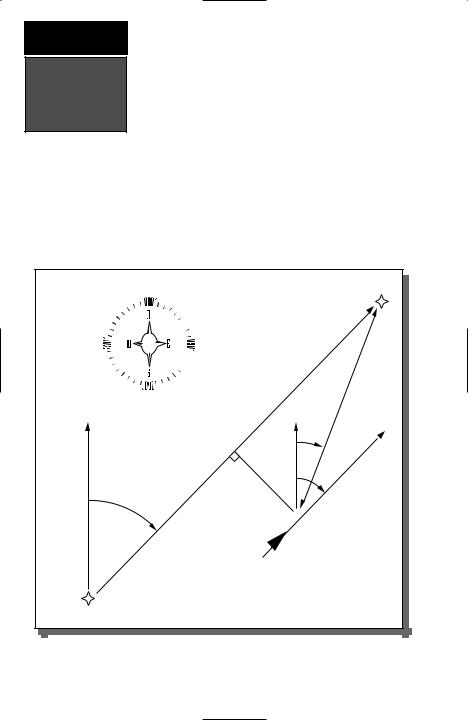
Navigation
Basics
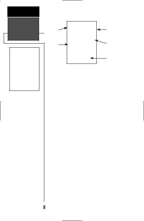
The GPS 48 provides steering guidance and navigation information using degrees, a measurement measured in a clockwise direction from a north reference. North is described as 000º, east as 090º, south as 180º, and west as 270º. The diagram and compass rose below provide a graphic illustration of the navigation terms used by the GPS 48. More information on basic navigation and GPS are available at your local library or bookstore.
|
|
|
|
|
|
“ACTIVE TO” |
|
|
|
|
|
|
WAYPOINT |
NORTH |
|
“ACTIVE |
LEG” |
NORTH |
DISTANCE |
|
|
|
|
||||
|
|
|
|
|
|
|
|
|
|
|
BRG |
|
|
|
|
|
|
|
GROUND |
SPEED |
|
|
CROSSTRACK |
TRK |
|
||
|
|
|
|
|
||
|
DTK |
|
ERROR |
|
|
|
|
|
|
|
|
|
|
“ACTIVE FROM” |
|
|
|
|
|
|
WAYPOINT |
|
|
|
|
|
|
4
B |
Turns the unit on and off and |
activates screen backlighting. |
|
|
Scrolls through the main data |
Ppages in sequence and returns display from a submenu page to a primary page.
M |
Captures a position and dis- |
plays the mark position page. |
|
|
Displays GOTO page with |
Gthe waypoint highlighted for GOTO operation. Pressing GOTO twice activates MOB.
Confirms data entry and
Eactivates highlighted fields to allow data entry.
Returns display to a previous Q page, or restores a data field’s
previous value.
Selects alphanumerical UD characters and menu choices
and moves the field highlight from field to field.
Moves the selected character L R field and moves the field
highlight from field to field.
INTRODUCTION
Keypad Usage &
Data Entry
DATA ENTRY
The arrow keypad is used for all data entry. Use the U and D keys to select letters, numbers, and menu options; use the Land Rkeys to move the cursor forward or backward along the line. Press E to begin entering data, and to confirm your entry.
5
GETTING
STARTED
Initializing the
Receiver
Hold the receiver parallel to the ground and rotate the antenna perpendicular to the receiver.
Welcome Page
Initializing Your GPS 48 for First-Time Use
The GPS 48 does not require initialization under normal day-to-day use. However, initialization may reduce the time it takes to compute a position fix after one of the following events:
•After memory loss
•When the receiver has been moved more than 500 miles with the power off.
Additionally, it may be necessary to initialize the unit the first time you use it, if it does not acquire a fix in a few minutes.
The receiver is shipped from the factory in AutoLocate™ mode, which enables the GPS 48 to determine its location anywhere in the world. Another method is the graphic initialization described below, which usually provides a fix in a few minutes.
To turn the GPS 48 on:
1. Press and hold Buntil the receiver turns on.
The welcome page is displayed while the unit conducts a self test, followed by a warning page.
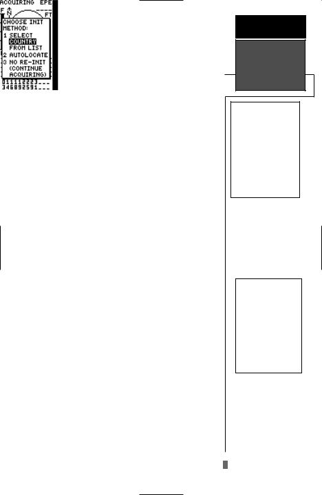
Once testing is complete, the warning page is replaced by the Satellite Page, with the EZinit prompt ready for you to select one of two initialization methods:
•Select Country––allows you to initialize the receiver by selecting your present position from a list of countries in the GPS 48’s internal database. This method usually provides a position fix in a few minutes.
•AutolocateTM ––allows the GPS 48 to initialize itself and calculate a position fix without knowing your present position. This usually provides a position fix in 3-5 minutes.
The EZinit prompt can be activated from the satellite page by pressing the Ekey if the unit has not acquired satellites.
Note: If the EZinit prompt appears after you have initialized the receiver (due to the antenna’s view of satellites being obstructed), highlight the ‘NO RE-INIT’ selection with the arrow keypad and press E.
6
To initialize the receiver:
1.If the ‘COUNTRY’ option is not highlighted, press the Dkey repeatedly to move the field highlight to the ‘COUNTRY’ option.
2.Press the Ekey.
3.Use theDkey to scroll through the list options until the country of your present location appears. If the country you’re in is not listed, select another country within 500 miles of your present
position.
4.Use theUkey to highlight the country/state/region you’re in.
5.Press Eto finish.
The GPS 48 now begins searching for the appropriate satellites for your location and should acquire a position within 3-5 minutes. You can verify that you have acquired a position by watching the Satellite Page transition to the Position Page (provided you haven’t pressed any other buttons) or by looking for a ‘2D NAV’ or ‘3D NAV’ status at the top-left corner of the Satellite Page.
Initialization Troubleshooting
If you have trouble initializing the receiver or acquiring a position, check the following:
• Does the unit have a clear view of the sky?
If there are large buildings or mountains nearby, or if there is heavy tree cover, the receiver may not be receiving enough satellite signals to calculate a position.
•Have you selected the right country/state/region from the EZinit list?
Check for the correct approximate lat/lon on the Position Page, or reselect the appropriate country from the list to restart the initialization.
•Have you moved more than 500 miles from the last calculated position with the receiver off?
Reinitialize the receiver, selecting the country/state/ region of your new location from the EZinit list.
Your unit should now be initialized.
GETTING
STARTED
Initializing the
Receiver
The EZinit prompt will automatically appear if the receiver needs to be initialized. The prompt may also appear during normal use if the antenna is shaded or the unit is indoors.
Use the arrow keypad to highlight the country and region or state (if necessary) of your present position from the list and press ENTER. If the country is not listed, select the closest country instead.
7
GETTING
STARTED
Primary Pages
Primary Pages
Before we start the tour, let’s briefly look at the five primary information pages used for the GPS 48. Switch between pages by pressing either the Qor Jkeys.
J

 Q
Q
Satellite Page
The Satellite Page will allow you to monitor satellite signal reception and strength.
Position Page
Satellite Page
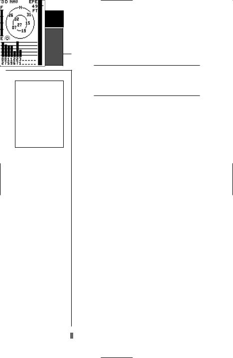
The Satellite Page shows satellite positions and signal strength. Satellite positions are displayed using two circles and a center point. The outer circle shows satellites on level with the horizon; the inner circle is 45º above the horizon; and the center point represents satellites directly overhead. Knowing satellite positions will show you the direction of any blocked signals.
The bottom of the page contains a row of signal strength bars corresponding to each satellite being used.
Position Page
The Position Page shows you where you are, what direction you’re heading and how fast you’re going.
The top of the page contains a compass tape which is a graphic representation of your heading. Your track and#speed are indicated immediately below.
!
The rest of the page shows your current position in three dimensions: latitude, longitude, and altitude. A trip odometer and 12/24-hour clock are also provided.
8
Map Page
The Map Page acts as a window. It allows you to view your position, the “path” you have traveled over, and nearby navaids, cities and waypoints.
A diamond icon in the center of the screen represents your current position. As you move, you will see a thin line - called a track log - appear along the path you have just covered.
The GPS 48 contains a built–in marine database that displays city locations and nautical navaids on the moving map. The database is covered on pages 21-22.
The bottom corners of the map will always display your current track and speed. When going to a waypoint, highlighting an on-screen waypoint, or using the panning target crosshair, the corresponding distance and bearing are shown at the top corners of the map. The top of the screen contains the zoom, pan, and configuration fields.
Navigation Page
A navigation page gives you steering guidance when going to a waypoint. The GPS 48 has two navigation page choices: the Compass Page and the Highway Page. The Compass Page is the default and briefly explained here. The Highway Page is covered on pages 28 and 31.
The Compass Page shows the destination waypoint at the top of the page with the bearing (BRG) and distance (DST) to the waypoint shown below. The center of the page contains a compass ring and arrow to show you the direction of the waypoint from the direction you are moving. The bottom of the page gives your track (TRK), speed (SPD), and a selectable field for estimated time to arrival (ETA), estimated time enroute (ETE), course to steer (CTS), crosstrack error, (XTK), velocity made good (VMG), or turn bearing (TRN).
Menu Page
The last primary page is the Menu Page. The Menu Page gives you access to the GPS 48’s waypoint management, route, track log, and setup features through a list of submenus.
GETTING
STARTED
Primary Pages
The Map Page shows your progress on a moving map plotter and gives a bird’s–eye–view of surrounding naviads, cities and waypoints.
The Compass Page is the default navigation page and will show you the way to the waypoint from the direction you are moving.
9
GETTING
STARTED
Power On &
Marking a
Position
The Welcome Page will be shown while the unit conducts a self test.
Press the UP arrow to move forward through the alphabet or numbers and the DOWN arrow to move backward.
Getting Started Tour
Now that you’ve seen the primary pages, let’s get started by taking a simple tour to show you the basics about using your GPS 48. The tour assumes that your unit has been turned on, initialized, and that none of the factory settings (units of measure, selectable fields, etc.) have been changed. If these settings have been changed, the pictures and descriptions you see in this manual may not match what you see on your screen.
Turning the GPS 48 On
1. Press Buntil the receiver turns on.
The welcome page will appear while the unit conducts a self test. Once testing is complete, the Satellite Page will appear. When sufficient satellite signals have been acquired, the Satellite Page will be replaced by the Position Page. If your unit acquires a position rapidly it will skip the Satellite Page.
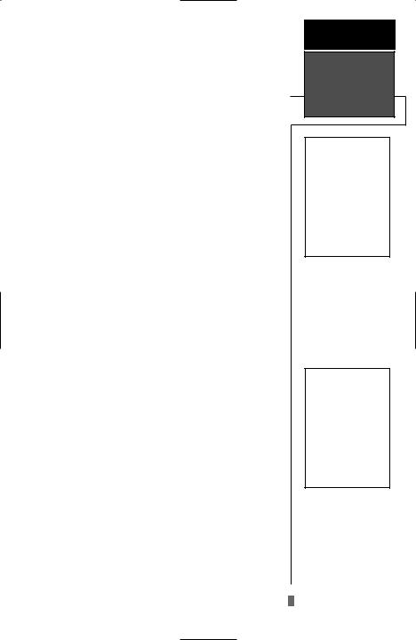
Marking a Position
GPS is really about marking and going to places called waypoints. Before we can use our GPS 48 to guide us somewhere, we have to mark a position as a waypoint. (Your GPS 48 can hold up to 500 waypoints.)
To mark your present position:
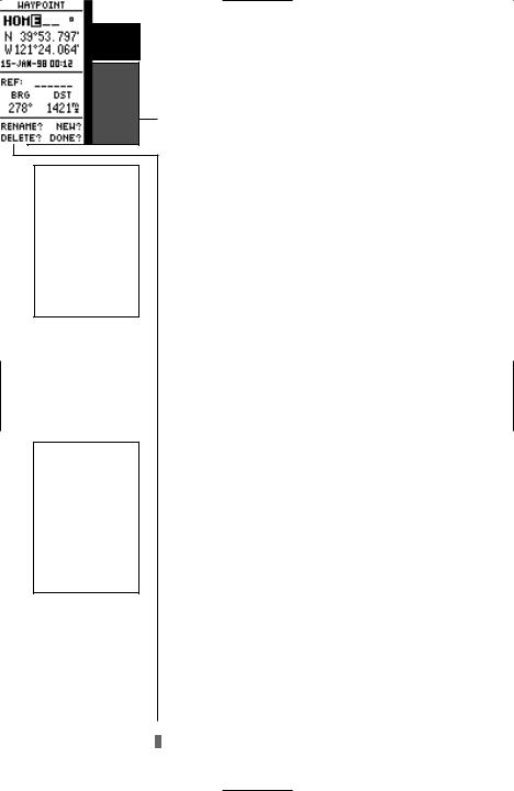
1.Press the Mkey. The mark position page will appear, with a default three-digit name for the new waypoint in the upper-left portion of the page.
To rename the waypoint:
1.Highlight the name field, and press E.
2.Enter the waypoint name ‘HOME’, and press E. (See pg. 9 for data entry.) The waypoint symbol field will become highlighted.
Each waypoint may also be assigned a custom waypoint symbol for easy waypoint recognition on the map.
To change the waypoint symbol:
1.Highlight the waypoint symbol field, and press E.
2.Select the house symbol, and press E.
3.Move the cursor to the ‘DONE?’ prompt, and press
E.
10
Using the Position Page
Walk at a brisk pace for 3-4 minutes and watch the Position Page. The direction you are moving (track), your speed, trip distance, and altitude are shown on the upper half of the screen. The latitude and longitude of your position are displayed in the middle of the page, with the time of day shown below.
Let’s continue by moving to the next page:
1. Press P.
Map Page
The next page is the Map Page. To ensure we can see our entire trip on the map, lets change the map scale from .2nm (default) to 1.2nm.
1.Use the arrow keys to highlight the ‘ZM’ field at the top left of the Map Page and press E.
2.Press the Uarrow until ‘1nm’ is shown and press
E.
The Map Page shows your present position as a diamond icon in the center of the map. The house symbol labeled ‘HOME’ is the waypoint you created and the line connecting the two is your track log.
1.Now turn approximately 90º to your right and continue walking for another 2-3 minutes. Notice how the display changes, always keeping the direction you are moving at the top of the map .
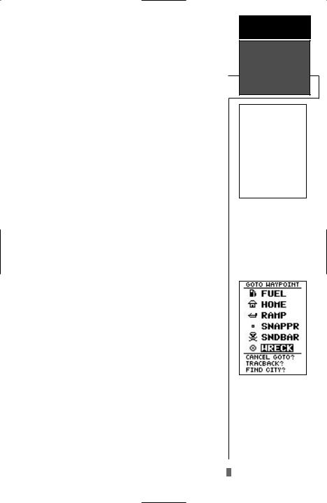
Going to a Waypoint
Once you’ve stored a waypoint in memory, you may return to it by performing a GOTO. A GOTO is a straight-line course from your present position to the destination you’ve selected. Let’s navigate back to our starting position, the HOME waypoint.
To select a GOTO destination:
1.Press G.
2.Highlight the ‘HOME’ waypoint, and press E.
You’ll notice that you’ll automatically return to the Map Page, and a straight line will connect your current position to the position of the GOTO waypoint.
Let’s continue by moving to the next page:
GETTING
STARTED
Map Page &
Going to a
Waypoint
The Map Page displays your present position as a diamond icon and provides a real time graphic “breadcrumb” display of your track right on the screen.
The GOTO waypoint page allows you to select a destination from a list of all available waypoints in the GPS 48’s memory.
1. Press P. |
11 |
|

GETTING
STARTED
Highway Page &
Cancelling a
GOTO
The GPS48 will also provide steering guidance with a Graphic Compass display.
Once a GOTO is activated, the GPS 48 provides steering guidance until the GOTO is canceled. To cancel a GOTO, highlight the cancel prompt at the bottom of the page and press ENTER.
12
Highway Page
Bearing to |
Distance to |
|
Waypoint |
Waypoint |
|
Track Over |
Speed Over |
|
Ground |
||
Ground |
||
|
||
Destination |
CDI Scale |
|
Waypoint |
||
Graphic |
User Selectable |
|
Highway |
Field |
|
|
The GPS 48’s Highway Page provides graphic steering guidance to a destination waypoint, with emphasis on the straight-line desired course, the distance and direction you are off course.
As you head toward your destination, the middle of the screen provides visual guidance to your waypoint on a moving graphic “highway.”
Your present position is represented by the diamond in the center of the CDI scale. The line down the middle of the highway represents your desired track. As you navigate toward a waypoint, the highway will actually move—indicating the direction you’re off course—rela- tive to the position diamond on the CDI scale. To stay on course, simply steer in toward the center of the highway.
To select the Compass Page
1. From the Highway Page, press Etwice.
The Compass Page will now become the displayed navigation page. This page provides a directional pointer to your destination, by using a rotating compass display to show direction of travel. It provides better steering guidance at slower speeds with many directional changes.
Cancelling a GOTO
If you decide to stop navigating to the active waypoint, all you have to do is cancel the GOTO.
To cancel an active GOTO:
1.Press the Gkey.
2.Use the arrow keypad to move the field highlight to the
‘CANCEL GOTO’ prompt at the bottom of the page and press E.
Clearing a Cluttered Map Display
After you’ve used the GPS 48 for a few trips, you may find that your map display has become a bit messy from keeping track of your every move. For practice, let’s clean up the screen by clearing the track log (the plot points left on the Map Page) we’ve just created during the Getting Started tour.
1.Press Por Quntil the Map Page appears.
2.Highlight the ‘CFG’ field and press E.
3.Highlight ‘Track Setup’ and press E.
4.Highlight the ‘CLEAR LOG?’ option and press E. The clear log confirmation page will appear.
5.Use the Lkey to highlight the ‘Yes’ prompt.
6.Press Eto finish.
Adjusting Screen Contrast
You can access the GPS 48’s contrast feature from the
Satellite Page.
To adjust the screen contrast:
1.Press Por Quntil the Satellite Page appears.
2.Press Lor Rto adjust the level of contrast, and press
E.
Screen Backlighting
Three levels of screen backlighting are available for nighttime use. Activate backlighting by pressing the B key briefly. To change the level of backlighting, press the Bkey repeatatly until the desired level is of backlight is selected. Backlighting will remain on for the time specified on the system setup page (See page 48) or until turned off.
Turning the Receiver Off
You’ve now gone through the basic operation of your new GPS receiver and probably know a little more than you think about how it works. We encourage you to experiment with the GPS 48 until it becomes an extension of your own navigation skills. If you encounter any problems using the unit or want to take advantage of the GPS 48’s more advanced features, turn to the reference section.
To turn the GPS 48 off:
GETTING
STARTED
Clearing the
Map, Contrast,
& Power Off
Highlight the ‘CLEAR LOG?’ prompt and press ENTER to clear the track log.
Pressing the LEFT or RIGHT arrows from the Satellite Page will automatically activate the screen contrast bar.
1. Press and hold the Bkey for 3 seconds.
13
REFERENCE
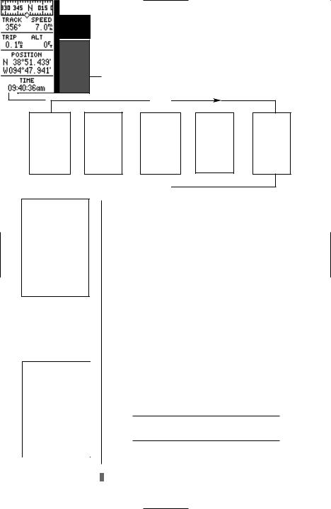
Satellite Page
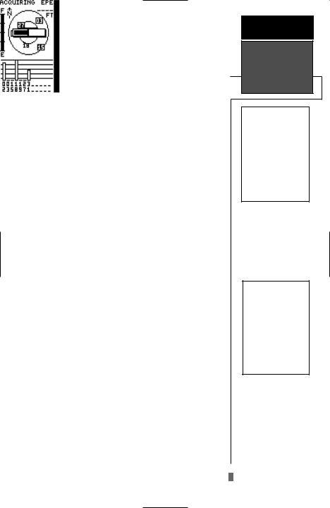
The GPS 48 Satellite Page will help you determine which satellites are in view, and whether or not any satellites are being “shaded” or blocked from receiving satellite signals (See satellite 02 above).
By periodically monitoring the signal strength bars at the bottom of the page and the north up sky view, you will be able to see how moving to another area with a clearer view of the sky will improve satellite reception and speed up signal acquisition.
14
Satellite Page
Status |
Estimated |
Field |
Position Error |
Battery |
Skyview |
Indicator |
Display |
|
Signal Strength |
|
Indicators |
The GPS 48’s Satellite Page displays the status of various receiver functions. The status information will help you understand what the GPS 48 is doing at any given time, and will tell you whether or not the receiver has calculated a position fix.
Sky View and Signal Strength Bars
The sky view and signal strength bars give you an indication of what satellites are visible to the receiver, whether or not they are being used to calculate a position fix, and the signal quality. The satellite sky view shows a bird’s-eye-view of the position of each available satellite relative to the unit’s last known position. The outer circle represents the horizon (north up); the inner circle is 45º above the horizon; and the center point is directly overhead. You can use the sky view to help determine if any satellites are being blocked, and whether you have a current position fix (indicated by a ‘2D NAV’ or ‘3D NAV’ in the status field). You can also set the sky view to a track up configuration by changing the ‘orientation’ option on the Map Page. (See pg. 24 for setup instructions.)
While the receiver is looking for satellites the satellite number will be highlighted in the sky view. When the receiver locates and begins satellite reception, the satellite number will no longer be highlighted and a hollow strength indicator will be displayed at the bottom of the page. After the receiver has gathered the satellite information and can use the satellite for navigation the strength indicator bar will become solid. As soon as the GPS 48 has gathered enough satellites to calculate a position the status field will indicate a 2D or 3D fix.
Receiver Status
Receiver status is indicated at the top left of the page, with the current horizontal accuracy (estimated position error, in feet or meters) at the top right. The status will be shown as one of the following conditions:
Searching— the GPS 48 is looking for any available satellites in view.
AutoLocate— the GPS 48 is initializing and collecting new almanac data. This process can take 5 minutes, depending on the satellites currently in view.
Acquiring— the receiver is collecting data from available satellites, but has not collected enough data to calculate a 2D fix.
2D Nav (2D Navigation)— at least three satellites with good geometry have been acquired and a 2-dimensional position fix (latitude and longitude) is being calculated. ‘2D Diff’ will appear when you are receiving DGPS corrections in 2D mode.
3D Nav (3D Navigation)— at least four satellites with good geometry have been acquired, and your position is now being calculated in latitude, longitude and altitude. ‘3D Diff’ will appear when you are receiving DGPS corrections in 3D mode.
Poor Cvg (Poor GPS Coverage)— the receiver isn’t tracking enough satellites for a 2D or 3D fix due to bad satellite geometry.
Not Usable— the receiver is unusable, possibly due to incorrect initialization or abnormal satellite conditions. Turn the unit off and back on to reset, and reinitialize the receiver if necessary.
Simulator— the receiver is in simulator mode.
EZinit Option Prompt
The Satellite Page also provides access to the EZinit prompt whenever a position fix has not been calculated. (The unit must be in searching, AutoLocate, acquiring, simulator, or poor coverage mode.) This allows you to reinitialize the unit, and is useful if you have traveled over 500 miles with the receiver off. (The EZinit prompt will automatically appear if the receiver needs to be initialized. The prompt may also appear during normal use if the antenna is shaded or the unit is indoors.)
REFERENCE
Receiver Status
& EZinit
The signal strength bars at the bottom of the page will not appear until the GPS 48 has found the satellites indicated at the bottom of the screen.
If you travel over 500 miles with the receiver off, you may reinitialize the unit to your new position by using the EZinit feature. To access EZinit press ENTER from the Satellite Status Page before any satellites are acquired.
15
REFERENCE
Battery Level,
Backlighting &
 Emergency Erase
When backlighting is on, a bulb icon will appear on the Satellite Page.
Use the icon to determine if backlighting is turned on during daylight hours.
Upon activating the Emergency Erase Function, you will be asked to confirm your decision.
Battery Level Indicator
The Satellite Page also features a battery level indicator, located to the left of the sky view, which displays the strength of the unit’s batteries. The battery indicator will not appear if the receiver is using external power.
The battery level indicator is calibrated for alkaline batteries. Voltage differences will display
! |
Ni-Cad and lithium batteries differently. No |
# other receiver functions are affected. |
|
The GPS 48 features an internal lithium battery that will maintain the unit’s memory when the receiver is not running off batteries or external power.
Backlighting Bulb Icon
The GPS 48 features full-screen backlighting with three selectable levels of brightness. To activate the backlight, press the Bkey briefly. To increase the brightness, repeatedly press the Bkey. The backlight will remain on until cycled off or the backlight timeout setting has been reached (see page 48).
Note: A bulb icon will appear on the Satellite Page when backlighting is turned on.
Emergency Erase Function
You may erase the GPS 48’s memory in four quick steps. This will cause all stored data to be deleted, including: routes, waypoints, and the track log.
To erase all stored data:
1.Ensure that the GPS 48 is turned off.
2.While holding down the Mkey, hold down the B key to turn the unit on. A warning message will appear with “Yes?” highlighted, and ask you to confirm your selection.
3.If you do not wish to erase all stored data, select ‘No?’ by pressing Rand Eto cancel the emergency erase.
4.If you do wish to complete the emergency erase, press Eto confirm.
16
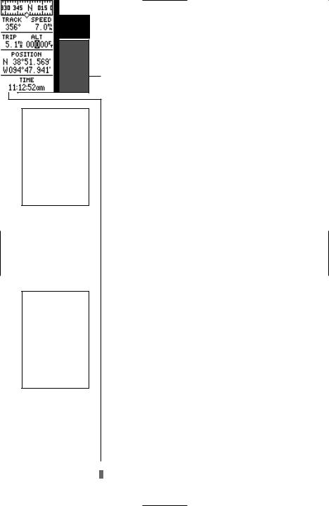
Position Page
The second page in the GPS 48’s primary page sequence is the Position Page. This page shows you where you are, what direction you’re heading, and how fast you’re going, and it’s most useful when you are traveling without an active destination waypoint. The graphic heading display at the top of the page indicates the direction you’re heading (while you’re moving).
Directly below this display are the track, speed, and trip odometer and altitude fields (default). Track is the compass direction representing your course over the ground, and speed is how fast you’re moving. The center of the page shows your current latitude and longitude in degrees and minutes. The GPS 48 uses this basic information to mark exact positions as waypoints, which help guide you from one place to another. The lower center of the page is a 12or 24-hour clock.
Both the trip odometer and the altitude fields are user selectable. Both fields offer a trip odometer, trip timer, and elapsed time. The left field offers additional selections for average speed and maximum speed, the right field for altitude.
The following user-selectable options are available on the Position Page:
Trip Odometer (TRIP)— total distance traveled since last reset.
Trip Timer (TTIME)— total (cumulative) time in which a ground speed has been maintained since last reset.
Elapsed Time (ELPSD)— hours and minutes since last reset.
Average Speed (AVSPD)— average speed traveled.
Maximum Speed (MXSPD)— maximum speed traveled since last reset.
Altitude (ALT)— vertical distance above sea level.
To change a user–selectable field:
1.Highlight the desired field, and press E.
2.Select the new field and press Eto confirm.
REFERENCE
Position Page
The speed and track displayed on the Position Page may fluctuate at slow speeds (or when you’re standing still) because of position errors caused by Selective Availability.
The user selectable fields on the Position Page give you a variety of information to choose from.
17
REFERENCE
Maximum Speed
& Altitude
Fields
The user selectable fields on the Position Page give you a variety of information to choose from.Resetting the trip odometer will erase the previous mileage and set the odometer to 0.
You may enter your exact altitude to assist the GPS 48 in establishing a more accurate fix when operating in 2D mode.
Position Page (cont)
To reset timer, speed measurement, or odometer:
1.Highlight the user-selectable field, and press E.
2.Press Eto confirm or Qto exit.
The trip odometer, trip timer, and average speed fields are linked. Resetting one of these options in a user-selectable field will automatically reset the corresponding data in the other. This ensures that information shown in these fields reflects your current trip.
Maximum Speed Field
To obtain the most accurate reading of average speed, keep in mind that due to the sensitivity of the GPS 48’s antenna, your maximum speed value may include the effects of rapid movement, such as swinging your arm while holding the unit.
To reset the maximum speed field:
1.Highlight the ‘MXSPD’ field, and press E.
2.Press Eto confirm the ‘RESET?’ prompt .
Altitude Field
When the GPS 48 is acquiring satellites or navigating in the 2D mode, the last known altitude is used to compute your position. In cases where the GPS 48 has 2D coverage, entering your exact altitude will enable the receiver to determine a more accurate fix.
Note: Altitude can only be entered when the receiver is in the 2D mode.
To enter an altitude:
1.Highlight the ‘ALT’ field, and press E.
2.Enter a value, and press E.
Note: Use caution when entering a 2D altitude, entering an incorrect altitude may significantly degrade position accuracy.
18
Map Page
Zoom Scale |
Pan & Configure |
|
Fields |
Bearing to |
Distance to |
Waypoint |
|
Waypoint |
|
|
Present |
|
Position |
Track Over |
Speed Over |
Ground |
Ground |
The Map Page shows your position and surroundings, and provides you with a target cursor that lets you pan ahead to determine the distance and bearing to a map position, mark new waypoints and goto waypoints while you navigate. The Map Page is broken down into two sections: control fields and map section.
The zoom function, panning control, and configuration fields are located at the top of the screen. The zoom function uses 12 selectable zoom ranges from 0.2 to 320 miles or 0.5 to 600 km. (Using the zoom, panning, and configure fields will be addressed in the next section.)
The map portion of the page displays your present position as a diamond icon, your track and/or route as a solid line, marine database points (see page 20), and waypoints by squares or the selected symbol, the waypoint name or comment may also be displayed. Range Rings may be displayed to help estimate distances. You may select which of these features are shown through the map setup submenu page (see pg. 24 for more information).
The four corners of the Map Page are used to display various navigation data, including the bearing and distance to a destination waypoint and your current track and speed over the ground. The two fields at the top corners of the map show your bearing and distance to one of three selectable destinations: an active destination waypoint, a highlighted on-screen waypoint, or the panning target crosshair. If you are not navigating to a waypoint or using the panning function, the top data fields will not be displayed. Your current track and speed are shown at the bottom corners of the display.
REFERENCE
Map Page
Note: A map scale represents the distance shown from the bottom to the top of the Map Page. For example, when viewing the 10 mile scale, the distance represented between the top of the screen and bottom is 10 miles.
The four corners of the Map Page are used to show your course, speed, and distance to either a cursor or to a destination waypoint.
19
 Loading...