


 Loading...
GPSMAP® 5000 Series
owner’s manual

© 2009 Garmin Ltd. or its subsidiaries |
|
|
Garmin International, Inc. |
Garmin (Europe) Ltd. |
Garmin Corporation |
1200 East 151st Street, |
Liberty House |
No. 68, Jangshu 2nd Road, |
Olathe, Kansas 66062, USA |
Hounsdown Business Park, |
Shijr, Taipei County, Taiwan |
Tel. (913) 397.8200 or |
Southampton, Hampshire, SO40 |
Tel. 886/2.2642.9199 |
(800) 800.1020 |
9LR UK |
Fax 886/2.2642.9099 |
Fax (913) 397.8282 |
Tel. +44 (0) 870.8501241 |
|
|
(outside the UK) |
|
|
0808 2380000 (within the UK) |
|
|
Fax +44 (0) 870.8501251 |
|
All rights reserved. Except as expressly provided herein, no part of this manual may be reproduced, copied, transmitted, disseminated, downloaded or stored in any storage medium, for any purpose without the express prior written consent of Garmin. Garmin hereby grants permission to download a single copy of this manual onto a hard drive or other electronic storage medium to be viewed and to print one copy of this manual or of any revision hereto, provided that such electronic or printed copy of this manual must contain the complete text of this copyright notice and provided further that any unauthorized commercial distribution of this manual or any revision hereto is strictly prohibited.
Information in this document is subject to change without notice. Garmin reserves the right to change or improve its products and to make changes in the content without obligation to notify any person or organization of such changes or improvements. Visit the Garmin Web site (www.garmin.com) for current updates and supplemental information concerning the use and operation of this and other Garmin products.
Garmin®, the Gamin logo, GPSMAP®, AutoLocate®, MapSource®, BlueChart®, and g2 Vision® are trademarks of Garmin Ltd. or its subsidiaries, registered in the USA and other countries. UltraScroll™, GFS™, and GHP™ are trademarks
of Garmin Ltd. or its subsidiaries. These trademarks may not be used without the express permission of Garmin. NMEA 2000® and the NMEA 2000 logo are registered trademarks of the National Maritime Electronics Association.
Windows® is a registered trademark of Microsoft Corporation in the United States and other countries. XM® and XM WX Satellite Weather® are registered trademarks of XM Satellite Radio Inc.
See the Important Safety and Product Information guide in the product box for product warnings and other important information.
April 2009 |
Part Number 190-01079-00 Rev. A |
Printed in Taiwan |

Introduction
Introduction
This manual includes information for the following products:
•GPSMAP® 5208
•GPSMAP 5212
•GPSMAP 5215
Tips and Shortcuts
•Touch Home from any screen to return to the Home screen.
•Touch Menu from any main screen to access additional settings.
•Press and release the Power key to adjust the display settings (Backlight and Color Mode).
•Press and hold the Power key to turn the chartplotter on or off.
Manual Conventions
In this manual, when you are instructed to touch something, use your finger to touch that item on the screen. Small arrows (>) used in the text indicate that you should touch a series of items in order. For example, if you see, “Touch Charts > Navigation Chart,” you should touch the Charts button on the screen, and then touch Navigation Chart.
GPSMAP 5000 Series Owner’s Manual |
i |

Introduction
Table of Contents |
|
Introduction........................................................... |
i |
Tips and Shortcuts...................................................... |
i |
Manual Conventions............................................. |
i |
Getting Started..................................................... |
1 |
Front and Rear Panels............................................... |
1 |
Turning the Chartplotter On........................................ |
2 |
Turning the Chartplotter Off........................................ |
2 |
Initializing Chartplotter Settings.................................. |
2 |
Acquiring GPS Satellite Signals................................. |
3 |
Adjusting the Backlight............................................... |
3 |
Adjusting the Color Mode........................................... |
3 |
Inserting and Removing SD Cards............................. |
3 |
Restoring the Original Factory Settings..................... |
4 |
Viewing System Information....................................... |
4 |
Using the Simulator Mode.......................................... |
4 |
Understanding the Home Screen............................... |
5 |
Using Charts......................................................... |
6 |
Using the Navigation Chart........................................ |
6 |
Changing the Navigation Chart Settings.................. |
11 |
Using Perspective 3D............................................... |
12 |
Using Radar Overlay................................................ |
14 |
Using Tracks............................................................ |
14 |
Using BlueChart g2 Vision....................................... |
15 |
Using Mariner’s Eye 3D........................................... |
16 |
Using Fish Eye 3D................................................... |
17 |
Using Fishing Charts................................................ |
18 |
Enabling High Resolution Satellite Imagery............. |
18 |
Viewing Aerial Photos.............................................. |
19 |
Viewing Current Station Information........................ |
19 |
Detailed Road and POI Data.................................... |
19 |
Using Automatic Guidance....................................... |
20 |
Using Combinations.......................................... |
21 |
Selecting a Combination.......................................... |
21 |
Interacting with the Combinations Screen................ |
21 |
Editing the Combination Screen............................... |
22 |
Where To?........................................................... |
23 |
Navigating to a Destination...................................... |
23 |
Creating and Using Waypoints................................. |
25 |
Creating and Using Routes...................................... |
27 |
Navigating with a Garmin Autopilot.......................... |
29 |
Viewing Information........................................... |
30 |
Viewing Tide Station Information.............................. |
30 |
Viewing Current Information..................................... |
30 |
Viewing Celestial Information................................... |
31 |
Viewing User Data................................................... |
32 |
Viewing the DSC List............................................... |
34 |
Viewing Gauges....................................................... |
34 |
Viewing Fuel Gauges............................................... |
34 |
Viewing Video........................................................... |
35 |
Configuring the Device...................................... |
36 |
Configuring System Settings.................................... |
36 |
Changing the System Language.............................. |
36 |
Configuring Navigation Preferences........................ |
36 |
Configuring Units of Measure................................... |
37 |
Configuring Communications Settings..................... |
38 |
Setting Alarms.......................................................... |
39 |
Setting the Total Fuel Onboard Alarm...................... |
40 |
Configuring My Boat................................................. |
40 |
Configuring Other Vessels....................................... |
41 |
Configuring XM Audio.............................................. |
42 |
Using the Marine Network................................. |
43 |
Viewing Connected Garmin Marine Network |
|
Devices.................................................................... |
44 |
Using Radar........................................................ |
45 |
Using Cruising Mode................................................ |
46 |
Using Sentry Mode................................................... |
46 |
Radar Targeting........................................................ |
47 |
Understanding the Radar Overlay Screen............... |
48 |
Obtaining Optimal Radar Display Performance....... |
49 |
Adjusting the VRM and EBL..................................... |
49 |
Configuring Other Vessels on the Radar Screen..... |
50 |
Advanced Radar Configuration................................ |
50 |
Using Sonar........................................................ |
51 |
Understanding the Full Screen................................. |
51 |
Understanding the Split Zoom Screen..................... |
51 |
Understanding the Split Frequency Screen............. |
52 |
Understanding the Temp Log................................... |
52 |
Setting Up Sonar...................................................... |
53 |
Digital Selective Calling (DSC).......................... |
55 |
Using the Chartplotter with a VHF Radio................. |
55 |
Adding a DSC Contact............................................. |
55 |
Viewing the DSC List............................................... |
56 |
Receiving Distress Calls.......................................... |
56 |
Man-Overboard Distress Calls Initiated from a |
|
VHF Radio................................................................ |
56 |
Man-Overboard Distress Calls Initiated from the |
|
Chartplotter.............................................................. |
56 |
Position Tracking...................................................... |
57 |
Placing an Individual Routine Call............................ |
58 |
Calling an AIS Target................................................ |
58 |
Using XM WX Weather and Audio.................... |
59 |
Using XM WX Weather............................................ |
59 |
Viewing NEXRAD Precipitation Information............. |
59 |
Viewing Forecast Information................................... |
61 |
Viewing Sea Conditions........................................... |
62 |
Viewing Fishing Information..................................... |
63 |
Viewing Visibility Information.................................... |
64 |
Viewing Buoy Reports.............................................. |
65 |
Using XMAudio........................................................ |
66 |
Appendix............................................................. |
67 |
Specifications........................................................... |
67 |
Calibrating the Touchscreen..................................... |
68 |
Capturing Screenshots............................................. |
68 |
NMEA 0183 and NMEA 2000................................... |
69 |
Messages and Alarms.............................................. |
70 |
Product Registration................................................. |
74 |
Contact Garmin........................................................ |
74 |
Declaration of Conformity (DoC).............................. |
74 |
Weather Data Warranty............................................ |
74 |
Software License Agreement................................... |
75 |
XM Satellite Radio Service Agreement.................... |
75 |
Index.................................................................... |
76 |
ii |
GPSMAP 5000 Series Owner’s Manual |
Getting Started
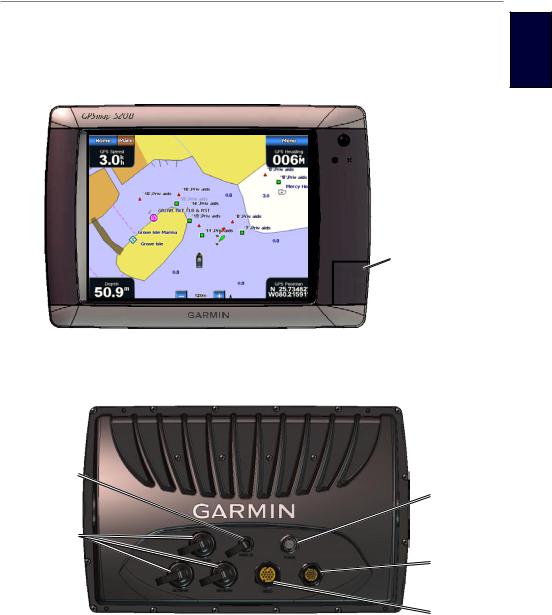
Front and Rear Panels
Getting Started
ettinG g tartedS
 Power key
 Automatic backlight sensor
SD card slot
GPSMAP 5208 - Front
NMEA 2000®
Power
Network
NMEA 0183
Video
GPSMAP 5212 - Back
GPSMAP 5000 Series Owner’s Manual |
|
Getting Started
Getting Started
Turning the Chartplotter On
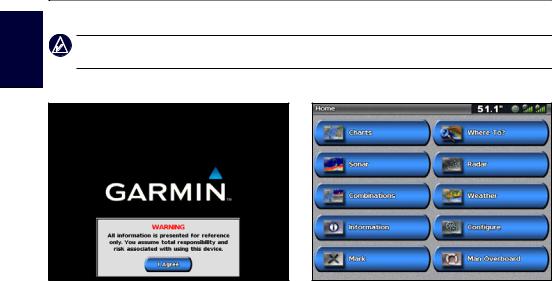
Note: The first time you power on your chartplotter, you must go through a setup sequence. See
“Initializing Chartplotter Settings”.
1. Press and release the Power key. After a few moments, the Warning screen appears.
Warning Screen |
Home Screen |
2. Touch I Agree to open the Home screen.
Turning the Chartplotter Off
To turn the chartplotter off, press and hold the Power key.
Initializing Chartplotter Settings
The first time you turn your chartplotter on, you must configure a series of initial settings.These settings must also be configured when restoring factory settings (page 4). All of these settings can be configured later from the Configure screen (page 36).
The initial settings are as follows:
•Language—touch the language that you want shown on your screen.
•Welcome—touch OK.
•Position Format—specify the coordinate system to use for location readings.
•Time Format—select 12-hour, 24-hour, or UTC (Universal Time Code) to specify the format in which time is displayed.
•Time Zone—select your time zone.
•Units—select Statute, Metric, or Nautical to specify units for on-screen measurements.
•Minimum Safe Depth—specify the minimum safe depth for your boat. Refer to your boat specifications for more information.
•Minimum Overhead Clearance—specify the minimum overhead clearance for your boat. Refer to your boat specifications for more information.
GPSMAP 5000 Series Owner’s Manual
Getting Started
Acquiring GPS Satellite Signals
When you turn the chartplotter on, the GPS receiver must collect satellite data and establish its current location.When the chartplotter acquires satellite signals, the signal strength bars at the top of the Home screen are green . When the chartplotter loses satellite signals, the green bars disappear
 and a flashing question mark appears on the boat icon on the chart screen.
For more information about GPS, visit the Garmin Web site at www.garmin.com/aboutGPS.
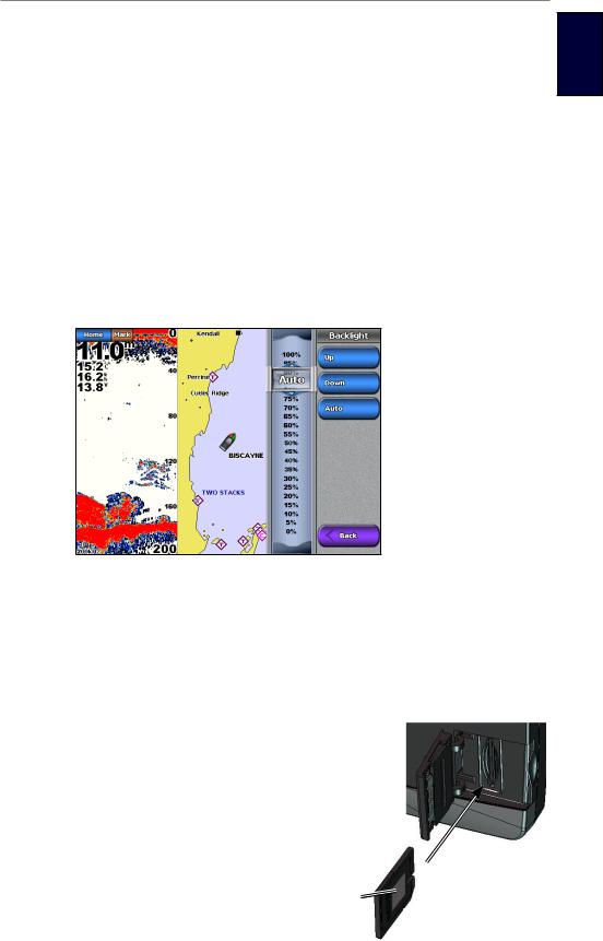
Adjusting the Backlight
1. While the chartplotter is on, press and quickly release the Power key.
2.Touch Backlight.
3.Select an option to adjust the backlight:
•To allow the chartplotter to automatically adjust the backlight based on ambient light, touch
Auto.
•To manually adjust the backlight, either touch and hold Up or Down, or touch and drag the brightness bar.
ettinG g tartedS
 Brightness bar
Adjusting the Color Mode
1.Press and quickly release the Power key.
2.Touch Color Mode.
3.Touch Day Colors, Night Colors, or Auto.
Inserting and Removing SD Cards
Your chartplotter supports SD (Secure Digital) cards. Insert optional BlueChart® g2 Vision® SD cards to view high-resolution satellite imagery and
aerial reference photos of ports, harbors, marinas, and other points of interest. Insert blank SD cards to transfer data such as waypoints, routes, and tracks to another compatible Garmin chartplotter or a computer (page 32). The SD card slot is located on the lowerright corner of the chartplotter.
• To insert the SD card, open the access door and
press the SD card until it clicks. |
Card label |
|
•To eject the SD card, press the card in again and release it.
GPSMAP 5000 Series Owner’s Manual |
3 |

Getting Started
Getting Started
Restoring the Original Factory Settings
 Caution: This procedure deletes any information you have entered.
1.From the Home screen, touch Configure > System > System Information > Factory Settings
> Reset.
2.Select an option:
• Touch Yes to restore all factory settings.
• Touch No to exit without restoring factory settings.
Viewing System Information
You can view the software version, basemap version, unit ID number, and your XM WX Weather® radio ID (if available). You may need this information to update the system software or purchase additional map data information.
From the Home screen, touch Configure > System > System Information.
Using the Simulator Mode
Simulator mode turns the GPS receiver off for use indoors or for practice. The chartplotter does not track satellites in simulator mode.
Caution: Do not try to navigate using simulator mode because the GPS receiver is turned off. Any satellite signal strength bars shown are only simulations and do not represent the strength of actual satellite signals.
1.From the Home screen, touch Configure > System > Simulator > On.
2.Touch Setup to set speed, track control (simulated heading), position, simulator time, and simulator date.
|
GPSMAP 5000 Series Owner’s Manual |
Getting Started
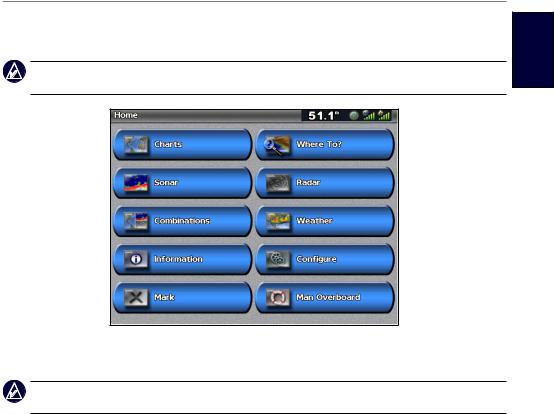
Understanding the Home Screen
Use the Home screen to access all other screens.
Note: Options on this screen vary based on the chartplotter type and optional connected network devices.
•Charts—selects Navigation Chart, Perspective 3D, Mariner’s Eye 3D, Fish Eye 3D, Fishing Chart, and Radar Overlay (page 6).
Note: Mariner’s Eye 3D, Fish Eye 3D, and Fishing Charts are available only if you use a BlueChart g2 Vision SD card.
•Sonar—sets up and provides sonar information (only available if the chartplotter is connected to a Garmin sonar module) (page 51).
•Combinations—sets up the screen to view a chart, sonar, radar, and video in a 2, 3, or 4-field split screen (page 21).
•Information—shows information including tides, currents, celestial data, user data, information about other boats, gauges, and video (page 30).
•Mark—marks, edits, or deletes your current location as a waypoint or Man Overboard (page 25).
•Where To?—provides navigation features (page 23).
•Radar—sets up and displays radar (only available if the chartplotter is connected to a radar module) (page 45).
•Weather—sets up and displays various weather parameters, including precipitation, forecast, fishing, sea conditions, and visibility (only available if the chartplotter is connected to a weather module and you have an XM® subscription) (page 59).
•Configure—allows you to view and edit your chartplotter and system settings (page 36).
•Man Overboard—marks your current location as a waypoint, and sets a course back to the marked location. (page 25).
ettinG g tartedS
GPSMAP 5000 Series Owner’s Manual |
5 |
Using Charts
Using Charts
Using Charts
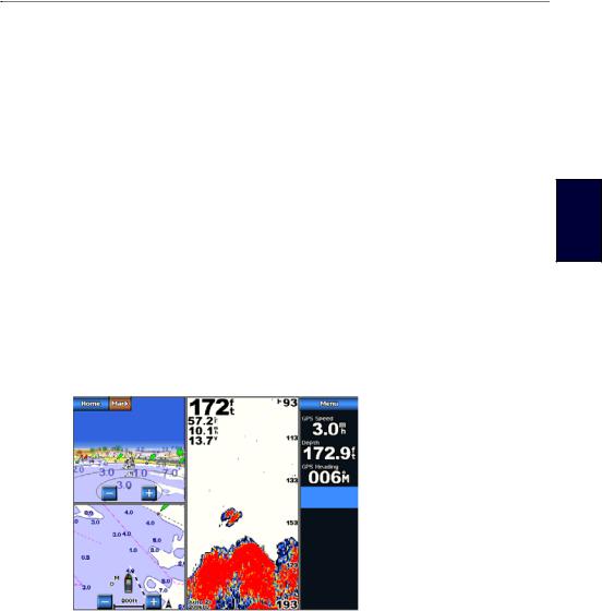
The GPSMAP 5000 series chartplotters have a basic worldwide imagery map and built-in detailed BlueChart g2 offshore cartography for US waters. The following options are available when you touch Charts on the Home screen:
•Navigation Chart—displays navigation data available on your preloaded maps, including buoys, lights, cables, depth soundings, marinas, and tide stations in an overhead view.
•Perspective 3D—displays a view from above and behind your boat for a visual navigation aid.
Note: Mariner’s Eye 3D, Fishing Charts and Fish Eye 3D views are available when using optional Blue Chart g2 Vision preprogrammed SD cards. See page 16.
•Mariner’s Eye 3D—displays a detailed, three dimensional view from above and behind the boat for a visual navigation aid.
•Fishing Chart—removes navigational data from the chart and enhances bottom contours for depth recognition.
•Fish Eye 3D—provides an underwater view that visually represents the sea floor according to the chart’s information.
The chartplotter selectively displays navigation data after you select the type of navigation you want.
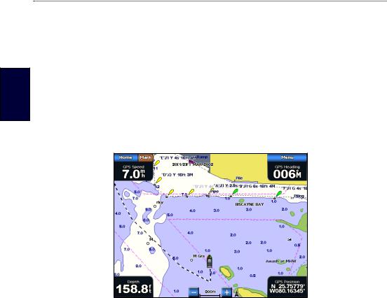
Using the Navigation Chart
Use the Navigation chart to plan your course, to view map information, and as a navigational aid.
From the Home screen, touch Charts > Navigation Chart.
Light |
|
|
Buoy |
|
|
|
Marine |
|
Your boat |
services |
|
Zoom scale |
||
|
Navigation Chart on a GPSMAP 5208
Zooming In and Out on the Map
The  and
and  keys control the zoom level, indicated by the scale at the bottom of the Navigation chart (
 ). The bar under the number represents that distance on the map.
Navigation Chart Settings
To access additional settings or options for the Navigation chart, touch Menu.
Waypoints & Tracks—view and add waypoints and tracks, and configure how they are displayed.
Other Vessels—view information about other vessels if your chartplotter is connected to an external
Automatic Identification System (AIS) or Digital Selective Calling (DSC) device.
|
GPSMAP 5000 Series Owner’s Manual |
Using Charts
Stop Navigation—stop navigating to your destination (only available while navigating). Chart Setup—customize the Navigation chart settings (page 11).
Data Bars—show or hide cruising, navigation, fishing, fuel, or sailing data.
sinUg hartC s
Data bars
•Cruising—turn the GPS Speed, GPS Heading, Depth, and GPS Position data bar on or off. Touch Data Bar Setup to configure the position of the data on the screen.
•Navigation—turn the Distance to Destination, Arrival, Off Course, and Bearing data bar on or off. If you touch Auto, the chartplotter turns the Navigation data bar on whenever you are navigating to a destination. Touch Data Bar Setup to configure the Route Leg, NextTurn, and
Destination options.
•Fishing—turn the Depth, Water Temperature, and Water Speed data bar on or off.
•Fuel—turn the Fuel Rate, Remaining Fuel, Range, and Fuel Economy data bar on or off.
•Sailing—turn the Water Speed, Wind Speed, Wind Angle, and Wind Velocity Made Good (VMG) data bar on or off. Select Wind to toggle between True and Apparent wind speed and wind angle.
Understanding How Wind VMG and Waypoint VMG Are Displayed in the Data Bars
The chartplotter automatically switches between displaying Wind Velocity Made Good (VMG) and Waypoint VMG in the data bars.
Waypoint VMG is displayed under the following conditions:
•The Route Leg data bar displays Waypoint VMG when you are navigating a route or an automatic guidance line.
•The Sailing data bar displays Waypoint VMG when you are navigating a route or an automatic guidance line, and you turn the Route Leg data bar off.
Wind VMG is displayed under the following conditions:
•The Sailing data bar displays Wind VMG when you are not navigating a route or an automatic guidance line.
•The Sailing data bar displays Wind VMG when the Route Leg data bar is on and you are navigating a route.
GPSMAP 5000 Series Owner’s Manual |
|
Using Charts
Understanding Chart Data
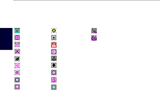
BlueChart g2 and BlueChart g2 Vision charts use graphic symbols to denote map features, which follow the standards for US and international charts. Some common symbols you might see include, but are not limited to, the following:*
Using
Charts |
|
|
Dangerous Rock |
|
Exposed Rock |
|
Beacon |
|
|
|
|
||||
|
|
Pilot Boarding Area |
|
Airport/Seaplane Base |
|
Buoy |
|
|
|
|
|
|
|
|
|
|
|
|
Anchorage Berth |
|
Precautionary Area |
|
|
|
|
|
|
|
|||
|
|
|
|
|
|||
|
|
|
Anchoring Prohibited |
|
Radio Report Point |
|
|
|
|
|
|
|
|||
|
|
|
Exposed Wreck |
|
Recommended Anchorage |
|
|
|
|
|
|
|
|||
|
|
|
|
|
|||
|
|
|
|
|
|||
|
|
|
Fishing Harbor |
|
Rescue Station |
|
|
|
|
|
|
|
|||
|
|
|
|
|
|||
|
|
|
Fishing Prohibited |
|
Tide Station |
|
|
|
|
|
|
|
|||
|
|
|
Information |
|
Yacht Harbor |
|
|
|
|
|
|
|
|||
|
|
|
Current Station |
|
Marine Services |
|
|
|
|
|
|
|
|||
|
|
|
|
|
|
|
|
*Some symbols might appear differently on your Garmin chartplotter.
Other features common to most charts include depth contour lines (with deep water represented in white), intertidal zones, spot soundings (as depicted on the original paper chart), navigational aids and symbols, and obstructions and cable areas.
Navigating to a Point on the Chart
1.From the Home screen, touch Charts.
2.Touch Navigation Chart, Fishing Chart, or Radar Overlay.
3.Touch the point on the chart where you want to go.
4.Touch Navigate To.
5.Select an option:
•Touch Go To.
•Touch Guide To when using a preprogrammed BlueChart g2 Vision card for Automatic Guidance (page 28).
6.Follow the colored line on the screen to the destination.
To create a route to a point on the chart, see page 27.
GPSMAP 5000 Series Owner’s Manual
Using Charts
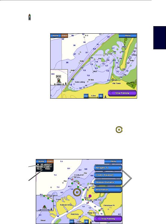
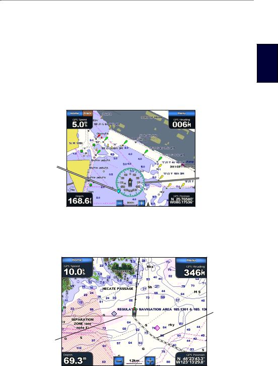
Panning the Navigation Chart
You can pan away from your current location and to scroll to other areas on the Navigation chart. The position icon ( ) stays at your present location. If the position icon leaves the map when you pan, a small window (inset map) appears on the left of the screen so you can keep track of your current position.
Inset map 
Panning on a Navigation Chart
1.Touch and drag the Navigation screen to pan the map.
2.Touch Stop Panning to stop panning and return the screen to your boat’s current location.
Interacting With Objects on the Navigation Chart
When you touch a point on the Navigation screen without dragging, a cursor |
appears at that |
spot, and a list of options appear along the right side. |
|
You can touch and drag the pointer to a new location. As you move the cursor, the coordinate location of the pointer is displayed in the upper-left corner of the map, along with the distance and bearing of the pointer from your current location.
sinUg hartC s
Pointer coordinates 
Pan Pointer distance options
and bearing from current location
Map cursor 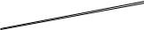
Inset  map
map
1.Touch a point on the Navigation chart.
2.Touch an option. The options that appear depend on the point you touched.
•Touch Review to view details of objects in vicinity of the cursor. (Review does not appear if the cursor is not near an object—if the cursor is near only one object, the name of the object appears.).
•Touch Navigate To to navigate to the selected location (page 8).
GPSMAP 5000 Series Owner’s Manual |
|
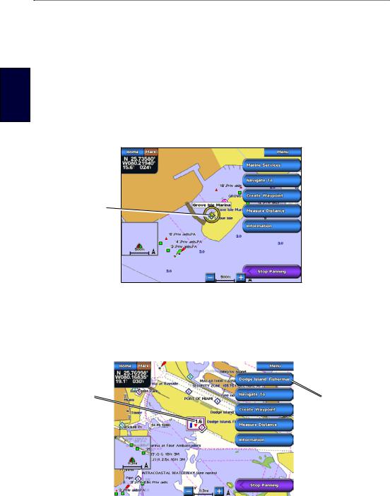
Using Charts
Using Charts
•Touch Create Waypoint to mark a waypoint at the cursor location (page 25).
•Touch Measure Distance to view the distance and bearing of the object from your current location. The information is displayed in the upper-left corner of the screen. Touch Set Reference to measure from a location other than your current location.
•Touch Information to view tide (page 30), current (page 30), celestial (page 31), or local services information near the cursor.
Accessing Additional Object Information
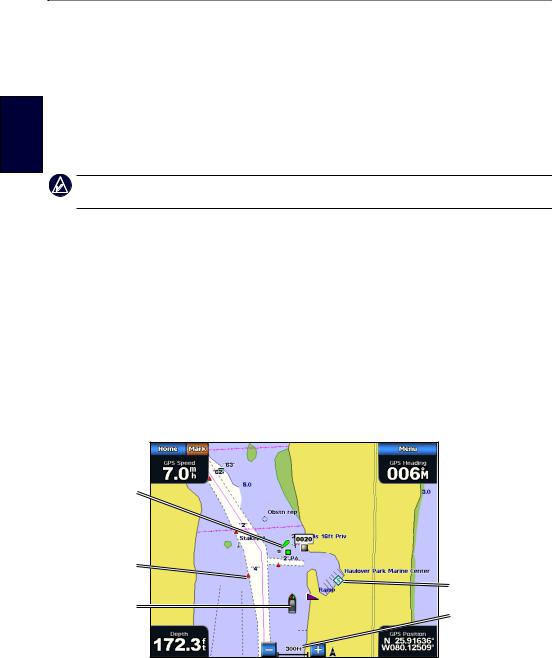
1.Touch an item on the screen to view information about on-screen map items, waypoints, and charts.
2.Touch the button with the name of the item to view the information.
 Additional
object Selected information
item 
Object Selected on a GPSMAP 5208
Viewing Tide-Station Information
Tide-station information appears on the chart with a detailed icon showing the relevant tide level. You can view a detailed graph for a tide station to help predict the tide level at different times or on different days. For more information about tides, see page 30.
Tide level |
|
Detailed |
|
tide station |
|
|
|
|
|
|
information |
|
|
|
Tide Station Selected on a GPSMAP 5208
1. Touch a tide station icon ( ).
).
2.To view a detailed tide graph:
•Touch the button with the station name.
•Touch Review if more than one item is in the vicinity, and then touch the button with the station name.
10 |
GPSMAP 5000 Series Owner’s Manual |
Using Charts
Changing the Navigation Chart Settings
From the Home screen, touch Charts > Navigation Chart > Menu > Chart Setup.
Photos—sets the high-resolution satellite images to Off, Land Only, or Photo Map. Highresolution satellite imagery is only available while using a BlueChart g2 Vision SD card (page 18).
Tides/Currents—turns the display of tides and currents on or off. Service Points—turns the display of marine service points on or off.
Roses—displays a compass rose around your boat, indicating compass direction. True wind direction or apparent wind direction can be displayed if the chartplotter is connected to a compatible marine wind sensor.
sinUg hartC s
Wind direction indicator
Compass rose
Wind Compass Rose
Changing the Chart Appearance
From the Home screen, touch Charts > Navigation Chart > Menu > Chart Setup > Chart Appearance.
Heading line 
Track
Chart border
Orientation—changes the perspective of the map display.
•North Up—sets the top of the map display to a north heading.
•Head Up—sets the map display to the current track heading.
•Course Up—sets the map so the direction of navigation is always up. The heading line appears vertically on the screen if shown.
Detail—adjusts the amount of detail shown on the map at different zoom levels.
GPSMAP 5000 Series Owner’s Manual |
|
Using Charts
Using Charts
Heading Line—draws an extension from the bow of the boat in the direction of travel.
•Off—turns the heading line off.
•Distance—sets the distance to the end of the heading line.
•Time—sets the amount of time until you reach the end of the heading line.
World Map—displays either a basic world map or displays satellite imagery (when Full World Map is selected).
Inset Map—turns the inset map on or off when panning away (page 9). Touch Auto to turn the inset map on only when the boat symbol is no longer visible.
Spot Depths—turns spot soundings on or off and sets a dangerous depth.
Safety Shading (with supported BlueChart g2 Vision cards)—Areas with depths shallower than the specified value are shaded in blue, while areas with depths greater than the specified value are shaded in white. The contour is always drawn at or deeper than the selected depth.
Symbols—changes symbol preferences.
•Navaid Size—adjusts the size of the navaid symbols shown on the map.
•Navaid Type—selects the navaid symbol set (NOAA or IALA).
•Land POIs—turns the display of land POIs (points of interest) on or off.
•Light Sectors—turns the sector in which a navigational light is visible on or off. Selecting On filters out light sectors depending on the zoom level.
•Chart Borders—turns chart borders on when using a BlueChart g2 Vision SD card and you want to see what area the maps cover.
Photo Points—turns camera icons on or off when using a BlueChart g2 Vision SD card.
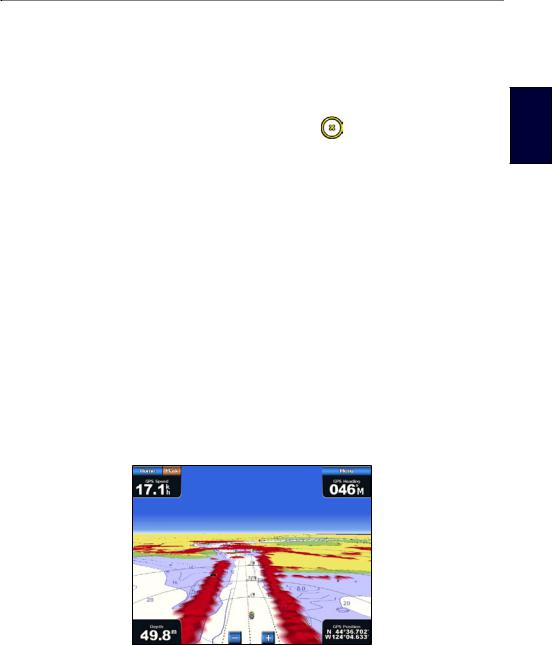
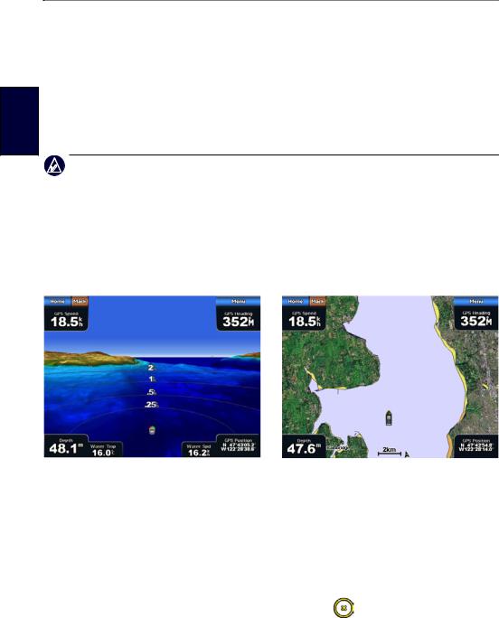
Using Perspective 3D
Perspective 3D provides a view from above and behind the boat (according to your course), and provides a visual navigation aid. This view is helpful when navigating tricky shoals, reefs, bridges, or channels, and is beneficial when trying to identify entry and exit routes in unfamiliar harbors or anchorages.
|
|
|
Perspective 3D |
Navigation Chart |
|
1. From the Home screen, touch Charts > Perspective 3D.
12 |
GPSMAP 5000 Series Owner’s Manual |
Using Charts
2.Use the  and
and  buttons to adjust the view:
•Touch the  button to move the view closer to your boat and lower to the water.
•Touch the  button to move the view away from the boat.
The view is momentarily indicated by the scale ( ) at the bottom of the screen.
To view details about navaids such as beacons, lights, and obstructions:
1. Use the touchscreen to point to the navaid. When the cursor |
is over the navaid, an option is |
displayed, such as Beacon or Light. |
|
2. Touch the option for the navaid to view details.
Perspective 3D Settings
To access additional settings or options from the Perspective 3D screen, touch Menu.
Waypoints & Tracks—view and add waypoints and tracks, and configure how they are displayed.
•Tracks—turn tracks on or off (page 14).
•Waypoints—view, sort, or filter existing waypoints, or create new ones (page 25).
•New Waypoint—edit, delete, or create a new waypoint (page 25).
•Active Tracks—manage tracks (page 14).
•Saved Tracks—view a list of tracks that have been saved.
Other Vessels—view information about other vessels. To view information about other vessels, your chartplotter must be connected to an externalAutomatic Identification System (AIS) or Digital
Selective Calling (DSC) device.
Surface Radar—display radar returns from the surface of the water when the chartplotter is connected to a marine radar (page 48).
sinUg hartC s
Perspective 3D With Surface Radar Information
Data Bars—show or hide cruising, navigation, fishing, fuel, or sailing numbers (page 7).
Chart Appearance—customize the Perspective 3D chart.
•Range Rings—toggles the range rings on or off. The range rings help you to visualize distances on the map.
•Safe Depth—adjusts the safe depth for your boat. If the chartplotter is connected to an optional sonar module and the shallow water alarm is activated (page 72), an alarm will sound when your boat enters water shallower than this setting.
•Lane Width—adjusts the width of the course line drawn when navigating. This setting also affects routes (Route To), but does not affect automatic guidance (Guide To).
GPSMAP 5000 Series Owner’s Manual |
3 |
Using Charts
Using Charts
Using Radar Overlay
When you connect your chartplotter to an optional Garmin marine radar, you can use Radar Overlay to overlay radar information on the Navigation chart (page 48).
Using Tracks
A track is a recording of your path. The track currently being recorded is the active track. An active track can be saved.
To turn the track log on:
From the Navigation or Perspective 3D chart, touch Menu > Waypoints & Tracks > Tracks > On. A trailing line on the chart indicates your track.
To save the active track:
1.From the Home screen, touch Information > User Data > Tracks > Save Active Track.
2.Select an option: the time the current track began or Midnight, if shown; or Entire Log.
3.Touch Edit Track to name the track, to change the color of the track, or to save it as a route.
To clear the active track:
From the Home screen, touch Information > User Data > Tracks > Clear Active Track. The track memory is cleared; the current track continues to be recorded.
To retrace the active track:
1.From the Home screen, touch Information > User Data > Tracks > Follow Active Track.
2.Select either the time the current track began or Entire Log.
3.Follow the colored line on the screen.
To edit or delete a saved track:
1.From the Home screen, touch Information > User Data > Tracks > Saved Tracks.
2.Select a track to edit or delete.
3.Select an option:
•Touch Edit Track to change the name or color of the track.
•Touch Delete to delete the track.
•Touch Next Page to view information about the track.
14 |
GPSMAP 5000 Series Owner’s Manual |

Using Charts
To set active Track Options:
From the Home screen, touch Information > User Data > Tracks > Active Track Options.
Record Mode—touch Off, Fill, or Wrap.
•Off—does not record a track log.
•Fill—records a track log until the track memory is full.
•Wrap—continuously records the track log, replacing the oldest track data with new data.
Interval—defines the frequency at which the track plot is recorded. Recording more-frequent plots is more accurate but fills the track log faster.
•Interval—sets whether the interval is determined by distance, time, or resolution. (Touch
Change to set the quantity.)
◦Distance—records the track based on a distance between points.
◦Time—records the track based on a time interval.
◦Resolution—records the track plot based on a variance from your course. This setting is recommended for the most-efficient use of memory.The distance value (Change) is the maximum error allowed from the true course before recording a track point.
•Change—sets the value of the interval.
Track Color—sets the color of the track plot.
Using BlueChart g2 Vision
Optional BlueChart g2 Vision preprogrammed SD cards allow you to get the most out of your chartplotter. In addition to detailed marine charting, BlueChart g2 Vision has the following features:
•Mariner’s Eye 3D—provides a view from above and behind the boat for a three dimensional navigation aid. The BlueChart g2 Vision Mariner’s Eye 3D is more detailed than the preloaded data.
•Fish Eye 3D—provides an underwater, three-dimensional view that visually represents the sea floor according to the information on the chart.
•Fishing Charts—displays the chart with enhanced bottom contours and without navigational data.This chart works well for offshore deep-sea fishing.
•High Resolution Satellite Imagery—provides high resolution satellite images for a realistic view of the land and water on the Navigation chart.
•Aerial Photos—displays marinas and other navigationally significant aerial photos to help you visualize your surroundings.
•Detailed Roads and POI data—displays roads, restaurants, and other points of interest (POIs) along the shore.
•Auto Guidance—uses specified boat safe depth and chart data to determine the best course to your destination.
sinUg hartC s
GPSMAP 5000 Series Owner’s Manual |
5 |
Using Charts
Using Charts
Using a BlueChart g2 Vision SD Card
You can insert or remove a BlueChart g2 Vision SD card while your chartplotter is on or off. See page 3 for insertion and removal instructions.
BlueChart g2 Vision SD cards are not waterproof. When you are not using the card, keep it in the original packaging for safekeeping and store it away from exposure to sun and rain.
BlueChart g2 Vision SD cards are susceptible to damage from static electricity. In low humidity environments, you should ground yourself on a large metal object before handling the card.
Note: You cannot transfer BlueChart g2 Vision data from the SD card to your computer for backup or viewing purposes. You can use the SD card only on BlueChart g2 Vision-compatible Garmin GPS units.
Using Mariner’s Eye 3D
A BlueChart g2 Vision SD card offers Mariner’s Eye 3D, which provides a detailed, three dimensional view from above and behind the boat (according to your course) and provides a visual navigation aid. This view is helpful when navigating tricky shoals, reefs, bridges, or channels, and when trying to identify entry and exit routes in unfamiliar harbors or anchorages.
|
|
|
Mariner’s Eye 3D |
Navigation Chart |
|
1.From the Home screen, touch Charts > Perspective 3D.
2.Use the  and
and  buttons to adjust the view:
•Touch the  button to move the view closer to your boat and lower to the water.
•Touch the  button to move the view away from the boat.
The view is momentarily indicated by the scale ( ) at the bottom of the screen.
To view details about navaids such as beacons, lights, and obstructions:
1. Use the touchscreen to point to the navaid. When the cursor |
is over the navaid, an option is |
displayed, such as as Beacon or Light. |
|
2. Touch the option for the navaid to view details.
Mariner’s Eye 3D Settings
To access additional settings or options from the Mariner’s Eye 3D screen, touch Menu.
For settings and options related to Waypoints & Tracks, Other Vessels, Surface Radar, and Data Bars, see “Perspective 3D Settings” on page 13.
To customize the appearance of the Mariner’s Eye 3D screen, touch Menu > Chart Appearance. Style—select how chart data is displayed over 3D terrain.
16 |
GPSMAP 5000 Series Owner’s Manual |
Using Charts
•Classic—use color schemes to indicate 3D terrain.
•Charts—provide chart information in a 3D view.
•Photos—provide satellite photo imagery in addition to chart information.
Hazard Colors—turns hazard colors on or off. The Off setting shows the land as seen from the water. The On setting indicates shallow water and land with a color scale. Blue indicates deep water, yellow is shallow water, and red is very shallow water.
sinUg hartC s
Mariner’s Eye 3D, Normal Colors |
Mariner’s Eye 3D, Hazard Colors |
For settings and options related to Range Rings, Safe Depth, and Lane Width, see page 11.
Using Fish Eye 3D
Using the depth contour lines of the BlueChart g2 Vision cartography, Fish Eye 3D provides an underwater view of the sea floor or lake bottom.The and buttons adjust the view in the same way as the Mariner’s Eye 3D.
Suspended targets (such as fish) are indicated by red, green, and yellow spheres. Red indicates the largest targets and green indicates the smallest.
Fish Eye 3D
Fish Eye 3D Settings
To access additional settings or options for the Fish Eye 3D screen, touch Menu. View—selects a fish-eye view of Fore,Aft, Port, or Starboard.
Sonar Cone—turns a cone on or off that shows the area covered by your transducer.
GPSMAP 5000 Series Owner’s Manual |
|
Using Charts
Using Charts
Sonar Data—visually shows the sonar readings received by your transducer for the best combination of sonar and mapping.
Tracks—turns the track log on or off.
Data Bars—shows or hides cruising, navigation, fishing, fuel, or sailing numbers (page 11).
Using Fishing Charts
Use the fishing chart for a detailed view of the bottom contours and depth soundings on the chart.
|
|
|
Fishing Chart |
Navigation Chart |
|
The fishing chart uses detailed bathymetric data on a preprogrammed BlueChart g2Vision SD card, and is best for offshore deep-sea fishing.
Enabling High Resolution Satellite Imagery
You can overlay high-resolution satellite images on the land, the sea, or both portions of the Navigation chart when using a preprogrammed BlueChart g2 Vision SD card.
NOTE: When enabled, the high resolution satellite images are only present at lower zoom levels. If you cannot see the high resolution images in your BlueChart g2 Vision region, either zoom in further by touching the and buttons, or set the detail level higher by touching Menu > Chart Setup >
Chart Appearance > Detail.
To enable satellite imagery:
1.While viewing the Navigation chart, touch Menu > Chart Setup > Appearance > Photos.
2.Select an option:
•Off—standard chart information is shown on the map.
•Land Only—standard chart information is shown on water with photos overlaying the land.
•Photo Map—photos overlay both the water and the land at a specified opacity. The higher you set the percentage, the more the satellite photos will cover both land and water.
18 |
GPSMAP 5000 Series Owner’s Manual |

Using Charts
sinUg hartC s
Photo Overlay Off |
|
Land Only Photo Overlay |
|
|
|
|
|
|
Photo Map at 50% |
Photo Map at 100% |
Viewing Aerial Photos
Preprogrammed BlueChart g2 Vision SD cards contain aerial photographs of many landmarks, marinas, and harbors. Use these photos to help orient yourself to your surroundings or to acquaint yourself with a marina or harbor prior to arrival.
1. On the Navigation chart, touch a camera icon.
• A standard camera icon ( ) indicates an overhead photo.
• A camera icon with a cone ( ) indicates a perspective photo. The photo was taken from the location of the camera, pointed in the direction of the cone.
2. Select Aerial Photo.
 Note: Touch
  and
and  to zoom in and out while viewing the aerial photo on the full screen.
Viewing Current Station Information
If current stations are available in your BlueChart g2 Vision region, they appear on the Navigation chart as a highlighted arrow. These detailed icons show the direction and speed of the current at a glance.
Touch Review or the name of the station to display a current graph. |
|
See page 30 for instructions on viewing current station information. |
Current Station icon |
|
Detailed Road and POI Data
BlueChart g2 Vision contains detailed road and POI data, which includes highly detailed coastal roads and points of interest (POIs) such as restaurants, lodging, local attractions, and more. For instructions on searching for and navigating to these POIs, see the “Where To?” section on page 23.
GPSMAP 5000 Series Owner’s Manual |
|

Using Charts
Using Automatic Guidance
Automatic Guidance automatically creates and suggests passage based on available BlueChart g2 Vision chart information. See page 40 for instructions on setting up Automatic Guidance for your boat. See page 28 to use Automatic Guidance.
Charts
Using
20 |
GPSMAP 5000 Series Owner’s Manual |
Using Combinations
Using Combinations
The Combinations screen displays a combination of different screens at the same time. The number of options available on the Combinations screen depends on the optional network devices you have connected to your GPSMAP 5000 series chartplotter and whether you are using an optional BlueChart g2 Vision SD card. You can combine two, three, or four screens. After you select a combination, you can customize it.
s
Selecting a Combination
1.From the Home screen, touch Combinations. A list of possible screen combinations is displayed.
2.Touch a combination.
Interacting with the Combinations Screen
You can view a combination screen at full screen and change the data field pane on the right side of the screen.
To add additional data fields:
1.From the Combinations screen, touch an unused data field. A list of digital items displayed.
2.Touch the digital item to be displayed on the Combinations screen. Available options vary, based on the chartplotter and network configuration.
sinUg ombinationC
 Unused data field
Adding a Data Field
To edit an existing data field:
1.While viewing the Combinations screen, touch a data field.
2.Touch the item to be displayed.
To change to full-screen view:
1.Touch a screen.
2.Select an option to return to the Combination screen:
•From the radar screen, touch Stop Pointing.
•From the chart screen, touch Stop Panning.
•From the sonar or video screen, touch Back.
GPSMAP 5000 Series Owner’s Manual |
21 |
Combinations
Using
Using Combinations
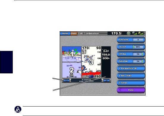
Editing the Combination Screen
1.Complete one of the following actions to access the Edit Combinations screen:
•While viewing a combinations screen, touch Menu > Change Combination.
•From the Home screen, touch Combinations > Unused Combo (if one is available).
Combination
screen 1 
Combination
screen 2 
XM bar
Data bar
2. Select an option to customize the Combinations screen:
Note: You can only choose from the options available to your chartplotter. To increase the number of screens available, use a BlueChart g2 Vision SD card or add network devices, such as sonar and radar.
•Touch Functions to select the number of combination screens.
•Touch Layout to change to vertical or horizontal layout.
•Touch XM Bar to toggle the XM bar on or off.
•Touch Data Bar to toggle the data bar on or off.
•Touch a numbered option, such as 1. Nav Chart or 2. Nav Chart in the example above, to select the combination screen to view.
To change the function of a screen:
1.Touch Menu > Change Combination. The charts are numbered, with a corresponding button on the right of the screen.
2.Touch the numbered button of the screen you want to change.
3.Touch the function that you want to appear in that screen.
22 |
GPSMAP 5000 Series Owner’s Manual |
Loading...