


 Loading...
GPS RECEIVER
GP-320B


 SAFETY INSTRUCTIONS
 CAUTION
Confirm that the power supply voltage is compatible with the voltage rating of the equipment.
Connection to the wrong power supply can cause fire or damage the equipment.
NOTICE
No one navigation device should ever be solely relied upon for the navigation of a vessel.
Always confirm position against all available aids to navigation, for safety of vessel and crew.
i

TABLE OF CONTENTS
SYSTEM OVERVIEW........................................................................................... |
iii |
EQUIPMENT LISTS .............................................................................................. |
v |
1. MOUNTING ....................................................................................................... |
1 |
2. WIRING ............................................................................................................. |
2 |
3. DEFAULT SETTINGS ....................................................................................... |
6 |
4. TROUBLESHOOTING, BATTERY ................................................................... |
7 |
SPECIFICATIONS........................................................................................... |
SP-1 |
PACKING LIST |
|
OUTLINE DRAWING |
|
Declaration of Conformity |
|
ii

SYSTEM OVERVIEW
The GP-320B is a GPS receiver with WAAS (Wide Area Augmentation System) capability. WAAS, available in North America, is a provider in the worldwide SBAS (Satellite Based Augmentation System) navigation system. An SBAS provider furnishes GPS signal corrections to SBAS users, for even better position accuracy, typically better than three meters. Two more SBAS providers are also currently under development, MSAS (Multi-Functional Satellite Augmentation System) for Japan and EGNOS (Euro Geostationary Navigation Overlay Service) for Europe. All providers will be compatible with one another, thus providing “seamless” position fixes to SBAS users.
SBAS is currently in the developmental phase and SBAS providers are expected to have initial operations capability from the times shown below. During the developmental phase the reliability and availability of the SBAS signal cannot be guaranteed.
150°W |
120°W |
90°W |
60°W |
30°W |
0 |
30°E |
60°E |
90°E |
120°E |
150°E |
|
60°N |
|
|
|
|
|
|
|
|
|
|
60°N |
40°N |
|
|
|
|
|
|
EGNOS |
|
MSAS |
40°N |
|
|
|
|
|
|
|
|
|
|
|
|
|
20°N |
|
|
|
|
|
|
|
|
|
|
20°N |
0 |
|
|
|
122 |
120 |
|
131 |
|
|
134 |
0 |
|
WAAS |
|
|
|
|
|
|
|
|
|
|
20°S |
|
|
|
|
|
|
|
|
|
|
20°S |
40°S |
|
|
|
|
|
|
|
|
|
|
40°S |
60°S |
|
|
|
|
|
|
|
|
|
|
60°S |
150°W |
120°W |
90°W |
60°W |
30°W |
0 |
30°E |
60°E |
90°E |
120°E |
150°E |
|
Satellite, Region |
Position |
120, AOR-E |
15.5°W |
122, AOR-W |
54°W |
131, IOR |
64.5°E |
134, POR |
178°E |
Expected operations capability WAAS: 2003
EGNOS: 2004
MSAS: 2005
Note: Unless otherwise noted, this manual uses “WAAS” when referring to any SBAS provider.
iii
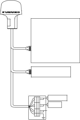
NavNet Series
Model 1722C |
Model 1833C |
Model 1722 |
Model 1933C |
Model 1732C |
Model 1943C |
Model 1732 |
Model 1833 |
Model 1742C |
Model 1933 |
Model 1742 |
Model 1943 |
Model 1752C |
Model 1953C |
Model 1752 |
GD-1900C |
Model 1762C |
GD-1700C |
Model 1762 |
GD-1700 |
Multi Display RD-30*
Echo Sounder LS-6100
* = WAAS is inoperative.
Other Equipment*
GD-XXXX
GR-80
Ship's Mains (12-24 VDC)
JUNCTION BOX
iv
Loading...